vi. consent items
TRANSCRIPT
Charles C. Morris
Chair Town of Linden
Donovan McLaurin Vice-Chair
Wade, Falcon & Godwin
Garland C. Hostetter, Town of Spring Lake
Harvey Cain, Jr., Town of Stedman
COUNTY of CUMBERLAND
Planning and Inspections Department
Thomas J. Lloyd, Director
Clifton McNeill, Jr., Roy Turner, Lori Epler,
Sara E. Piland, Cumberland County
TENTATIVE AGENDA JUNE 20, 2006
7:00 P.M.
I. INVOCATION AND PLEDGE OF ALLEGIANCE
II. ADJUSTMENTS TO AGENDA
III. PUBLIC HEARING DEFERRALS/WITHDRAWALS
A. P06-47: REZONING OF TWO PARCELS TOTALING 7.62+/- ACRES FROM A1 TO A1A, AT 3745 AND 3837 FINAL APPROACH DRIVE, SUBMITTED BY JONATHAN KEITH, OWNED BY O BREYTON KNOWLES HEIRS.
IV. ABSTENTIONS BY BOARD MEMBERS
V. POLICY STATEMENT REGARDING PUBLIC HEARING TIME LIMITS
VI. CONSENT ITEMS
A. APPROVAL OF THE MINUTES OF JUNE 6, 2006
REZONING/INITIAL ZONING CASES
B. P06-34: INITIAL ZONING AND REZONING OF 13.46 +/- ACRES FROM R6A TO R15 OR TO A MORE RESTRICTIVE ZONING DISTRICT, LOCATED
NORTH OF WADE-STEDMAN ROAD, WEST OF I-95, SUBMITTED BY THE TOWN OF WADE, OWNED BY MERRILL MCLAURIN. (WADE)
C. P06-39: REZONING OF FOUR PARCELS TOTALING 28.46 ACRES FROM A1 TO R40 OR TO A MORE RESTRICTIVE ZONING DISTRICT, AT 1750 WADE-STEDMAN ROAD, SUBMITTED BY HERMAN LOCKAMY, OWNED BY AUDREY FAULKNER.
D. P06-41: INITIAL ZONING OF 79.77 ACRES TO R5A AND C3 OR TO A MORE RESTRICTIVE ZONING DISTRICT, WEST OF LILLINGTON
HIGHWAY, SOUTH OF PINE KNOLL DRIVE, SUBMITTED BY THE TOWN OF SPRING LAKE, OWNED BY HUFF-CAVINESS LLC. (SPRING LAKE)
E. P06-42: REZONING OF 2.0 ACRES FROM R10 TO C(P) OR TO A MORE RESTRICTIVE ZONING DISTRICT, AT 2420 AND 2434 GEORGE OWEN ROAD, SUBMITTED BY TIM EVANS, OWNED BY WILLIAM C. AND VIDA L. LONG.
F. P06-43: REZONING OF 2.0 ACRES FROM A1 TO R40A OR TO A MORE
RESTRICTIVE ZONING DISTRICT, AT 7461 AND 7473 RUFUS JOHNSON ROAD, SUBMITTED BY TOMMY SMITH, OWNED BY CARRIAGE CROSSING, INC.
G. P06-46: REZONING OF THREE PARCELS TOTALING 3.64 ACRES FROM R6A AND C3 TO C(P) OR TO A MORE RESTRICTIVE ZONING DISTRICT, LOCATED ON THE WEST SIDE OF MURCHISON ROAD, AND ON THE NORTH AND SOUTH SIDES OF BERNADINE STREET, SUBMITTED BY JIM MOHLER, OWNED BY 96 INVESTORS, INC.
H. P06-48: REZONING OF 1.87 ACRES FROM R6 TO C1 OR TO A MORE RESTRICTIVE ZONING DISTRICT, AT 230 CHAPEL HILL ROAD, SUBMITTED BY AMMIE M. JENKINS, OWNED BY SANDHILLS FAMILY HERITAGE ASSOCIATION. (SPRING LAKE)
VII. PUBLIC HEARING ITEMS
REVISION/AMENDMENT
A. P06-33: REVISION AND AMENDMENT TO THE CUMBERLAND COUNTY ZONING ORDINANCE, AMENDING ARTICLE IV. PERMITTED, CONDITIONAL, AND SPECIAL USES, SECTION 403 USE MATRIX, TO ALLOW SINGLE FAMILY DWELLING TO BE PERMITTED ON THE SECOND FLOOR AND ABOVE FOR COMMERCIAL, RETAIL & OFFICE SPACE IN THE C(P) DISTRICT, SUBMITTED BY BRADLEY W. YOUNG.
REZONING CASES
B. P06-37: REZONING OF THREE PARCELS TOTALING 45.61 ACRES FROM A1 TO R15 OR TO A MORE RESTRICTIVE ZONING DISTRICT, SOUTH OF SAND HILL ROAD, WEST OF TOWER ROAD, SUBMITTED BY CHRISTOPHER ROBERTS, OWNED BY JAMES BUXTON, ANNIE M. FREEMAN AND THELMA BATTLE.
C. P06-40: REZONING OF 13.19 ACRES FROM R10 TO C(P) OR TO A MORE RESTRICTIVE ZONING DISTRICT, AT 6521 RAMSEY STREET, OWNED BY JAMES H. AND EVA S. SINGLETARY.
D. P06-44: REZONING OF .78+/- ACRES FROM C1 TO C3 OR TO A MORE RESTRICTIVE ZONING DISTRICT, AT 6769 CLINTON ROAD, OWNED BY
HARRY T. PARKER. (STEDMAN)
E. P06-45: REZONING OF .26 ACRES FROM R10 TO M(P) OR TO A MORE RESTRICTIVE ZONING DISTRICT, AT 3034 LEGION ROAD, SUBMITTED BY JIM MOHLER, OWNED BY DOUGLAS L. NEW.
F. P06-49: REZONING OF TWO PARCELS TOTALING 33.71 ACRES FROM
A1 TO M(P) OR TO A MORE RESTRICTIVE ZONING DISTRICT, NORTH AND SOUTH OF WADE-STEDMAN ROAD, ON THE WEST SIDE OF I-95, SUBMITTED BY JAMES A. MCLEAN III, OWNED BY LUTHER C. AND LINDA S. BARNES JR.
VIII. DISCUSSION
IX. FOR YOUR INFORMATION
A. DIRECTOR S UPDATE
X. ADJOURNMENT
Charles C. Morris
Chair Town of Linden
Donovan McLaurin Vice-Chair
Wade, Falcon & Godwin
Garland C. Hostetter, Town of Spring Lake
Harvey Cain, Jr., Town of Stedman
COUNTY of CUMBERLAND
Planning and Inspections Department
Thomas J. Lloyd, Director
Clifton McNeill, Jr., Roy Turner, Lori Epler,
Sara E. Piland, Cumberland County
M I N U T E S June 06, 2006
Members Present
Others Present
Mr. Donovan McLaurin, Vice-Chair Mr. Tom Lloyd, Director Mrs. Sara Piland Mr. Grainger Barrett, Mr. Harvey Cain, Jr. County Attorney Mrs. Lori Epler Mr. Garland Hostetter Mr. Roy Turner Mr. Clifton McNeill, Jr. Commissioner Diane Wheatley
I. INVOCATION AND PLEDGE OF ALLEGIANCE Mr. Turner delivered the invocation and led those present in the Pledge of Allegiance.
II. ADJUSTMENTS TO AGENDA
A motion was made by Mrs. Piland, seconded by Mr. Turner, to accept the agenda. Unanimous.
III. ABSTENTIONS BY BOARD MEMBERS
There were no abstentions.
IV. CONSENT ITEMS
A. APPROVAL OF THE MINUTES OF MAY 16, 2006 - A motion was made by Mrs. Piland, seconded by Mr. Hostetter, to approve the minutes as written. Unanimous approval.
PLAT & PLAN
B. 06-096: CONSIDERATION OF TRINITY GARDENS, ZERO LOT LINE SUBDIVISION REVIEW, REQUEST FOR A WAIVER FROM SECTIONS 3.17.C STREET DESIGN , CUMBERLAND COUNTY SUBDIVISION ORDINANCE, LOCATED ON THE EAST SIDE OF SR 1609 (W. REEVES BRIDGE ROAD), WEST OF US HWY. 401 (RAMSEY STREET)
A motion was made by Mr. McNeill, seconded by Ms. Epler, to remove case 06-096 from Consent to Public Hearing. Unanimous approval.
Mr. Lloyd reviewed case information for plat case 06-096. He stated that the waiver was for the length of the cul-de-sac and that the staff recommends approval based on the following: 1. Because the size and shape of the subject property is long and narrow, and with the limitations in the Subdivision
Ordinance restricting connection to private streets, strict compliance with the provisions of the Ordinance would cause a special hardship to the property owner and be inequitable; 2. The public purposes of the Subdivision and Zoning Ordinances would be served to an equal or greater degree with all proposed lots being provided adequate road frontage; and 3. The property owner is not being afforded any special privileges denied to others since the preferred means of access is by right-of-way rather than flag strips which is the alternative commonly used for compliance of the frontage requirements in the Ordinances.
Mr. Lloyd stated that a Class B private street is required by the Ordinance with gravel or crusher run. He clarified that the only approval being granted through this case was the lot subdivision and the cul-de-sac length.
Discussion followed on private street standards, number of units allowed per street, flag lots, and fire hydrant placement.
Mr. Morris asked the petitioner, Ms. Bobbitt, if she understood that fire hydrant placement would be required. She stated that she would voluntarily agree to placement of a fire hydrant 500 feet from Ramsey Street.
Mr. Lloyd stated that the conditions could be amended to include requirement of fire hydrant placement. The Board agreed to add the condition. A motion was made by Mr. McNeill, seconded by Mr. McLaurin, to accept the staff recommendation and grant the waiver from section 3.17C with the added condition of requirement of a fire hydrant 500 feet from Ramsey St. Unanimous.
Mr. McLaurin stated his disagreement with the current ordinance requirements regarding number of lots and units allowed per street. Mr. Lloyd stated that this subject had previously been addressed and that any change would have to be done as a revision.
V. DISCUSSION
Mr. Lloyd presented information on the Sewer Extension Policy.
VI. FOR YOUR INFORMATION
A. DIRECTOR S UPDATE
Mr. Lloyd advised the Board that the Nominating Committee had met prior to this evening s meeting.
VII. ADJOURNMENT
Mr. McNeill made a motion, seconded by Mrs. Piland, to adjourn the meeting at 8:50 p.m.
Charles C. Morris
Chair Town of Linden
Donovan McLaurin Vice-Chair
Wade, Falcon & Godwin Garland C. Hostetter, Town of Spring Lake
Harvey Cain, Jr., Town of Stedman
COUNTY of CUMBERLAND
Planning and Inspections Department
Thomas J. Lloyd, Director
Clifton McNeill, Jr., Roy Turner, Lori Epler,
Sara E. Piland, Cumberland County
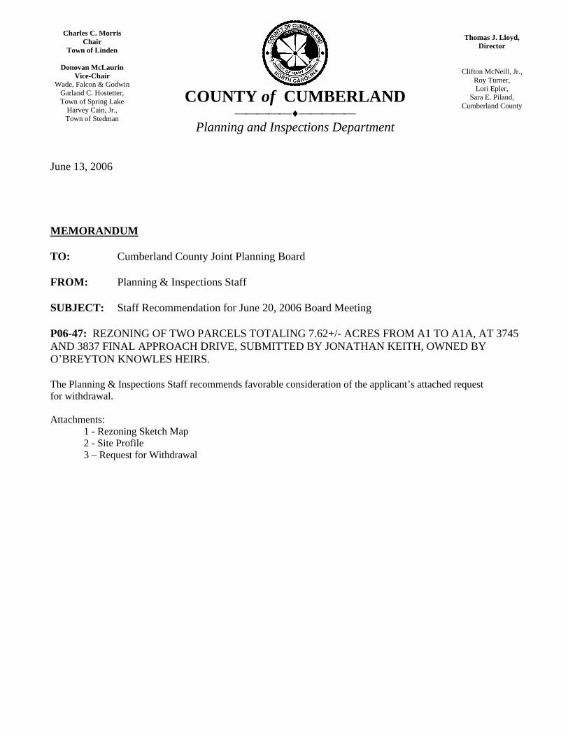
June 13, 2006
MEMORANDUM
TO: Cumberland County Joint Planning Board
FROM: Planning & Inspections Staff
SUBJECT: Staff Recommendation for June 20, 2006 Board Meeting
P06-47: REZONING OF TWO PARCELS TOTALING 7.62+/- ACRES FROM A1 TO A1A, AT 3745 AND 3837 FINAL APPROACH DRIVE, SUBMITTED BY JONATHAN KEITH, OWNED BY O BREYTON KNOWLES HEIRS.
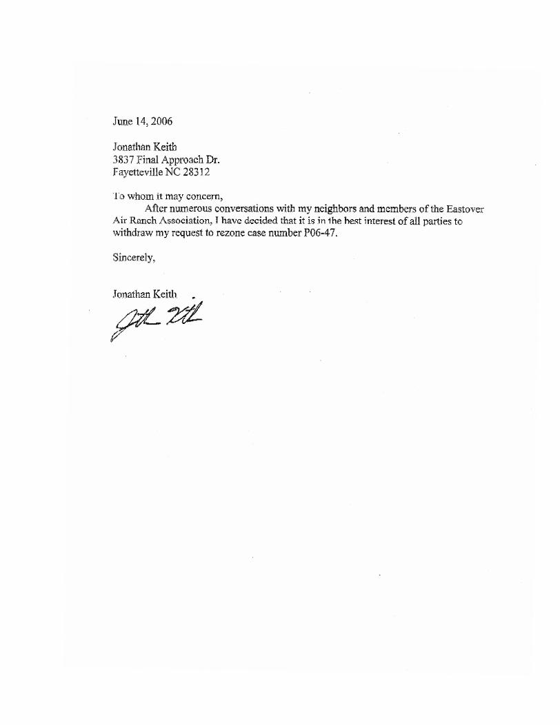
The Planning & Inspections Staff recommends favorable consideration of the applicant s attached request for withdrawal.
Attachments: 1 - Rezoning Sketch Map 2 - Site Profile 3 Request for Withdrawal
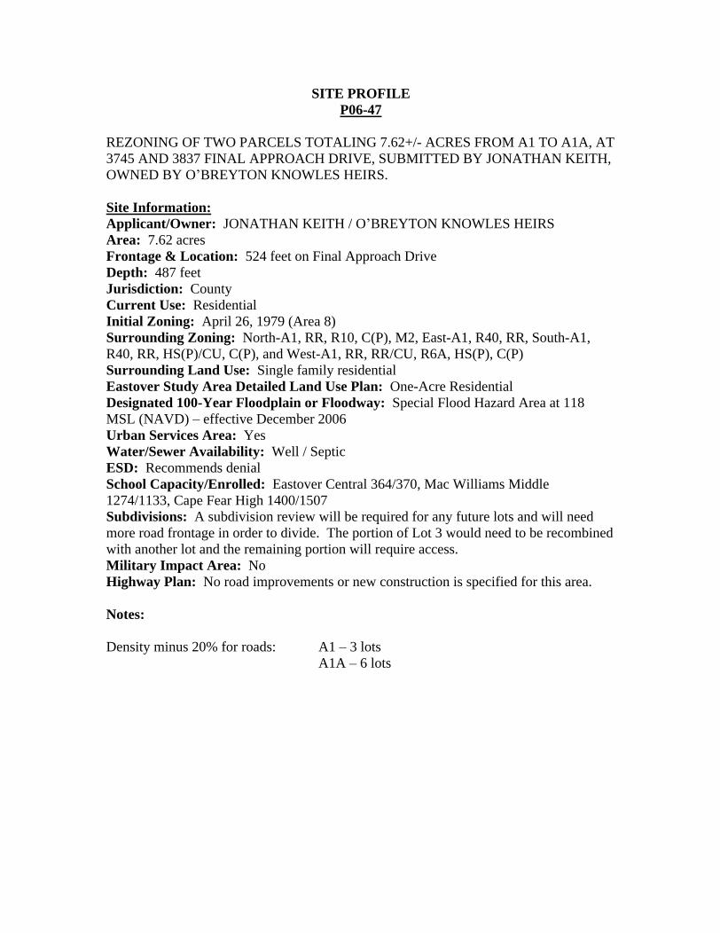
SITE PROFILE P06-47
REZONING OF TWO PARCELS TOTALING 7.62+/- ACRES FROM A1 TO A1A, AT 3745 AND 3837 FINAL APPROACH DRIVE, SUBMITTED BY JONATHAN KEITH, OWNED BY O BREYTON KNOWLES HEIRS.
Site Information:
Applicant/Owner: JONATHAN KEITH / O BREYTON KNOWLES HEIRS Area: 7.62 acres Frontage & Location: 524 feet on Final Approach Drive Depth: 487 feet Jurisdiction: County Current Use: Residential Initial Zoning: April 26, 1979 (Area 8) Surrounding Zoning: North-A1, RR, R10, C(P), M2, East-A1, R40, RR, South-A1, R40, RR, HS(P)/CU, C(P), and West-A1, RR, RR/CU, R6A, HS(P), C(P) Surrounding Land Use: Single family residential Eastover Study Area Detailed Land Use Plan: One-Acre Residential Designated 100-Year Floodplain or Floodway: Special Flood Hazard Area at 118 MSL (NAVD) effective December 2006 Urban Services Area: Yes Water/Sewer Availability: Well / Septic ESD: Recommends denial School Capacity/Enrolled: Eastover Central 364/370, Mac Williams Middle 1274/1133, Cape Fear High 1400/1507 Subdivisions: A subdivision review will be required for any future lots and will need more road frontage in order to divide. The portion of Lot 3 would need to be recombined with another lot and the remaining portion will require access. Military Impact Area: No Highway Plan: No road improvements or new construction is specified for this area.
Notes:
Density minus 20% for roads: A1 3 lots A1A 6 lots
Charles C. Morris
Chair Town of Linden
Donovan McLaurin Vice-Chair
Wade, Falcon & Godwin Garland C. Hostetter, Town of Spring Lake
Harvey Cain, Jr., Town of Stedman
COUNTY of CUMBERLAND
Planning and Inspections Department
Thomas J. Lloyd, Director
Clifton McNeill, Jr., Roy Turner, Lori Epler,
Sara E. Piland, Cumberland County
June 13, 2006
MEMORANDUM
TO: Cumberland County Joint Planning Board
FROM: Planning & Inspections Staff
SUBJECT: Staff Recommendation for June 20, 2006 Board Meeting
P06-34: INITIAL ZONING AND REZONING OF 13.46 +/- ACRES FROM R6A TO R15 OR TO A MORE RESTRICTIVE ZONING DISTRICT, LOCATED NORTH OF WADE-STEDMAN ROAD, WEST OF I-95, SUBMITTED BY THE TOWN OF WADE, OWNED BY MERRILL MCLAURIN. (WADE)
The Planning & Inspections Staff recommends approval of the R15 district based on the following:
1. The request is consistent with the Wade Study Area Detailed Land Use Plan; and
2. This request was initiated by the Town of Wade.
3. Town of Wade water and NORCRESS sewer are available to the site.
The R10 zoning district is the only other suitable district.
Attachments: 1 - Rezoning Sketch Map 2 - Site Profile
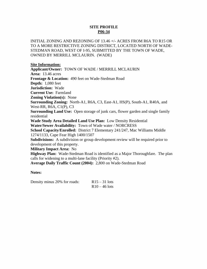
SITE PROFILE P06-34
INITIAL ZONING AND REZONING OF 13.46 +/- ACRES FROM R6A TO R15 OR TO A MORE RESTRICTIVE ZONING DISTRICT, LOCATED NORTH OF WADE-STEDMAN ROAD, WEST OF I-95, SUBMITTED BY THE TOWN OF WADE, OWNED BY MERRILL MCLAURIN. (WADE)
Site Information:
Applicant/Owner: TOWN OF WADE / MERRILL MCLAURIN Area: 13.46 acres Frontage & Location: 490 feet on Wade-Stedman Road Depth: 1,080 feet Jurisdiction: Wade Current Use: Farmland Zoning Violation(s): None Surrounding Zoning: North-A1, R6A, C3, East-A1, HS(P), South-A1, R40A, and West-RR, R6A, C1(P), C3 Surrounding Land Use: Open storage of junk cars, flower garden and single family residential Wade Study Area Detailed Land Use Plan: Low Density Residential Water/Sewer Availability: Town of Wade water / NORCRESS School Capacity/Enrolled: District 7 Elementary 241/247, Mac Williams Middle 1274/1133, Cape Fear High 1400/1507 Subdivisions: A subdivision or group development review will be required prior to development of this property. Military Impact Area: No Highway Plan: Wade-Stedman Road is identified as a Major Thoroughfare. The plan calls for widening to a multi-lane facility (Priority #2). Average Daily Traffic Count (2004): 2,800 on Wade-Stedman Road
Notes:
Density minus 20% for roads: R15 31 lots R10 46 lots
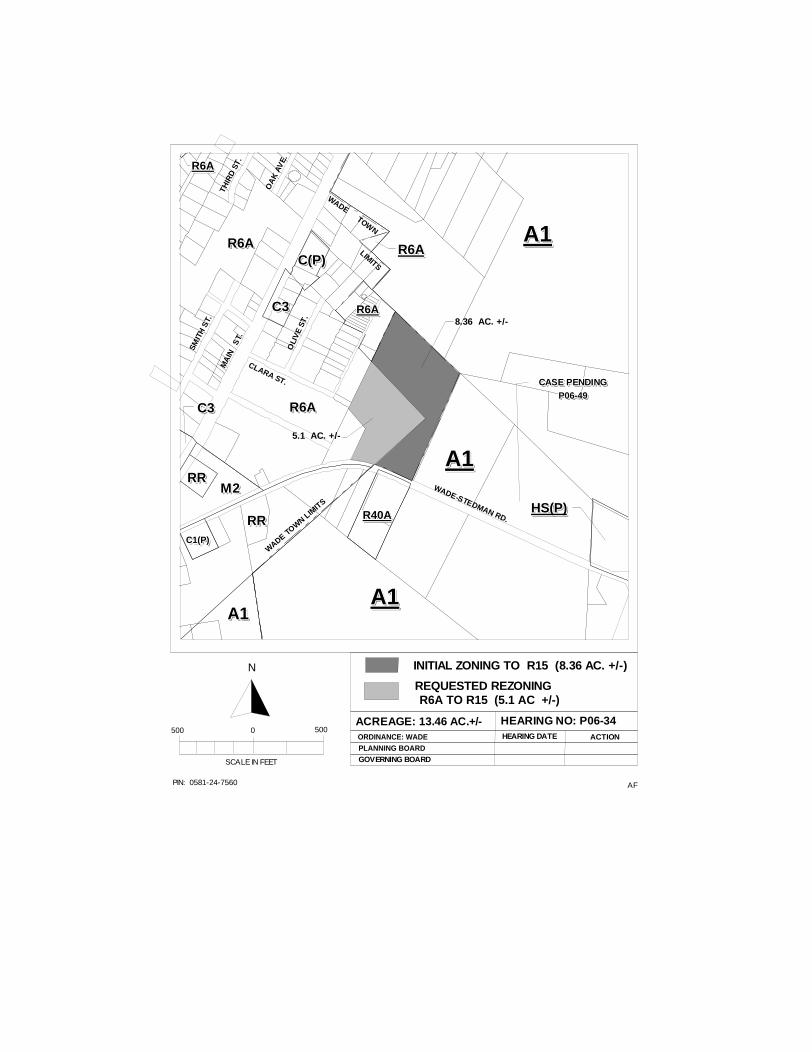
AFPIN: 0581-24-7560
INITIAL ZONING TO R15 (8.36 AC. +/-)
ACREAGE: 13.46 AC.+/- HEARING NO: P06-34ORDINANCE: WADEPLANNING BOARD
HEARING DATE ACTION
SCALE IN FEET
500 0 500
N
GOVERNING BOARD
C(P)C(P)C(P)C(P)C(P)C(P)C(P)C(P)C(P)C(P)
C3C3C3C3C3C3C3C3C3C3
RRRRRRRRRRRRRRRRRRRRM2M2M2M2M2M2M2M2M2M2
R6AR6AR6AR6AR6AR6AR6AR6AR6AR6A
RRRRRRRRRRRRRRRRRRRR
A1A1A1A1A1A1A1A1A1A1
R6AR6AR6AR6AR6AR6AR6AR6AR6AR6A
C1(P)C1(P)C1(P)C1(P)C1(P)C1(P)C1(P)C1(P)C1(P)C1(P)
A1A1A1A1A1A1A1A1A1A1
R40AR40AR40AR40AR40AR40AR40AR40AR40AR40A
A1A1A1A1A1A1A1A1A1A1
A1A1A1A1A1A1A1A1A1A1
R6AR6AR6AR6AR6AR6AR6AR6AR6AR6A
R6AR6AR6AR6AR6AR6AR6AR6AR6AR6A
HS(P)HS(P)HS(P)HS(P)HS(P)HS(P)HS(P)HS(P)HS(P)HS(P)
WADE TOW
N LIM
ITS
WADE-STEDMAN RD.
CLARA ST.
OLI
VE
ST.
SMIT
H S
T.
MA
IN
ST.
WADE TOW
N
LIMITSO
AK
AV
E.
THIR
D S
T.R6AR6AR6AR6AR6AR6AR6AR6AR6AR6A
REQUESTED REZONING R6A TO R15 (5.1 AC +/-)
C3C3C3C3C3C3C3C3C3C3
5.1 AC. +/-
8.36 AC. +/-
CASE PENDINGCASE PENDINGCASE PENDINGCASE PENDINGCASE PENDINGCASE PENDINGCASE PENDINGCASE PENDINGCASE PENDINGCASE PENDING
P06-49P06-49P06-49P06-49P06-49P06-49P06-49P06-49P06-49P06-49
Charles C. Morris
Chair Town of Linden
Donovan McLaurin Vice-Chair
Wade, Falcon & Godwin Garland C. Hostetter, Town of Spring Lake
Harvey Cain, Jr., Town of Stedman
COUNTY of CUMBERLAND
Planning and Inspections Department
Thomas J. Lloyd, Director
Clifton McNeill, Jr., Roy Turner, Lori Epler,
Sara E. Piland, Cumberland County
June 13, 2006
MEMORANDUM
TO: Cumberland County Joint Planning Board
FROM: Planning & Inspections Staff
SUBJECT: Staff Recommendation for June 20, 2006 Board Meeting
P06-39: REZONING OF FOUR PARCELS TOTALING 28.46 ACRES FROM A1 TO R40 OR TO A MORE RESTRICTIVE ZONING DISTRICT, AT 1750 WADE-STEDMAN ROAD, SUBMITTED BY HERMAN LOCKAMY, OWNED BY AUDREY FAULKNER.
The Planning & Inspections Staff recommends approval of the R40 district based on the following:
1. The request is consistent with the 2010 Land Use Plan; and
2. The request is consistent with the current zoning and lot sizes in the general area.
There are no other suitable districts.
Attachments: 1 - Rezoning Sketch Map 2 - Site Profile
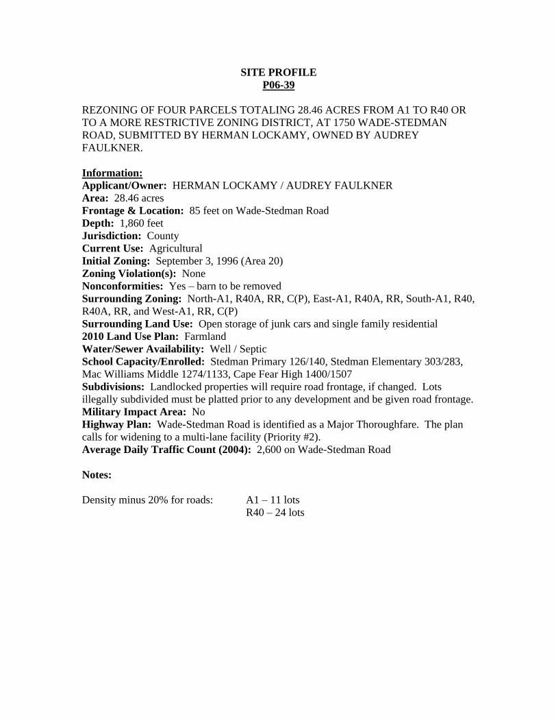
SITE PROFILE P06-39
REZONING OF FOUR PARCELS TOTALING 28.46 ACRES FROM A1 TO R40 OR TO A MORE RESTRICTIVE ZONING DISTRICT, AT 1750 WADE-STEDMAN ROAD, SUBMITTED BY HERMAN LOCKAMY, OWNED BY AUDREY FAULKNER.
Information:
Applicant/Owner: HERMAN LOCKAMY / AUDREY FAULKNER Area: 28.46 acres Frontage & Location: 85 feet on Wade-Stedman Road Depth: 1,860 feet Jurisdiction: County Current Use: Agricultural Initial Zoning: September 3, 1996 (Area 20) Zoning Violation(s): None Nonconformities: Yes barn to be removed Surrounding Zoning: North-A1, R40A, RR, C(P), East-A1, R40A, RR, South-A1, R40, R40A, RR, and West-A1, RR, C(P) Surrounding Land Use: Open storage of junk cars and single family residential 2010 Land Use Plan: Farmland Water/Sewer Availability: Well / Septic School Capacity/Enrolled: Stedman Primary 126/140, Stedman Elementary 303/283, Mac Williams Middle 1274/1133, Cape Fear High 1400/1507 Subdivisions: Landlocked properties will require road frontage, if changed. Lots illegally subdivided must be platted prior to any development and be given road frontage. Military Impact Area: No Highway Plan: Wade-Stedman Road is identified as a Major Thoroughfare. The plan calls for widening to a multi-lane facility (Priority #2). Average Daily Traffic Count (2004): 2,600 on Wade-Stedman Road
Notes:
Density minus 20% for roads: A1 11 lots R40 24 lots
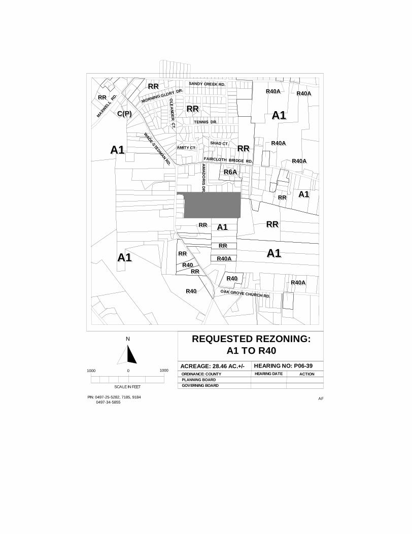
AFPIN: 0497-25-5282, 7185, 9184 0497-34-5855
REQUESTED REZONING:A1 TO R40
ACREAGE: 28.46 AC.+/- HEARING NO: P06-39ORDINANCE: COUNTYPLANNING BOARD
HEARING DATE ACTION
SCALE IN FEET
1000 0 1000
N
GOVERNING BOARD
A1A1A1A1A1A1A1A1A1A1 RRRRRRRRRRRRRRRRRRRR
A1A1A1A1A1A1A1A1A1A1
RRRRRRRRRRRRRRRRRRRR
R40R40R40R40R40R40R40R40R40R40
R40R40R40R40R40R40R40R40R40R40
RRRRRRRRRRRRRRRRRRRR
R6AR6AR6AR6AR6AR6AR6AR6AR6AR6A
RRRRRRRRRRRRRRRRRRRR
RRRRRRRRRRRRRRRRRRRR
R40AR40AR40AR40AR40AR40AR40AR40AR40AR40A
RRRRRRRRRRRRRRRRRRRR
A1A1A1A1A1A1A1A1A1A1
R40AR40AR40AR40AR40AR40AR40AR40AR40AR40A
RRRRRRRRRRRRRRRRRRRR
R40AR40AR40AR40AR40AR40AR40AR40AR40AR40A
R40AR40AR40AR40AR40AR40AR40AR40AR40AR40A
R40AR40AR40AR40AR40AR40AR40AR40AR40AR40A R40AR40AR40AR40AR40AR40AR40AR40AR40AR40A
C(P)C(P)C(P)C(P)C(P)C(P)C(P)C(P)C(P)C(P)
RRRRRRRRRRRRRRRRRRRR
A1A1A1A1A1A1A1A1A1A1
FAIRCLOTH BRIDGE RD.AM
AD
OR
IS D
R.
WADE-STEDM
AN RD.
OAK GROVE CHURCH RD.
TENNIS DR.
MORNING GLORY DR.
SANDY CREEK RD.
MAXW
ELL
RD.
OLE
AN
DE
R C
T.
SHAD CT.AMITY CT.
RRRRRRRRRRRRRRRRRRRR
RRRRRRRRRRRRRRRRRRRR
A1A1A1A1A1A1A1A1A1A1
A1A1A1A1A1A1A1A1A1A1
R40R40R40R40R40R40R40R40R40R40
Charles C. Morris
Chair Town of Linden
Donovan McLaurin Vice-Chair
Wade, Falcon & Godwin Garland C. Hostetter, Town of Spring Lake
Harvey Cain, Jr., Town of Stedman
COUNTY of CUMBERLAND
Planning and Inspections Department
Thomas J. Lloyd, Director
Clifton McNeill, Jr., Roy Turner, Lori Epler,
Sara E. Piland, Cumberland County
June 13, 2006
MEMORANDUM
TO: Cumberland County Joint Planning Board
FROM: Planning & Inspections Staff
SUBJECT: Staff Recommendation for June 20, 2006 Board Meeting
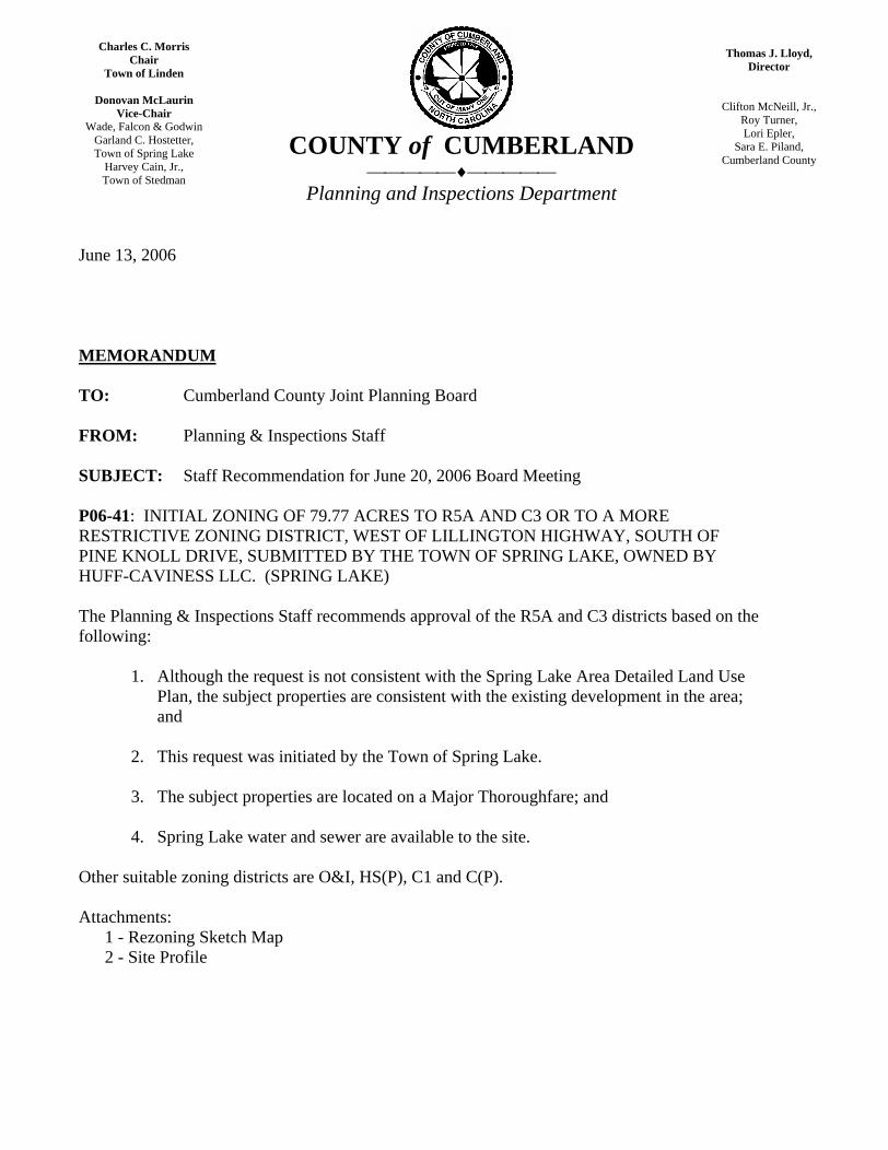
P06-41: INITIAL ZONING OF 79.77 ACRES TO R5A AND C3 OR TO A MORE RESTRICTIVE ZONING DISTRICT, WEST OF LILLINGTON HIGHWAY, SOUTH OF PINE KNOLL DRIVE, SUBMITTED BY THE TOWN OF SPRING LAKE, OWNED BY HUFF-CAVINESS LLC. (SPRING LAKE)
The Planning & Inspections Staff recommends approval of the R5A and C3 districts based on the following:
1. Although the request is not consistent with the Spring Lake Area Detailed Land Use Plan, the subject properties are consistent with the existing development in the area; and
2. This request was initiated by the Town of Spring Lake.
3. The subject properties are located on a Major Thoroughfare; and
4. Spring Lake water and sewer are available to the site.
Other suitable zoning districts are O&I, HS(P), C1 and C(P).
Attachments: 1 - Rezoning Sketch Map 2 - Site Profile
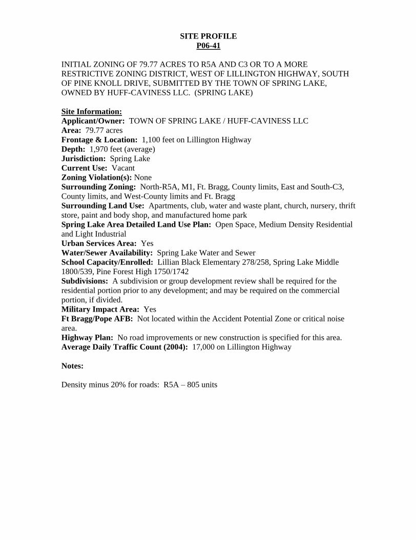
SITE PROFILE
P06-41
INITIAL ZONING OF 79.77 ACRES TO R5A AND C3 OR TO A MORE RESTRICTIVE ZONING DISTRICT, WEST OF LILLINGTON HIGHWAY, SOUTH OF PINE KNOLL DRIVE, SUBMITTED BY THE TOWN OF SPRING LAKE, OWNED BY HUFF-CAVINESS LLC. (SPRING LAKE)
Site Information:
Applicant/Owner: TOWN OF SPRING LAKE / HUFF-CAVINESS LLC Area: 79.77 acres Frontage & Location: 1,100 feet on Lillington Highway Depth: 1,970 feet (average) Jurisdiction: Spring Lake Current Use: Vacant Zoning Violation(s): None Surrounding Zoning: North-R5A, M1, Ft. Bragg, County limits, East and South-C3, County limits, and West-County limits and Ft. Bragg Surrounding Land Use: Apartments, club, water and waste plant, church, nursery, thrift store, paint and body shop, and manufactured home park Spring Lake Area Detailed Land Use Plan: Open Space, Medium Density Residential and Light Industrial Urban Services Area: Yes Water/Sewer Availability: Spring Lake Water and Sewer School Capacity/Enrolled: Lillian Black Elementary 278/258, Spring Lake Middle 1800/539, Pine Forest High 1750/1742 Subdivisions: A subdivision or group development review shall be required for the residential portion prior to any development; and may be required on the commercial portion, if divided. Military Impact Area: Yes Ft Bragg/Pope AFB: Not located within the Accident Potential Zone or critical noise area. Highway Plan: No road improvements or new construction is specified for this area. Average Daily Traffic Count (2004): 17,000 on Lillington Highway
Notes:
Density minus 20% for roads: R5A 805 units
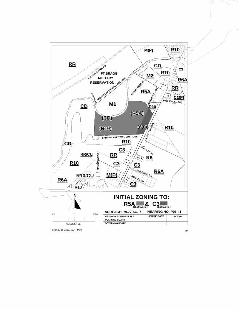
SPPIN: 0512-15-2510, 5904, 4400
INITIAL ZONING TO:R5A & C3
ACREAGE: 79.77 AC.+/- HEARING NO: P06-41ORDINANCE: SPRING LAKEPLANNING BOARD
GOVERNING BOARD
HEARING DATE ACTION
SCALE IN FEET
1000 0 1000
N
LILL
ING
TON
HW
Y
LILL
ING
TON
HW
Y
LILL
ING
TON
HW
Y
LILL
ING
TON
HW
Y
LILL
ING
TON
HW
Y
LILL
ING
TON
HW
Y
LILL
ING
TON
HW
Y
LILL
ING
TON
HW
Y
LILL
ING
TON
HW
Y
LANGLEY RD
LANGLEY RD
LANGLEY RD
LANGLEY RD
LANGLEY RD
LANGLEY RD
LANGLEY RD
LANGLEY RD
LANGLEY RD
WHEELESS RD
WHEELESS RD
WHEELESS RD
WHEELESS RD
WHEELESS RD
WHEELESS RD
WHEELESS RD
WHEELESS RD
WHEELESS RDROSSER RD
ROSSER RD
ROSSER RD
ROSSER RD
ROSSER RD
ROSSER RD
ROSSER RD
ROSSER RD
ROSSER RD
PINE KNOLL DRPINE KNOLL DRPINE KNOLL DRPINE KNOLL DRPINE KNOLL DRPINE KNOLL DRPINE KNOLL DRPINE KNOLL DRPINE KNOLL DR
WA
TER
FALL
WA
Y
WA
TER
FALL
WA
Y
WA
TER
FALL
WA
Y
WA
TER
FALL
WA
Y
WA
TER
FALL
WA
Y
WA
TER
FALL
WA
Y
WA
TER
FALL
WA
Y
WA
TER
FALL
WA
Y
WA
TER
FALL
WA
Y
RIVERS E
DGE R
D
RIVERS E
DGE R
D
RIVERS E
DGE R
D
RIVERS E
DGE R
D
RIVERS E
DGE R
D
RIVERS E
DGE R
D
RIVERS E
DGE R
D
RIVERS E
DGE R
D
RIVERS E
DGE R
D
HA
RP
S S
T
HA
RP
S S
T
HA
RP
S S
T
HA
RP
S S
T
HA
RP
S S
T
HA
RP
S S
T
HA
RP
S S
T
HA
RP
S S
T
HA
RP
S S
T
E MANCHESTER R
D
E MANCHESTER R
D
E MANCHESTER R
D
E MANCHESTER R
D
E MANCHESTER R
D
E MANCHESTER R
D
E MANCHESTER R
D
E MANCHESTER R
D
E MANCHESTER R
D
KIN
GS
TO
WN
CT
KIN
GS
TO
WN
CT
KIN
GS
TO
WN
CT
KIN
GS
TO
WN
CT
KIN
GS
TO
WN
CT
KIN
GS
TO
WN
CT
KIN
GS
TO
WN
CT
KIN
GS
TO
WN
CT
KIN
GS
TO
WN
CT
SPRING LAKE TOW
N LIMIT LIN
E
SPRING LAKE TOW
N LIMIT LIN
E
SPRING LAKE TOW
N LIMIT LIN
E
SPRING LAKE TOW
N LIMIT LIN
E
SPRING LAKE TOW
N LIMIT LIN
E
SPRING LAKE TOW
N LIMIT LIN
E
SPRING LAKE TOW
N LIMIT LIN
E
SPRING LAKE TOW
N LIMIT LIN
E
SPRING LAKE TOW
N LIMIT LIN
E
SPRING LAKE TOWN LIMIT LINESPRING LAKE TOWN LIMIT LINESPRING LAKE TOWN LIMIT LINESPRING LAKE TOWN LIMIT LINESPRING LAKE TOWN LIMIT LINESPRING LAKE TOWN LIMIT LINESPRING LAKE TOWN LIMIT LINESPRING LAKE TOWN LIMIT LINESPRING LAKE TOWN LIMIT LINE
CDCDCDCDCDCDCDCDCDCD
CDCDCDCDCDCDCDCDCDCD
R10R10R10R10R10R10R10R10R10R10
RRRRRRRRRRRRRRRRRRRR
M(P)M(P)M(P)M(P)M(P)M(P)M(P)M(P)M(P)M(P)
R10R10R10R10R10R10R10R10R10R10
R6AR6AR6AR6AR6AR6AR6AR6AR6AR6A
RRRRRRRRRRRRRRRRRRRR
R10R10R10R10R10R10R10R10R10R10M2M2M2M2M2M2M2M2M2M2
CDCDCDCDCDCDCDCDCDCDC3C3C3C3C3C3C3C3C3
R6AR6AR6AR6AR6AR6AR6AR6AR6AR6A
R6R6R6R6R6R6R6R6R6R6
C3C3C3C3C3C3C3C3C3C3
C3C3C3C3C3C3C3C3C3C3
RR/CURR/CURR/CURR/CURR/CURR/CURR/CURR/CURR/CURR/CU
R10/CUR10/CUR10/CUR10/CUR10/CUR10/CUR10/CUR10/CUR10/CUR10/CUR6AR6AR6AR6AR6AR6AR6AR6AR6AR6A
R10R10R10R10R10R10R10R10R10R10
C3C3C3C3C3C3C3C3C3C3
C3C3C3C3C3C3C3C3C3C3
M1M1M1M1M1M1M1M1M1M1
(R5A)(R5A)(R5A)(R5A)(R5A)(R5A)(R5A)(R5A)(R5A)(R5A)
(C(P))(C(P))(C(P))(C(P))(C(P))(C(P))(C(P))(C(P))(C(P))(C(P))
R10R10R10R10R10R10R10R10R10R10
(CD)(CD)(CD)(CD)(CD)(CD)(CD)(CD)(CD)(CD)
R5AR5AR5AR5AR5AR5AR5AR5AR5AR5AC1(P)C1(P)C1(P)C1(P)C1(P)C1(P)C1(P)C1(P)C1(P)C1(P)
M(P)M(P)M(P)M(P)M(P)M(P)M(P)M(P)M(P)M(P) R10R10R10R10R10R10R10R10R10R10
RRRRRRRRRRRRRRRRRRRR
R10R10R10R10R10R10R10R10R10R10
FT.BRAGG FT.BRAGG FT.BRAGG FT.BRAGG FT.BRAGG FT.BRAGG FT.BRAGG FT.BRAGG FT.BRAGG MILITARY MILITARY MILITARY MILITARY MILITARY MILITARY MILITARY MILITARY MILITARYRESERVATIONRESERVATIONRESERVATIONRESERVATIONRESERVATIONRESERVATIONRESERVATIONRESERVATIONRESERVATION
(69.79 AC.+/-) (9.98 AC.+/-)
(R10)(R10)(R10)(R10)(R10)(R10)(R10)(R10)(R10)(R10)
Charles C. Morris
Chair Town of Linden
Donovan McLaurin Vice-Chair
Wade, Falcon & Godwin Garland C. Hostetter, Town of Spring Lake
Harvey Cain, Jr., Town of Stedman
COUNTY of CUMBERLAND
Planning and Inspections Department
Thomas J. Lloyd, Director
Clifton McNeill, Jr., Roy Turner, Lori Epler,
Sara E. Piland, Cumberland County
June 13, 2006
MEMORANDUM
TO: Cumberland County Joint Planning Board
FROM: Planning & Inspections Staff
SUBJECT: Staff Recommendation for June 20, 2006 Board Meeting
P06-42: REZONING OF 2.0 ACRES FROM R10 TO C(P) OR TO A MORE RESTRICTIVE ZONING DISTRICT, AT 2420 AND 2434 GEORGE OWEN ROAD, SUBMITTED BY TIM EVANS, OWNED BY WILLIAM C. AND VIDA L. LONG.
The Planning & Inspections Staff recommends approval of the C(P) district based on the following:
1. Although the request is not consistent with the 2010 Land Use Plan, the subject properties are located on the Hope Mills Bypass near a major intersection; and
2. The request is consistent with the current zoning in the area; and
3. Public water and sewer are available to the site; and
4. John Brady Road is an appropriate stop point for the rezoning of properties in this area to commercial zoning.
Other suitable zoning districts are R6, R6A, R5, R5A, O&I(P) and C1(P).
Attachments: 1 - Rezoning Sketch Map 2 - Site Profile
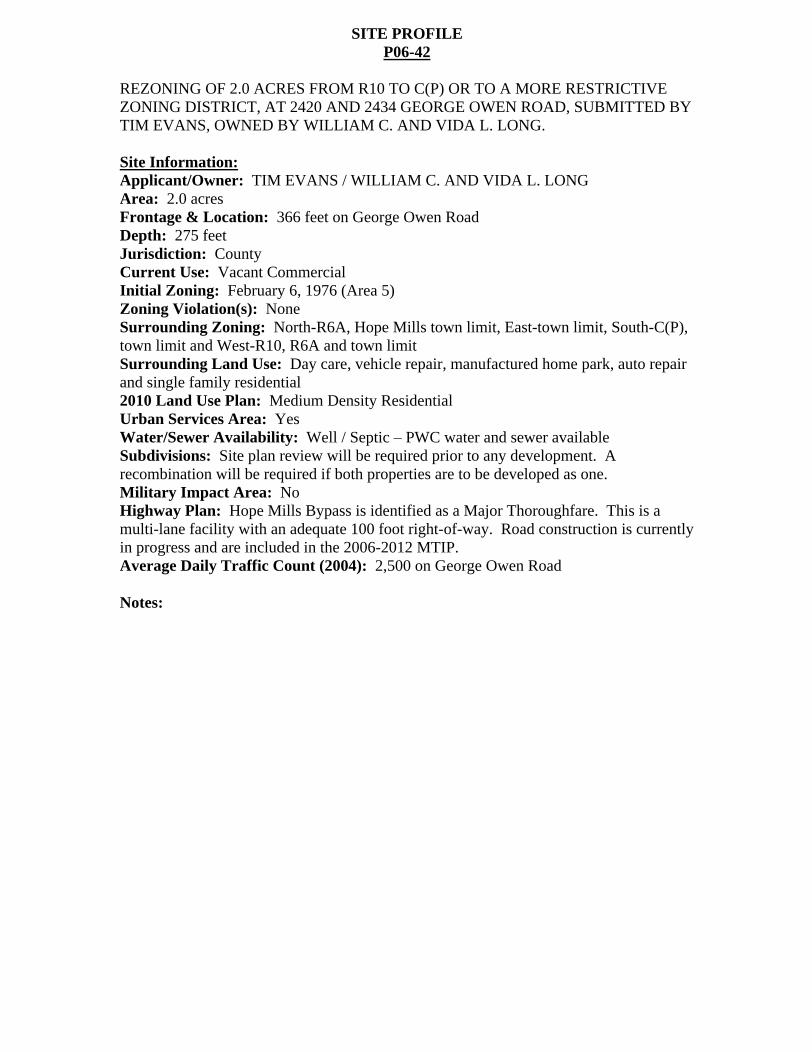
SITE PROFILE P06-42
REZONING OF 2.0 ACRES FROM R10 TO C(P) OR TO A MORE RESTRICTIVE ZONING DISTRICT, AT 2420 AND 2434 GEORGE OWEN ROAD, SUBMITTED BY TIM EVANS, OWNED BY WILLIAM C. AND VIDA L. LONG.
Site Information:
Applicant/Owner: TIM EVANS / WILLIAM C. AND VIDA L. LONG Area: 2.0 acres Frontage & Location: 366 feet on George Owen Road Depth: 275 feet Jurisdiction: County Current Use: Vacant Commercial Initial Zoning: February 6, 1976 (Area 5) Zoning Violation(s): None Surrounding Zoning: North-R6A, Hope Mills town limit, East-town limit, South-C(P), town limit and West-R10, R6A and town limit Surrounding Land Use: Day care, vehicle repair, manufactured home park, auto repair and single family residential 2010 Land Use Plan: Medium Density Residential Urban Services Area: Yes Water/Sewer Availability: Well / Septic PWC water and sewer available Subdivisions: Site plan review will be required prior to any development. A recombination will be required if both properties are to be developed as one. Military Impact Area: No Highway Plan: Hope Mills Bypass is identified as a Major Thoroughfare. This is a multi-lane facility with an adequate 100 foot right-of-way. Road construction is currently in progress and are included in the 2006-2012 MTIP. Average Daily Traffic Count (2004): 2,500 on George Owen Road
Notes:
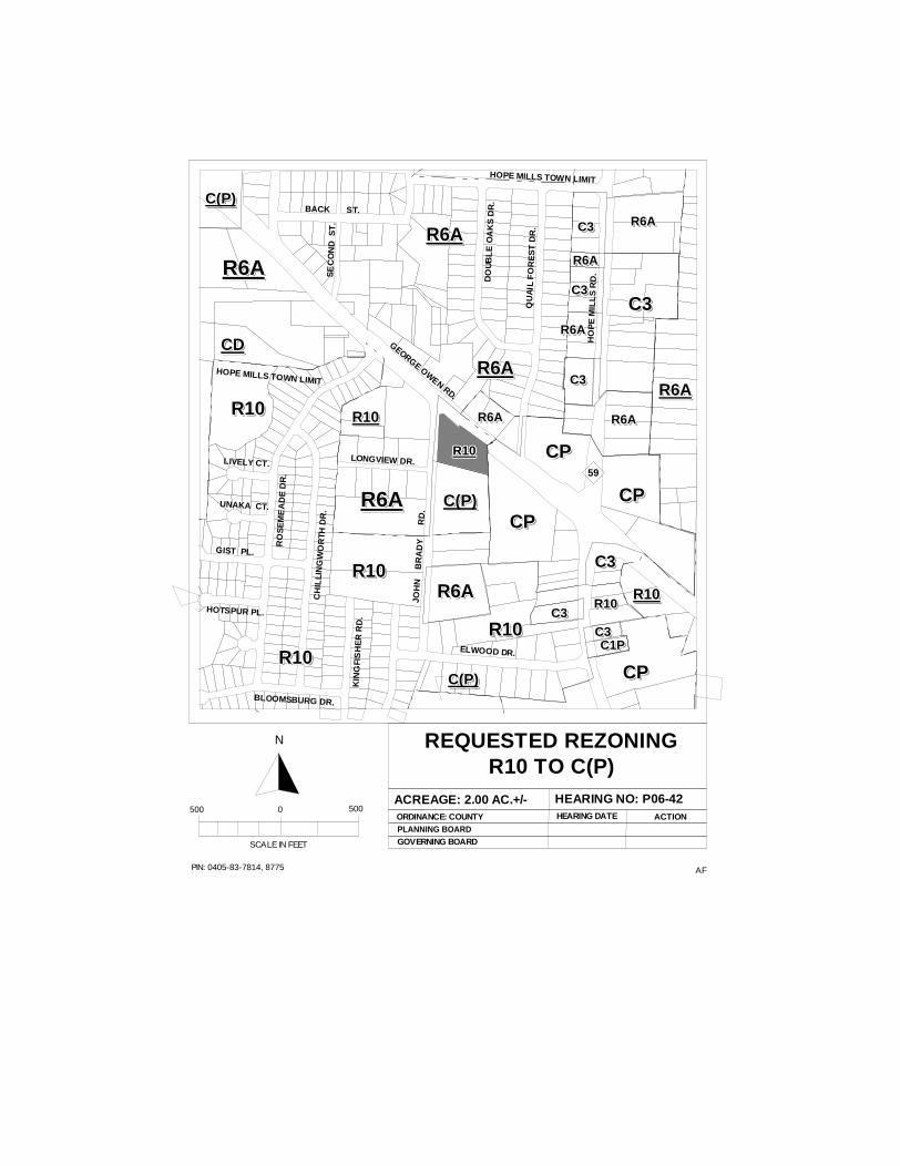
AFPIN: 0405-83-7814, 8775
REQUESTED REZONINGR10 TO C(P)
ACREAGE: 2.00 AC.+/- HEARING NO: P06-42ORDINANCE: COUNTYPLANNING BOARD
HEARING DATE ACTION
SCALE IN FEET
500 0 500
N
GOVERNING BOARD
R6AR6AR6AR6AR6AR6AR6AR6AR6AR6A
R6AR6AR6AR6AR6AR6AR6AR6AR6AR6A C(P)C(P)C(P)C(P)C(P)C(P)C(P)C(P)C(P)C(P)
R10R10R10R10R10R10R10R10R10R10
R10R10R10R10R10R10R10R10R10R10
C(P)C(P)C(P)C(P)C(P)C(P)C(P)C(P)C(P)C(P)
CDCDCDCDCDCDCDCDCDCD
R6AR6AR6AR6AR6AR6AR6AR6AR6AR6A
R10R10R10R10R10R10R10R10R10R10
C(P)C(P)C(P)C(P)C(P)C(P)C(P)C(P)C(P)C(P)
GEORGE OWEN RD.
ELWOOD DR.
CH
ILLI
NG
WO
RTH
DR
.
RO
SE
ME
AD
E D
R.
BLOOMSBURG DR.
LONGVIEW DR.
QU
AIL
FO
RE
ST
DR
.
DO
UB
LE
OA
KS
DR
.
HO
PE
MIL
LS
RD
.
JOH
N
BR
AD
Y
R
D.
C3C3C3C3C3C3C3C3C3C3
R6AR6AR6AR6AR6AR6AR6AR6AR6AR6A
C3C3C3C3C3C3C3C3C3C3
R6AR6AR6AR6AR6AR6AR6AR6AR6AR6A
C3C3C3C3C3C3C3C3C3C3
R6AR6AR6AR6AR6AR6AR6AR6AR6AR6A
C3C3C3C3C3C3C3C3C3C3
R6AR6AR6AR6AR6AR6AR6AR6AR6AR6A
R6AR6AR6AR6AR6AR6AR6AR6AR6AR6A
CPCPCPCPCPCPCPCPCPCP
CPCPCPCPCPCPCPCPCPCP
CPCPCPCPCPCPCPCPCPCP
R10R10R10R10R10R10R10R10R10R10
R10R10R10R10R10R10R10R10R10R10
R10R10R10R10R10R10R10R10R10R10
R6AR6AR6AR6AR6AR6AR6AR6AR6AR6A
R10R10R10R10R10R10R10R10R10R10C3C3C3C3C3C3C3C3C3C3
CPCPCPCPCPCPCPCPCPCP
R10R10R10R10R10R10R10R10R10R10
C1PC1PC1PC1PC1PC1PC1PC1PC1PC1PC3C3C3C3C3C3C3C3C3C3
C3C3C3C3C3C3C3C3C3C3
HOPE MILLS TOWN LIMIT
HOPE MILLS TOWN LIMIT
GIST PL.
HOTSPUR PL.
UNAKA CT.
LIVELY CT.
KIN
GFI
SH
ER
RD
.
R6AR6AR6AR6AR6AR6AR6AR6AR6AR6A
BACK ST.
SE
CO
ND
ST
.
R6AR6AR6AR6AR6AR6AR6AR6AR6AR6A
59
Charles C. Morris
Chair Town of Linden
Donovan McLaurin Vice-Chair
Wade, Falcon & Godwin Garland C. Hostetter, Town of Spring Lake
Harvey Cain, Jr., Town of Stedman
COUNTY of CUMBERLAND
Planning and Inspections Department
Thomas J. Lloyd, Director
Clifton McNeill, Jr., Roy Turner, Lori Epler,
Sara E. Piland, Cumberland County
June 13, 2006
MEMORANDUM
TO: Cumberland County Joint Planning Board
FROM: Planning & Inspections Staff
SUBJECT: Staff Recommendation for June 20, 2006 Board Meeting
P06-43: REZONING OF 2.0 ACRES FROM A1 TO R40A OR TO A MORE RESTRICTIVE ZONING DISTRICT, AT 7461 AND 7473 RUFUS JOHNSON ROAD, SUBMITTED BY TOMMY SMITH, OWNED BY CARRIAGE CROSSING, INC.
The Planning & Inspections Staff recommends approval of the R40A based on the following:
1. The request is consistent with the 2010 Land Use Plan; and
2. The request is reasonable considering the lot sizes in the general area.
Note: The Planning and Inspections Staff s preference would be for rezoning to A1A; however, one of the existing structures on the subject property is not a Class A manufactured home and would become nonconforming.
There are no other suitable districts to be considered for this site.
Attachments: 1 - Rezoning Sketch Map 2 - Site Profile
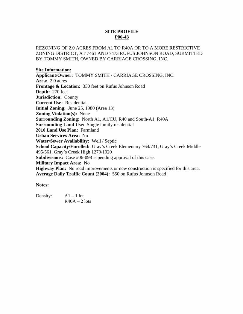
SITE PROFILE P06-43
REZONING OF 2.0 ACRES FROM A1 TO R40A OR TO A MORE RESTRICTIVE ZONING DISTRICT, AT 7461 AND 7473 RUFUS JOHNSON ROAD, SUBMITTED BY TOMMY SMITH, OWNED BY CARRIAGE CROSSING, INC.
Site Information:
Applicant/Owner: TOMMY SMITH / CARRIAGE CROSSING, INC. Area: 2.0 acres Frontage & Location: 330 feet on Rufus Johnson Road Depth: 270 feet Jurisdiction: County Current Use: Residential Initial Zoning: June 25, 1980 (Area 13) Zoning Violation(s): None Surrounding Zoning: North A1, A1/CU, R40 and South-A1, R40A Surrounding Land Use: Single family residential 2010 Land Use Plan: Farmland Urban Services Area: No Water/Sewer Availability: Well / Septic School Capacity/Enrolled: Gray s Creek Elementary 764/731, Gray s Creek Middle 495/561, Gray s Creek High 1270/1020 Subdivisions: Case #06-098 is pending approval of this case. Military Impact Area: No Highway Plan: No road improvements or new construction is specified for this area. Average Daily Traffic Count (2004): 550 on Rufus Johnson Road
Notes:
Density: A1 1 lot R40A 2 lots
AFPIN: 0339-48-2792
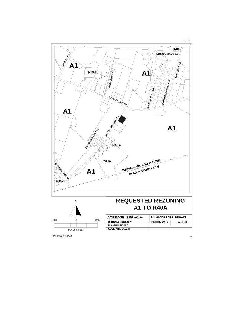
REQUESTED REZONINGA1 TO R40A
ACREAGE: 2.00 AC.+/- HEARING NO: P06-43ORDINANCE: COUNTYPLANNING BOARD
HEARING DATE ACTION
SCALE IN FEET
1000 0 1000
N
GOVERNING BOARD
A1A1A1A1A1A1A1A1A1A1
A1A1A1A1A1A1A1A1A1A1
A1A1A1A1A1A1A1A1A1A1
A1A1A1A1A1A1A1A1A1A1
A1/CUA1/CUA1/CUA1/CUA1/CUA1/CUA1/CUA1/CUA1/CUA1/CU
R40AR40AR40AR40AR40AR40AR40AR40AR40AR40A
R40AR40AR40AR40AR40AR40AR40AR40AR40AR40A
RU
FUS
JOH
NSO
N R
D.
COUNTY LINE RD.
DO
CUM
ENTA
RY
DR
.
GO
VE
RN
OR
S
LN
.
BLADEN COUNTY LINECUMBERLAND COUNTY LINE
HE
NR
Y S
MIT
H R
D.
R40R40R40R40R40R40R40R40R40R40
CHICKEN FOOT RD.
FIR
E D
EP
T. R
D.
CO
NG
RE
SS
ION
AL
AV
E.
RID
DLE
R
D.
R40AR40AR40AR40AR40AR40AR40AR40AR40AR40A
A1A1A1A1A1A1A1A1A1A1
INDEPENDENCE DR.
Charles C. Morris
Chair Town of Linden
Donovan McLaurin Vice-Chair
Wade, Falcon & Godwin Garland C. Hostetter, Town of Spring Lake
Harvey Cain, Jr., Town of Stedman
COUNTY of CUMBERLAND
Planning and Inspections Department
Thomas J. Lloyd, Director
Clifton McNeill, Jr., Roy Turner, Lori Epler,
Sara E. Piland, Cumberland County
June 13, 2006
MEMORANDUM
TO: Cumberland County Joint Planning Board
FROM: Planning & Inspections Staff
SUBJECT: Staff Recommendation for June 20, 2006 Board Meeting
P06-46: REZONING OF THREE PARCELS TOTALING 3.64 ACRES FROM R6A AND C3 TO C(P) OR TO A MORE RESTRICTIVE ZONING DISTRICT, LOCATED ON THE WEST SIDE OF MURCHISON ROAD, AND ON THE NORTH AND SOUTH SIDES OF BERNADINE STREET, SUBMITTED BY JIM MOHLER, OWNED BY 96 INVESTORS, INC.
The Planning & Inspections Staff recommends approval of the C(P) district based on the following:
1. The request is consistent with the 2010 Land Use Plan, calling for an Activity Node at this location; and
2. The subject property is located on a major thoroughfare; and
3. The C(P) district is in keeping with the current zoning within the area.
Other suitable zoning districts are O&I(P) and C1(P).
Attachments: 1 - Rezoning Sketch Map 2 - Site Profile
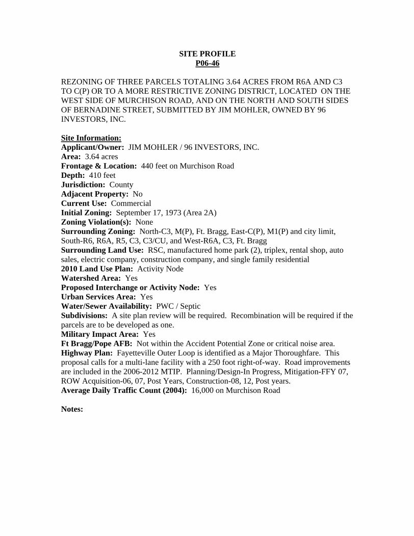
SITE PROFILE P06-46
REZONING OF THREE PARCELS TOTALING 3.64 ACRES FROM R6A AND C3 TO C(P) OR TO A MORE RESTRICTIVE ZONING DISTRICT, LOCATED ON THE WEST SIDE OF MURCHISON ROAD, AND ON THE NORTH AND SOUTH SIDES OF BERNADINE STREET, SUBMITTED BY JIM MOHLER, OWNED BY 96 INVESTORS, INC.
Site Information:
Applicant/Owner: JIM MOHLER / 96 INVESTORS, INC. Area: 3.64 acres Frontage & Location: 440 feet on Murchison Road Depth: 410 feet Jurisdiction: County Adjacent Property: No Current Use: Commercial Initial Zoning: September 17, 1973 (Area 2A) Zoning Violation(s): None Surrounding Zoning: North-C3, M(P), Ft. Bragg, East-C(P), M1(P) and city limit, South-R6, R6A, R5, C3, C3/CU, and West-R6A, C3, Ft. Bragg Surrounding Land Use: RSC, manufactured home park (2), triplex, rental shop, auto sales, electric company, construction company, and single family residential 2010 Land Use Plan: Activity Node Watershed Area: Yes Proposed Interchange or Activity Node: Yes Urban Services Area: Yes Water/Sewer Availability: PWC / Septic Subdivisions: A site plan review will be required. Recombination will be required if the parcels are to be developed as one. Military Impact Area: Yes Ft Bragg/Pope AFB: Not within the Accident Potential Zone or critical noise area. Highway Plan: Fayetteville Outer Loop is identified as a Major Thoroughfare. This proposal calls for a multi-lane facility with a 250 foot right-of-way. Road improvements are included in the 2006-2012 MTIP. Planning/Design-In Progress, Mitigation-FFY 07, ROW Acquisition-06, 07, Post Years, Construction-08, 12, Post years. Average Daily Traffic Count (2004): 16,000 on Murchison Road
Notes:
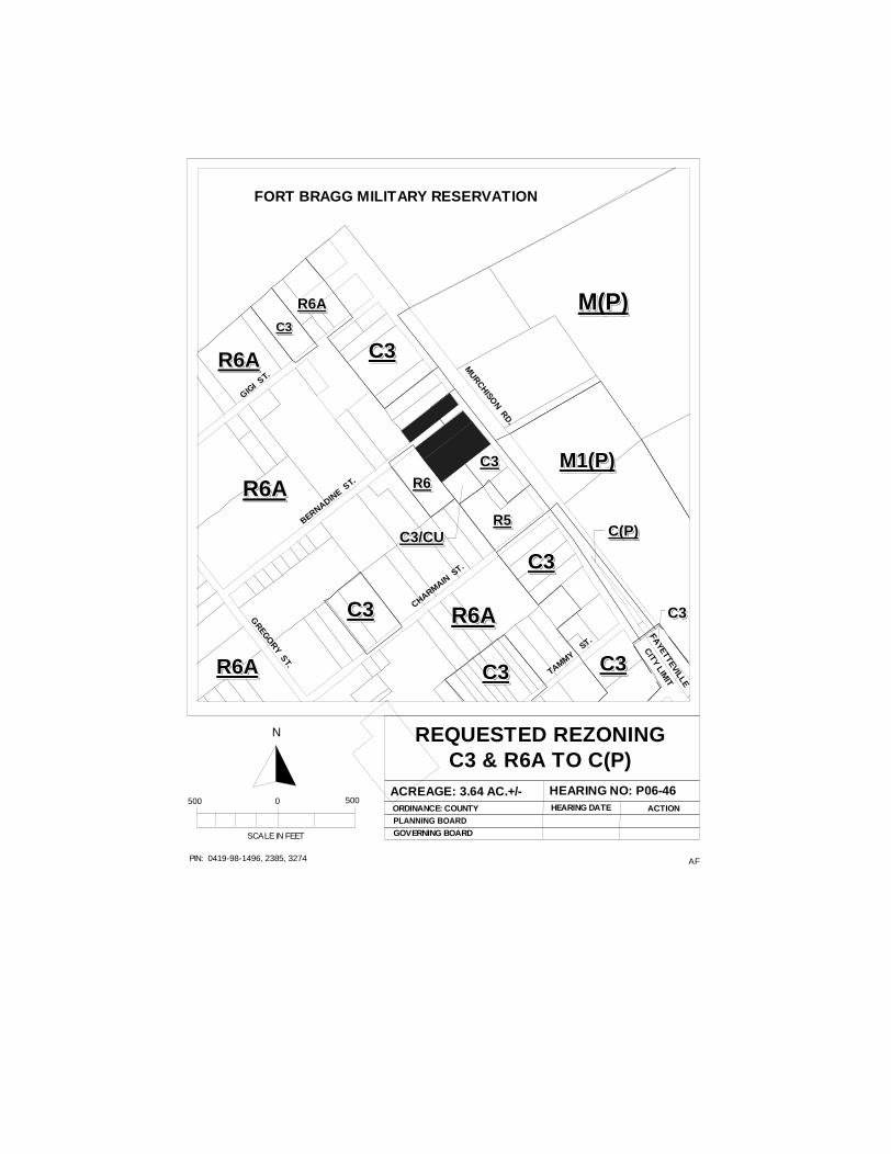
AFPIN: 0419-98-1496, 2385, 3274
REQUESTED REZONINGC3 & R6A TO C(P)
ACREAGE: 3.64 AC.+/- HEARING NO: P06-46ORDINANCE: COUNTYPLANNING BOARD
HEARING DATE ACTION
SCALE IN FEET
500 0 500
N
GOVERNING BOARD
M(P)M(P)M(P)M(P)M(P)M(P)M(P)M(P)M(P)M(P)
R6AR6AR6AR6AR6AR6AR6AR6AR6AR6A
C3C3C3C3C3C3C3C3C3C3
C3C3C3C3C3C3C3C3C3C3
C3C3C3C3C3C3C3C3C3C3
R6R6R6R6R6R6R6R6R6R6
C3C3C3C3C3C3C3C3C3C3
C3C3C3C3C3C3C3C3C3C3
C3C3C3C3C3C3C3C3C3C3
R5R5R5R5R5R5R5R5R5R5C3/CUC3/CUC3/CUC3/CUC3/CUC3/CUC3/CUC3/CUC3/CUC3/CU
C3C3C3C3C3C3C3C3C3C3
C(P)C(P)C(P)C(P)C(P)C(P)C(P)C(P)C(P)C(P)
FAYETTEVILLE
CITY LIM
IT
MURCHISO
N RD.
GIGI S
T.
BERNADINE S
T.
CHARMAIN S
T.
TAMMY ST.
FORT BRAGG MILITARY RESERVATION
R6AR6AR6AR6AR6AR6AR6AR6AR6AR6A
R6AR6AR6AR6AR6AR6AR6AR6AR6AR6A
GREGO
RY ST.
M1(P)M1(P)M1(P)M1(P)M1(P)M1(P)M1(P)M1(P)M1(P)M1(P)
R6AR6AR6AR6AR6AR6AR6AR6AR6AR6A
R6AR6AR6AR6AR6AR6AR6AR6AR6AR6A
C3C3C3C3C3C3C3C3C3C3
Charles C. Morris
Chair Town of Linden
Donovan McLaurin Vice-Chair
Wade, Falcon & Godwin Garland C. Hostetter, Town of Spring Lake
Harvey Cain, Jr., Town of Stedman
COUNTY of CUMBERLAND
Planning and Inspections Department
Thomas J. Lloyd, Director
Clifton McNeill, Jr., Roy Turner, Lori Epler,
Sara E. Piland, Cumberland County
June 13, 2006
MEMORANDUM
TO: Cumberland County Joint Planning Board
FROM: Planning & Inspections Staff
SUBJECT: Staff Recommendation for June 20, 2006 Board Meeting
P06-48: REZONING OF 1.87 ACRES FROM R6 TO C1 OR TO A MORE RESTRICTIVE ZONING DISTRICT, AT 230 CHAPEL HILL ROAD, SUBMITTED BY AMMIE M. JENKINS, OWNED BY SANDHILLS FAMILY HERITAGE ASSOCIATION. (SPRING LAKE)
The Planning & Inspections Staff recommends approval of the C1 district based on the following:
1. Although the request is not consistent with the Spring Lake Area Detailed Land Use Plan, the request is consistent with the character of the neighborhood; and
2. Approval of the request would allow for the use of the vacant non-residential structure on the site.
3. Town of Spring Lake water and sewer are available to the site.
The O&I zoning district is the only other suitable district.
Attachments: 1 - Rezoning Sketch Map 2 - Site Profile
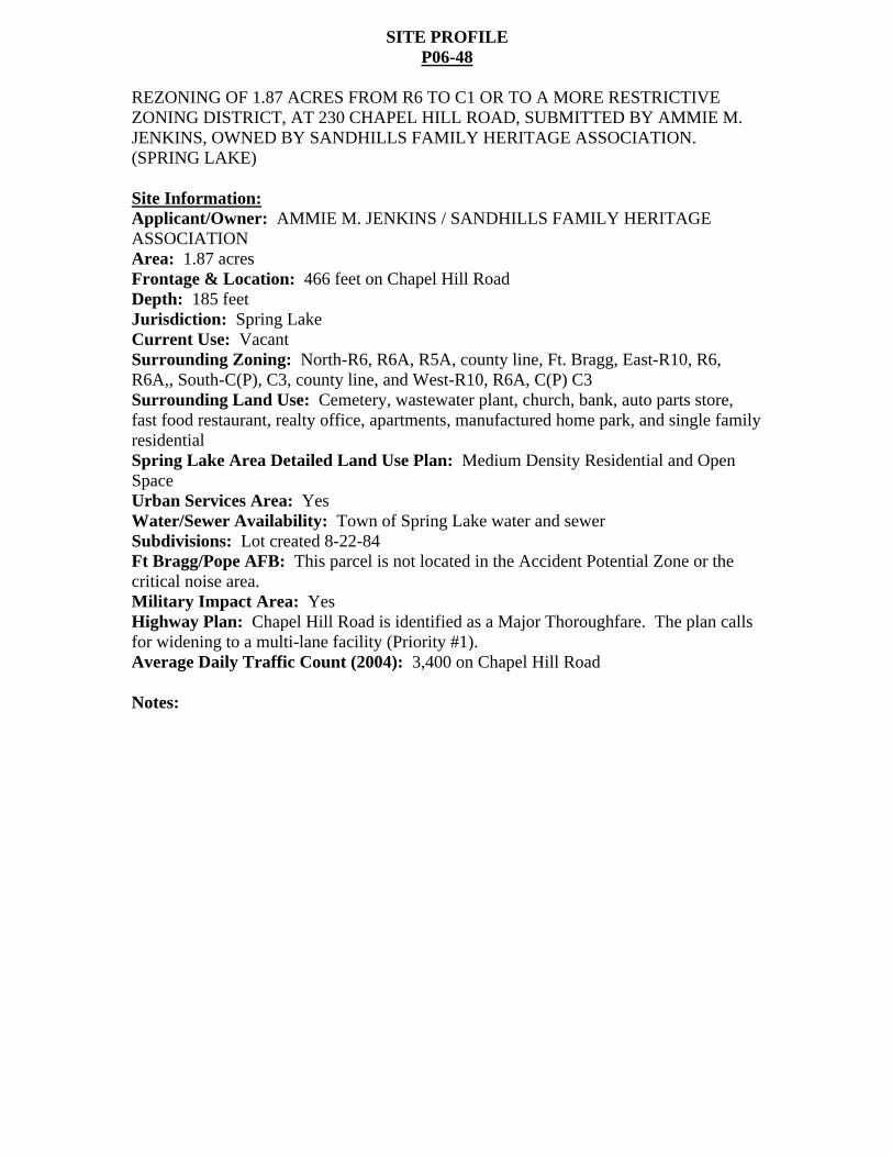
SITE PROFILE P06-48
REZONING OF 1.87 ACRES FROM R6 TO C1 OR TO A MORE RESTRICTIVE ZONING DISTRICT, AT 230 CHAPEL HILL ROAD, SUBMITTED BY AMMIE M. JENKINS, OWNED BY SANDHILLS FAMILY HERITAGE ASSOCIATION. (SPRING LAKE)
Site Information:
Applicant/Owner: AMMIE M. JENKINS / SANDHILLS FAMILY HERITAGE ASSOCIATION Area: 1.87 acres Frontage & Location: 466 feet on Chapel Hill Road Depth: 185 feet Jurisdiction: Spring Lake Current Use: Vacant Surrounding Zoning: North-R6, R6A, R5A, county line, Ft. Bragg, East-R10, R6, R6A,, South-C(P), C3, county line, and West-R10, R6A, C(P) C3 Surrounding Land Use: Cemetery, wastewater plant, church, bank, auto parts store, fast food restaurant, realty office, apartments, manufactured home park, and single family residential Spring Lake Area Detailed Land Use Plan: Medium Density Residential and Open Space Urban Services Area: Yes Water/Sewer Availability: Town of Spring Lake water and sewer Subdivisions: Lot created 8-22-84 Ft Bragg/Pope AFB: This parcel is not located in the Accident Potential Zone or the critical noise area. Military Impact Area: Yes Highway Plan: Chapel Hill Road is identified as a Major Thoroughfare. The plan calls for widening to a multi-lane facility (Priority #1). Average Daily Traffic Count (2004): 3,400 on Chapel Hill Road
Notes:
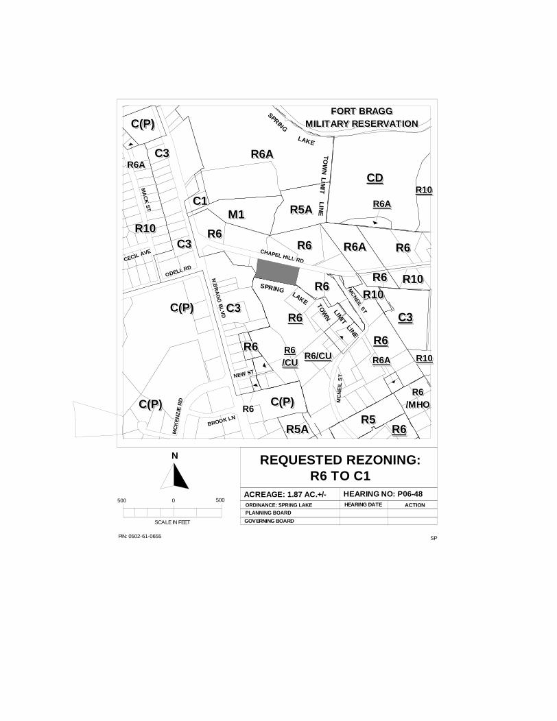
SPPIN: 0502-61-0655
REQUESTED REZONING:R6 TO C1
ACREAGE: 1.87 AC.+/- HEARING NO: P06-48ORDINANCE: SPRING LAKEPLANNING BOARD
GOVERNING BOARD
HEARING DATE ACTION
SCALE IN FEET
500 0 500
N
R6R6R6R6R6R6R6R6R6R6
R6/CUR6/CUR6/CUR6/CUR6/CUR6/CUR6/CUR6/CUR6/CUR6/CU
C3C3C3C3C3C3C3C3C3C3
R6AR6AR6AR6AR6AR6AR6AR6AR6AR6A
R6R6R6R6R6R6R6R6R6R6
R6AR6AR6AR6AR6AR6AR6AR6AR6AR6A
CDCDCDCDCDCDCDCDCDCDR10R10R10R10R10R10R10R10R10R10
FORT BRAGGFORT BRAGGFORT BRAGGFORT BRAGGFORT BRAGGFORT BRAGGFORT BRAGGFORT BRAGGFORT BRAGGFORT BRAGGMILITARY RESERVATIONMILITARY RESERVATIONMILITARY RESERVATIONMILITARY RESERVATIONMILITARY RESERVATIONMILITARY RESERVATIONMILITARY RESERVATIONMILITARY RESERVATIONMILITARY RESERVATIONMILITARY RESERVATION
R10R10R10R10R10R10R10R10R10R10
R5R5R5R5R5R5R5R5R5R5R5AR5AR5AR5AR5AR5AR5AR5AR5AR5A
R6R6R6R6R6R6R6R6R6R6
C3C3C3C3C3C3C3C3C3C3
C(P)C(P)C(P)C(P)C(P)C(P)C(P)C(P)C(P)C(P)
C(P)C(P)C(P)C(P)C(P)C(P)C(P)C(P)C(P)C(P)
C1C1C1C1C1C1C1C1C1C1M1M1M1M1M1M1M1M1M1M1 R5AR5AR5AR5AR5AR5AR5AR5AR5AR5A
R6AR6AR6AR6AR6AR6AR6AR6AR6AR6A
R6R6R6R6R6R6R6R6R6R6
R10R10R10R10R10R10R10R10R10R10
R6R6R6R6R6R6R6R6R6R6/MHO/MHO/MHO/MHO/MHO/MHO/MHO/MHO/MHO/MHO
R6AR6AR6AR6AR6AR6AR6AR6AR6AR6A
R10R10R10R10R10R10R10R10R10R10
C3C3C3C3C3C3C3C3C3C3
C3C3C3C3C3C3C3C3C3C3
C(P)C(P)C(P)C(P)C(P)C(P)C(P)C(P)C(P)C(P)
C(P)C(P)C(P)C(P)C(P)C(P)C(P)C(P)C(P)C(P)
R6R6R6R6R6R6R6R6R6R6
R6AR6AR6AR6AR6AR6AR6AR6AR6AR6A
R6R6R6R6R6R6R6R6R6R6
R10R10R10R10R10R10R10R10R10R10
R6R6R6R6R6R6R6R6R6R6R6R6R6R6R6R6R6R6R6R6
R6R6R6R6R6R6R6R6R6R6/CU/CU/CU/CU/CU/CU/CU/CU/CU/CU
R6R6R6R6R6R6R6R6R6
CHAPEL HILL RD
CHAPEL HILL RD
CHAPEL HILL RD
CHAPEL HILL RD
CHAPEL HILL RD
CHAPEL HILL RD
CHAPEL HILL RD
CHAPEL HILL RD
CHAPEL HILL RD
MC
NEIL S
T
MC
NEIL S
T
MC
NEIL S
T
MC
NEIL S
T
MC
NEIL S
T
MC
NEIL S
T
MC
NEIL S
T
MC
NEIL S
T
MC
NEIL S
T
NEW STNEW STNEW STNEW STNEW STNEW STNEW STNEW STNEW ST
N B
RA
GG
BL
VD
N B
RA
GG
BL
VD
N B
RA
GG
BL
VD
N B
RA
GG
BL
VD
N B
RA
GG
BL
VD
N B
RA
GG
BL
VD
N B
RA
GG
BL
VD
N B
RA
GG
BL
VD
N B
RA
GG
BL
VD
ODELL RDODELL RDODELL RDODELL RD
ODELL RDODELL RDODELL RDODELL RDODELL RD
MA
CK
ST
MA
CK
ST
MA
CK
ST
MA
CK
ST
MA
CK
ST
MA
CK
ST
MA
CK
ST
MA
CK
ST
MA
CK
ST
CECIL AVE
CECIL AVE
CECIL AVECECIL AVE
CECIL AVECECIL AVE
CECIL AVE
CECIL AVECECIL AVE
MC
NE
IL S
TM
CN
EIL
ST
MC
NE
IL S
TM
CN
EIL
ST
MC
NE
IL S
TM
CN
EIL
ST
MC
NE
IL S
TM
CN
EIL
ST
MC
NE
IL S
T
MC
KE
NZ
IE R
DM
CK
EN
ZIE
RD
MC
KE
NZ
IE R
DM
CK
EN
ZIE
RD
MC
KE
NZ
IE R
DM
CK
EN
ZIE
RD
MC
KE
NZ
IE R
DM
CK
EN
ZIE
RD
MC
KE
NZ
IE R
D
BROOK LNBROOK LNBROOK LNBROOK LNBROOK LNBROOK LNBROOK LNBROOK LNBROOK LN
SPRING
SPRING
SPRING
SPRING
SPRING
SPRING
SPRING
SPRING
SPRING
LAKELAKELAKELAKELAKELAKELAKELAKELAKE
TO
WN
TO
WN
TO
WN
TO
WN
TO
WN
TO
WN
TO
WN
TO
WN
TO
WN
LIM
ITL
IMIT
LIM
ITL
IMIT
LIM
ITL
IMIT
LIM
ITL
IMIT
LIM
ITL
INE
LIN
EL
INE
LIN
EL
INE
LIN
EL
INE
LIN
EL
INE
SPRINGSPRINGSPRINGSPRINGSPRINGSPRINGSPRINGSPRINGSPRING LAKE
LAKELAKELAKELAKELAKELAKELAKELAKE TO
WN
TOW
NTO
WN
TOW
NTO
WN
TOW
NTO
WN
TOW
NTO
WN
LIMIT
LIMIT
LIMIT
LIMIT
LIMIT
LIMIT
LIMIT
LIMIT
LIMIT
LINELINELINELINELINELINELINELINELINE
R6R6R6R6R6R6R6R6R6R6
Charles C. Morris
Chair Town of Linden
Donovan McLaurin Vice-Chair
Wade, Falcon & Godwin Garland C. Hostetter, Town of Spring Lake
Harvey Cain, Jr., Town of Stedman
COUNTY of CUMBERLAND
Planning and Inspections Department
Thomas J. Lloyd, Director
Clifton McNeill, Jr., Roy Turner, Lori Epler,
Sara E. Piland, Cumberland County
June 13, 2006
MEMORANDUM
TO: Cumberland County Joint Planning Board
FROM: Planning & Inspections Staff
SUBJECT: Staff Recommendation for June 20, 2006 Board Meeting
P06-33: REVISION AND AMENDMENT TO THE CUMBERLAND COUNTY ZONING ORDINANCE, BY AMENDING ARTICLE IV. PERMITTED, CONDITIONAL, AND SPECIAL USES, SECTION 403 USE MATRIX, TO ALLOW SINGLE FAMILY DWELLING TO BE PERMITTED ON THE SECOND FLOOR AND ABOVE FOR COMMERCIAL, RETAIL AND OFFICE SPACE IN THE C(P) DISTRICT, SUBMITTED BY BRADLEY W. YOUNG.
This request for consideration of a text amendment was deferred from the May 16, 2006 at the applicant s request. The Planning & Inspections Staff recommended denial of the proposed amendment as submitted. The Staff did agree that with some minimum standards in place in the Ordinance, allowing residential dwellings on the second floor or above could be a viable use of properties in the commercial districts.
The Planning & Inspections Staff recommends approval of the request if the Board favorably considers recommending adoption of the attached standards (text amendment) affecting Article II (Definitions), Article IV (Use Matrix), and Article IX (Individual Uses). This recommendation has been forwarded to the applicant.
Attachments: 1. Staff Recommended Text Amendment 2. Applicant s Recommended Text Amendment
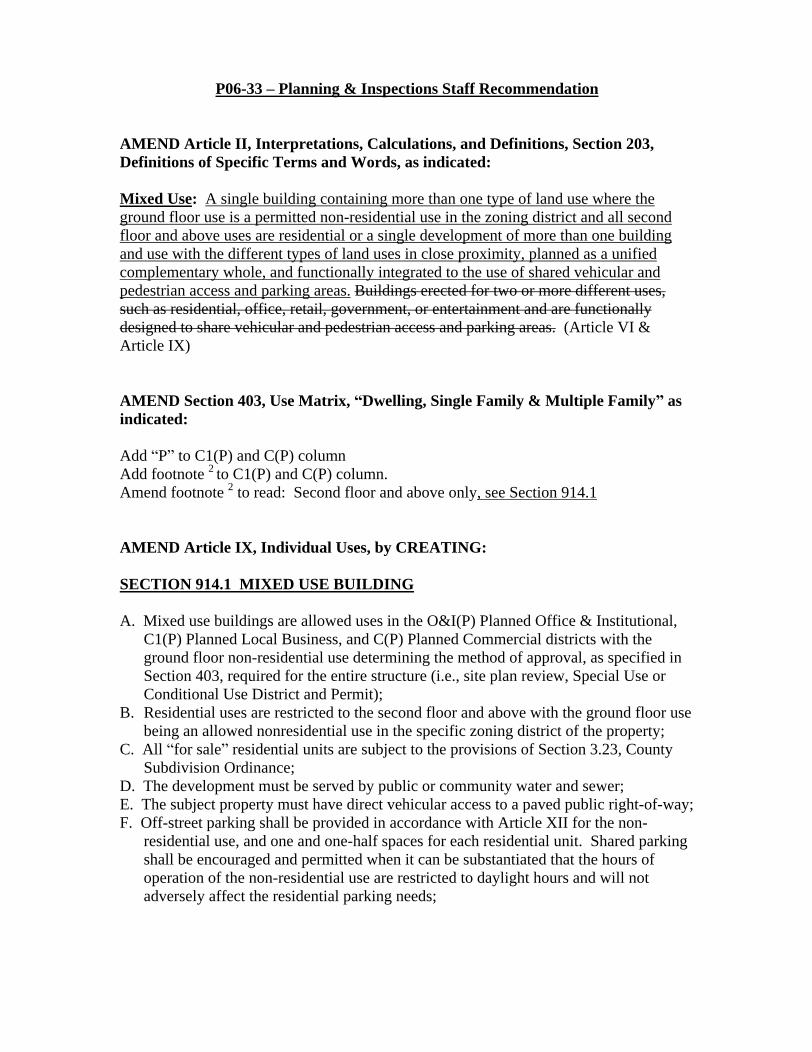
P06-33 Planning & Inspections Staff Recommendation
AMEND Article II, Interpretations, Calculations, and Definitions, Section 203, Definitions of Specific Terms and Words, as indicated:
Mixed Use: A single building containing more than one type of land use where the ground floor use is a permitted non-residential use in the zoning district and all second floor and above uses are residential or a single development of more than one building and use with the different types of land uses in close proximity, planned as a unified complementary whole, and functionally integrated to the use of shared vehicular and pedestrian access and parking areas.
Buildings erected for two or more different uses, such as residential, office, retail, government, or entertainment and are functionally designed to share vehicular and pedestrian access and parking areas. (Article VI & Article IX)
AMEND Section 403, Use Matrix, Dwelling, Single Family & Multiple Family as indicated:
Add P to C1(P) and C(P) column Add footnote 2 to C1(P) and C(P) column. Amend footnote 2 to read: Second floor and above only, see Section 914.1
AMEND Article IX, Individual Uses, by CREATING:
SECTION 914.1 MIXED USE BUILDING
A. Mixed use buildings are allowed uses in the O&I(P) Planned Office & Institutional, C1(P) Planned Local Business, and C(P) Planned Commercial districts with the ground floor non-residential use determining the method of approval, as specified in Section 403, required for the entire structure (i.e., site plan review, Special Use or Conditional Use District and Permit);
B. Residential uses are restricted to the second floor and above with the ground floor use being an allowed nonresidential use in the specific zoning district of the property;
C. All for sale residential units are subject to the provisions of Section 3.23, County Subdivision Ordinance;
D. The development must be served by public or community water and sewer; E. The subject property must have direct vehicular access to a paved public right-of-way; F. Off-street parking shall be provided in accordance with Article XII for the non-
residential use, and one and one-half spaces for each residential unit. Shared parking shall be encouraged and permitted when it can be substantiated that the hours of operation of the non-residential use are restricted to daylight hours and will not adversely affect the residential parking needs;

G. The minimum lot area per residential unit shall be 1,000 square feet not including the
lot area utilized by the non-residential use. The site plan must provide the calculations indicating compliance with this provision;
H. Sidewalks are required in accordance with the standards of the County Subdivision Ordinance;
H. A fee in lieu of dedication or on-site parks, recreation, and open space is mandatory. This fee is to be calculated in the same manner as established in Section 3.13.1, County Subdivision Ordinance.

P06-33
REVISION AND AMENDMENT TO THE CUMBERLAND COUNTY ZONING ORDINANCE, BY AMENDING ARTICLE IV. PERMITTED, CONDITIONAL, AND SPECIAL USES, SECTION 403 USE MATRIX, TO ALLOW SINGLE FAMILY DWELLING TO BE PERMITTED ON THE SECOND FLOOR AND ABOVE FOR COMMERCIAL, RETAIL AND OFFICE SPACE IN THE C(P) DISTRICT, SUBMITTED BY BRADLEY W. YOUNG.
AMEND Article IV, Permitted, Conditional, and Special Uses, Section 403, Use Matrix, by INSERTING P in the C(P) column to allow Single Family Dwelling to be permitted on the second floor and above for commercial, retail, and office space.
Charles C. Morris
Chair Town of Linden
Donovan McLaurin Vice-Chair
Wade, Falcon & Godwin Garland C. Hostetter, Town of Spring Lake
Harvey Cain, Jr., Town of Stedman
COUNTY of CUMBERLAND
Planning and Inspections Department
Thomas J. Lloyd, Director
Clifton McNeill, Jr., Roy Turner, Lori Epler,
Sara E. Piland, Cumberland County
June 13, 2006
MEMORANDUM
TO: Cumberland County Joint Planning Board
FROM: Planning & Inspections Staff
SUBJECT: Staff Recommendation for June 20, 2006 Board Meeting
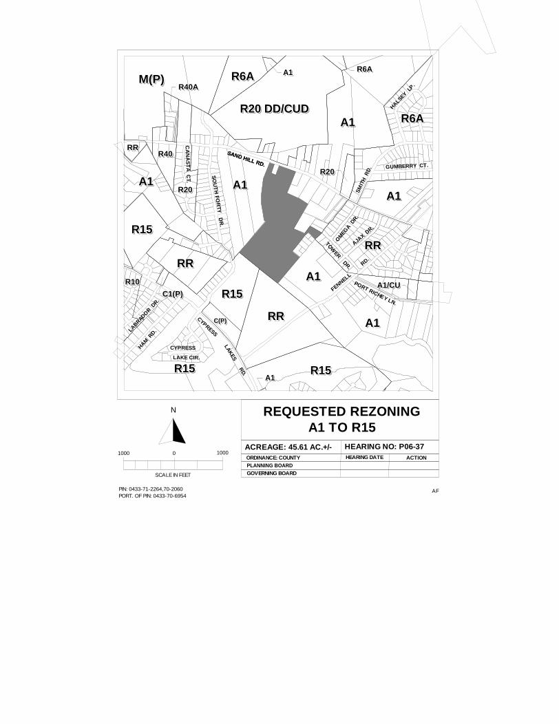
P06-37: REZONING OF THREE PARCELS TOTALING 45.61 ACRES FROM A1 TO R15 OR TO A MORE RESTRICTIVE ZONING DISTRICT, SOUTH OF SAND HILL ROAD, WEST OF TOWER ROAD, SUBMITTED BY CHRISTOPHER ROBERTS, OWNED BY JAMES BUXTON, ANNIE M. FREEMAN, AND THELMA BATTLE.
The Planning & Inspections Staff recommended denial of the R15 and approval of R20 zoning district even though the recommendation is not consistent with the 2010 Land Use Plan at the May 16, 2006 meeting and the recommendation has not changed. This recommendation is based on the following:
1. The R20 district is consistent with the current land use and development in the area; and
2. The R20 district is consistent with previous rezoning classifications in the area.
The other suitable zoning districts to be considered for this site are R40, R40A, R30, R30A, R20, and RR
Attachments: 1 - Rezoning Sketch Map 2 - Site Profile
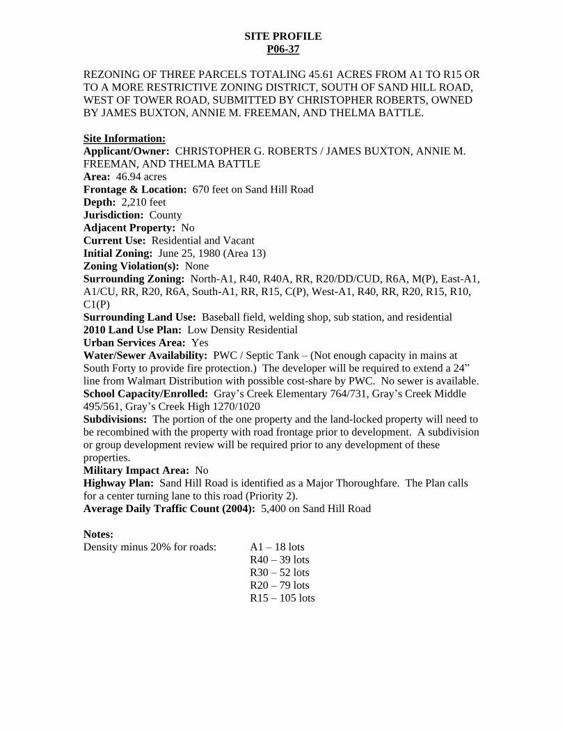
SITE PROFILE
P06-37
REZONING OF THREE PARCELS TOTALING 45.61 ACRES FROM A1 TO R15 OR TO A MORE RESTRICTIVE ZONING DISTRICT, SOUTH OF SAND HILL ROAD, WEST OF TOWER ROAD, SUBMITTED BY CHRISTOPHER ROBERTS, OWNED BY JAMES BUXTON, ANNIE M. FREEMAN, AND THELMA BATTLE.
Site Information:
Applicant/Owner: CHRISTOPHER G. ROBERTS / JAMES BUXTON, ANNIE M. FREEMAN, AND THELMA BATTLE Area: 46.94 acres Frontage & Location: 670 feet on Sand Hill Road Depth: 2,210 feet Jurisdiction: County Adjacent Property: No Current Use: Residential and Vacant Initial Zoning: June 25, 1980 (Area 13) Zoning Violation(s): None Surrounding Zoning: North-A1, R40, R40A, RR, R20/DD/CUD, R6A, M(P), East-A1, A1/CU, RR, R20, R6A, South-A1, RR, R15, C(P), West-A1, R40, RR, R20, R15, R10, C1(P) Surrounding Land Use: Baseball field, welding shop, sub station, and residential 2010 Land Use Plan: Low Density Residential Urban Services Area: Yes Water/Sewer Availability: PWC / Septic Tank (Not enough capacity in mains at South Forty to provide fire protection.) The developer will be required to extend a 24 line from Walmart Distribution with possible cost-share by PWC. No sewer is available. School Capacity/Enrolled: Gray s Creek Elementary 764/731, Gray s Creek Middle 495/561, Gray s Creek High 1270/1020 Subdivisions: The portion of the one property and the land-locked property will need to be recombined with the property with road frontage prior to development. A subdivision or group development review will be required prior to any development of these properties. Military Impact Area: No Highway Plan: Sand Hill Road is identified as a Major Thoroughfare. The Plan calls for a center turning lane to this road (Priority 2). Average Daily Traffic Count (2004): 5,400 on Sand Hill Road
Notes: Density minus 20% for roads: A1 18 lots
R40 39 lots R30 52 lots R20 79 lots R15 105 lots
AFPIN: 0433-71-2264,70-2060PORT. OF PIN: 0433-70-6954
REQUESTED REZONINGA1 TO R15
ACREAGE: 45.61 AC.+/- HEARING NO: P06-37ORDINANCE: COUNTYPLANNING BOARD
HEARING DATE ACTION
SCALE IN FEET
1000 0 1000
N
GOVERNING BOARD
R20 DD/CUDR20 DD/CUDR20 DD/CUDR20 DD/CUDR20 DD/CUDR20 DD/CUDR20 DD/CUDR20 DD/CUDR20 DD/CUDR20 DD/CUD
A1A1A1A1A1A1A1A1A1A1
A1A1A1A1A1A1A1A1A1A1
R6AR6AR6AR6AR6AR6AR6AR6AR6AR6AM(P)M(P)M(P)M(P)M(P)M(P)M(P)M(P)M(P)M(P)
R15R15R15R15R15R15R15R15R15R15
RRRRRRRRRRRRRRRRRRRR
RRRRRRRRRRRRRRRRRRRR
R15R15R15R15R15R15R15R15R15R15
RRRRRRRRRRRRRRRRRRRR
R6AR6AR6AR6AR6AR6AR6AR6AR6AR6A
R10R10R10R10R10R10R10R10R10R10
A1A1A1A1A1A1A1A1A1A1
A1A1A1A1A1A1A1A1A1A1
R20R20R20R20R20R20R20R20R20R20
R20R20R20R20R20R20R20R20R20R20
C(P)C(P)C(P)C(P)C(P)C(P)C(P)C(P)C(P)C(P)
C1(P)C1(P)C1(P)C1(P)C1(P)C1(P)C1(P)C1(P)C1(P)C1(P)
R15R15R15R15R15R15R15R15R15R15
A1A1A1A1A1A1A1A1A1A1
A1/CUA1/CUA1/CUA1/CUA1/CUA1/CUA1/CUA1/CUA1/CUA1/CU
A1A1A1A1A1A1A1A1A1A1
R40R40R40R40R40R40R40R40R40R40R40R40R40R40R40R40R40R40R40R40
R40AR40AR40AR40AR40AR40AR40AR40AR40AR40A
RRRRRRRRRRRRRRRRRRRRSAND HILL RD.
SAND HILL RD.
SO
UT
H FO
RTY
DR
.
CYPRESSLA
KES R
D.
FENNELL
RD.
OM
EGA D
R.
AJAX D
R.
SMIT
H R
D. GUMBERRY CT.
HAM R
D.LABRADOR D
R.
CA
NA
ST
A C
T.
R6AR6AR6AR6AR6AR6AR6AR6AR6AR6AA1A1A1A1A1A1A1A1A1A1
HALSEY LP.
PORT RICHEY LN.R15R15R15R15R15R15R15R15R15R15
A1A1A1A1A1A1A1A1A1A1
CYPRESS
LAKE CIR.
TOWER DR.
Charles C. Morris
Chair Town of Linden
Donovan McLaurin Vice-Chair
Wade, Falcon & Godwin Garland C. Hostetter, Town of Spring Lake
Harvey Cain, Jr., Town of Stedman
COUNTY of CUMBERLAND
Planning and Inspections Department
Thomas J. Lloyd, Director
Clifton McNeill, Jr., Roy Turner, Lori Epler,
Sara E. Piland, Cumberland County
June 13, 2006
MEMORANDUM
TO: Cumberland County Joint Planning Board
FROM: Planning & Inspections Staff
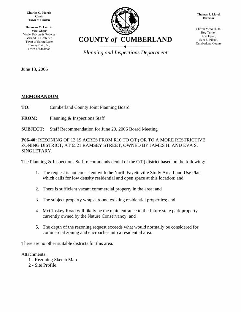
SUBJECT: Staff Recommendation for June 20, 2006 Board Meeting
P06-40: REZONING OF 13.19 ACRES FROM R10 TO C(P) OR TO A MORE RESTRICTIVE ZONING DISTRICT, AT 6521 RAMSEY STREET, OWNED BY JAMES H. AND EVA S. SINGLETARY.
The Planning & Inspections Staff recommends denial of the C(P) district based on the following:
1. The request is not consistent with the North Fayetteville Study Area Land Use Plan which calls for low density residential and open space at this location; and
2. There is sufficient vacant commercial property in the area; and
3. The subject property wraps around existing residential properties; and
4. McCloskey Road will likely be the main entrance to the future state park property currently owned by the Nature Conservancy; and
5. The depth of the rezoning request exceeds what would normally be considered for commercial zoning and encroaches into a residential area.
There are no other suitable districts for this area.
Attachments: 1 - Rezoning Sketch Map 2 - Site Profile
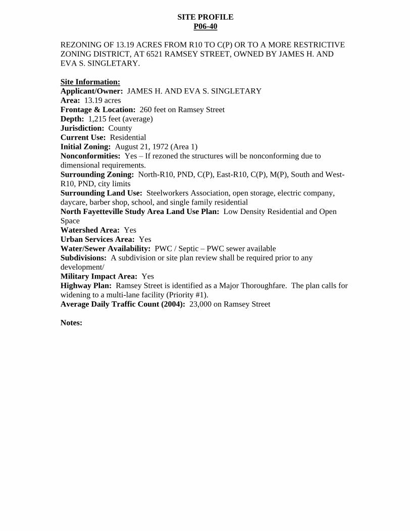
SITE PROFILE P06-40
REZONING OF 13.19 ACRES FROM R10 TO C(P) OR TO A MORE RESTRICTIVE ZONING DISTRICT, AT 6521 RAMSEY STREET, OWNED BY JAMES H. AND EVA S. SINGLETARY.
Site Information:
Applicant/Owner: JAMES H. AND EVA S. SINGLETARY Area: 13.19 acres Frontage & Location: 260 feet on Ramsey Street Depth: 1,215 feet (average) Jurisdiction: County Current Use: Residential Initial Zoning: August 21, 1972 (Area 1) Nonconformities: Yes If rezoned the structures will be nonconforming due to dimensional requirements. Surrounding Zoning: North-R10, PND, C(P), East-R10, C(P), M(P), South and West-R10, PND, city limits Surrounding Land Use: Steelworkers Association, open storage, electric company, daycare, barber shop, school, and single family residential North Fayetteville Study Area Land Use Plan: Low Density Residential and Open Space Watershed Area: Yes Urban Services Area: Yes Water/Sewer Availability: PWC / Septic PWC sewer available Subdivisions: A subdivision or site plan review shall be required prior to any development/ Military Impact Area: Yes Highway Plan: Ramsey Street is identified as a Major Thoroughfare. The plan calls for widening to a multi-lane facility (Priority #1). Average Daily Traffic Count (2004): 23,000 on Ramsey Street
Notes:
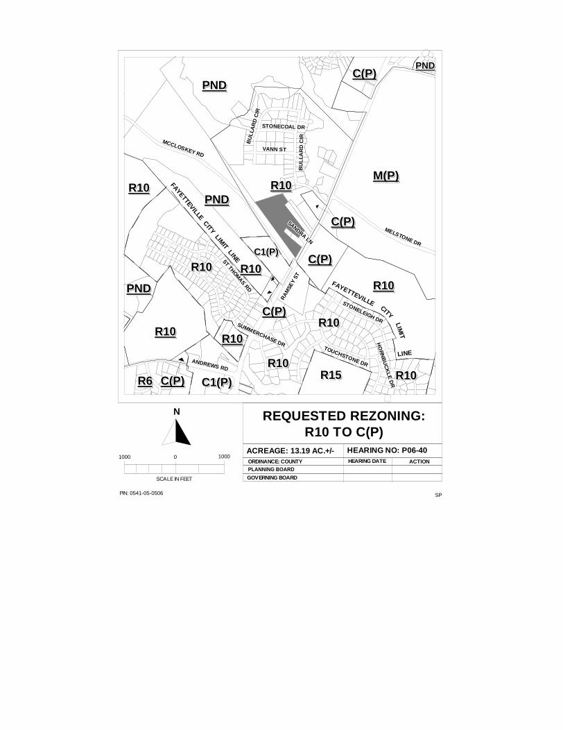
SPPIN: 0541-05-0506
REQUESTED REZONING:R10 TO C(P)
ACREAGE: 13.19 AC.+/- HEARING NO: P06-40ORDINANCE: COUNTYPLANNING BOARD
GOVERNING BOARD
HEARING DATE ACTION
SCALE IN FEET
1000 0 1000
N
BU
LLA
RD
CIR
BU
LLA
RD
CIR
BU
LLA
RD
CIR
BU
LLA
RD
CIR
BU
LLA
RD
CIR
BU
LLA
RD
CIR
BU
LLA
RD
CIR
BU
LLA
RD
CIR
BU
LLA
RD
CIR
STONECOAL DRSTONECOAL DRSTONECOAL DRSTONECOAL DRSTONECOAL DRSTONECOAL DRSTONECOAL DRSTONECOAL DRSTONECOAL DR
VANN STVANN STVANN STVANN STVANN STVANN STVANN STVANN STVANN ST
BU
LLA
RD
CIR
BU
LLA
RD
CIR
BU
LLA
RD
CIR
BU
LLA
RD
CIR
BU
LLA
RD
CIR
BU
LLA
RD
CIR
BU
LLA
RD
CIR
BU
LLA
RD
CIR
BU
LLA
RD
CIR
SANDRA LN
SANDRA LN
SANDRA LN
SANDRA LN
SANDRA LN
SANDRA LN
SANDRA LN
SANDRA LN
SANDRA LN
MELSTONE DR
MELSTONE DR
MELSTONE DR
MELSTONE DR
MELSTONE DR
MELSTONE DR
MELSTONE DR
MELSTONE DR
MELSTONE DR
STONELEIGH DR
STONELEIGH DR
STONELEIGH DR
STONELEIGH DR
STONELEIGH DR
STONELEIGH DR
STONELEIGH DR
STONELEIGH DR
STONELEIGH DR
HO
RN
BU
CK
LE
DR
HO
RN
BU
CK
LE
DR
HO
RN
BU
CK
LE
DR
HO
RN
BU
CK
LE
DR
HO
RN
BU
CK
LE
DR
HO
RN
BU
CK
LE
DR
HO
RN
BU
CK
LE
DR
HO
RN
BU
CK
LE
DR
HO
RN
BU
CK
LE
DR
TOUCHSTONE DR
TOUCHSTONE DR
TOUCHSTONE DR
TOUCHSTONE DR
TOUCHSTONE DR
TOUCHSTONE DR
TOUCHSTONE DR
TOUCHSTONE DR
TOUCHSTONE DR
SUMMERCHASE DR
SUMMERCHASE DR
SUMMERCHASE DR
SUMMERCHASE DR
SUMMERCHASE DR
SUMMERCHASE DR
SUMMERCHASE DR
SUMMERCHASE DR
SUMMERCHASE DRST THOM
AS RD
ST THOMAS RD
ST THOMAS RD
ST THOMAS RD
ST THOMAS RD
ST THOMAS RD
ST THOMAS RD
ST THOMAS RD
ST THOMAS RD
RA
MSE
Y ST
RA
MSE
Y ST
RA
MSE
Y ST
RA
MSE
Y ST
RA
MSE
Y ST
RA
MSE
Y ST
RA
MSE
Y ST
RA
MSE
Y ST
RA
MSE
Y ST
ANDREWS RDANDREWS RDANDREWS RD
ANDREWS RDANDREWS RD
ANDREWS RDANDREWS RDANDREWS RD
ANDREWS RD
MCCLOSKEY RD
MCCLOSKEY RD
MCCLOSKEY RD
MCCLOSKEY RD
MCCLOSKEY RD
MCCLOSKEY RD
MCCLOSKEY RD
MCCLOSKEY RD
MCCLOSKEY RD
R15R15R15R15R15R15R15R15R15R15
R10R10R10R10R10R10R10R10R10R10
C(P)C(P)C(P)C(P)C(P)C(P)C(P)C(P)C(P)C(P)
R10R10R10R10R10R10R10R10R10R10
R10R10R10R10R10R10R10R10R10R10
R10R10R10R10R10R10R10R10R10R10
C(P)C(P)C(P)C(P)C(P)C(P)C(P)C(P)C(P)C(P)
R10R10R10R10R10R10R10R10R10R10
C(P)C(P)C(P)C(P)C(P)C(P)C(P)C(P)C(P)C(P)
PNDPNDPNDPNDPNDPNDPNDPNDPNDPND
M(P)M(P)M(P)M(P)M(P)M(P)M(P)M(P)M(P)M(P)
R10R10R10R10R10R10R10R10R10R10
C(P)C(P)C(P)C(P)C(P)C(P)C(P)C(P)C(P)C(P)
PNDPNDPNDPNDPNDPNDPNDPNDPNDPND
R6R6R6R6R6R6R6R6R6R6
PNDPNDPNDPNDPNDPNDPNDPNDPNDPND
C(P)C(P)C(P)C(P)C(P)C(P)C(P)C(P)C(P)C(P)PNDPNDPNDPNDPNDPNDPNDPNDPNDPND
FAYETTEVILLE
FAYETTEVILLE
FAYETTEVILLE
FAYETTEVILLE
FAYETTEVILLE
FAYETTEVILLE
FAYETTEVILLE
FAYETTEVILLE
FAYETTEVILLECITYCITYCITYCITYCITYCITYCITYCITYCITY
LIMIT
LIMIT
LIMIT
LIMIT
LIMIT
LIMIT
LIMIT
LIMIT
LIMIT
LINELINELINELINELINELINELINELINELINE
FAYETTEVILLE CITY LIMIT LINE
FAYETTEVILLE CITY LIMIT LINE
FAYETTEVILLE CITY LIMIT LINE
FAYETTEVILLE CITY LIMIT LINE
FAYETTEVILLE CITY LIMIT LINE
FAYETTEVILLE CITY LIMIT LINE
FAYETTEVILLE CITY LIMIT LINE
FAYETTEVILLE CITY LIMIT LINE
FAYETTEVILLE CITY LIMIT LINE
C1(P)C1(P)C1(P)C1(P)C1(P)C1(P)C1(P)C1(P)C1(P)C1(P)
R10R10R10R10R10R10R10R10R10R10
R10R10R10R10R10R10R10R10R10R10R10R10R10R10R10R10R10R10R10R10
C1(P)C1(P)C1(P)C1(P)C1(P)C1(P)C1(P)C1(P)C1(P)C1(P)
R10R10R10R10R10R10R10R10R10R10
Charles C. Morris
Chair Town of Linden
Donovan McLaurin Vice-Chair
Wade, Falcon & Godwin Garland C. Hostetter, Town of Spring Lake
Harvey Cain, Jr., Town of Stedman
COUNTY of CUMBERLAND
Planning and Inspections Department
Thomas J. Lloyd, Director
Clifton McNeill, Jr., Roy Turner, Lori Epler,
Sara E. Piland, Cumberland County
June 13, 2006
MEMORANDUM
TO: Cumberland County Joint Planning Board
FROM: Planning & Inspections Staff
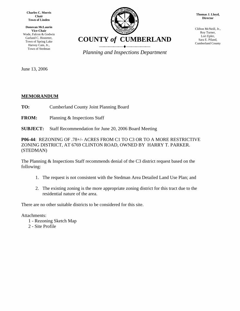
SUBJECT: Staff Recommendation for June 20, 2006 Board Meeting
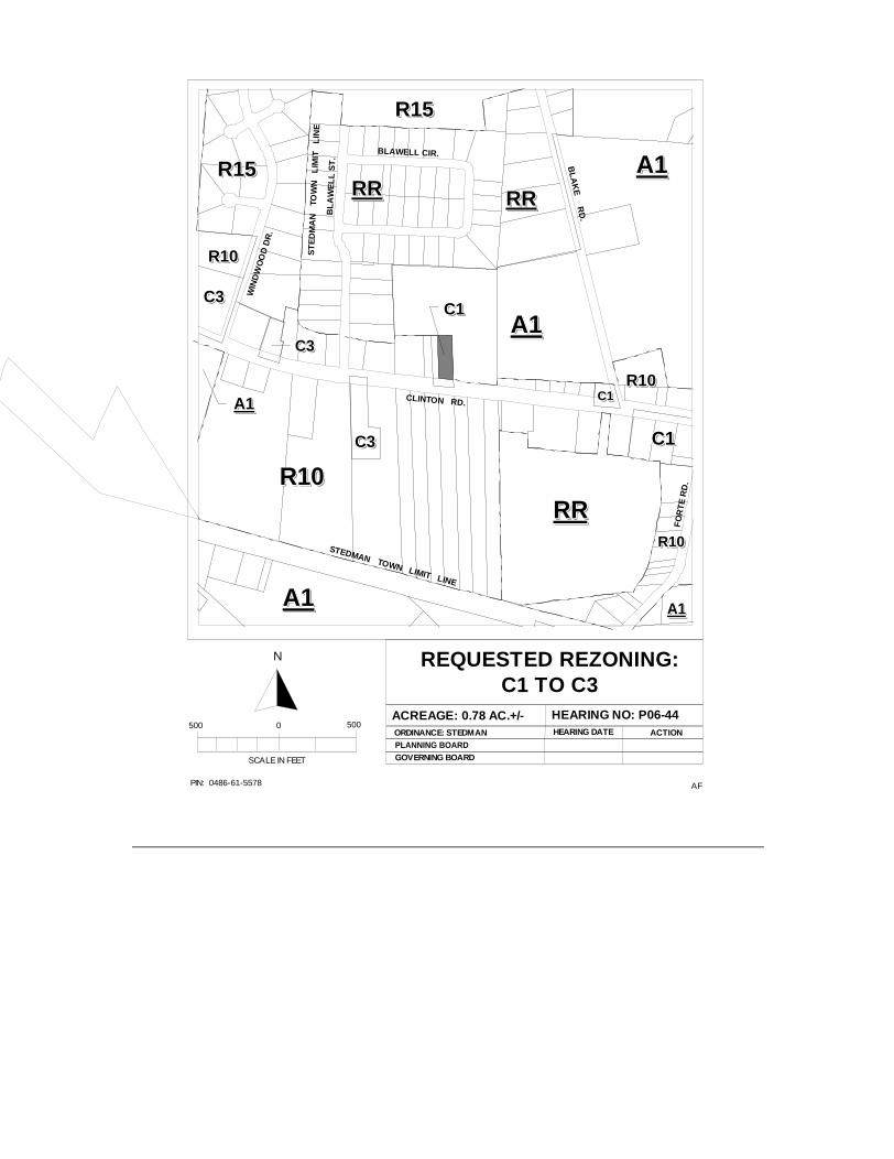
P06-44: REZONING OF .78+/- ACRES FROM C1 TO C3 OR TO A MORE RESTRICTIVE ZONING DISTRICT, AT 6769 CLINTON ROAD, OWNED BY HARRY T. PARKER. (STEDMAN)
The Planning & Inspections Staff recommends denial of the C3 district request based on the following:
1. The request is not consistent with the Stedman Area Detailed Land Use Plan; and
2. The existing zoning is the more appropriate zoning district for this tract due to the residential nature of the area.
There are no other suitable districts to be considered for this site.
Attachments: 1 - Rezoning Sketch Map 2 - Site Profile
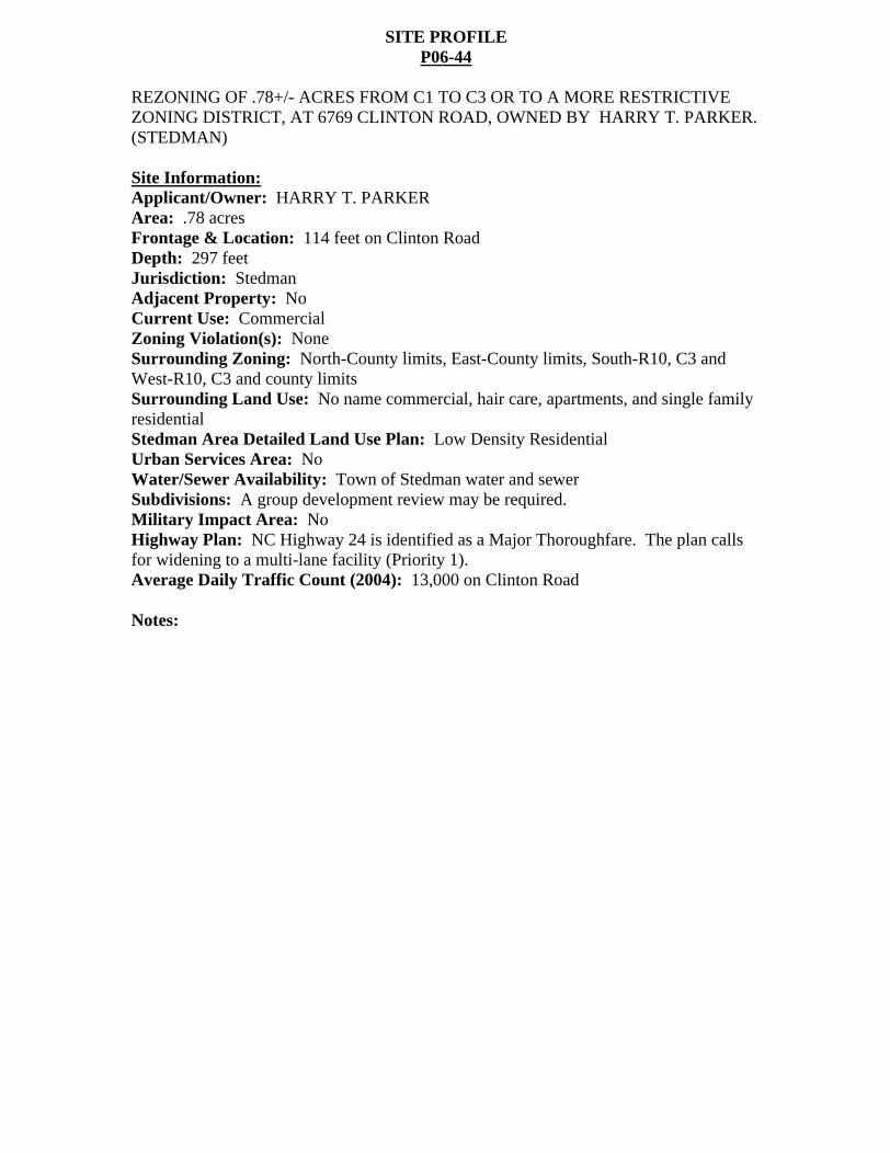
SITE PROFILE P06-44
REZONING OF .78+/- ACRES FROM C1 TO C3 OR TO A MORE RESTRICTIVE ZONING DISTRICT, AT 6769 CLINTON ROAD, OWNED BY HARRY T. PARKER. (STEDMAN)
Site Information:
Applicant/Owner: HARRY T. PARKER Area: .78 acres Frontage & Location: 114 feet on Clinton Road Depth: 297 feet Jurisdiction: Stedman Adjacent Property: No Current Use: Commercial Zoning Violation(s): None Surrounding Zoning: North-County limits, East-County limits, South-R10, C3 and West-R10, C3 and county limits Surrounding Land Use: No name commercial, hair care, apartments, and single family residential Stedman Area Detailed Land Use Plan: Low Density Residential Urban Services Area: No Water/Sewer Availability: Town of Stedman water and sewer Subdivisions: A group development review may be required. Military Impact Area: No Highway Plan: NC Highway 24 is identified as a Major Thoroughfare. The plan calls for widening to a multi-lane facility (Priority 1). Average Daily Traffic Count (2004): 13,000 on Clinton Road
Notes:
AFPIN: 0486-61-5578
REQUESTED REZONING:C1 TO C3
ACREAGE: 0.78 AC.+/- HEARING NO: P06-44ORDINANCE: STEDMANPLANNING BOARD
HEARING DATE ACTION
SCALE IN FEET
500 0 500
N
GOVERNING BOARD
A1A1A1A1A1A1A1A1A1A1
RRRRRRRRRRRRRRRRRRRR
RRRRRRRRRRRRRRRRRRRR
A1A1A1A1A1A1A1A1A1A1
A1A1A1A1A1A1A1A1A1A1
R15R15R15R15R15R15R15R15R15R15
R10R10R10R10R10R10R10R10R10R10C3C3C3C3C3C3C3C3C3C3
C3C3C3C3C3C3C3C3C3C3
C3C3C3C3C3C3C3C3C3C3
R10R10R10R10R10R10R10R10R10R10
C1C1C1C1C1C1C1C1C1C1
C1C1C1C1C1C1C1C1C1C1
A1A1A1A1A1A1A1A1A1A1
R10R10R10R10R10R10R10R10R10R10
R10R10R10R10R10R10R10R10R10R10CLINTON RD.
BLAWELL CIR.
BL
AW
EL
L S
T.
WIN
DW
OO
D D
R.
BL
AK
E R
D.
R15R15R15R15R15R15R15R15R15R15
A1A1A1A1A1A1A1A1A1A1
ST
ED
MA
N
TOW
N
LIM
IT
LIN
E
RRRRRRRRRRRRRRRRRRRR
FO
RT
E R
D.
STEDMAN TOWN LIMIT LINE
C1C1C1C1C1C1C1C1C1C1
Charles C. Morris
Chair Town of Linden
Donovan McLaurin Vice-Chair
Wade, Falcon & Godwin Garland C. Hostetter, Town of Spring Lake
Harvey Cain, Jr., Town of Stedman
COUNTY of CUMBERLAND
Planning and Inspections Department
Thomas J. Lloyd, Director
Clifton McNeill, Jr., Roy Turner, Lori Epler,
Sara E. Piland, Cumberland County
June 13, 2006
MEMORANDUM
TO: Cumberland County Joint Planning Board
FROM: Planning & Inspections Staff
SUBJECT: Staff Recommendation for June 20, 2006 Board Meeting
P06-45: REZONING OF .26 ACRES FROM R10 TO M(P) OR TO A MORE RESTRICTIVE ZONING DISTRICT, AT 3034 LEGION ROAD, SUBMITTED BY JIM MOHLER, OWNED BY DOUGLAS L. NEW.
The Planning & Inspections Staff recommends denial of M(P) and approval of the C(P) district based on the following:
1. The request is not consistent with the 2010 Land Use Plan, however the area meets the purpose and intent of the C(P) district; and
2. The C(P) district is in character with the existing zoning in the area.
The O&I(P) and C1(P) zoning districts are the only other suitable districts.
Attachments: 1 - Rezoning Sketch Map 2 - Site Profile
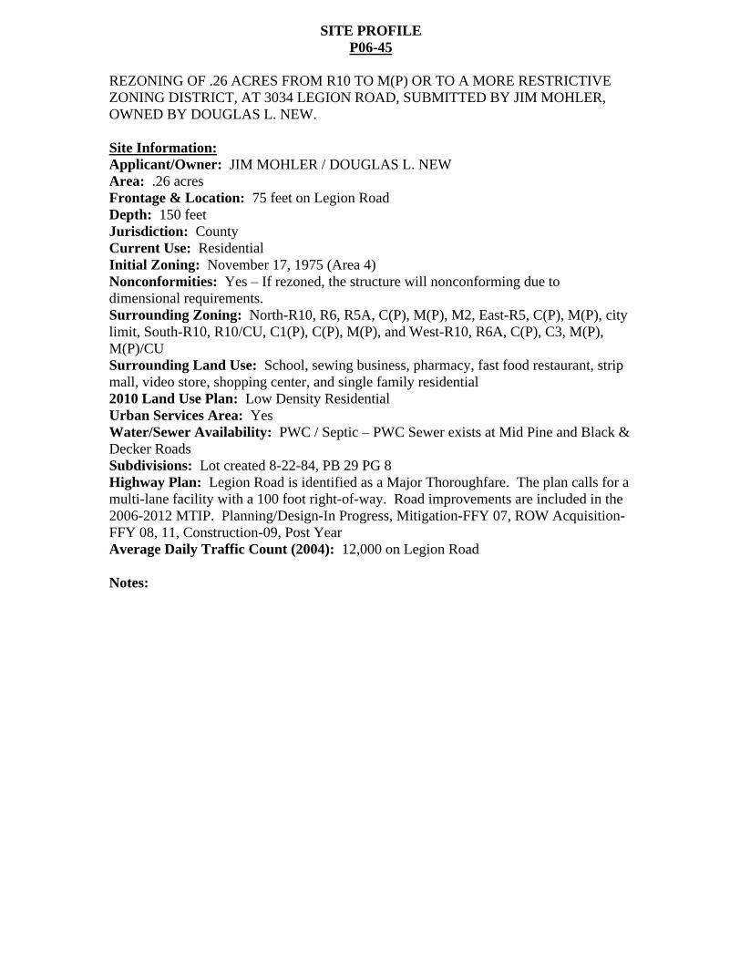
SITE PROFILE P06-45
REZONING OF .26 ACRES FROM R10 TO M(P) OR TO A MORE RESTRICTIVE ZONING DISTRICT, AT 3034 LEGION ROAD, SUBMITTED BY JIM MOHLER, OWNED BY DOUGLAS L. NEW.
Site Information:
Applicant/Owner: JIM MOHLER / DOUGLAS L. NEW Area: .26 acres Frontage & Location: 75 feet on Legion Road Depth: 150 feet Jurisdiction: County Current Use: Residential Initial Zoning: November 17, 1975 (Area 4) Nonconformities: Yes If rezoned, the structure will nonconforming due to dimensional requirements. Surrounding Zoning: North-R10, R6, R5A, C(P), M(P), M2, East-R5, C(P), M(P), city limit, South-R10, R10/CU, C1(P), C(P), M(P), and West-R10, R6A, C(P), C3, M(P), M(P)/CU Surrounding Land Use: School, sewing business, pharmacy, fast food restaurant, strip mall, video store, shopping center, and single family residential 2010 Land Use Plan: Low Density Residential Urban Services Area: Yes Water/Sewer Availability: PWC / Septic PWC Sewer exists at Mid Pine and Black & Decker Roads Subdivisions: Lot created 8-22-84, PB 29 PG 8 Highway Plan: Legion Road is identified as a Major Thoroughfare. The plan calls for a multi-lane facility with a 100 foot right-of-way. Road improvements are included in the 2006-2012 MTIP. Planning/Design-In Progress, Mitigation-FFY 07, ROW Acquisition-FFY 08, 11, Construction-09, Post Year Average Daily Traffic Count (2004): 12,000 on Legion Road
Notes:
AFPIN: 0425-56-3820
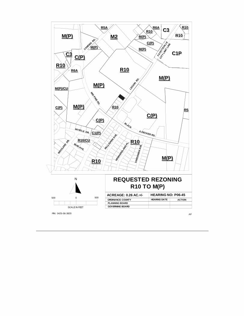
REQUESTED REZONINGR10 TO M(P)
ACREAGE: 0.26 AC.+/- HEARING NO: P06-45ORDINANCE: COUNTYPLANNING BOARD
HEARING DATE ACTION
SCALE IN FEET
500 0 500
N
GOVERNING BOARD
BLACK
& DECKER RD.
MID
PIN
E RD
.
CAMDEN RD.
LEG
ION R
D.
MYRTLE DR.
PELL
IGRIN
I AVE
.H
ENN
AR
DLA
ND
PL.
VA
RD
AM
AN
AV
E.
WO
OLA
RD DR.
BUIE AVE.
R10R10R10R10R10R10R10R10R10R10
M(P)M(P)M(P)M(P)M(P)M(P)M(P)M(P)M(P)M(P)
M(P)M(P)M(P)M(P)M(P)M(P)M(P)M(P)M(P)M(P)
M(P)M(P)M(P)M(P)M(P)M(P)M(P)M(P)M(P)M(P)
R5R5R5R5R5R5R5R5R5R5
C(P)C(P)C(P)C(P)C(P)C(P)C(P)C(P)C(P)C(P)
R10R10R10R10R10R10R10R10R10R10
R10R10R10R10R10R10R10R10R10R10
C(P)C(P)C(P)C(P)C(P)C(P)C(P)C(P)C(P)C(P)
C(P)C(P)C(P)C(P)C(P)C(P)C(P)C(P)C(P)C(P)
M2M2M2M2M2M2M2M2M2M2
M(P)M(P)M(P)M(P)M(P)M(P)M(P)M(P)M(P)M(P)
C(P)C(P)C(P)C(P)C(P)C(P)C(P)C(P)C(P)C(P)
C1(P)C1(P)C1(P)C1(P)C1(P)C1(P)C1(P)C1(P)C1(P)C1(P)
R10R10R10R10R10R10R10R10R10R10
C3C3C3C3C3C3C3C3C3C3
R10R10R10R10R10R10R10R10R10R10
R5AR5AR5AR5AR5AR5AR5AR5AR5AR5AR10R10R10R10R10R10R10R10R10R10
C(P)C(P)C(P)C(P)C(P)C(P)C(P)C(P)C(P)C(P)
R10R10R10R10R10R10R10R10R10R10
C1PC1PC1PC1PC1PC1PC1PC1PC1PC1P
C3C3C3C3C3C3C3C3C3C3R10R10R10R10R10R10R10R10R10R10M(P)M(P)M(P)M(P)M(P)M(P)M(P)M(P)M(P)M(P)
M(P)M(P)M(P)M(P)M(P)M(P)M(P)M(P)M(P)M(P)FA
YETT
EVIL
LE
CIT
Y LI
MIT
LIN
E
R10/CUR10/CUR10/CUR10/CUR10/CUR10/CUR10/CUR10/CUR10/CUR10/CU
R6AR6AR6AR6AR6AR6AR6AR6AR6AR6A
M(P)/CUM(P)/CUM(P)/CUM(P)/CUM(P)/CUM(P)/CUM(P)/CUM(P)/CUM(P)/CUM(P)/CU
M(P)M(P)M(P)M(P)M(P)M(P)M(P)M(P)M(P)M(P)M(P)M(P)M(P)M(P)M(P)M(P)M(P)M(P)M(P)M(P)
R6AR6AR6AR6AR6AR6AR6AR6AR6AR6A
Charles C. Morris
Chair Town of Linden
Donovan McLaurin Vice-Chair
Wade, Falcon & Godwin Garland C. Hostetter, Town of Spring Lake
Harvey Cain, Jr., Town of Stedman
COUNTY of CUMBERLAND
Planning and Inspections Department
Thomas J. Lloyd, Director
Clifton McNeill, Jr., Roy Turner, Lori Epler,
Sara E. Piland, Cumberland County
June 13, 2006
MEMORANDUM
TO: Cumberland County Joint Planning Board
FROM: Planning & Inspections Staff
SUBJECT: Staff Recommendation for June 20, 2006 Board Meeting
P06-49: REZONING OF TWO PARCELS TOTALING 33.71 ACRES FROM A1 TO M(P) OR TO A MORE RESTRICTIVE ZONING DISTRICT, NORTH AND SOUTH OF WADE-STEDMAN ROAD, ON THE WEST SIDE OF I-95, SUBMITTED BY JAMES A. MCLEAN III, OWNED BY LUTHER C. AND LINDA S. BARNES JR.
The Planning & Inspections Staff recommends denial of the M(P) district and withdrawal of the rezoning request based on the following:
1. The Wade Study Area Detailed Land Use Plan calls for Planned Commercial at this location; and
2. The M(P) zoning district is not appropriate at this location, which is a gateway into the Town of Wade from Interstate 95; and
3. According to the information provided, the applicant can accomplish the project by submitting a Special Use Permit application to the County Board of Adjustment.
The C(P) zoning district is the only other suitable district.
Attachments: 1 - Rezoning Sketch Map 2 - Site Profile
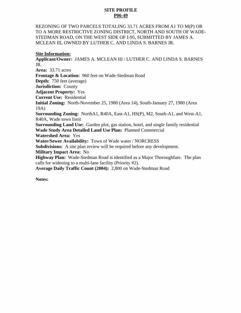
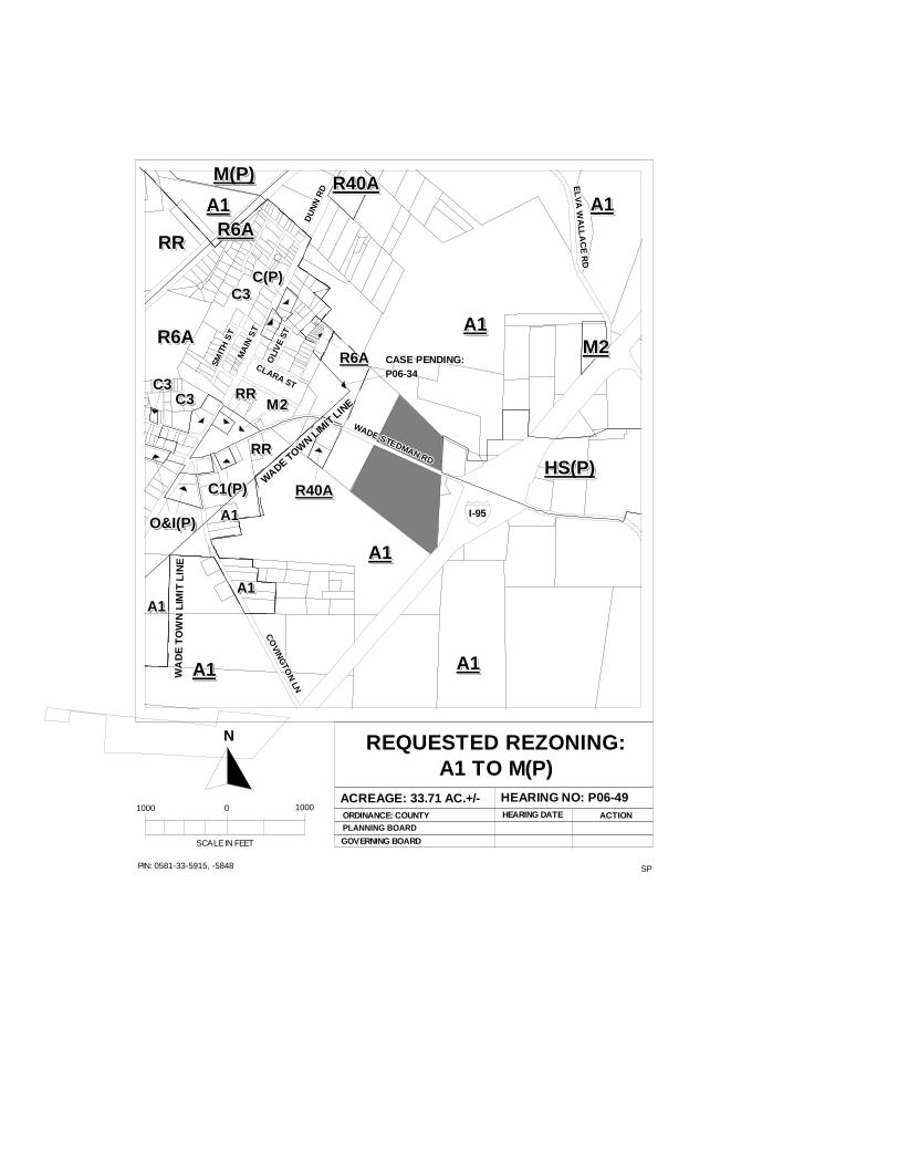
SITE PROFILE P06-49
REZONING OF TWO PARCELS TOTALING 33.71 ACRES FROM A1 TO M(P) OR TO A MORE RESTRICTIVE ZONING DISTRICT, NORTH AND SOUTH OF WADE-STEDMAN ROAD, ON THE WEST SIDE OF I-95, SUBMITTED BY JAMES A. MCLEAN III, OWNED BY LUTHER C. AND LINDA S. BARNES JR.
Site Information:
Applicant/Owner: JAMES A. MCLEAN III / LUTHER C. AND LINDA S. BARNES JR. Area: 33.71 acres Frontage & Location: 960 feet on Wade-Stedman Road Depth: 750 feet (average) Jurisdiction: County Adjacent Property: Yes Current Use: Residential Initial Zoning: North-November 25, 1980 (Area 14), South-January 27, 1980 (Area 19A) Surrounding Zoning: NorthA1, R40A, East-A1, HS(P), M2, South-A1, and West-A1, R40A, Wade town limit Surrounding Land Use: Garden plot, gas station, hotel, and single family residential Wade Study Area Detailed Land Use Plan: Planned Commercial Watershed Area: Yes Water/Sewer Availability: Town of Wade water / NORCRESS Subdivisions: A site plan review will be required before any development. Military Impact Area: No Highway Plan: Wade-Stedman Road is identified as a Major Thoroughfare. The plan calls for widening to a multi-lane facility (Priority #2). Average Daily Traffic Count (2004): 2,800 on Wade-Stedman Road
Notes:
SPPIN: 0581-33-5915, -5848
REQUESTED REZONING:A1 TO M(P)
ACREAGE: 33.71 AC.+/- HEARING NO: P06-49ORDINANCE: COUNTYPLANNING BOARD
GOVERNING BOARD
HEARING DATE ACTION
SCALE IN FEET
1000 0 1000
N
R40AR40AR40AR40AR40AR40AR40AR40AR40AR40A
M2M2M2M2M2M2M2M2M2M2
HS(P)HS(P)HS(P)HS(P)HS(P)HS(P)HS(P)HS(P)HS(P)HS(P)R40AR40AR40AR40AR40AR40AR40AR40AR40AR40A
A1A1A1A1A1A1A1A1A1A1A1A1A1A1A1A1A1A1A1A1
A1A1A1A1A1A1A1A1A1A1
A1A1A1A1A1A1A1A1A1A1
A1A1A1A1A1A1A1A1A1A1
M(P)M(P)M(P)M(P)M(P)M(P)M(P)M(P)M(P)M(P)
A1A1A1A1A1A1A1A1A1A1R6AR6AR6AR6AR6AR6AR6AR6AR6AR6A
R6AR6AR6AR6AR6AR6AR6AR6AR6AR6A
C3C3C3C3C3C3C3C3C3C3
M2M2M2M2M2M2M2M2M2M2C3C3C3C3C3C3C3C3C3C3 RRRRRRRRRRRRRRRRRRRR
C1(P)C1(P)C1(P)C1(P)C1(P)C1(P)C1(P)C1(P)C1(P)C1(P)
O&I(P)O&I(P)O&I(P)O&I(P)O&I(P)O&I(P)O&I(P)O&I(P)O&I(P)O&I(P)O&I(P)O&I(P)O&I(P)O&I(P)O&I(P)O&I(P)O&I(P)O&I(P)O&I(P)O&I(P)
C3C3C3C3C3C3C3C3C3C3
R6AR6AR6AR6AR6AR6AR6AR6AR6AR6A
A1A1A1A1A1A1A1A1A1A1
A1A1A1A1A1A1A1A1A1A1
A1A1A1A1A1A1A1A1A1A1
RRRRRRRRRRRRRRRRRRRR
DU
NN
RD
DU
NN
RD
DU
NN
RD
DU
NN
RD
DU
NN
RD
DU
NN
RD
DU
NN
RD
DU
NN
RD
DU
NN
RD
MA
IN S
T
MA
IN S
T
MA
IN S
T
MA
IN S
T
MA
IN S
T
MA
IN S
T
MA
IN S
T
MA
IN S
T
MA
IN S
T
SMIT
H S
T
SMIT
H S
T
SMIT
H S
T
SMIT
H S
T
SMIT
H S
T
SMIT
H S
T
SMIT
H S
T
SMIT
H S
T
SMIT
H S
T
WADE-STEDMAN RD
WADE-STEDMAN RD
WADE-STEDMAN RD
WADE-STEDMAN RD
WADE-STEDMAN RD
WADE-STEDMAN RD
WADE-STEDMAN RD
WADE-STEDMAN RD
WADE-STEDMAN RD
CLARA ST
CLARA ST
CLARA ST
CLARA ST
CLARA ST
CLARA ST
CLARA ST
CLARA ST
CLARA ST
OLI
VE
ST
OLI
VE
ST
OLI
VE
ST
OLI
VE
ST
OLI
VE
ST
OLI
VE
ST
OLI
VE
ST
OLI
VE
ST
OLI
VE
ST
CO
VING
TON
LN
CO
VING
TON
LN
CO
VING
TON
LN
CO
VING
TON
LN
CO
VING
TON
LN
CO
VING
TON
LN
CO
VING
TON
LN
CO
VING
TON
LN
CO
VING
TON
LN
I-95I-95I-95I-95I-95I-95I-95I-95I-95
EL
VA
WA
LLA
CE
RD
EL
VA
WA
LLA
CE
RD
EL
VA
WA
LLA
CE
RD
EL
VA
WA
LLA
CE
RD
EL
VA
WA
LLA
CE
RD
EL
VA
WA
LLA
CE
RD
EL
VA
WA
LLA
CE
RD
EL
VA
WA
LLA
CE
RD
EL
VA
WA
LLA
CE
RD
WA
DE
TO
WN
LI M
IT L
INE
WA
DE
TO
WN
LI M
IT L
INE
WA
DE
TO
WN
LI M
IT L
INE
WA
DE
TO
WN
LIM
IT L
INE
WA
DE
TO
WN
LIM
IT L
INE
WA
DE
TO
WN
LIM
IT L
I NE
WA
DE
TO
WN
LIM
IT L
I NE
WA
DE
TO
WN
LIM
IT L
I NE
WA
DE
TO
WN
LIM
IT L
INE
WADE TOW
N LIM
IT LIN
E
WADE TOW
N LIM
IT LIN
E
WADE TOW
N LIM
IT LIN
E
WADE TOW
N LIM
IT LIN
E
WADE TOW
N LIM
IT LIN
E
WADE TOW
N LIM
IT LIN
E
WADE TOW
N LIM
IT LIN
E
WADE TOW
N LIM
IT LIN
E
WADE TOW
N LIM
IT LIN
E
RRRRRRRRRRRRRRRRRRRR
CASE PENDING:CASE PENDING:CASE PENDING:CASE PENDING:CASE PENDING:CASE PENDING:CASE PENDING:CASE PENDING:CASE PENDING:P06-34P06-34P06-34P06-34P06-34P06-34P06-34P06-34P06-34
C(P)C(P)C(P)C(P)C(P)C(P)C(P)C(P)C(P)C(P)