velmu first phase finalized all data in a new map portal 1-2016-335/documents/presentation 4... ·...
TRANSCRIPT

VELMU first phase finalized – All data in a new map portal
Markku Viitasalo & VELMU-consortium
Juuso Haapaniemi / Metsähallitus
VELMU
The Finnish Inventory Programme for the
Underwater Marine Environment

main objectives
• To do an inventory of underwater habitats and species
• To support marine conservation and sustainable use of marine resources
• To build up a database and a new Map Portal
Juuso Haapaniemi
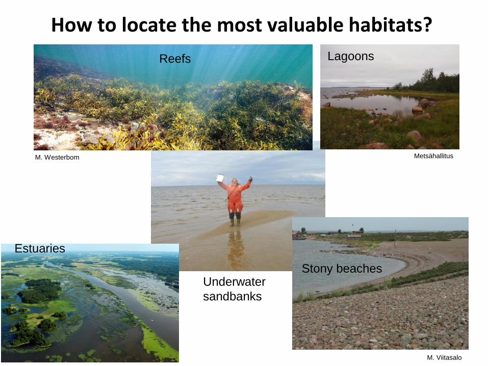
Lagoons
Stony beaches
Estuaries
Reefs
M. Westerbom Metsähallitus
M. Viitasalo
Underwater
sandbanks
How to locate the most valuable habitats?

Bladderwrack Fucus vesiculosus
How to locate habitat forming and rare species?
Eelgrass Zostera marina
Blue mussel Mytilus
trossulus
Pekka Tuuri Parks & Wildlife Finland
Parks & Wildlife Finland / H. Arponen
Hippuris tetraphylla
• Within the EU occurs only in Finland
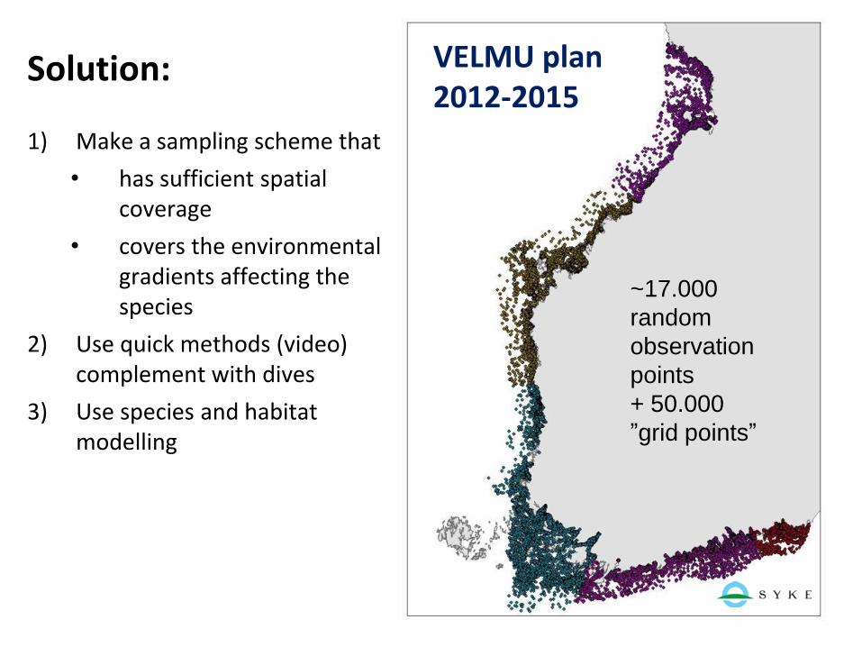
1) Make a sampling scheme that
• has sufficient spatial coverage
• covers the environmental gradients affecting the species
2) Use quick methods (video) complement with dives
3) Use species and habitat modelling
~17.000
random
observation
points
+ 50.000
”grid points”
VELMU plan 2012-2015
Solution:

How were the data collected? Geological and biological inventories
• Bottom topography, geology
• Habitats
• Algae and water plants
• Invertebrates
• Fish spawning areas
Drop video
ROV
Benthic sampling
Sampling of fish larvae
Geological
echosounding
methods
Scuba diving
Algal lines
Parks & Wildlife Finland
Geol. Surv. Fin.
/ H. Kutvonen
SYKE

VELMU ”drop video” method
SYKE / M. Viitasalo
SYKE / M. Viitasalo
Parks & Wildlife Finland
ROV
M. Viitasalo, SYKE

VELMU partners
• Ministry of the Environment (funding and steering) • Finnish Environment Institute (coordination) • Coastal Centres for Economic Development, Transport and the Environment • Parks & Wildlife Finland • Natural Resources Institute • Geological Survey of Finland • Naval Research Insitute (Finnish Navy) • Åbo Akademi University
Larger EU-funded projects:
Funding • Ministry of the Environment: ca 1,3 M€ /year in 2011-2015

Examples of end
products of VELMU

Geological maps
Geological Survey
Finland

Geographical
distribution maps: blue mussel Mytilus trossulus
Parks & Wildlife Finland / H. Arponen
SYKE / M. Viitasalo
Green: Mytilus found
Red: Mytilus not found

Species distribution models
Eelgrass Zostera marina - preliminary probability model / Elina Virtanen, SYKE

Example: Kymenlaakso Spatial Plan, SE Finland
Usage of VELMU data
in maritime spatial
planning

Yellow = underwater
eskers
Underwater sand-banks with 1 or 2 indicator species
Underwater sandbanks
Underwater eskers and sandbanks, and their indicator species

Summary graph Eskers, sandbanks, reefs, bladderwracks and indicator species
The current Natura 2000 area

Decision making Where to allow dumping of dredged materials?

The spatial plan

VELMU
Method
development

LIDAR Light Detection and Ranging Measures the distance to the ground by emitting red and green laser light Can identify shapes also underwater.
gulfsci.usgs.gov/tampabay

WorldView-2 satellite image depicting bottom depths from 0 to 4 meters, Hanko Peninsula, SW coast of Finland. H. Piepponen / SYKE; WorldView data by FRESHMON project (FP7 proj. nr. 263287). (SYKE / H. Piepponen)
WorldView-2 satellite image showing extent of reed (Phragmites australis; light green) in Tammisaari Archipelago, SW coast of Finland. (SYKE / M. Koskelainen)
Remote sensing

UAV (Unmanned Aerial Vehicle)
Mats Westerbom
Photo: Jan Ekebom

AUV (Autonomous Underwater Vehicle)
Parks & Wildlife Finland / Michael Haldin
SUPERB project & DeepVision Sweden

Some VELMU highlights 2004-2015

• 122 640 observation points:
• 95 600 video points (mainly drop-videos & ROV)
• 23 200 dive line points, in approx 2000 dive lines
• 1000+ benthos samples
• 1800 Gulf-lines for fish larvae
• 700 beach seine areas for fish larvae
• 340 white board points for fish larvae
• 20 000 km echosounding / 784 sediment samples
• 100 000+ underwater photos
February 2016
VELMU statistics

De Geer moraines at Rauma
– new finding 2012
Kuva: www.merenkurkku.fi Geological Survey Finland

Odd clay canyons in
the Bothnian Bay

A lot of rare and threatened species, and fish nursery areas in shallow bays
© Luke / Lari Veneranta
Najas tenuissima
Chara tomentosa
Alisma wahlenbergii
Huumanpohja, Kotka

Mud crab observed in the Archipelago Sea 1st time in 2009; expands rapidly
2015 found in River Aura, middle of Turku City
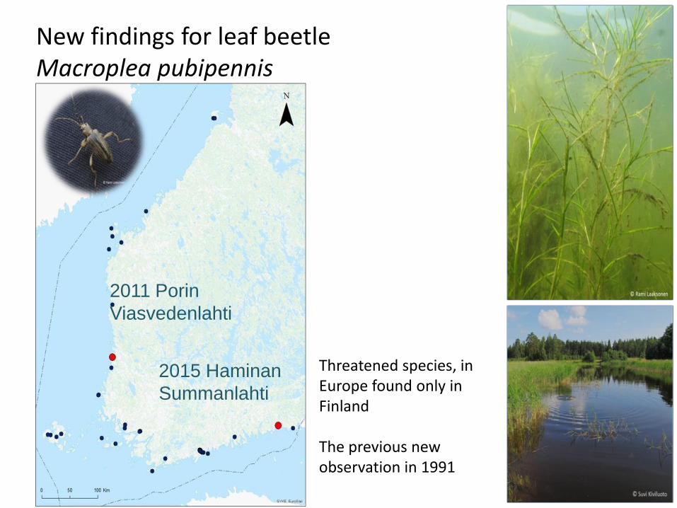
New findings for leaf beetle Macroplea pubipennis
2011 Porin
Viasvedenlahti
2015 Haminan
Summanlahti
Threatened species, in Europe found only in Finland The previous new observation in 1991

Two unknown species found!
• Murchisonellidae?
• Hamina E Gulf of Finland, 2013
• Length 2-4 mm, population density up to 500 ind. /m2
• Laonome sp.
• Turku, Inkoo, Uusikaupunki 2014, 2015

http://paikkatieto.ymparisto.fi/velmu
VELMU Map Portal

• An encyclopedia, atlas and photo book of the Finnish underwater
marine environment; to be published in 2017
Juuso Haapaniemi
”VELMU Atlas”

Summary
1. VELMU reached its main goals
2. A lot of new observations on habitats and species
3. Information can be used in conservation and sustainable use of the marine ecosystem, and in maritime spatial planning
4. VELMU will continue in a focused way
Mats Westerbom / Parks & Wildlife Finland

We did it!