~varta(~ ~~4- ~~,') federal emergency management agency
TRANSCRIPT

Page 1 of 12 I I Date: September 23, 2004 lease No.: 0~0~8502X l LOMR-F
~VARTA(~ ~~4-
~"~,""') Federal Emergency Management Agency ~~~~ ~ :-.. Washington, D.C. 20472 ~ <;;~
~"liVn s"-c; -LETTER OF MAP REVISION BASED ON FILL DETERMINATION DOCUMENT (REMOVAL)
COMMUNITY AND MAP PANEL INFORMATION LEGAL PROPERTY DESCRIPTION
CITY OF WEST PALM BEACH, PALM Lots 1 through 108 and Tract R, The Lakes of Laguna, as shown on the Plat
COMMUNITY BEACH COUNTY, FLORIDA thereof, recorded in Plat Book 75, Pages 162 through 165, filed on August 17,
1995, by the Clerk of the Circuit Court, Palm Beach County, Florida COMMUNITY NO.: 120229
NUMBER: 1201920145B
AFFECTED NAME: CITY OF WEST PALM BEACH, PALM MAP PANEL BEACH COUNTY, FLORIDA
DATE: 11¥15'1992
FLOODING SOURCE: C-17 CANAL SUB-BASIN, REACH 1 APPROXIMATE LATITUDE & LONGITUDE OF PROPERTY: 26.745,-80.102 SOURCE OF LAT & LONG: PRECISION MAPPING STREETS 6.0 DATUM: NAD 83
DETERMINATION
OUTCOME 1% ANNUAL LOWEST LOWEST WHAT IS CHANCE ADJACENT LOT
LOT BLOCK! STREET REMOVED FLOOD FLOOD GRADE ELEVATION SUBDIVISION SECTION FROM THE ZONE ELEVATION ELEVATION {NGVD29)
SFHA (NGVD 29) (NGVD 29)
1 The Lakes of El Camino Real & Property 16.0 feet 17.1 feet - Laguna Via del Lagos B 16.0 feet
Special Flood Hazard Area (SFHA)- The SFHA is an area that would be inundated by the flood having a 1-percent chance of being equaled or exceeded in any given year (base flood).
ADDITIONAL CONSIDERATIONS (Please refer to the appropriate section on Attachment 1 for the additional considerations listed below.)
DETERMINATION TABLE (CONTINUED) SUPERSEDES PREVIOUS DETERMINATION
ANNEXATION
STUDY UNDERWAY
This document provides the Federal Emergency Management Agency's determination regarding a request for a Letter of Map Revision based on Fill for the property described above. Using the information submitted and the effective National Flood Insurance Program (NFIP) map, we have determined that the property(ies) is/are not located in the SFHA, an area inundated by the flood having a 1-percent chance of being equaled or exceeded in any given year {base flood). This document revises the effective NFIP map to remove the subject property from the SFHA located on the effective NFIP map; therefore, the Federal mandatory flood insurance requirement does not apply. However, the lender has the option to continue the flood insurance requirement to protect its financial risk on the loan. A Preferred Risk Policy (PRP) is available for buildings located outside the SFHA. Information about the PRP and how one can apply is enclosed.
This determination is based on the flood data presently available. The enclosed documents provide additional information regarding this determination. If you have any questions about this document, please contact the FEMA Map Assistance Center toll free at (877) 336-2627 (877-FEMA MAP) or by letter addressed to the Federal Emergency Management Agency, P.O. Box 2210, Merrifield, VA 22116-2210. Additional information about the NFIP is available on our web site at http://www.fema.gov/nfip/.
~ ~L Doug Bellomo, P .. , CFM, Acting Chief Hazard Identification Section, Mitigation Division Version 1.3.4 Emergency Preparedness and Response Directorate 621751 03 030 1262616YOE 00003012626

Page 2 of 12 I !Date: September 23,2004 !Case No.: 0~0~8502X I LOMR-F
~yA.RTA[~
~~0 Federal Emergency Management Agency (~~- --~9n,
~ ....... !; Washington, D.C. 20472 ~~ <>~
<--1zvo s~c; -LETTER OF MAP REVISION BASED ON FILL DETERMINATION DOCUMENT (REMOVAL)
ATTACHMENT 1 (ADDITIONAL CONSIDERATIONS)
DETERMINATION TABLE (CONTINUED)
OUTCOME 1% ANNUAL LOWEST LOWEST
WHAT IS CHANCE ADJACENT LOT BLOCK/ REMOVED FLOOD FLOOD GRADE ELEVATION
LOT SUBDIVISION STREET FROM THE ZONE ELEVATION ELEVATION SECTION (NGVD 29) SFHA (NGVD29) (NGVD 29)
13 - The Lakes of El Camino Real Property B 16.0 feet 17.1 feet 16.0 feet Laguna
14 - The Lakes of El Camino Real Property B 16.0 feet 17.1 feet 16.1 feet Laguna
15 - The Lakes of El Camino Real Laguna
Property B 16.0 feet 17.1 feet 16.3 feet
16 - The Lakes of El Camino Real Laguna
Property B 16.0 feet 17.5 feet 16.4 feet
17 - The Lakes of El Camino Real Property B 16.0 feet 17.7 feet 16.7 feet Laguna
18 - The Lakes of El Camino Real Property B 16.0 feet 17.8 feet 16.8 feet Laguna
19 - The Lakes of El Camino Real Property B 16.0 feet 17.9 feet 16.9 feet Laguna
20 - The Lakes of El Camino Real Laguna
Property B 16.0 feet 17.9 feet 17.0 feet
21 - The Lakes of El Camino Real Property B 16.0 feet 17.9 feet 16.9 feet Laguna
22 - The Lakes of El Camino Real Property B 16.0 feet 17.8 feet 16.6 feet Laguna
23 - The Lakes of El Camino Real Property B 16.0 feet 17.6 feet 16.3 feet Laguna
24 - The Lakes of El Camino Real Property B 16.0 feet 17.1 feet 16.1 feet Laguna
25 - The Lakes of El Camino Real Property B 16.0 feet 17.1 feet 16.0 feet Laguna
This attachment provides additional information regarding this request. If you have any questions about this attachment, please contact the FEMA Map Assistance Center toll free at (877) 336-2627 (877-FEMA MAP) or by letter addressed to the Federal Emergency Management Agency, P.O. Box 2210, Merrifield, VA 22116-2210. Additional information about the NFIP is available on our web site at http://www.fema.gov/nfip/.
-.., ~~
iJ:g Bellomo, Plo., CFM, Acting Chief Hazard Identification Section, Mitigation Division Version 1.3.4 Emergency Preparedness and Response Directorate 621751030301262616YOE00003012626

Page 3 of 12 I jDate: September 23,2004 I Case No.: 0~0~8502X I LOMR-F
~\'P.RTA(~ ~~,.j.,
~'?-,.~~~ Federal Emergency Management Agency ~~~.tl Washington, D.C. 20472 ~~ '\)~ <-'~IVo s~c; -
LETTER OF MAP REVISION BASED ON FILL DETERMINATION DOCUMENT (REMOVAL)
ATTACHMENT 1 (ADDITIONAL CONSIDERATIONS)
DETERMINATION TABLE (CONTINUED)
OUTCOME 1% ANNUAL LOWEST LOWEST
WHAT IS CHANCE ADJACENT LOT
BLOCK! REMOVED FLOOD FLOOD GRADE ELEVATION LOT SUBDIVISION STREET FROM THE ZONE ELEVATION ELEVATION SECTION (NGVD29)
SFHA (NGVD 29) (NGVD 29)
30 - The Lakes of El Camino Real Property B 16.0 feet 17.1 feet 16.0 feet Laguna
31 - The Lakes of El Camino Real Property B 16.0 feet 17.2 feet 16.2 feet Laguna
32 - The Lakes of El Camino Real Property B 16.0 feet 17.3 feet 16.3 feet Laguna
33 - The Lakes of El Camino Real Property B 16.0 feet 17.5 feet 16.5 feet Laguna
34 - The Lakes of El Camino Real Property 8 16.0 feet 17.5 feet 16.6 feet Laguna
35 - The Lakes of El Camino Real Property B 16.0 feet 17.6 feet 16.7 feet Laguna
36 - The Lakes of El Camino Real Property B 16.0 feet 17.6 feet 16.7 feet Laguna
37 - The Lakes of El Camino Real Laguna
Property B 16.0 feet 17.5 feet 16.6 feet
38 - The Lakes of El Camino Real Laguna
Property B 16.0 feet 17.4 feet 16.5 feet
39 - The Lakes of El Camino Real Property B 16.0 feet 17.3 feet 16.3 feet Laguna
40 - The Lakes of El Camino Real Property B 16.0 feet 17.1 feet 16.1 feet Laguna
41 - The Lakes of El Camino Real Laguna
Property B 16.0 feet 17.1 feet 16.0 feet
50 - The Lakes of El Camino Real Laguna
Property B 16.0 feet 17.1 feet 16.0 feet
This attachment provides additional information regarding this request. If you have any questions about this attachment, please contact the FEMA Map Assistance Center toll free at (877) 336-2627 (877-FEMA MAP) or by letter addressed to the Federal Emergency Management Agency, P.O. Box 2210, Merrifield, VA 22116-2210. Additional information about the NFIP is available on our web site at http://www.fema.gov/nfip/.
:--:, --.--b_ .l.L
Doug Bellomo, FE~. CFM, Acting Chief Hazard Identification Section, Mitigation Division Version 1.3.4 Emergency Preparedness and Response Directorate 62175103 0301262616YOE00003012626
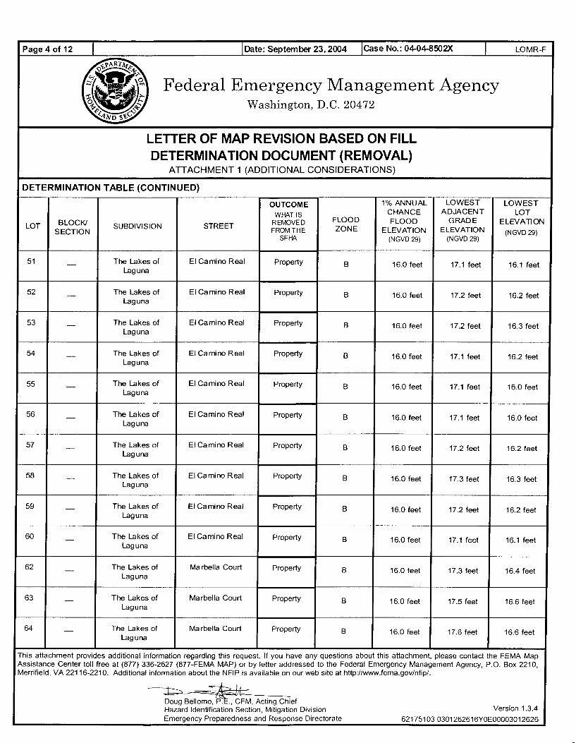
Page 4 of 12 I I Date: September 23, 2004 lease No.: 04-04-8502X I LOMR-F
x.VA.RT.Af~
~w~~ r'?· -~?n) Federal Emergency Management Agency ~~~ 0 f... Washington, D.C. 20472 ~~ ~~
<-'~No s~c; -LETTER OF MAP REVISION BASED ON FILL DETERMINATION DOCUMENT (REMOVAL)
ATTACHMENT 1 (ADDITIONAL CONSIDERATIONS)
DETERMINATION TABLE (CONTINUED)
OUTCOME 1% ANNUAL LOWEST LOWEST
WHAT IS CHANCE ADJACENT LOT BLOCK! REMOVED FLOOD FLOOD GRADE ELEVATION
LOT SUBDIVISION STREET FROM THE ZONE ELEVATION ELEVATION SECTION (NGVD29) SFHA (NGVD 29) (NGVD 29)
51 - The Lakes of El Camino Real Property B 16.0 feet 17.1 feet 16.1 feet Laguna
52 - The Lakes of El Camino Real Property B 16.0 feet 17.2 feet 16.2 feet Laguna
53 - The Lakes of El Camino Real Laguna
Property B 16.0 feet 17.2 feet 16.3 feet
54 - The Lakes of El Camino Real Laguna
Property B 16.0 feet 17.1 feet 16.2 feet
55 - The Lakes of El Camino Real Property B 16.0 feet 17.1 feet 16.0 feet Laguna
56 - The Lakes of El Camino Real Property B 16.0 feet 17.1 feet 16.0 feet Laguna
57 - The Lakes of El Camino Real Property B 16.0 feet 17.2 feet 16.2 feet Laguna
58 - The Lakes of El Camino Real Laguna
Property B 16.0 feet 17.3 feet 16.3 feet
59 - The Lakes of El Camino Real Laguna
Property B 16.0 feet 17.2 feet 16.2 feet
60 - The Lakes of El Camino Real Property B 16.0 feet 17.1 feet 16.1 feet Laguna
62 - The Lakes of Marbella Court Property B 16.0 feet 17.3 feet 16.4 feet Laguna
63 - The Lakes of Marbella Court Laguna
Property B 16.0 feet 17.5 feet 16.6 feet
64 - The Lakes of Ma rbella Court Laguna
Property B 16.0 feet 17.6 feet 16.6 feet
This attachment provides additional information regarding this request. If you have any questions about this attachment, please contact the FEMA Map Assistance Center toll free at (877) 336-2627 (877-FEMA MAP) or by letter addressed to the Federal Emergency Management Agency, P.O. Box 2210, Merrifield, VA 22116-2210. Additional information about the NFIP is available on our web site at http://www.fema.gov/nfip/.
-:--::, -+--, I
Doug Bellomo, ?f. CFM, Acting Chief Hazard Identification Section, Mitigation Division Version 1.3.4 Emergency Preparedness and Response Directorate 621751030301262616YOE00003012626

Page 5 of 12 I !Date: September 23,2004 lease No.: 0~0~8502X I LOMR-F
~yARTA(~
r~~ 1: [~;:) Federal Emergency Management Agency 0 !-.. Washington, D.C. 20472 ~~ "p
<-'~IVo .,~c -LETTER OF MAP REVISION BASED ON FILL DETERMINATION DOCUMENT (REMOVAL)
ATTACHMENT 1 (ADDITIONAL CONSIDERATIONS)
DETERMINATION TABLE (CONTINUED)
OUTCOME 1% ANNUAL LOWEST LOWEST
WHAT IS CHANCE ADJACENT LOT BLOCK! REMOVED FLOOD FLOOD GRADE ELEVATlON
LOT SUBDIVISION STREET FROM THE ZONE ELEVATION ELEVATION SECTION (NGVD29)
SFHA (NGVD29) (NGVD29)
65 - The Lakes of Ma rbella Court Property B 16.0 feet 17.6 feet 16.6 feet laguna
66 - The Lakes of Ma rbella Court Property B 16.0 feet 17.5 feet 16.5 feet Laguna
67 - The Lakes of Ma rbella Court Laguna
Property B 16.0 feet 17.3 feet 16.4 feet
73 - The Lakes of El Camino Real & Property B 16.0 feet 17.1 feet 16.0 feet Laguna Via del Lagos
84 - The Lakes of El Camino Real & Property B 16.0 feet 17.4 feet 16.1 feet Laguna Via del Lagos
87 - The Lakes of El Camino Real Property B 16.0 feet 17.1 feet 16.0 feet Laguna
88 - The Lakes of El Camino Real Property B 16.0 feet 17.2 feet 16.2 feet Laguna
89 - The Lakes of El Camino Real Laguna
Property B 16.0 feet 17.4 feet 16.4 feet
90 - The Lakes of El Camino Real Property B 16.0 feet 17.6 feet 16.5 feet Laguna
91 - The Lakes of El Camino Real & Property B 16.0 feet 17.3 feet 16.1 feet Laguna Via del Lagos
92 - The Lakes of Via Del Lagos Property B 16.0 feet 17.3 feet 16.4 feet Laguna
93 - The Lakes of Via Del Lagos Property B 16.0 feet 17.2 feet 16.2 feet Laguna
94 - The Lakes of Via Del Lagos Property B 16.0 feet 17.1 feet 16.1 feet Laguna
This attachment provides additional information regarding this request. If you have any questions about this attachment, please contact the FEMA Map Assistance Center toll free at (877) 336-2627 (877-FEMA MAP) or by letter addressed to the Federal Emergency Management Agency, P.O. Box 2210, Merrifield, VA 22116-2210. Additional information about the NFIP is available on our web site at http://www.fema.gov/nfip/.
---., ~I
Doug Bellomo, ?f. CFM, Acting Chief Hazard Identification Section, Mitigation Division Version 1.3.4 Emergency Preparedness and Response Directorate 62175103 0301262616YOE00003012626

Page 6 of 12 J !Date: September 23,2004 !Case No.: 04-04-8502>< I
Federal Emergency Management Agency Washington, D.C. 20472
LETTER OF MAP REVISION BASED ON FILL DETERMINATION DOCUMENT (REMOVAL)
ATTACHMENT 1 (ADDITIONAL CONSIDERATIONS)
ANNEXATION (This Additional Consideration applies to the preceding 53 Properties.)
LOMR-F
Although the subject of this determination is shown on the National Flood Insurance Program map as being located in a community other than the community indicated on the Determination/Comment Document, it has been annexed by the community referenced therein.
STUDY UNDERWAY (This additional consideration applies to all properties in the LOMR-F DETERMINATION DOCUMENT (REMOVAL)) This determination is based on the flood data presently available. However, the Federal Emergency Management Agency is currently revising the National Flood Insurance Program (NFIP) map for the community. New flood data could be generated that may affect this property. When the new NFIP map is issued it will supersede this determination. The Federal requirement for the purchase of flood insurance will then be based on the newly revised NFIP map.
SUPERSEDES OUR PREVIOUS DETERMINATION (This Additional Consideration applies to all properties in the LOMR-F DETERMINATION DOCUMENT (REMOVAL).) The attached Determination Document corrects and supersedes the determination made for this property in the Letter of Map Revision based on Fill (LOMR-F}, dated 07/06/2004. The changes include updating the Community Name, adding 'Annexation' to Additional Considerations, and revising the Outcome for Lots 13 and 41 in the Determination Document.
This attachment provides additional information regarding this request. If you have any questions about this attachment, please contact the FEMA Map Assistance Center toll free at (877) 336-2627 (877-FEMA MAP) or by letter addressed to the Federal Emergency Management Agency, P.O. Box 2210, Merrifield, VA 22116-2210. Additional information about the NFIP is available on our web site at http://www.fema.gov/nfip/.
--J.-....., I
Doug Bellomo, PJ: .. CFM, Acting Chief Hazard Identification Section, Mitigation Division Emergency Preparedness and Response Directorate
Version 1.3.4
62175103 0301262616YOE00003012626
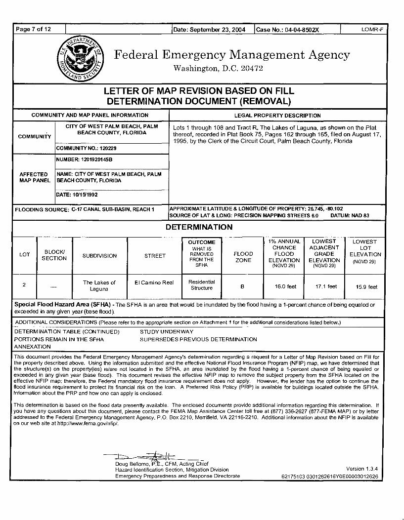
Page 7 of 12 I I Date: September 23, 2004 I Case No.: 04-04-8502X I LOMR-F
:t.\'ART;~ff' ~~4
r"&~, Federal Emergency Management Agency -:r. r_ .... 0 ~... ~
Washington, D.C. 20472 ~~ <:>~ <"~No s~c;
LETTER OF MAP REVISION BASED ON FILL DETERMINATION DOCUMENT (REMOVAL)
COMMUNITY AND MAP PANEL INFORMATION LEGAL PROPERTY DESCRIPTION
CITY OF WEST PALM BEACH, PALM Lots 1 through 108 and Tract R, The Lakes of Laguna, as shown on the Plat
COMMUNITY BEACH COUNTY, FLORIDA thereof, recorded in Plat Book 75, Pages 162 through 165, filed on August 17,
1995, by the Clerk of the Circuit Court, Palm Beach County, Florida COMMUNITY NO.: 120229
NUMBER: 1201920145B
AFFECTED NAME: CITY OF WEST PALM BEACH, PALM MAP PANEL BEACH COUNTY, FLORIDA
DATE: 1G'1511992
FLOODING SOURCE: C-17 CANAL SUB-BASIN, REACH 1 APPROXIMATE LATITUDE & LONGITUDE OF PROPERTY: 26.745,-80.102 SOURCE OF LAT & LONG: PRECISION MAPPING STREETS 6.0 DATUM: NAD 83
DETERMINATION
OUTCOME 1% ANNUAL LOWEST LOWEST WHAT IS CHANCE ADJACENT LOT
LOT BLOCK! SUBDIVISION STREET REMOVED FLOOD FLOOD GRADE ELEVATION
SECTION FROM THE ZONE ELEVATION ELEVATION (NGVD29) SFHA (NGVD29) (NGVD29)
--
2 The Lakes of El Camino Real Residential - Laguna Structure B 16.0 feet 17.1 feet 15.9 feet
Special Flood Hazard Area (SFHA)- The SFHA is an area that would be inundated by the flood having a 1-percent chance of being equaled or exceeded in any given year (base flood}
ADDITIONAL CONSIDERATIONS (Please refer to the appropriate section on Attachment 1 for the additional considerations listed below.)
DETERMINATION TABLE (CONTINUED) STUDY UNDERWAY
PORTIONS REMAIN IN THE SFHA SUPERSEDES PREVIOUS DETERMINATION ANNEXATION
This document provides the Federal Emergency Management Agency's determination regarding a request for a Letter of Map Revision based on Fill for the property described above. Using the information submitted and the effective National Flood Insurance Program (NFIP) map, we have determined that the structure(s) on the property(ies) is/are not located in the SFHA, an area inundated by the flood having a 1-percent chance of being equaled or exceeded in any given year (base flood). This document revises the effective NFIP map to remove the subject property from the SFHA located on the effective NFIP map; therefore, the Federal mandatory flood insurance requirement does not apply. However, the lender has the option to continue the flood insurance requirement to protect its financial risk on the loan. A Preferred Risk Policy (PRP) is available for buildings located outside the SFHA. lnfonmation about the PRP and how one can apply is enclosed.
This determination is based on the flood data presently available. The enclosed documents provide additional information regarding this determination. If you have any questions about this document, please contact the FEMA Map Assistance Center toll free at (877) 336-2627 (877-FEMA MAP) or by letter addressed to the Federal Emergency Management Agency, P.O. Box 2210, Merrifield, VA 22116-2210. Additional infonmation about the NFIP is available on our web site at http://www.fema.gov/nfip/.
......, -----h LL
Doug Bellomo, PJ:., CFM, Acting Chief Hazard Identification Section, Mitigation Division Version 1.3.4 Emergency Preparedness and Response Directorate 62175103 0301262616YOE00003012626

Page 8 of 12 I JDate: September 23, 2004 Jease No.: 04-04-8502X I LOMR-F
~\'A-RT A(~
~w~~ t:'?" -~=) Federal Emergency Management Agency
0 .. ~ Washington, D.C. 20472 ~~ <:>~ <<'~No s)!.c; -
LETTER OF MAP REVISION BASED ON FILL DETERMINATION DOCUMENT (REMOVAL)
ATTACHMENT 1 (ADDITIONAL CONSIDERATIONS)
DETERMINATION TABLE (CONTINUED)
OUTCOME 1% ANNUAL LOWEST LOWEST
WHAT IS CHANCE ADJACENT LOT BLOCK/ REMOVED FLOOD FLOOD GRADE ELEVATION
LOT SUBDIVISION STREET FROM THE ZONE ELEVATION ELEVATION SECTION (NGVD29)
SFHA (NGVD29) (NGVD29)
3 The Lakes of El Camino Real -Laguna
Residential B Structure
16.0 feet 17.1 feet 15.7 feet
4 - The Lakes of El Camino Real Residential B 16.0 feet 17.1 feet 15.5 feet Laguna Structure
5 - The Lakes of El Camino Real Laguna
Residential B Structure
16.0 feet 17.1 feet 15.4 feet
6 - The Lakes of El Camino Real Residential B 16.0 feet 17.1 feet 15.3 feet Laguna Structure
7 The Lakes of El Camino Real -Laguna
Residential B Structure
16.0 feet 17.1 feet 15.3 feet
8 - The Lakes of El Camino Real Residential B 16.0 feet 17.1 feet 15.4 feet Laguna Structure
9 - The Lakes of El Camino Real Residential B 16.0 feet 17.1 feet 15.5 feet Laguna Structure
10 - The Lakes of El Camino Real Laguna
Residential B Structure
16.0 feet 17.1 feet 15.6 feet
11 - The Lakes of El Camino Real Residential B 16.0 feet 17.1 feet 15.7 feet Laguna Structure
12 - The Lakes of El Camino Real Residential B 16.0 feet 17.1 feet 15.8 feet Laguna Structure
26 - The Lakes of El Camino Real Residential B 16.0 feet 17.1 feet 15.8 feet Laguna Structure
27 - The Lakes of El Camino Real Laguna
Residential B Structure
16.0 feet 17.1 feet 15.3 feet
28 - The Lakes of El Camino Real Residential B 16.0 feet 17.1 feet 15.3 feet Laguna Structure
This attachment provides additional information regarding this request. If you have any questions about this attachment, please contact the FEMA Map Assistance Center toll free at (877) 336-2627 (877-FEMA MAP) or by letter addressed to the Federal Emergency Management Agency, P.O. Box 2210, Merrifield, VA 22116-2210. Additional information about the NFIP is available on our web site at http://www.fema.gov/nfip/.
~ -=---=i=dL __ Doug Bello~FM, Acting Chief Hazard Identification Section, Mitigation Division Emergency Preparedness and Response Directorate
Version 1.3.4
6217 51 03 030 1262616YOE000030 12626

Page 9 of 12 I !Date: September 23,2004 jease No.: 04048502X I LOMR-F
~\'ART A[~
~·,~~ Federal Emergency Management Agency r - ~, ~~t ~~~~~ Washington, D.C. 20472
<--1 s~c.; -LETTER OF MAP REVISION BASED ON FILL DETERMINATION DOCUMENT (REMOVAL)
ATTACHMENT 1 (ADDITIONAL CONSIDERATIONS)
DETERMINATION TABLE (CONTINUED)
OUTCOME 1% ANNUAL LOWEST LOWEST
WHAT IS CHANCE ADJACENT LOT
BLOCK! REMOVED FLOOD FLOOD GRADE ELEVATION LOT SUBDIVISION STREET FROM THE ZONE ELEVATION ELEVATION SECTION (NGVD 29)
SFHA (NGVD29) (NGVD29)
29 - The Lakes of El Camino Real Residential B 16.0 feet 17.1 feet 15.4 feet Laguna Structure
42 - The Lakes of El Camino Real Residential B 16.0 feet 17.1 feet 15.8 feet Laguna Structure
43 - The Lakes of El Camino Real Residential B 16.0 feet 17.1 feet 15.6 feet Laguna Structure
44 - The Lakes of El Camino Real Residential B 16.0 feet 17.1 feet 15.5 feet Laguna Structure
45 - The Lakes of El Camino Real Residential B 16.0 feet 17.1 feet 15.4 feet Laguna Structure
46 - The Lakes of El Camino Real Residential B 16.0 feet 17.1 feet 15.5 feet Laguna Structure
47 - The Lakes of El Camino Real Residential B 16.0 feet 17.1 feet 15.7 feet Laguna Structure
48 - The Lakes of El Camino Real Residential B 16.0 feet 17.1 feet 15.8 feet Laguna Structure
49 - The Lakes of El Camino Real Residential B 16.0 feet 17.1 feet 15.9 feet Laguna Structure
61 The Lakes of El Camino Real & -Laguna Marbella Ct.
Residential B Structure
16.0 feet 17.1 feet 15.9 feet
68 - The Lakes of El Camino Real & Residential B 16.0 feet 17.1 feet 15.6 feet Laguna Marbella Ct. Structure
69 - The Lakes of El Camino Real Residential B 16.0 feet 17.1 feet 15.5 feet Laguna Structure
70 - The Lakes of El Camino Real Residential B 16.0 feet 17.1 feet 15.6 feet Laguna Structure
This attachment provides additional information regarding this request. If you have any questions about this attachment, please contact the FEMA Map Assistance Center toll free at (877) 336-2627 (877-FEMA MAP) or by letter addressed to the Federal Emergency Management Agency, P.O. Box 2210, Merrifield, VA 22116-2210. Additional information about the NFIP is available on our web site at http://www.fema.gov/nfip/.
-------:t> ~L Doug Bellomo, P .. , CFM, Acting Chief Hazard Identification Section, Mitigation Division Version 1.3.4 Emergency Preparedness and Response Directorate 62175103 0301262616YOE00003012626

Page 10 of 12 I JDate: September 23, 2004 lCase No.: 04-04-8502X I LOMR-F :=-...
~"A.RTA{~
\W~~ Federal Emergency Management Agency r-~\1, -:r. .... :::- ;...
0 ;;.., Washington, D.C. 20472 ~~ ~~ ~~No s~c; -
LETTER OF MAP REVISION BASED ON FILL DETERMINATION DOCUMENT (REMOVAL)
ATTACHMENT 1 (ADDITIONAL CONSIDERATIONS)
DETERMINATION TABLE (CONTINUED)
OUTCOME 1% ANNUAL LOWEST LOWEST
WHAT IS CHANCE ADJACENT LOT BLOCK! REMOVED FLOOD FLOOD GRADE ELEVATION LOT SUBDIVISION STREET
FROM THE ZONE ELEVATION ELEVATION SECTION (NGVD29) SFHA (NGVD 29) (NGVD 29)
71 - The Lakes of El Camino Real Residential B 16.0 feet 17.1 feet 15.7 feet Laguna Structure
72 The Lakes of El Camino Real -Laguna
Residential B Structure
16.0 feet 17.1 feet 15.8 feet
74 - The Lakes of El Camino Real Residential B 16.0 feet 17.1 feet 15.5 feet Laguna Structure
75 - The Lakes of El Camino Real Residential B 16.0 feet 17.1 feet 15.6 feet Laguna Structure
76 - The Lakes of El Camino Real Residential B 16.0 feet 17.1 feet 15.8 feet Laguna Structure
77 - The Lakes of Calle Valencia & El Residential B 16.0 feet 17.1 feet 15.7 feet Laguna Camino Real Structure
78 - The Lakes of Calle Valencia Residential B 16.0 feet 17.1 feet 15.5 feet Laguna Structure
79 - The Lakes of Calle Valencia Residential B 16.0 feet 17.1 feet 15.4 feet Laguna Structure
80 - The Lakes of Calle Valencia Residential B 16.0 feet 17.1 feet 15.4 feet Laguna Structure
81 - The Lakes of Calle Valencia Residential B 16.0 feet 17.1 feet 15.6 feet Laguna Structure
82 - The Lakes of Calle Valencia Residential B 16.0 feet 17.1 feet 15.7 feet Laguna Structure
83 - The Lakes of Calle Valencia & Via Residential B 16.0 feet 17.1 feet 15.9 feet Laguna del Lagos Structure
85 - The Lakes of El Camino Real Residential B 16.0 feet 17.1 feet 15.9 feet Laguna Structure
This attachment provides additional information regarding this request. If you have any questions about this attachment, please contact the FEMA Map Assistance Center toll free at (877) 336-2627 (877-FEMA MAP) or by letter addressed to the Federal Emergency Management Agency, P.O. Box 2210, Merrifield, VA 22116-2210. Additional information about the NFIP is available on our web site at http://www.fema.gov/nfip/.
~ ~I
Doug Bellomo,~. CFM, Acting Chief Hazard Identification Section, Mitigation Division Version 1.3.4 Emergency Preparedness and Response Directorate 6217 51 03 030 1262616YOE 00003012626

Page 11 of 12 I I Date: September 23, 2004 Jease No.: 04-04-8502X I LOMR-F
~y.O.RTA[~
-~w~~
~=~~' Federal Emergency Management Agency % ~ Washington, D.C. 20472 ~ <:></;-
<-'~lVo s~c; -LETTER OF MAP REVISION BASED ON FILL DETERMINATION DOCUMENT (REMOVAL)
ATTACHMENT 1 (ADDITIONAL CONSIDERATIONS)
DETERMINATION TABLE (CONTINUED)
OUTCOME 1% ANNUAL LOWEST LOWEST
WHAT IS CHANCE ADJACENT LOT
BLOCK/ REMOVED FLOOD FLOOD GRADE ELEVATION LOT SUBDIVISION STREET FROM THE ZONE ELEVATION ELEVATION SECTION {NGVD29)
SFHA {NGVD 29) {NGVD 29)
86 - The Lakes of El Camino Real Residential B 16.0 feet 17.1 feet 15.7 feet Laguna Structure
95 - The Lakes of El Camino Real & Residential B 16.0 feet 17.1 feet 15.9 feet Laguna Via del Lagos Structure
96 - The Lakes of El Camino Real Residential B 16.0 feet 17.1 feet 15.7 feet Laguna Structure
97 - The Lakes of El Camino Real Laguna
Residential B Structure
16.0 feet 17.1 feet 15.6 feet
98 - The Lakes of El Camino Real Residential B 16.0 feet 17.1 feet 15.4 feet Laguna Structure
99 - The Lakes of El Camino Real Residential 8 16.0 feet 17.1 feet 15.4 feet Laguna Structure
100 - The Lakes of El Camino Real Residential B 16.0 feet 17.1 feet 15.6 feet Laguna Structure
101 - The Lakes of El Camino Real Laguna
Residential B Structure
16.0 feet 17.1 feet 15.7 feet
102 - The Lakes of Calle Valencia & El Residential 8 16.0 feet 17.1 feet 15.7 feet Laguna Camino Real Structure
103 - The Lakes of Calle Valencia Residential B 16.0 feet 17.1 feet 15.5 feet Laguna Structure
104 The Lakes of Calle Valencia -Laguna
Residential B Structure
16.0 feet 17.1 feet 15.4 feet
105 - The Lakes of Calle Valencia Laguna
Residential B Structure
16.0 feet 17.1 feet 15.4 feet
106 - The Lakes of Calle Valencia Residential B 16.0 feet 17.1 feet 15.6 feet Laguna Structure
This attachment provides additional information regarding this request. If you have any questions about this attachment, please contact the FEMA Map Assistance Center toll free at {877) 336-2627 (877-FEMA MAP) or by letter addressed to the Federal Emergency Management Agency, P.O. Box 2210, Merrifield, VA 22116-2210. Additional information about the NFIP is available on our web site at http://www.fema.gov/nfip/.
~ ~L Doug Bellomo:;::,cFM, Acting Chief
Version 1.3.4 Hazard Identification Section, Mitigation Division Emergency Preparedness and Response Directorate 62175103 0301262616YOE00003012626

Page 12 of 12 I !Date: September 23,2004 !Case No.: 04-04-8502X I ~yA.RTN~
-~w~~ ~~~~~ Federal Emergency Management Agency ~~~ Washington, D.C. 20472
<-'~zvo sl'.c.; -LETTER OF MAP REVISION BASED ON FILL DETERMINATION DOCUMENT (REMOVAL)
ATTACHMENT 1 (ADDITIONAL CONSIDERATIONS)
DETERMINATION TABLE (CONTINUED)
OUTCOME 1% ANNUAL
WHA.T IS CHANCE LOWEST
ADJACENT
LOMR-F
LOWEST LOT
LOT BLOCK! SUBDIVISION STREET REMOVED FLOOD FLOOD GRADE ELEVATION
107
108
Tract R
SECTION
The Lakes of Laguna
The Lakes of Laguna
The Lakes of Laguna
Calle Valencia
Calle Valencia & Via del Lagos
El Camino Real & Via del Lagos
FROM THE SFHA.
Residential Structure
Residential Structure
Residential Structure
ZONE ELEVATION ELEVATION (NGVD29) (NGVD29) (NGVD29)
B 16.0 feet 17.1 feet 15.7 feet
B 16.0 feet 17.1 feet 15.9 feet
B 16.0 feet 17.1 feet 15.6 feet
PORTIONS OF THE PROPERTY REMAIN IN THE SFHA (This Additional Consideration applies to the preceding 56 Properties.) Portions of this property, but not the subject of the Determination/Comment document, may remain in the Special Flood Hazard Area. Therefore, any future construction or substantial improvement on the property remains subject to Federal, State/Commonwealth, and local regulations for floodplain management.
ANNEXATION (This Additional Consideration applies to the preceding 56 Properties.)
Although the subject of this determination is shown on the National Flood Insurance Program map as being located in a community other than the community indicated on the Determination/Comment Document, it has been annexed by the community referenced therein.
STUDY UNDERWAY (This additional consideration applies to all properties in the LOMR-F DETERMINATION DOCUMENT (REMOVAL)) This determination is based on the flood data presently available. However, the Federal Emergency Management Agency is currently revising the National Flood Insurance Program (NFIP) map for the community. New flood data could be generated that may affect this property. When the new NFIP map is issued it will supersede this determination. The Federal requirement for the purchase of flood insurance will then be based on the newly revised NFIP map.
SUPERSEDES OUR PREVIOUS DETERMINATION (This Additional Consideration applies to all properties in the LOMR-F DETERMINATION DOCUMENT (REMOVAL).) The attached Determination Document corrects and supersedes the determination made for this property in the Letter of Map Revision based on Fill (LOMR-F}, dated 07/06/2004. The changes include updating the Community Name, adding 'Annexation' to Additional Considerations, and revising the Outcome for Lots 13 and 41 in the Determination Document.
This attachment provides additional information regarding this request. If you have any questions about this attachment, please contact the FEMA Map Assistance Center toll free at (877) 336-2627 (877-FEMA MAP) or by letter addressed to the Federal Emergency Management Agency, P.O. Box 2210, Merrifield, VA 22116-2210. Additional information about the NFIP is available on our web site at http://www.fema.gov/nfip/.
---:t:=> ~~ Doug Bellomo, P .. , CFM, Acting Chief Hazard Identification Section, Mitigation Division Version 1.3.4 Emergency Preparedness and Response Directorate 62175103 0301262616YOE00003012626