valverde – el hierro ‐ españa – europan 10 … · el hierro can be reached by plane from all...
TRANSCRIPT
VALVERDE – EL HIERRO – ESPAÑA - EUROPAN 10 EXPANSION OF A UNIQUE URBAN FABRIC
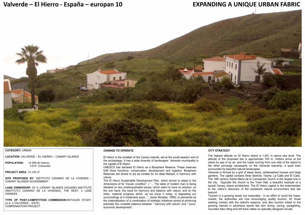
CATEGORY: URBAN LOCATION: VALVERDE – EL HIERRO – CANARY ISLANDS POPULATION: 10.558 (El Hierro) 4.914 (Valverde) PROJECT AREA: 13.135 m
2
SITE PROPOSED BY: INSTITUTO CANARIO DE LA VIVIENDA – CANARY ISLANDS GOVERNMENT LAND OWNERSHIP: 53 % CANARY ISLANDS HOUSING INSTITUTE (INSTITUTO CANARIO DE LA VIVIENDA). THE REST, 2 LAND OWNERS TYPE OF POST-COMPETITION COMMISSION:DETAILED STUDY. (U.A. 3 VALVERDE – ESTE) COMPENSATION PROJECT.
CHANGE TO OPERATE El Hierro is the smallest of the Canary Islands, set at the south-western end of the archipelago. It has a wide diversity of landscapes. Valverde municipality is the capital of El Hierro. UNESCO has declared El Hierro as a Biosphere Reserve. These reserves fulfil three functions: conservation, development and logistics. Biosphere Reserves are aimed to act as models for an ideal lifestyle, in harmony with nature. The El Hierro Sustainable Development Plan, which strives to adapt to the dimensions of its “insular condition”, ( “... The state of modern man is being debated on two unrelinquishable issues, which seem to have no solution: on the one hand, the need for harmony and balance with nature, and on the other, material progress which, as we know it today, is degrading our surroundings at a breakneck pace...”, Javier Morales, 1999), is perceived as the materialisation of a combination of strategic initiatives aimed at achieving precisely this unstable balance between “ harmony with nature” and “ socio-economic development”.
CITY STRATEGY
The highest altitude on El Hierro Island is 1,501 m above sea level. The altitude of the proposed site is approximate 700 m. Visitors arrive at the island by sea or by air, and the roads running from one side of the island to the other converge necessarily on the Valverde township, a quiet town surrounded by beautiful natural landscapes. Valverde is formed by a grid of steep lanes, whitewashed houses and large gardens. The capital contains three districts: Tesine, La Calle and El Cabo. The 18th century Santa María de la Concepción church is the largest one in the city. Opposite the church is the Town Hall, a beautiful example of a typical Canary Island architecture. The El Hierro capital is the antechamber to the visitor’s discovery of the exuberant natural environment that lies beyond. Tourism is a growing slowly but inexorably. In an effort to avoid the mass-market, the authorities are now encouraging quality tourism, for those seeking contact with the island's essence, and also tourism linked to the growing interest in adventure sports like skin diving, caving, paragliding, mountain bike riding and dirt track rallies on specially designed circuits.
VALVERDE – EL HIERRO – ESPAÑA - EUROPAN 10 EXPANSION OF A UNIQUE URBAN FABRIC
CATEGORY: URBAN LOCATION: VALVERDE – EL HIERRO – CANARY ISLANDS POPULATION: 10.558 (El Hierro) 4.914 (Valverde) PROJECT AREA: 13.135 m
2
SITE PROPOSED BY: INSTITUTO CANARIO DE LA VIVIENDA – CANARY ISLANDS GOVERNMENT LAND OWNERSHIP: 53 % CANARY ISLANDS HOUSING INSTITUTE (INSTITUTO CANARIO DE LA VIVIENDA). THE REST, 2 LAND OWNERS TYPE OF POST-COMPETITION COMMISSION:DETAILED STUDY. (U.A. 3 VALVERDE – ESTE) COMPENSATION PROJECT.
CHANGE TO OPERATE El Hierro is the smallest of the Canary Islands, set at the south-western end of the archipelago. It has a wide diversity of landscapes. Valverde municipality is the capital of El Hierro. UNESCO has declared El Hierro as a Biosphere Reserve. These reserves fulfil three functions: conservation, development and logistics. Biosphere Reserves are aimed to act as models for an ideal lifestyle, in harmony with nature. The El Hierro Sustainable Development Plan, which strives to adapt to the dimensions of its “insular condition”, ( “... The state of modern man is being debated on two unrelinquishable issues, which seem to have no solution: on the one hand, the need for harmony and balance with nature, and on the other, material progress which, as we know it today, is degrading our surroundings at a breakneck pace...”, Javier Morales, 1999), is perceived as the materialisation of a combination of strategic initiatives aimed at achieving precisely this unstable balance between “ harmony with nature” and “ socio-economic development”.
CITY STRATEGY
The highest altitude on El Hierro Island is 1,501 m above sea level. The altitude of the proposed site is approximate 700 m. Visitors arrive at the island by sea or by air, and the roads running from one side of the island to the other converge necessarily on the Valverde township, a quiet town surrounded by beautiful natural landscapes. Valverde is formed by a grid of steep lanes, whitewashed houses and large gardens. The capital contains three districts: Tesine, La Calle and El Cabo. The 18th century Santa María de la Concepción church is the largest one in the city. Opposite the church is the Town Hall, a beautiful example of a typical Canary Island architecture. The El Hierro capital is the antechamber to the visitor’s discovery of the exuberant natural environment that lies beyond. Tourism is a growing slowly but inexorably. In an effort to avoid the mass-market, the authorities are now encouraging quality tourism, for those seeking contact with the island's essence, and also tourism linked to the growing interest in adventure sports like skin diving, caving, paragliding, mountain bike riding and dirt track rallies on specially designed circuits.
Valverde–ElHierro‐España–europan10 EXPANDINGAUNIQUEURBANFABRIC
VALVERDE – EL HIERRO – ESPAÑA - EUROPAN 10 EXPANSION OF A UNIQUE URBAN FABRIC
CATEGORY: URBAN LOCATION: VALVERDE – EL HIERRO – CANARY ISLANDS POPULATION: 10.558 (El Hierro) 4.914 (Valverde) PROJECT AREA: 13.135 m
2
SITE PROPOSED BY: INSTITUTO CANARIO DE LA VIVIENDA – CANARY ISLANDS GOVERNMENT LAND OWNERSHIP: 53 % CANARY ISLANDS HOUSING INSTITUTE (INSTITUTO CANARIO DE LA VIVIENDA). THE REST, 2 LAND OWNERS TYPE OF POST-COMPETITION COMMISSION:DETAILED STUDY. (U.A. 3 VALVERDE – ESTE) COMPENSATION PROJECT.
CHANGE TO OPERATE El Hierro is the smallest of the Canary Islands, set at the south-western end of the archipelago. It has a wide diversity of landscapes. Valverde municipality is the capital of El Hierro. UNESCO has declared El Hierro as a Biosphere Reserve. These reserves fulfil three functions: conservation, development and logistics. Biosphere Reserves are aimed to act as models for an ideal lifestyle, in harmony with nature. The El Hierro Sustainable Development Plan, which strives to adapt to the dimensions of its “insular condition”, ( “... The state of modern man is being debated on two unrelinquishable issues, which seem to have no solution: on the one hand, the need for harmony and balance with nature, and on the other, material progress which, as we know it today, is degrading our surroundings at a breakneck pace...”, Javier Morales, 1999), is perceived as the materialisation of a combination of strategic initiatives aimed at achieving precisely this unstable balance between “ harmony with nature” and “ socio-economic development”.
CITY STRATEGY
The highest altitude on El Hierro Island is 1,501 m above sea level. The altitude of the proposed site is approximate 700 m. Visitors arrive at the island by sea or by air, and the roads running from one side of the island to the other converge necessarily on the Valverde township, a quiet town surrounded by beautiful natural landscapes. Valverde is formed by a grid of steep lanes, whitewashed houses and large gardens. The capital contains three districts: Tesine, La Calle and El Cabo. The 18th century Santa María de la Concepción church is the largest one in the city. Opposite the church is the Town Hall, a beautiful example of a typical Canary Island architecture. The El Hierro capital is the antechamber to the visitor’s discovery of the exuberant natural environment that lies beyond. Tourism is a growing slowly but inexorably. In an effort to avoid the mass-market, the authorities are now encouraging quality tourism, for those seeking contact with the island's essence, and also tourism linked to the growing interest in adventure sports like skin diving, caving, paragliding, mountain bike riding and dirt track rallies on specially designed circuits.

VALVERDE – EL HIERRO – ESPAÑA - EUROPAN 10 EXPANSION OF A UNIQUE URBAN FABRIC
SITE DEFINITION
Valverde is a scattered township composed primarily of permanent homes and the island's administration centre. It has three small districts, one at the top (Tesine), one in the middle (La Calle) and El Cabo at the bottom. The town is crossed by two main arteries and numerous steep lanes. It is proud not to have anything taller than three storey buildings or traffic lights, a luxury in today's world. The island has approximately 10,558 inhabitants, 4914 of which live in the Valverde municipality. The planning proposal for the study site currently envisages approximately 64 dwellings, which would generate a 3.9% population increase in the municipality. Bearing in mind that the population growth since 2004 in the Valverde municipality has been 1.5%, the project will bring relatively large-scale growth to its urban area. Most of the project area will be used for social housing. This is an extension of the urban area, and it must therefore be integrated into the existing urban fabric. There are four basic economic pillars of the island: Livestock grazing, fruit orchards, fishing and tourism. NEW URBAN MOBILITY Because this is the smallest island in the Archipelago, with just 278 km2, all distances are short. Distances from Valverde to the other main towns are:
Frontera: 31 Km, La Restinga: 34 Km, El Pinar: 18 Km, San Andrés: 10 Km, Sabinosa: 41 Km, Erese: 6 Km In 1972, the completion of works on the airport opened up El Hierro to air traffic and a new type of tourism. Three flights almost every day connect the island to Los Rodeos airport on Tenerife, and there is another flight to Gran Canary Island. El Hierro can be reached by plane from all the other islands on connecting flights via these two major airports. La Estaca harbour is a modern port that has recently been enlarged and improved. It can handle all sorts of ships, including cruise liners. NEW SOCIAL LIFE The location and the size of the proposed site give it several characteristics which could make it both a social and a physical landmark. Its location will make it part of the main frontage for visitors entering the town, and it the current design of the local road infrastructure makes it also an unavoidable point on the way to every other township on the island. In addition, its altitude above the sea makes it a lookout point.
NEW SUSTAINABILITY To define the new sustainable environment desired for the competition site, we shall briefly mention some strategic principles underlying the El Hierro Sustainable Development Plan: Nurture and enhance the island's natural environment, “... in such a way that it becomes more powerful, stable, rich and diverse...”. Develop and nurture the local culture. Advance towards self-sufficiency. Ensure quality in the end products. Social redistribution of the plan’s benefits. These principles should be reflected in a set of “fields of action” or strategic goals: Economic development of the island, supported in key sectors: agriculture, livestock grazing, fishing, rural/agro-tourism, local crafts and distribution of the island’s products. Special attention should be paid to “key elements” for the island's production of water, energy and materials, given that these are, “... necessary cycles for optimised usage and elimination of potential pollutants...”.
- o.
Valverde–ElHierro‐España–europan10
1
xxxxxxxxxxxxxxxxxxxxxxxxxxxxxxxxxxxxxxx
xxxxxxxxxxxxxxxxxxxxxxxxxxxxxxxxxxxxxxx
xxxxxxxxxxxxxxxxxxxxxxxxxxxxxxxxxxxxxxx
xxxxxxxxxxxxxxxxxxxxxxxxxxxxxxxxxxxxxxx
xxxxxxxxxxxxxxxxxxxxxxxxxxxxxxxxxxxxxxx
xxxxxxxxxxxxxxxxxxxxxxxxxxxxxxxxxxxxxxx
xxxxxxxxxxxxxxxxxxxxxxxxxxxxxxxxxxxxxxx
xxxxxxxxxxxxxxxxxxxxxxxxxxxxxxxxxxxxxxx
xxxxxxxxxxxxxxxxxxxxxxxxxxxxxxxxxxxxxxx
xxxxxxxxxxxxxxxxxxxxxxxxxxxxxxxxxxxxxxx
xxxxxxxxxxxxxxxxxxxxxxxxxxxxxxxxxxxxxxx
xxxxxxxxxxxxxxxxxxxxxxxxxxxxxxxxxxxxxxx
xxxxxxxxxxxxxxxxxxxxxxxxxxxxxxxxxxxxxxx
xxxxxxxxxxxxxxxxxxxxxxxxxxxxxxxxxxxxxxx
xxxxxxxxxxxxxxxxxxxxxxxxxxxxxxxxxxxxxxx
VALVERDE – EL HIERRO – ESPAÑA - EUROPAN 10 EXPANSION OF A UNIQUE URBAN FABRIC
CATEGORY: URBAN LOCATION: VALVERDE – EL HIERRO – CANARY ISLANDS POPULATION: 10.558 (El Hierro) 4.914 (Valverde) PROJECT AREA: 13.135 m
2
SITE PROPOSED BY: INSTITUTO CANARIO DE LA VIVIENDA – CANARY ISLANDS GOVERNMENT LAND OWNERSHIP: 53 % CANARY ISLANDS HOUSING INSTITUTE (INSTITUTO CANARIO DE LA VIVIENDA). THE REST, 2 LAND OWNERS TYPE OF POST-COMPETITION COMMISSION:DETAILED STUDY. (U.A. 3 VALVERDE – ESTE) COMPENSATION PROJECT.
CHANGE TO OPERATE El Hierro is the smallest of the Canary Islands, set at the south-western end of the archipelago. It has a wide diversity of landscapes. Valverde municipality is the capital of El Hierro. UNESCO has declared El Hierro as a Biosphere Reserve. These reserves fulfil three functions: conservation, development and logistics. Biosphere Reserves are aimed to act as models for an ideal lifestyle, in harmony with nature. The El Hierro Sustainable Development Plan, which strives to adapt to the dimensions of its “insular condition”, ( “... The state of modern man is being debated on two unrelinquishable issues, which seem to have no solution: on the one hand, the need for harmony and balance with nature, and on the other, material progress which, as we know it today, is degrading our surroundings at a breakneck pace...”, Javier Morales, 1999), is perceived as the materialisation of a combination of strategic initiatives aimed at achieving precisely this unstable balance between “ harmony with nature” and “ socio-economic development”.
CITY STRATEGY
The highest altitude on El Hierro Island is 1,501 m above sea level. The altitude of the proposed site is approximate 700 m. Visitors arrive at the island by sea or by air, and the roads running from one side of the island to the other converge necessarily on the Valverde township, a quiet town surrounded by beautiful natural landscapes. Valverde is formed by a grid of steep lanes, whitewashed houses and large gardens. The capital contains three districts: Tesine, La Calle and El Cabo. The 18th century Santa María de la Concepción church is the largest one in the city. Opposite the church is the Town Hall, a beautiful example of a typical Canary Island architecture. The El Hierro capital is the antechamber to the visitor’s discovery of the exuberant natural environment that lies beyond. Tourism is a growing slowly but inexorably. In an effort to avoid the mass-market, the authorities are now encouraging quality tourism, for those seeking contact with the island's essence, and also tourism linked to the growing interest in adventure sports like skin diving, caving, paragliding, mountain bike riding and dirt track rallies on specially designed circuits.

Valverde–ElHierro‐España–europan10

VALVERDE – EL HIERRO – ESPAÑA - EUROPAN 10 EXPANSION OF A UNIQUE URBAN FABRIC
VALVERDE – EL HIERRO – ESPAÑA - EUROPAN 10 EXPANSION OF A UNIQUE URBAN FABRIC
Puerto Port
Aeropuerto Airport
Valverde–ElHierro‐España–europan10