uva-dare (digital academic repository) residential ......ethnic preferences and residential...
TRANSCRIPT

UvA-DARE is a service provided by the library of the University of Amsterdam (http://dare.uva.nl)
UvA-DARE (Digital Academic Repository)
Residential segregation from the sixteenth to the nineteenth century: evidence from theNetherlands
Lesger, C.; van Leeuwen, M.H.D.
Published in:Journal of Interdisciplinary History
Link to publication
Citation for published version (APA):Lesger, C., & van Leeuwen, M. H. D. (2012). Residential segregation from the sixteenth to the nineteenthcentury: evidence from the Netherlands. Journal of Interdisciplinary History, 42(3), 333-369.
General rightsIt is not permitted to download or to forward/distribute the text or part of it without the consent of the author(s) and/or copyright holder(s),other than for strictly personal, individual use, unless the work is under an open content license (like Creative Commons).
Disclaimer/Complaints regulationsIf you believe that digital publication of certain material infringes any of your rights or (privacy) interests, please let the Library know, statingyour reasons. In case of a legitimate complaint, the Library will make the material inaccessible and/or remove it from the website. Please Askthe Library: https://uba.uva.nl/en/contact, or a letter to: Library of the University of Amsterdam, Secretariat, Singel 425, 1012 WP Amsterdam,The Netherlands. You will be contacted as soon as possible.
Download date: 06 Jun 2020
RESIDENTIAL SEGREGATION
Clé Lesger and Marco H. D. Van Leeuwen
Residential Segregation from the Sixteenth to theNineteenth Century: Evidence from theNetherlands Spatial segregation of the rich from the poor haslong attracted the attention of sociologists, geographers, and histo-rians, as well as politicians and concerned citizens. In nineteenth-century England, people even spoke of the “Two Nations”—thespatial separation of the bourgeoisie and the lower classes into sep-arate neighborhoods that made them complete strangers to oneanother. Today, the geographical concentration of the poor incertain urban neighbourhoods remains a source of concern. Segre-gated neighborhoods are believed to contribute to teenage preg-nancy, absence from school, unemployment, and criminality.Scholars with an optimistic view, however, stress that segregatedneighborhoods can foster ethnic cultural traditions and mutualsupport, and serve as a safe haven for minorities.1
Journal of Interdisciplinary History, xlii:3 (Winter, 2012), 333–369.
Clé Lesger is Associate Professor of Economic and Social History, University of Amsterdam.He is the author of The Rise of the Amsterdam Market and Information Exchange: Merchants, Com-mercial Expansion and Change in the Spatial Economy of the Low Countries, c.1550–1630 (Aldershot,2006); “Patterns of Retail Location and Urban Form in Amsterdam in the Eighteenth Cen-tury,” Urban History, XXXVIII (2011), 24–47.
Marco H. D. Van Leeuwen is Professor of Historical Sociology, Utrecht University. Heis the author of “Social Inequality and Mobility in History,” Continuity and Change, XXIV(2009), 399–419; with Ineke Maas, HISCLASS: A Historical Social Class Scheme (Leuven,2011).
The authors thank the editors of this journal, an anonymous referee, and participants atthe European Social Science History Conferences in Noordwijkerhout and Lisbon for com-ments on earlier versions of this article. They are also much indebted to Willem van den Bergand George Buzing for supplying data for Alkmaar and Delft, respectively, and to KateDelaney for translating the article from Dutch.
© 2011 by the Massachusetts Institute of Technology and The Journal of InterdisciplinaryHistory, Inc.
1 See David Ward, “Environs and Neighbours in the ‘Two Nations,’ Residential Differen-tiation in Mid-Nineteenth-Century Leeds,” Journal of Historical Geography, VI (1980), 133–162; Richard Dennis, English Industrial Cities of the Nineteenth Century (New York, 1984), 191–196, 214; Martin Gaskell, “Introduction,” in idem (ed.), Slums (Leicester, 1990), 1–16. Forscholars with an optimistic view, see, for example, Frederick W. Boal, “Ethnic ResidentialSegregation,” in David T. Herbert and R. J. Johnston (eds.), Social Areas in Cities (London,1976), 41–79; Gideon Bolt, Robert van Kempen, and Maarten van Ham, “Minority EthnicGroups in the Dutch Housing Market: Spatial Segregation, Relocation Dynamics andHousing Policy,” Urban Studies, XLV (2008), 1359–1384; M. C. Deurloo and Sako Musterd,“Ethnic Clusters in Amsterdam, 1994–96: A Micro Area Analysis,” ibid., XXV (1998), 385–396; K. M. Dunn, “Rethinking Ethnic Concentration: The Case of Cambramata, Sydney,”ibid., XXXV (1998), 503–524; Wenda van der Laan Bouma-Doff, “Involuntary Isolation:
Whichever viewpoint prevails, neighborhoods are clearlymore than the scenery against which social developments play out;they help to determine societal processes in the present day as theydid in the past. Yet, despite the resurgence of historical research onresidential segregation that geographical information systems (gis)have stimulated, studies of patterns and processes of residential spa-tial segregation in the past are few and far between, probably be-cause of the time-consuming nature of ªnding and processing therelevant information and the absence of land-register data and sur-veys before the nineteenth century. Our broad project on “Long-Term Residential Segregation” takes full account of the limita-tions of the early modern sources, aiming to develop an under-standing of residential segregation from the sixteenth ultimately tothe twentieth century. It uses evidence from the Netherlands—which even at the beginning of this period evinced relatively highlevels of urbanization and a variety of small, medium-sized, andlarge cities—to answer the following questions: (1) Which sourcespermit a gis study of residential segregation over the long term?(2) What exactly were the spatial patterns of residential segrega-tion, and how did they change over the long haul? (3) What fac-tors determined the spatial patterns of residential segregation, aswell as the long-term changes that they underwent?2
Our datasets for Alkmaar and Delft in the years 1632, 1733,and 1832 provide a good start to answering these questions. In thefuture, detailed data may well become available for other cities, in-
334 | CLÉ LESGER AND MARCO H. D. VAN LEEUWEN
Ethnic Preferences and Residential Segregation,” Journal of Urban Affairs, XXIX (2007), 289–309; Douglas S. Massey and Nancy A. Denton, American Apartheid: Segregation and the Makingof the Underclass (Cambridge, Mass., 1993); Musterd, Ruimtelijke segregatie en sociale effecten(Assen, 1996); idem, “Social and Ethnic Segregation in Europe: Levels, Causes, and Effects,”Journal of Urban Studies, XXVI (2005), 331–348; Chris Quispel, “‘Amerikaanse toestanden’ inNederland? Het debat over de onderklasse-problematiek,” Tijdschrift voor Sociale Geschiedenis,XXII (1996), 327–347; Camille Z. Charles, “The Dynamics of Racial Residential Segrega-tion,” Annual Review of Sociology, XXIX (2003) 167–207.2 For historical gis in general, see Onno Boonstra and Anton Schuurman (eds.), Tijd enruimte: Nieuwe toepassingen van GIS in de alfawetenschappen (Utrecht, 2009) (and the literaturecited therein); Ian N. Gregory, A Place in History: A Guide to Using GIS in Historical Research(Belfast, 2005); Anne K. Knowles, “Introduction: Historical GIS: The Spatial Turn in SocialScience History,” Social Science History, XXIV (2000), 451–470; idem, “Emerging Trends inHistorical GIS,” Historical Geography, XXXIII (2005), 7–13; for gis-based historical studies ofresidential segregation, Jason A. Gilliland, “Modelling Residential Mobility in Montreal,1860–1900,” Historical Methods, XXXI (1998), 27–42; idem, Sherry Olson, and DanielleGavreau, “Did Segregation Increase as the City Expanded? Montreal, 1881–1901,” Social Sci-ence History (2011, forthcoming); Marlou Schrover and Jelle van Lottum, “Spatial Concentra-
cluding Amsterdam, and for other years. Although the materialabout Amsterdam at this point is less detailed and complete thanthat about Alkmaar and Delft, it nonetheless is robust enough toindicate whether our ideas are tenable for a large city that experi-enced rapid population growth and expansion.3
Despite the paucity of gis-based studies of residential segrega-tion for such a long period, certain studies of contemporary socie-ties and even a few recent gis studies for the nineteenth centuryprove to be helpful for present purposes. So do older empiricalstudies of patterns and determinants of residential segregation,mostly at the neighborhood level. This literature contains valuableempirical and theoretical information about residential segregationthat still merits attention, even though gis promises unprece-dented analyses.4
residential segregation: classic and recent studies Thisoverview of residential segregation is based on studies of morethan a dozen early modern European cities. All of these studies usea quantitative indicator of residential segregation and includemaps. They differ greatly in sources, methods, periods, and focus.Most are mainly descriptive, providing occupational data, namesof the recipients of poor relief, and tax records, including dataabout the rental value of houses. Sometimes sources relate to aver-ages per district; at other times, they contain individual-level dataas grouped by a particular researcher. Studies cover either an entirepopulation or a single social group.5
RESIDENTIAL SEGREGATION | 335
tions and Communities of Immigrants in the Netherlands, 1800–1900,” Continuity andChange, XXII (2007), 215–252.3 Research on Belgian and British cities suggests a relationship between the growth and sizeof a city and its degree of segregation: Dominque Vanneste, De pré-industriële Vlaamse stad: eensociaal-economische survey: Interne differentiatie te Gent en te Kortrijk op het einde van de 18e eeuw(Leuven, 1987), 184; Colin G. Pooley, “Choice and Constraint in the Nineteenth-CenturyCity: A Basis for Residential Differentiation,” in J. H. Johnson and idem (eds.), The Structureof Nineteenth-Century Cities (London, 1982), 199–234, 202. For background data regardingAlkmaar, see Willem van den Berg, van Leeuwen, and Lesger, “Residentiële segregatie inHollandse steden: Theorie, methodologie en empirische bevindingen voor Alkmaar enAmsterdam, 16e–19e eeuw,” Tijdschrift voor Sociale Geschiedenis, XXIV (1998), 402–436; forDelft, Lesger, van Leeuwen, and George Buzing, “Residentiële segregatie in Delft: Eenverkenning van ruimtelijke patronen in 1832,” in Boonstra and Schuurman (eds.), Tijd enruimte, 52–61.4 For helpful nineteenth-century studies, see Vanneste, De pré-industriële Vlaamse stad;Pooley, “Choice and Constraint.”5 For early modern studies, see Elizabeth Baigent, “Assessed Taxes as Sources for the Study

Britain Seventeenth-century London contained three socio-economic elite quarters—one within the walled city near St.Paul’s; one outside the city near Whitehall, the governmentcenter; and an intermediate quarter, the Strand, with expensivemansions near the Thames. The poor lived near the city walls oroutside the walled city—for example, between St. Paul’s and theStrand. Macro-segregation, the location of different social groupsin different parts of town, was hardly the rule; meso-segregation—that is, “around the corner” segregation—was far more common.According to Jones, “streets of substantial houses often had lanesand alleyways of squalor immediately behind them. Lazarus wasliterally on Dives’ doorstep.”6
The same pattern existed, more or less, before and after theGreat Fire. The London socioeconomic elite preferred to live nearSt. Paul’s Cathedral because it was the communications hub forsocial and political news, and it was close to the stock exchange.Whitehall attracted not only government ofªcials but also artisansresponding to the demand for luxury goods. Data about the upperquarter of population at the close of the eighteenth century alsoshow the wealthy clustering in the inner city and near Westmin-ster. The untaxed poor lived mostly in the northern and easternperiphery. In accord with “around the corner” segregation, thewealthy lived in the squares and on the avenues, and these
336 | CLÉ LESGER AND MARCO H. D. VAN LEEUWEN
of Urban Wealth: Bristol in the Later Eighteenth Century,” Urban History Yearbook (1988),31–48; Emrys Jones, “London in the Early Seventeenth Century: An Ecological Approach,”London Journal, VI (1980), 123–133; John Langton, “Residential Patterns In Pre-IndustrialCities: Some Case Studies from Seventeenth-Century Britain,” Transactions of the Institute ofBritish Geographers, LXV (1975) 1–27 (on Exeter, Dublin, and Newcastle); Leonard D.Schwarz, “Social Class and Social Geography: The Middle Classes in London at the End ofthe Eighteenth Century,” Social History, VII (1982) 167–185; Jean-Pierre Bardet, Rouen auxXVIIe et XVIIIe siècles: Les mutations d”un espace social (Paris, 1983), 2 v.; G. Désert, “Immigra-tion et ségregation á Caen,” in Maurice Garden and Yves Lequin (eds.), Habiter la ville, xve–xxe siècle (Lyon, 1984), 175–191; Pierre Deyon, Amiens, capital provincial: Etude sur la sociétéurbaine au XVIIe siècle (Paris, 1967); Garden, Lyon et les Lyonnais au XVIIIe siècle (Paris, 1970);Hugues Neveux, “Economische transformatie en sociale segregatie: Het voorbeeld van eenNormandische stad: Caen in de 17e eeuw,” Tijdschrift voor Geschiedenis, XCIV (1981), 205–220; B. Bennassar, Valladolid au siècle d’or: Une ville de Castile et sa campagne au XVIe siècle (Paris,1967); Linda Martz, Poverty and Welfare in Habsburg Spain: The Example of Toledo (New York,1983); Etienne François, “Unterschichten und Armut in rheinischen Residenzstädten des 18.Jahrhunderts,” Vierteljahrschrift für Sozial und Wirtschaftsgeschichte, LXII (1975), 433–464 (onKoblenz); Johan Söderberg, Ulf Jonsson, and Christer Persson, A Stagnating Metropolis: TheEconomy and Demography of Stockholm, 1750–1850 (New York, 1991).6 Jones, “London in the Early Seventeenth Century,” 126.
“wealthy areas . . . generated their own poor hinterlands. Thewealthy required servants, porters, cooks, and washwomen inabundance; their presence attracted retailers, craftsmen, prosti-tutes, writers, criminals and many others.” Hence, the wealthywere a minority in every district in London.7
Tax assessments for Exeter, Dublin, and Newcastle in the lateseventeenth century show a similar pattern, but they also stress thatthe elite did not live in the center for only political and culturalreasons. Economic factors were inºuential, too: “A merchantclique was pre-eminent in wealth and municipal power. Its socialdominance was expressed geographically in the existence of amercantile quarter in that part of the city where its economic pur-poses were best served and where the institutions through whichthey dominated the city were located.” Tax data for the importantharbor town of Bristol in the later eighteenth century show thatthe rich merchants lived in the town center, and the poorerBristolians lived in the peripheral areas. All quarters, however, hadsome mix of rich and poor. By and large, this pattern had alreadybegun to emerge two centuries earlier.8
France The Rouen data show that the wealthy businessmenlived mainly, but not exclusively, in the middle of town, nearthe harbor, in both the sixteenth and eighteenth centuries. Thesixteenth-century poor inhabited each of the four quarters, butprimarily the eastern district. Detailed data for the early eight-eenth century conªrm and expand this picture: merchants gen-erally in the center (apart from the magistrates) and workers andartisans in the (predominantly eastern) periphery. Micro- or verti-cal segregation—that is, different social or ethnic groups living inthe same house but on different ºoors—was absent in Rouen, dueto small houses. Dangerous and malodorous activities were exiledto the outskirts, along with accompanying workers and artisans.But some degree of meso-segregation existed: “In the East, manu-facturing oblige[d] the master linen weaver to live near the cottonworkers, but even so, a ªne line distinguishe[d] the producers,well housed in the principal streets, from the proletariat lodged inthe inner courts and the small streets.”9
RESIDENTIAL SEGREGATION | 337
7 Schwarz, “Social Class and Social Geography,” 178.8 Langton, “Residential Patterns,” 21; Baigent, “Assessed Taxes.”9 Bardet, Rouen, I, 237–241 (quotation on 241 [our translation]); II, 57, 95–124.
338 | CLÉ LESGER AND MARCO H. D. VAN LEEUWEN
In Amiens, during the ªrst decades of the eighteenth century,the wealthy lived near the cathedral, especially in the southwest,and the paupers lived either in the western periphery near thewalls or in districts north of the cathedral where much of the man-ufacturing occurred. Textile workers were located at the edges oftown. Macro-segregation was clear: “The cartography of miserycorresponds to that of the tax contributions . . . as does an [analo-gous] photo to its negative.”10
Residential data about Caen are available for two periods.First is a tax list from the mid-seventeenth century. Despite thefact that certain tax districts present a blurred picture because oftheir size, a measure of macro-segregation is apparent. Socioeco-nomic elites occupied the central area, together with the artisanswho worked for them. Unskilled and textile workers lived in pe-ripheral districts. Two centuries later—when Caen was not yet in-dustrialized but was a regional center for trade and administration,as well as a place for well-to-do landowners to retire—its marriageand burial registers gave testimony to the same pattern. These re-cords also show that the peripheral areas contained houses with thelowest rent and of the lowest quality, and that these areas sufferedfrom the highest mortality rates. Interestingly, the data indicatethat they had a lower proportion of migrants than the more centralareas, since at that time, most migrants were white-collar andthus more privileged than ordinary working-class people fromCaen.11
Lyon in the second half of the eighteenth century offers aninteresting example of a city where new building activities gaveopportunities to change long-standing residential patterns. Manynew houses were built in the northwestern part of town, whererich merchants came to live and work. The old Lyonese nobilitycontinued to live in another part of town altogether. Silk workers,whose occupation was apparently noisy, were exiled to the pe-riphery, but, for the most part, the poor continued to live in theold houses. These dwellings were too small, and the streets toonarrow, to attract rich merchants. According to Garden, the eco-nomics of new construction furthered macro-segregation; since
10 Deyon, Amiens, capital provinciale, 247–252, 484, 543, 566 (quotation on 358 [our transla-tion]).11 Neveux, “Economische transformatie en sociale segregatie”; Désert, “Immigration etségregation á Caen.”

the ªnanciers and architects envisioned new buildings in whichsubstantial proªts would be possible, they rented them only tothose capable of paying the high rents.12
Other European Cities In sixteenth-century Toledo, districtswith the most charity recipients were on the edge of town, andthose with the wealthiest people, by number and proportion, werecentrally located. No district, however, was devoid of either richor poor inhabitants, and two of the poorest areas bordered two ofthe richest ones. Paupers in Vallodolid, during the same period,lived predominantly in the periphery, too, as did those in Koblenzat the close of the eighteenth century. Tax data show that Stock-holm displayed a similar pattern from the middle of that century tothe end of it.13
Taken together, these studies permit a number of conclusionsabout the patterns of residential segregation and the forces thatcreated them. On the macro-level of neighborhoods and districts,lower-income groups often occupied the peripheries of cities,whereas the well-to-do concentrated in the centers. But on themeso-level, the well-to-do settled into the main streets andsquares, whereas middle-class and lower-income groups took theside- and backstreets. The cited studies do not provide much in-formation about micro-segregation within the same house, butthis type of segregation occurred only in densely populated citiesthat offered plentiful accommodation in the form of ºats, or apart-ments.
A number of conditions were responsible for determining thepatterns of residential segregation:
Physical Environment. Harbors were natural places formerchants who operated at long distances to live, and spas werehighly attractive to the wealthy.
Occupational Structure. Malodorous tanneries and noisytextile industries usually ended up in remote sections of town, re-gardless of their resources.
Access to Transportation. Primitive means of transporta-tion, which were costly, time consuming, and otherwise unpleas-ant, placed a premium on living near the workplace, though only
RESIDENTIAL SEGREGATION | 339
12 Garden, Lyon et les Lyonnais, 204–210, 690–701.13 Martz, Poverty and Welfare in Habsburg Spain, 101–106, 134; Bennassar, Valladolid au siècled’or, 439; François, “Unterschichten und Armut,” 439–441; Söderberg, Jonsson, and Persson,Stagnating Metropolis, 93–122.
a relatively small proportion of a city’s inhabitants could afford topay for this privilege.
Social Distance. The greater was the social distance be-tween groups—as measured by wealth and ethnic status—whetherreal or perceived, the greater was the spatial distance betweenthem.
City Size and Building History. Large cities presented am-ple opportunity for segregation. More signiªcantly, segregationprocesses were “path-dependent.” A segregation pattern couldpersist even though the factors that shaped it had long sincechanged. Once mansions and slums had come into existence, per-sonal resources thenceforth determined who would live in them.Not even the wealthy could change residential patterns easily. Theªnancial or social costs of remodeling a group of houses or awhole quarter could be prohibitive. Territorial expansions andcatastrophic ªres that resulted in new construction, however, alsocreated new possibilities for segregation—either via the real-estatemarket (prices or rental values of houses) or through planning(ofªcial stipulations about residential eligibility).
Politics. Sometimes socioeconomic elites or middle classescould inºuence decision makers about the development of newareas, and sometimes poorer groups could effectively oppose thoseplans.
Sjoberg’s Pre-Industrial City These observations contain ele-ments of Sjoberg’s and Vance’s interpretations of the sociospatialstructure of pre-industrial cities. According to Sjoberg, in pre-industrial cities, “[a] small privileged upper class commands thekey positions in the political, religious, and educational structuresand exercises rather autocratic rule.” This elite class “sets the pacefor the total society,” which includes the “bulk of the populaceconsist[ing] of the lower class and outcaste groups.” In Sjoberg’spre-industrial city, economic activities lacked prestige. Merchants,for example, had low social status because of “[their] preoccupa-tion with money-making and other mundane pursuits that runcounter to the religious-philosophical value system of the domi-nant group.”14
Sjoberg’s understanding of social stratiªcation is reºected inthe clearly segmented physical layout of his pre-industrial city. All
340 | CLÉ LESGER AND MARCO H. D. VAN LEEUWEN
14 Gideon Sjoberg, The Pre-Industrial City, Past and Present (New York, 1960), 11,183.

of the important public functions and institutions, associatedmainly with the religious and political-governmental activities ofthe elite, were concentrated within the center of town. Some-times elements of the economic infrastructure, such as exchangesand market squares, were located there as well, but in a morpho-logical respect, these structures are clearly subordinate to thosewith religious or political signiªcance. The socioeconomic eliteoften established their homes there “to ensure ready access to theheadquarters of the governmental, religious, and educational or-ganisations,” as well as to transport facilities. Furthermore, theseelite members were in far less danger from bombardment and mil-itary attack than were the outcast groups closest to the city walls ortheir abutters. According to Sjoberg, the broad zone between thecenter and the periphery contained clusters of residents that dif-fered in ethnicity, profession, or religion, but otherwise shared thefact that they were not part of, or heir to the advantages of, thesocio-economic elite.15
Vance’s Capitalist City Vance’s notions differ drasticallyfrom Sjoberg’s. Sjoberg viewed industrialization in the nineteenthand twentieth centuries as the watershed between old and con-temporary segregation patterns. Vance dated this watershed forWestern Europe considerably earlier, in the sixteenth century,with the transition from precapitalist to capitalist societies and cit-ies. He characterized the precapitalist city as a place dominated bythe guilds where “order, proportion, and the maintenance of well-proven traditional practices were urban virtues.” Well-to-do mer-chants often occupied attractive locations bordering the marketsquare, but in the rest of the town, location was the result of occu-pational accident rather than rent-paying ability.16
Vance claimed that the high levels of competition, the “ap-praisal of the rent-productivity of land[,] and . . . ranking of loca-tion in economic terms” within the capitalist city had importantconsequences. First, the city center increasingly became the do-main of commercial parties, given its accessibility to the masses.Hence, merchants were willing to pay more to be located there.
RESIDENTIAL SEGREGATION | 341
15 Ibid., 95–107. See also Langton, “Residential Patterns,” for a summary and a comparisonwith the ideas of James E. Vance, Jr.16 Vance, “Land Assignment in the Pre-Capitalist, Capitalist and Post-Capitalist City,” Eco-nomic Geography, XLVII (1971), 101–120, 115–116 (quotation on 105). Vance does not citeSjoberg. See also Langton, “Residential Patterns.”

Second, the locus of work became separated from the home. Thepropertied classes in the capitalist cities went to live in newly builtresidential zones in the periphery (a phenomenon incidentallysimilar to the one that Vance must have observed in the cities ofthe United States) where they could obtain large tracts of land thatsuited their living preferences better than old buildings could. Theexodus of the rich eventually drew the middle and laboring classesto the vacuum in the center. The end result, according to Vance,was a pattern completely reversed from that sketched by Sjoberg,though both Vance and Sjoberg made a case for ethnic minoritieshaving their own districts (like the Jewish quarter) within thecity.17
The historical studies surveyed above do not support Vance’snotion of an exodus of elites from the core to the periphery ofearly modern cities; nor is there evidence for a sixteenth-centurywatershed between precapitalist and capitalist cities. But Sjoberg’sclaims about the low status of economic activities in European cit-ies are also untenable. Merchants could not only belong to the ur-ban elite; they sometimes dominated it. Economic functions oc-cupied more of the available space in the center than Sjobergthought possible. Elites may well have left the center to escapefrom the daily economic grind and to build large residences in anexpansive neighborhood at reasonable prices. They certainly didso in seventeenth-century Amsterdam. Although the weight ofhistorical evidence suggests that Vance’s theory is in need of revi-sion, its central element—the pivotal role of location, with pricesdetermined on a real estate market—has merit.
the problem of sources and methods Much of the vaguenessand conºict in the theories regarding residential segregation couldbe rectiªed by long-term empirical study. The rarity of suchempirical research is undoubtedly a consequence of its time-consuming nature, as well as the uncertainty about which sourcesto use and how to analyze them. Nonetheless, the factors thatinºuenced the development of residential patterns clearly includethe subjective preferences and objective characteristics of thoselooking for housing; the policies of government, banks, and realestate agents; and urban development in a particular city. Researchof the recent past usually turns on such socioeconomic features as
342 | CLÉ LESGER AND MARCO H. D. VAN LEEUWEN
17 Vance, “Land Assignment,” 107, 111–113.

income, wealth, and occupation. This study, however, treats therental value of a residence as an indicator of the socioeconomicposition of the household. This is a matter of pragmatic choicerather than principle. In segregation studies, it is desirable to haveall households—or at least a random sample of them—representedin the dataset since selective incompleteness can dramatically in-ºuence the outcome of a study. In the nineteenth century, sourceswith occupational information became available to fulªl this de-mand. For earlier periods, the source situation is much more lim-ited.
Generally, historians have referred to sources of a ªscal origin.Since early modern governments usually had no insight into theincome and actual wealth of their citizens, most taxes were basedon external signs of wealth, including the residence rented orowned. Hence, a relatively large amount of information aboutrental prices is available for early periods. The nature of the taxa-tion required that this information often be recorded topographi-cally, which is a condition for segregation research. The reasonsfor using rental information to do so, however, have other meritsas well. The choice of a speciªc residence represented both socialand economic considerations. A residence demonstrated socialstatus, either achieved or desired; members of a household pre-sented themselves to the outside world through their residence. Inaddition, rent expressed an inhabitant’s economic position—theprice that he was able and prepared to pay for a speciªc location.But considerations of social status were not the sole determinants;in the case of shopkeepers, merchants, and many others, accessibil-ity to production and trade within the urban grid was also impor-tant, as were subjective preferences. Hence, rental information isdeªnitely a strong indicator of residential segregation based on so-cial status and economic position, assuming that no redistributionmechanisms complicated the relationship between economic posi-tion and rent. The present-day Netherlands has individual rentalsubsidies; in the past, almshouses served a similar function, thoughthey are outside the scope of the study. Apart from almshouses,Dutch rental prices were determined by the free market accordingto the laws of supply and demand, justifying their use in thisstudy.18
Since the study of residential segregation is primarily about
RESIDENTIAL SEGREGATION | 343
18 For rental prices, see Lesger, Huur en conjunctuur: De woningmarkt in Amsterdam, 1550–1850(Amsterdam, 1986).
the spatial distribution of households according to speciªc charac-teristics, the location of householders’ residences must be ascer-tained as precisely as possible. Since 1832, the land register hasbeen the most useful tool for such matters in the Netherlands. TheLand Registry administers a large number of registers and maps, ofwhich two are of special importance for this study—the Oorspron-kelijke Aanwijzende Tafels (oat) and the Minuutplans, both from1832.19
The oat provide a property statement for every piece of landin the country—information about owner and type of building, aswell as surface area, class, and taxable income as of October 1,1832, when the land register opened in the Netherlands. The reg-istration of taxable income leads directly to the original purpose ofestablishing a land register—a uniform imposition of land tax.Rental value was not recorded, but it is easily calculated from thetaxable income.20
The Minuutplans, which are based on a detailed survey of theDutch territory, are essential for determining a plot’s location.These maps, like the oat, reºect conditions on October 1, 1832.The integrity of the the oat and the Minuutplans is maintainedthrough the stipulation that neither can be altered. The oat andthe Minuutplans are linked through the property statement (cadas-tral district and section and plot number). The Minuutplans servedas the basis for stylized maps of Alkmaar and Delft produced in1832. The houses in these cities are joined in blocks that nearly al-ways correspond to the smallest group of properties not divided bystreets or canals. To test our earlier assumption that pre-industrialcities were characterized by mixing on the neighborhood leveland segregation on the street level, analysis at the block level willnot sufªce; instead, each block was divided into “faces.”21
344 | CLÉ LESGER AND MARCO H. D. VAN LEEUWEN
19 Lesger, Van Leeuwen, and Buzing, “Residentiële segregatie in Delft.” See also F. Kever-ling Buisman and E. Muller, “Kadaster-Gids”: Gids voor de raadpleging van hypothecaire enkadastrale archieven uit de 19e en de eerste helft van de 20e eeuw (The Hague, 1979); idem, Op goedegronden: Een bundel opstellen ter gelegenheid van het 150-jarige bestaan van de dienst van het Kadasteren de Openbare Registers (Dienst van het Kadaster en de Openbare Registers) (The Hague,1982).20 Public buildings and publicly run almshouses were tax-exempt. Van den Berg andBuzing graciously offered digital ªles for Alkmaar and Delft, respectively, and helped withtheir interpretation. The original registers and maps for Alkmaar are located at theRijksarchief Noord-Holland (North Holland Public Records Ofªce) in Haarlem, and forDelft at the Nationaal Archief (National Archive) in The Hague.21 The gis program MapInfo was used to present and analyze the material. A block did notrepresent the smallest division wherever it was divided by a lane or alley without property en-
During the Ancièn Régime, real estate was also a naturalsource for taxation. In the west of Holland, the verponding, a taxbased on the rental value of houses and land, was instituted duringthe early days of the Republic. But the years 1632 and 1733, whenit was “redressed” or adjusted, are of particular importance, sincethey provide up-to-date tax information based on changes in rentsnot previously recorded.22
Unfortunately, the adjustments to the verponding of 1632have not been preserved for any place in Holland, but those of1733 have. They are arranged topographically, reporting type ofbuilding, name of owner, rent according to the rental contract,and the assessment of the old and new verponding for eachpiece of property. Because they list both the old and new rentalvalues, they offer a reasonable image of the rental amounts ªxedin 1632—certainly in Alkmaar where the urban developmentalstructure did not change much in the intervening period.23
Van den Berg succeeded in matching three-quarters of theproperty statements in the 1733 register of Alkmaar with the prop-erty statements in the 1832 land register. A nearly complete matchwas attainable at the level of block faces—the most detailed re-search unit in this study. Despite the high quality of the data, how-ever, a number of speciªc problems remain. The reliability of thedata is weakest for 1632; we must be satisªed with the informationabout tax values in 1632 as recorded in the readjustment of 1733.In 1632, however, Alkmaar had more residences, and more peo-ple, than it had a century later. Practically no houses were demol-ished in the period between the readjustment of 1632 and that of1733. The roughly 4,000 more inhabitants of the city in 1632 musthave lived in spaces that the adjustment of 1733 designated as
RESIDENTIAL SEGREGATION | 345
trances and wherever multiple noncontinuous plots (mostly business buildings) were com-bined into a single block.22 The rental value of housing in Amsterdam varied signiªcantly over time (Lesger, Huur enconjunctuur, 181–182 [graphs 1 and 2]).23 See the Nationaal Archief, Financie Holland, inv.nr. 515, for the Alkmaar register andinv.nr. 492, for Delft. In cases without a rental contract because the resident was also theowner, we estimated rental value to serve as a base for the tax. In shared housing, rental valuewas usually reported for each individual residence within a property. For a reasonable idea ofrental amounts, see also van den Berg and Jan Luiten van Zanden, “Vier eeuwen welstand-songelijkheid in Alkmaar, ca 1530–1930,” Tijdschrift voor Sociale Geschiedenis, XX (1993), 193–215, 207–208. The four neighborhoods into which Alkmaar was then divided reported almostidentical amounts of verponding tax in 1632, 1718, and 1730 (just before the readjustment).

sheds, stables, carriage houses, warehouses, rooms, and kitchens.In 1733, these structures were generally registered as part of a resi-dence; a century earlier, a large number of them were independ-ent living quarters. The decrease in population resulted in an in-creased use of space per household. This article’s reconstruction ofAlkmaar’s sociospatial structure in 1632 assumes that all of thosesmall buildings registered in the readjustment of 1733 as attachedto residences served as residences themselves in 1632.24
The research method used in this study is simple and easilyreplicable. The ªrst step in the analysis for each reference year wasthe selection of assessable units—residences with known rents,excluding almshouses. The rental values of these residenceswere then arranged in order of size and divided into four equalgroups—quartiles. Once quartile parameters for the year in ques-tion were determined, each block and block face could be as-signed to one of the quartiles based on average rent. The ªrstquartile comprises blocks and block faces with average low rents;the second and third quartiles comprise blocks and block faceswith average mean rents; and the fourth quartile comprises blocksand block faces with average high rents.
Since the division into quartiles involved relative measure-ments—that is, the same ratio holding for the total population ofrental values—the outcomes for the three reference years (1632,1733, and 1832) were easily compared. This strategy allowed us toevaluate the importance of path dependency: Did the large lotsand costly buildings deªne and reinforce the location of elite resi-dences over time, while the cellars, garrets, and small buildingswere relegated to everyone else? Were subsequent generationsforced into this stable segregation, regardless of their preferences,because no major technological advance or catastrophe everforced the city to begin anew as a tabula rasa? To uncover possiblesubtle changes that our indicator, rental value, does not reveal, wealso consulted a few additional sources—formal addresses of thepolitical elite in Alkmaar and of the wealthy elite in Amsterdam, aswell as scattered, anecdotal remarks by contemporaries.25
346 | CLÉ LESGER AND MARCO H. D. VAN LEEUWEN
24 The ªnal sentence is an overestimate. However, an analysis of the situation in 1632 withthe extreme assumption that none of these buildings was used as housing made little observ-able difference in the maps.25 We are grateful to the JIH referee for a concise formulation of this issue.

residential segregation in alkmaar and delft
Alkmaar After mapping rental values for the whole city ac-cording to the procedure just presented, we discovered that nineblocks (including the Grote Kerk, or Great Church) do not meetthe criteria for inclusion in the analysis of residential segregationfor 1632. The problem is greatest in the northwestern corner ofthe city where the social-services institutions—not assessed in theverponding—are concentrated. A number of the blocks therewere also more commercial than residential.26
Figure 1 summarizes information about the estimated rentalvalue of 2,392 residences in Alkmaar c. 1632. The lowest yearlysingle rent for a residence was four guilders, and the highest was488 guilders. Though obviously less extreme, the differences inaverage rent per block are still palpable, and they are clearly ex-pressed on the map. A single glance reveals that blocks with an av-erage high rent (dark colored on the map � fourth quartile) arenot randomly spread around the city but instead form anunmistakeable pattern. A band of average-high-rent blocks movesfrom the Grote Kerk in a southeasterly direction to the Mient,which also features high rental values. From the Mient, the expen-sive buildings continue in a southeasterly direction along twoaxes—Luttik Oudorp in the north and, to a lesser extent, Ver-dronken Oord in the south. Extending from the Mient, anothershort axis runs along the Waagplein in a northerly direction. Thispattern is even more pronounced in the blocks of average rents inthe third quartile: The highest rents fall along the long axes in thecity, connected by a north–south band in the geographical centerof Alkmaar. The blocks with average low rents are largely—butnot exclusively—found primarily in the northwestern and south-eastern peripheries.
A broad consideration of Figure 1 reveals that an analysis oflarger-scale neighborhoods rather than smaller blocks would havemissed a ªner pattern of segregation. In fact, an analysis conductedat the deeper level of block faces reveals ªne-grained patterns ofsegmentation hidden behind what at ªrst glance appear to be ho-mogeneous blocks (Figure 2). Most of the blocks evince consider-
RESIDENTIAL SEGREGATION | 347
26 Among the requirements for inclusion was the condition that half of the lots within ablock be made up of residences. The blocks in the northwestern corner were largely occupiedby a horse market, stables, and roperies. The city carpenter’s yard was in the southeastern cor-ner of Alkmaar.
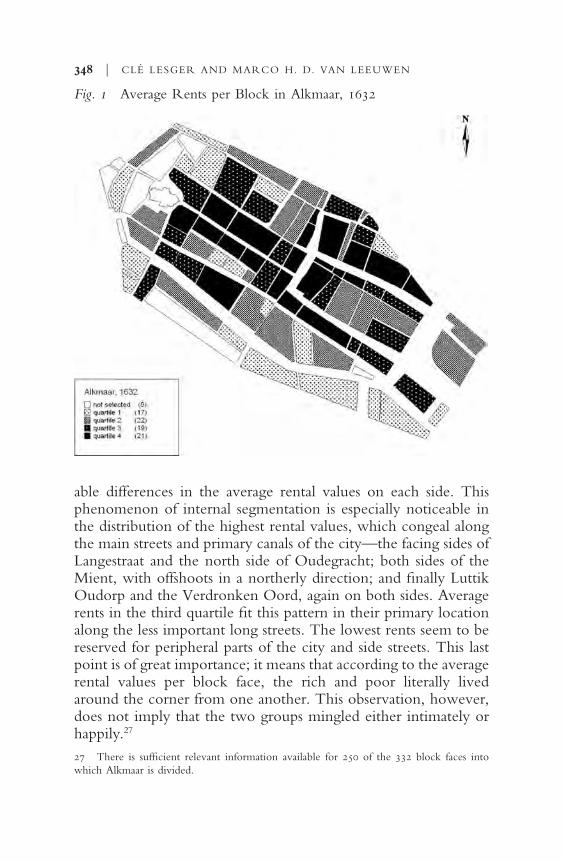
able differences in the average rental values on each side. Thisphenomenon of internal segmentation is especially noticeable inthe distribution of the highest rental values, which congeal alongthe main streets and primary canals of the city—the facing sides ofLangestraat and the north side of Oudegracht; both sides of theMient, with offshoots in a northerly direction; and ªnally LuttikOudorp and the Verdronken Oord, again on both sides. Averagerents in the third quartile ªt this pattern in their primary locationalong the less important long streets. The lowest rents seem to bereserved for peripheral parts of the city and side streets. This lastpoint is of great importance; it means that according to the averagerental values per block face, the rich and poor literally livedaround the corner from one another. This observation, however,does not imply that the two groups mingled either intimately orhappily.27
348 | CLÉ LESGER AND MARCO H. D. VAN LEEUWEN
Fig. 1 Average Rents per Block in Alkmaar, 1632
27 There is sufªcient relevant information available for 250 of the 332 block faces intowhich Alkmaar is divided.

Figures 3 and 4 contain information about the rental values of2,200 of the city’s residences in 1733 and 1,883 of them in 1832.The rich and the poor continued to live in close proximity to eachother at these junctures, and the segmentation evident in 1632 onthe street level remained, though still invisible at a higher level.Yet, the picture is not completely static. High-value buildingsalong Luttik Oudorp and the Verdronken Oord had clearly re-treated further west. Indeed, residences with the greatest rentalvalue disappeared from a large section of the eastern side of thecity. Only residences on the north side of Luttik Oudorp and onthe Bierkade maintained their status. Judging from the buildingsaround the Waag and the northern city gate, the top socioeco-nomic stratum seemed to have withdrawn from the periphery,though no sign of increased homogeneity in the center of town isevident.28
RESIDENTIAL SEGREGATION | 349
28 Again, certain blocks and block faces did not qualify for the analysis because of the prom-inence of social-service institutions and commercial spaces.
Fig 2 Average Rents per Block Face in Alkmaar, 1632

Delft Can the situation in pre-industrial Alkmaar be trans-posed elsewhere? Delft, like most towns in Holland, showed rapideconomic and demographic growth during most of the seven-teenth century, decline from the latter part of the seventeenth tothe mid-eighteenth century, stabilization or a slight upturn after1750, severe distress during the French era, and cautious recoveryduring the ªrst half of the nineteenth century. The city probablyachieved its peak population of 24,000 c. 1680. In 1749, the popu-lation decreased to about 14,000, the number registered in the ªrstreal census of 1795, and in 1815, to 12,300, before rising to morethan 15,000 in 1832. By 1830, however, the city had lost much ofits industrial luster (its beer brewery and ceramics industry). At thattime, Delft functioned primarily as a center of government andsocial services for the surrounding countryside. Artisans, shop-keepers, traders, and service personnel dominated the urban laborforce. A considerable number of other people found work in thedepartment of war’s artillery factories. Delft’s reputation as a
350 | CLÉ LESGER AND MARCO H. D. VAN LEEUWEN
Fig. 3 Average Rents per Block Face in Alkmaar, 1733
sleepy, stagnant town persisted at least until the middle of thenineteenth century.29
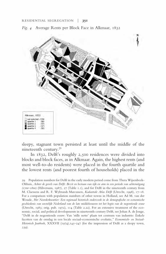
In 1832, Delft’s roughly 2,500 residences were divided intoblocks and block faces, as in Alkmaar. Again, the highest rents (andmost well-to-do residents) were placed in the fourth quartile andthe lowest rents (and poorest fourth of households) placed in the
RESIDENTIAL SEGREGATION | 351
29 Population numbers for Delft in the early modern period come from Thera Wijsenbeek-Olthuis, Achter de gevels van Delft: Bezit en bestaan van rijk en arm in een periode van achteruitgang(1700–1800) (Hilversum, 1987), 27 (Table 1.1), and for Delft in the nineteenth century fromM. Claessens and R. F. Wybrands Marcussen, Kadastrale Atlas Delft (Utrecht, 1998), 17–18.For a comparison with population numbers of other towns in Holland, see Ad M. van derWoude, Het Noorderkwartier: Een regionaal historisch onderzoek in de demograªsche en economischegeschiedenis van westelijk Nederland van de late middeleeuwen tot het begin van de negentiende eeuw(Utrecht, 1983; orig. pub. 1972), 114 (Table 2.22). For an extensive treatment of the eco-nomic, social, and political developments in nineteenth-century Delft, see Johan A. de Jonge,“Delft in de negentiende eeuw: Van ‘stille nette’ plaats tot centrum van industrie: Enkelefacetten van de omslag in een locale sociaal-economische evolutie,” Economisch- en Sociaal-Historisch Jaarboek, XXXVII (1974),145–247 (for the impression of Delft as a sleepy town,239).
Fig. 4 Average Rents per Block Face in Alkmaar, 1832

ªrst quartile. The result of this procedure can be seen in Figure 5.To simplify orientation, canals and streets have been indicated.The houses along town ramparts have been combined and theiraverage rental value is presented in the horizontal bar in the lowerright side of the ªgure, just outside Delft’s defenses.
The ªgure clearly shows the blocks with the highest averagerent (quartile 4) not to be spread randomly throughout the city butconcentrated in the western part. In essence, the high-rent hous-ing blocks were on either side of the two canals that cut throughDelft from north to south—the Oude Delft and the Noordeindewest of the Oude Kerk (Old Church) and the Voorstraat-Koornmarkt stretch east of the church. Residential blocks with
352 | CLÉ LESGER AND MARCO H. D. VAN LEEUWEN
Fig. 5 Average Rents per Block in Delft, 1832
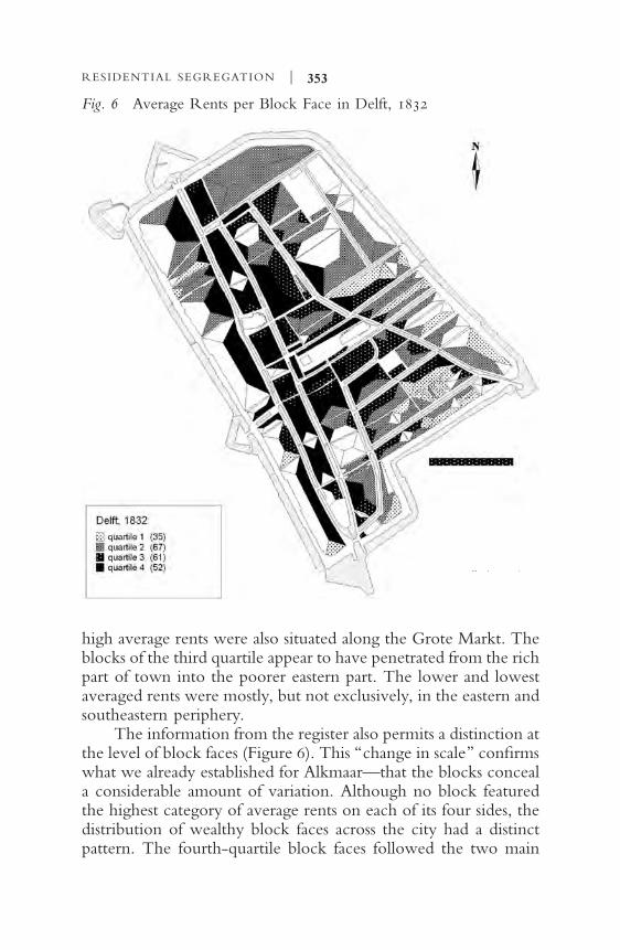
high average rents were also situated along the Grote Markt. Theblocks of the third quartile appear to have penetrated from the richpart of town into the poorer eastern part. The lower and lowestaveraged rents were mostly, but not exclusively, in the eastern andsoutheastern periphery.
The information from the register also permits a distinction atthe level of block faces (Figure 6). This “change in scale” conªrmswhat we already established for Alkmaar—that the blocks conceala considerable amount of variation. Although no block featuredthe highest category of average rents on each of its four sides, thedistribution of wealthy block faces across the city had a distinctpattern. The fourth-quartile block faces followed the two main
RESIDENTIAL SEGREGATION | 353
Fig. 6 Average Rents per Block Face in Delft, 1832

canals in the western part of the city, along the Grote Markt, alsocropping up in other parts of the city, particularly near canals. Theblock faces with an average rent in the third quartile also con-formed to this pattern, hugging the canals and also appearing inthe side streets that cut through the well-to-do main canals. Therents were also relatively high in the areas surrounding the majorcity gates. The block faces with average rents in the lowest quartilewere more widely distributed than an analysis at the block levelwould suggest. Relatively cheap housing abounded primarily inthe eastern and southeastern parts of the city. The shallow depth ofthe blocks suggests that the houses therein were small. Southeast-ern Delft, in particular, featured a series of narrow streets andsmall residences. Small houses could also be found in the enclosedareas reachable from the street through narrow alleys. However,the wealthy western part of the city also contained block faceswith average rents from the lowest quartile—for example, theside streets between the west end of Oude Delft and the cityramparts.30
This examination of the residential patterns in Alkmaar andDelft establishes four main points: (1) In researching residentialpatterns in pre-industrial towns, the analysis must take place at thelevel of the block face. Such analysis shows that Alkmaar and Delfthad no wealthy neighborhoods or wealthy blocks, only wealthyblock faces, though the lowest rental class shows some homogene-ity at the block level, primarily on the periphery of town. None-theless, an analysis of the cheap residences at the level of theneighborhood or block is susceptible to erroneous conclusions.Only at the block-face level is it clear that the poor were also dis-tributed widely in areas outside of the peripheral neighborhoods.In both Alkmaar and Delft, they even lived in the immediate vi-cinity of the wealthy. Scholars have often surmised that a great de-gree of residential mixing occurred in pre-industrial cities, but thisstudy demonstrates it concretely.
(2) With regard to the previous point, neither Alkmaar norDelft ever had a compact elite quarter. Residents with an elevatedsocioeconomic status were dispersed along axes that were formedthrough linked series of block faces, each with (average) high-value buildings.
354 | CLÉ LESGER AND MARCO H. D. VAN LEEUWEN
30 A minimum of three distinct divisions per block face was required for inclusion on themap.

(3) Research on Alkmaar suggests that the residential patternsmentioned above persisted for the entire pre-industrial period.Notwithstanding minor contingencies, segregation at the streetlevel, which largely saw the wealthy occupying speciªc mainstreets and the poor occupying side streets and alleys, remained infull force throughout the period.
(4) Finally, the well-to-do segment of Alkmaar’s populationeventually withdrew from the eastern part of the city. The centerof town, however, did not thereby acquire a more homogeneouscharacter due to the inºux of wealthy residents.
an explanation of patterns and developments during the
era Which of the earlier-mentioned theories of residential seg-regation ªt the situation in relatively small Dutch cities likeAlkmaar and Delft? Clearly, the internal segmentation of blocksand the mix of the wealthy and poor at the street level does not ªtSjoberg’s ªxed model of segregation in the pre-industrial city. Noris one common explanation for the high degree of social-spatialmixing in pre-industrial cities—the friction of distance—especiallycogent. Since an early modern city like Alkmaar or Delft could becrossed by foot from north to south or from east to west in just halfan hour, the daunting prospect of long-distance interaction couldnot be responsible for the mixing of social classes there.31
According to real-estate economists, location is almost theonly thing that matters in real estate. Many of them view locationas the driving force behind segmentation in Western cities duringthe late nineteenth and twentieth century. Vance is one of the fewscholars who emphasizes the utility value of land and the operationof the real-estate market in early modern cities, too. City real es-tate typically evinces sharp differences in price at short distances.Accessibility via through-streets and arterial roads—and the pricethat users of the land are prepared to pay for it—always came at apremium. The peace and quiet and the aura of status that certaincanals and streets could offer also generated high prices. Side andback streets—sometimes only a few meters from the more prized
RESIDENTIAL SEGREGATION | 355
31 According to some scholars, many early modern cities were “walking cities” only; thelack of cheap and efªcient transport severely limited the distances that people were able andwilling to travel. Because the middle and lower classes were dependent on the rich for work,and the rich were dependent on the services and consumer goods that the middle and lowerclasses provided, the mixing of social classes was inevitable.
locations—lacked the advantages of prime location and its atten-dant high cost. Thus, the housing there was usually within reachof the middle groups and lower strata of society, even though notgeographically distant from that of the elite. In other words, themarket for real estate, not the friction of distance, allowed the var-ious groups to live in proximity to each other.
The importance of accessibility via thoroughfares and con-necting roads offers an explanation for a second ªnding of thisstudy—the lack of a compact elite quarter. Those whose liveli-hoods required such accessibility tended to settle in places wheremany people either gathered (Alkmaar’s Waagplein and the GroteMarkt in Delft) or passed (along streets leading to the center ornear the city gates—that is, along certain luxury axes within thecity). Other city dwellers, who had to be content with a less opti-mal location, lived around the corner on side and back streets.
Well-to-do residents who preferred a more peaceful residen-tial setting away from the crowds would conceivably havebeneªted from a compact elite quarter. Those in Alkmaar andDelft, and in other Dutch cities like them, however, had no suchquarter because of their relatively small numbers and the geo-graphical circumstances under which they lived. The canals thatstretched across much of the full length and breadth of Dutch cit-ies were vital to water management, both inside and outside thecity. The well-to-do traditionally chose the large plots of land,with their panoramic views, along these broad canals. Given suchan environment and enough luxury buildings to satisfy their de-mand, they had no need for a small neighborhood of their own,which not only would have required considerable investment butalso would have led to the destruction of capital along the alreadyexisting luxury axes. Continuity of the existing pattern was themost natural course, creating path dependency—the reason for theremarkable continuity of residential patterns.
What still requires explanation is the fact that well-to-doAlkmaar residents gradually withdrew from the eastern part of thecity. The explanation begins in the Middle Ages when the city wasnot yet half the size that it reached in 1632, and only the westernpart of the city was constructed. Situated on high ground and fac-ing the Voormeer Lake, Alkmaar in the Middle Ages served as amilitary base for the counts of Holland in their struggles againstopponents from West Friesland. It was also the northern entrance
356 | CLÉ LESGER AND MARCO H. D. VAN LEEUWEN
to the heart of Holland. Pending further research, the defeat andpaciªcation of the West Frisians probably offered new commercialpossibilities for Alkmaar at the spot where land and water met—the banks of the Voormeer Lake.
The commercial center remained in the area near theVoormeer Lake as the city spread out geographically. At the end ofthe ªfteenth century, people began to move into the eastern partof the city: The canals Luttik Oudorp and Verdronken Oordstretched in an easterly direction until, at the end of the sixteenthcentury, Alkmaar reached the size and structure that it wouldmaintain for three centuries. Due to large-scale land reclamationin the ªrst half of the seventeenth century, however, LuttikOudorp and Verdronken Oord were no longer access points toopen water but instead opened onto spacious farm land in the newpolders. The sociospatial map of Alkmaar in 1632 provides a snap-shot from this dynamic period. The city became more and moreeconomically focused on the rich surrounding farm land, asreºected in the settlement patterns of the elite. The old commer-cial center of the Mient and Waagplein and the access roads to thiscenter were long, linked stretches of block faces with high averagerents. The old religious and political center of the city occupiedthe high ground around the Grote Kerk and the Langestraat,which connected it with the newer economic center.32
However, starting in the second half of the seventeenth cen-tury, Alkmaar showed a downward demographic trend—a popu-lation drop of at least 40 percent, to fewer than 10,000 inhabit-ants—closely linked to the economic and demographic crisestaking place in the countryside in North Holland. Agriculturalproducts at that time were in short supply in Alkmaar, and the de-mand for manufactured products and services in the surroundingarea decreased. At a time of economic and geographical expan-sion, Luttik Oudorp and Verdronken Oord, which had acquiredsome of the functions associated with the old commercial centeraround Mient and Waag, were the ªrst arms of the urban organ-ism to suffer degeneration during the crisis. The canals lost theirprestige as top locations. Thus did the size of Alkmaar’s commer-
RESIDENTIAL SEGREGATION | 357
32 Notwithstanding Sjoberg’s relatively simple concentric model, the city’s sociospatialstructure was not always solely determined by an exclusive political-religious elite. In the east-ern part of Alkmaar, economic considerations inºuenced the locational decisions of the well-to-do, manifested in the geographical structure of the city.

cial center adjust in response to the decreased supply and demandfrom surrounding area.33
The political-governmental function of the city remained un-affected, however. Although the population in the city and its en-virons dramatically decreased, the size of the bureaucracy re-mained at the level of the ªrst half of the seventeenth century—roughly 270 positions. In the second half of the eighteenth and theªrst half of the nineteenth century, this bureaucracy even in-creased to 288 and 356 positions, respectively, and, as a conse-quence, the political-governmental center around the Grote Kerkand in the Langestraat did not lose its signiªcance. This center alsoremained the favored living quarters of the political-governmentalelite. Thirty of the thirty-seven addresses of mayors and city-council members from 1730 to 1740 were in the western part ofthe city, and only seven were in the eastern part (mainly in theVerdronken Oord and along the Bierkade).34
Incidentally, the political elite had a decided preference forthe Langestraat. Six of the eight mayors and twelve of the twenty-nine city-council members lived there. Given the assumption thatthe Oudegracht and Koorstraat were part of the old political-religious center of the city, all of the mayors and nineteen of thetwenty-nine city councilors lived there. Around 1830, the politicalelite were still largely concentrated in the center of town: Twenty-two of the thirty-one men who served as mayors, aldermen, andcity councilors from 1830 to 1840 lived there. Luttik Oudorp,Verdronken Oord, and Bierkade were rarely the domain of thepolitical elite; the Langestraat, which boasted eighteen dignitaries’addresses, had become even more popular.
findings and speculations about residential segregation in
amsterdam Considering the fact that most early modern cities
358 | CLÉ LESGER AND MARCO H. D. VAN LEEUWEN
33 See van der Woude, “De contractiefase van de seculaire trend in het Noorderkwartiernader beschouwd,” Bijdragen en Mededelingen betreffende de Geschiedenis der Nederlanden (1988),373–398; Jan de Vries and idem, The First Modern Economy: Success, Failure, and Perseverance ofthe Dutch Economy, 1500–1815 (New York, 1997), 673–687; van Zanden, “De economie vanHolland in de periode 1650–1805: groei of achteruitgang? Een overzicht van bronnen,problemen en resultaten,” Bijdragen en Mededelingen betreffende de Geschiedenis der Nederlanden,CII (1987) 562–609; Piet Boon, Bouwers van de zee: zeevarenden van het Westfriese platteland,c.1680–1720 (The Hague, 1996); Lesger, Hoorn als stedelijk knooppunt: Stedensystemen tijdens delate middeleeuwen en vroegmoderne tijd (Hilversum, 1990), 122–177.34 The number of positions in the bureaucracy was calculated on the basis of Jos C. N.

in Holland were fairly small, our choice of Alkmaar and Delft torepresent long-term residential segregation there is justiªed.However, the image is not complete without a look at Amster-dam, a much larger city, which experienced population growth inthe pre-industrial period comparable to that of cities in the nine-teenth century. In 1580, Amsterdam, with roughly 30,000 inhabit-ants, was a mid-sized European city. In the next century, however,the city grew to more than 100,000 inhabitants in 1622 and morethan 200,000 in 1680. From the middle of the seventeenth cen-tury, Amsterdam belonged to the select group of large Europeancities. Its demographic growth could not be conªned within itsold, medieval conªguration. At the end of the sixteenth century,the town began several phases of intense expansion that make it anideal place to study the processes of residential segregation in atown substantially larger than Alkmaar and Delft.35
Although our maps of Amsterdam are as yet unªnished, wecan identify a number of major trends based on current research,beginning with the city’s medieval and sixteenth-century segrega-tion pattern. At that time, the primary axes in Amsterdam weretwo river embankments—Warmoesstraat and Nieuwendijk thatnot only provided access to the surrounding countryside but also,along with the Dam, formed the border of the old inner harbor ofthe city (Damrak). Until the end of the sixteenth century,Warmoesstraat remained one of the city’s most important streetsand the home of the economic elite who dominated the city’sgovernment at the time. Middle and poor groups occupied theimmediate surroundings of the well-to-do in the side streets andalleys off the main arteries, but not exclusively in these areas. LikeAlkmaar and Delft, Amsterdam had a disproportionate number ofpoor residents on its peripheries, many of them at or near the citywall—an area that was far more dangerous during attack than thebetter locations in the harbor and the access roads to the country-side. Around 1560, Amsterdam had a sociospatial structure similarto that of Alkmaar c. 1632. What happened, then, at the end of thesixteenth century when the economy experienced a phase of un-
RESIDENTIAL SEGREGATION | 359
Raadschelders, Plaatselijke bestuurlijke ontwikkelingen 1600–1980: een historisch-bestuurskundigonderzoek in vier Noord-Hollandse gemeenten 1600–1980 (The Hague, 1990), 295 (Table 2).35 Van Leeuwen and James E. Oeppen, “Reconstructing the Demographic Regime ofAmsterdam 1681–1920,” Economic and Social History in the Netherlands, V (1993), 61–102.
precedented growth, masses of migrants settled in the city, and thepopulation curve rose steeply?
The economic and migratory boom that transpired at the endof the sixteenth century put enormous pressure on Amsterdam’savailable space, especially in the heart of the city where economic,political, and religious life was concentrated. This section of thecity contained the inner harbor, the exchange, the weigh house,and markets, as well as the primary shopping streets, the inns forvisitors, and the ofªces of the many merchants who hoped tomake their fortune in trade. The congestion of people and activi-ties in an area that was just barely 250 by 500 meters must have se-riously affected the quality of life of those privileged few, who, asthe city expanded, could impose their vision on the organizationof urban space and society.36
360 | CLÉ LESGER AND MARCO H. D. VAN LEEUWEN
36 Lesger, The Rise of the Amsterdam Market and Information Exchange: Merchants, Commercial
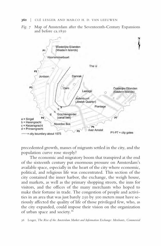
Fig. 7 Map of Amsterdam after the Seventeenth-Century Expansionsand before ca.1850

Not even in medieval Amsterdam, which had grown more orless organically, had economic activities and social groups ran-domly been scattered throughout the city, but at the end of thesixteenth century, a spatial division of functions and people wasdeliberately undertaken—certain parts of the expanded city zonedfor large-scale industry and harbor-related enterprises and otherparts for homes. The elite tended to prefer the spacious and tree-lined canals (Figure 7). The lower social classes, including crafts-men, found accommodation in the side and back streets.37
Because of the growing demand for residential and businessspace, Amsterdam underwent two more expansions in the seven-teenth century, resulting in the famous belt of canals around thecity that gave Amsterdam its shape until late in the nineteenth cen-tury. The spatial arrangement of economic activities and socialgroups took effect on a much larger scale this time. The success ofspacious canals as living areas for the elite served as a starting pointfor establishing residential areas. A broad belt of canals was placedaround the old city expressly to create a residential quarter for theelite. This purpose is evident in the anomalous urban developmentof the area, especially the generous sizes of the properties on theHerengracht and Keizersgracht, the breadth of the canals, and thepurchasing conditions that forbade, among other things, clutteringthe inner spaces with alleys and buildings. In 1615, the city author-ities decreed “that the properties on the Herengracht should bebuilt with nice residences and houses for people of private meansand other wealthy people.” In 1618, they banned harmful anddangerous businesses from this canal and the other canals in thebelt. The intent was clearly to ensure a peaceful and attractive liv-ing environment for Amsterdam’s leading citizens.38
RESIDENTIAL SEGREGATION | 361
Expansion and Change in the Spatial Economy of the Low Countries, c.1550–1630 (Aldershot, 2006),243–249.37 Boudewijn Bakker, “De zichtbare stad 1578–1813,” in Willem Frijhoff and MaartenPrak (eds.), Geschiedenis van Amsterdam: Centrum van de wereld 1578–1650 (Amsterdam, 2004),17–101, 28–30, 36–37; Jaap Evert Abrahamse, De grote uitleg van Amsterdam: Stadsontwikkelingin de zeventiende eeuw (Bussum, 2010), 246–248; S. A. C. Dudok van Heel, “Regent Familiesand Urban Development in Amsterdam,” in Peter van Kessel and Elisja Schulte (eds.),Rome—Amsterdam: Two growing Cities in Seventeenth-Century Europe (Amsterdam, 1997) 124–145.38 The most important and recent work about the expansions in seventeenth-century Am-sterdam is Abrahamse, De grote uitleg van Amsterdam. For more on the third expansion, seeLenna Jansen, “De derde vergroting van Amsterdam,” Jaarboek Amstelodamum, LII (1960), 42–89; Ed Taverne, In’t land van belofte: in de nieue stadt: Ideaal en werkelijkheid van de stadsuitleg in de

The elite, however, were not the only ones to beneªt fromthe canal belt. The pattern of wide canals and narrow connectingstreets naturally created differentiation among the residents. Thewell-to-do lived on the canals, and the middle groups—comprisedof shopkeepers, craftsmen, the occasional barber-surgeon, andanyone else of private means who could not afford a house on oneof the primary canals—lived on the cross-streets. The poor, how-ever, were not likely to be found in the canal belt. The fact that aseparate neighborhood was created for the upper echelon impliesthat other neighborhoods would devolve to the rest of the popula-tion. Both the established population and the immigrants includedtradesmen, sailors, and semischooled or unschooled workers.They took up residence on the edges of the city—in the Jordaan,on man-made islands in the west and east of the city, and else-where on the periphery—where residential crowding and loud,malodorous industry were the norm.39
Nonetheless, the contrast between the canal belt and the pe-riphery should not blind us to the further patterns of segregationwithin the Jordaan, for instance. A number of canals in the middleof this neighborhood (Egelantiersgracht, Bloemgracht, Rozen-gracht, and Lauriergracht) were intended for the middle class. Thefamous Blaeu cartographers lived in this area, as did the mayor’sson and, later, Mayor Joan Huydecoper himself. This middle areaof the Jordaan, and especially Nieuwe Leliestraat, served an im-portant trafªc function, connecting the polders to the west of thecity with the old city center. The remaining longitudinal streetsbetween the town ramparts and the Prinsengracht, which hadpractically no passing trafªc, housed the lower social classes. Thecross-streets (north–south), the most important trafªc connectionswithin the Jordaan itself, housed the lower-middle-class shop-keepers. From the outset, the poorest segment of the Jordaan’spopulation inhabited the walled-in houses in the inner courtyards.
362 | CLÉ LESGER AND MARCO H. D. VAN LEEUWEN
Republiek 1580–1680 (Maarssen, 1978), 165–168 (for the ban of 1618). Abrahamse, De groteuitleg van Amsterdam, 62.39 For living conditions, see Willem F. H. Oldewelt (ed.), Kohier van de Personeele Quotisatiete Amsterdam over het jaar 1742 (Amsterdam, 1945). The narrow Kerkstraat is a possible excep-tion to the exclusion of the poor from the canal belt. This street contained the stables and car-riage houses belonging to the expensive properties on the canal, but the few beggars in thisarea lived on the Kerkstraat too.

The prevalence of the poor increased with distance from the mid-dle section of the Jordaan.40
Hence, in the Jordaan, as in other urban areas, rent could varygreatly over short distances. In consequence, poor and wealthierresidents lived in each other’s immediate vicinity, without inten-sive mixing on individual streets. Thus, like Alkmaar and Delft,Amsterdam experienced “around the corner” segregation.
In the long term, the old inner city lost status to the newly es-tablished canal belt. However, the elite did not move fromWarmoesstraat to the canals in one fell swoop. The hundredth-penny tax imposed on properties in 1631 reveals that a consider-able portion of the wealthiest Amsterdammers still lived in the oldcity. Another tax record, the Personeele Quotisatie of 1742, re-veals that more than a century later, the canal belt housed eighty-four of the one-hundred highest-taxed individuals, primarily onthe Herengracht. The relative decrease in status of the inner city isunmistakeable, but it does not imply that the center fell victim toimpoverishment and homogenization. Many of the most prosper-ous Amsterdammers still lived there, amid a largely persisting pat-tern of segregation. The socioeconomic positions of those wholived along the primary canals and streets and those dwelling incross-streets, alleys, and lanes remained conspicuously distinct.41
Yet, the separation of social groups was less pronounced inthe old inner city than in the newer neighborhoods. The old cityhoused a larger segment of the social pyramid. Everyone from theextremely wealthy to the extremely poor lived there. In the newareas, only one neighborhood had a comparable distribution of so-cial groups—the Jodenbuurt (the Jewish Quarter). Amsterdam hadno laws requiring Jews to live in a speciªc part of the city, but al-most all of Amsterdam’s Jews lived near their synagogues in the
RESIDENTIAL SEGREGATION | 363
40 Isabella H. van Eeghen, “Een burgemeestershuis in de Jordaan,” Maandblad Amstelo-damum, LXII (1975),127–130; for Huydecoper and family, Luuc Kooijmans, Vriendschap en dekunst van het overleven in de zeventiende en achttiende eeuw (Amsterdam,1997). For the spatialstructure of the Jordaan, see H.Tj. Dijkhuis, “De Jordaan: De ontwikkeling van een volkswijkin een grote stad,” Economisch-Historisch Jaarboek, XXI (1940), 1–90; for location patterns inthe retailing industry, Lesger, “Patterns of Retail Location and Urban Form in Amsterdam inthe Eighteenth Century,” Urban History, XXXVIII (2011), 24–47.41 Johannes G. Frederiks and Pieter J. Frederiks, Kohier van den tweehonderdsten penning voorAmsterdam en onderhoorige plaatsen over 1631 (Amsterdam, 1890); Lesger, “Migranten in Amster-dam in de achttiende eeuw: Residentiële spreiding en positie in de samenleving,” JaarboekAmstelodamum, LXXXIX (1997), 43–68, Table 2 (47).

eastern part of the city. This relatively small area had merchantsand bankers as well as penniless street hawkers and beggars. Thelaws of the real-estate market and the spatial structure of Amster-dam exerted their inºuence just as much in the Jodenbuurt, result-ing in meso-segregation—spatial segregation at the street level.Prosperous Jews lived mostly on the Nieuwe Herengracht; middlegroups lived primarily on streets and less attractive canals; and thepoor lived in alleys and lanes.42
Models for Explaining Ethnic SegregationThe Spatial-Assimilation Model. The complicating inºu-
ence of ethnic factors on wealth/income stratiªcation (in our case,measured via rental values) is apparent in the work of Sjoberg andVance, as well as in the explanatory models that geographers oftenuse to explain residential segregation. The ªrst such model is theChicago-school, or spatial-assimilation model. It concedes that,upon entering their new country, migrants usually have lessmoney and status than native-born residents, and they are usuallyless ºuent in the language of the new country. Even when goodhousing is available to them, they often cannot afford it or com-municate well enough to secure it, relegating them to less desir-able neighborhoods. The model also maintains, however, that mi-grants can overcome their initial disadvantages and move to betterand mixed neighborhoods. Like Vance’s model, it eventually al-lows for the rich and poor to be distributed spatially according tothe real-estate market. Yet, given the tenacity of the spatial con-centration of Jews, it does not seem wholly adequate to the situa-tion in early modern Amsterdam.43
364 | CLÉ LESGER AND MARCO H. D. VAN LEEUWEN
42 Exceptions to this predominant pattern of living arrangements included a few largehouses on St. Antoniesbreestraat (the house of Isaac de Pinto) and on Jodenbreestraat, whereprimarily (upper) middle-class residents lived.43 Charles, “Dynamics of Racial Residential Segregation,” 170. See also Bolt, Kempen,and Ham, “Minority Ethnic Groups”; Milton M. Gordon, Assimilation in American Life: TheRole of Race, Religion, and National Origins (New York, 1964); Massey and Denton, AmericanApartheid; Laan Bouma-Doff, “Involuntary Isolation”; Stanley Lieberson, “The Impact ofResidential Segregation on Ethnic Assimilation,” Social Forces, XL (1961), 52–57; John R. Lo-gan and Richard D. Alba, “Locational Returns on Human Capital: Minority Access to Subur-ban Community Resources,” Demography, XXX (1993), 243–267; Massey, “EthnicResidential Segregation: A Theoretical Synthesis and Empirical Review,” Sociology and SocialResearch, LXIX (1985), 315–350. For Jewish assimilation and segregation, see, for example,Jacqueline Vijgen, “Joden In Amsterdam: Assimilatie en segregatie van een ethnischeminderheid 1600–1933,” unpub. M.A. thesis (Univ. of Amsterdam, 1983); Hetty Berg (ed.),De Gelykstaat der Joden: Inburgering van een minderheid (Amsterdam, 1996); van Leeuwen, TheLogic of Charity: Amsterdam, 1800–1850 (Houndmills, 2000), 38–39, 44–45, 111–161.

The Place-Stratiªcation Model. Contrary to the spatial-assimilation model, the place-stratiªcation, or discrimination,model, denies that segregated ethnic groups can ever achieve full-scale spatial assimilation, regardless of any improvement in theirobjective characteristics. Not even high incomes can guaranteethem access to better neighborhoods or spare them from the prej-udice of real-estate agents et al. Although Amsterdam was notcalled the Jerusalem of the North without reason, the obvious dis-dain directed toward Jews by Amsterdammers gives this modelsome credence, despite the conspicuous presence of afºuent Jew-ish merchants and the absence of pogroms and Jewish ghettos.More pertinent, however, was the power that Amsterdam’s civicauthorities had conferred on the Jewish elites to govern the city’sAshkenazi and Sephardic Jews. This self-rule was probably moreresponsible for keeping the Jewish communities together—spa-tially and socially—than discrimination in the real-estate marketwas. The ban on marriages between Jews and non-Jews, the lan-guage barrier, and, in the case of poor Ashkenazi Jews, differencesin clothing compared to non-Jews, were also important.44
The In-Group Model. The in-group, or ethnic-prefer-ences, model, states that “all groups have a ‘strong desire’ forneighborhoods with substantial numbers of co-ethnics that reºecta simple, natural ethnocentricism rather than outgroup hostility oran effort to preserve relative status advantage.” Members of anethnic group, such as the Amsterdam Jews, tend to live in the sameneighborhoods not only because of a sense of familiarity but alsobecause of the existence of a local ethnic infrastructure of shopsand, in our case, synagogues.45
In addition to segregation at the neighborhood level (macro)and the street level (meso), Amsterdam was segregated throughºoors of houses (micro). It is hardly surprising that Amsterdam
RESIDENTIAL SEGREGATION | 365
44 Charles, “Dynamics of Racial Residential Segregation,” 170. See also Bolt, Kempen,and Ham, “Minority Ethnic Groups”; Logan and Alba, “Locational Returns”; Laan Bouma-Doff, “Involuntary Isolation.”45 Charles, “Dynamics of Racial Residential Segregation,” 182. See also Bolt, Kempen,and Ham, “Minority Ethnic Groups”; Boal, “Ethnic Residential Segregation,” 41–79; Wil-liam A. V. Clark, “Residential Preferences and Neighborhood Racial Segregation: A Test ofthe Schelling Segregation Model,” Demography, XXVIII (1991), 1–19, 451; OrlandoPatterson, The Ordeal of Integration: Progress and Resentment in America’s Racial Crisis (Washing-ton, D.C., 1997); Stephan Thernstrom and Abigail Thernstrom, America in Black and White:One Nation, Indivisible (New York, 1997); Laan Bouma-Doff, “Involuntary Isolation.”

(and cities like it), with a dense population and an abundance ofpoor people, would have houses divided into multiple apartmentsand rented separately. In 1665, van Domselaer reported thataround the middle of the seventeenth century, certain streets hadapartments built exclusively for the petty bourgeoisie in the man-ner of independent homes. That is not to say, however, thatmicro-segregation was nonexistent elsewhere in the city. On thecontrary, the rooms, cellars and outbuildings of existing houseswere frequently rented separately, particularly in lower-classneighborhoods. Van Domselaer wrote that in the crowded neigh-borhood east of the old inner city, where many craftsmen and sail-ors lived, four families sometimes occupied a single house. Theadjustment of the verponding in 1733 reveals that housing of thistype was not uncommon and that renting on the street level wasgenerally much more expensive than renting basements, outbuild-ings, and upstairs rooms. Further research is needed, but in view ofthe differences in rental value, the economic position and socialstatus of inhabitants in the same house could vary considerably, al-lowing for segregation at close quarters.46
Like Alkmaar and Delft, Amsterdam also lacked a compactelite quarter. The canal belt stretched around the medieval city, asit does now. Unlike the elite class in Alkmaar and Delft, however,Amsterdam’s privileged class was actually large enough to driveconstruction of a compact elite quarter. Why it never happened isnot easy to ascertain. No surviving documents indicate that such aliving area was ever under consideration. The city simply contin-ued to expand as it always had expanded—creating more circlesaround the oldest core of Amsterdam on the banks of the AmstelRiver as necessary. Well-to-do Amsterdammers’ preferences forspacious and tree-lined canals must have also played a role, alongwith the fact that Amsterdam lacked a clear focal point. Unlikemany European capitals, Amsterdam always lacked a princelycourt to attract nobility, which would have been a likely focalpoint for a compact luxury quarter.
Because the Amsterdam elite largely acquired their wealththrough economic activities rather than through land ownershipor the privileges of an aristocracy, the center of town—withits market, exchange, weigh-house, auction houses, and other
366 | CLÉ LESGER AND MARCO H. D. VAN LEEUWEN
46 Tobias van Domselaer, Beschryvinge van Amsterdam, haar eerste oorspronk . . . tot dezentegenwoordige jare 1665, is voorgevallen (Amsterdam, 1665), III, 254; Abrahamse, De grote uitlegvan Amsterdam, 106–108.
facilities—remained the locus of their daily routine. A shell of lux-ury buildings around the city center made sense in this context be-cause of its proximity to the center and its air of quiet distinction.Given Amsterdam’s persisting infrastructure, its elite was able liter-ally to push the lower social classes and the noisy, smelly industrialactivities out of the area that was to become the canal belt tothe edges of urban society and thus largely out of contact. Since theHerengracht and Keizersgracht had no direct connection withthe harbor, these luxury areas could enjoy peace and calm both onland and on the water.47
The prevailing image of residential segregation derives from re-search on the nineteenth and twentieth century, since most of thesurviving sources pertain to these times. Yet, the lack of directknowledge about early modern sociospatial conditions leads to atruncated perspective. Unfortunately, the scarcity of data from thisperiod and the problems associated with mapping it are daunting.Moreover, little is known about people’s subjective preferencesand socioeconomic characteristics at the time, as well as about theinºuence of governments, ªnanciers, and real-estate agents onpatterns of residential segregation. This study beneªts from therelative availability of rental prices for early modern cities in Hol-land. Although the limitations of these records are undeniable, re-quiring the collection of considerable supplementary source mate-rial, we now draw conclusions and make provisional statementsabout residential patterns over the long term.
Detailed reconstructions for Alkmaar and Delft, two smallercities in Holland, make clear that the level of detail greatlyinºuences the results. Research in Alkmaar suggests that in addi-tion to macro-segregation, “around the corner” segregation(meso) was typical from the seventeenth to the middle of the nine-teenth century. This continuity is compatible with the fact thatresidential patterns adjusted to changing dynamics in an urban en-vironment. In the case of Alkmaar, economic decline led to a re-duction of high-value (commercial) buildings in the eastern part ofthe city, but due to political and governmental continuity, existingpatterns were retained in the western part of the city, which con-tained the town hall and other important public buildings.
In explaining these residential patterns, Sjoberg’s static model
RESIDENTIAL SEGREGATION | 367
47 Abrahamse, De grote uitleg van Amsterdam, 71–77, 265–267.
is of limited utility. The degree of mixing was much greater thanSjoberg suggests. Moreover, the town center was certainly not theexclusive domain of the elite, and economic activities had muchmore prestige than Sjoberg’s model can accommodate. Vance’smodel, with its watershed between the precapitalist and capitalistcity, allows for too much social change, though a core element ofhis theory—the value of land and the operation of the real-estatemarket—ªnds support in the Dutch data. Residential patterns arebest explained by differences in the price of land based on loca-tion. In short, the well-to-do and middle classes had the means torealize their location preferences, and the less fortunate had to besatisªed with less attractive options—side and back streets, and thealleys and lanes that led to them—“around the corner” from themore desirable spots. The precise location of the attractive and lessattractive locations depended on local context and the existing citystructure. In low-lying Dutch towns, the well-to-do gravitated to-ward broad canals; elsewhere in Europe, differences in altitude orthe site of a princely palace were important considerations.
The example of Amsterdam lends more insight into the effectof demographic growth and city expansion on residential patterns.Amsterdam began a period of rapid growth at the end of the six-teenth century; by the middle of the seventeenth century, it hadbecome one of Europe’s largest cities. Even though detailed infor-mation is not yet available, expansion in Amsterdam (much likelarge-scale reconstruction after ªres and other disasters elsewhere)greatly inºuenced residential patterns. The city government delib-erately strove for a division of social groups and economic func-tions. Although the exodus of elites from the increasingly con-gested city center to new districts was decidedly less drastic thanVance’s model assumes, a sizable fraction of the social and eco-nomic elite relocated to an exclusive living environment just out-side the old city. The commercial facilities of the center, however,remained easily accessible to Amsterdam’s merchant elite. The(lower) middle class and craftsmen, along with their economic ac-tivities, were relegated to new neighborhoods on the outskirts ofthe city.48
Compared to the old medieval city, the new neighborhoods
368 | CLÉ LESGER AND MARCO H. D. VAN LEEUWEN
48 Nor did sixteenth-century Amsterdam witness a transition from a guild-dominated soci-ety to one dominated by merchants, as Vance claims. Merchants continued to be incorporatedin the oligopoly of ruling families. Guilds never exercised signiªcant, direct political authority,
were considerably more socially homogeneous. The wealthiestand poorest people no longer shared the same living space. Buteven in the new neighborhoods, location and related rental pricesresulted in differentiation at street level and even at the level ofhouses and ºoors on a particular street. Hence, the new neighbor-hoods were mixed, though they did not all house the same seg-ments of the social pyramid.
The spatial patterns identiªed herein exhibit considerable du-rability; location preferences tend to solidify. These preferencesare embodied in long-lasting constructions like houses and publicbuildings. For this reason, municipal and sociospatial develop-ments coalesce into a morphological structure with a great degreeof historical continuity and path dependency. What exists nowgreatly depends on what preceded it. Even in more recent, large-scale changes to the urban landscape, old structures continue toexert their inºuence.
RESIDENTIAL SEGREGATION | 369
though they controlled the organization of production and secured the welfare of their mem-bers. See van Leeuwen, “Guilds and Middle-Class Welfare 1550–1800: Provisions for Burial,Sickness, Old Age, and Widowhood,” Economic History Review (forthcoming).