usk management catchment - natural resources wales · how we can make these summary documents as...
TRANSCRIPT

Usk Management Catchment Summary Date

Page 2 of 18 www.naturalresourceswales.gov.uk
Contents
1. Background to the management catchment summary .................................................... 3
2. The Usk Management Catchment ................................................................................... 4
3. Current Status of the water environment ......................................................................... 7
4. The main challenges ........................................................................................................ 9
5. Objectives and measures .............................................................................................. 12
6. What next? ..................................................................................................................... 16
7. Water Watch Wales ....................................................................................................... 16

Page 3 of 18 www.naturalresourceswales.gov.uk
1. Background to the management catchment summary This management catchment summary supports the current consultation on the updated river basin management plans. Along with detailed information on the Water Watch Wales website, this summary will help to inform and support delivery of local environmental improvements.
Natural Resources Wales has adopted the ecosystem approach. This means being more joined up in how we manage the environment and its natural resources to deliver economic, social and environmental benefits for a healthier, more resilient Wales. It means considering and regulating the environment as a whole, rather than dealing with individual aspects separately; weighing up and setting priorities for the many competing demands on our natural resources in a more integrated way. Partnership working is essential to achieve our ambition. By working together in this management catchment we will:
understand the issues in catchments and how they interact
understand how the issues are affecting the current local benefits and future uses of water
involve local people, communities, organisations and businesses in making decisions by sharing evidence
identify which issues to tackle as a priority.
The Water Framework Directive provides a major overarching framework for river basin management. The Floods Directive sets out a strategic approach to flood risk management planning. A flood risk management plan has been produced for consultation in parallel to the river basin management plan and can also be found on our website. The flood risk management plan details how we propose to manage flood risk across the river basin district by prioritising those communities that are most at risk of flooding and detailing the measures we intend to take to manage their risk.
The flood risk management plan and the river basin management plan will shape important decisions, direct considerable investment and action, and deliver significant benefits to society and the environment.
As part of the consultation we are asking you for your input on priority opportunities and how we can make these summary documents as useful and relevant to the management catchment as possible. Within the river basin management plan consultation documents are a number of consultation questions; these will provide a useful starting point to gather your ideas in order to improve not only this document but partnership options to ensure that we work together to provide the best environmental options. We encourage you to look at the river basin management plans and respond to the consultation questions which you can find on our website.

Page 4 of 18 www.naturalresourceswales.gov.uk
2. The Usk Management Catchment Figure 1. The Usk Management Catchment
The River Usk rises on the northern slopes of the Black Mountain and flows in a long narrow catchment of great scenic beauty for approximately 125km south easterly through the towns of Brecon, Crickhowell, Abergavenny and Usk, before discharging to the Usk estuary at Newbridge and then to the Severn estuary at Newport. The catchment includes the Gwent Levels to the south; a large area of reclaimed coastal grasslands of historical and nature conservation importance. Tourism is important to the local economy, with the Brecon Beacons National Park and the Monmouthshire and Brecon Canal attracting visitors in search of outdoor recreation. The Usk management catchment is rich in wildlife, including three species of lamprey and bullhead and a variety of habitats. This high ecological value is recognised through national and international designations.
Land is predominantly used for agriculture, with sheep farming in the northern and western uplands, and beef, dairy, mixed and arable farming in the lowlands of the south and east. As a result, pollution from rural sources is a major threat to the quality of wildlife and plants living in the water environment. There is some limited industry in the major towns, and Newport has a commercial port. Pollution from sewage and contaminated run-off is a pressure in the urban areas.
The headwaters and some of its tributaries are modified by dams to create the Usk, Crai, Talybont and Grwyne Fawr reservoirs. At Brecon some of the river's flow is diverted to feed the Monmouthshire and Brecon Canal and water from the lower River Usk is pumped to Llandegfedd water storage reservoir. On the Gwent Levels flows are regulated by the Caldicot and Wentlooge Internal Drainage Board. Water is taken from rivers and
Page 5 of 18 www.naturalresourceswales.gov.uk
underground sources to use in agriculture, industry, hydropower and fish farms. It is necessary to continue work with Dwr Cymru Welsh Water and others to minimise the impact on the natural environment caused by the physical modifications and abstraction, while securing this valuable resource and maintaining flow levels.
The Usk is a high quality river for fisheries, supporting salmon, an internationally important population of twaite shad, lamprey, bullhead and brown trout. The river has a largely natural flow, however barriers at Trostrey (a gauging weir), Llanfoist and Crickhowell (bridge footings) and Brecon (a weir supporting the canal abstraction) all restrict the upstream distribution of shad and sea lamprey. Barriers in some tributaries and the reservoir dams also restrict fish distribution and prevent access to suitable habitat. Natural Resources Wales, local authorities, the Canal and Rivers Trust and others will need to take action as part of a prioritised programme.
Priorities for this catchment to achieve healthy waters are to improve the special habitats by reducing the impact of rural pollution; reducing the impact of physical modifications and abstraction while securing water supplies.
The Usk management catchment summary does not include information on neighbouring coastal or estuarine waters as these are included within the Severn River Basin Management Plan.
During December 2013 an Usk management catchment workshop was held at the Newport Wetlands visitor centre. During this event the benefits of the catchment were captured. These included;
Biodiversity – of the river and wetlands. Importance shown by designations such as the riverine Special Area of Conservation, Gwent levels SSSI, Biodiversity Action Plan species e.g. Otter and Shad.
Food production.
Recreation & Tourism – canoeing, fisheries, walking, boating, camping, cycling, Brecon Beacons National Park.
Renewable energy – hydropower.
Water as a resource for drinking, irrigation and navigation.
Woodlands - both as a resource and for their own ecological importance.
Natural Resources Wales continues to work in partnership with a range of partners and sectors in innovative ways so that we can achieve even more together. A flavour of some of the projects within this management catchment is provided in Table 1. Table 1. Examples of projects in the management catchment.
Project Name Project Description Partners
Monmouthshire Olway & Trothy Project
Riparian restoration project including tree work, pleaching of woody material into the channel to improve habitat for fish and invertebrates plus single bank fencing.
Wye & Usk Foundation

Page 6 of 18 www.naturalresourceswales.gov.uk
Project Name Project Description Partners
Living Levels A project in development on the Gwent levels which aims to improve landscape connectivity, land management, restore wetland habitats & develop recreation opportunities with benefits for local communities, WFD and biodiversity.
RSPB, Gwent Wildlife Trust, Internal Drainage Board, local landowners, community
Case study – River Olway Project The Olway was identified as having a moderate classification under the Water Framework Directive because of low densities of fish and Phosphate. Along this stretch cattle access to the river contributed to poaching and increased sedimentation. By providing controlled stock access to keep the cattle to a defined area and reducing time spent in the river the project aimed to fence along identified sections, add crossing points, drinking bays and swing gates. The project also included fencing, coppicing, installing bank revetments and planting willows. Since the instalment of the habitat schemes the river bank has had an opportunity to naturally regenerate reducing the likelihood of bank erosion during high flows and helping reduce sedimentation which will keep more of the river’s gravel beds free of sediment and available to spawning fish and therefore increasing the chances for spawning success.

Page 7 of 18 www.naturalresourceswales.gov.uk
2.1 Key facts We use the term water bodies to help understand and manage the water environment. A water body is part, or the whole, of a river, lake, ground water or coastal water. The number and type of water bodies in the management catchment is shown in the table below.
Table 2. Number and type of water bodies.
Number of water bodies Natural Artificial Heavily Modified Total
River* 36 5 (2 canals) 5 46
Lake
1 11 12
Coastal
0
Estuarine
1 1
Groundwater 10
10
Total 46 6 17 69
*River water bodies includes canals and surface water transfers
There are areas in the catchment where the water environment is recognised as being of particular importance, including rare wildlife habitats, bathing waters or areas around drinking water sources. These areas are known collectively as protected areas and are detailed in the table below.
Table 3. Number and type of protected areas.
Protected Area Number
Bathing Waters 0
Drinking Water Protected Areas 36
Natura 2000 and Ramsar sites 11
Nitrate Vulnerable Zones 3161ha
Shellfish Waters 0
Urban Waste Water Treatment Directive - Sensitive areas
0
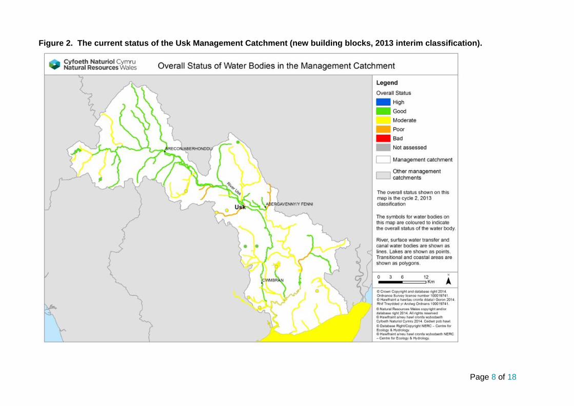
3. Current Status of the water environment We assess the condition of water bodies through monitoring which produces an annual classification. The current status for each water body is shown in figure 2. Note, since 2009, we have updated some of the systems we use to classify water bodies, including changes to some standards and water body boundaries.
Page 8 of 18
Figure 2. The current status of the Usk Management Catchment (new building blocks, 2013 interim classification).

Page 9 of 18 www.naturalresourceswales.gov.uk
4. The main challenges We have carried out a series of investigations to confirm failures and the reasons driving them. This has included 14 river walks to assess the situation on the ground in more detail. Figure 3. Reasons for not achieving good status in the Usk Management
In the upper Usk catchment above Brecon there are some modifications for reservoirs but no evidence of marked ecological impacts. In the past there have been some pollutions (Tarrell), but by and large there is little evidence of impact. Between Brecon and Abergavenny there are pressures from:
Abstraction (Crawnon – Mon Brec canal off take)
Habitat that could be improved
Barriers to migration (Mon-Brec canal bridges)
Urban Misconnections
Below Abergavenny issues are largely around rural land management – so diffuse pollution, but also some misconnections in the Nedern. Some examples of actions that are already under way include:
Urban / Misconnections; fixing and awareness raising; Partners Dwr Cymru Welsh Water & Local Authorities; Nedern Brook, Monks Ditch, Gavenny.
Natural Resources Wales agricultural site visits. Reens and Olway. Catchment Initiative also ran on the Olway in the 1st cycle, soil sampling, analysis and advice for farmers. Working with various partners; LEAF (Linking Environment and Farming), Young Farmers Club, Dairy Development Centre, FWAG (Farming and Wildlife Advisory Group), The Machinery Ring (PMR).
The Wye and Usk Foundation have carried out barrier removal and habitat improvement in multiple water bodies.
Also Dwr Cymru Welsh Water are looking at where there assets, both water resources and water quality, maybe impacting.

Page 10 of 18 www.naturalresourceswales.gov.uk
4.1 Workshop feedback on challenges We need to work together to ensure the overall aims of the Water Framework Directive are met and to agree on the priority issues and solutions. The following is a list of some of the challenges that were raised as part of the recent workshop (it is not a full list). All of the comments received will be taken into account and the following is just a flavour of these comments:
Barriers to fish migration
Diffuse pollution from agriculture and rural land management in general.
Diffuse pollution from urban areas, misconnections, development pressure.
Flooding
INNS (Invasive Non Native Species) e.g. Mink, Himalayan Balsam, Giant Hogweed, Japanese Knotweed, Signal Crayfish
Lack of habitat connectivity
Lack of education & advice on a range of issues.
Potential for conflict between various users / beneficiaries
Water levels – ensuring adequate flow and active river processes. Pressure from abstraction

Page 11 of 18 www.naturalresourceswales.gov.uk
Case study – River Usk Giant Hogweed Project Giant Hogweed is an invasive plant and is extensively distributed on the lower River Usk which is a Site of Special Scientific Interest (SSSI) and part of the River Usk Special Area of Conservation (SAC). The plant is mainly found from the Crickhowell area to the tidal limit at Newbridge-on-Usk. It has a damaging effect on the native habitat, suppressing the growth of native plants and leaving banks bare of vegetation and susceptible to erosion. It reduces the recreational value of the land and stops walkers and fishermen from accessing some areas. The sap from the plant can cause severe blisters, which are sensitive to sunlight, prompting public health concerns. Partners include Brecon Beacons National Park Authority, Keep Wales Tidy, Monmouthshire County Council, The National Trust and the Wye and Usk Foundation. Officers from these organisations provide time to this project and a number of volunteers have also been trained up and provide valuable input to the control work. Control work (mainly involving herbicide treatment ) on the ground started in the Spring of 2006 with efforts centred on the Crickhowell and Abergavenny areas. The aim is to stop the seed production at the upper extent of the infestation and prevent the seeds entering the river and spreading the problem downstream. Five spray teams are working on the project from Environment Agency Wales (now Natural Resources Wales), Keep Wales Tidy, Monmouthshire County Council, Brecon Beacons National Park Authority , the National Trust and the Wye and Usk Foundation.. Extensive control work has continued in the growing season along the river between Crickhowell and Newbridge-on-Usk since 2006 and the 2014 work is underway. A number of Forum events have been organised periodically to update and involve local riparian owners and river users on the progress of the project. The project has been widely reported by BBC TV and radio and ITV in Wales.

Page 12 of 18 www.naturalresourceswales.gov.uk
5. Objectives and measures This section outlines what we are aiming to achieve and the proposed new measures that need to be put in place. We aim to develop a single integrated programme of measures by 2021 that meets Water Framework Directive objectives:
Prevent deterioration in status Water body status will not be allowed to deteriorate from the current reported status.
Achieve the objectives for protected areas Achieve the standards set by the relevant directive under which they were designated. For water dependent Natura 2000 sites we will aim to achieve conservation objectives, achieving good status by 2021 is a milestone towards this objective.
Aim to achieve good overall status for surface and ground waters Implement measures to achieve good overall status where they are technically feasible and not disproportionately costly.
5.1 Measures We have reviewed the reasons why water bodies are failing to achieve objectives and identified potential measures .Measures are divided into two groups. National measures apply to the whole of Wales, or the United Kingdom. In general these set the legislative, policy or strategic approach. Examples include a national ban on using a particular chemical or a national strategy for prioritising and funding the remediation of abandoned mines. Local measures are specific to the river basin district or a part of it. For example, the removal of invasive plants along a length of designated river or a local campaign targeting misconnections across an industrial estate. Many of the actions listed will also have multiple benefits. For example, sustainable urban drainage (SuDs) schemes help to reduce urban pollution, sewage pollution and changes to water levels.
A list of all national measures, both new and existing, and the local measures at the water body scale are detailed on Water Watch Wales. If you know about any others or want to suggest new measures, please tell us in your response to the consultation. The river basin management plan will become a statutory document hence the importance of ensuring that the correct measures are identified through this consultation.
The table below summarises the local measures for the management catchment, including those identified for protected areas. The high level categories describe the types of action required and broadly the options that are available, including voluntary and regulatory measures. At the local scale some of the options described might not be considered appropriate. There is overlap between some categories.
Table 4. Summary of local measures.
Measure Description No. of water
bodies
Address air pollution Emissions controls to reduce nitrogen and acidic depostion.
9
Complete first cycle investigation
All ongoing WFD investigations from first cycle programme.
12
Drainage and water level management
Investigate and implement changes to land drainage regimes and structures to restore water levels.
5
Improve fish passage and habitat Remove or modify barriers to fish passage
35

Page 13 of 18 www.naturalresourceswales.gov.uk
Measure Description No. of water
bodies
Improve flows and water levels
Reduce impacts of regulated flows and abstractions, restore more natural flow regimes, implement options to improve water levels, such as water efficiency and recycling measures, alternative sources and supplies.
33
Manage invasive non-native species
Eradication and/or management of invasive non-native species in line with current national invasive species Action Plans. Includes biosecurity good practice, such as "CHECK-CLEAN-DRY" and Be Plant Wise.
34
Mine water and contaminated land remediation
Coal and metal mine, and contaminated land remediation - including passive and active mine water treatment, capping of spoil, removal of wastes to landfill, and channel diversion
3
Mitigate impacts of flood and coastal defences
Reduce impacts of flood defence structures and operations - improve connectivity, habitat, and morphology by implementing options through capital and maintenance programmes, such as soft engineering, opening culverts, upgrading tidal flaps, changing dredging and vegetation management. Includes the national habitat creation programme to address coastal squeeze.
34
Mitigate impacts of water resource impoundments
Assess and implement options for improving fish passage and habitat.
7
New Investigation Includes investigations for all new failures, deterioration, and drinking water protected areas.
34
Reduce impacts of other physical modifications
Improve connectivity, habitat and morphology through soft engineering and restoration techniques.
5
Reduce pollution from other waste water discharges
Reduce pollution from other (non-sewage) point sources, both regulated and unregulated. Investigate and implement basic pollution prevention measures, including provision of up to date advice and guidance, such as correct handling and storage of chemicals and waste, management of trade effluent, and regulation.
9
Sustainable access and recreation management
Reduce the impacts of erosion, disturbance and damage from both water-based and terrestrial access, including tackling illegal off-roading.
32

Page 14 of 18 www.naturalresourceswales.gov.uk
Measure Description No. of water
bodies
Sustainable agricultural practices
Implement basic and additional measures such as correct management of slurry, silage, fuel oil, and agricultural chemicals; clean and dirty water separation; nutrient management planning; buffer strips and riparian fencing; cover crops and soil management. In N2k sites changes to grazing regimes may be required, includes scrub management. Within NVZs comply with storage and spreading regulations.
41
Sustainable woodland and forestry management
Restore the riparian zone, disconnect forest drains, monitor the effectiveness of the 5 principle risks associated with forestry and use forestry and woodland to reduce diffuse pollution.
32
Tackle misconnections and urban diffuse pollution
Investigate and solve misconnections to surface water drains (at residential and commercial properties) and implement sustainable drainage schemes (SuDS) to reduce diffuse pollution.
3
Waste management Includes appropriate management of spoil and sludge, illegal fly-tipping and litter.
34
5.2 Opportunities for partnerships There are several external funding opportunities, which could support projects that contribute towards Water Framework Directive outcomes. Each fund has its own priorities, budgetary allocation and application process. Types of funding for consideration include:
European funds – The EU provides funding from a broad range of programmes.– go to the Welsh European Funding Office website for more information.
Lottery funding – such as Heritage Lottery Fund, Postcode Lottery and BIG Lottery Fund which have a range of programmes from £5000 up to £millions.
Charities, trusts & foundations – there are many of these operating and they often have a specific focus – either geographically or topically and will support local charities and projects.
Businesses and sponsorship opportunities – including making the most of the Welsh carrier bag charge!
Public bodies – local authorities, Welsh Government, UK Government and NRW may have annual funding opportunities or one-off competitions for their priority areas.
Crowd funding – gathering support from a wide range and number of funders, often including individuals and usually using the internet to raise awareness for a specific project needing funds.
Trading – increasingly funders are looking to support organisations with longer term sustainability in mind so developing trading opportunities can be something to consider too.
Brecon Beacons Sustainable Development Fund - support for economic, environmental, community & cultural projects in BBNP which improve the quality of life for local communities.

Page 15 of 18 www.naturalresourceswales.gov.uk
Your local County Voluntary Council and Wales Council for Voluntary Action will have up to date information on opportunities such as these as well as a host of other support available.

Page 16 of 18 www.naturalresourceswales.gov.uk
6. What next? This summary is intended to be a snap shot of the management catchment and should enable you to be able to access further detail using Water Watch Wales. We welcome your views on how we can improve how we do this.
The summary supports the current consultation on the updated river basin management plans. We encourage you to look at the river basin management plans and respond to the consultation questions which you can find on our website.If you have any questions, please e-mail:
[email protected] / [email protected]
7. Water Watch Wales During the implementation phase of the first river basin management plan many of our partners and stakeholders requested access to data and information to assist them in helping to deliver local environmental improvements. It was quite clear early on that the first plan was difficult to navigate and access at a local scale. Consequently with both the support and input from the river basin district liaison panels a web based tool has been developed. This tool is called Water Watch Wales. This is an interactive spatial web-based tool that provides supporting information and data layers which can assist partners.
We are continuing to develop this tool and see it as a critical link between the more strategic river basin management plan and local delivery. It should enable the user to access information on:
classification data at the water body scale
reasons for not achieving good status
objectives
measures/actions, including protected area information
partnership projects
Data can be retrieved in a number of formats (spreadsheets and summary reports). A user guide together with frequently asked questions is included with the tool and can be accessed from a link on the home page.

Page 17 of 18 www.naturalresourceswales.gov.uk
Figure 4. Opening screen shot for Water Watch Wales

Published by: Natural Resources Wales Cambria House 29 Newport Road Cardiff CF24 0TP 0300 065 3000 (Mon-Fri, 8am - 6pm) [email protected] www.naturalresourceswales.gov.uk © Natural Resources Wales All rights reserved. This document may be reproduced with prior permission of Natural Resources Wales