using uav-based systems to monitor air pollution...
TRANSCRIPT

Research ArticleUsing UAV-Based Systems to Monitor Air Pollution inAreas with Poor Accessibility
Oscar Alvear12 Nicola Roberto Zema3 Enrico Natalizio3 and Carlos T Calafate1
1Department of Computer Engineering Universitat Politecnica de Valencia Camino de Vera SN 46022 Valencia Spain2Department of Electrical Engineering Electronics and Telecommunications Universidad de Cuenca Av 12 de Abril SNCuenca Ecuador3Laboratoire Heudiasyc Sorbonne Universites Universite de Technologie de Compiegne CNRS 57 Avenue de LandshutCS 60319 60203 Compiegne Cedex France
Correspondence should be addressed to Oscar Alvear osaldoctorupves
Received 8 March 2017 Revised 16 June 2017 Accepted 9 July 2017 Published 7 August 2017
Academic Editor Guizhen Yu
Copyright copy 2017 Oscar Alvear et al This is an open access article distributed under the Creative Commons Attribution Licensewhich permits unrestricted use distribution and reproduction in any medium provided the original work is properly cited
Air pollution monitoring has recently become an issue of utmost importance in our society Despite the fact that crowdsensingapproaches could be an adequate solution for urban areas they cannot be implemented in rural environments Instead deploying afleet ofUAVs could be considered an acceptable alternative Embracing this approach this paper proposes the use ofUAVs equippedwith off-the-shelf sensors to perform air pollution monitoring tasks These UAVs are guided by our proposed Pollution-drivenUAV Control (PdUC) algorithm which is based on a chemotaxis metaheuristic and a local particle swarm optimization strategyTogether they allow automatically performing themonitoring of a specified area usingUAVs Experimental results show that whenusing PdUC an implicit priority guides the construction of pollutionmaps by focusing on areas where the pollutantsrsquo concentrationis higher This way accurate maps can be constructed in a faster manner when compared to other strategies The PdUC scheme iscompared against various standardmobility models through simulation showing that it achieves better performance In particularit is able to find the most polluted areas with more accuracy and provides a higher coverage within the time bounds defined by theUAV flight time
1 Introduction
Industrial growth has brought unforeseen technologicaladvances to our societies Unfortunately the price to payfor these advances has been an increase of air pollutionworldwide affecting both our health [1] and our lifestyle
Air quality monitoring is relevant not only for the peopleliving in urban areas but also because it directly affects cropsand different animalsinsects in rural environments [2]Thusdifferent solutions for measuring air quality should be soughtfor such environments
For abovementioned reasons environmental organiza-tions and governmental institutions are beginning to con-sider the monitoring of environmental pollutants as a pri-mary goal [3 4]
The majority of methods used insofar to keep track of airpollution inmajor cities rely on fixedmonitoring stations [5]
However the use of such dedicated architectures and hard-ware for pollutionmonitoring is outmatched in theory by theuse of crowdsensing [6] in areas with a high population den-sity Also new ground-vehicle-based mobile sensors whichwould theoretically be able to cover the same areas as the fixedsolutions while employing a reduced number of agents areemerging as a viable alternative (eg [7 8])
With respect to the widespread use of small pollutionmonitoring sensors embedded in mobile vehicles the possi-ble scenarios can be divided into two main classes
(i) Urban environments where it is possible to embed thesensors on a wide set of vehicles like bicycles [9 10] orcars [8]
(ii) Rural and industrial areas where vehicular traffic isscarce and limited to themain transportation arteries
HindawiJournal of Advanced TransportationVolume 2017 Article ID 8204353 14 pageshttpsdoiorg10115520178204353
2 Journal of Advanced Transportation
In the latter case crowdsensing often fails to provide enoughdata to obtain realistic measurements having the requiredgranularity
Regarding crowdsensing approaches projects like [11ndash13] relied on crowdsensing solutions to monitor pollution inurban areas However in rural and industrial zones availableoptions are quite more limited In the particular case of largerural or industrial areas a fleet of mobile vehicles could beefficiently used to cover the vast distances associated withthem Furthermore the use of autonomous sensor carriersis even more encouraged in this case due to the followingconsiderations
(i) The relative absence of civilian population to be takencare of during robotic operations
(ii) Stable and regulated positioning of obstacles(iii) Fewer constraints concerning UAV flight laws(iv) Safety and security concerns as some areas could be
dangerous to access for human operators
Since in these environments ground access is usuallyhindered and full of obstacles the most feasible way toimplement a fleet ofmobile pollutionmonitoring robots is viaUnmanned Aerial Vehicles (UAVs) [14]
Taking the aforementioned issues into considerationin this paper we propose the use of UAVs equipped withcommercial and off-the-shelf (COTS) devices and sensors toimplement a service of air pollutionmonitoring that leveragesthe use of bioinspired approaches as its main control strategyThese choices allow covering a specific area automatically andenable discovering the pollution distribution of a large area byprioritizing the most polluted zones inside it
We show that using our chemotaxis-based approach forUAV path control it is possible to achieve faster and moreaccurate estimations about the location of the most pollutedareas with respect to classical area-search approaches Ouranalysis also takes into account uncertainty-based consider-ations in the sensor sampling operations
This paper is organized as follows in Section 2 we referto some related works addressing UAV-based sensing UAVmobility models and UAV control protocols Sections 3 and4 present an overview of the UAV Configuration and theUAV Control System respectively In Section 5 we compareour algorithm against the Billiard and Spiral mobility modelsvia simulation Section 6 discusses the open issues in airpollution monitoring using UAVs Finally in Section 7 wepresent the conclusions of our work
2 Related Works
UAV-based solutions have experienced a very substantialincrease in the last decade especially in the past five yearsBack in 2004 NASA experts defined a wide set of civilapplications for UAVs [15] highlighting their potential inthe near future in areas such as commercial Earth Sciencesnational security and land management This preliminaryreport was ratified years later by authors such as Hugenholtzet al [16] who explained how the use of UAVs couldrevolutionize researchmethods in the fields of Earth Sciences
and remote sensing In [17] authors display the results ofa detailed study on different UAVs aspects showing theirapplicability in Agriculture and Forestry Disaster Monitor-ing Localization and Rescue Surveillance EnvironmentalMonitoring Vegetation Monitoring Photogrammetry andso on
If we focus specifically on research using quadrotormulticopters authors like Gupte et al [18] and Colomina andMolina [19] consider that given their high maneuverabilitycompactness and ease of use different applications for thesedevices are being found in areas including civil engineeringsearch and rescue emergency response national securitymilitary surveillance border patrol and surveillance as wellas in other areas such as Earth Sciences where they can beused to study climate change glacier dynamics and volcanicactivity or for atmospheric sampling among others
In our case we are more interested in atmosphericsampling to measure air pollution levels In this researcharea Anderson and Gaston [20] highlight the applicabilityof UAVs in the field of ecology emphasizing that the spatialand temporal resolutions of the data obtained by traditionalmethods often fail to adapt well to the requirements of localecology-oriented research Furthermore the use of UAVswhen flying at low altitudes and speeds offers new oppor-tunities in terms of ecological phenomena measurementsenabling the delivery of data with a finer spatial resolutionIn fact Zhang and Kovacs [21] explain how the images takenby small UAVs are becoming an alternative to high-resolutionsatellite images which are muchmore expensive to study thevariations in crop and soil conditions Specifically the use ofUAVs is considered a good alternative given its low cost ofoperation in environmental monitoring its high spatial andtemporal resolution and its high flexibility in the schedulingof image acquisitions A good example of this use can befound in the work of Bellvert et al [22] which shows howby using a multicopter equipped with a thermal camera itwas possible to obtain a very precise map of water levels in avineyard thereby achieving significant advances in the fieldof precision agriculture
Focusing on our topic despite the presence of severalworks related to air pollution monitoring using UnmannedAerial Systems (UAS) the majority of these involve mainlyswarmcreation or communication interaction between themAn example of such work is [23] where authors proposea mobility model for a group of nodes following ldquoVirtualTracksrdquo (highways valley etc) operating in a predefinedldquoSwitch Stationrdquo mode through which nodes can split ormerge with another group of nodes
Different works have been done related to mountingsensors in Unmanned Aerial Vehicles In this regard Ermanet al [24] use an UAV equipped with a sensor to createa Wireless Sensor Network thereby enabling each UAV toact as a sink or as a node but it does not try to optimizethe monitoring process Teh et al [25] propose a fixed-windaircraft carrying a sensor node that acts as a mobile gatewayshowing the communication between the UAV and differentstatic base stations which monitor the pollution In this casetheUAVonly recovers the data collected by the stations Khanet al [26] propose the design of a lightweight laser-based
Journal of Advanced Transportation 3
sensor for measuring trace gas species using UAVs mainlyanalyzing how the optical sensor captures the air pollutionsamples In [27] authors use a large-sized aircraft equippedwith ozone sensors to cover a wide area in an automatedmanner showing how the UAV improves the samplinggranularity
If we analyze works related to mobility models forUAS mobility control that could be used for air pollutionmonitoring tasks we can observe that basically no workfocuses on the coverage improvement for a certain area
For instance in [28] authors propose a mobility modelbased on the Enhanced Gauss-Markov model to eliminate orlimit the sudden stops and sharp turns that the random way-point mobility model typically creates Also in [29] authorspresent a semirandom circular movement (SRCM) basedmodel They analyze the coverage and network connectivityby comparing results against a random waypoint mobilitymodel
The authors of [30] compare their models against ran-domwaypoint-basedMarkov-based and Brownian-motion-based algorithms to cover a specific area analyzing theinfluence of the use of collision avoidance systems in thetime to achieve full area coverage The work in [31] comparesthe results of using the ldquoRandom Mobility Modelrdquo and theldquoDistributed Pheromone Repel Mobility Modelrdquo as directiondecision engines (next waypoint) in UAV environments Theauthors of [32] propose an algorithm to cover a specific areait selects a point in space along with the line perpendicularto its heading direction and then drives the UAV based ongeometric considerations
There are works focusing on using UAVs for specific tasksinvolving autonomousmovements An example is [33] whereauthors present a mobility model for the self-deployment ofan Aerial Ad Hoc Network in a disaster scenario in orderto create a flying and flexible communications infrastructurethat victims can use The mobility model proposed is basedmainly on the Jaccard dissimilarity metric to control thedeployment of the Unmanned Aerial Vehicles composing thenetwork A similar work is presented in [34] where insteadan in-network density analysis is used to select the physicalareas that need to be visited by a flying robot
Focusing solely on existing proposals addressingmobilitymodels we can find works such as [35] where authorspropose the Paparazzi Mobility Model (PPRZM) by definingfive types of movementsmdashStay-On Waypoint Eight Scanand Ovalmdashfollowing a defined state machine with differentprobabilities to change between states There are even studiesfollowing animal-based navigation patterns An exampleof such work is [36] where authors investigate the UAVplacement and navigation strategies with the end goal ofimproving network connectivity using local flocking rulesthat aerial living beings like birds and insects typically follow
The use of UAVs for air pollutionmonitoring in a specificarea using multirotor drones is however still not presentin scientific literature and this work can be seen as one ofthe first approaches in this direction Our contribution canbe divided into two parts (i) the design of a low-cost andopen-source UAV equipped with off-the-shelf sensors formonitoring tasks and (ii) the deployment of a protocol called
Sensor
RPi
RPi
Pixhawk
Serial
GrovePi
Analog
connector
Figure 1 Proposed UAV with air pollution sensors
PdUC (Pollution-drivenUAVControl) to automatically tracka target area by focusing on the most polluted regions
3 Overview of the Proposed Solution
To implement a solution for air pollution monitoring usingUAVs we have to consider like in any cyber-physical systemtwo main aspects (i) the hardware configuration and (ii) thecontrol process for controlling the system behavior
By following these guides our proposal can also be splitinto two parts (i) the physical configuration of the UAV andthe environmental sensors and (ii) the algorithm to controlthe UAV for automatically monitoring a specific area calledPollution-driven UAV Control (PdUC)
Even though we are not proposing in this paper animplementation using real UAVs we nevertheless present thespecification of the devised cyber-physical system
31 UAV Configuration We have designed a scheme todynamically drive the UAV by connecting the UAV controlmodule to a Raspberry Pi [37] and connecting the latter to theset of pollution sensors via an analog converter The schemeis shown in Figure 1
The UAV is driven using a Pixhawk Autopilot [38 39]which controls its physical functioning The Raspberry Pi ismounted over the UAV chassis and connected to the Pixhawkthrough a serial port The sensors are connected to theRaspberry Pi using a Grove Raspberry Hat (GrovePi) [40]which allows connecting different kinds of COTS sensorseasily Specifically we are using
(i) Pixhawk Autopilot a high-performance flight controlmodule suitable for several types of autonomous vehi-cles including multirotors helicopters cars boatsand fixed-wind aircrafts It is developed under theindependent open hardware Pixhawk project andit has two main components (i) an Autopilot hard-ware provides an industry standard autopilot mod-ule designed as a 168MHz Cortex M4F CPU with3D ACCGyroMAGBaro sensors microSD slot 5UARTs CAN I2C SPI ADC and so on (ii) anAutopilot software that includes a real-time Operat-ing System (RTOS) with a POXIS-style environmentto control the drone
4 Journal of Advanced Transportation
Air pollutionsensors
UAV sensors
UAV guidanceRPiPdUC
UAV controlUAVPixhawk
Figure 2 UAV control loop
(ii) Raspberry Pi one of the most popular single-board-computers (SBC) worldwide It is a low-cost andsmall-sized piece of hardware that allows exploringcomputing and that supports different OperatingSystems The most popular of them is Raspbianwhich is based on Debian although Ubuntu Mateor Windows 10 IoT Core can also be installedthereby allowing using several programming lan-guages Besides all Raspberry Pi versions benefitfrom several inputoutput ports operating at 5V thusbeing ideal for all sorts of IoT projects
(iii) GrovePi extension board that allows connecting sev-eral analogdigital grove ports to a Raspberry Pi in aneasyway It has several grove ports seven digital portsthree analog ports three I2C ports one serial port tothe GrovePi and a serial connector to the RaspberryPi
(iv) Grove Sensors sensors which use a grove-stand-ardized connector providing an easy connection todifferent boards like GrovePiThere are several COTSenvironmental sensors such as CO2 CO or alco-hol Specifically we mostly focus on ozone sensors(MQ131)
Figure 2 shows the closed-loop control scheme of ourproposal The Pixhawk Autopilot is responsible for the phys-ical control system of the UAV (lower level) while the Rasp-berry Pi is in charge of the Guidance system (higher level)determining the way forward
32 Autonomous Driving To deploy an algorithm for auto-matically monitoring a specific area we have analyzed first ofall different existing possibilities that could be useful to ourgoals
So to elaborate the proposed PdUC solution we haveused specific techniques such as the metaheuristics andoptimization algorithms described below
321 Chemotaxis Metaheuristic The use of rotary-wingUAVs equipped with chemical sensors and tasked to surveylarge areas could follow chemotactic [41] mobility pat-terns since their flight behavior could easily implement the
following two-phase algorithm first read a pollution concen-tration while hovering next follow a chemotactic step
Chemotaxis metaheuristics are based on bacteria move-ment In this model the microorganisms react to a chemicalstimulus by moving towards areas with a higher concentra-tion of some components (eg food) or moving away fromothers (eg poison) In our system we have considered thefollowing adaptation of the chemotaxis Let us consider an
agent 119894 moving on a Euclidean plane located at position 997888rarr119875 119894119895from an absolute reference axis and moving along time insequential steps 119895 For every chemotactic step a new position997888rarr119875 119894119895 is calculated based on the previous one defined by 119909119894119895minus1and 119910119894119895minus1 plus a step size 119889119894 applying a random direction 120579119894119895as specified in (1)
997888rarr119875 119894119895 = (119909119894119895minus1119910119894119895minus1) + (
119889119894 times cos (120579119894119895)119889119894 times sin (120579119894119895)) (1)
120579119894119895 = 120579119894119895minus1 + 120572119894119895 119901119894119895 ge 119901119894119895minus1minus120579119894119895minus1 + 120573119894119895 119901119894119895 lt 119901119894119895minus1 (2)
The direction 120579119894119895 as shown in (2) is calculated on the basisof the concentration value of a certain chemical componentsampled by an agent 119894 at step 119895 119901119894119895 With respect to the pre-viously sampled value 119901119894119895minus1 the following two types of move-ments are contemplatedRun andTumble In the former Runwhen the component concentration is increased with respectto the previous sample the movement continues to followthe same direction as before (120579119894119895minus1) plus a random angle 120572119894119895Regarding the latter Tumble when the concentration isdecreasing the movement takes a turn in the oppositedirection minus120579119894119895minus1 plus a random angle 120573119894119895 Notice that both 120572119894119895and 120573119894119895 are used to introduce variability and to maximize thegradient allowing reaching the most polluted areas faster
322 Particle Swarm Optimization Particle Swarm Opti-mization (PSO) is a technique introduced in [42] where asolution to a problem is represented as a particle 119901119894 movingin a D-dimensional space at a time 119905 each particle 119901119894
Journal of Advanced Transportation 5
Chemotaxisamp PSO movement
isMax amp ttl = maxTTL
StartUAV
No
Adaptativespiral movement
Yes
isMax
isComplete
Returnto home
Yes
Yes
No
No
Search
Explore
Chemotaxisdirection
No
Yes
Search Explore
PSO adjust
Read pollution
isMax
ttl = ttl +1
ttl = maxTTL
Move
ttl = 0
No
From startamp explore
To explore
Calculateround path
isRoundcompleted
Calculatenext step
Move amp read
To search
isMaxisCompleted
To returnto home
From search
YesYes
Yes
No
No
No
Figure 3 Overview of different states associated with the PdUC algorithm
maintains its position 119901119894119905 and its best performance position119901119894119887 To determine the next position 119901119894119905+1 PSO calculates thestochastic adjustment in the direction of the previous localbest position of 119894rsquos 119901119894119887 element along with the general bestposition of any element 119901119892
119887 as shown in
119901119894119905+1 = 120572 sdot 119901119894119905 + 119880 (0 120573) sdot (119901119894119887 minus 119901119894119905) + 119880 (0 120573)sdot (119901119892119887minus 119901119894119905) (3)
where 120572 and 120573 are constants to calibrate the algorithm and119880(0 120573) is a random number between [0 120573]4 Proposed Autonomic Solution
To consistently drive the UAVs so as to achieve the desiredarea coverage goals we have devised the following algorithmwhich incorporates a chemotactic approach
41 PdUC Algorithm In this context we have developedan algorithm called Pollution-driven UAV Control (PdUC)based on the chemotaxis metaheuristic concept to search anarea for the highest pollution concentration levels Once thispollution hotspot is found the flying drone covers the wholearea by following a spiral movement starting from the mostpolluted location
Our algorithm is composed of two phases (i) a searchphase in which the UAV searches for a globally maximum
pollution value and (ii) an exploration phase where the UAVexplores the surrounding area following a spiral movementuntil one of the following conditions occurs it covers thewhole area the allowed flight time ends or it finds anothermaximum value in which case it returns to the search phaseas shown Figure 3
The exploration phase is based mainly on two previouslydescribed techniques a chemotaxis metaheuristic and alocal particle swarm optimization algorithm As detailedin Algorithm 1 initially before the UAV starts its firstmovement it samples the pollution value and puts it in abuffer For each chemotactic step it starts to hover collectsanother sample and compares it with the previous one If thesampling variation is positive (increasing) the UAV followsa ldquoRunrdquo chemotaxis direction with a random 120572119894119895 of [minus30 30]degrees Otherwise if the sampling variation is decreasingthe UAV calculates the ldquoTumblerdquo chemotaxis direction in thereverse orientation with a random 120573119894119895 of [minus150 150] degreesalthough modified by the actual maximum value reached(119898119889119894) as shown in Figure 4 Equation (4) denotes the formulato calculate the new direction and 120574 specifies the weight ofthe119898119889119894 which must be between 0 and 1
To determine when PdUC has found a maximum localvalue we use a TTL (time-to-live) counter When PdUCfinds a maximum value the TTL is reset and increasinguntil a new maximum pollution value is found or until themaximumTTL value is reached In this case PdUC reverts to
6 Journal of Advanced Transportation
(1) while isSearching do(2) 1199011199011199001198971198971199061199051198941199001198992 larr 119862119906119903119903119890119899119905119875119900119897119897119906119905119894119900119899(1199012)(3) nabla119901119900119897119897 larr 1199011199011199001198971198971199061199051198941199001198992 minus 1199011199011199001198971198971199061199051198941199001198991
(4) 1199011 larr 1199012(5) if nabla119901119900119897119897 gt 0 then(6) 119905119905119897 larr 0(7) 1199012 larr Run(1199011)(8) 119901119898119886119909 larr 1199012(9) else(10) 1199012 larr 119879119906119898119887119897119890(1199011)(11) 119905119905119897 larr 119905119905119897 + 1(12) 1199012 larr 119860119889119895119906119904119905119875119878119874(1199012 119901119898119886119909)(13) if 119894119904119868119899119904119894119889119890119860119903119890119886(1199012) then(14) 119872119900V119890119879119900(1199012)(15) else(16) 1199012 larr 119879119906119898119887119897119890(1199011)(17) if 119905119905119897 gt 119905119905119897119898119886119909 then(18) 119894119904119878119890119886119903119888ℎ119894119899119892 larr 119891119886119897119904119890(19) 119894119904119864119909119901119897119900119903119894119899119892 larr 119905119903119906119890(20) end
Algorithm 1 PdUC search phase
Run
Tumble
Chemotaxis PSO
Chem
otax
is
Maximum
New
Figure 4 PdUC algorithm calculation of a new direction
the exploration phase since it considers that a localmaximumvalue has been found
120579119894119895 = 120579119894119895minus1 + 120572119894119895 Run(1 minus 120574) (minus120579119894119895minus1 + 120573119894119895) + 120574119898119889119894 Tumble (4)
Once a maximum value is reached the next phase is toexplore the surrounding area As shown in algorithm 2 thisis achieved by following an Archimedean spiral similar tothe one depicted in Figure 5 Starting from the maximumvalue it covers the surrounding area by applying a basic stepsize 119889119894119895 and changing it depending on the detected pollutionvariations a procedure that is similar to the 119891119894119899119889119894119899119892 phaseIf the variation is less than a preset value 119888119894 the step sizeincreases until reaching 3 times 119889119894119895 otherwise it decreases until119889119894119895 is reached If a maximum pollution value is found PdUCautomatically returns to the exploration phase Finally once
d1
dn
d2d3
r1 r2 rm
R1R2
Figure 5 PdUC algorithm exploration phase
thewhole area is covered theUAVchanges to a return-to-base(RTB) mode to finish the exploration
42 Algorithm Optimization Next analyzing the overallbehavior we have introduced somemodifications to optimizethe performance of the proposed PdUC algorithm
421 Spiralling with Alternating Directions As shown inFigure 6 to avoid large steps in the exploration phase whenthe spiral center is next to a border the direction of the spiralwill alternate for each round to allow minimizing the lengthof some of the steps To this purpose for each spiral roundwe calculate the direction adopted as being the oppositedirection with reference to the previously used one Thesystem can get the general size of the area to search as well asits borders before starting the mission This procedure takesplace in line 4 of Algorithm 2 In detail it follows
120579119904119903 = 120572 + 120573119904119888 if 119903 is even120572 minus 120573119904119888 if 119903 is odd
119901119904119903 = (119909119904119910119904) = (119909119888 + 119877119904 times cos (120579119904119903)119910119888 + 119877119904 times sin (120579119904119903))
(5)
where 120579119904119903 defines the angle in round 119903 and step 119904 120572 is theinitial angle and 120573119904 is the angle in step 119904 Using it angle 120579119904119903and the next point 119901119904 are calculated using as a reference thecoordinates for the spiral center (119909119888 and 119910119888) and radius 119877119904422 Skipping Previously Monitored Areas As shown inFigure 7 to avoidmonitoring the same areamultiple times allsamples which were taken within the area monitored duringthe exploration phase are internally stored For this purpose
Journal of Advanced Transportation 7
(1) while isExploring do(2) 119903119900119906119899119889 larr 119903119900119906119899119889 + 1(3) 119903119900119906119899119889119904119894119911119890 larr 2120587 sdot (119903119900119906119899119889 + 119903119900119906119899119889119899119890119909119905)2(4) 119903119900119906119899119889119889119894119903119890119888119905119894119900119899 larr minus119901119903119890V119894119900119906119904119889119894119903119890119888119905119894119900119899(5) 119886119899119892119897119890119888119900119906119899119905 larr 2120587(119903119900119906119899119889119904119894119911119890119889)(6) 119904119905119890119901 larr 0(7) 119886119899119892119897119890 larr 0(8) while 119904119905119890119901 lt 119903119900119906119899119889119904119894119911119890 and 119894119904119864119909119901119897119900119903119894119899119892 do(9) if 119894119904119868119899119904119894119889119890119860119903119890119886(1199012) and 119894119904119873119900119905119872119900119899119894119905119900119903119890119889(1199012) then(10) 1199011199011199001198971198971199061199051198941199001198992 larr 119862119906119903119903119890119899119905119875119900119897119897119906119905119894119900119899(1199012)(11) if 1199012 gt 119901119898119886119909 then(12) 119904119905119900119903119890(119901119898119886119909)(13) 119904119905119900119903119890(119903119900119906119899119889)(14) 119894119904119864119909119901119897119900119903119894119899119892 = 119891119886119897119904119890(15) 119894119904119878119890119886119903119888ℎ119894119899119892 = 119905119903119906119890(16) 119901119898119886119909 = 1199012(17) else(18) nabla119901119900119897119897 larr 1199012119901119900119897119897119906119905119894119900119899 minus 1199011119901119900119897119897119906119905119894119900119899(19) 119872119900V119890119879119900(1199012)(20) 119904119905119890119901 larr 119904119905119890119901 + 119889(21) 119886119899119892119897119890 larr 119886119899119892119897119890 + 119886119899119892119897119890119888119900119906119899119905 times 119903119900119906119899119889119889119894119903119890119888119905119894119900119899(22) 1199011 larr 1199012(23) 1199012 larr 119873119890119909119905119875119900119894119899119905(1199011 119886119899119892119897119890 119904119905119890119901)(24) 119901119903119890V119894119900119906119904119889119894119903119890119888119905119894119900119899 larr 119903119900119906119899119889119889119894119903119890119888119905119894119900119899(25) end
Algorithm 2 PdUC exploration phase
Limit
d1
dn
d2d3
r1r2rm
Figure 6 PdUC algorithm alternating spiral direction
PdUC maintains a list containing the location of the centralposition of all spirals with their respective radius to determinethe monitored areas (as a circumference determined by acenter and a radius) Next in the exploration phase all pointsinside these circles are omitted for the sake of celerity asshown in line 9 of Algorithm 2
Previouslymonitoredarea
Previous maximum
Actual maximum
d1
dn
d2d3
r1r2rm
Figure 7 PdUC algorithm skipping monitored areas
5 Validation and Simulation
To validate our protocol we have run several simulationswith different configurations implemented in the OMNeT++simulation tool as shown in Figure 8
To prepare a suitable data environment we have createdvarious pollution distributionmaps representing ozone levelsto be used as inputs for testing These pollution maps weregenerated using the R Graph tool [43] and following aKriging-based interpolation [44] In particular a Gaussiandistribution is used to adjust the parameters coming from
8 Journal of Advanced Transportation
UAV[1]
UAV[2]
UAV[3] UAV[4]
UAV[5]
UAV[6]
UAV[7]
UAV[8]
UAV[9]
UAV[10]
UAV[11]
UAV[12]
UAV[13]
UAV[14]
UAV[15]
UAV[16]
UAV[17]
UAV[18]
UAV[19]
UAV[20]
UAV[21]
UAV[22]
UAV[23]
UAV[24]
UAV[25]
UAV[26]
UAV[27]
UAV[28]
UAV[29]
UAV[30]
UAV[31]
UAV[32]
UAV[33]
UAV[34]
UAV[35]
UAV[36]
UAV[37]
UAV[38]
UAV[39]
UAV[40]
UAV[41]
UAV[42]
UAV[43]
UAV[44]
UAV[45]
UAV[46]
UAV[47]
UAV[48]
UAV[49]
UAV[50]
UAV[51]UAV[52]
UAV[53]
UAV[54]
UAV[55]
UAV[56]
UAV[57]
UAV[58]
UAV[59]
UAV[60]
UAV[61]
UAV[62]
UAV[63]
UAV[64]
UAV[65]
UAV[66]
UAV[67]
UAV[68]
UAV[69]
UAV[70]
UAV[71]
UAV[72]
52]UAV[73]
UAV[74]
UAV[75]
UAV[76]
UAV[77]
UAV[78]
UAV[79]
UAV[80]
UAV[81]
UAV[82]
UAV[83]
UAV[84]
UAV[85]
UAV[86]
UAV[87]
UAV[88]
UAV[89]
UAV[90]
UAV[91]
UAV[92]
UAV[93]
UAV[94]
UAV[95]
UAV[96]
UAV[97]
UAV[98]
UAV[9]
UAV networkEnvironmentalConfigurator
Visualizer
nenenenenennen tVVVVVVVVVVVVVVVVVVVVVVV nnnnnnnnnnnnnnnnnnnnnnnnnnnnnnnnn
VVVVVVV[22[[22[2[[2[2AVVVVVVVVVVVVVVVVVVVnnnnnnnnnnnnnnnfigufigufigfigufigufigufigufigufigufigufigufigfigufigufigugufigufigufigufigufigufigufigfigfigufigfi ufigufigufigfififififigufififififififififigugnnnnnnnnnnnnnnnnnnnnfifififififififififififififififiVVVV[2[2[[[[[[[[[AVVVVVVVVVV
ualuualuaualllualualllualuaualalllaalaalua izizizizzziziiziziizizz
[2[[2[23[222AVAVAVAVAVAAVAV[[[[[[[[
netV nooooooooooooooooonnnnnnnnnnnnnnnnnnnnnooooooooooovvvvvvvvviiroiiiiroroirorororiririroiroirororororiroirrrororoiriririroiirrororiroroor[[[[[[[[[[
Figure 8 Example simulation scenario showing possible initial UAV positions over a randomly generated pollution map
random data sources of ozone concentration The actualvalues range between 40 and 180 ppb thereby providing arealistic ozone distribution
Figure 9 shows some samples of the created mapswhich have the highest pollution concentration (areas in red)located at completely different positions due to the stochasticscenario generation procedure adopted
Using the previously created data as input we haverun several simulations using OMNeT++ comparing ourprotocol against both the Billiard and Spiral mobility pat-terns In the simulator we have created a mobility model
implementation of PdUC In addition to simulate the sam-pling process we have configured OMNeT++ to periodicallyperformmeasurements taken from the pollution distributionmap defined for the test
Figure 10 shows an example of the path followed by anUAV using the PdUC algorithm as a guidance system Asexpected the UAV starts a search process throughout thescenario until it locates a position with the highest degreeof pollution (local maximum) Afterward it follows a spiralpattern to gain awareness of the surrounding gradients Ifwhile following the spiral-shaped scan path it finds a higher
Journal of Advanced Transportation 9
1000
2000
3000
2000 30001000
40
60
80
100
120
140
160
(a)
1000
2000
3000
2000 30001000
40
60
80
100
120
140
160
(b)
1000
2000
3000
2000 30001000
40
60
80
100
120
140
160
(c)
1000
2000
3000
2000 30001000
40
60
80
100
120
140
160
(d)
Figure 9 Pollution distribution examples used for validation
Start
End
Figure 10 Example of an UAV path when adopting the PdUCmobility model
pollution value the algorithm again switches to the searchphase Finally when the entire target area has been sampledthe algorithm finishes
Table 1 Simulation parameters
Parameter ValueArea 4 times 4KmPollution range [40ndash180] ppbSampling error 10 ppbMax speed 20msSampling time 4 secondsStep distance 100mMobility models Billiard Spiral and PdUC
To compare the three options under study we recreateusing the R Graph tool the pollution distributionmaps usingthe simulation output as the input for the Kriging-basedinterpolation In this way we obtain new pollution maps forcomparison against the ones used as reference
Table 1 summarizes the parameters used in the simula-tions
Since we are proposing the PdUC algorithm for ruralenvironments the simulation area defined is a 4 times 4Kmarea As indicated above the pollution distribution relies onsynthetic maps that are generated by combining a randomKriging interpolation following aGaussianmodel with valuesbetween 40 and 180 units based on the Air Quality Index
10 Journal of Advanced Transportation
Mobility modelBilliardPdUCSpiral
000
025
050
075
100
Sim
ulat
ions
2400 3000 3600 4200 4800 54001800Simulation time
Figure 11 Cumulative Distribution Function of the time spentat covering the complete area for the Billiard Spiral and PdUCmobility models
(AQI) [45] Since samples are taken using off-the-shelf sen-sors which are not precise we introduce a random samplingerror of plusmn10 ppb based on real tests using theMQ131 (Ozone)sensor In our simulation we set the maximum UAV speedto 20ms a value achievable by many commercial UAVsThe step distance defined between consecutive samples is100 meters Once a new sampling location is reached themonitoring time per sample is defined to be 4 seconds
The mobility models used are Billiard Spiral and PdUCThesemodels have different assumptions regarding the initialUAV position In the Billiard model the UAV starts in acorner of the target area and then covers the whole areaby ldquobouncingrdquo when reaching the borders The Spiral modelstarts at the center of the area to cover and then graduallymoves to the periphery of the scenario following a spiralpattern Finally PdUC is set to start at a random positionwithin the target area
We now proceed by analyzing the time required to coverthe entire area using each of the approaches being testedFor this purpose we defined 100 simulations for each model(Billiard Spiral and PdUC) and determined the requiredtime to cover the whole area estimating the pollution mapafterward
For each run the starting position of theUAV is randomlyset on the map as shown in Figure 8
Figure 11 shows the Cumulative Distribution Functionrelative to the time required to cover the whole area for thethree mobility models It can be seen that the Billiard and
005
010
015
020
025
Rela
tive e
rror
1200 1800 2400 3000 3600 4200 4800 5400 6000600Simulation time
Mobility modelBilliardPdUCSpiral
Figure 12 Relative error comparison between the PdUC Billiardand Spiral mobility models at different times when analyzing all thevalues
Spiral models do not depend on the start position spendinga nearly constant time (5600 and 2600 seconds resp) foreach configuration defined In the case of the PdUCmobilitymodel since it reacts to air pollution the time requiredto cover the complete area varies between 1800 and 4300seconds depending on the start position
Due to battery restrictions it is interesting to analyze howfast each mobility model discovers the most polluted areasand how accurately does it recreate the pollution distributionFor this purpose we analyze the relative error for the threemobility models at different time instants (600 1200 18002400 3000 and 6000 seconds) this error is defined by
119890119905 = sum119898119894=1sum119899119895=1 10038161003816100381610038161003816(119904119909119910119905 minus 119887119909119910) Δ11988710038161003816100381610038161003816119898 sdot 119899 (6)
where 119890119905 is the relative error at time 119905 119904119909119910119905 is the recreatedpollution value at position (119909 119910) using the samples takenduring simulation until time 119905 119887119909119910 is the reference pollutionvalue at position (119909 119910) and 119899 and 119898 are the dimensions ofthe target area respectively
Figure 12 shows the temporal evolution of the relativeerror between the three mobility models (Billiard Spiral andPdUC) and the original one We can observe that all mobilitymodels have roughly the same behavior they start with ahigh relative error which is foreseeable since we are usingKriging interpolation to recreate the pollution distributionand it tends to the mean value when the number of samples
Journal of Advanced Transportation 11
Mobility modelBilliardPdUCSpiral
1200 1800 2400 3000 3600 4200 4800 5400 6000600Simulation time
02
04
06
Rela
tive e
rror
Figure 13 Relative error comparison between PdUC Billiard andSpiral mobility models at different times when only consideringvalues higher than 120 ppb
is not enough Then as more samples become available thespatial interpolation process quickly becomes more precise
Although the three mobility models are similar thespiral approach achieves a better performance in terms ofrelative error reduction However if we analyze only themost polluted regions that is regions characterized by valueshigher than a certain threshold (120 and 150 ppm in our casebased onAQI [45]) we find that PdUC clearly provides betterresults
Figures 13 and 14 show the comparison between theBilliard Spiral and PdUC mobility models at differenttimes when only focusing on air pollution values higherthan 120 and 150 ppb respectively These results show thatPdUC clearly provides better results than the Billiard andSpiral movement patterns outperforming their accuracyfrom nearly the beginning of the experiment (1200 seconds)and reaching the lowest relative error values in just 3600seconds with these two othermobility approachesmore thandoubling the error values for the same time In particularthe Billiard mobility pattern requires about 6000 seconds toachieve a similar degree of accuracy (120 ppb case) whilethe Spiral approach is not able to achieve values as low asPdUC in any of the cases This occurs because PdUC focuseson the highest values in the chemotaxis-based phase PdUCalways prioritizes the most polluted areas in detriment of lesspolluted ones thus allowing obtaining at least details aboutthe region with the highest pollution values
Mobility modelBilliardPdUCSpiral
02
04
06
08
Rela
tive e
rror
1200 1800 2400 3000 3600 4200 4800 5400 6000600Simulation time
Figure 14 Relative error comparison between PdUC Billiard andSpiral mobility models at different times when only consideringvalues higher than 150 ppb
To complete our study Figure 15 presents an exampleof the evolution of predicted pollution values for the wholetarget area and for the three algorithms under analysis (SpiralBilliard and PdUC) at different times (1200 s 2400 s 3600 sand 6000 s) We can observe that PdUC is able to quicklyfind the most polluted areas while the effectiveness of otherapproaches highly depends on the actual location of pollutionhotspots in order to detect them at an early stage
6 Open Issues
Unmanned Aerial Systems (UAS) have been quickly adoptedin different application areas due to their flexibility and rel-atively low cost Focusing on the environmental monitoringarea in a previousworkwe introduced the idea of usingUAVsfor air pollutionmonitoring [46] by equipping themwith off-the-shelf sensors Instead in the current paper we introducean algorithm called PdUC to guide a single UAV in the taskof monitoring a specific area However there are still severalopen issues related to this topic
Until now we have only considered operations limited toa single UAV The next step in our research is to introducemultiple-UAVs and the associated cooperation schemes Thefollowing aspects need to be addressed to follow this researchline
(i) Cooperation To maximize the effectiveness andreduce mapping times it is advisable to have several
12 Journal of Advanced Transportation
(b1) Spiral 1200 s (d1) PdUC 1200 s(c1) Billiard 1200 s
(b2) Spiral 2400 s (d2) PdUC 2400 s(c2) Billiard 2400 s
(b3) Spiral 3600 s (d3) PdUC 3600 s(c3) Billiard 3600 s
(b4) Spiral 6000 s (d4) PdUC 6000 s(c4) Billiard 6000 s
406080100120140160
1000
2000
3000
2000 30001000
1000
2000
3000
1000
2000
3000
1000
2000
3000
1000
2000
3000
2000 30001000 2000 300010002000 30001000
40
60
80
100
120
140
160
Figure 15 Visual representation of the estimation output for the PdUC Billiard and Spiral mobility models at different times
UAVs that cooperate with each other to achieve thesame task thereby accelerating the whole process andavoiding battery exhaustion before completing themonitoring process
(ii) Collision Avoidance Since the different UAVs areexpected to have some degree of autonomy regardingtheirmobility pattern a correct coordination betweennearby UAVs is required to avoid collisions whenflying at a close range
(iii) Communications To achieve the aforementionedgoals of cooperation and collision avoidance com-munications between UAVs and between UAVs anda central management unit are required
On the other hand using mobile sensors installed onUAVs introduces new issues to the sensing process thatshould also be addressed
(i) Altitude Despite the fact that currently most pol-lution studies are made at a ground level the use
Journal of Advanced Transportation 13
of UAVs allows determining the concentration ofpollutants at different heights allowing determiningif there are layers of pollutants that can cause healthproblems in rugged mountainsides
(ii) Influence of the Wind The sampling procedureincludes sensors that are sensitive to the wind con-ditions In addition wind causes the overall pollutionmap to be more dynamic In this context both issuesdeserve more scrutiny
7 Conclusions
Despite the fact that we have several options to monitor airpollution in urban scenarios being crowdsensing an emerg-ing approach arousing great interest finding an adequateapproach for industrial or rural areas remains a pending task
Recently Unmanned Aerial Systems have experiencedunprecedented growth offering a platform for the fast devel-opment of solutions due to their flexibility and relatively lowcost in fact they can be good options to solve the previousrequirements allowing monitoring remote areas that aredifficult to access
In this paper we propose a solution where we equip anUAV with off-the-shelf sensors for monitoring tasks using aPixhawk Autopilot for UAV control and a Raspberry Pi forsensing and storing environmental pollution data
To automatically analyze pollution values within a targetarea we also propose an adaptive algorithm for autonomousnavigation called Pollution-based UAV Control system(PdUC) This algorithm allows an UAV to autonomouslymonitor a specific area by prioritizing the most pollutedzones In particular PdUC combines different conceptsincluding a chemotaxis metaheuristic a local particle swarmoptimization (PSO) and an Adaptive Spiralling technique tocreate an algorithm able to quickly search for hotspots havinghigh pollution values and to cover the surrounding area aswell thereby obtaining a complete and detailed pollutionmapof the target region
To validate our proposal we compared the proposedPdUC solution against the Billiard and Spiralmobilitymodelsthrough simulations implemented in OMNeT++ Simulationexperiments show that PdUC offers significantly better per-formance at reducing prediction errors especially regardingthe accuracy achieved for the high-values range
Conflicts of Interest
The received funding does not lead to any conflicts of interestregarding the publication of the manuscript
Acknowledgments
This work has been partially carried out in the frameworkof the DIVINA Challenge Team which is funded underthe Labex MS2T program Labex MS2T is supported by theFrench Government through the program ldquoInvestments forthe Futurerdquo managed by the National Agency for Research(Reference ANR-11-IDEX-0004-02) This work was also
supported by the ldquoPrograma Estatal de Investigacion Desar-rollo e Innovacion Orientada a Retos de la SociedadProyecto I+D+I TEC2014-52690-Rrdquo the ldquoPrograma de BecasSENESCYT de la Republica del Ecuadorrdquo and the ResearchDirection of University of Cuenca
References
[1] A Seaton D Godden W MacNee and K Donaldson ldquoPartic-ulate air pollution and acute health effectsrdquoThe Lancet vol 345no 8943 pp 176ndash178 1995
[2] Q S McFrederick J C Kathilankal and J D Fuentes ldquoAirpollutionmodifies floral scent trailsrdquoAtmospheric Environmentvol 42 no 10 pp 2336ndash2348 2008
[3] D Mage G Ozolins P Peterson et al ldquoUrban air pollution inmegacities of the worldrdquo Atmospheric Environment vol 30 no5 pp 681ndash686 1996
[4] H Mayer ldquoAir pollution in citiesrdquo Atmospheric Environmentvol 33 no 24-25 pp 4029ndash4037 1999
[5] P S Kanaroglou M Jerrett J Morrison et al ldquoEstablishing anair pollution monitoring network for intra-urban populationexposure assessment A location-allocation approachrdquo Atmo-spheric Environment vol 39 no 13 pp 2399ndash2409 2005
[6] O Alvear W Zamora C Calafate J-C Cano and P ManzonildquoAn architecture offering mobile pollution sensing with highspatial resolutionrdquo Journal of Sensors vol 2016 Article ID1458147 2016
[7] A Adam-Poupart A Brand M Fournier M Jerrett andA Smargiassi ldquoSpatiotemporal modeling of ozone levels inQuebec (Canada) a comparison of kriging land-use regres-sion (LUR) and combined bayesian maximum entropymdashLURapproachesrdquo Environmental Health Perspectives vol 122 no 9pp 970ndash976 2014
[8] M Pujadas J Plaza J Teres B Artınano and M MillanldquoPassive remote sensing of nitrogen dioxide as a tool for track-ing air pollution in urban areas The Madrid urban plume acase of studyrdquo Atmospheric Environment vol 34 no 19 pp3041ndash3056 2000
[9] S B Eisenman E Miluzzo N D Lane R A Peterson G-SAhn and A T Campbell ldquoBikeNet a mobile sensing systemfor cyclist experience mappingrdquo ACM Transactions on SensorNetworks vol 6 pp 87ndash101 2009
[10] M Andre ldquoTheARTEMIS European driving cycles formeasur-ing car pollutant emissionsrdquo Science of the Total Environmentvol 334-335 pp 73ndash84 2004
[11] M Brkovic and V Sretovic ldquoUrban sensingsmart solutions formonitoring environmental quality Case studies from serbia in48th ISOCARP International Congress Fast Forward Planningin a (hyper) dynamic urban contextrdquo Perm Russia 2012
[12] S-C Hu Y-C Wang C-Y Huang and Y-C Tseng ldquoMea-suring air quality in city areas by vehicular wireless sensornetworksrdquo Journal of Systems and Software vol 84 no 11 pp2005ndash2012 2011
[13] Y Cheng X Li Z Li et al ldquoAirCloud a cloud-based air-qualitymonitoring system for everyonerdquo inProceedings of the 12thACMConference on Embedded Network Sensor Systems (SenSys rsquo14)pp 251ndash265 Memphis TN USA November 2014
[14] M Dunbabin and L Marques ldquoRobots for environmentalmonitoring Significant advancements and applicationsrdquo IEEERobotics and Automation Magazine vol 19 no 1 pp 24ndash392012
14 Journal of Advanced Transportation
[15] T H Cox C J Nagy M A Skoog I A Somers and RWarnerCivil uav capability assessment
[16] CHHugenholtz B JMoormanK Riddell andKWhiteheadldquoSmall unmanned aircraft systems for remote sensing andEarth science researchrdquoEos Transactions AmericanGeophysicalUnion vol 93 no 25 p 236 2012
[17] G Pajares ldquoOverview and current status of remote sensingapplications based on unmanned aerial vehicles (UAVs)rdquo Pho-togrammetric Engineering and Remote Sensing vol 81 no 4 pp281ndash329 2015
[18] S Gupte P I T Mohandas and J M Conrad ldquoA surveyof quadrotor unmanned aerial vehiclesrdquo in Proceedings of theProceeding of the IEEE Southeastcon pp 1ndash6 Orlando Fla USAMarch 2012
[19] I Colomina and P Molina ldquoUnmanned aerial systems forphotogrammetry and remote sensing a reviewrdquo ISPRS Journalof Photogrammetry and Remote Sensing vol 92 pp 79ndash97 2014
[20] K Anderson and K J Gaston ldquoLightweight unmanned aerialvehicles will revolutionize spatial ecologyrdquo Frontiers in Ecologyand the Environment vol 11 no 3 pp 138ndash146 2013
[21] C Zhang and JM Kovacs ldquoThe application of small unmannedaerial systems for precision agriculture a reviewrdquo PrecisionAgriculture vol 13 no 6 pp 693ndash712 2012
[22] J Bellvert P J Zarco-Tejada J Girona andE Fereres ldquoMappingcrop water stress index in a lsquoPinot-noirrsquo vineyard Comparingground measurements with thermal remote sensing imageryfrom an unmanned aerial vehiclerdquo Precision Agriculture vol 15no 4 pp 361ndash376 2014
[23] B Zhou K Xu and M Gerla ldquoGroup and swarm mobilitymodels for ad hoc network scenarios using virtual tracksrdquo inProceedings of the OtLCOM 2004 - 2004 IEEEMilitary Commu-nications Conference pp 289ndash294 November 2004
[24] A T Erman L V Hoesel P Havinga and J Wu ldquoEnablingmobility in heterogeneous wireless sensor networks cooperat-ing with UAVs for mission-critical managementrdquo IEEEWirelessCommunications vol 15 no 6 pp 38ndash46 2008
[25] S K Teh L Mejias P Corke and W Hu ldquoExperiments inintegrating autonomous uninhabited aerial vehicles(uavs) andwireless sensor networksrdquo in Proceedings of the AustralasianConference on Robotics and Automation (ACRA 08 The Aus-tralian Robotics and Automation Association Inc) CanberraAustralia 2008 httpseprintsquteduau15536
[26] A Khan D Schaefer L Tao et al ldquoLow power greenhouse gassensors for unmanned aerial vehiclesrdquo Remote Sensing vol 4no 5 pp 1355ndash1368 2012
[27] S Illingworth G Allen C Percival et al ldquoMeasurement ofboundary layer ozone concentrations on-board a Skywalkerunmanned aerial vehiclerdquo Atmospheric Science Letters vol 15no 4 pp 252ndash258 2014
[28] J-D M M Biomo T Kunz and M St-Hilaire ldquoAn enhancedGauss-Markov mobility model for simulations of unmannedaerial ad hoc networksrdquo in Proceedings of the 7th IFIP Wirelessand Mobile Networking Conference WMNC 2014 VilamouraPortugal May 2014
[29] W Wang X Guan B Wang and Y Wang ldquoA novel mobilitymodel based on semi-random circular movement in mobile adhoc networksrdquo Information Sciences vol 180 no 3 pp 399ndash4132010
[30] D Orfanus and E P De Freitas ldquoComparison of UAV-basedreconnaissance systems performance using realistic mobilitymodelsrdquo in Proceedings of the 2014 6th International Congress
on Ultra Modern Telecommunications and Control Systems andWorkshops ICUMT 2014 pp 248ndash253 Saint Petersburg RussiaOctober 2014
[31] E Kuiper and S Nadjm-Tehrani ldquoMobility models for UAVgroup reconnaissance applicationsrdquo in Proceedings of the 2ndInternational Conference on Wireless and Mobile Communica-tions (ICWMC rsquo06) pp 33ndash43 July 2006
[32] Y Wan K Namuduri Y Zhou and S Fu ldquoA smooth-turnmobility model for airborne networksrdquo IEEE Transactions onVehicular Technology vol 62 no 7 pp 3359ndash3370 2013
[33] J Sanchez-Garcia JM Garcia-Campos S L Toral D G Reinaand F Barrero ldquoA Self Organising Aerial Ad Hoc NetworkMobility Model for Disaster Scenariosrdquo in Proceedings of the8th International Conference on Developments in eSystems Engi-neering DeSE 2015 pp 35ndash40 December 2015
[34] O Briante V Loscri P Pace G Ruggeri and N R ZemaldquoCOMVIVOR An Evolutionary Communication FrameworkBased on Survivorsrsquo Devices ReuserdquoWireless Personal Commu-nications vol 85 no 4 pp 2021ndash2040 2015
[35] O Bouachir A Abrassart F Garcia andN Larrieu ldquoAmobilitymodel for UAV ad hoc networkrdquo in Proceedings of the 2014International Conference on Unmanned Aircraft Systems ICUAS2014 pp 383ndash388 Orlando FL USA May 2014
[36] P Basu J Redi and V Shurbanov ldquoCoordinated flocking ofUAVS for improved connectivity of mobile ground nodesrdquo inProceedings of the MILCOM 2004 - 2004 IEEE Military Com-munications Conference pp 1628ndash1634 November 2004
[37] R P Foundation ldquoRaspberry pirdquo httpswwwraspberrypiorg[38] L Meier P Tanskanen F Fraundorfer and M Pollefeys
ldquoPIXHAWK a system for autonomous flight using onboardcomputer visionrdquo in Proceedings of the IEEE International Con-ference on Robotics and Automation (ICRA rsquo11) pp 2992ndash2997IEEE Shanghai China May 2011
[39] L Meier P Tanskanen L Heng G H Lee F Fraundorferand M Pollefeys ldquoPIXHAWK a micro aerial vehicle designfor autonomous flight using onboard computer visionrdquo Auto-nomous Robots vol 33 no 1-2 pp 21ndash39 2012
[40] D Industries Grovepi httpwwwdexterindustriescomgrovepi
[41] I BoussaıD J Lepagnot and P Siarry ldquoA survey on optimiza-tion metaheuristicsrdquo Information Sciences An InternationalJournal vol 237 pp 82ndash117 2013
[42] R C Eberhart and J Kennedy ldquoA new optimizer using particleswarm theoryrdquo in Proceedings of the 6th International Sympo-sium on Micromachine and Human Science pp 39ndash43 NagoyaJapan October 1995
[43] R Core Team ldquoR A Language and Environment for StatisticalComputing R Foundation for Statistical Computing ViennaAustriardquo 2016 httpwwwR-projectorg
[44] M L Stein Interpolation of Spatial Data Some Theory forKriging Springer New York NY USA 1999
[45] U S E P Agency ldquoAir Quality Indexrdquo 2015 httpcfpubepagovairnowindexcfmaction=aqibasicsaqi
[46] O Alvear C T Calafate E Hernandez J-C Cano and PManzoni ldquoMobile Pollution Data Sensing Using UAVsrdquo inProceedings of the 13th International Conference on Advances inMobile Computing and Multimedia MoMM 2015 pp 393ndash397Brussels Belgium December 2015
RoboticsJournal of
Hindawi Publishing Corporationhttpwwwhindawicom Volume 2014
Hindawi Publishing Corporationhttpwwwhindawicom Volume 2014
Active and Passive Electronic Components
Control Scienceand Engineering
Journal of
Hindawi Publishing Corporationhttpwwwhindawicom Volume 2014
International Journal of
RotatingMachinery
Hindawi Publishing Corporationhttpwwwhindawicom Volume 2014
Hindawi Publishing Corporation httpwwwhindawicom
Journal of
Volume 201
Submit your manuscripts athttpswwwhindawicom
VLSI Design
Hindawi Publishing Corporationhttpwwwhindawicom Volume 201
Hindawi Publishing Corporationhttpwwwhindawicom Volume 2014
Shock and Vibration
Hindawi Publishing Corporationhttpwwwhindawicom Volume 2014
Civil EngineeringAdvances in
Acoustics and VibrationAdvances in
Hindawi Publishing Corporationhttpwwwhindawicom Volume 2014
Hindawi Publishing Corporationhttpwwwhindawicom Volume 2014
Electrical and Computer Engineering
Journal of
Advances inOptoElectronics
Hindawi Publishing Corporation httpwwwhindawicom
Volume 2014
The Scientific World JournalHindawi Publishing Corporation httpwwwhindawicom Volume 2014
SensorsJournal of
Hindawi Publishing Corporationhttpwwwhindawicom Volume 2014
Modelling amp Simulation in EngineeringHindawi Publishing Corporation httpwwwhindawicom Volume 2014
Hindawi Publishing Corporationhttpwwwhindawicom Volume 2014
Chemical EngineeringInternational Journal of Antennas and
Propagation
International Journal of
Hindawi Publishing Corporationhttpwwwhindawicom Volume 2014
Hindawi Publishing Corporationhttpwwwhindawicom Volume 2014
Navigation and Observation
International Journal of
Hindawi Publishing Corporationhttpwwwhindawicom Volume 2014
DistributedSensor Networks
International Journal of
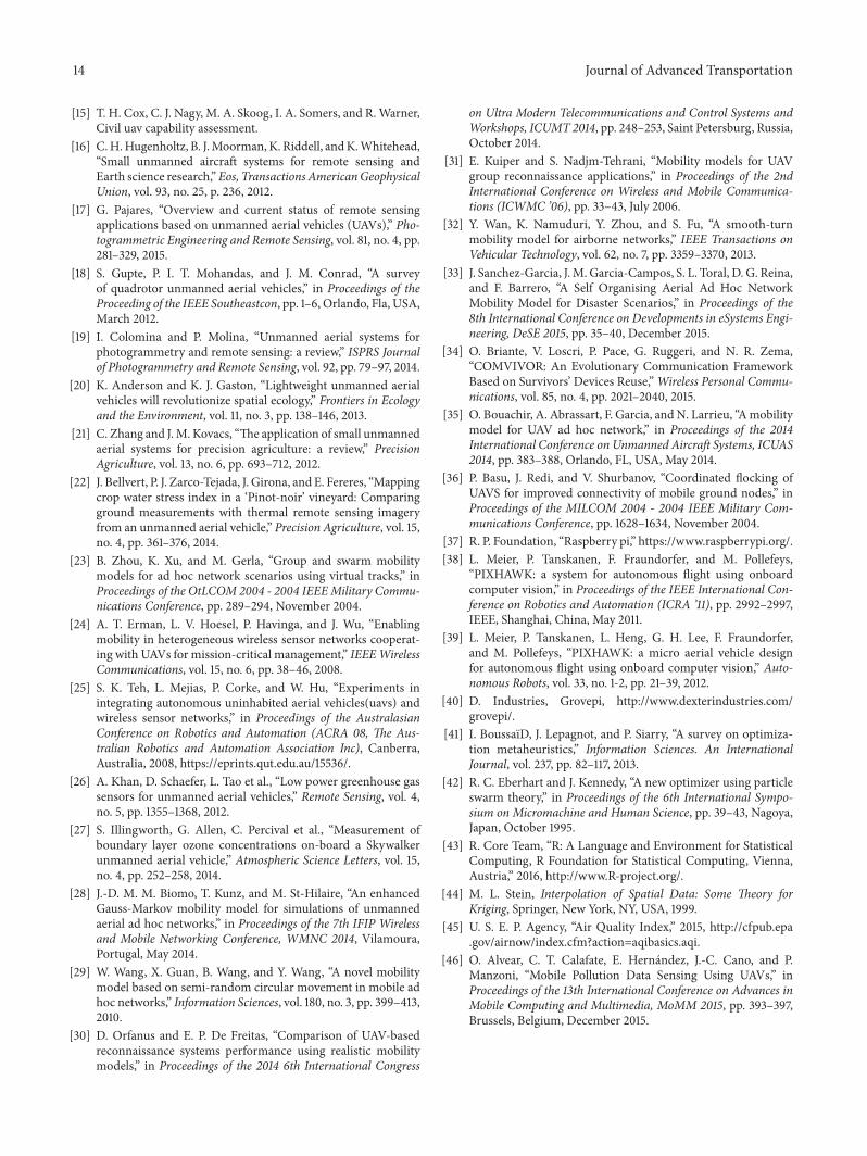