using seismic attributes in seismotectonic research: an
TRANSCRIPT
Solid Earth, 11, 329–348, 2020https://doi.org/10.5194/se-11-329-2020© Author(s) 2020. This work is distributed underthe Creative Commons Attribution 4.0 License.
Using seismic attributes in seismotectonic research:an application to the Norcia Mw = 6.5 earthquake(30 October 2016) in central ItalyMaurizio Ercoli1,4, Emanuele Forte2, Massimiliano Porreca1,4, Ramon Carbonell3, Cristina Pauselli1,4,Giorgio Minelli1,4, and Massimiliano R. Barchi1,4
1Dip. di Fisica e Geologia – Università degli Studi di Perugia, Perugia, Italy2Dept. of Mathematics and Geosciences, University of Trieste, Trieste, Italy3Dept. Structure & Dynamics of the Earth, CSIC-Inst. Earth Sciences Jaume Almera, Barcelona, Spain4Interuniversity Center for Research on 3D-Seismotectonics (Centro InterRUniversitario per l’AnalisiSismoTettonica tridimensionale con applicazioni territoriali – CRUST), Chieti Scalo, Italy
Correspondence: Maurizio Ercoli ([email protected], [email protected])
Received: 9 June 2019 – Discussion started: 27 June 2019Revised: 23 January 2020 – Accepted: 4 February 2020 – Published: 16 March 2020
Abstract. In seismotectonic studies, seismic reflection dataare a powerful tool to unravel the complex deep architectureof active faults. Such tectonic structures are usually mappedat the surface through traditional geological surveying, whilstseismic reflection data may help to trace their continuationfrom the near surface down to hypocentral depths. On seis-mic reflection data, seismic attributes are commonly used bythe oil and gas industry to aid exploration. In this study, wepropose using seismic attributes in seismotectonic researchfor the first time. The study area is a geologically complexregion of central Italy, struck during 2016–2017 by a long-lasting seismic sequence, including a Mw 6.5 main shock.Three vintage seismic reflection profiles are currently theonly ones available at the regional scale across the epicen-tral zone. These represent a singular opportunity to attempt aseismic attribute analysis by running attributes like the “en-ergy” and the “pseudo-relief”. Our results are critical, as theyprovide information on the relatively deep structural setting,mapping a prominent, high-amplitude regional reflector in-terpreted as the top of basement, which is an important rhe-ological boundary. Complex patterns of high-angle disconti-nuities crossing the reflectors have also been identified byseismic attributes. These steeply dipping fabrics are inter-preted as the expression of fault zones belonging to the ac-tive normal fault systems responsible for the seismicity ofthe region. Such peculiar seismic signatures of faulting are
consistent with the principal geological and tectonic struc-tures exposed at surface. In addition, we also provide con-vincing evidence of an important primary tectonic structurecurrently debated in the literature (the Norcia antithetic fault)as well as several buried secondary fault splays. This workdemonstrates that seismic attribute analysis, even if used onlow-quality vintage 2D data, may contribute to improving thesubsurface geological interpretation in areas characterized bylimited and/or low-quality subsurface data but with poten-tially high seismic hazard.
1 Introduction
Studying the connections between earthquakes and the faultswith which they are associated is a primary goal of seis-motectonics (Allen et al., 1965; Schwartz and Coppersmith,1984). Within this field, it is generally complex to fill the gapbetween the exposed geology (including the active “geolog-ical faults”) and the seismological data (e.g., focal mecha-nisms, earthquake locations, etc.), indicators of the geometryand kinematics of the seismic source at hypocentral depth(“seismological faults”, sensu Barchi and Mirabella, 2008).The recovery of information on the seismogenic structures atdepth is difficult, primarily due to the lack of high-resolutiongeophysical data and/or well stratigraphy. The lack of these
Published by Copernicus Publications on behalf of the European Geosciences Union.
330 M. Ercoli et al.: Using seismic attributes in seismotectonic research
data results in relatively high degrees of uncertainty anddrives contrasting geological models and interpretations.
Different geophysical methods (e.g., active and passiveseismology, gravimetry, magnetics, electrics, and electro-magnetics such as magnetotellurics and ground-penetratingradar) may contribute to defining the stratigraphy and struc-tural setting of the upper crust at different scales. The dataprovided by the seismic reflection technique are not directlyaffected by well-known inversion problems typical of the po-tential methods (Snieder and Trampert, 1999) and are largelythe most powerful tool able to produce high-resolution im-ages of the subsurface. This type of data, if calibrated withdeep well stratigraphy, provides very strong constraints onthe definition of subsurface geological architecture. Theseprofiles are useful to unveil the deep geometry of activefaults mapped in the field and extend them down to hypocen-tral depths. Unfortunately, the ex novo acquisition (possibly3D) of onshore deep seismic reflection data for research pur-poses is hampered by high costs, environmental problems,and complex logistics (e.g., prohibition of dynamite or vibro-seis trucks in natural parks or urban areas). Significant excep-tions are research projects for deep crustal investigations likeBIRPS (Brewer et al., 1983), CoCORP (Cook et al., 1979),ECORS (Roure et al., 1989), CROP (Barchi et al., 1998;Finetti et al., 2001), IBERSEIS (Simancas et al., 2003), andALCUDIA (Ehsan et al., 2014, 2015) among others. In seis-mically active regions, old profiles (legacy data) acquired bythe industry have been successfully used to connect the activefaults mapped at the surface with the earthquake seismogenicsources depicted by seismological records (Boncio et al.,2000; Bonini et al., 2014; Carvalho et al., 2008; Beidinger etal., 2011; Maesano et al., 2015; Porreca et al., 2018). Legacyseismic lines have, in fact, some advantages: (1) they are al-ready available from oil companies and national archives; (2)they represent a nice source of information in places wherenew data are difficult to acquire; and (3) they can be used tobuild up and refine geological models. Moreover, such dataare often the only ones available. Therefore, these legacy dataare very valuable and it is worth using them to constrain thesubsurface geological setting and to provide new data on ac-tive tectonic structures (see the DISS database; Basili et al.,2008). Vintage profiles can therefore significantly contributeto seismotectonic research, even if characterized by intrinsiclimitations: (i) their location, orientation, and acquisition pa-rameters were not specifically designed for this aim; (ii) theywere collected using relatively old seismic technologies andacquisition and/or processing strategies. Consequently, thesedata were produced with a relatively low signal-to-noise ra-tio (SNR) and low resolution, especially when compared tomodern standards (Manning et al., 2019). In order to improvethe image quality and increase the accuracy of the interpre-tation, two main strategies, ordinarily used by the oil and gasindustry, can be applied to legacy data: (1) reprocessing fromraw data using modern processing strategies and newly de-
signed algorithms and software; (2) using post-stack analysistechniques such as seismic attributes.
An attribute analysis is, perhaps, one of the easiest, cheap-est, and fastest strategies to qualitatively emphasize the geo-physical features and data properties of reflection seismicdatasets, producing benefits particularly in complex geologi-cal areas. A seismic attribute is a quantity derived from seis-mic data (pre-stack and/or post-stack) commonly used to ex-tract additional information that may be unclear in conven-tionally processed seismic lines. Examples of applications ondense 3D seismic volumes produced impressive results, in-cluding the identification of ancient river channels or sets offaults at variable scales (Chopra and Marfurt, 2005; Chopraand Marfurt, 2007, 2008; Marfurt et al., 2011; Hale, 2013;Barnes, 2016; Iacopini et al., 2016; Marfurt, 2018; Wrona etal., 2018; Di and AlRegib, 2019; Naeini and Prindle, 2019).
There are several advantages in using 3D seismic data in-stead of 2D. Advantages of 3D and pitfalls of 2D are ex-tensively discussed in Torvela et al. (2013) and Hutchinson(2016). 2D seismic data are more limited, and 2D post-stackseismic attribute analysis may not provide the same qualityof information as when using 3D (Marfurt and Alves, 2015;Ha et al., 2019). However, the main point is that in the past,it was common to sample study areas inland by 2D gridsof seismic profiles, with full 3D seismic surveys being rare.Hence, it is relevant to extract as much information as possi-ble from 2D data.
In this work, the selected study area is located betweenthe southeastern part of the Umbria–Marche Apennines andthe Laga domain, in the outer northern Apennines (centralItaly) (e.g., Barchi et al., 2001). This area presents ideal char-acteristics to test the application of seismic attributes as anew approach in seismotectonics. In the past, several seismicprofiles were acquired in this region for hydrocarbon explo-ration and were later used to constrain subsurface geologi-cal structures (Bally et al., 1986; Barchi et al., 1991, 1998,2009; Ciaccio et al., 2005; Pauselli et al., 2006; Mirabellaet al., 2008; Bigi et al., 2011). After the 2016–2017 seis-mic sequence, Porreca et al. (2018) provided an updated re-gional geological model based on the interpretation of vin-tage seismic lines. However, remarkable differences in theseismic data quality across the region prevented a straightfor-ward seismic interpretation. Therefore, the present work ex-ploits the use of seismic attributes on three low-quality seis-mic profiles located close to the Mw 6.5 main shock of the2016–2017 seismic sequence. The main goal is to squeezeadditional information from the 2D data, obtaining as manyconstraints as possible on the geological structures responsi-ble for the seismicity in the area by defining the following:
– the geological and structural setting at depth (e.g., thedepth of the basement and its involvement); and
– the trace of potentially seismogenic faults (connectionbetween the active faults mapped at the surface and theearthquake foci).
Solid Earth, 11, 329–348, 2020 www.solid-earth.net/11/329/2020/
M. Ercoli et al.: Using seismic attributes in seismotectonic research 331
Any improvements achievable on the data quality and vi-sualization, for example an increase in the resolution and/oran enhancement of the lateral extent or limits of the seis-mic reflectors, would represent a valuable contribution con-sidering the limited amount of data available in this area.We think that this innovative approach to seismotectonic re-search can be extended to other onshore seismically activeareas in the world, especially if covered only by sparse vin-tage low-quality seismic surveys. In such cases, we thinkseismotectonic research may benefit from the potential andimprovements generated by seismic attributes.
2 Geological framework and seismotectonics of thestudy area
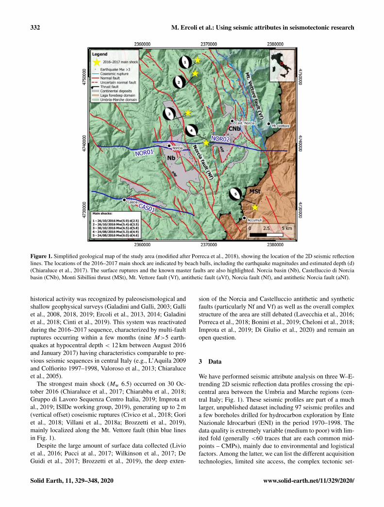
The study area is located in the southeastern part of thenorthern Apennines fold-and-thrust belt. The area includesthe Umbria–Marche domain and the Laga domain, which areseparated by an important regional tectonic structure knownas the Monti Sibillini thrust (MSt) (Fig. 1). The Umbria–Marche domain involves the rocks of the sedimentary cover,represented by three main units (top to bottom), character-ized by different interval velocities (Bally et al., 1986; Barchiet al., 1998; Porreca et al., 2018).
1. On top is the Laga sequence (late Messinian–lowerPliocene, up to 3000 m thick, average seismic velocity;Vav = 4000 m s−1). It consists of siliciclastic turbiditesmade up of alternating layers of sandstones, marls, andevaporites deposited in a marine depositional environ-ment (Milli et al., 2007; Bigi et al., 2011); it outcropsin the eastern sector of the study area (i.e., the Laga do-main).
2. The carbonate formations are next (Jurassic–Oligocene,about 2000 m thick, Vav = 5800 m s−1), formed bypelagic limestones (Mirabella et al., 2008) with subordi-nated marly levels overlying an Early Jurassic carbonateplatform (Calcare Massiccio Fm.). It outcrops mainly inthe Umbria–Marche domain.
3. At the bottom are the Late Triassic evaporites (1500–2500 m thick, Vav = 6400 m s−1). They consist of al-ternated layers of anhydrites and dolomites (Anidritidi Burano Fm. and Raethavicula Contorta beds; Marti-nis and Pieri, 1964), never outcropping and interceptedonly by deep wells (Porreca et al., 2018, and referencestherein).
For further details on the stratigraphic characteristics ofthe area, the reader can refer to the works by Centamore etal. (1992) and Pierantoni et al. (2013).
These units rest on a basement with variable lithology(Permian–Late Triassic, Vav = 5100 m s−1) that never cropsout in the study area (Vai, 2001). It has only been intercepted
by deep wells (Bally et al., 1986; Minelli and Menichetti,1990; Anelli et al., 1994; Patacca and Scandone, 2001).
This sedimentary sequence is involved in the late Miocenefold-and-thrust belt, including a set of N–S-trending anti-clines, formed at the hanging wall of the W-dipping arc-shaped major thrusts. The most important compressionalstructure is the M. Sibillini thrust (MSt; Koopman, 1983;Lavecchia, 1985), where the Umbria–Marche domain isoverthrusted on the Laga domain.
This is a geologically complex region, where in the pastthe analysis of 2D seismic profiles has produced contrastinginterpretations of the upper crust structural setting, i.e., thin-vs. thick-skinned tectonics, fault reactivation and/or inver-sion, and basement depth (Bally et al., 1986; Barchi, 1991;Barchi et al., 2001; Bigi et al., 2011; Calamita et al., 2012). Areview of the geological history of this area has recently beenprovided by Porreca et al. (2018). These authors propose atectonic style characterized by the coexistence of thick- andthin-skinned tectonics with multiple detachments localized atdifferent structural levels.
These compressional structures have later been dis-rupted by extensional faults since the late Pliocene (Fig. 1)(Blumetti et al., 1993; Boncio et al., 1998; Brozzetti andLavecchia, 1994; Calamita and Pizzi, 1994; Pierantoni et al.,2013).
The late Pliocene–Quaternary extensional tectonic phase,characterized by NNW–SSE-striking normal faults, is con-sistent with the present-day active strain field as deduced bygeodetic data (e.g., Anderlini et al., 2016). The latter faultshave high dip angles (50–70◦) and can be synthetic or an-tithetic normal structures (WSW- or ENE-dipping, respec-tively). These faults were also responsible of the tectono-sedimentary evolution of intra-mountain continental basins(Calamita and Pizzi, 1992; Cavinato and De Celles, 1999).The most evident Quaternary basins of this part of theApennines are the Castelluccio di Norcia and Norcia basins(Fig. 1), located at 1270 and 700 m a.s.l., here named CNband Nb, respectively. A phase of lacustrine and fluvial sed-imentation infilled both basins with hundreds of meters ofdeposits, characterized by fine clayey to coarse-grained ma-terial (Blumetti et al., 1993; Coltorti and Farabollini, 1995).
The area is affected by frequent moderate-magnitudeearthquakes (5<Mw<7) and has a high seismogenic poten-tial revealed by both historical and instrumental data (e.g.,Barchi et al., 2000; Boncio and Lavecchia, 2000; Basili etal., 2008; Rovida et al., 2016; DISS Working Group, 2018).The major seismogenic structures recognized in the area arethe Norcia fault (Nf) and the M. Vettore fault (Vf). The Nor-cia fault (Nf; Fig. 1) is associated with several historicalevents (Galli et al., 2005; Pauselli et al., 2010; Rovida et al.,2016), probably including the 1979 earthquake (Nottoria–Preci fault; Deschamps et al., 1984; Brozzetti and Lavec-chia, 1994; Rovida et al., 2016) and the largest event in 1703(Me = 6.8; Rovida et al., 2016). The Vettore fault (Vf) ispart of the easternmost alignment whose historical and pre-
www.solid-earth.net/11/329/2020/ Solid Earth, 11, 329–348, 2020
332 M. Ercoli et al.: Using seismic attributes in seismotectonic research
Figure 1. Simplified geological map of the study area (modified after Porreca et al., 2018), showing the location of the 2D seismic reflectionlines. The locations of the 2016–2017 main shock are indicated by beach balls, including the earthquake magnitudes and estimated depth (d)(Chiaraluce et al., 2017). The surface ruptures and the known master faults are also highlighted. Norcia basin (Nb), Castelluccio di Norciabasin (CNb), Monti Sibillini thrust (MSt), Mt. Vettore fault (Vf), antithetic fault (aVf), Norcia fault (Nf), and antithetic Norcia fault (aNf).
historical activity was recognized by paleoseismological andshallow geophysical surveys (Galadini and Galli, 2003; Galliet al., 2008, 2018, 2019; Ercoli et al., 2013, 2014; Galadiniet al., 2018; Cinti et al., 2019). This system was reactivatedduring the 2016–2017 sequence, characterized by multi-faultruptures occurring within a few months (nine M>5 earth-quakes at hypocentral depth < 12 km between August 2016and January 2017) having characteristics comparable to pre-vious seismic sequences in central Italy (e.g., L’Aquila 2009and Colfiorito 1997–1998, Valoroso et al., 2013; Chiaraluceet al., 2005).
The strongest main shock (Mw 6.5) occurred on 30 Oc-tober 2016 (Chiaraluce et al., 2017; Chiarabba et al., 2018;Gruppo di Lavoro Sequenza Centro Italia, 2019; Improta etal., 2019; ISIDe working group, 2019), generating up to 2 m(vertical offset) coseismic ruptures (Civico et al., 2018; Goriet al., 2018; Villani et al., 2018a; Brozzetti et al., 2019),mainly localized along the Mt. Vettore fault (thin blue linesin Fig. 1).
Despite the large amount of surface data collected (Livioet al., 2016; Pucci at al., 2017; Wilkinson et al., 2017; DeGuidi et al., 2017; Brozzetti et al., 2019), the deep exten-
sion of the Norcia and Castelluccio antithetic and syntheticfaults (particularly Nf and Vf) as well as the overall complexstructure of the area are still debated (Lavecchia et al., 2016;Porreca et al., 2018; Bonini et al., 2019; Cheloni et al., 2018;Improta et al., 2019; Di Giulio et al., 2020) and remain anopen question.
3 Data
We have performed seismic attribute analysis on three W–E-trending 2D seismic reflection data profiles crossing the epi-central area between the Umbria and Marche regions (cen-tral Italy; Fig. 1). These seismic profiles are part of a muchlarger, unpublished dataset including 97 seismic profiles anda few boreholes drilled for hydrocarbon exploration by EnteNazionale Idrocarburi (ENI) in the period 1970–1998. Thedata quality is extremely variable (medium to poor) with lim-ited fold (generally <60 traces that are each common mid-points – CMPs), mainly due to environmental and logisticalfactors. Among the latter, we can list the different acquisitiontechnologies, limited site access, the complex tectonic set-
Solid Earth, 11, 329–348, 2020 www.solid-earth.net/11/329/2020/
M. Ercoli et al.: Using seismic attributes in seismotectonic research 333
ting, and especially the different (and contrasting) outcrop-ping lithologies (e.g., Mazzotti et al., 2000; Mirabella et al.,2008). The eastern area, showing higher data quality, consistsof siliciclastic units of the Laga foredeep sequence, located atthe footwall of the MSt. On the other hand, the lowest SNRrecordings coincide with outcropping carbonate formationsand Quaternary deposits.
The analyzed lines include seismic reflection profilesNOR01 (stack, 14 km long) and NOR02 (time-migrated,20 km long, partially parallel to NOR01 on the western sec-tor), located to the west and east of the Nb, respectively,and CAS01 (stack, 16 km long), located further to the southcrossing Cascia village (Fig. 1).
NOR01 and CAS01 were acquired using a vibroseissource, while explosives were used for NOR02; all the linesare displayed in two-way travel time (TWT) limited to 4.5 s.The amplitude–frequency spectra (computed on the entiretime window) of the processed lines show a bandwidth ina range of 10–50 Hz, with the NOR02 spectrum displayinga slightly higher-frequency content (Table 1). Assuming anaverage peak frequency of 20 Hz, a vertical resolution of ca.80 m can be estimated (using an average carbonate velocityof 6 km s−1; parameters in Table 1). Some processing arti-facts are visible in NOR01 as a horizontal signal at ca. 1 s(yellow dashed line and label A in Fig. 2a) and another inCAS01 (Fig. 3a). As suggested in the Introduction, the in-terpretation could benefit from the application of seismic at-tributes to the seismic images. However, different sets of pa-rameters need to be tested to achieve relevant improvements.Therefore, we loaded the profiles into the software Opend-Tect (OdT; https://www.dgbes.com/index.php/software#free,last access: January 2019). A common seismic datum of500 m was considered for the transect. Unfortunately, deepborehole stratigraphy is not available for the study area (alldetails about surrounding deep wells have already been sum-marized in Porreca et al., 2018). The OdT seismic projectwas also enriched by ancillary data, extracted by a comple-mentary geographic information system (GIS) project (QGis;https://www.qgis.org/it/site/, last access: January 2019). Asis visible in Fig. 1, we have included a detailed summaryof the main normal faults and surface ruptures of the area(Civico et al., 2018; Villani et al., 2018a; Brozzetti et al.,2019), obtained after carefully checking the most importantregional geological maps and fault patterns (Koopman, 1983;Centamore et al., 1993; Pierantoni et al., 2013; Carta Geo-logica Regionale 1 : 10000 – Regione Marche, 2014; CartaGeologica Regionale 1 : 10000 – Regione Umbria, 2016;Ithaca database, http://www.isprambiente.gov.it/it/progetti/suolo-e-territorio-1/ithaca-catalogo-delle-faglie-capaci, lastaccess: January 2019), as well as the most recent works pub-lished in the literature (e.g., Brozzetti et al., 2019; Porreca etal., 2020). The topography was also included using a regional10 m resolution digital elevation model (DEM) database(Tarquini et al., 2007, 2012). The other important externaldataset consists of seismological data, i.e., the inferred loca-
tion and approximated fault geometry as suggested by the fo-cal mechanisms of the main shocks and by the distribution ofthe aftershocks (Iside database; http://iside.rm.ingv.it/iside/(last access: January 2019); Chiaraluce et al., 2017). The in-tegration of such information in a pseudo-3D environmentoffered us a multidisciplinary platform to clearly display theseismic lines and establish links between surface data andthe interpreted deep geologic structures located at hypocen-tral depths.
4 Methods
Seismic reflection data interpretation is generally accom-plished by correlating specific signal characteristics (seis-mic signature) with the different geological domains iden-tified within the study area. A standard seismic interpretationis affected by a certain degree of uncertainty and/or subjec-tivity (particularly in the case of poor data quality) becauseit is generally based on a qualitative analysis of the ampli-tude, geometry, and lateral continuity of the reflections. Overthe last years, the introduction of seismic attributes and re-lated automated–semiautomated procedures has had an im-portant role in reducing the subjectivity of seismic interpre-tations and achieving quantitative results. A seismic attributeis a descriptive and quantifiable parameter that can be cal-culated on a single trace, on multiple traces, or 3D volumesand can be displayed at the same scale as the original data.Seismic data can therefore be considered a composition ofconstituent attributes (Barnes, 2000; Taner et al., 1979; Forteet al., 2012). Their benefits were first appreciated in 2D and3D seismic reflection data (Barnes, 1996, 2000; Taner et al.,1979; Chen and Sidney, 1997; Taner, 2001; Chopra and Mar-furt, 2007, 2008; Iacopini and Butler, 2011; Iacopini et al.,2012; McArdle et al., 2014; Botter et al., 2014; Hale, 2013,for a review; Marfurt and Alves, 2015; Forte et al., 2016) and,more recently, have also been appreciated in other subsur-face imaging techniques like ground-penetrating radar (e.g.,McClymont et al., 2008; Forte et al., 2012; Ercoli et al.,2015; Lima et al., 2018). In this work, we have tested severalpost-stack attributes on three 2D vintage seismic lines (orig-inal seismic data in the Supplement in Fig. S1). We startedour analysis by first using well-known and widely used at-tributes like instantaneous amplitude, phase, frequency, andtheir combinations. We also used composite multi-attributedisplays (i.e., simultaneous overlay and display of differentattributes, e.g., primarily phase, frequency, envelope; Chopraand Marfurt, 2005, 2011). Later on, we also tested other at-tributes like coherency and similarity, which are generallymore efficient on 3D volumes. These did not result in positiveoutcomes due to the limited vertical and lateral resolutionof our legacy data. Among the tested attributes, we selectedthree that resulted in the best images (provided in Figs. S2,S3, and S4 of the Supplement, without any line drawing orlabels), aiding the detection of peculiar seismic signatures
www.solid-earth.net/11/329/2020/ Solid Earth, 11, 329–348, 2020
334 M. Ercoli et al.: Using seismic attributes in seismotectonic research
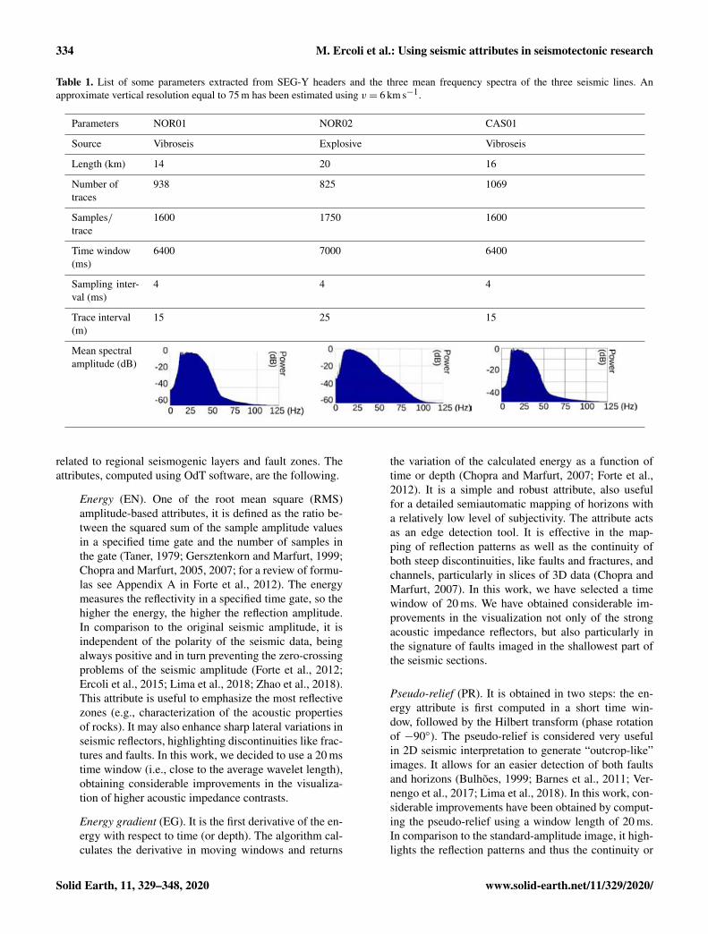
Table 1. List of some parameters extracted from SEG-Y headers and the three mean frequency spectra of the three seismic lines. Anapproximate vertical resolution equal to 75 m has been estimated using v = 6 km s−1.
Parameters NOR01 NOR02 CAS01
Source Vibroseis Explosive Vibroseis
Length (km) 14 20 16
Number oftraces
938 825 1069
Samples/trace
1600 1750 1600
Time window(ms)
6400 7000 6400
Sampling inter-val (ms)
4 4 4
Trace interval(m)
15 25 15
Mean spectralamplitude (dB)
related to regional seismogenic layers and fault zones. Theattributes, computed using OdT software, are the following.
Energy (EN). One of the root mean square (RMS)amplitude-based attributes, it is defined as the ratio be-tween the squared sum of the sample amplitude valuesin a specified time gate and the number of samples inthe gate (Taner, 1979; Gersztenkorn and Marfurt, 1999;Chopra and Marfurt, 2005, 2007; for a review of formu-las see Appendix A in Forte et al., 2012). The energymeasures the reflectivity in a specified time gate, so thehigher the energy, the higher the reflection amplitude.In comparison to the original seismic amplitude, it isindependent of the polarity of the seismic data, beingalways positive and in turn preventing the zero-crossingproblems of the seismic amplitude (Forte et al., 2012;Ercoli et al., 2015; Lima et al., 2018; Zhao et al., 2018).This attribute is useful to emphasize the most reflectivezones (e.g., characterization of the acoustic propertiesof rocks). It may also enhance sharp lateral variations inseismic reflectors, highlighting discontinuities like frac-tures and faults. In this work, we decided to use a 20 mstime window (i.e., close to the average wavelet length),obtaining considerable improvements in the visualiza-tion of higher acoustic impedance contrasts.
Energy gradient (EG). It is the first derivative of the en-ergy with respect to time (or depth). The algorithm cal-culates the derivative in moving windows and returns
the variation of the calculated energy as a function oftime or depth (Chopra and Marfurt, 2007; Forte et al.,2012). It is a simple and robust attribute, also usefulfor a detailed semiautomatic mapping of horizons witha relatively low level of subjectivity. The attribute actsas an edge detection tool. It is effective in the map-ping of reflection patterns as well as the continuity ofboth steep discontinuities, like faults and fractures, andchannels, particularly in slices of 3D data (Chopra andMarfurt, 2007). In this work, we have selected a timewindow of 20 ms. We have obtained considerable im-provements in the visualization not only of the strongacoustic impedance reflectors, but also particularly inthe signature of faults imaged in the shallowest part ofthe seismic sections.
Pseudo-relief (PR). It is obtained in two steps: the en-ergy attribute is first computed in a short time win-dow, followed by the Hilbert transform (phase rotationof −90◦). The pseudo-relief is considered very usefulin 2D seismic interpretation to generate “outcrop-like”images. It allows for an easier detection of both faultsand horizons (Bulhões, 1999; Barnes et al., 2011; Ver-nengo et al., 2017; Lima et al., 2018). In this work, con-siderable improvements have been obtained by comput-ing the pseudo-relief using a window length of 20 ms.In comparison to the standard-amplitude image, it high-lights the reflection patterns and thus the continuity or
Solid Earth, 11, 329–348, 2020 www.solid-earth.net/11/329/2020/

M. Ercoli et al.: Using seismic attributes in seismotectonic research 335
discontinuity of reflectors, enhancing steep discontinu-ities and fault zones.
5 Results
Figures 2, 3, and 4 show the comparison between the originalseismic lines in amplitude and the images obtained after theattribute analysis, revealing significant improvements in thevisualization and interpretability of the geophysical features.In profiles NOR01, CAS01, and NOR02 we focus our anal-ysis on three types of geophysical features highlighted bythe attributes: subhorizontal deep reflectors, low-angle dis-continuities, and high-angle discontinuities. The main faultsknown at the surface (Fig. 1) have also been plotted on top ofeach seismic line.
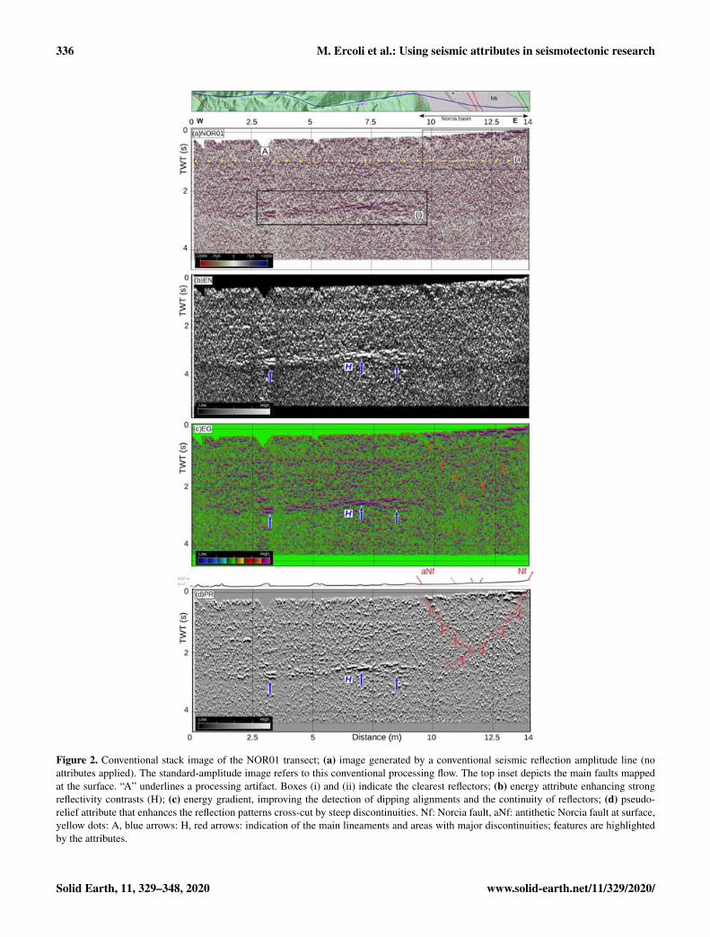
In the original seismic line NOR01 (Fig. 2a), the overalllow SNR hampers the detection of clear and continuous re-flectors. At ca. 1 s, a horizontal processing artifact is visi-ble (label A, yellow dots), possibly related to a windowedfilter. The most prominent subhorizontal reflections (labeledH) are located in the central portion between 2 and 3 s (TWT)(strong reflectors in black box i). Shallower and less contin-uous reflectors are also visible in the eastern side of the pro-file, beneath the Nb (black box ii). The EN attribute (Fig. 2b)enhances the reflectivity contrast, better focusing the high-amplitude, gently W-dipping reflector H (blue arrows) andalso outlining its lateral extension. In this image most of thereflected energy is concentrated on its top at ca. 2.5 s; it isreadily apparent that H separates two seismic facies, witha higher-amplitude (top) and lower-amplitude (bottom) re-sponse, respectively. The EG and PR attributes of NOR01(Fig. 2c, d) better display the geometry of horizon H, charac-terized by a continuous, ca. 8 km long package of reflectors(ca. 200 ms thick) having common characteristics in terms ofreflection strength and period. In the eastern part of the pro-file, below the Nb, the EG and PR attributes also enhance twomajor opposite-dipping high-angle geophysical features (redarrows in Fig. 2c and d), crossing and disrupting the shal-lower reflectors. The W-dipping lineament propagates downto ca. 2.5 s, intercepting the eastern termination of the reflec-tor H. The two discontinuities define a relatively transparent,shallow seismic facies, corresponding to the area where theNb outcrops. In the same sector, the reflectors are pervasivelydisrupted by many other minor discontinuities.
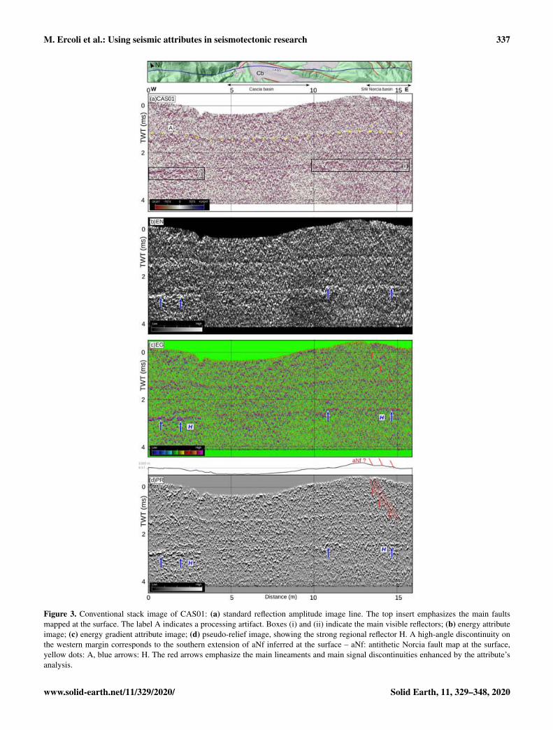
The original seismic reflection line CAS01 (Fig. 3a) dis-plays a generalized high-frequency noise content. As inNOR01, a shallow processing artifact (A, yellow dots) is vis-ible and possibly related to the application of a windowedfilter. Fragmented packages of high-amplitude reflectors (H)are visible at the same time interval observed in NOR01 (ca.2.5 s) in both the western (black box i; Fig. 3a) and, morediscontinuously, in the eastern part of the line (black boxii; Fig. 3a). The EN attribute (Fig. 3b) emphasizes the pres-ence of the H reflector, better focusing its reflectivity (blue
arrows). Both the EG and PR attributes (Fig. 3c and d) fur-ther help to delineate the reflector H. The steeper disconti-nuities have been analyzed mainly in the western part of theprofile, closer to the 2016–2017 seismically active area. Amajor high-angle, east-dipping discontinuity has been tracedat about 13 km (alignment of red arrows in Fig. 3c and d).
The original seismic line NOR02 (Fig. 4a) displays geo-physical features similar to the ones detected in NOR01 andCAS01. This seismic profile shows a generalized poor or lim-ited lateral continuity of the reflectors, with the exceptionof the eastern side. In this sector, a set of west-dipping co-herent reflections can be recognized: the higher SNR corre-lates with the outcropping turbidites of the Laga sequence,which are known to favor the seismic energy penetrationand reflection in comparison to carbonates (e.g., Bally et al.,1986; Barchi et al., 1998). The prominent reflection H, gen-tly east-dipping and relatively continuous for more than 8 km(black box in Fig. 4a), is located in the center of the line ata greater depth (3.2–3.5 s TWT) with respect to the previ-ously described NOR01 and CAS01 profiles. As in the pre-vious cases, the EN attribute (Fig. 4b) effectively focuses thereflectivity of the horizons, emphasizing the high amplitudeof the reflector H (blue arrows). The EG and PR attributes(Fig. 4c and d) improve the overall visualization of the re-flection patterns, aiding the detection of the low-angle andhigh-angle discontinuities. A major westward low-angle dis-continuity T (green dots in Fig. 4c and d) crosses the entireprofile, descending from ca. 2 s (east) to ca. 4 s (west), whereit intersects the reflector H. Several high-angle discontinu-ities have been traced along the section, marked by the align-ments of red arrows in Fig. 4c and d. The most relevant align-ments have been recognized beneath the two major Quater-nary basins (i.e., Nb and CNb) crossed by the profile: in bothcases, major W-dipping alignments can be traced from thenear surface, where they correspond to the eastern border ofthe abovementioned basins, down to a depth of ca. 4 s TWT.Other discontinuities, W- and E-dipping, have been traced inthe hanging wall of these two major alignments. In the seis-mic line sector bounded by these features, many secondary(minor) discontinuities pervasively cross-cut the set of reflec-tors, producing a densely fragmented pattern. Unfortunately,the limited resolution and data quality in the deeper part ofthe section hampers an univocal interpretation of the cross-cutting relationships between the low-angle discontinuity Tand the W-dipping high-angle discontinuity: two alternativeinterpretations are possible, which will be discussed in detailin Sect. 6.
The global improvement in the dataset interpretability canbe better appreciated in a 3D visualization of the seismic at-tributes, also using multi-attribute displays (Fig. 5). Such im-ages reveal the deep geometry of the main reflectors and thelocation of the geophysical discontinuities, later interpretedin light of known and debated tectonic structures on the studyarea. In Fig. 5a we report a 3D perspective of the seismicline NOR02, after combining the EN attribute with the PR
www.solid-earth.net/11/329/2020/ Solid Earth, 11, 329–348, 2020
336 M. Ercoli et al.: Using seismic attributes in seismotectonic research
Figure 2. Conventional stack image of the NOR01 transect; (a) image generated by a conventional seismic reflection amplitude line (noattributes applied). The standard-amplitude image refers to this conventional processing flow. The top inset depicts the main faults mappedat the surface. “A” underlines a processing artifact. Boxes (i) and (ii) indicate the clearest reflectors; (b) energy attribute enhancing strongreflectivity contrasts (H); (c) energy gradient, improving the detection of dipping alignments and the continuity of reflectors; (d) pseudo-relief attribute that enhances the reflection patterns cross-cut by steep discontinuities. Nf: Norcia fault, aNf: antithetic Norcia fault at surface,yellow dots: A, blue arrows: H, red arrows: indication of the main lineaments and areas with major discontinuities; features are highlightedby the attributes.
Solid Earth, 11, 329–348, 2020 www.solid-earth.net/11/329/2020/
M. Ercoli et al.: Using seismic attributes in seismotectonic research 337
Figure 3. Conventional stack image of CAS01: (a) standard reflection amplitude image line. The top insert emphasizes the main faultsmapped at the surface. The label A indicates a processing artifact. Boxes (i) and (ii) indicate the main visible reflectors; (b) energy attributeimage; (c) energy gradient attribute image; (d) pseudo-relief image, showing the strong regional reflector H. A high-angle discontinuity onthe western margin corresponds to the southern extension of aNf inferred at the surface – aNf: antithetic Norcia fault map at the surface,yellow dots: A, blue arrows: H. The red arrows emphasize the main lineaments and main signal discontinuities enhanced by the attribute’sanalysis.
www.solid-earth.net/11/329/2020/ Solid Earth, 11, 329–348, 2020

338 M. Ercoli et al.: Using seismic attributes in seismotectonic research
Figure 4. Time-migrated image of the NOR02 profile; (a) standard reflection amplitude image of the profile. The inset indicates the mainfaults mapped at the surface; box (i) points out the most visible reflector. (b) Energy attribute image displaying the reflector H and a possiblelow-angle discontinuity (T); (c) energy gradient attribute image, showing the main lineaments detected; (d) pseudo-relief attribute image,improving the continuity or discontinuity of the reflectors and the display of the areas with main signal discontinuities (red polygon) afterthe attribute computation. Nf: Norcia fault, aNf: antithetic Norcia fault, Vf: Mt. Vettore fault, aVf: antithetic Mt. Vettore fault at the surface,yellow dots: A, blue arrows: H, green dots: T, red arrows: indication of the main lineaments.
Solid Earth, 11, 329–348, 2020 www.solid-earth.net/11/329/2020/
M. Ercoli et al.: Using seismic attributes in seismotectonic research 339
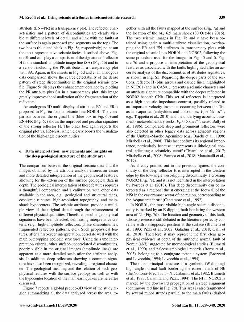
attribute (EN+PR) in a transparency plot. The reflector char-acteristics and a pattern of discontinuities are clearly visi-ble at different levels of detail, and a link with the faults atthe surface is again proposed (red segments on the top). Thetwo boxes (blue and black in Fig. 5a, respectively) point outthe most representative seismic facies described above. Fig-ure 5b and c display a comparison of the signature of reflectorH in the standard-amplitude image line (SA) (Fig. 5b) and ina version including the PR attribute in a transparency plotwith SA. Again, in the inserts in Fig. 5d and e, an analogousdata comparison shows the scarce detectability of the densepattern of steep discontinuities in the original seismic pro-file. Figure 5e displays the enhancement obtained by plottingthe PR attribute plus SA in a transparency plot; this imagegreatly improves the visualization of the fragmentation of thereflectors.
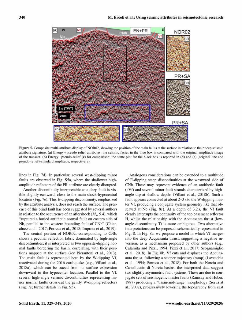
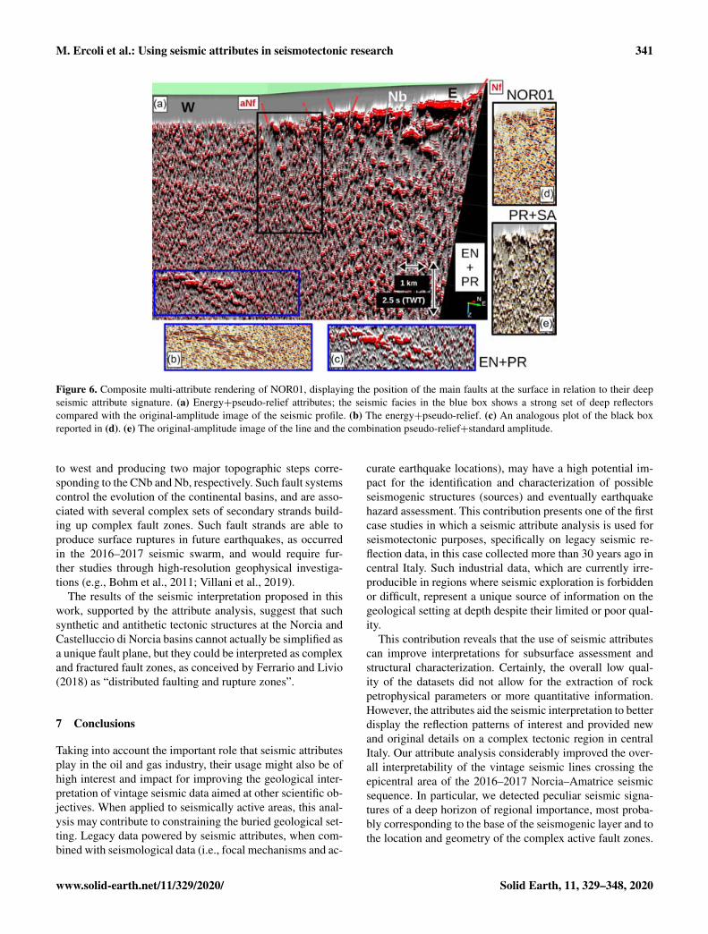
An analogous 3D multi-display of attributes EN and PR isproposed in Fig. 6a for the seismic line NOR01. The com-parison between the original line (blue box in Fig. 6b) andEN+PR (Fig. 6c) shows the improved and peculiar signatureof the strong reflector H. The black box again reports theoriginal plot vs. PR+SA, which clearly boosts the visualiza-tion of the high-angle discontinuities.
6 Data interpretation: new elements and insights onthe deep geological structure of the study area
The comparison between the original seismic data and theimages obtained by the attribute analysis ensures an easierand more detailed interpretation of the geophysical features,allowing for the extension of the surface geological data indepth. The geological interpretation of these features requiresa thoughtful comparison and a calibration with other dataavailable in the area, e.g., geological and structural maps,coseismic ruptures, high-resolution topography, and main-shock hypocenters. The seismic attributes provide a multi-ple view of the original data through the enhancement ofdifferent physical quantities. Therefore, peculiar geophysicalsignatures have been detected, delineating interpretative cri-teria (e.g., high-amplitude reflectors, phase discontinuities,fragmented reflectors patterns, etc.). Such geophysical fea-tures, after a first-order interpretation, correlate well with themain outcropping geologic structures. Using the same inter-pretation criteria, other surface-uncorrelated discontinuities,poorly visible in the original images (amplitude lines), areapparent at a more detailed scale after the attribute analy-sis. In addition, deep reflectors showing a common signa-ture have also been recognized, revealing a regional charac-ter. The geological meaning and the relation of such geo-physical features with the surface geology as well as withthe hypocenter location of the main earthquakes are hereafterdiscussed.
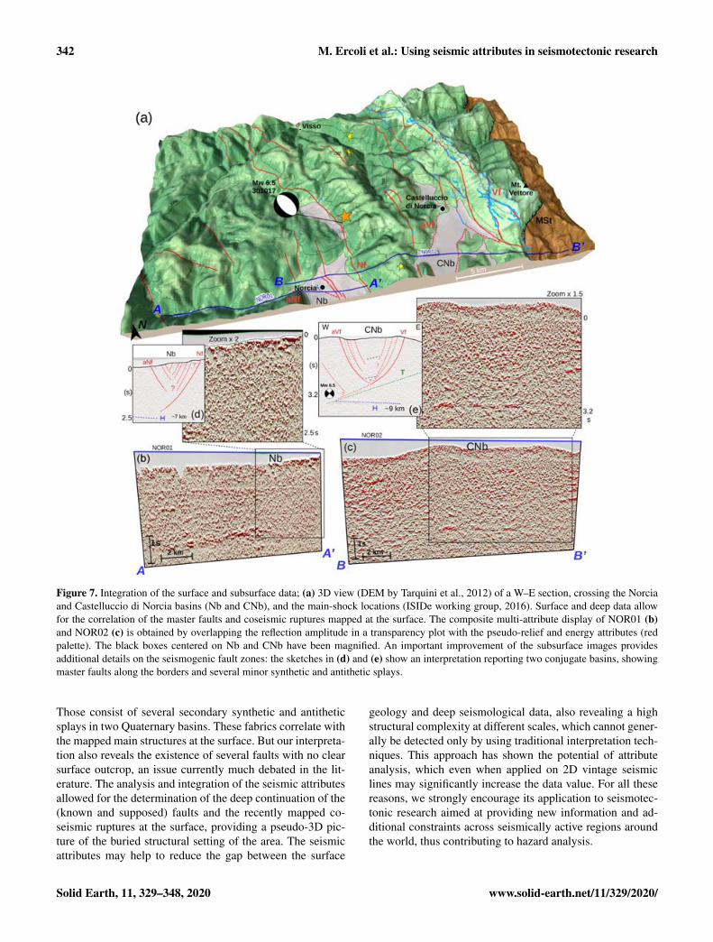
Figure 7 reports a global pseudo-3D view of the study re-gion summarizing all the data analyzed across the area, to-
gether with all the faults mapped at the surface (Fig. 7a) andthe location of the Mw 6.5 main shock (30 October 2016).The two seismic images in Fig. 7b and c have been ob-tained using again a multi-attribute visualization, overlap-ping the PR and EN attributes in transparency plots withthe original seismic lines NOR01 and NOR02, following thesame procedure used for the images in Figs. 5 and 6. Fig-ure 7d and e propose an interpretation of the geophysicalfeatures as associated with the faults highlighted after an ac-curate analysis of the discontinuities of attributes signatures,as shown in Fig. S5. Regarding the deeper parts of the sec-tions, reflector H (blue arrows and dashed line), highlightedin NOR01 (and in CAS01), presents a seismic character andan attribute signature compatible with the deeper reflector inNOR02 beneath CNb. This set of reflectors is interpretedas a high acoustic impedance contrast, possibly related toan important velocity inversion occurring between the Tri-assic evaporites (anhydrites and dolostones, Vp ≈ 6 km s−1;e.g., Trippetta et al., 2010) and the underlying acoustic base-ment (metasedimentary rocks, Vp ≈ 5 km s−1; sensu Bally etal., 1986). Comparable deep and prominent reflectors werealso detected in other legacy data across adjacent regionsof the Umbria–Marche Apennines (e.g., Barchi et al., 1998;Mirabella et al., 2008). This fact confirms its regional impor-tance, particularly because it represents a lithological con-trol indicating a seismicity cutoff (Chiaraluce et al., 2017;Mirabella et al., 2008; Porreca et al., 2018; Mancinelli et al.,2019).
As already pointed out in the previous figures, the con-tinuity of the deep reflector H is interrupted in the westernedge by the low-angle west-dipping discontinuity T crossingNOR02 (Fig. 7e), and it is not identified in the interpretationby Porreca et al. (2018). This deep discontinuity can be in-terpreted as a regional thrust emerging at the footwall of theMSt in the easternmost sector of the region, corresponding tothe Acquasanta thrust (Centamore et al., 1992).
In NOR01, the most visible high-angle seismic disconti-nuity is marked by an E-dipping fault bordering the westernarea of Nb (Fig. 7d). The location and geometry of this fault,whose presence is still debated in the literature, perfectly cor-relate with its supposed position at the surface (Blumetti etal., 1993; Pizzi et al., 2002; Galadini et al., 2018; Galli etal., 2018). Therefore, it may represent the first clear geo-physical evidence at depth of the antithetic normal fault ofNorcia (aNf), suggested by morphological studies (Blumettiet al., 1990) and paleoseismological records (Borre et al.,2003), belonging to a conjugate tectonic system (Brozzettiand Lavecchia, 1994; Lavecchia et al., 1994).
The other principal structure is a synthetic (W-dipping)high-angle normal fault bordering the eastern flank of Nb(the Nottoria–Preci fault – Nf; Calamita et al., 1982; Blumettiet al., 1993; Calamita and Pizzi, 1994). The Nf in NOR02 ismarked by the downward propagation of a steep alignment(continuous red line in Fig. 7d). This area is also fragmentedby several minor strands parallel to the main faults (dashed
www.solid-earth.net/11/329/2020/ Solid Earth, 11, 329–348, 2020
340 M. Ercoli et al.: Using seismic attributes in seismotectonic research
Figure 5. Composite multi-attribute display of NOR02, showing the position of the main faults at the surface in relation to their deep seismicattribute signature. (a) Energy+pseudo-relief attributes; the seismic facies in the blue box is compared with the original amplitude imageof the transect. (b) Energy+pseudo-relief (c) for comparison; the same plot for the black box is reported in (d) and (e) (original line andpseudo-relief+standard amplitude, respectively).
lines in Fig. 7d). In particular, several west-dipping minorfaults are observed in Fig. S5a, where the shallower high-amplitude reflectors of the PR attribute are clearly disrupted.
Another discontinuity interpretable as a deep fault is vis-ible slightly eastward, close to the main-shock hypocentrallocation (Fig. 7e). This E-dipping discontinuity, emphasizedby the attribute analysis, does not reach the surface. The pres-ence of this blind fault has been suggested by several authorsin relation to the occurrence of an aftershock (Mw 5.4), which“ruptured a buried antithetic normal fault on eastern side ofNb, parallel to the western bounding fault of CNb” (Chiar-aluce et al., 2017; Porreca et al., 2018; Improta et al., 2019).
The central portion of NOR02, corresponding to CNb,shows a peculiar reflection fabric dominated by high-anglediscontinuities; it is interpreted as two opposite-dipping nor-mal faults bordering the basin, correlating with their posi-tions mapped at the surface (see Pierantoni et al., 2013).The main fault is represented here by the W-dipping Vf,reactivated during the 2016 earthquake (e.g., Villani et al.,2018a), which can be traced from its surface expressiondownward to the hypocenter location. Parallel to the Vf,several high-angle seismic discontinuities representing mi-nor normal faults cross-cut the gently W-dipping reflectors(Fig. 7e; further details in Fig. S5).
Analogous considerations can be extended to a multitudeof E-dipping steep discontinuities at the westward side ofCNb. These may represent evidence of an antithetic fault(aVf) and several minor fault strands characterized by high-angle dip at shallow depths (Villani et al., 2018b). Such afault appears connected at about 2–3 s to the W-dipping mas-ter Vf, producing a conjugate system geometry like that ob-served at Nb (Fig. 8e). At a depth of 3.2 s, the Vf faultclearly interrupts the continuity of the top basement reflectorH, whilst the relationship with the Acquasanta thrust (low-angle discontinuity T) is more ambiguous. Two alternativeinterpretations can be proposed, schematically represented inFig. 8. In Fig. 8a, we propose a model in which Vf mergesinto the deep Acquasanta thrust, suggesting a negative in-version, as a mechanism proposed by other authors (e.g.,Calamita and Pizzi, 1994; Pizzi et al., 2017; Scognamiglioet al., 2018). In Fig. 8b, Vf cuts and displaces the Acquas-anta thrust, following a steeper trajectory (ramp) (Lavecchiaet al., 1994; Porreca et al., 2018). For both the Norcia andCastelluccio di Norcia basins, the interpreted data suggesttwo slightly asymmetric fault systems. These are due to con-jugate sets of seismogenic master faults (Ramsay and Huber,1987) producing a “basin-and-range” morphology (Serva atal., 2002), progressively lowering the topography from east
Solid Earth, 11, 329–348, 2020 www.solid-earth.net/11/329/2020/
M. Ercoli et al.: Using seismic attributes in seismotectonic research 341
Figure 6. Composite multi-attribute rendering of NOR01, displaying the position of the main faults at the surface in relation to their deepseismic attribute signature. (a) Energy+pseudo-relief attributes; the seismic facies in the blue box shows a strong set of deep reflectorscompared with the original-amplitude image of the seismic profile. (b) The energy+pseudo-relief. (c) An analogous plot of the black boxreported in (d). (e) The original-amplitude image of the line and the combination pseudo-relief+standard amplitude.
to west and producing two major topographic steps corre-sponding to the CNb and Nb, respectively. Such fault systemscontrol the evolution of the continental basins, and are asso-ciated with several complex sets of secondary strands build-ing up complex fault zones. Such fault strands are able toproduce surface ruptures in future earthquakes, as occurredin the 2016–2017 seismic swarm, and would require fur-ther studies through high-resolution geophysical investiga-tions (e.g., Bohm et al., 2011; Villani et al., 2019).
The results of the seismic interpretation proposed in thiswork, supported by the attribute analysis, suggest that suchsynthetic and antithetic tectonic structures at the Norcia andCastelluccio di Norcia basins cannot actually be simplified asa unique fault plane, but they could be interpreted as complexand fractured fault zones, as conceived by Ferrario and Livio(2018) as “distributed faulting and rupture zones”.
7 Conclusions
Taking into account the important role that seismic attributesplay in the oil and gas industry, their usage might also be ofhigh interest and impact for improving the geological inter-pretation of vintage seismic data aimed at other scientific ob-jectives. When applied to seismically active areas, this anal-ysis may contribute to constraining the buried geological set-ting. Legacy data powered by seismic attributes, when com-bined with seismological data (i.e., focal mechanisms and ac-
curate earthquake locations), may have a high potential im-pact for the identification and characterization of possibleseismogenic structures (sources) and eventually earthquakehazard assessment. This contribution presents one of the firstcase studies in which a seismic attribute analysis is used forseismotectonic purposes, specifically on legacy seismic re-flection data, in this case collected more than 30 years ago incentral Italy. Such industrial data, which are currently irre-producible in regions where seismic exploration is forbiddenor difficult, represent a unique source of information on thegeological setting at depth despite their limited or poor qual-ity.
This contribution reveals that the use of seismic attributescan improve interpretations for subsurface assessment andstructural characterization. Certainly, the overall low qual-ity of the datasets did not allow for the extraction of rockpetrophysical parameters or more quantitative information.However, the attributes aid the seismic interpretation to betterdisplay the reflection patterns of interest and provided newand original details on a complex tectonic region in centralItaly. Our attribute analysis considerably improved the over-all interpretability of the vintage seismic lines crossing theepicentral area of the 2016–2017 Norcia–Amatrice seismicsequence. In particular, we detected peculiar seismic signa-tures of a deep horizon of regional importance, most proba-bly corresponding to the base of the seismogenic layer and tothe location and geometry of the complex active fault zones.
www.solid-earth.net/11/329/2020/ Solid Earth, 11, 329–348, 2020
342 M. Ercoli et al.: Using seismic attributes in seismotectonic research
Figure 7. Integration of the surface and subsurface data; (a) 3D view (DEM by Tarquini et al., 2012) of a W–E section, crossing the Norciaand Castelluccio di Norcia basins (Nb and CNb), and the main-shock locations (ISIDe working group, 2016). Surface and deep data allowfor the correlation of the master faults and coseismic ruptures mapped at the surface. The composite multi-attribute display of NOR01 (b)and NOR02 (c) is obtained by overlapping the reflection amplitude in a transparency plot with the pseudo-relief and energy attributes (redpalette). The black boxes centered on Nb and CNb have been magnified. An important improvement of the subsurface images providesadditional details on the seismogenic fault zones: the sketches in (d) and (e) show an interpretation reporting two conjugate basins, showingmaster faults along the borders and several minor synthetic and antithetic splays.
Those consist of several secondary synthetic and antitheticsplays in two Quaternary basins. These fabrics correlate withthe mapped main structures at the surface. But our interpreta-tion also reveals the existence of several faults with no clearsurface outcrop, an issue currently much debated in the lit-erature. The analysis and integration of the seismic attributesallowed for the determination of the deep continuation of the(known and supposed) faults and the recently mapped co-seismic ruptures at the surface, providing a pseudo-3D pic-ture of the buried structural setting of the area. The seismicattributes may help to reduce the gap between the surface
geology and deep seismological data, also revealing a highstructural complexity at different scales, which cannot gener-ally be detected only by using traditional interpretation tech-niques. This approach has shown the potential of attributeanalysis, which even when applied on 2D vintage seismiclines may significantly increase the data value. For all thesereasons, we strongly encourage its application to seismotec-tonic research aimed at providing new information and ad-ditional constraints across seismically active regions aroundthe world, thus contributing to hazard analysis.
Solid Earth, 11, 329–348, 2020 www.solid-earth.net/11/329/2020/

M. Ercoli et al.: Using seismic attributes in seismotectonic research 343
Figure 8. The figure proposes two alternative interpretations of the relation between the normal Vf, the deep Acquasanta thrust (T), and thetop basement reflector (H). Panel (a) reports a model in which Vf merges into the deep Acquasanta thrust, suggesting a negative inversion,similar to the models proposed by some authors (e.g., Calamita and Pizzi, 1994; Pizzi et al., 2017; Scognamiglio et al., 2018). In (b), Vf cutsand displaces the Acquasanta thrust, following a steeper trajectory (ramp) as proposed by other researchers (Lavecchia et al., 1994; Porrecaet al., 2018, 2020).
Data availability. The original SEG-Y files were provided by ENIS.p.A. under a temporary agreement. The raw images of the seismicreflection lines are available in the Supplement.
Supplement. The supplement related to this article is available on-line at: https://doi.org/10.5194/se-11-329-2020-supplement.
Author contributions. ME was responsible for conceptualization,data curation, formal analysis, investigation, methodology, soft-ware, validation, visualization, writing the original draft, and reviewand editing.
EF was responsible for methodology, data curation, visualiza-tion, validation, and review and editing.
MP was responsible for conceptualization, data curation, valida-tion, resources, and review and editing.
RC was responsible for methodology, validation, visualization,and review and editing.
CP was responsible for formal analysis, investigation, and reviewand editing.
GM was responsible for resources, visualization, and review andediting.
MRB was responsible for conceptualization, resources, supervi-sion, and review and editing.
Competing interests. The authors declare that they have no conflictof interest.
Acknowledgements. We are grateful to Eni S.p.A. for providing aninedited set of seismic reflection lines after the 2016–2017 seismiccrisis in central Italy (raw data images available in Fig. S1 of theSupplement). The high-resolution Figs. 2, 3, 4, and 7 are available
in the Supplement. The authors are very grateful to dgB Earth Sci-ences and to QGIS teams for providing the academic software usedin this work. We thank Christian Berndt and David Iacopini for theirvaluable comments provided for this paper. We also thank the twoanonymous reviewers for their patience in providing useful sugges-tions and detailed corrections that considerably improved this work.
Review statement. This paper was edited by Mark Allen and re-viewed by two anonymous referees.
References
Allen, C. R., St. Amand, P., Richter, C. F., and Nordquist, J.: Rela-tionship between seismicity and geologic structure in the south-ern California region, Bull. Seismol. Soc. Am., 55, 753–797,1965.
Anderlini, L., Serpelloni, E., and Belardinelli, M. E.: Creep andlocking of a low-angle normal fault: Insights from the Altotibe-rina fault in the Northern Apennines (Italy), Geophys. Res. Lett.,43, 4321–4329, https://doi.org/10.1002/2016GL068604, 2016.
Anelli, L., Gorza, M., Pieri, M., and Riva, M.: Subsurface well datain the Northern Apennines (Italy). Memorie della Società Geo-logica Italiana, 48, 461–471, 1994.
Bally, A. W., Burbi, L., Cooper, C., and Ghelardoni, R.: Balancedcross-sections and seismic reflection profiles across the centralApennines, Memorie della Societa Geologica Italiana, 35, 257–310, 1986.
Barchi, M.: Integration of a seismic profile with surface and sub-surface geology in a cross-section through the Umbria-MarcheApennines, Bollettino della Società Geologica Italiana, 110,469–479, 1991.
Barchi, M., Landuzzi, A., Minelli, G., and Pialli, G.: Outer north-ern Apennines. In anatomy of an orogen: The Apennines and
www.solid-earth.net/11/329/2020/ Solid Earth, 11, 329–348, 2020
344 M. Ercoli et al.: Using seismic attributes in seismotectonic research
adjacent Mediterranean Basins, Netherlands, Springer, 215–253,2001.
Barchi, M. R. and Mirabella, F.: The 1997–98 Umbria-Marche earthquake sequence: “Geological” vs. “seis-mological” faults, Tectonophysics, 476, 170–179,https://doi.org/10.1016/j.tecto.2008.09.013, 2008.
Barchi, M. R., Minelli, G., and Pialli, G.: The CROP 03 Profile:a synthesis of results on deep structures of the Northern Apen-nines, Mem. Soc. Geol. It., 52, 383–400, 1998.
Barchi, M. R., Galadini, F., Lavecchia, G., Messina, P., Michetti,A. M., Peruzza, L., Pizzi, A., Tondi, E., and Vittori, E.: Sintesidelle conoscenze sulle faglie attive in Italia Centrale: parametriz-zazione ai fini della caratterizzazione della pericolosità sismica,CNR-Gruppo Nazionale per la Difesa dai Terremoti, Roma, 62pp., 2000.
Barnes, A. E.: Theory of two-dimensional complex seismic traceanalysis, Geophysics, 61, 264–272, 1996.
Barnes, A. E.: Attributes for automating seismic facies analy-sis, Seg. Technical Program Expanded Abstracts, 19, 553–556,https://doi.org/10.1190/1.1816121, 2000.
Barnes, A. E.: Displaying Seismic Data to Look Like Geology, in:Attributes: New Views on Seismic Imaging–Their Use in Ex-ploration and Production, edited by: Marfurt, K. J., Gao, D.,Barnes, A., Chopra, S., Corrao, A., Hart, B., James, H., Pacht,J., and Rosen, N. C., SEPM Society for Sedimentary Geology,31, https://doi.org/10.5724/gcs.11.31, 2011.
Barnes, A. E.: Handbook of Poststack Seismic Attributes,Society of Exploration Geophysicists, 21, 268 pp.,https://doi.org/10.1190/1.9781560803324, 2016.
Basili, R., Valensise, G., Vannoli, P., Burrato, P., Fracassi, U., Mar-iano, S., Tiberti, M. M., and Boschi, E.: The Database of Indi-vidual Seismogenic Sources (DISS), version 3: summarizing 20years of research on Italy’s earthquake geology, Tectonophysics,453, 20–43, 2008.
Beidinger, A., Decker, K., and Roch, K. H.: The Lassee segment ofthe Vienna Basin fault system as a potential source of the earth-quake of Carnuntum in the fourth century AD, Int. J. Earth Sci.,100, 1315–1329, 2011.
Bigi, S., Casero, P., and Ciotoli, G.: Seismic interpretation ofthe Laga basin; constraints on the structural setting and kine-matics of the central Apennines, J. Geol. Soc., 168, 179–190,https://doi.org/10.1144/0016-76492010-084, 2011.
Blumetti, A. M., Coltorti, M., Dramis, F., and Farabollini, P.: Duesezioni stratigrafiche nel Pleistocene medio della conca di Nor-cia; implicazioni geomorfologiche e neotettoniche, Rend. Soc.Geol. Ital., 13, 17–26, 1990.
Blumetti, A. M., Dramis, F., and Michetti, A. M.: Fault-generated mountain fronts in the central Apennines (Cen-tral Italy): Geomorphological features and seismotec-tonic implications, Earth Surf. Proc. Land., 18, 203–223,https://doi.org/10.1002/esp.3290180304, 1993.
Bohm, G., Luzi, L., and Galadini, F.: Tomographic depth seismicvelocity model below the plain of Norcia (Italy) for site effectstudies, Bollettino di geofisica Teorica ed Applicata, 52, 197–209, https://doi.org/10.4430/bgta0002, 2011.
Boncio, P., Brozzetti, F., Ponziani, F., Barchi, M., Lavecchia, G.,and Pialli, G.: Seismicity and extensional tectonics in the north-ern Umbriamarche Apennines, Memorie della Societa GeologicaItaliana, 52, 539–555, 1998.
Boncio, P., Brozzetti, F., and Lavecchia, G.: Architec-ture and seismotectonics of a regional low-angle nor-mal fault zone in central Italy, Tectonics, 19, 1038–1055,https://doi.org/10.1029/2000TC900023, 2000.
Bonini, L., Toscani, G., and Seno, S.: Three-dimensional segmen-tation and different rupture behavior during the 2012 Emiliaseismic sequence (Northern Italy), Tectonophysics, 630, 33–42,2014.
Bonini, L., Basili, R., Burrato, P., Cannelli, V., Fracassi, U., Mae-sano, F. E., Melini, D., Tarabusi, G., Tiberti, M. M., Van-noli, P., and Valensise, G.: Testing different tectonic mod-els for the source of the Mw 6.5, 30 October 2016, Norciaearthquake (central Italy): A youthful normal fault, or neg-ative inversion of an old thrust?, Tectonics, 38, 990–1017,https://doi.org/10.1029/2018TC005185, 2019.
Borre, K., Cacon, S., Cello, G., Kontny, B., Likke Andersen, H.,Moratti, G., Piccardi, L., Stemberk, J., Tondi, E., and Vilimek,V.: The COST project in Italy: analysis and monitoring of seis-mogenic faults in the Gargano and Norcia areas (centralsouthernApennines, Italy), J. Geodyn., 36, 3–18, 2003.
Botter, C., Cardozo, N., Hardy, S., Leconte, I., and Escalona, A.:From mechanical modeling to seismic imaging of faults: a syn-thetic workflow to study the impact of faults on seismic, Mar.Pet. Geol., 57, 187–207, 2014.
Brewer, J. A., Matthews, D. H., Warner, M. R., Hall, J., Smythe,D. K., and Whittington, R. J.: BIRPS deep seismic reflec-tion studies of the British Caledonides, Nature, 305, 206–210,https://doi.org/10.1038/305206a0, 1983.
Brozzetti, F. and Lavecchia, G.: Seismicity and related extensionalstress field: the case of the Norcia seismic zone, Annales Tecton-icae, 8, 38–57, 1994.
Brozzetti, F., Boncio, P., Cirillo, D., Ferrarini, F., de Nardis, R.,Testa, A., Liberi, F., and Lavecchia, G.: High resolution fieldmapping and analysis of the August–October 2016 coseismicsurface faulting (Central Italy Earthquakes): slip distribution, pa-rameterization and comparison with global earthquakes, Tecton-ics, 38, 417–439, https://doi.org/10.1029/2018TC005305, 2019.
Bulhões, E. M.: Técnica “Volume de Amplitudes”. SBGF/6◦ Con-gresso Internacional da Sociedade Brasileira de Geofísica, Riode Janeiro, Anais, 1999 (in Portuguese).
Calamita, F. and Pizzi, A. Tettonica quaternaria nella dor-sale appenninica umbromarchigiana e bacini intrappen-ninici associati, Studi Geol. Camerti n. speciale, 17–25,https://doi.org/10.15165/studgeocam-1186, 1992.
Calamita, F. and Pizzi, A.: Recent and active extensional tecton-ics in the southern Umbro-Marchean Apennines (Central Italy),Memorie della Società Geologica Italiana, 48, 541–548, 1994.
Calamita, F., Coltorti, M., Deiana, G., Dramis, F., and Pambianchi,G.: Neotectonic evolution and geomorphology of the Casciaand Norcia depressions (Umbria-Marche Apennines), GeografiaFisica e Dinamica Quaternaria, 5, 263–276, 1982.
Calamita, F., Pace, P., and Satolli, S.: Coexistence of fault-propagation and fault-bend folding in curve-shaped forelandfold-and-thrust belts: examples from the Northern Apennines(Italy), Terra Nova, 24, 396–406, 2012.
Carvalho, J., Taha, R., Cabral, J., Carrilho, F., and Miranda, M.:Geophysical characterization of the OtaVila Franca de Xira-Lisbon-Sesimbra fault zone, Portugal, Geophys. J. Int., 174, 567-584, 2008.
Solid Earth, 11, 329–348, 2020 www.solid-earth.net/11/329/2020/
M. Ercoli et al.: Using seismic attributes in seismotectonic research 345
Cavinato, G. P. and De Celles, P. G.: Extensional basins in the tec-tonically bimodal central Apennines fold-thrust belt, Italy: Re-sponse to corner flow above a subducting slab in retrograde mo-tion, Geology, 27, 955–958, 1999.
Centamore, E., Adamoli, L., Berti, D., Bigi, G., Bigi, S., Casnedi,R., Cantalamessa, G. Fumanti, F. Morelli, C. Micarelli, A. Ri-dolfi, M., and Salvucci, R.: Carta geologica dei bacini della Lagae del Cellino e dei rilievi carbonatici circostanti, in: Studi Geo-logici Camerti, Vol. Spec. Università degli Studi, Dipartimento diScienze della Terra, SELCA, available at: http://193.204.8.201:8080/jspui/handle/1336/782, Firenze, 1992.
Cheloni, D., Falcucci, E., and Gori, S.: Half-graben rupture geome-try of the 30 October 2016 MW 6.6 Mt. Vettore-Mt. Bove earth-quake, central Italy, J. Geophys. Res.-Sol. Ea., 124 , 4091–4118,https://doi.org/10.1029/2018JB015851, 2018.
Chen, Q. and Sidney, S.: Seismic Attribute Technology for Reser-voir Forecasting and Monitoring, The Leading Edge, 16, 445,https://doi.org/10.1190/1.1437657, 1997.
Chiarabba, C., De Gori, P., Cattaneo, M., Spallarossa, D., andSegou, M.: Faults geometry and the role of fluids in the 2016–2017 Central Italy seismic sequence, Geophys. Res. Lett., 45,6963–6971, 2018.
Chiaraluce, L., Barchi, M., Collettini, C., Mirabella, F., and Pucci,S.: Connecting seismically active normal faults with Quaternarygeological structures in a complex extensional environment: theColfiorito 1997 case history (northern Apennines, Italy), Tecton-ics 24, TC1002, https://doi.org/10.1029/2004TC001627, 2005.
Chiaraluce, L., Di Stefano, R., Tinti, E., Scognamiglio, L., Michele,M., Casarotti, E., Cattaneo, M., De Gori, P., Chiarabba, C.,Monachesi, G., Lombardi, A., Valoroso, L., Latorre, D., and Mar-zorati, S.: The 2016 Central Italy seismic sequence: A first lookat the mainshocks, aftershocks, and source models, Seismol. Res.Lett., 88, 757–771, https://doi.org/10.1785/0220160221, 2017.
Chopra, S. and Marfurt, K. J.: Seismic attributes – A Historical Per-spective, Geophysics, 70, 3, https://doi.org/10.1190/1.2098670,2005.
Chopra, S. and Marfurt, K. J.: Seismic Attributes for Prospect Iden-tification and Reservoir Characterization, SEG Geophysical De-velopments Series No. 11, edited by: Hill, S. J. (series editor andvolume editor), ISBN 978-1-56080-141-2 (volume) – ISBN 978-0-931830-41-9 (series), 464 pp., 2007.
Chopra, S. and Marfurt, K. J.: Emerging and future trendsin seismic attributes, The Leading Edge, 27, 298–318,https://doi.org/10.1190/1.2896620, 2008.
Chopra, S. and Marfurt, K. J.: Volume co-rendering of seismic at-tributes – A great aid to seismic interpretation, SEG TechnicalProgram Expanded Abstracts, January 2011, 1150–1154, 2011.
Ciaccio, M., Barchi, M. R., Chiarabba, C., Mirabella, F., and Stuc-chi, E.: Seismological, geological and geophysical constraintsfor the Gualdo Tadino fault, Umbria-Marche Apennines (centralItaly), Tectonophysics, 406, 233–247, 2005.
Cinti, F. R., De Martini, P. M., Pantosti, D., Baize, S., Smedile,A., Villani, F., Civico, R., Pucci, S., Lombardi, A. M., Sapia,V., Pizzimenti, L., Caciagli, M., and Brunori, C. A.: 22-kyr-longrecord of surface faulting along the source of the 30 October2016 earthquake (central Apennines, Italy), from integrated pa-leoseismic data sets, J. Geophys. Res.-Sol. Ea., 124, 9021–9048,https://doi.org/10.1029/2019JB017757, 2019.
Civico, R., Pucci, S., Villani, F., Pizzimenti, L., De Mar-tini, P. M., Nappi, R., and the Open EMERGEO WorkingGroup: Surface ruptures following the 30 October 2016 Mw6.5 Norcia earthquake, central Italy, J. Maps, 14, 151–160,https://doi.org/10.1080/17445647.2018.1441756, 2018.
Coltorti, M. and Farabollini, P.: Quaternary evolution of the “Castel-luccio di Norcia” basin (Umbro-Marchean Apennines, centralItaly), Il Quaternario, 8, 149–166, 1995.
Cook, F. A., Albaugh, D. S., Brown, L. D., Kaufman, S., Oliver,J. E., and Hatcher Jr., R. D.: Thin-skinned tectonics in the crys-talline southern Appalachians; COCORP seismic-reflection pro-filing of the Blue Ridge and Piedmont, Geology, 7, 563–567,1979.
De Guidi, G., Vecchio, A., Brighenti, F., Caputo, R., Carnemolla,F., Di Pietro, A., Lupo, M., Maggini, M., Marchese, S., Messina,D., Monaco, C., and Naso, S.: Brief communication: Co-seismicdisplacement on 26 and 30 October 2016 (Mw = 5.9 and 6.5)– earthquakes in central Italy from the analysis of a localGNSS network, Nat. Hazards Earth Syst. Sci., 17, 1885–1892,https://doi.org/10.5194/nhess-17-1885-2017, 2017.
Deschamps, A., Iannaccone, G., and Scarpa, R.: The Umbrian earth-quake (Italy) of 19 September 1979, Annales Geophysicae, 2,29–36, 1984.
Di, H. and AlRegib, G.: Semi-automatic fault/fracture interpretationbased on seismic geometry analysis, Geophysical Prospecting,67, 1379–1391, https://doi.org/10.1111/1365-2478.12769, 2019.
Di Giulio, G., Ercoli, M., Vassallo, M., and Porreca, M.: Investiga-tion of the Norcia basin (Central Italy) through ambient vibrationmeasurements and geological surveys, Eng. Geol., 267, 105501,https://doi.org/10.1016/j.enggeo.2020.105501, 2020.
DISS Working Group: Database of Individual Seismogenic Sources(DISS), Version 3.2.1: A compilation of potential sources forearthquakes larger than M 5.5 in Italy and surrounding ar-eas, available at: http://diss.rm.ingv.it/diss/ (last access: Jan-uary 2019), Istituto Nazionale di Geofisica e Vulcanologia,https://doi.org/10.6092/INGV.IT-DISS3.2.1, 2018.
Ehsan, S. A., Carbonell, R., Ayarza, P., Martí, D., Pérez-Estaún, A., Martínez-Poyatos, D. J., Simancas, J. F., Azor,A., and Mansilla, L.: Crustal deformation styles along thereprocessed deep seismic reflection transect of the CentralIberian Zone (Iberian Peninsula), Tectonophysics, 621, 159–174,https://doi.org/10.1016/j.tecto.2014.02.014, 2014.
Ehsan, S. A., Carbonell, R., Ayarza, P., Martí, D., Martínez Poy-atos, D., Simancas, J. F., Azor, A., Ayala, C., Torné, M., andPérez-Estaún, A.: Lithospheric velocity model across the South-ern Central Iberian Zone (Variscan Iberian Massif): The ALCU-DIA wide-angle seismic reflection transect, Tectonics, 34, 535–554, https://doi.org/10.1002/2014TC003661, 2015.
Ercoli, M., Pauselli, C., Frigeri, A., Forte, E., and Fed-erico, C.: “Geophysical paleoseismology” through highresolution GPR data: A case of shallow faulting imag-ing in Central Italy, J. Appl. Geophys., 90, 27–40,https://doi.org/10.1016/j.jappgeo.2012.12.001, 2013.
Ercoli, M., Pauselli, C., Frigeri, A., Forte, E., and Fed-erico, C.: 3-D GPR data analysis for high-resolution imag-ing of shallow subsurface faults: the Mt Vettore case study(Central Apennines, Italy), Geophys. J. Int., 198, 609–621,https://doi.org/10.1093/gji/ggu156, 2014.
www.solid-earth.net/11/329/2020/ Solid Earth, 11, 329–348, 2020
346 M. Ercoli et al.: Using seismic attributes in seismotectonic research
Ercoli, M., Pauselli, C., Cinti, F. R., Forte, E., and Volpe, R.: Imag-ing of an active fault: Comparison between 3D GPR data andoutcrops at the Castrovillari fault, Calabria, Italy, Interpretation,3, SY57–SY66, 2015.
Ferrario, M. F. and Livio, F.: Characterizing the distributed fault-ing during the 30 October 2016, Central Italy earthquake: A ref-erence for fault displacement hazard assessment, Tectonics, 37,1256–1273, https://doi.org/10.1029/2017TC004935, 2018.
Finetti, I. R., Boccaletti, M., Bonini, M., Del Ben, A., Geletti, R.,Pipan, M., and Sani, F.: Crustal section based on CROP seismicdata across the North Tyrrhenian–Northern Apennines–AdriaticSea, Tectonophysics, 343, 135–163, 2001.
Forte, E., Pipan, M., Casabianca, D., Di Cuia, R., and Riva, A.:Imaging and characterization of a carbonate hydrocarbon reser-voir analogue using GPR attributes, J. Appl. Geophys., 81, 76–87, 2012.
Forte, E., Dossi, M., Pipan, M., and Del Ben, A.: Automatedphase attribute-based picking applied to reflection seismics,Geophysics, 81, V55–V64, https://doi.org/10.1190/GEO2015-0333.1, 2016.
Galadini, F. and Galli, P.: Paleoseismology of silent faults in thecentral Apennines (Italy): The Mt. Vettore and Laga Mts. Faults,Ann. Geophys., 46, 815–836, https://doi.org/10.4401/ag-3457,2003.
Galadini, F., Falcucci, E., Gori, S., Zimmaro, P., Cheloni, D., andStewart, J. P.: Active Faulting in Source Region of 2016–2017Central Italy Event Sequence, Earthquake Spectra, 34, 1557–1583, 2018.
Galli, P., Galadini, F., and Calzoni, F.: Surface faulting in Nor-cia (Central Italy): a “paleoseismological perspective”, Tectono-physics, 403, 117–130, 2005.
Galli, P., Galadini, F., and Pantosti, D.: Twenty years of paleoseis-mology in Italy, Earth-Sci. Rev., 88, 89–117, 2008.
Galli,P., Galderisi, A., Ilardo, I., Piscitelli, S., Scionti, V., Bel-lanova, J., and Calzoni, F.: Holocene paleoseismology of the Nor-cia fault system (Central Italy), Tectonophysics, 745, 154–169,https://doi.org/10.1016/j.tecto.2018.08.008, 2018.
Galli, P., Galderisi, A., Peronace, E., Giaccio, B., Hajdas, I.,Messina, P., Pileggi, D., and Polpetta, F.: The awakening of thedormant Mount Vettore fault (2016 central Italy earthquake, Mw6.6): Paleoseismic clues on its millennial silences, Tectonics, 38,687–705, https://doi.org/10.1029/2018TC005326, 2019.
Gersztenkorn, G. and Marfurt, K. J.: Eigenstructure-based coher-ence computations as an aid to 3-D structural and stratigraphicmapping, Geophysics, 64, 1468–1479, 1999.
Gori, S., Falcucci, E., Galadini, F., Zimmaro, P., Stewart, J. P.,Kayen, R. E., Lingwall, B., Moro, M., Saroli, M., Pizzi, A.,and Di Domenica, A.: Surface faulting caused by the 2016 Cen-tral Italy seismic sequence, Earthquake Spectra, 34, 1585–1610,https://doi.org/10.1193/111417EQS236MR, 2018.
Gruppo di Lavoro Sequenza Centro Italia: Rapporto Bollettino Sis-mico Italiano sulla revisione dei giorni 24–26 agosto; 26–27 otto-bre; 30 ottobre – 1◦ novembre 2016, Bollettino Sismico Italiano(BSI), 13 pp., 2019.
Ha, T. N., Marfurt, K. J., Wallet, B. C., and Hutchinson, B.: Pit-falls and implementation of data conditioning, attribute analy-sis, and self-organizing maps to 2D data: Application to the Ex-mouth Plateau, North Carnarvon Basin, Australia, Interpretation,7, SG23–SG42, 2019.
Hale, D.: Methods to compute fault images, extract fault surfaces,and estimate fault throws from 3D seismic images, Geophysics,78, O33–O43, https://doi.org/10.1190/geo2012-0331.1, 2013.
Hutchinson, B.: Application and Limitations of Seismic Attributeson 2D Reconnaissance Surveys: Master’s thesis, Universityof Oklahoma, 130 pp., available at: https://shareok.org/handle/11244/34658 (last access: January 2019), 2016.
Iacopini, D. and Butler, R. W. H.: Imaging deformation in subma-rine thrust belts using seismic attributes, Earth Planet. Sci. Lett.,302, 414–422, 2011.
Iacopini, D., Butler, R. W. H., and Purves, S.: Seismic imaging ofthrust faults and structural damage: a visualization workflow fordeepwater thrust belts, First Break, 30, 39–46, 2012.
Iacopini, D., Butler, R. W. H., Purves, S., McArdle, N., and De Fres-lon, N.: Exploring the seismic expression of fault zones in 3Dseismic volumes, J. Struct. Geol., 89, 54–73, 2016.
Improta, L., Latorre, D., Margheriti, L., Nardi, A., Marchetti, A.,Lombardi, A. M., Castello, B., Villani, F., Ciaccio, M. G., Mele,F. M., Moretti, M., and the Bollettino sismico Italiano Work-ing Group: Multi-segment rupture of the 2016 Amatrice-Visso-Norcia seismic sequence (central Italy) constrained by the firsthigh-quality catalog of early Aftershocks, Scientific Reports, 9,6921, https://doi.org/10.1038/s41598-019-43393-2, 2019.
ISIDe working group: version 1.0, https://doi.org/10.13127/ISIDe,2016.
Ithaca catalogue: http://www.isprambiente.gov.it/it/progetti/suolo-e-territorio-1/ithaca-catalogo-delle-faglie-capaci, lastaccess: January 2019.
Koopman, A.: Detachment tectonics in the central Apennines, Italy,Geologica Eltraiectina, 30, 1–155, 1983.
Lavecchia, G.: Il sovrascorrimento dei Monti Sibillini: Analisi cin-ematica e strutturale, Bollettino della Società Geologica Italiana,104, 161–194, 1985.
Lavecchia, G., Brozzetti, F., Barchi, M., Keller, J., and Menichetti,M.: Seismotectonic zoning in east-central Italy deduced fromthe analysis of the Neogene to present deformations and relatedstress fields, Geol. Soc. Am. Bull., 106, 1107–1120, 1994.
Lavecchia, G., Castaldo, R., de Nardis, R., De Novellis, V., Fer-rarini, F., Pepe, S., Brozzetti, F., Solaro, G., Cirillo, D., Bonano,M., Boncio, P., Casu, F., De Luca, C., Lanari, R., Manunta, M.,Manzo, M., Pepe, A., Zinno, I., and Tizzani, P.: Ground defor-mation and source geometry of the 24 August 2016 Amatriceearthquake (Central Italy) investigated through analytical andnumerical modeling of DInSAR measurements and structural-geological data, Geophys. Res. Lett., 43, 12389–12398, 2016.
Lima, R., Teixeira, L. E. W., de Albuquerque, F. R., and Lima-Filho, F.: Ground Penetrating Radar digital imaging and mod-eling of microbialites from the Salitre Formation, North-east Brazil, Geologia USP – Serie Cientifica, 18, 187–200,https://doi.org/10.11606/issn.2316-9095.v18-146075, 2018.
Livio, F., Michetti, A. M., Vittori, E., Gregory, L., Wedmore, L.,Piccardi, L., Tondi, E., Roberts, G. and CENTRAL ITALYEARTHQUAKE W.G., Blumetti, A. M., Bonadeo, L., Bruna-monte, F., Comerci, V., Dimanna, P., Ferrario, M. F., FaureWalker, J., Frigerio, C., Fumanti, F., Guerrieri, L., Iezzi, F.,Leoni, G., McCaffrey, K., Mildon, Z., Phillips, R., Rhodes, E.,Walters, R. J., and Wilkinson, M.: Surface faulting during the Au-gust 24, 2016, central Italy earthquake (Mw 6.0): Preliminary re-
Solid Earth, 11, 329–348, 2020 www.solid-earth.net/11/329/2020/
M. Ercoli et al.: Using seismic attributes in seismotectonic research 347
sults, Ann. Geophys., 59, 1–8, https://doi.org/10.4401/ag-7197,2016.
Maesano, F. E., D’Ambrogi, C., Burrato, P., and Toscani, G.: Slip-rates of blind thrusts in slow deforming areas: examples from thePo Plain (Italy), Tectonophysics, 643, 8–25, 2015.
Mancinelli, P., Porreca, M., Pauselli, C., Minelli, G., Barchi,M. R., and Speranza, F.: Gravity and magnetic modelingof Central Italy: Insights into the depth extent of the seis-mogenic layer, Geochem. Geophy. Geosy., 20, 2157–2172,https://doi.org/10.1029/2018GC008002, 2019.
Manning, T., Ablyazina, D., and Quigley, J.: The nimble node –Million-channel land recording systems have arrived, The Lead-ing Edge, 38, 706–714, https://doi.org/10.1190/tle38090706.1,2019.
Marfurt, K. J.: Seismic Attributes as the Framework for Data Inte-gration throughout the Oilfield Life Cycle, SEG, 508 pp., 2018.
Marfurt, K. J. and Alves, T. M.: Pitfalls and limitations in seismicattribute interpretation of tectonic features, Interpretation, 3, 5–15, https://doi.org/10.1190/INT-2014-0122.1, 2015.
Marfurt, K. J. Gao, D., Barnes, A., Chopra, S., Corrao, A., Hart, B.,James, H., Pacht, J., and Rosen, N. C.: SEPM Society for Sedi-mentary Geology, 31, https://doi.org/10.5724/gcs.11.31, 2011.
Martinis, B. and Pieri, M.: Alcune notizie sulla formazione evap-oritica dell’Italia centrale e meridionale, Bollettino della SocietàEntomologica Italiana, 4, 649–678, 1964.
Mazzotti, A., Stucchi, E., Fradelizio, G., Zanzi, L., and Scandone,P.: Seismic exploration in complex terrains: A processing expe-rience in the southern Apennines, Geophysics, 65, 1402–1417,https://doi.org/10.1190/1.1444830, 2000.
McArdle, N. J., Iacopini, D., KunleDare, M. A., and Paton, G. S.:The use of geologic expression workflows for basin scale re-connaissance: a case study from the Exmouth Subbasin, NorthCarnarvon Basin, northwestern Australia, Interpretation, 2, 163–177, 2014.
McClymont, A. F., Green, A. G., Villamor, P., Horstmeyer,H., Grass, C., and Nobes, D. C.: Characterization of theshallow structures of active fault zones using 3-D ground-penetrating radar data, J. Geophys. Res., 113, B10315,https://doi.org/10.1029/2007JB005402, 2008.
Milli, S., Moscatelli, M., Stanzione, O., and Falcini, F.: Sedimen-tology and physical stratigraphy of the Messinian turbidites de-posits of the Laga basin (Central Apennines, Italy), Bollettinodella Società Geologica Italiana, 126, 37–48, 2007.
Minelli, G. and Menichetti, M.: Tectonic evolution of the Perugiamassifs area (Central Italy), Bollettino della Società Entomolog-ica Italiana, 109, 445–453, 1990.
Mirabella, F., Barchi, M. R., and Lupattelli, A.: Seismic reflectiondata in the Umbria Marche region: Limits and capabilities to un-ravel the subsurface structure in a seismically active area, Ann.Geophys., 51, 383–396, https://doi.org/10.4401/ag-3032, 2008.
Naeini, E. Z. and Prindle, K.: Machine learning and learning frommachines, The Leading Edge, 37, 886–893, 2018.
Patacca, E. and Scandone, P.: Late thrust propagation and sedimen-tary response in the thrust-belt foredeep system of the southernApennines (Pliocene–Pleistocene), in: Anatomy of an Orogen:The Apennines and adjacent Mediterranean basins, edited by:Vai, G. and Martini, I., 441–454, Norwell, MA: Kluwer Acad.,2001.
Pauselli, C., Barchi, M. R., Federico, C., Magnani, M. B., andMinelli, G.: The crustal structure of the northern Apennines(Central Italy): An insight by the CROP03 seismic line, Am. J.Sci., 306, 428–450, https://doi.org/10.2475/06.2006.02, 2006.
Pauselli, C., Federico, C., Frigeri, A., Orosei, R., Barchi, M. R., andBasile, G.: Ground Penetrating Radar investigations to study ac-tive faults in the Norcia Basin (Central Italy), J. Appl. Geophys.,72, 39–45, 2010.
Pierantoni, P. P., Deiana, G., and Galdenzi, S.: Stratigraphic andstructural features of the Sibillini Mountains (Umbria–MarcheApennines, Italy), Italian Journal of Geosciences, 132, 497–520,https://doi.org/10.3301/IJG.2013.08, 2013.
Pizzi, A., Calamita, F., Coltorti, M., and Pieruccini, P.: Quaternarynormal faults, intramontane basins and seismicity in the Umbria-MarcheAbruzzi Apennine Ridge (Italy): Contribution of neotec-tonic analysis to seismic hazard assessment, Bollettino SocietàGeologica Italiana Special Publication, 1, 923–929, 2002.
Pizzi, A., Di Domenica, A., Gallovic, F., Luzi, L., and Puglia, R.:Fault segmentation as constraint to the occurrence of the mainshocks of the 2016 Central Italy seismic sequence, Tectonics, 36,2370–2387, https://doi.org/10.1002/2017TC004652, 2017.
Porreca, M., Minelli, G., Ercoli, M., Brobia, A., Mancinelli, P., Cru-ciani, F., Giorgetti, C., Carboni, C., Mirabella, F., Cavinato, G.,Cannata, A., Pauselli, C., and Barchi, M. R.: Seismic reflectionprofiles and subsurface geology of the area interested by the2016–2017 earthquake sequence (Central Italy), Tectonics, 37,1–22, https://doi.org/10.1002/2017TC004915, 2018.
Porreca, M., Fabbrizzi, A., Azzaro, S., Pucci, S., Del Rio, L.,Pierantoni, P. P., Giorgetti, C., Roberts, G., and Barchi, M. R.:3D geological reconstruction of the M. Vettore seismogenicfault system (Central Apennines, Italy): Cross-cutting relation-ship with the M. Sibillini thrust, J. Struct. Geol., 131, 103938,https://doi.org/10.1016/j.jsg.2019.103938, 2020.
Pucci, S., De Martini, P. M., Civico, R., Villani, F., Nappi, R., Ricci,T., Azzaro, R., Brunori, C. A., Caciagli, M., Cinti, F. R., Sapia,V., De Ritis, R., Mazzarini, F., Tarquini, S., Gaudiosi, G., Nave,R., Alessio, G., Smedile, A., Alfonsi, L., Cucci, L., and Pantosti,D.: Coseismic ruptures of the 24 August 2016, Mw6.0 Amatriceearthquake (central Italy), Geophys. Res. Lett., 44, 2138–2147,https://doi.org/10.1002/2016GL071859, 2017.
Ramsay, J. G. and Huber, M. I.: The Techniques of Modern Struc-tural Geology: Folds and Fractures, Elsevier Science, 391 pp.,1987.
Roure, F., Choukroune, P., Berastegui, X., Munoz, J. A., Villien,A., Matheron, P., Bareyt, M., Seguret, M., Camara, P., and Der-amond, J.: Ecors deep seismic data and balanced cross sections:Geometric constraints on the evolution of the Pyrenees, Tecton-ics, 8, 41–50, https://doi.org/10.1029/TC008i001p00041, 1989.
Rovida, A., Locati, M., Camassi, R., Lolli, B., and Gasperini P.(Eds.): CPTI15, the 2015 version of the parametric catalogue ofItalian earthquakes, Istituto Nazionale di Geofisica e Vulcanolo-gia, https://doi.org/10.6092/INGV.IT-CPTI15, 2016.
Schwartz, D. P. and Coppersmith, K. J.: Fault behavior and charac-teristic earthquakes: Examples from the Wasatch and San An-dreas fault zones, J. Geophys. Res.-Sol. Ea., 89, 5681–5698,1984.
Scognamiglio, L., Tinti, E., Casarotti, E., Pucci, S., Villani, F.,Cocco, M., Magnoni, F., Michelini, A., and Dreger, D.: Com-plex fault geometry and rupture dynamics of the Mw 6.5, 2016,
www.solid-earth.net/11/329/2020/ Solid Earth, 11, 329–348, 2020
348 M. Ercoli et al.: Using seismic attributes in seismotectonic research
October 30th central Italy earthquake, J. Geophys. Res.-Sol. Ea.,123, 2943–2964, https://doi.org/10.1002/2018jb015603, 2018.
Serva, L., Blumetti, A. M., Guerrieri, L., and Michetti, A. M.:The Apennine intermountain basins: the result of repeated strongearthquakes over a geological time interval, Boll. Soc. Geol. It.,1, 939–946, 2002.
Simancas, J. F., Carbonell, R., González Lodeiro, F., Pérez Estaún,A., Juhlin, C., Ayarza, P., Kashubin, A., Azor, A., Martínez Poy-atos, D., Almodóvar, G. R., Pascual, E., Sáez, R., and Expósito,I.: Crustal structure of the transpressional Variscan orogen of SWIberia: SW Iberia deep seismic reflection profile (IBERSEIS),Tectonics, 22, 1062, https://doi.org/10.1029/2002TC001479,2003.
Snieder, R. and Trampert, J.: Inverse Problems in Geophysics. In:Wirgin A. (eds) Wavefield Inversion. International Centre forMechanical Sciences (Courses and Lectures), vol. 398, Springer,Vienna, 1999.
Taner, M. T.: Seismic attributes. Canadian Society of ExplorationGeophysicists Recorder, 26, 48–56, 2001.
Taner, M. T., Koehler, F., and Sheriff, R. E.: Com-plex Seismic Trace Analysis, Geophysics, 44, 1041,https://doi.org/10.1190/1.1440994, 1979.
Tarquini, S., Isola, I., Favalli, M., and Boschi, E.: TINITALY/01:a new triangular irregular network of Italy, Ann. Geophys., 50,407–425, 2007.
Tarquini, S., Vinci, S., Favalli, M., Doumaz, F., Fornaciai, A.,and Nannipieri, L.: Release of a 10-m-resolution DEM for theItalian territory: Comparison with global-coverage DEMs andanaglyph-mode exploration via the web, Comput. Geosci., 38,168–170. https://doi.org/10.1016/j.cageo.2011.04.018, 2012.
Trippetta, F., Collettini, C., Vinciguerra, S., and Meredith, P. G.:Laboratory measurements of the physical properties of Triassicevaporites from Central Italy and correlation with geophysicaldata, Tectonophysics, 492, 121–132, 2010.
Torvela, T., Moreau, J., Butler, R. W. H., Korja, A., and Heikki-nen, P.: The mode of deformation in the orogenic mid-crust re-vealed by seismic attribute analysis, Geochem. Geophys. Geosy.,14, 1069–1086, 2013.
Vai, G. B.: Basement and early (pre-Alpine) history, in: Anatomyof an orogen: The Apennines and adjacent Mediterraneanbasins, edited by: Vai, G. B. and Martini, I. P., 121–150, Dordrecht, Netherlands: Kluwer Academic Publisher,https://doi.org/10.1007/978-94-015-9829-3_10, 2001.
Valoroso, L., Chiaraluce, L., Piccinini, D., Di Stefano, R., Schaff,D., and Waldhauser, F.: Radiography of a normal fault system by64,000 high-precision earthquake locations: The 2009 L’Aquila(central Italy) case study, J. Geophys. Res.-Sol. Ea., 118, 1156–1176, https://doi.org/10.1002/jgrb.50130, 2013.
Vernengo, L., Trinchero, E., Torrejón, M. G., and Rovira,I.: Amplitude volume technique attributes and multidimen-sional seismic interpretation, The Leading Edge, 36, 776–781,https://doi.org/10.1190/tle36090776.1, 2017.
Villani, F., Pucci, S., Civico, R., De Martini, P. M., Cinti,F. R., and Pantosti, D.: Surface faulting of the 30 Octo-ber 2016 Mw 6.5 central Italy earthquake: Detailed analysisof a complex coseismic rupture, Tectonics, 37, 3378–3410,https://doi.org/10.1029/2018TC005175, 2018a.
Villani, F., Sapia, V., Baccheschi, P., Civico, R., Di Giulio,G., Vassallo, M., Marchetti, M., and Pantosti, D.: Geome-try and structure of a fault bounded extensional basin by in-tegrating geophysical surveys and seismic anisotropy acrossthe 30 October 2016 Mw 6.5 earthquake fault (central Italy):The Pian Grande di Castelluccio basin, Tectonics, 38, 26–48,https://doi.org/10.1029/2018TC005205, 2018b.
Villani, F., Maraio, S., Bruno, P. P., Improta, L., Wood, K., Civico,R., Baccheschi, P., Sapia., V., Pucci, S., Brunori, C. A., DeMartini, P. M., Pantosti, D., Conti, P., and Doglioni, C.: High-resolution seismic profiling of the Castelluccio basin: new con-straints on the shallow subsurface of the 30 October 2016 Mw6.5 Norcia earthquake fault (central Italy), Proceeding of the 38◦
Convegno GNGTS, 2019.Wilkinson, M. W., McCaffrey, K. J. W., Jones, R. R., Roberts,
G. P., Holdsworth, R. E., Gregory, L. C., Walters, R. J.,Wedmore, L., Goodall, H., and Iezzi, F. : Near-field faultslip of the 2016 Vettore Mw 6.6 earthquake (Central Italy)measured using low-cost GNSS, Scientific Reports, 7, 4612,https://doi.org/10.1038/s41598-017-04917-w, 2017.
Wrona, T., Pan, I., Gawthorpe, R. L., and Fossen, H.: Seismic fa-cies analysis using machine learning, Geophysics, 83, O83–O95,2018.
Zhao, W., Forte, E., Fontolan, G., and Pipan, M.: AdvancedGPR imaging of sedimentary features: integrated attribute anal-ysis applied to sand dunes, Geophys. J. Int., 213, 147–156,https://doi.org/10.1093/gji/ggx541, 2018.
Solid Earth, 11, 329–348, 2020 www.solid-earth.net/11/329/2020/