using goes-14 to showcase goes-r abi scan scenarios · 1/28/2014 · using goes-14 to showcase...
TRANSCRIPT
Using GOES-14 to Showcase
GOES-R ABI Scan Scenarios
Timothy J. Schmit ([email protected])
NOAA/NESDIS
Satellite Applications and Research
Advanced Satellite Products Branch (ASPB)
Cooperative Research Program (CoRP)
Madison, WI
+ Many, many others…
College Park, MD
January 28, 2014 1
Thanks to… • Steven J. Goodman, Daniel T. Lindsey, Robert M. Rabin,
Kristopher M. Bedka, John L. Cintineo, Christopher S. Velden, A.
Scott Bachmeier, Scott S. Lindstrom, Mathew M. Gunshor,
Christopher C. Schmidt
• Joleen Feltz, Kaba Bah, Jordan Gerth, Justin Sieglaff, Jim Nelson
• Don Hillger
• Kevin Ludlum, GOES operators, GOES shift supervisors, etc.
• EUMETSAT, JAM, KMA, etc.
• Ana Carrion, Ninghai Sun, Lori Brown, etc.
2

Outline • GOES-R Overview
• GOES-14
– PLT in 2009/2010
– SRSOR (2012 and 2013)
• ABI (Advanced Baseline Imager) Modes
– Flex
– Continuous Full Disk
– Hybrid, etc.
• Other advanced geo images
• GOES-13 Optimized Schedule changes
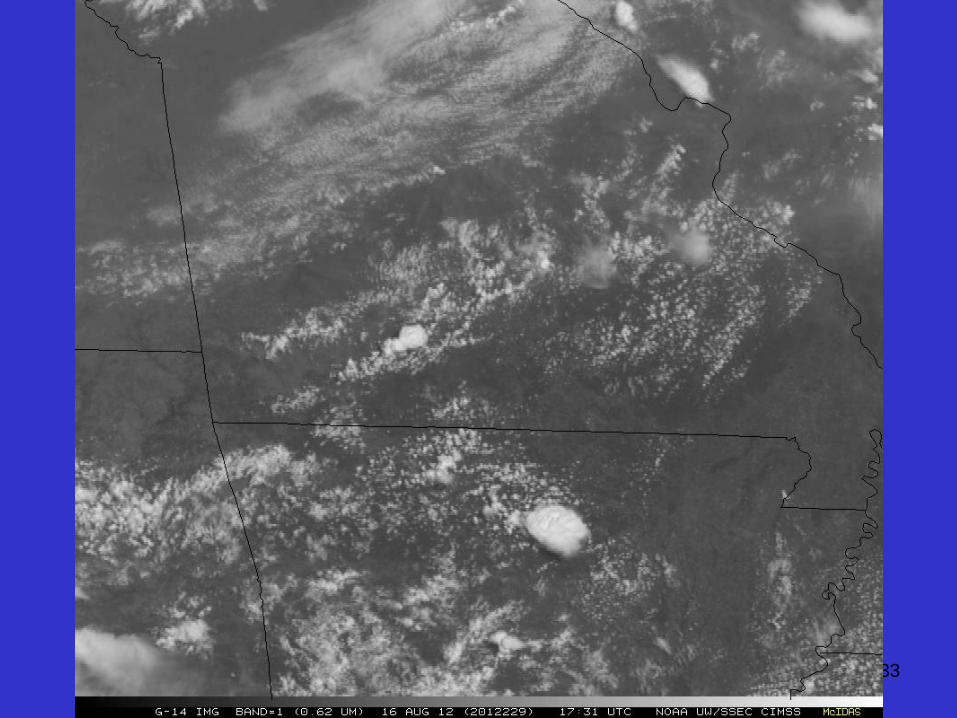
• Reference
• Summary 3
Lockheed Martin
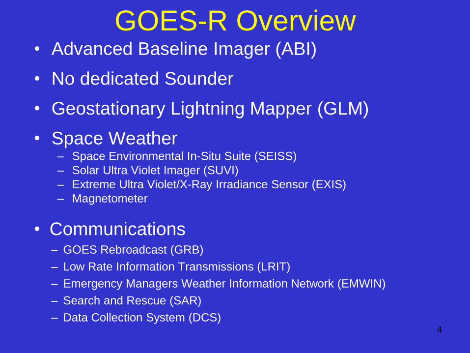
• Advanced Baseline Imager (ABI)
• No dedicated Sounder
• Geostationary Lightning Mapper (GLM)
• Space Weather – Space Environmental In-Situ Suite (SEISS)
– Solar Ultra Violet Imager (SUVI)
– Extreme Ultra Violet/X-Ray Irradiance Sensor (EXIS)
– Magnetometer
• Communications – GOES Rebroadcast (GRB)
– Low Rate Information Transmissions (LRIT)
– Emergency Managers Weather Information Network (EMWIN)
– Search and Rescue (SAR)
– Data Collection System (DCS)
GOES-R Overview
4
5
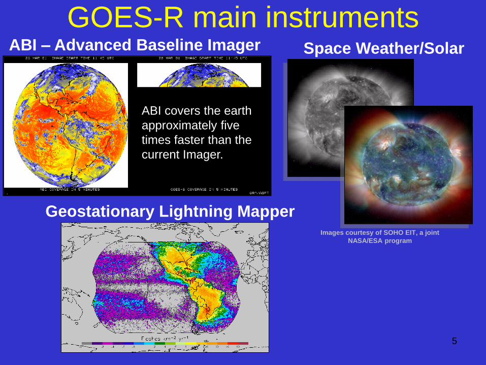
GOES-R main instruments
Images courtesy of SOHO EIT, a joint
NASA/ESA program
Space Weather/Solar
ABI covers the earth
approximately five
times faster than the
current Imager.
ABI – Advanced Baseline Imager
Geostationary Lightning Mapper
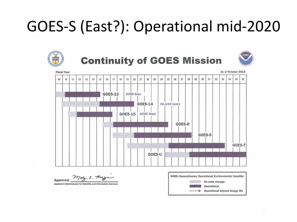
GOES-S (East?): Operational mid-2020
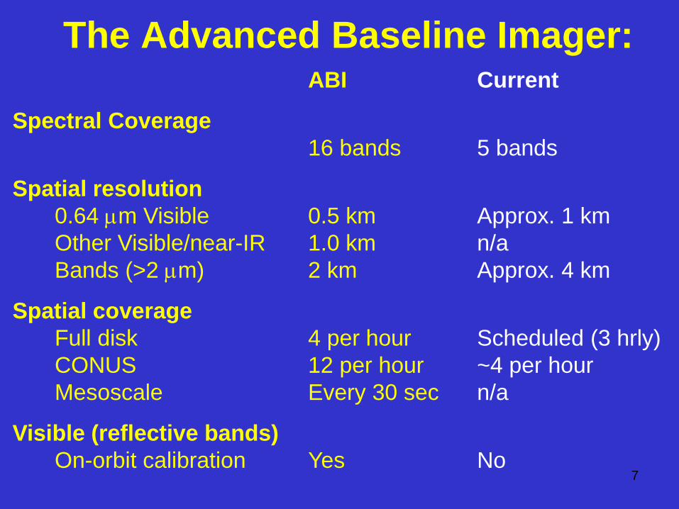
The Advanced Baseline Imager: ABI Current
Spectral Coverage
16 bands 5 bands
Spatial resolution
0.64 mm Visible 0.5 km Approx. 1 km
Other Visible/near-IR 1.0 km n/a
Bands (>2 mm) 2 km Approx. 4 km
Spatial coverage
Full disk 4 per hour Scheduled (3 hrly)
CONUS 12 per hour ~4 per hour
Mesoscale Every 30 sec n/a
Visible (reflective bands)
On-orbit calibration Yes No 7
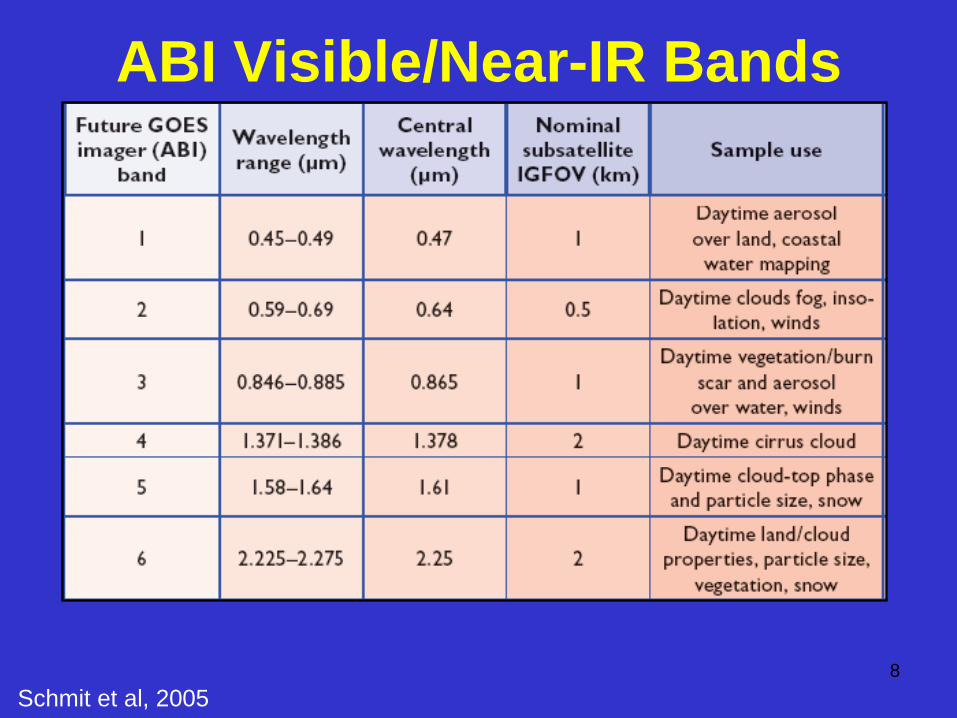
ABI Visible/Near-IR Bands
8
Schmit et al, 2005
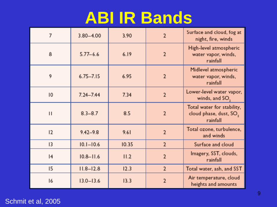
ABI IR Bands
Schmit et al, 2005
9
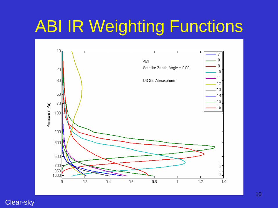
ABI IR Weighting Functions
10
Clear-sky
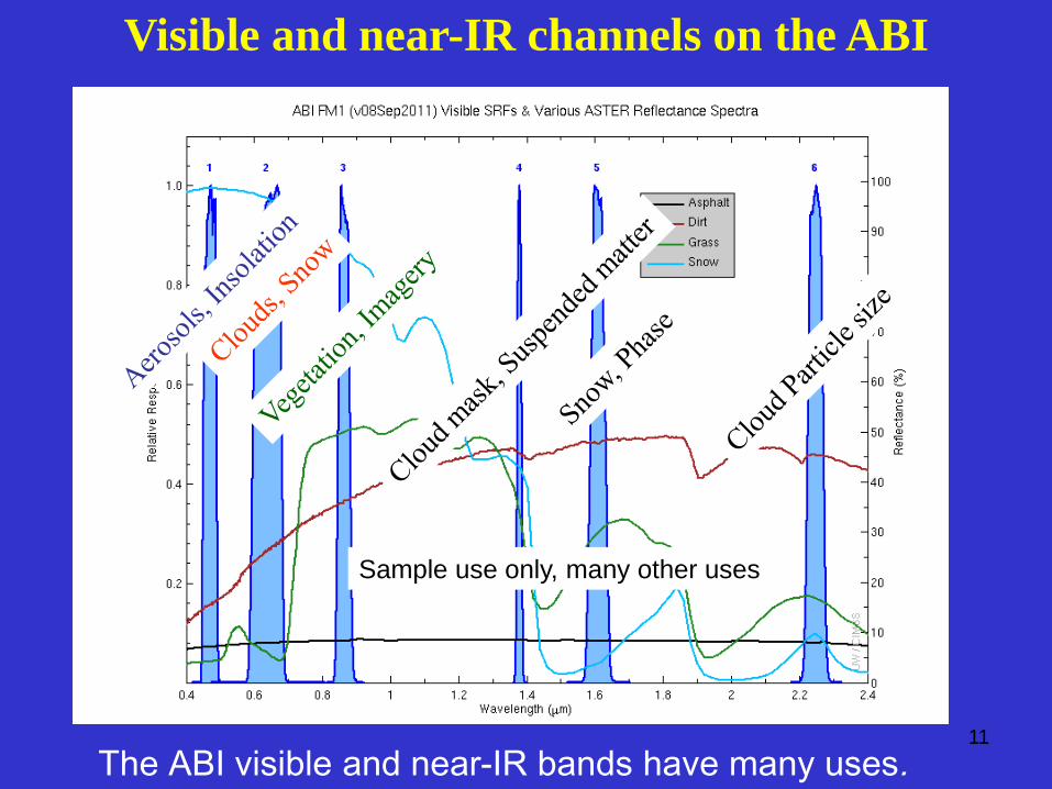
The ABI visible and near-IR bands have many uses. 11
Visible and near-IR channels on the ABI
Sample use only, many other uses
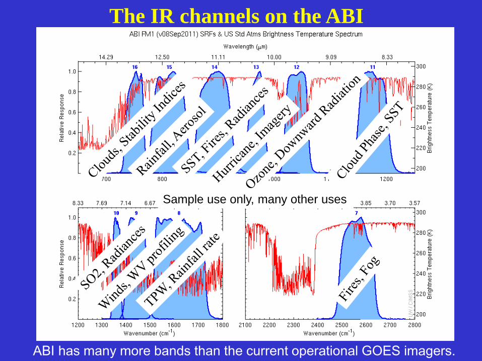
ABI has many more bands than the current operational GOES imagers. 12
The IR channels on the ABI
Sample use only, many other uses
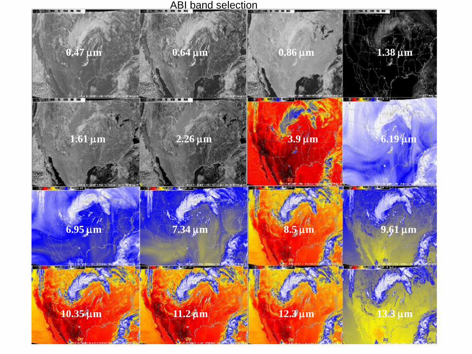
0.64 mm 0.86 mm 1.38 mm
1.61 mm 2.26 mm 3.9 mm 6.19 mm
6.95 mm 7.34 mm
0.47 mm
8.5 mm 9.61 mm
10.35 mm 11.2 mm 12.3 mm 13.3 mm
ABI band selection
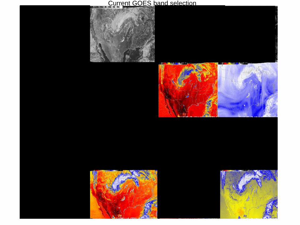
Current GOES band selection
15
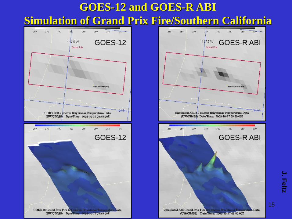
GOES-12 and GOES-R ABI
Simulation of Grand Prix Fire/Southern California
GOES-12
GOES-12
GOES-R ABI
GOES-R ABI
J. F
eltz
16
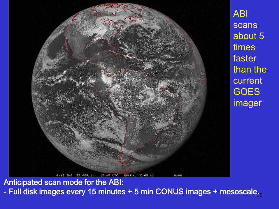
Anticipated scan mode for the ABI:
- Full disk images every 15 minutes + 5 min CONUS images + mesoscale.
ABI
scans
about 5
times
faster
than the
current
GOES
imager
17
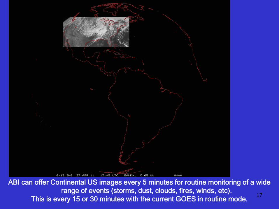
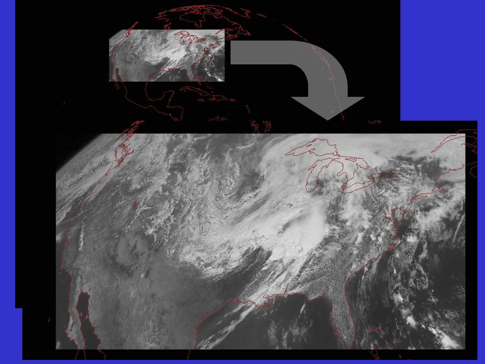
ABI can offer Continental US images every 5 minutes for routine monitoring of a wide
range of events (storms, dust, clouds, fires, winds, etc).
This is every 15 or 30 minutes with the current GOES in routine mode.
18
19
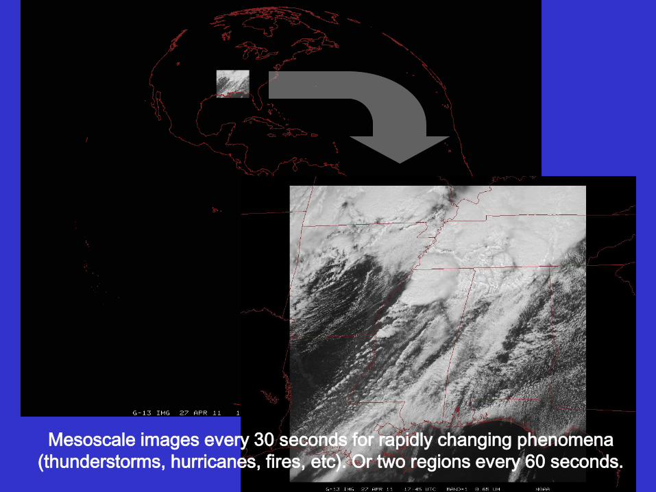
Mesoscale images every 30 seconds for rapidly changing phenomena
(thunderstorms, hurricanes, fires, etc). Or two regions every 60 seconds.

Outline • GOES-R Overview
• GOES-14
– PLT in 2009/2010
– SRSOR (2012 and 2013)
• ABI (Advanced Baseline Imager) Modes
– Flex
– Continuous Full Disk
– Hybrid, etc.
• Other advanced geo images
• GOES-13 Optimized Schedule changes
• Reference
• Summary 20
Lockheed Martin

GOES-14 Science Test December 2009
Don Hillger, Deb Molenar, Dan Lindsey, John Knaff
NOAA/NESDIS/Satellite Applications and Research
Regional And Mesoscale Meteorology Branch (RAMMB)
Dave Watson, Mike Hiatt, Dale Reinke, etc.
CIRA, Colorado State University
Fort Collins CO
Don Hillger and Tim Schmit co-lead the NOAA Science Test
21
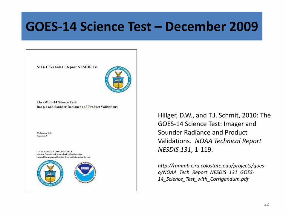
GOES-14 Science Test – December 2009
22
Hillger, D.W., and T.J. Schmit, 2010: The GOES-14 Science Test: Imager and Sounder Radiance and Product Validations. NOAA Technical Report NESDIS 131, 1-119. http://rammb.cira.colostate.edu/projects/goes-o/NOAA_Tech_Report_NESDIS_131_GOES-14_Science_Test_with_Corrigendum.pdf
GOES Science Test Goals For all GOES check-outs, the goals of the Science Test include:
1) To assess the quality of the GOES radiance data. This is accomplished by comparison to other satellite measurements or by calculating the signal-to-noise ratio compared to specifications, as well as assess the striping in the imagery due to multiple detectors.
2) To generate products from the GOES data stream and compare to those produced from other satellites. These included several Imager and Sounder products currently used in operations.
3) Rapid-scan imagery of interesting weather cases are collected with temporal resolutions as fine as every 30 seconds, a capability of rapid-scan imagery from GOES-R that is not implemented operationally on current GOES.
23
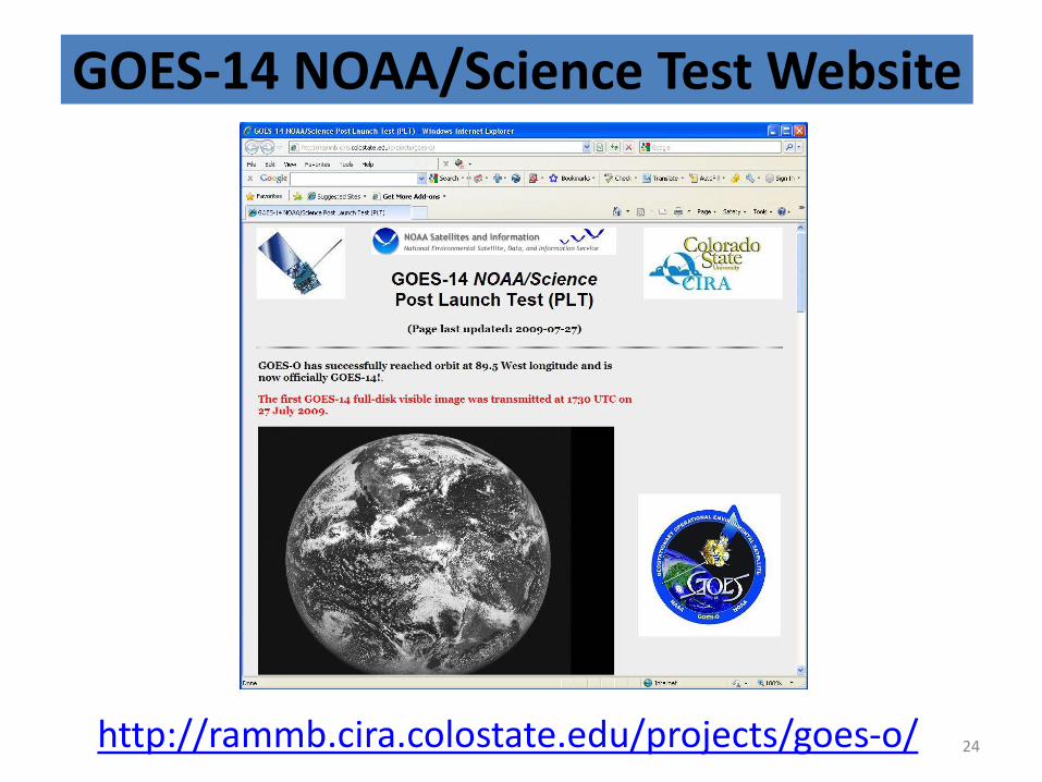
GOES-14 NOAA/Science Test Website
http://rammb.cira.colostate.edu/projects/goes-o/ 24
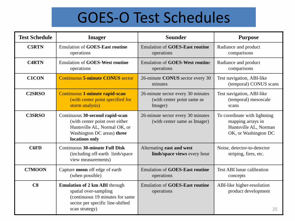
GOES-O Test Schedules Test Schedule Imager Sounder Purpose
C5RTN Emulation of GOES-East routine
operations
Emulation of GOES-East routine
operations
Radiance and product
comparisons
C4RTN Emulation of GOES-West routine
operations
Emulation of GOES-West routine
operations
Radiance and product
comparisons
C1CON Continuous 5-minute CONUS sector 26-minute CONUS sector every 30
minutes
Test navigation, ABI-like
(temporal) CONUS scans
C2SRSO Continuous 1-minute rapid-scan
(with center point specified for
storm analysis)
26-minute sector every 30 minutes
(with center point same as
Imager)
Test navigation, ABI-like
(temporal) mesoscale
scans
C3SRSO Continuous 30-second rapid-scan
(with center point over either
Huntsville AL, Normal OK, or
Washington DC areas) three
locations only
26-minute sector every 30 minutes
(with center same as Imager)
To coordinate with lightning
mapping arrays in
Huntsville AL, Norman
OK, or Washington DC
C6FD Continuous 30-minute Full Disk
(including off-earth limb/space
view measurements)
Alternating east and west
limb/space views every hour
Noise, detector-to-detector
striping, fires, etc.
C7MOON Capture moon off edge of earth
(when possible)
Emulation of GOES-East routine
operations
Test ABI lunar calibration
concepts
C8 Emulation of 2 km ABI through
spatial over-sampling
(continuous 19 minutes for same
sector per specific line-shifted
scan strategy)
Emulation of GOES-East routine
operations
ABI-like higher-resolution
product development
25
“
26
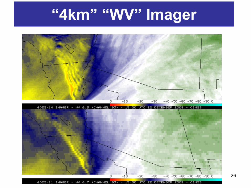
“4km” “WV” Imager
“Water vapor” data from the GOES-14 NOAA Science Test, lead by Hillger and Schmit
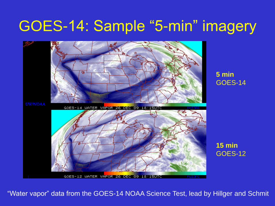
GOES-14: Sample “5-min” imagery
15 min
GOES-12
5 min
GOES-14
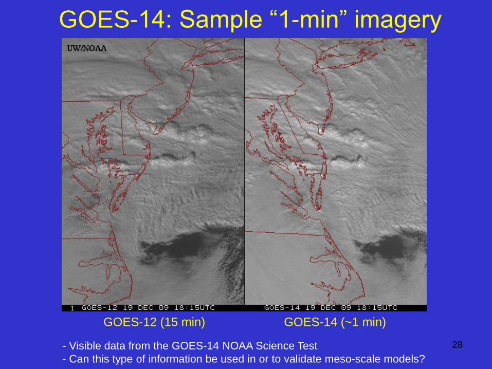
GOES-14: Sample “1-min” imagery
- Visible data from the GOES-14 NOAA Science Test
- Can this type of information be used in or to validate meso-scale models?
GOES-12 (15 min) GOES-14 (~1 min)
28
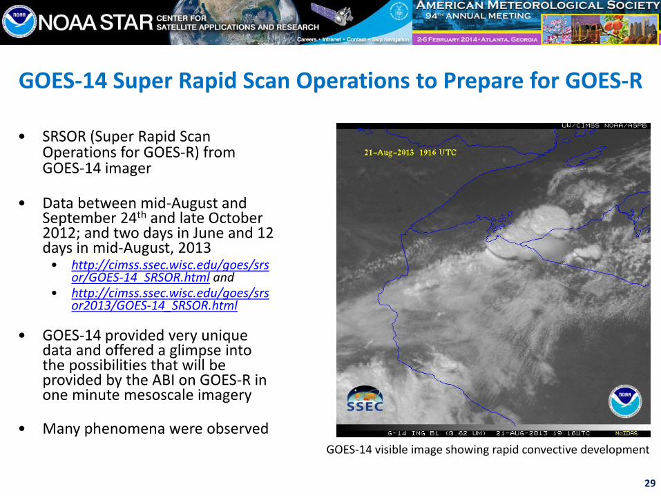
GOES-14 Super Rapid Scan Operations to Prepare for GOES-R
• SRSOR (Super Rapid Scan Operations for GOES-R) from GOES-14 imager
• Data between mid-August and September 24th and late October 2012; and two days in June and 12 days in mid-August, 2013
• http://cimss.ssec.wisc.edu/goes/srsor/GOES-14_SRSOR.html and
• http://cimss.ssec.wisc.edu/goes/srsor2013/GOES-14_SRSOR.html
• GOES-14 provided very unique data and offered a glimpse into the possibilities that will be provided by the ABI on GOES-R in one minute mesoscale imagery
• Many phenomena were observed
29
GOES-14 visible image showing rapid convective development
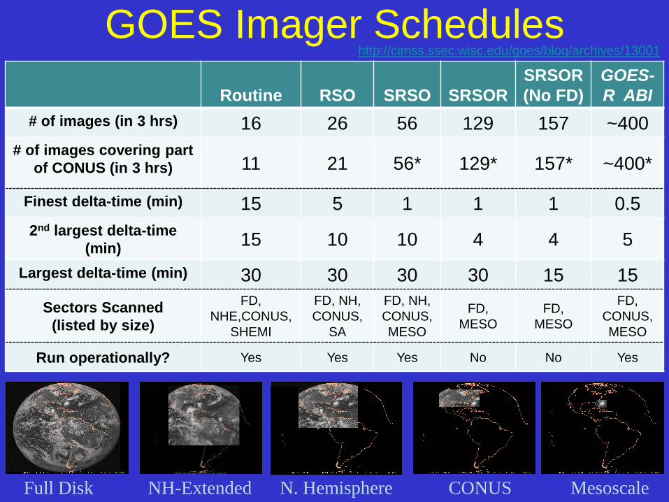
GOES Imager Schedules
Routine RSO SRSO SRSOR
SRSOR
(No FD)
GOES-
R ABI
# of images (in 3 hrs) 16 26 56 129 157 ~400
# of images covering part
of CONUS (in 3 hrs) 11 21 56* 129* 157* ~400*
Finest delta-time (min) 15 5 1 1 1 0.5
2nd largest delta-time
(min) 15 10 10 4 4 5
Largest delta-time (min) 30 30 30 30 15 15
Sectors Scanned
(listed by size)
FD,
NHE,CONUS,
SHEMI
FD, NH,
CONUS,
SA
FD, NH,
CONUS,
MESO
FD,
MESO
FD,
MESO
FD,
CONUS,
MESO
Run operationally? Yes Yes Yes No No Yes
30
Full Disk N. Hemisphere CONUS Mesoscale NH-Extended
http://cimss.ssec.wisc.edu/goes/blog/archives/13001
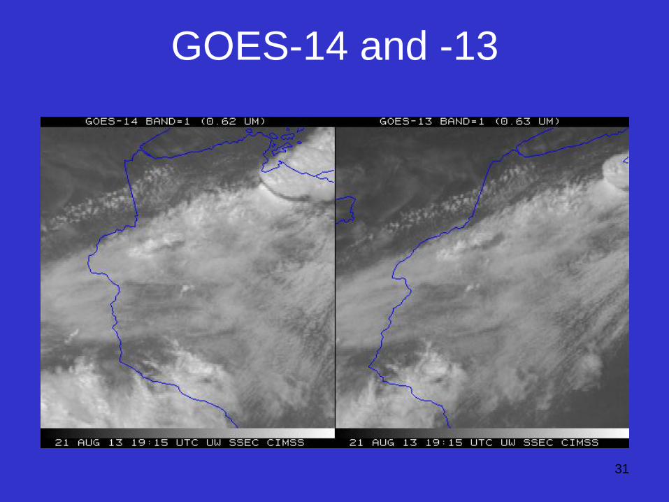
GOES-14 and -13
31

32
Rate of temporal cooling
in the longwave infrared
band
Cintineo et al., 2013 (CIMSS)
33
34
35
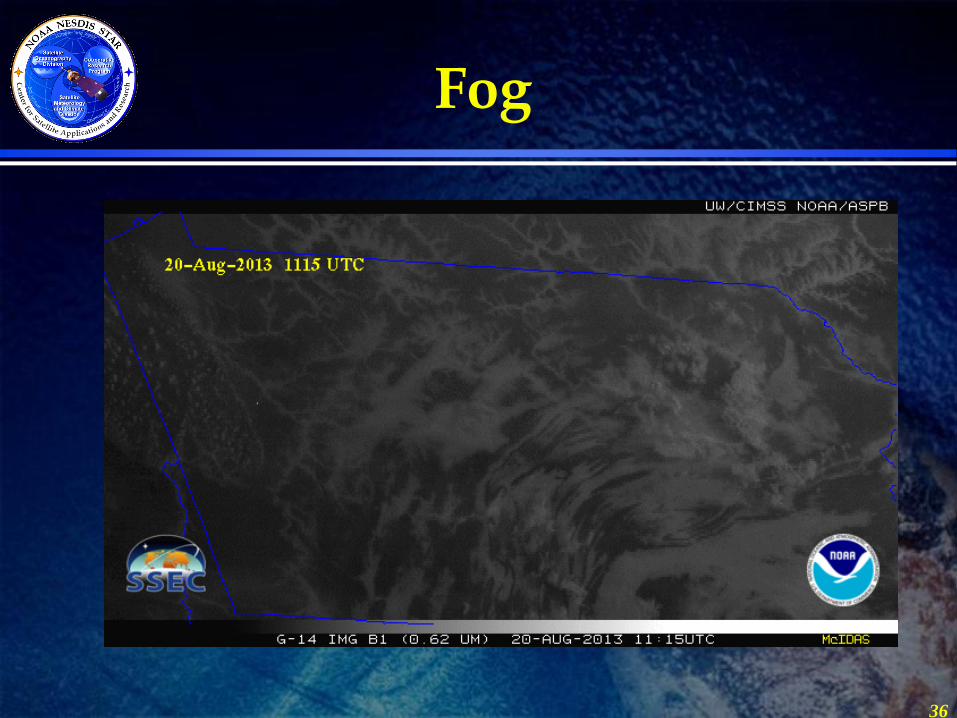
Fog
36
Outline • GOES-R Overview
• GOES-14
– PLT in 2009/2010
– SRSOR (2012 and 2013)
• ABI (Advanced Baseline Imager) Modes
– Flex
– Continuous Full Disk
– Hybrid, etc.
• Other advanced geo images
• GOES-13 Optimized Schedule changes
• Reference
• Summary 37
Lockheed Martin
38
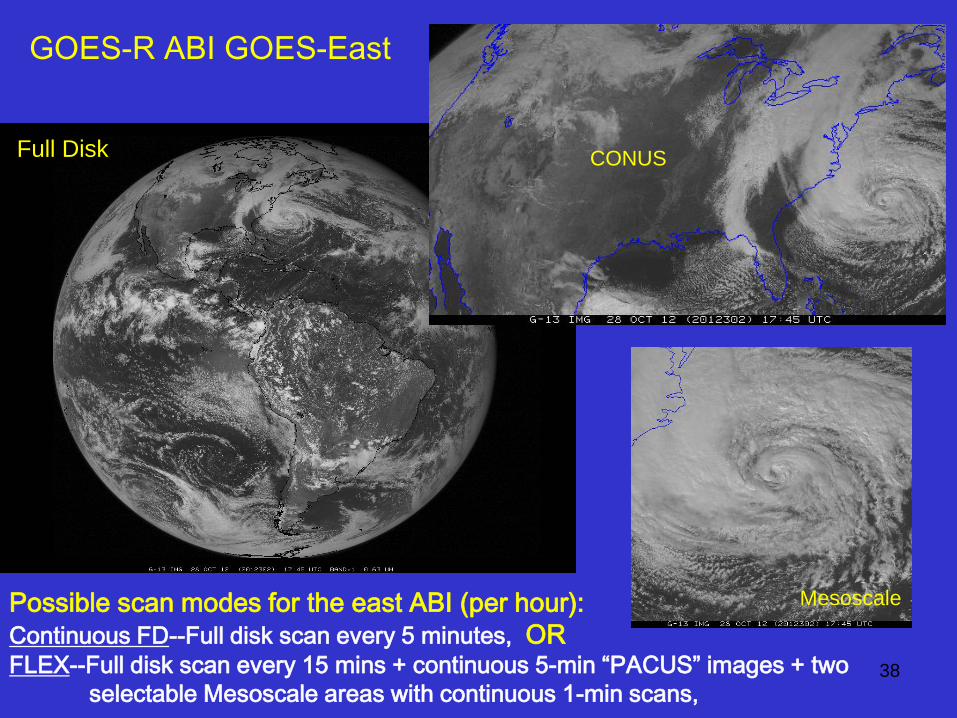
Possible scan modes for the east ABI (per hour):
Continuous FD--Full disk scan every 5 minutes, OR FLEX--Full disk scan every 15 mins + continuous 5-min “PACUS” images + two
selectable Mesoscale areas with continuous 1-min scans,
GOES-R ABI GOES-East
Full Disk
Mesoscale
CONUS
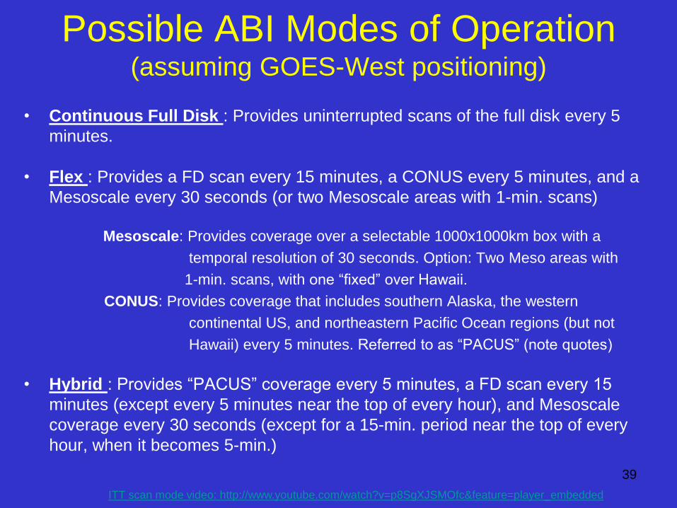
Possible ABI Modes of Operation (assuming GOES-West positioning)
• Continuous Full Disk : Provides uninterrupted scans of the full disk every 5
minutes.
• Flex : Provides a FD scan every 15 minutes, a CONUS every 5 minutes, and a
Mesoscale every 30 seconds (or two Mesoscale areas with 1-min. scans)
Mesoscale: Provides coverage over a selectable 1000x1000km box with a
temporal resolution of 30 seconds. Option: Two Meso areas with
1-min. scans, with one “fixed” over Hawaii.
CONUS: Provides coverage that includes southern Alaska, the western
continental US, and northeastern Pacific Ocean regions (but not
Hawaii) every 5 minutes. Referred to as “PACUS” (note quotes)
• Hybrid : Provides “PACUS” coverage every 5 minutes, a FD scan every 15
minutes (except every 5 minutes near the top of every hour), and Mesoscale
coverage every 30 seconds (except for a 15-min. period near the top of every
hour, when it becomes 5-min.)
39
ITT scan mode video: http://www.youtube.com/watch?v=p8SgXJSMOfc&feature=player_embedded
22-Jan-14
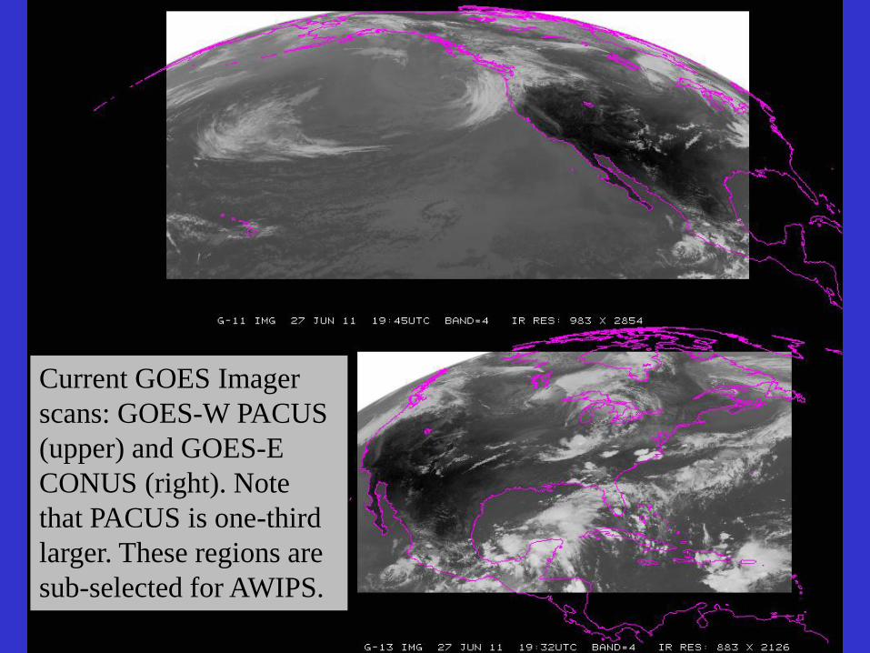
Current GOES Imager
scans: GOES-W PACUS
(upper) and GOES-E
CONUS (right). Note
that PACUS is one-third
larger. These regions are
sub-selected for AWIPS.
41
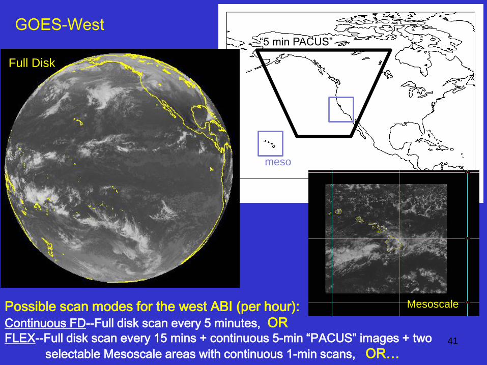
Possible scan modes for the west ABI (per hour):
Continuous FD--Full disk scan every 5 minutes, OR FLEX--Full disk scan every 15 mins + continuous 5-min “PACUS” images + two
selectable Mesoscale areas with continuous 1-min scans, OR…
“5 min PACUS”
meso
GOES-West
Full Disk
Mesoscale
42
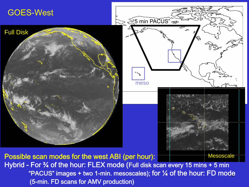
Possible scan modes for the west ABI (per hour):
Hybrid - For ¾ of the hour: FLEX mode (Full disk scan every 15 mins + 5 min
“PACUS” images + two 1-min. mesoscales); for ¼ of the hour: FD mode
(5-min. FD scans for AMV production)
“5 min PACUS”
meso
GOES-West
Full Disk
Mesoscale
44
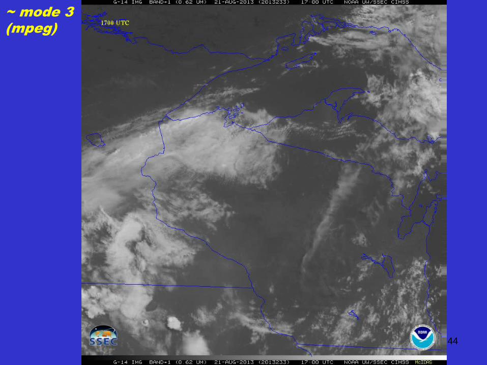
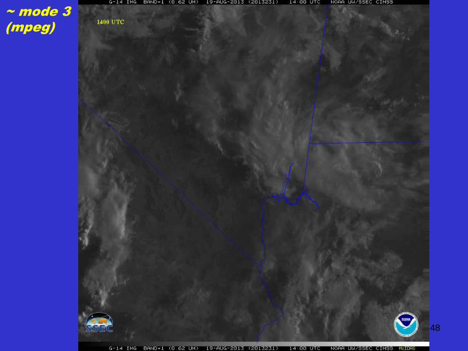
~ mode 3
(mpeg)
46
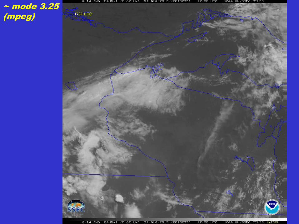
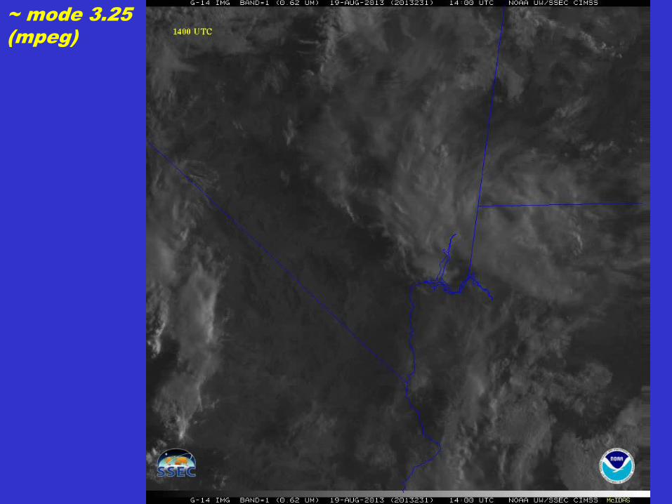
~ mode 3.25
(mpeg)
48
~ mode 3
(mpeg)
50
~ mode 3.25
(mpeg)
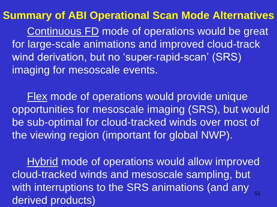
Summary of ABI Operational Scan Mode Alternatives
Continuous FD mode of operations would be great
for large-scale animations and improved cloud-track
wind derivation, but no ‘super-rapid-scan’ (SRS)
imaging for mesoscale events.
Flex mode of operations would provide unique
opportunities for mesoscale imaging (SRS), but would
be sub-optimal for cloud-tracked winds over most of
the viewing region (important for global NWP).
Hybrid mode of operations would allow improved
cloud-tracked winds and mesoscale sampling, but
with interruptions to the SRS animations (and any
derived products) 51
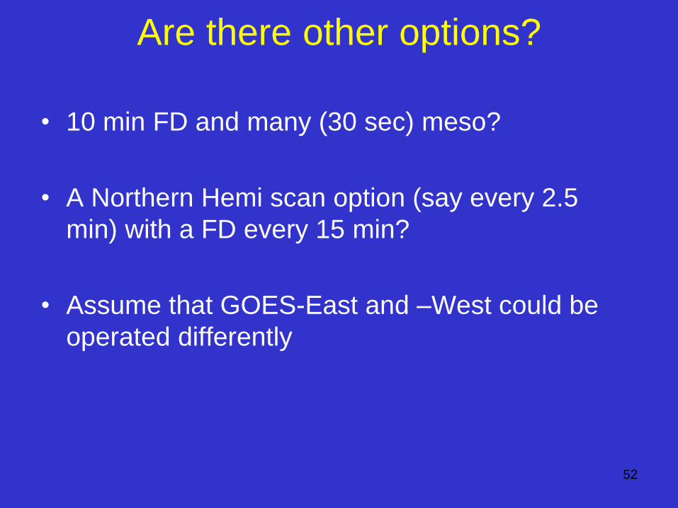
Are there other options?
• 10 min FD and many (30 sec) meso?
• A Northern Hemi scan option (say every 2.5
min) with a FD every 15 min?
• Assume that GOES-East and –West could be
operated differently
52
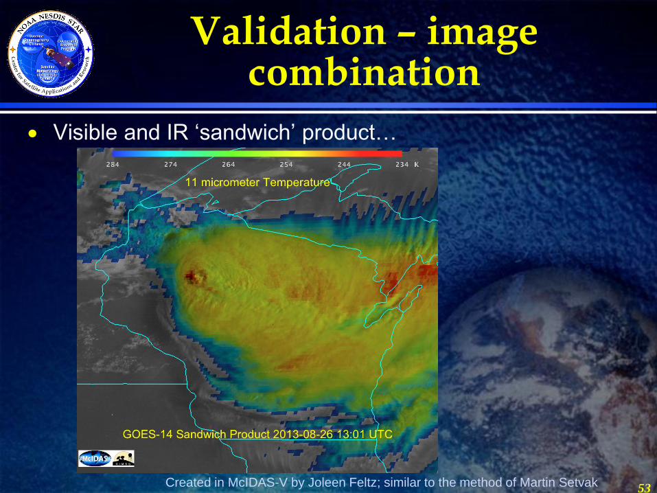
Validation – image combination
Visible and IR ‘sandwich’ product…
53 Created in McIDAS-V by Joleen Feltz; similar to the method of Martin Setvak
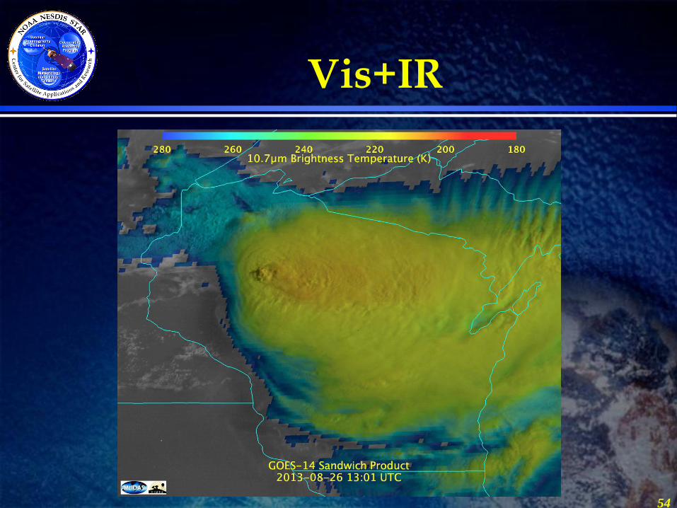
Vis+IR
54
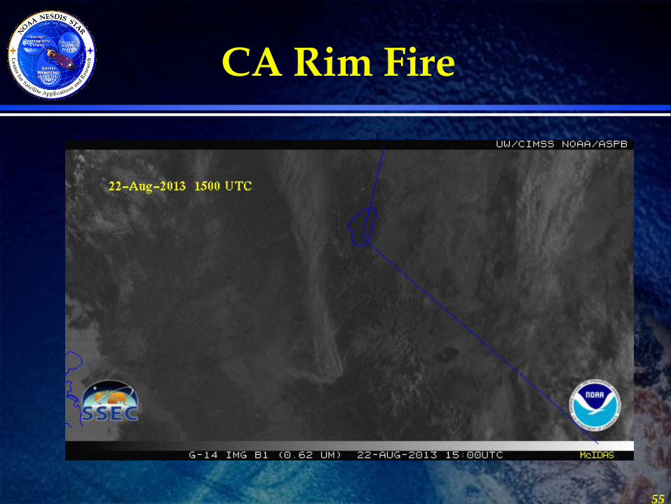
CA Rim Fire
55
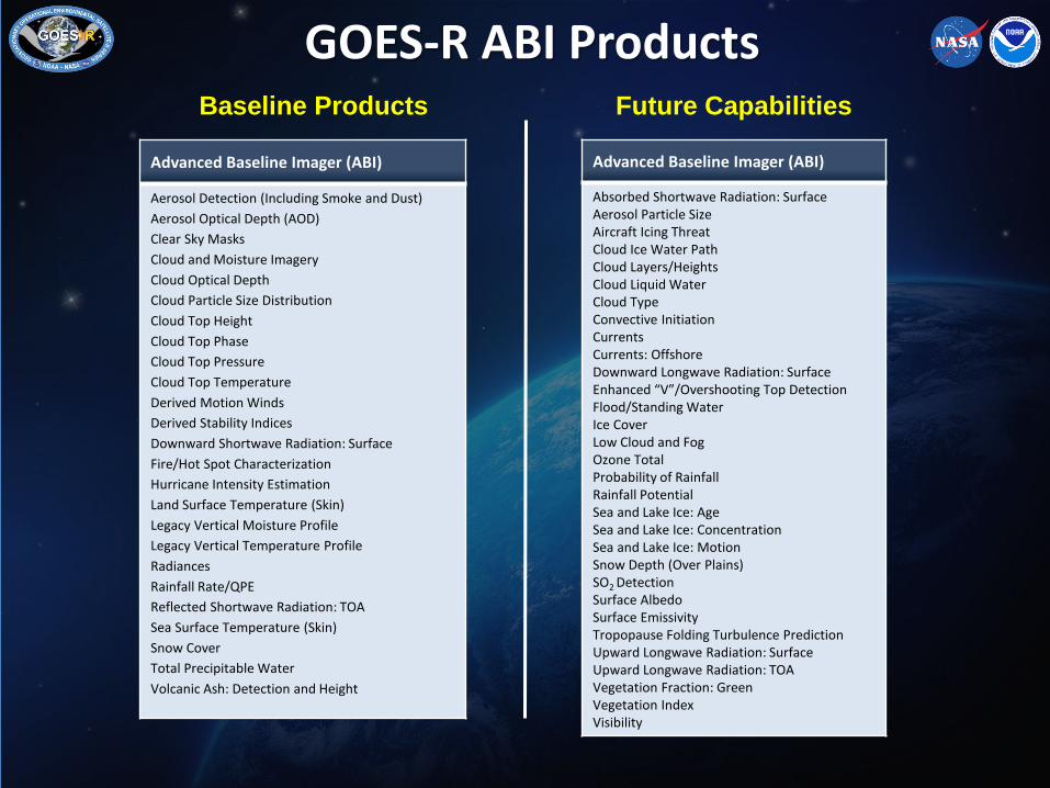
GOES-R ABI Products
Advanced Baseline Imager (ABI)
Aerosol Detection (Including Smoke and Dust)
Aerosol Optical Depth (AOD)
Clear Sky Masks
Cloud and Moisture Imagery
Cloud Optical Depth
Cloud Particle Size Distribution
Cloud Top Height
Cloud Top Phase
Cloud Top Pressure
Cloud Top Temperature
Derived Motion Winds
Derived Stability Indices
Downward Shortwave Radiation: Surface
Fire/Hot Spot Characterization
Hurricane Intensity Estimation
Land Surface Temperature (Skin)
Legacy Vertical Moisture Profile
Legacy Vertical Temperature Profile
Radiances
Rainfall Rate/QPE
Reflected Shortwave Radiation: TOA
Sea Surface Temperature (Skin)
Snow Cover
Total Precipitable Water
Volcanic Ash: Detection and Height
Baseline Products
Advanced Baseline Imager (ABI)
Absorbed Shortwave Radiation: Surface Aerosol Particle Size Aircraft Icing Threat Cloud Ice Water Path Cloud Layers/Heights Cloud Liquid Water Cloud Type Convective Initiation Currents Currents: Offshore Downward Longwave Radiation: Surface Enhanced “V”/Overshooting Top Detection Flood/Standing Water Ice Cover Low Cloud and Fog Ozone Total Probability of Rainfall Rainfall Potential Sea and Lake Ice: Age Sea and Lake Ice: Concentration Sea and Lake Ice: Motion Snow Depth (Over Plains) SO2 Detection Surface Albedo Surface Emissivity Tropopause Folding Turbulence Prediction Upward Longwave Radiation: Surface Upward Longwave Radiation: TOA Vegetation Fraction: Green Vegetation Index Visibility
Future Capabilities
Outline • GOES-R Overview
• GOES-14
– PLT in 2009/2010
– SRSOR (2012 and 2013)
• ABI (Advanced Baseline Imager) Modes
– Flex
– Continuous Full Disk
– Hybrid, etc.
• Other advanced geo images
• GOES-13 Optimized Schedule changes
• Reference
• Summary 57
Fig
ure
court
esy o
f IT
T Industr
ies
Slide: 58
EUM/OPS/VWG/13/717038
Issue 1.0
01 September 2013
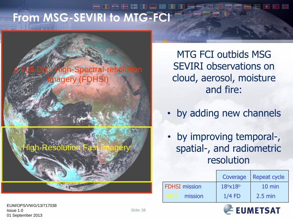
MTG FCI outbids MSG SEVIRI observations on cloud, aerosol, moisture
and fire:
• by adding new channels
• by improving temporal-, spatial-, and radiometric
resolution
High-Resolution Fast Imagery
a Full-Disk High-Spectral-resolution
Imagery (FDHSI)
From MSG-SEVIRI to MTG-FCI
Coverage Repeat cycle
FDHSI mission 18ox18o 10 min
HRFI mission 1/4 FD 2.5 min
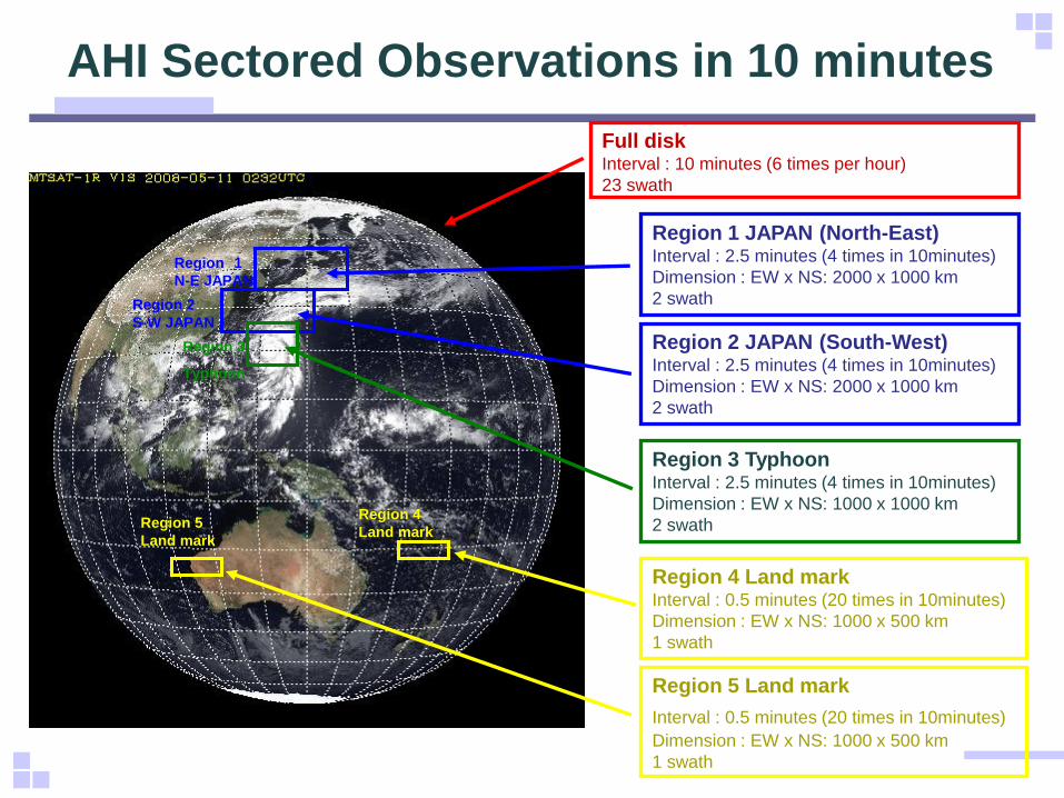
AHI Sectored Observations in 10 minutes
Region 1
N-E JAPAN
Region 2
S-W JAPAN
Region 3
Typhoon
Region 4
Land mark Region 5
Land mark
Full disk Interval : 10 minutes (6 times per hour)
23 swath
Region 1 JAPAN (North-East) Interval : 2.5 minutes (4 times in 10minutes)
Dimension : EW x NS: 2000 x 1000 km
2 swath
Region 2 JAPAN (South-West) Interval : 2.5 minutes (4 times in 10minutes)
Dimension : EW x NS: 2000 x 1000 km
2 swath
Region 3 Typhoon Interval : 2.5 minutes (4 times in 10minutes)
Dimension : EW x NS: 1000 x 1000 km
2 swath
Region 4 Land mark Interval : 0.5 minutes (20 times in 10minutes)
Dimension : EW x NS: 1000 x 500 km
1 swath
Region 5 Land mark
Interval : 0.5 minutes (20 times in 10minutes) Dimension : EW x NS: 1000 x 500 km
1 swath
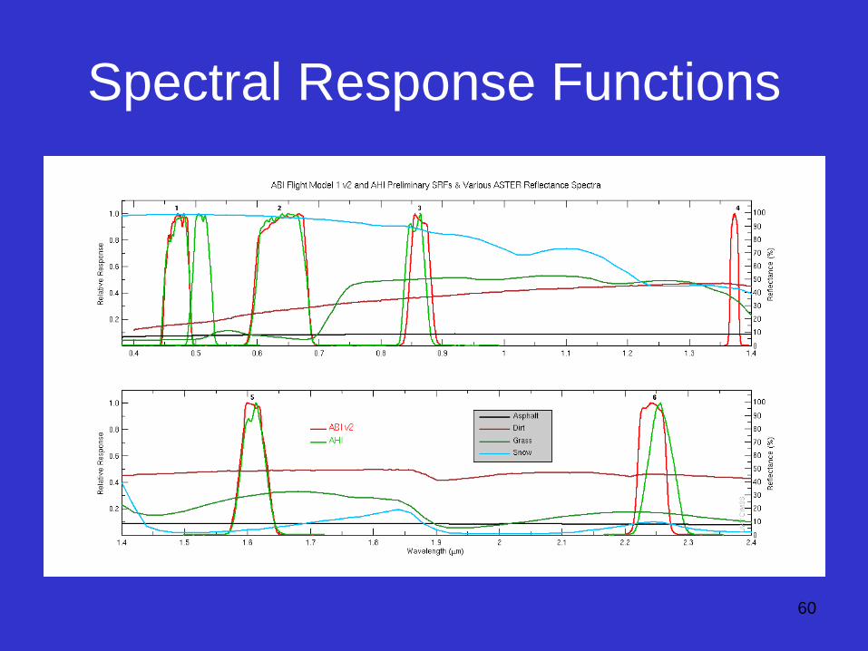
Spectral Response Functions
60
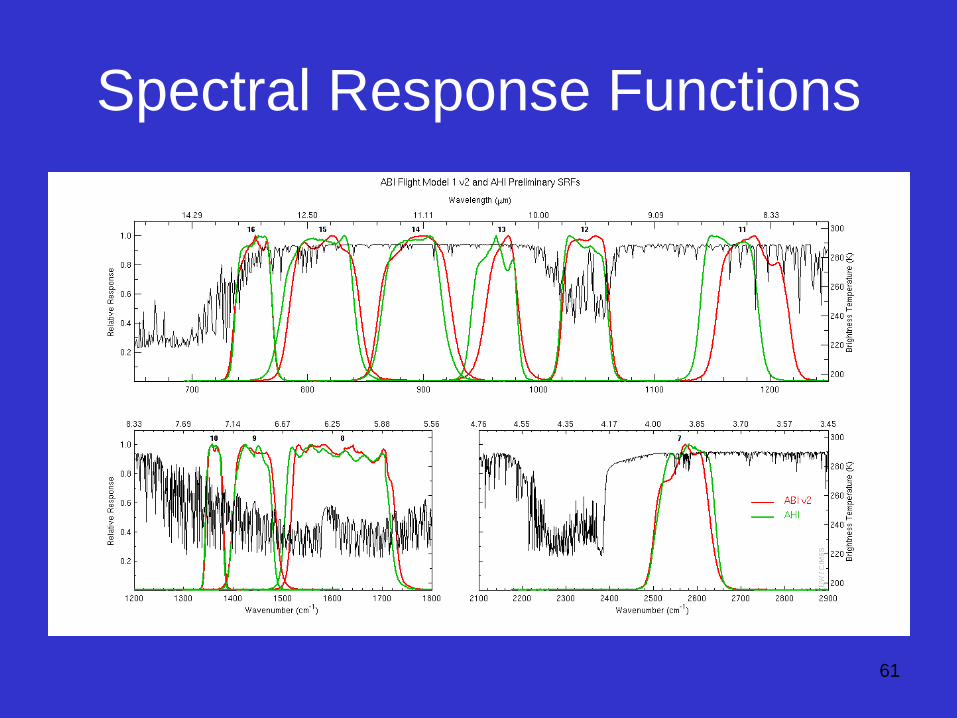
Spectral Response Functions
61
62
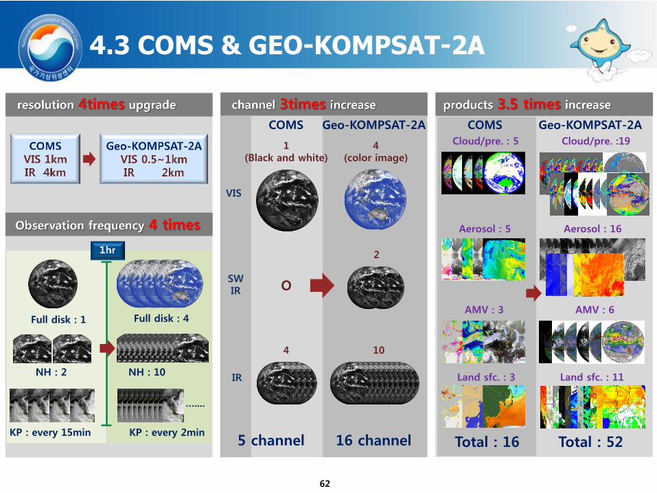
4.3 COMS & GEO-KOMPSAT-2A
COMS
1 (Black and white)
O
4
5 channel
Geo-KOMPSAT-2A
4 (color image)
2
10
16 channel
VIS
SW IR
IR
COMS
Total : 16
Cloud/pre. : 5
Aerosol : 5
AMV : 3
Land sfc. : 3
Geo-KOMPSAT-2A
Total : 52
Cloud/pre. :19
Aerosol : 16
AMV : 6
Land sfc. : 11
Full disk : 1
NH : 2
KP : every 15min
Full disk : 4
NH : 10
…....
KP : every 2min
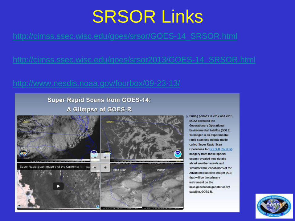
SRSOR Links http://cimss.ssec.wisc.edu/goes/srsor/GOES-14_SRSOR.html
http://cimss.ssec.wisc.edu/goes/srsor2013/GOES-14_SRSOR.html
http://www.nesdis.noaa.gov/fourbox/09-23-13/
63
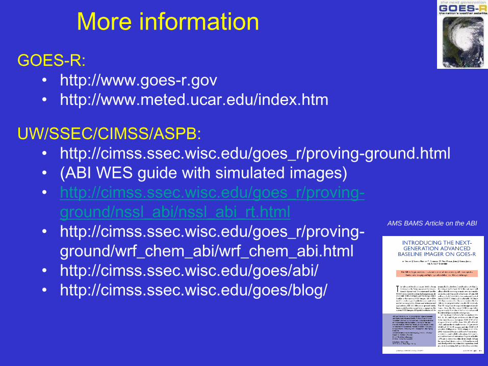
GOES-R:
• http://www.goes-r.gov
• http://www.meted.ucar.edu/index.htm
UW/SSEC/CIMSS/ASPB:
• http://cimss.ssec.wisc.edu/goes_r/proving-ground.html
• (ABI WES guide with simulated images)
• http://cimss.ssec.wisc.edu/goes_r/proving-
ground/nssl_abi/nssl_abi_rt.html
• http://cimss.ssec.wisc.edu/goes_r/proving-
ground/wrf_chem_abi/wrf_chem_abi.html
• http://cimss.ssec.wisc.edu/goes/abi/
• http://cimss.ssec.wisc.edu/goes/blog/
More information
AMS BAMS Article on the ABI
Outline • GOES-R Overview
• GOES-14
– PLT in 2009/2010
– SRSOR (2012 and 2013)
• ABI (Advanced Baseline Imager) Modes
– Flex
– Continuous Full Disk
– Hybrid, etc.
• Other advanced geo images
• GOES-13 Optimized Schedule changes
• Reference
• Summary 65
Exelis
GOES-EAST Optimized Schedules
Kevin Ludlum
NESDIS/OSPO GOES Scheduling (OSPO)
Matthew Seybold, Natalia Donoho
NESDIS/OSPO User Services
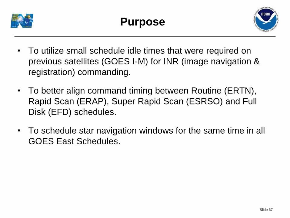
Purpose
• To utilize small schedule idle times that were required on
previous satellites (GOES I-M) for INR (image navigation &
registration) commanding.
• To better align command timing between Routine (ERTN),
Rapid Scan (ERAP), Super Rapid Scan (ESRSO) and Full
Disk (EFD) schedules.
• To schedule star navigation windows for the same time in all
GOES East Schedules.
Slide 67
Slide 68
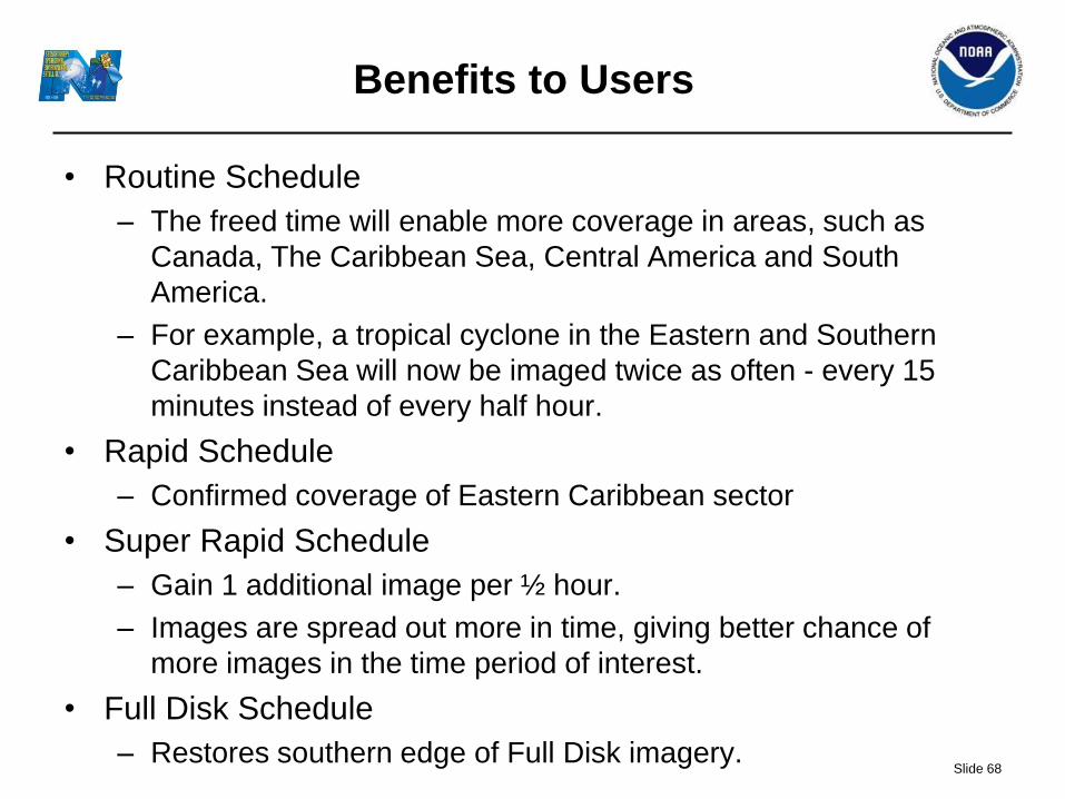
Benefits to Users
• Routine Schedule
– The freed time will enable more coverage in areas, such as
Canada, The Caribbean Sea, Central America and South
America.
– For example, a tropical cyclone in the Eastern and Southern
Caribbean Sea will now be imaged twice as often - every 15
minutes instead of every half hour.
• Rapid Schedule
– Confirmed coverage of Eastern Caribbean sector
• Super Rapid Schedule
– Gain 1 additional image per ½ hour.
– Images are spread out more in time, giving better chance of
more images in the time period of interest.
• Full Disk Schedule
– Restores southern edge of Full Disk imagery.
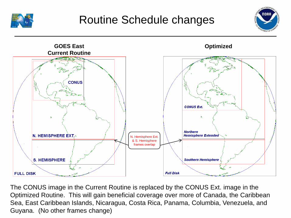
Routine Schedule changes
Optimized GOES East
Current Routine
The CONUS image in the Current Routine is replaced by the CONUS Ext. image in the
Optimized Routine. This will gain beneficial coverage over more of Canada, the Caribbean
Sea, East Caribbean Islands, Nicaragua, Costa Rica, Panama, Columbia, Venezuela, and
Guyana. (No other frames change)
N. Hemisphere Ext.
& S. Hemisphere
frames overlap
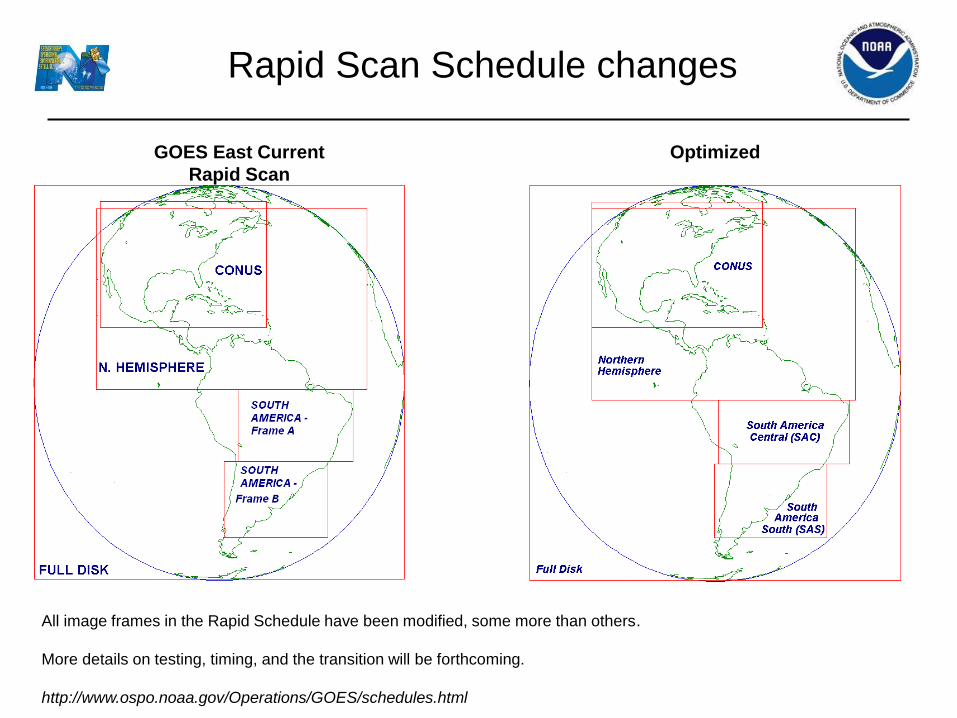
Rapid Scan Schedule changes
Optimized GOES East Current
Rapid Scan
All image frames in the Rapid Schedule have been modified, some more than others.
More details on testing, timing, and the transition will be forthcoming.
http://www.ospo.noaa.gov/Operations/GOES/schedules.html
Outline • GOES-R Overview
• GOES-14
– PLT in 2009/2010
– SRSOR (2012 and 2013)
• ABI (Advanced Baseline Imager) Modes
– Flex
– Continuous Full Disk
– Hybrid, etc.
• Other advanced geo images
• GOES-13 Optimized Schedule changes
• Reference
• Summary 71
Exelis
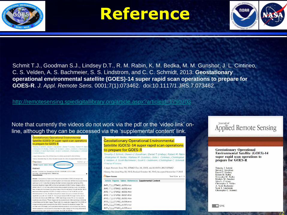
Reference
Schmit T.J., Goodman S.J., Lindsey D.T., R. M. Rabin, K. M. Bedka, M. M. Gunshor, J. L. Cintineo,
C. S. Velden, A. S. Bachmeier, S. S. Lindstrom, and C. C. Schmidt, 2013: Geostationary
operational environmental satellite (GOES)-14 super rapid scan operations to prepare for
GOES-R. J. Appl. Remote Sens. 0001;7(1):073462. doi:10.1117/1.JRS.7.073462.
http://remotesensing.spiedigitallibrary.org/article.aspx?articleid=1790703
72
Note that currently the videos do not work via the pdf or the ‘video link’ on-
line, although they can be accessed via the ‘supplemental content’ link.

Outline • GOES-R Overview
• GOES-14
– PLT in 2009/2010
– SRSOR (2012 and 2013)
• ABI (Advanced Baseline Imager) Modes
– Flex
– Continuous Full Disk
– Hybrid, etc.
• Other advanced geo images
• GOES-13 Optimized Schedule changes
• Reference
• Summary 73
Lockheed Martin
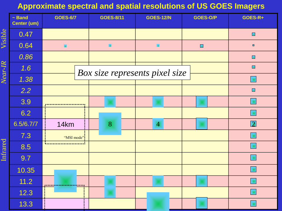
Approximate spectral and spatial resolutions of US GOES Imagers
~ Band
Center (um)
GOES-6/7 GOES-8/11 GOES-12/N GOES-O/P
GOES-R+
0.47
0.64
0.86
1.6
1.38
2.2
3.9
6.2
6.5/6.7/7 14km
7.3
8.5
9.7
10.35
11.2
12.3
13.3
8 4 2
Vis
ible
N
ear-
IR
Infr
ared
Box size represents pixel size
“MSI mode”
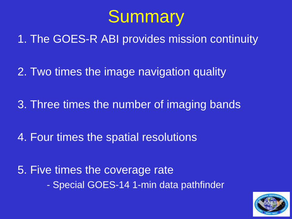
Summary 1. The GOES-R ABI provides mission continuity
2. Two times the image navigation quality
3. Three times the number of imaging bands
4. Four times the spatial resolutions
5. Five times the coverage rate
- Special GOES-14 1-min data pathfinder
75
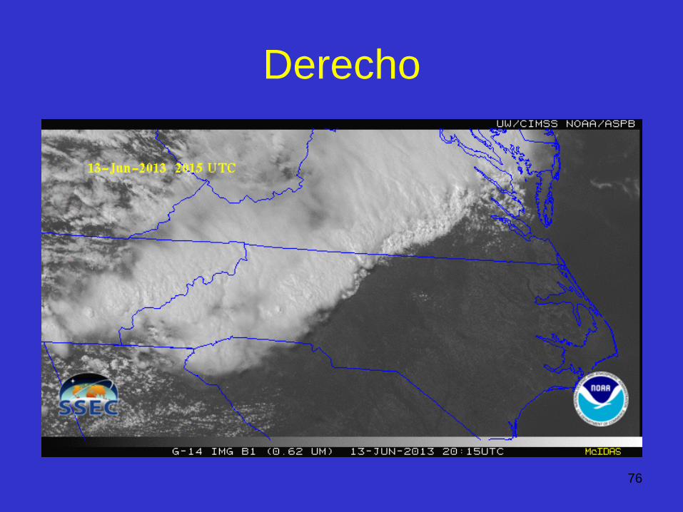
Derecho
76