user’s guide for the clss map browser 2.2 flex versionclss.nrcan.gc.ca/map-carte/clss map browser...
TRANSCRIPT

2
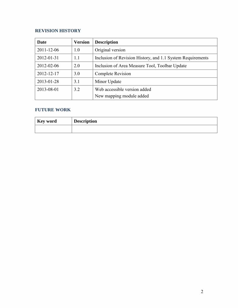
REVISION HISTORY
Date Version Description
2011-12-06 1.0 Original version
2012-01-31 1.1 Inclusion of Revision History, and 1.1 System Requirements
2012-02-06 2.0 Inclusion of Area Measure Tool, Toolbar Update
2012-12-17 3.0 Complete Revision
2013-01-28 3.1 Minor Update
2013-08-01 3.2 Web accessible version added New mapping module added
FUTURE WORK
Key word Description

3
CLSS Map Browser Documentation 1 Home Page of CLSS Map Browser ................................................................................. 5
1.1 System Requirements................................................................................................ 5 2 The six core elements....................................................................................................... 7
2.1 Tools toolbar ............................................................................................................. 7 2.2 Navigation slider ....................................................................................................... 7 2.3 North arrow box ........................................................................................................ 7 2.4 Scale bar .................................................................................................................... 7 2.5 Selection(s) ............................................................................................................... 8
2.5.1 Select by Attribute ............................................................................................. 8 2.5.2 Select by Location.............................................................................................. 8
2.6 Results ....................................................................................................................... 8 2.6.1 Results after selection by attribute ..................................................................... 8 2.6.2 Results after selection by location ..................................................................... 8
3.1 Re-initializing interface .......................................................................................... 12 3.2 Plan searches ........................................................................................................... 12 3.3 Repositioning Dialog Boxes ................................................................................... 13
3.3.1 Minimize Dialog Boxes ................................................................................... 13 3.3.2 Repositioning Results Box ............................................................................... 14 3.3.3 Adjusting Dialog Boxes ................................................................................... 16
4 Search examples............................................................................................................. 17 Clearing Dropdown Box Entries ............................................................................... 17
4.1 Indian Reserve Searches ......................................................................................... 18 4.1.1 Indian Reserve Search by Name ...................................................................... 18 4.1.2 Indian Reserve Search by First Nation ............................................................ 19
4.2 National Park Searches ........................................................................................... 21 4.3 Parcel Searches ....................................................................................................... 22
4.3.1 Parcel Search by Canada Land ........................................................................ 22 4.3.2 Parcel Search by Parcel Designator ................................................................. 23 4.3.3 Parcel Search by Plan ....................................................................................... 24 4.3.4 Parcel Search by Township .............................................................................. 26 4.4.1 Survey Plan by Canada Land ........................................................................... 27 4.4.2 Survey Plan by Plan (Alternate Plan) .............................................................. 28 4.4.3 Survey Plan by Alternate Plan ......................................................................... 29
4.5 Surveys in Progress Searches.................................................................................. 31 4.5.1 Surveys in Progress by Project Number .......................................................... 31 4.6.1 Municipal Boundary by Name ......................................................................... 33 4.7.1 Township by Legal Description ....................................................................... 34
4.8 Protected Areas Searches ........................................................................................ 36 4.8.1 Protected Area by Name .................................................................................. 36
4.9 Community Searches .............................................................................................. 37 4.9.1 Community by Name ....................................................................................... 37
4.10 Subdivision Searches ............................................................................................ 38 4.10.1 Subdivision by Name ..................................................................................... 38

4
4.11 Quad Searches ....................................................................................................... 39 4.11.1 Quad by Name ............................................................................................... 39 4.12.1 Cree Naskapi by Name .................................................................................. 40
5 Navigator toolbar ........................................................................................................... 41 5.1 Zoom all .................................................................................................................. 41 5.2 Zoom in ................................................................................................................... 41 5.3 Zoom out ................................................................................................................. 41 5.4 Pan........................................................................................................................... 41 5.5 Zoom previous ........................................................................................................ 41 5.6 Zoom next ............................................................................................................... 41 5.7.1 Select by Rectangle .............................................................................................. 41 5.7.2 Select by Polygon ................................................................................................ 41 5.8.1 Measure Length ................................................................................................... 42 5.8.2 Measure Area ....................................................................................................... 42 5.9 Print ......................................................................................................................... 42 5.10 Legend................................................................................................................... 43 5.11 Info ........................................................................................................................ 43 5.12 Help ....................................................................................................................... 43
Appendix - Testing schema .............................................................................................. 44 A1 Region / Attribute query cross-reference table ....................................................... 44 A2 Region – Layer cross-reference table...................................................................... 45
5
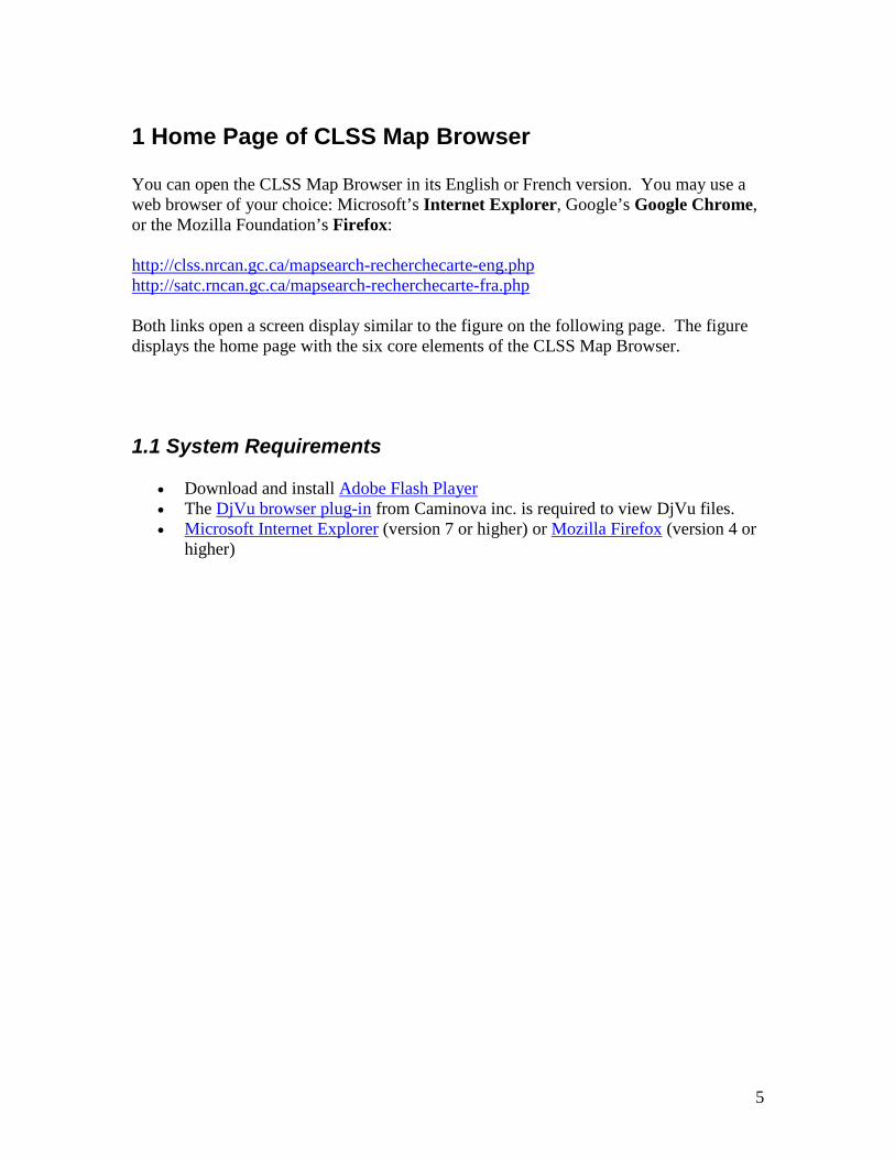
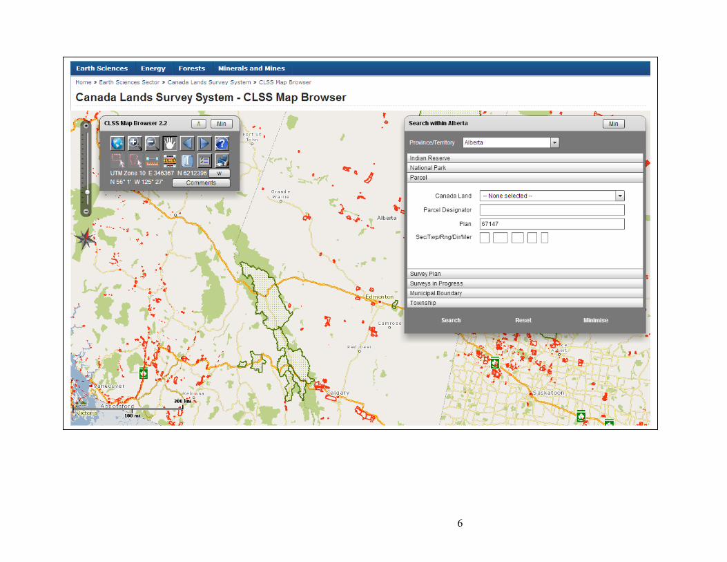
1 Home Page of CLSS Map Browser You can open the CLSS Map Browser in its English or French version. You may use a web browser of your choice: Microsoft’s Internet Explorer, Google’s Google Chrome, or the Mozilla Foundation’s Firefox: http://clss.nrcan.gc.ca/mapsearch-recherchecarte-eng.php http://satc.rncan.gc.ca/mapsearch-recherchecarte-fra.php Both links open a screen display similar to the figure on the following page. The figure displays the home page with the six core elements of the CLSS Map Browser.
1.1 System Requirements
• Download and install Adobe Flash Player • The DjVu browser plug-in from Caminova inc. is required to view DjVu files. • Microsoft Internet Explorer (version 7 or higher) or Mozilla Firefox (version 4 or
higher)
6

7
2 The six core elements
2.1 Tools toolbar The Tools Toolbar includes 14 tools. It also displays the current mouse position in latitude/longitude and UMT Easting/Northing values at the bottom. Details on each individual tool are provided in section 5.
2.2 Navigation slider The Navigation Slider lets users zoom to different scale levels. You can click on slider tick marks instead of pointing to a new increment to determine the scale of the current screen view. You can click any increment to reposition the slider tick marks thereby zooming in or zooming out to a specific scale. The operation is identical to the zoom in and out tools in the Navigation toolbar.
2.3 North arrow box The North Arrow Box indicates where Geographic North is with respect to the center of the current screen view. The WMB displays all features in a Lambert Conformal Conic map projection to best accommodate display of the entire country. The North Arrow Box may help you to orient yourself.
2.4 Scale bar A Scale Bar is displayed in the lower left of the view screen to you to appreciate the relative size of map features.

8
2.5 Selection(s)
2.5.1 Select by Attribute The Search Box permits you to query the underlying GIS database using specific attribute values. For example, you could search for parcels within Alberta specifying a parcel designator value. You can issue attribute queries using a full attribute term or only a part thereof. And you can narrow the search criteria by entering values in multiple text boxes and/or choosing from dropdown menus.
2.5.2 Select by Location You can also select features using the mouse pointer. You can select interactively by either defining a rectangle or polygon on screen location. The selection will drill down meaning that multiple database layers are searched at the specified location – an advantage over the Select by Attribute selection.
2.6 Results You can hover over records listed in the results box and the corresponding feature in the map will be highlighted.
2.6.1 Results after selection by attribute The Results Box displays the selected features. It displays features by the category they were queried by. For example, querying the parcels using the Search Box will result in entries related to the parcels layer, hence the title Parcels (37) of the Results Box. The number after the category in parenthesis lists the number of selected features.
2.6.2 Results after selection by location The results box is slightly different after interactively selecting features using the Select tools; remember that you may specify either a rectangle or polygon; both actions search multiple layers at the respective location which offers an obvious advantage over using the Select by Attribute tool.

9
Information on the following three tabbed categories are returned if present: Survey Plans, Parcels and Surveys in progress. Each category in turn includes multiple pieces of information on all the selected features. The information is presented in columns with some categories including more columns than others.
Three columns allow feature highlighting and zooming: Parcel designator, Plan number, and Project number. Whenever you hover over a particular cell value in one of the three columns, then the corresponding feature is highlighted in red on-screen. Click the particular cell value, and the screen will be positioned on the corresponding feature zooming to it.

10
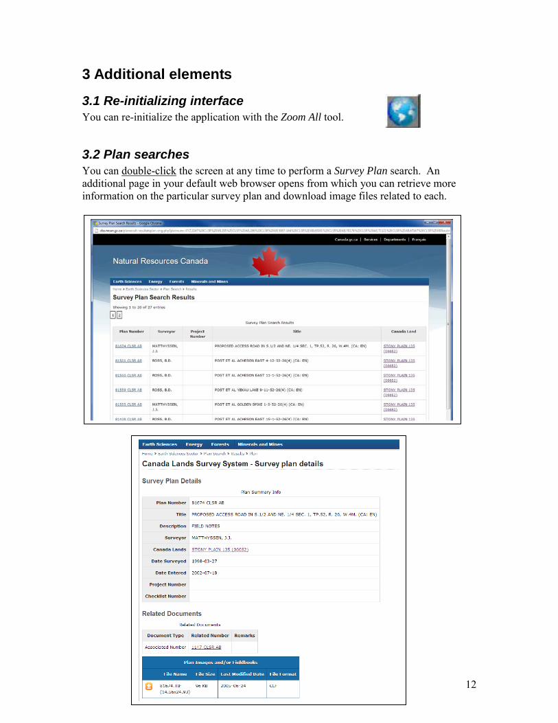
In addition, you can click on the Hyperlink in the last column under each category to open another web page with further information. A new web page will open similar to the one shown below with detailed information on a selected survey plan or project.

11
In addition, you can click the Export table button to export the currently listed information to a CSV file.
12
3 Additional elements
3.1 Re-initializing interface You can re-initialize the application with the Zoom All tool.
3.2 Plan searches You can double-click the screen at any time to perform a Survey Plan search. An additional page in your default web browser opens from which you can retrieve more information on the particular survey plan and download image files related to each.

13
3.3 Repositioning Dialog Boxes The available display area of the application varies among hardware pieces: For example, desktop computers usually provide more area than laptops. You can minimize, adjust and reposition dialog boxes to increase the visible area of the application.
3.3.1 Minimize Dialog Boxes Click the Min (Minimise) button to collapse the main toolbox, the Search box or the Results box as shown in the figures below; expanded dialog boxes are shown first, followed by the minimised or collapsed view of the dialog boxes.

14
3.3.2 Repositioning Results Box You can reposition the Results box from the upper right to the lower left of the application window by clicking the “Lower left” button as shown in the next and following figures.

15
After clicking the “Lower left” button, the Results box is positioned in the lower left of the display window.

16
3.3.3 Adjusting Dialog Boxes You can also adjust the height of the Search and Results dialog boxes when clicking the “Adjust” button. After clicking the “Adjust” button its icon changes from an up arrow to a down arrow. The button is located in the Toolbox as it is a global setting. The height of all dialog boxes will be affected. For example, the two figures below illustrate how the height of the Search dialog box will be reduced after clicking the “Adjust” button.

17
4 Search examples To navigate to a particular province, for example Alberta, use the Province/Territory dropdown menu in the top of the Search box. Choose Alberta and the screen view will be repositioned to center on Alberta. Alternately, you can use the navigation tools to zoom/pan to a location of interest. The title of the Search box indicates which jurisdiction you operate in, for example, Search Within AB. Jurisdictions include different search categories; the three territories, for example, include a Quad category, while the prairie-provinces include a Township category. Refer to section 6.1 for a complete listing of which categories are available for what jurisdiction. Generally, you can enter the complete text of the item you search for, parts thereof or no text at all. The search tool automatically appends wildcard characters to the beginning and end of each search text. For example, you can enter the full name of the Indian Reserve “STONY PLAIN 135”, or you can just enter “STONY” while zoomed in to the province of Alberta. The first search text results in a single record, while the second results in two records because it matches two reserve names: “STONY PLAIN 135” and “STONY PLAN 135A”. You can enter lower or upper case text, however, the correct spelling of text is important. In addition, you can enter text in multiple text boxes. Though, observe that they narrow the search; all search items must match at the same time to produce a result. Empty or blank searches might take long times as larger search results will be created. Searches are triggered when you press the ENTER key or click the Search button in the lower left of the Search box. Either operation immediately collapses the Search box freeing up screen space to display the Results box instead of the Search box. You can reopen the Search box by clicking the Close button in the Results box.
Clearing Dropdown Box Entries All dropdown menu choices can be cleared either by clicking the Reset button, or simply typing a space. Clicking the Reset button reinitializes the entire Search box.

18
4.1 Indian Reserve Searches You can search Indian Reserves by Name and/or First Nation. You can enter the full name of an Indian Reserve, parts thereof or none. You can also select a First Nation from the dropdown box. You can also provide both search criteria in which case only Indian Reserves that match both criteria will be retrieved.
4.1.1 Indian Reserve Search by Name Example: Enter the text “stony” in the Name textbox while zoomed to the province of Alberta and press the ENTER key OR click the Search button at the bottom of the Search box. The Search box collapses and the Results box opens displaying the number of matching Indian Reserves found (“Indian reserve (2)”) and the list of all Indian Reserves names retrieved (“STONY PLAIN 135” and “STONY PLAIN 135A”).

19
4.1.2 Indian Reserve Search by First Nation Example: Alternatively, you could select “ENOCH CREE NATION #440” from the First Nation dropdown box and click the Search button at the bottom of the Search box.
The Search box collapses and the Results box opens displaying the number of matching Indian Reserves found (“Indian reserve (2)”) and the list of all Indian Reserves names retrieved (“STONY PLAIN 135” and “STONY PLAIN 135A”.

20
Graphical result of example search.
21
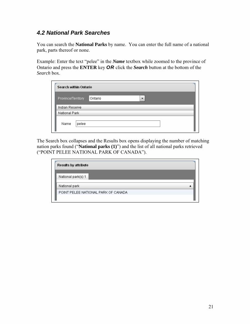
4.2 National Park Searches You can search the National Parks by name. You can enter the full name of a national park, parts thereof or none. Example: Enter the text “pelee” in the Name textbox while zoomed to the province of Ontario and press the ENTER key OR click the Search button at the bottom of the Search box. The Search box collapses and the Results box opens displaying the number of matching nation parks found (“National parks (1)”) and the list of all national parks retrieved (“POINT PELEE NATIONAL PARK OF CANADA”).

22
4.3 Parcel Searches You can search Parcels by Canada Land, Parcel Designator, Plan and/or Township elements. You can enter the complete designation of parcels, its complete plan number, elements of a township designation, parts of any of the aforementioned or none. You can also select a Canada Land name from the dropdown box. You can provide information in multiple entries limiting search as all criteria must match the desired result set.
4.3.1 Parcel Search by Canada Land Example: You can select “PEGUIS 1B” from the Canada Land dropdown box while zoomed the province of Manitoba and click the Search button at the bottom of the Search box. The Search box collapses and the Results box opens displaying the number of matching Parcels found (“Parcel (1489)”) and the list of all parcels retrieved by Parcel designator and Plan number.

23
4.3.2 Parcel Search by Parcel Designator Example: Enter the text “lot 10” in the Parcel Designator textbox while zoomed to the province of Manitoba and press the ENTER key OR click the Search button at the bottom of the Search box. The Search box collapses and the Results box opens displaying the number of matching Parcels found (“Parcel (199)”) and the list of all parcels retrieved by Parcel designator and Plan number.

24
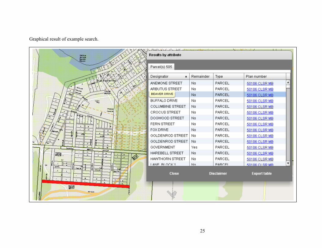
4.3.3 Parcel Search by Plan Example: Enter the text “50106” in the Plan textbox while zoomed to the province of Manitoba and press the ENTER key OR click the Search button at the bottom of the Search box. The Search box collapses and the Results box opens displaying the number of matching Parcels found (“Parcel (505)”) and the list of all parcels retrieved by Parcel designator and Plan number.
25
Graphical result of example search.
26
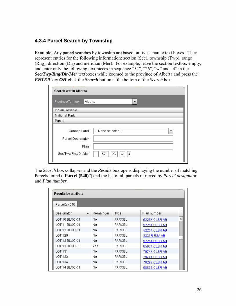
4.3.4 Parcel Search by Township Example: Any parcel searches by township are based on five separate text boxes. They represent entries for the following information: section (Sec), township (Twp), range (Rng), direction (Dir) and meridian (Mer). For example, leave the section textbox empty, and enter only the following text pieces in sequence “52”, “26”, “w” and “4” in the Sec/Twp/Rng/Dir/Mer textboxes while zoomed to the province of Alberta and press the ENTER key OR click the Search button at the bottom of the Search box. The Search box collapses and the Results box opens displaying the number of matching Parcels found (“Parcel (540)”) and the list of all parcels retrieved by Parcel designator and Plan number.

27
4.4 Survey Plan Searches You can search Survey Plans by Canada Land, Plan and/or Alternate Plan. You can enter a complete plan number or alternate plan number, parts thereof or none. You can also select a Canada Land name from the dropdown box. You can also provide both search criteria in which case only survey plans that match both criteria will be retrieved.
4.4.1 Survey Plan by Canada Land Example: You can select “WOODSTOCK INDIAN RESERVE NO. 23” from the Canada Land dropdown box while zoomed to the province of New Brunswick and click the Search button at the bottom of the Search box. The Search box collapses and the Results box opens displaying the number of matching Survey plans found (“Survey plan (84)”) and the list of all parcels retrieved by Plan number, Description, Date of survey and Surveyor.

28
4.4.2 Survey Plan by Plan (Alternate Plan) Example: Enter the text “58426” in the Plan textbox while zoomed to the province of New Brunswick and press the ENTER key OR click the Search button at the bottom of the Search box. The Search box collapses and the Results box opens displaying the number of matching Survey plans found (“Survey plan (1)”) and the list of all parcels retrieved by Plan number, Description, Date of survey and Surveyor.

29
4.4.3 Survey Plan by Alternate Plan Example: Enter the text “96-01” in the LTO# textbox while zoomed to the Yukon Territories and press the ENTER key OR click the Search button at the bottom of the Search box. The Search box collapses and the Results box opens displaying the number of matching Survey plans found (“Survey plan (1)”) and the list of all parcels retrieved by Plan number, Description, Date of survey and Surveyor.

30
Graphical result of example search.

31
4.5 Surveys in Progress Searches You can search Surveys in Progress by Canada Land and/or Project number. You can enter a complete project number, parts thereof or none. You can also select a Canada Land name from the dropdown box. You can also provide both search criteria in which case only survey plans that match both criteria will be retrieved. Please observe that you can ONLY search for open projects not for closed projects.
4.5.1 Surveys in Progress by Project Number Example: Enter the text “199810291” in the Name textbox while zoomed to the province of British Columbia and press the ENTER key OR click the Search button at the bottom of the Search box. The Search box collapses and the Results box opens displaying the number of matching surveys in progress found (“Surveys in progress (1)”) and the list of all surveys in progress retrieved by Project number and Description.

32
4.5.2 Surveys in Progress by Canada Land Example: You can select “STONY PLAIN 135” from the Canada Land dropdown box while zoomed to the province of Alberta and click the Search button at the bottom of the Search box. The Search box collapses and the Results box opens displaying the number of matching survey-in-progress found (“Surveys in progress (4)”) and the list of all surveys-in-progress retrieved by Project number and Description.

33
4.6 Municipal Boundary Searches You can search Municipal Boundaries on Canada Lands by their name. You can enter a compete name, parts thereof or none.
4.6.1 Municipal Boundary by Name Example: Enter the text “field” in the Name textbox while zoomed to the province of British Columbia and press the ENTER key OR click the Search button at the bottom of the Search box. The Search box collapses and the Results box opens displaying the number of matching municipal boundaries found (“Municipal boundary (1)”) and the list of all municipal boundaries retrieved by Description.
Please note that there are only seven municipalities across the Prairie Provinces and British Columbia, located within National Parks of Canada.

34
4.7 Township Searches You can search Townships by their individual descriptive elements. You can enter its compete legal description including section, township, range, direction and meridian. Though, you may omit a particular section.
4.7.1 Township by Legal Description Example: Enter the following text pieces “52”, “26”, “w” and “4” in the township, range, direction and meridian textbox while zoomed to the province of Alberta and press the ENTER key OR click the Search button at the bottom of the Search box. The Search box collapses and the Results box opens displaying the number of matching township sections found (“Township (20)”) and the list of all sections retrieved by Section, Township, Range and Meridian.

35
Graphical display of example search.

36
4.8 Protected Areas Searches You can search Protected Areas by name or plan, and in the territories also by quad.
4.8.1 Protected Area by Name Example: Enter the following text “wilderness” in the name textbox while zoomed to the province of New Brunswick and press the ENTER key OR click the Search button at the bottom of the Search box.
The Search box collapses and the Results box opens displaying the number of matching protected areas found (“Protected Areas (1)”) and the list of all protected areas retrieved by Name.

37
4.9 Community Searches Within territories, you can search Communities by name, or parts thereof.
4.9.1 Community by Name Example: Enter the following text “white” in the name textbox while zoomed to the Yukon Territory and press the ENTER key OR click the Search button at the bottom of the Search box.
The Search box collapses and the Results box opens displaying the number of matching communities found (“Community (1)”) and the list of all communities retrieved by Description.

38
4.10 Subdivision Searches Within the Yukon territories, you can search Subdivisions by name, or parts thereof.
4.10.1 Subdivision by Name Example: Enter the following text “dawson” in the Name textbox while zoomed to the Yukon Territory and press the ENTER key OR click the Search button at the bottom of the Search box.
The Search box collapses and the Results box opens displaying the number of matching subdivisions found (“Subdivision (18)”) and the list of all subdivisions retrieved by Description.

39
4.11 Quad Searches You can search Quads by the constituent elements of their name, or parts thereof.
4.11.1 Quad by Name Example: Enter the following text pieces “105”, “d” in the 250,000 scale and letter textboxes while zoomed to the Yukon Territory and press the ENTER key OR click the Search button at the bottom of the Search box.
The Search box collapses and the Results box opens displaying the number of matching quads found (“Quad (16)”) and the list of all quads retrieved by Description.

40
4.12 Cree Naskapi Searches You can search Cree Naskapi communities by name, or parts thereof.
4.12.1 Cree Naskapi by Name Example: Enter the following text “chi” in the Name textbox while zoomed to the province of Quebec and press the ENTER key OR click the Search button at the bottom of the Search box.
The Search box collapses and the Results box opens displaying the number of matching Cree-Naskapi communities found (“Cree Naskapi (2)”) and the list of all communities retrieved by Description.

41
5 Navigator toolbar
5.1 Zoom all Displays the current layers showing almost all of Canada.
5.2 Zoom in Lets you define a rectangle on-screen by clicking once, then dragging the mouse pointer to diagonally opposing corner of the rectangle to be defined.
5.3 Zoom out Lets you define a rectangle to zoom out. The ratio between the application screen size and the size of the rectangle you define becomes the factor by which the application zooms out.
5.4 Pan Lets you navigate across the display to reposition the view at the same scale.
5.5 Zoom previous Repositions the view to the previous screen views.
5.6 Zoom next Allows you to navigate forward through previous screen views.
5.7.1 Select by Rectangle Allows you to interactively select features on-screen when defining a rectangle. The tool is only available at scales 1:32,000 and larger.
5.7.2 Select by Polygon Allows you to interactively select features on-screen when defining a polygon. The tool is only available at scales 1:32,000 and larger.

42
5.8.1 Measure Length Allows you to interactively measure distance on-screen with the mouse pointer; click once for the start point position, then click again for each for each subsequent vertex you wish to place, and double-click for the end point position. The tool is only available at scale 1:32,000 and larger.
5.8.2 Measure Area Allows you to interactively measure an area on-screen using the mouse pointer; click once for the start point position, then click for subsequent vertices to define corner positions, and double-click for the end point position. The total area will be calculated and listed in a message box. The tool is only available at scale 1:32,000 and larger.
5.9 Print The print button opens the Print to PDF dialog box. The dialog allows you to enter a map title. It also permits you to choose size and orientation of the output PDF file. You can enter a specific scale for the output PDF file, when using the Scale option (by default the current map scale is displayed). Alternatively, you can choose the Current View option to preserve the view in the PDF file rather than the map scale. The Rotate North check button applies to both options Scale and Current View; if checked on, the map data in the PDF file will be rotated to geographic north.

43
5.10 Legend Opens a legend box that allows you to turn on/off layers in the current view. The list of layers in the legend box is scale dependent; that is layers are only present at predefined scales. For example, the Parcel layer becomes only visible at scale 1:500,000 and larger. At smaller scale such 1:10,000,000 parcels would be indiscernible anyway.
5.11 Info Toggles an info box on/off - the info box displays parcel and easement, etc. info when hovering over a feature with the mouse point.
5.12 Help Displays this on-line help document.
44
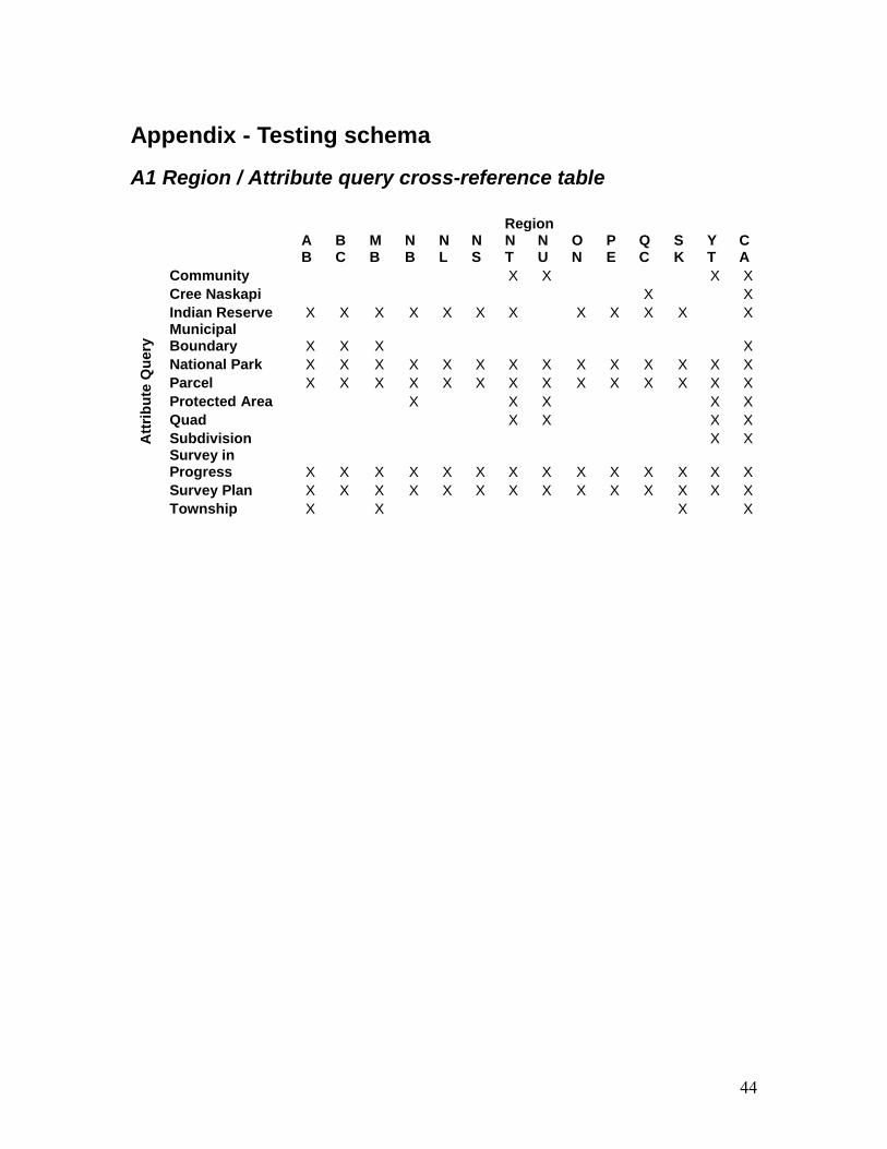
Appendix - Testing schema
A1 Region / Attribute query cross-reference table
Region
AB
BC
MB
NB
NL
NS
NT
NU
ON
PE
QC
SK
YT
CA
Attr
ibut
e Q
uery
Community X X X X Cree Naskapi X X Indian Reserve X X X X X X X X X X X X Municipal Boundary X X X X National Park X X X X X X X X X X X X X X Parcel X X X X X X X X X X X X X X Protected Area X X X X X Quad X X X X Subdivision X X Survey in Progress X X X X X X X X X X X X X X Survey Plan X X X X X X X X X X X X X X Township X X X X

45
A2 Region – Layer cross-reference table
Region AB BC MB NB NL NS NT NU ON PE QC SK YT CA MinScale MaxScale Visible
Ava
ilabl
e La
yers
Archived surveyed line X X X X X X X X X X X 250,000 0 TRUE Cadastral Line X X X X X X X X X X X 200,000 0 TRUE Cadastral text X X X X X X X X X 50,000 0 FALSE Community X X X X X X X X X X X 5,000,000 128,000 TRUE Condominium X X X X X X X X X X X 250,000 0 TRUE Cree/Naskapi Administrative Lot X X 200,000 0 TRUE Cree/Naskapi Block X X 4,000,000 0 TRUE Cree/Naskapi Lot X X 250,000 0 TRUE Cree/Naskapi Right X X 200,000 0 TRUE Easement X X X X X X X X 500,000 0 TRUE Easement other X X X X X X X X 200,000 0 TRUE Easement text X X X X X X X X X 50,000 0 FALSE Field notes X X X X X X X X X X X 200,000 0 TRUE Group X X X X X X X X X X X 5,000,000 128,000 TRUE Inconclusive Parcel X X X X X X X X X X X 250,000 0 TRUE Indian Reserve X X X X X X X X X X X 5,000,000 128,000 TRUE Indian Reserve Designation X X X X X X X X X 50,000 0 TRUE Indian Reserve lease X X X X X X X X X 50,000 0 TRUE IR Surface Oil Gas X X X X X X X 500,000 0 TRUE Land Claim Settlement area X X X X X X X X X X 5,000,000 128,000 TRUE Land Parcel X X X X X X X X X X 500,000 0 TRUE Land Parcel Other X X X X X X X X X X 500,000 0 TRUE Mineral Claim Location Line X X X X 500,000 0 TRUE Mineral claims X X X X 500,000 0 TRUE Municipal boundary X X X X X X X X X X 5,000,000 128,000 TRUE National Park X X X X X X X X X X 100,000,000 500,000 TRUE Other surveyed line X X X X X X X X X X 250,000 0 TRUE Placer claim base line X X X X 500,000 0 TRUE

46
Surveys in progress X X X X X X X X X 500,000 0 TRUE Protected area X X X X X X X X X X 5,000,000 128,000 TRUE Provisional line X X X X X X X X X 200,000 0 TRUE Quad X X X X X X X X X X 5,000,000 128,000 TRUE Settlement land X X X X X X X X X X 5,000,000 128,000 TRUE Strata parcel X X X X X X X X X X 250,000 0 TRUE Subdivision X X X X X X X X X X 5,000,000 128,000 TRUE Sub-Surface Oil Gas Parcel X X X X X X X 1,000,000 0 TRUE Sub-Surface Oil Gas Surveyed Unit X X X X X X X 1,000,000 0 TRUE Territorial park X X X X X X X X X X 5,000,000 128,000 TRUE Township section X X X X X X X X X X 5,000,000 128,000 TRUE Unresolved Parcel X X X X X X X X X X 250,000 0 TRUE Yukon First Nation lot within settlement land X 200,000 0 TRUE Yukon First Nation Parcel X 500,000 0 TRUE