user’s guide and referenceusers.sdsc.edu/~jrowley/db2/spatial - users gd and ref.pdf ·...
TRANSCRIPT

IBM®
DB2®
Spatial Extender
User’s Guide and Reference
Version 8
SC27-1226-00
���

IBM®
DB2®
Spatial Extender
User’s Guide and Reference
Version 8
SC27-1226-00
���

Before using this information and the product it supports, be sure to read the general information under Notices.
This document contains proprietary information of IBM. It is provided under a license agreement and is protected bycopyright law. The information contained in this publication does not include any product warranties, and anystatements provided in this manual should not be interpreted as such.
You can order IBM publications online or through your local IBM representative.v To order publications online, go to the IBM Publications Center at www.ibm.com/shop/publications/order
v To find your local IBM representative, go to the IBM Directory of Worldwide Contacts atwww.ibm.com/planetwide
To order DB2 publications from DB2 Marketing and Sales in the United States or Canada, call 1-800-IBM-4YOU(426-4968).
When you send information to IBM, you grant IBM a nonexclusive right to use or distribute the information in anyway it believes appropriate without incurring any obligation to you.
© Copyright International Business Machines Corporation 1998 - 2002. All rights reserved.US Government Users Restricted Rights – Use, duplication or disclosure restricted by GSA ADP Schedule Contractwith IBM Corp.

Contents
Part 1. Introduction. . . . . . . . 1
Chapter 1. About DB2 Spatial Extender . . 3The purpose of DB2 Spatial Extender . . . . 3Spatial data . . . . . . . . . . . . 4
How data represents geographic features. . 4The nature of spatial data . . . . . . . 6Where spatial data comes from . . . . . 7
How features, spatial information, spatial data,and geometries fit together . . . . . . . 8
Chapter 2. About Geometries . . . . . 11Geometries . . . . . . . . . . . . 11Properties of geometries . . . . . . . . 13
Type . . . . . . . . . . . . . 13Geometry coordinates . . . . . . . . 14X and Y coordinates . . . . . . . . 14Z coordinates . . . . . . . . . . 15M coordinates . . . . . . . . . . 15Interior, boundary, and exterior . . . . 15Simple or non-simple . . . . . . . . 15Empty or not empty . . . . . . . . 15Minimum bounding rectangle (MBR) . . 15Dimension . . . . . . . . . . . 15Spatial reference system identifier . . . . 16
Chapter 3. How to use DB2 SpatialExtender . . . . . . . . . . . . . 17How to use DB2 Spatial Extender . . . . . 17
Interfaces to DB2 Spatial Extender andassociated functionality . . . . . . . 17Tasks that you perform to set up DB2Spatial Extender and create projects . . . 17
Part 2. Setting up DB2 SpatialExtender . . . . . . . . . . . . 25
Chapter 4. Getting started with DB2 SpatialExtender . . . . . . . . . . . . . 27Setting up and configuring SpatialExtender—Steps. . . . . . . . . . . 27
Setting up and configuring SpatialExtender . . . . . . . . . . . . 27
System requirements for installing SpatialExtender . . . . . . . . . . . . 28Installing DB2 Spatial Extender forWindows . . . . . . . . . . . . 30Installing DB2 Spatial Extender for AIX . . 32Installing DB2 Spatial Extender for HP-UX 34Installing DB2 Spatial Extender for SolarisOperating Environment . . . . . . . 36Installing DB2 Spatial Extender for Linuxand Linux OS/390 . . . . . . . . . 38Creating the DB2 Spatial Extender instanceenvironment . . . . . . . . . . . 40Verifying the Spatial Extender installation 42Troubleshooting tips for the installationsample program . . . . . . . . . 44
Post-Installation considerations. . . . . . 45Downloading ArcExplorer . . . . . . 45Accessing geocoder reference data . . . 45CD-ROMs for DB2 Spatial Extender dataand maps . . . . . . . . . . . . 47
Chapter 5. Migrating the Spatial Extenderenvironment to DB2 Universal DatabaseVersion 8 . . . . . . . . . . . . 49Migrating a spatially-enabled database . . . 49
Migrating from a 32–bit to a 64–bitenvironment . . . . . . . . . . . 50Migration messages . . . . . . . . 51
Chapter 6. Setting up a database . . . . 53Configuring a database to accommodatespatial data . . . . . . . . . . . . 53Tuning the database configuration parameters 53
Tuning transaction log characteristics . . 53Tuning the application heap size . . . . 55Tuning the application control heap size 56
Chapter 7. Setting up spatial resources fora database . . . . . . . . . . . . 59How to set up resources in your database . . 59
Inventory of resources supplied for yourdatabase . . . . . . . . . . . . 59Enabling a database for spatial operations 60
How to work with reference data . . . . . 61Reference data . . . . . . . . . . 61
© Copyright IBM Corp. 1998 - 2002 iii
Setting up access to reference data . . . 61Registering a geocoder . . . . . . . 62
Part 3. Creating projects that usespatial data . . . . . . . . . . 63
Chapter 8. Setting up spatial resources fora project . . . . . . . . . . . . . 65How to use coordinate systems . . . . . 65
Coordinate systems . . . . . . . . 65Selecting or creating coordinate systems. . 73
How to set up spatial reference systems. . . 74About spatial reference systems . . . . 74Selecting or creating spatial referencesystems . . . . . . . . . . . . 76
Chapter 9. Setting up spatial columns . . 83Spatial columns . . . . . . . . . . . 83
Spatial columns with viewable content . . 83Spatial data types . . . . . . . . . 83
Creating spatial columns . . . . . . . . 86Setting up spatial columns for access byvisualization tools . . . . . . . . . . 86
Chapter 10. Populating spatial columns . . 89How to import and export spatial data . . . 89
About importing and exporting spatialdata. . . . . . . . . . . . . . 89Importing spatial data . . . . . . . 91Exporting spatial data. . . . . . . . 94
How to use a geocoder . . . . . . . . 96Geocoders and geocoding . . . . . . 96Setting up geocoding operations . . . . 98Setting up a geocoder to runautomatically . . . . . . . . . . 101Running a geocoder in batch mode . . . 102
Chapter 11. Using indexes and views toaccess spatial data. . . . . . . . . 105Spatial indexes . . . . . . . . . . . 105How to create spatial grid indexes . . . . 106
Creating spatial grid indexes . . . . . 107General guidelines for getting the mostout of spatial grid indexes . . . . . . 110
Using the Index Advisor . . . . . . . 111Using views to access spatial columns . . . 118
Chapter 12. Analyzing and Generatingspatial information . . . . . . . . . 119
Environments for performing spatial analysis 119Examples of spatial function operations . . 119Rules for using grid indexes to optimizespatial functions . . . . . . . . . . 121
Chapter 13. DB2 Spatial Extendercommands . . . . . . . . . . . 123Invoking commands for setting up DB2Spatial Extender and developing projects . . 123
Chapter 14. Writing applications andusing the sample program . . . . . . 131Writing applications for DB2 SpatialExtender . . . . . . . . . . . . . 131Including the DB2 Spatial Extender headerfile in spatial applications . . . . . . . 131Calling DB2 Spatial Extender storedprocedures from an application . . . . . 132The DB2 Spatial Extender sample program 134
Chapter 15. Identifying DB2 SpatialExtender problems . . . . . . . . . 143How to interpret DB2 Spatial Extendermessages. . . . . . . . . . . . . 143DB2 Spatial Extender stored procedureoutput parameters . . . . . . . . . 146DB2 Spatial Extender function messages . . 148DB2 Spatial Extender CLP messages . . . 150DB2 Control Center messages . . . . . . 153Tracing DB2 Spatial Extender problems withthe db2trc command . . . . . . . . . 154The db2diag.log utility . . . . . . . . 155
Part 4. Reference material . . . . 157
Chapter 16. Stored procedures . . . . 159GSE_export_sde . . . . . . . . . . 160GSE_import_sde . . . . . . . . . . 162ST_alter_coordsys . . . . . . . . . . 165ST_alter_srs . . . . . . . . . . . . 167ST_create_coordsys . . . . . . . . . 172ST_create_srs . . . . . . . . . . . 174ST_disable_autogeocoding . . . . . . . 182ST_disable_db . . . . . . . . . . . 184ST_drop_coordsys . . . . . . . . . 186ST_drop_srs. . . . . . . . . . . . 187ST_enable_autogeocoding . . . . . . . 189ST_enable_db . . . . . . . . . . . 191ST_export_shape . . . . . . . . . . 194
Table of contents
iv DB2 Spatial Extender User’s Guide and Reference
ST_import_shape . . . . . . . . . . 198ST_register_geocoder. . . . . . . . . 207ST_register_spatial_column . . . . . . 212ST_remove_geocoding_setup . . . . . . 215ST_run_geocoding . . . . . . . . . 217ST_setup_geocoding . . . . . . . . . 220ST_unregister_geocoder . . . . . . . . 224ST_unregister_spatial_column. . . . . . 226
Chapter 17. Catalog views . . . . . . 229The DB2GSE.ST_COORDINATE_SYSTEMScatalog view . . . . . . . . . . . 229The DB2GSE.ST_GEOMETRY_COLUMNScatalog view . . . . . . . . . . . 231TheDB2GSE.ST_GEOCODER_PARAMETERScatalog view . . . . . . . . . . . 232The DB2GSE.ST_GEOCODERS catalog view 233The DB2GSE.ST_GEOCODING catalog view 234TheDB2GSE.ST_GEOCODING_PARAMETERScatalog view . . . . . . . . . . . 236The DB2GSE.ST_SIZINGS catalog view . . 238TheDB2GSE.ST_SPATIAL_REFERENCE_SYSTEMScatalog view . . . . . . . . . . . 238The DB2GSE.ST_UNITS_OF_MEASUREcatalog view . . . . . . . . . . . 242
Chapter 18. Spatial functions: categoriesand uses . . . . . . . . . . . . 243Spatial functions that convert geometries toand from data exchange formats . . . . . 243
Constructor functions in general . . . . 243Well-known text (WKT) representation 248Well-known binary (WKB) representation 249ESRI shape representation . . . . . . 250Geography Markup Language (GML)representation . . . . . . . . . . 251
Functions that make comparisons . . . . 252Comparison functions in general . . . . 252Descriptions of functions . . . . . . 254Differences between similar functions . . 264
Functions that return information aboutproperties of geometries . . . . . . . 266
ST_GeometryType: A function forinformation about data types . . . . . 266Functions for information aboutcoordinates and measures . . . . . . 266
Functions for information aboutgeometries within a geometry. . . . . 268Functions for information about rings,boundaries, envelopes, and minimumbounding rectangles . . . . . . . . 270Functions for information aboutdimensions . . . . . . . . . . . 271Functions for information as to whether ageometry is closed, empty, or simple . . 272Functions for information about spatialreference systems . . . . . . . . . 272
Spatial functions that generate newgeometries . . . . . . . . . . . . 273
Functions for converting geometries intoother geometries . . . . . . . . . 273Functions for creating geometries thatrepresent configurations of space . . . 274Functions for deriving individualgeometries from multiple geometries . . 278Functions for creating geometries basedon measures . . . . . . . . . . 279Functions for creating modified forms ofgeometries . . . . . . . . . . . 280
Miscellaneous spatial functions . . . . . 282
Chapter 19. Spatial functions: syntax andparameters . . . . . . . . . . . 285Spatial functions: considerations andassociated data types . . . . . . . . 285
Factors to consider . . . . . . . . 285Treating values of ST_Geometry as valuesof a subtype . . . . . . . . . . 286Spatial functions listed according to inputtype . . . . . . . . . . . . . 287
MBR Aggregate . . . . . . . . . . 291ST_AppendPoint . . . . . . . . . . 292ST_Area . . . . . . . . . . . . . 294ST_AsBinary . . . . . . . . . . . 297ST_AsGML . . . . . . . . . . . . 298ST_AsShape. . . . . . . . . . . . 300ST_AsText . . . . . . . . . . . . 301ST_Boundary . . . . . . . . . . . 302ST_Buffer . . . . . . . . . . . . 304ST_Centroid . . . . . . . . . . . 307ST_ChangePoint . . . . . . . . . . 308ST_Contains . . . . . . . . . . . 310ST_ConvexHull . . . . . . . . . . 312ST_CoordDim . . . . . . . . . . . 314ST_Crosses . . . . . . . . . . . . 315ST_Difference . . . . . . . . . . . 317
Table of contents
Contents v

ST_Dimension . . . . . . . . . . . 319ST_Disjoint . . . . . . . . . . . . 320ST_Edge_GC_USA . . . . . . . . . 322ST_Distance. . . . . . . . . . . . 327ST_Endpoint . . . . . . . . . . . 331ST_Envelope . . . . . . . . . . . 332ST_EnvIntersects . . . . . . . . . . 333ST_EqualCoordsys . . . . . . . . . 335ST_Equals . . . . . . . . . . . . 336ST_EqualSRS . . . . . . . . . . . 338ST_ExteriorRing . . . . . . . . . . 339ST_FindMeasure or ST_LocateAlong . . . 341ST_Generalize . . . . . . . . . . . 343ST_GeomCollection . . . . . . . . . 345ST_GeomCollFromTxt . . . . . . . . 347ST_GeomCollFromWKB. . . . . . . . 349ST_Geometry . . . . . . . . . . . 351ST_GeometryN . . . . . . . . . . 353ST_GeometryType . . . . . . . . . 354ST_GeomFromText . . . . . . . . . 355ST_GeomFromWKB . . . . . . . . . 357ST_GetIndexParms . . . . . . . . . 358ST_InteriorRingN . . . . . . . . . . 361ST_Intersection. . . . . . . . . . . 363ST_Intersects . . . . . . . . . . . 364ST_Is3d . . . . . . . . . . . . . 366ST_IsClosed. . . . . . . . . . . . 368ST_IsEmpty . . . . . . . . . . . . 370ST_IsMeasured. . . . . . . . . . . 371ST_IsRing . . . . . . . . . . . . 372ST_IsSimple. . . . . . . . . . . . 373ST_IsValid . . . . . . . . . . . . 375ST_Length . . . . . . . . . . . . 376ST_LineFromText . . . . . . . . . . 378ST_LineFromWKB . . . . . . . . . 379ST_LineString . . . . . . . . . . . 381ST_LineStringN . . . . . . . . . . 383ST_M . . . . . . . . . . . . . . 384ST_MaxM . . . . . . . . . . . . 386ST_MaxX . . . . . . . . . . . . 388ST_MaxY . . . . . . . . . . . . 390ST_MaxZ . . . . . . . . . . . . 392ST_MBR . . . . . . . . . . . . . 393ST_MBRIntersects . . . . . . . . . . 395ST_MeasureBetween, ST_LocateBetween . . 397ST_MidPoint . . . . . . . . . . . 398ST_MinM . . . . . . . . . . . . 400ST_MinX. . . . . . . . . . . . . 401ST_MinY. . . . . . . . . . . . . 403ST_MinZ. . . . . . . . . . . . . 405
ST_MLineFromText . . . . . . . . . 407ST_MLineFromWKB . . . . . . . . . 408ST_MPointFromText . . . . . . . . . 411ST_MPointFromWKB . . . . . . . . 412ST_MPolyFromText . . . . . . . . . 414ST_MPolyFromWKB . . . . . . . . . 416ST_MultiLineString . . . . . . . . . 418ST_MultiPoint . . . . . . . . . . . 420ST_MultiPolygon . . . . . . . . . . 422ST_NumGeometries . . . . . . . . . 424ST_NumInteriorRing . . . . . . . . . 425ST_NumLineStrings . . . . . . . . . 427ST_NumPoints . . . . . . . . . . . 428ST_NumPolygons . . . . . . . . . . 429ST_Overlaps . . . . . . . . . . . 430ST_Perimeter . . . . . . . . . . . 432ST_PerpPoints . . . . . . . . . . . 434ST_Point . . . . . . . . . . . . . 437ST_PointFromText. . . . . . . . . . 440ST_PointFromWKB . . . . . . . . . 442ST_PointN . . . . . . . . . . . . 443ST_PointOnSurface . . . . . . . . . 444ST_PolyFromText . . . . . . . . . . 446ST_PolyFromWKB . . . . . . . . . 447ST_Polygon . . . . . . . . . . . . 449ST_PolygonN . . . . . . . . . . . 452ST_Relate . . . . . . . . . . . . 453ST_RemovePoint . . . . . . . . . . 454ST_SrsId, ST_SRID . . . . . . . . . 456ST_SrsName . . . . . . . . . . . 458ST_StartPoint . . . . . . . . . . . 459ST_SymDifference. . . . . . . . . . 460ST_ToGeomColl . . . . . . . . . . 463ST_ToLineString . . . . . . . . . . 464ST_ToMultiLine . . . . . . . . . . 465ST_ToMultiPoint . . . . . . . . . . 466ST_ToMultiPolygon . . . . . . . . . 468ST_ToPoint . . . . . . . . . . . . 469ST_ToPolygon . . . . . . . . . . . 470ST_Touches . . . . . . . . . . . . 471ST_Transform . . . . . . . . . . . 473ST_Union . . . . . . . . . . . . 475ST_Within . . . . . . . . . . . . 478ST_WKBToSQL . . . . . . . . . . 479ST_WKTToSQL . . . . . . . . . . 481ST_X . . . . . . . . . . . . . . 482ST_Y . . . . . . . . . . . . . . 484ST_Z . . . . . . . . . . . . . . 485Union aggregate . . . . . . . . . . 487
Table of contents
vi DB2 Spatial Extender User’s Guide and Reference
Chapter 20. Transform groups . . . . . 489Transform groups . . . . . . . . . . 489
ST_WellKnownText . . . . . . . . 489ST_WellKnownBinary . . . . . . . 491ST_Shape . . . . . . . . . . . 492ST_GML . . . . . . . . . . . . 493
Chapter 21. Supported data formats. . . 497Well-known text (WKT) representation. . . 497Well-known binary (WKB) representation 503Shape representation . . . . . . . . . 505Geography Markup Language (GML)representation . . . . . . . . . . . 505
Chapter 22. Supported coordinatesystems . . . . . . . . . . . . 507Supported coordinate systems . . . . . 507
Coordinate systems syntax . . . . . . 507Supported angular units . . . . . . 510Supported spheroids . . . . . . . . 510Supported geodetic datums . . . . . 512Supported prime meridians . . . . . 514Supported map projections. . . . . . 515
Appendix A. Deprecated storedprocedures . . . . . . . . . . . 519db2gse.gse_enable_autogc . . . . . . . 520db2gse.gse_enable_db . . . . . . . . 522db2gse.gse_enable_idx . . . . . . . . 523db2gse.gse_enable_sref . . . . . . . . 524db2gse.gse_export_shape . . . . . . . 526db2gse.gse_disable_autogc . . . . . . . 528db2gse.gse_disable_db . . . . . . . . 529db2gse.gse_disable_sref . . . . . . . . 530db2gse.gse_import_shape . . . . . . . 531db2gse.gse_register_gc . . . . . . . . 533db2gse.gse_register_layer . . . . . . . 535db2gse.gse_run_gc . . . . . . . . . 541db2gse.gse_unregist_gc . . . . . . . . 542db2gse.gse_unregist_layer . . . . . . . 543
Appendix B. Deprecated catalog views 547DB2GSE.COORD_REF_SYS . . . . . . 547DB2GSE.GEOMETRY_COLUMNS . . . . 548DB2GSE.SPATIAL_GEOCODER . . . . . 548
DB2GSE.SPATIAL_REF_SYS . . . . . . 549
Appendix C. Deprecated spatial functions 551AsShape . . . . . . . . . . . . . 552EnvelopesIntersect . . . . . . . . . 552GeometryFromShape. . . . . . . . . 553Is3d . . . . . . . . . . . . . . 553IsMeasured . . . . . . . . . . . . 553LineFromShape . . . . . . . . . . 554LocateAlong . . . . . . . . . . . 554LocateBetween . . . . . . . . . . . 554M . . . . . . . . . . . . . . . 555MLine FromShape . . . . . . . . . 555MPointFromShape . . . . . . . . . 555MPolyFromShape . . . . . . . . . . 556PointFromShape . . . . . . . . . . 556PolyFromShape . . . . . . . . . . 556ShapeToSQL . . . . . . . . . . . 557ST_GeomFromText . . . . . . . . . 557ST_GeomFromWKB . . . . . . . . . 558ST_LineFromText . . . . . . . . . . 558ST_LineFromWKB . . . . . . . . . 558ST_MLineFromText . . . . . . . . . 559ST_MLineFromWKB . . . . . . . . . 559ST_MPointFromText . . . . . . . . . 559ST_MPointFromWKB . . . . . . . . 560ST_MPolyFromText . . . . . . . . . 560ST_MPolyFromWKB . . . . . . . . . 561ST_OrderingEquals . . . . . . . . . 561ST_Point . . . . . . . . . . . . . 561ST_PointFromText. . . . . . . . . . 562ST_PolyFromText . . . . . . . . . . 562ST_PolyFromWKB . . . . . . . . . 562ST_Transform . . . . . . . . . . . 563ST_SymmetricDiff. . . . . . . . . . 563Z . . . . . . . . . . . . . . . 564
Notices . . . . . . . . . . . . . 565Trademarks . . . . . . . . . . . . 568
Index . . . . . . . . . . . . . 571
Contacting IBM . . . . . . . . . . 575Product information . . . . . . . . . 575
Table of contents
Contents vii

viii DB2 Spatial Extender User’s Guide and Reference

Part 1. Introduction
© Copyright IBM Corp. 1998 - 2002 1

2 DB2 Spatial Extender User’s Guide and Reference

Chapter 1. About DB2 Spatial Extender
This chapter introduces DB2 Spatial Extender by explaining its purpose,describing the data that it supports, and explaining how its underlyingconcepts fit together.
The purpose of DB2 Spatial Extender
Use DB2® Spatial Extender to generate and analyze spatial information aboutgeographic features, and to store and manage the data on which thisinformation is based. A geographic feature (sometimes called feature in thisdiscussion, for short) is anything in the real world that has an identifiablelocation, or anything that could be imagined as existing at an identifiablelocation. A feature can be:v An object (that is, a concrete entity of any sort); for example, a river, forest,
or range of mountains.v A space; for example, a safety zone around a hazardous site, or the
marketing area serviced by a particular business.v An event that occurs at a definable location; for example, an auto accident
that occurred at a particular intersection, or a sales transaction at a specificstore.
Features exist in multiple environments. For example, the objects mentionedin the preceding list—river, forest, mountain range—belong to the naturalenvironment. Other objects, such as cities, buildings, and offices, belong to thecultural environment. Still others, such as parks, zoos, and farmland, representa combination of the natural and cultural environments.
In this discussion, the term spatial information refers to the kind of informationthat DB2 Spatial Extender makes available to its users—namely, facts andfigures about the locations of geographic features. Examples of spatialinformation are:v Locations of geographic features on the map (for example, longitude and
latitude values that define where cities are situated)v The location of geographic features with respect to one another (for
example, points within a city where hospitals and clinics are located, or theproximity of the city’s residences to local earthquake zones)
© Copyright IBM Corp. 1998 - 2002 3

v Ways in which geographic features are related to each other (for example,information that a certain river system is enclosed within a specific region,or that certain bridges in that region cross over the river system’stributaries)
v Measurements that apply to one or more geographic features (for example,the distance between an office building and its lot line, or the length of abird preserve’s perimeter)
Spatial information, either by itself or in combination with traditionalrelational data, can help you with such activities as defining the areas inwhich you provide services, and determining locations of possible markets.For example, suppose that the manager of a county welfare district needs toverify which welfare applicants and recipients actually live within the areathat the district services. DB2 Spatial Extender can derive this informationfrom the serviced area’s location and from the addresses of the applicants andrecipients.
Or suppose that the owner of a restaurant chain wants to do business innearby cities. To determine where to open new restaurants, the owner needsanswers to such questions as: Where in these cities are concentrations ofclientele who typically frequent my restaurants? Where are the majorhighways? Where is the crime rate lowest? Where are the competition’srestaurants located? DB2 Spatial Extender and DB2 can produce informationto answer these questions. Furthermore, front-end tools, though not required,can play a part. To illustrate: a visualization tool can put informationproduced by DB2 Spatial Extender—for example, the location ofconcentrations of clientele and the proximity of major highways to proposedrestaurants—in graphic form on a map. Business intelligence tools can putassociated information—for example, names and descriptions of competingrestaurants—in report form.
Spatial data
This section provides an overview of the data that you generate, store, andmanipulate to obtain spatial information. The topics covered are:v How data represents geographic featuresv The nature of spatial datav Ways to produce spatial data
How data represents geographic featuresIn DB2® Spatial Extender, a geographic feature can be represented by one ormore data items; for example, the data items in a row of a table. (A data itemis the value or values that occupy the cell of a relational table.) For example,consider office buildings and residences. In Figure 1 on page 5, each row of
About DB2 Spatial Extender
4 DB2 Spatial Extender User’s Guide and Reference
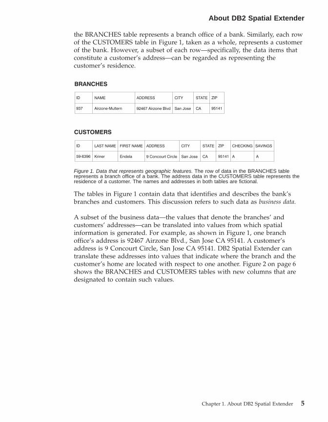
the BRANCHES table represents a branch office of a bank. Similarly, each rowof the CUSTOMERS table in Figure 1, taken as a whole, represents a customerof the bank. However, a subset of each row—specifically, the data items thatconstitute a customer’s address—can be regarded as representing thecustomer’s residence.
The tables in Figure 1 contain data that identifies and describes the bank’sbranches and customers. This discussion refers to such data as business data.
A subset of the business data—the values that denote the branches’ andcustomers’ addresses—can be translated into values from which spatialinformation is generated. For example, as shown in Figure 1, one branchoffice’s address is 92467 Airzone Blvd., San Jose CA 95141. A customer’saddress is 9 Concourt Circle, San Jose CA 95141. DB2 Spatial Extender cantranslate these addresses into values that indicate where the branch and thecustomer’s home are located with respect to one another. Figure 2 on page 6shows the BRANCHES and CUSTOMERS tables with new columns that aredesignated to contain such values.
Figure 1. Data that represents geographic features. The row of data in the BRANCHES tablerepresents a branch office of a bank. The address data in the CUSTOMERS table represents theresidence of a customer. The names and addresses in both tables are fictional.
About DB2 Spatial Extender
Chapter 1. About DB2 Spatial Extender 5

Because spatial information will be derived from the data items stored in theLOCATION column, these data items are referred to in this discussion asspatial data.
The nature of spatial dataMuch spatial data is made up of coordinates. A coordinate is a number thatdenotes a position that is relative to a point of reference. For example, degreesof latitude are coordinates that denote positions relative to the equator.Degrees of longitude are coordinates that denote positions relative to theGreenwich meridian. Thus, on a map, the position of Yellowstone NationalPark is defined by 44.45 latitude degrees north of the equator and 110.40degrees of longitude west of the Greenwich meridian. More precisely, thesecoordinates reference the center of Yellowstone National Park.
Latitudes, longitudes, their points of reference, units of measure, and otherassociated parameters are referred to collectively as a coordinate system.Coordinate systems that are based on values other than latitude and longitudealso exist. These coordinate systems have their own points of reference, unitsof measure, and additional distinguishing parameters.
The simplest spatial data item consists of two coordinates that define theposition of a single geographic feature. A more extensive spatial data itemconsists of several coordinates that define a linear path such as a road or rivermight form. A third kind consists of coordinates that define the boundary ofan area; for example, the boundary of a land parcel or flood plain.
Each spatial data item is an instance of a spatial data type. The data type forcoordinates that mark a single location is ST_Point; the data type forcoordinates that define a linear path is ST_LineString; and the data type forcoordinates that define the boundary of an area is ST_Polygon. These types,together with the other spatial data types, are structured types that belong toa single hierarchy.
Figure 2. Tables with spatial columns added. In each table, the LOCATION column will containcoordinates that correspond to the addresses.
About DB2 Spatial Extender
6 DB2 Spatial Extender User’s Guide and Reference
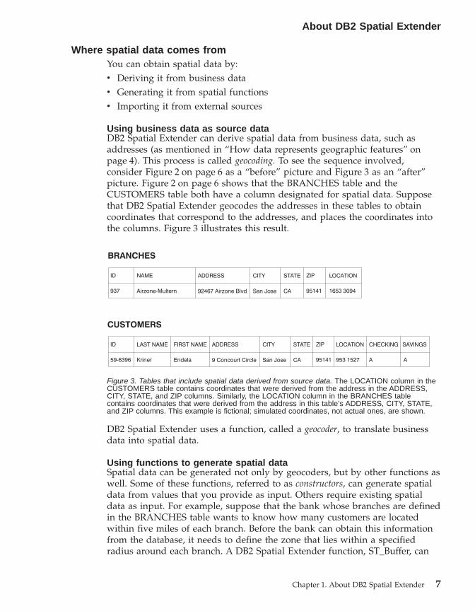
Where spatial data comes fromYou can obtain spatial data by:v Deriving it from business datav Generating it from spatial functionsv Importing it from external sources
Using business data as source dataDB2 Spatial Extender can derive spatial data from business data, such asaddresses (as mentioned in “How data represents geographic features” onpage 4). This process is called geocoding. To see the sequence involved,consider Figure 2 on page 6 as a “before” picture and Figure 3 as an “after”picture. Figure 2 on page 6 shows that the BRANCHES table and theCUSTOMERS table both have a column designated for spatial data. Supposethat DB2 Spatial Extender geocodes the addresses in these tables to obtaincoordinates that correspond to the addresses, and places the coordinates intothe columns. Figure 3 illustrates this result.
DB2 Spatial Extender uses a function, called a geocoder, to translate businessdata into spatial data.
Using functions to generate spatial dataSpatial data can be generated not only by geocoders, but by other functions aswell. Some of these functions, referred to as constructors, can generate spatialdata from values that you provide as input. Others require existing spatialdata as input. For example, suppose that the bank whose branches are definedin the BRANCHES table wants to know how many customers are locatedwithin five miles of each branch. Before the bank can obtain this informationfrom the database, it needs to define the zone that lies within a specifiedradius around each branch. A DB2 Spatial Extender function, ST_Buffer, can
Figure 3. Tables that include spatial data derived from source data. The LOCATION column in theCUSTOMERS table contains coordinates that were derived from the address in the ADDRESS,CITY, STATE, and ZIP columns. Similarly, the LOCATION column in the BRANCHES tablecontains coordinates that were derived from the address in this table’s ADDRESS, CITY, STATE,and ZIP columns. This example is fictional; simulated coordinates, not actual ones, are shown.
About DB2 Spatial Extender
Chapter 1. About DB2 Spatial Extender 7

create such a definition. Using the coordinates of each branch as input,ST_Buffer can generate the coordinates that demarcate the perimeters of thezones. Figure 4 shows the BRANCHES table with information that is suppliedby ST_Buffer.
In addition to ST_Buffer, DB2 Spatial Extender provides several otherfunctions that derive new spatial data from existing spatial data. Forreferences to ST_Buffer and these other functions, see Related references atthe end of this section.
Importing spatial dataA third way to obtain spatial data is to import it from files provided byexternal data sources. These files typically contain data that is applied tomaps: street networks, flood plains, earthquake faults, and so on. By usingsuch data in combination with spatial data that you produce, you canaugment the spatial information available to you. For example, if a publicworks department needs to determine what hazards a residential communityis vulnerable to, it could use ST_Buffer to define a zone around thecommunity. The public works department could then import data on floodplains and earthquake faults to see which of these problem areas overlap thiszone.
How features, spatial information, spatial data, and geometries fit together
This section summarizes several basic concepts that underlie the operations ofDB2® Spatial Extender: geographic features, spatial information, spatial data,and geometries.
DB2 Spatial Extender lets you obtain facts and figures that pertain to thingsthat can be defined geographically—that is, in terms of their location on earth,or within a region of the earth. The DB2 library refers to such facts andfigures as spatial information, and to the things as geographic features (calledfeatures here, for short).
Figure 4. Table that includes new spatial data derived from existing spatial data. The coordinates inthe SALES_AREA column were derived by the ST_Buffer function from the coordinates in theLOCATION column. Like the coordinates in the LOCATION column, those in the SALES_AREAcolumn are simulated; they are not actual.
About DB2 Spatial Extender
8 DB2 Spatial Extender User’s Guide and Reference

For example, you could use DB2 Spatial Extender to determine whether anypopulated areas overlap the proposed site for a landfill. The populated areasand the proposed site are features. A finding as to whether any overlap existswould be an example of spatial information. If overlap is found to exist, theextent of it would also be an example of spatial information.
To produce spatial information, DB2 Spatial Extender must process data thatdefines the locations of features. Such data, called spatial data in the DB2library, consists of coordinates that reference the locations on a map or similarprojection. For example, to determine whether one feature overlaps another,DB2 Spatial Extender must determine where the coordinates of one of thefeatures are situated with respect to the coordinates of the other.
In the world of spatial information technology, it is common to think offeatures as being represented by symbols called geometries. Geometries arepartly visual and partly mathematical. Consider their visual aspect. Thesymbol for a feature that has width and breadth, such as a park or town, is amultisided figure. Such a geometry is called a polygon. The symbol for a linearfeature, such as a river or a road, is a line. Such a geometry is called alinestring.
A geometry has properties that correspond to facts about the feature that itrepresents. Most of these properties can be expressed mathematically. Forexample, the coordinates for a feature collectively constitute one of theproperties of the feature’s corresponding geometry. Another property, calleddimension, is a numerical value that indicates whether a feature has length orbreadth.
Spatial data and certain spatial information can be viewed in terms ofgeometries. Consider the example, described earlier, of the populated areasand the proposed landfill site. The spatial data for the populated areasincludes coordinates stored in a column of a table in a DB2 database. Theconvention is to regard what is stored not simply as data, but as actualgeometries. Because populated areas have width and breadth, you can seethat these geometries are polygons.
Like spatial data, certain spatial information is also viewed in terms ofgeometries. For example, to determine whether a populated area overlaps aproposed landfill site, DB2 Spatial Extender must compare the coordinates inthe polygon that symbolizes the site with the coordinates of the polygons thatrepresent populated areas. The resulting information—that is, the areas ofoverlap—are themselves regarded as polygons: geometries with coordinates,dimension, and other properties
About DB2 Spatial Extender
Chapter 1. About DB2 Spatial Extender 9

Introduction
10 DB2 Spatial Extender User’s Guide and Reference
Chapter 2. About Geometries
This chapter discusses entities of information, called geometries, that consistof coordinates and represent geographic features. The topics covered are:v Geometriesv Properties of geometries
Geometries
Webster’s Revised Unabridged Dictionary defines geometry as “That branch ofmathematics which investigates the relations, properties, and measurement ofsolids, surfaces, lines, and angles; the science which treats of the propertiesand relations of magnitudes; the science of the relations of space.” . The wordgeometry has also been used to denote the geometric features that, for the pastmillennium or more, cartographers have used to map the world. An abstractdefinition of this new meaning of geometry is “a point or aggregate of pointsrepresenting a feature on the ground.”
In DB2® Spatial Extender, the operational definition of geometry is “a model ofa geographic feature.” The model can be expressed in terms of the feature’scoordinates. The model conveys information; for example, the coordinatesidentify the position of the feature with respect to fixed points of reference.Also, the model can be used to produce information; for example, theST_Overlaps function can take the coordinates of two proximate regions asinput and return information as to whether the regions overlap or not.
The coordinates of a feature that a geometry represents are regarded asproperties of the geometry. Several kinds of geometries have other properties aswell; for example area, length, and boundary.
The geometries supported by DB2 Spatial Extender form a hierarchy, which isshown in the following figure. The geometry hierarchy is defined by theOpenGIS Consortium, Inc. (OGC) document ″OpenGIS Simple FeaturesSpecification for SQL″. Six members of the hierarchy are instantiable; they canbe defined with specific coordinate values and rendered visually as shown inthe examples in the figure.
© Copyright IBM Corp. 1998 - 2002 11
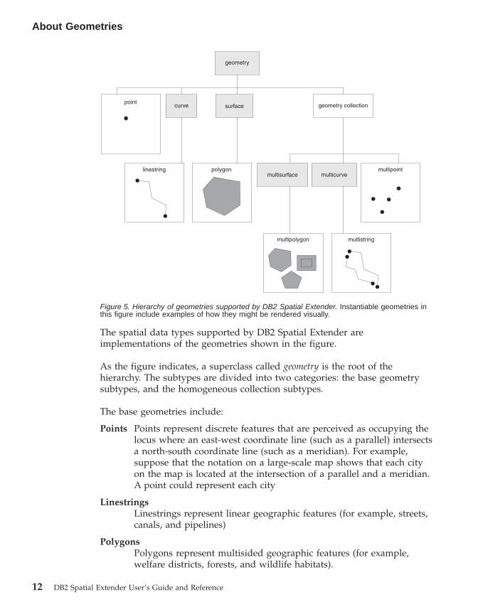
The spatial data types supported by DB2 Spatial Extender areimplementations of the geometries shown in the figure.
As the figure indicates, a superclass called geometry is the root of thehierarchy. The subtypes are divided into two categories: the base geometrysubtypes, and the homogeneous collection subtypes.
The base geometries include:
Points Points represent discrete features that are perceived as occupying thelocus where an east-west coordinate line (such as a parallel) intersectsa north-south coordinate line (such as a meridian). For example,suppose that the notation on a large-scale map shows that each cityon the map is located at the intersection of a parallel and a meridian.A point could represent each city
LinestringsLinestrings represent linear geographic features (for example, streets,canals, and pipelines)
PolygonsPolygons represent multisided geographic features (for example,welfare districts, forests, and wildlife habitats).
multistringmultipolygon
multisurfacemultipointlinestring polygon
pointcurve surface
geometry
geometry collection
multicurve
Figure 5. Hierarchy of geometries supported by DB2 Spatial Extender. Instantiable geometries inthis figure include examples of how they might be rendered visually.
About Geometries
12 DB2 Spatial Extender User’s Guide and Reference
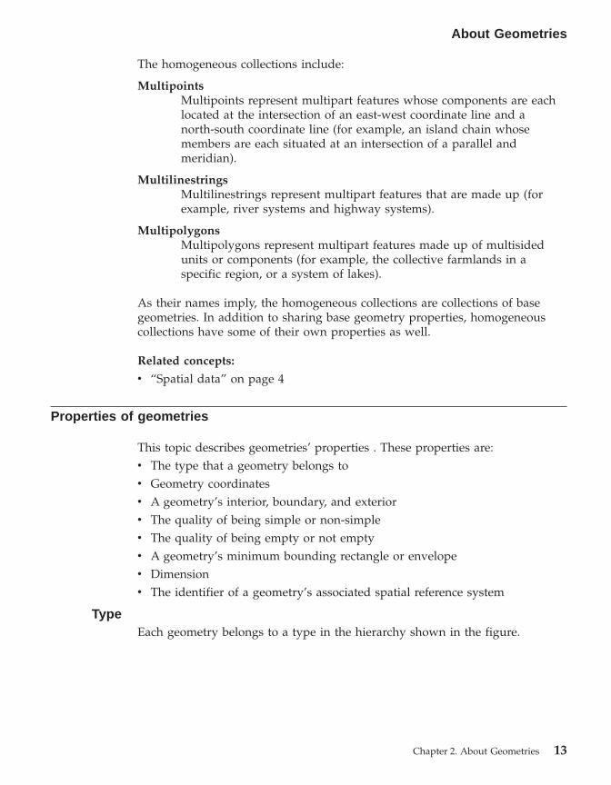
The homogeneous collections include:
MultipointsMultipoints represent multipart features whose components are eachlocated at the intersection of an east-west coordinate line and anorth-south coordinate line (for example, an island chain whosemembers are each situated at an intersection of a parallel andmeridian).
MultilinestringsMultilinestrings represent multipart features that are made up (forexample, river systems and highway systems).
MultipolygonsMultipolygons represent multipart features made up of multisidedunits or components (for example, the collective farmlands in aspecific region, or a system of lakes).
As their names imply, the homogeneous collections are collections of basegeometries. In addition to sharing base geometry properties, homogeneouscollections have some of their own properties as well.
Related concepts:
v “Spatial data” on page 4
Properties of geometries
This topic describes geometries’ properties . These properties are:v The type that a geometry belongs tov Geometry coordinatesv A geometry’s interior, boundary, and exteriorv The quality of being simple or non-simplev The quality of being empty or not emptyv A geometry’s minimum bounding rectangle or envelopev Dimensionv The identifier of a geometry’s associated spatial reference system
TypeEach geometry belongs to a type in the hierarchy shown in the figure.
About Geometries
Chapter 2. About Geometries 13

Seven types in the hierarchy—points, linestrings, polygons, geometrycollections, multipoints, multilinestrings, and multipolygons—are instantiable.The root type and other proper subtypes in the hierarchy are not instantiable.Additionally, users can define their own instantiable or not instantiable propersubtypes.
Geometry coordinatesAll geometries include at least one X coordinate and one Y coordinate, unlessthey are empty geometries in which they contain no coordinates at all. Inaddition, a geometry can include one or more Z coordinates and Mcoordinates. X, Y, Z, and M coordinates are represented as double precisionnumbers. The following subsections discuss:v X and Y coordinatesv Z coordinatesv M coordinates
X and Y coordinatesAn X coordinate value denotes a location that is relative to a point of referenceto the east or west. A Y coordinate value denotes a location that is relative to apoint of reference to the north or south.
multistringmultipolygon
multisurfacemultipointlinestring polygon
pointcurve surface
geometry
geometry collection
multicurve
Figure 6. Hierarchy of geometries supported by DB2 Spatial Extender. Instantiable geometries inthis figure include examples of how they might be rendered visually.
About Geometries
14 DB2 Spatial Extender User’s Guide and Reference
Z coordinatesSome geometries have an associated altitude or depth. Each of the points thatform the geometry of a feature can include an optional Z coordinate thatrepresents an altitude or depth normal to the earth’s surface.
M coordinatesAn M coordinate (measure) is a value that conveys information about ageographic feature and that is stored together with the coordinates that definethe feature’s location. For example, suppose that you are representinghighways in your GIS. If you want your application to process values thatdenote linear distances or mileposts, you can store these values along with thecoordinates that define locations along the highway. M coordinates arerepresented as double precision numbers.
Interior, boundary, and exteriorAll geometries occupy a position in space defined by their interior, boundary,and exterior. The exterior of a geometry is all space not occupied by thegeometry. The boundary of a geometry serves as the interface between itsinterior and exterior. The interior is the space occupied by the geometry.
Simple or non-simpleThe values of some geometry subtypes (linestrings, multipoints, andmultilinestrings) are either simple or non-simple. A geometry is simple if itobeys all the topological rules imposed on its subtype and non-simple if itdoesn’t. A linestring is simple if it does not intersect its interior. A multipointis simple if none of its elements occupy the same coordinate space. Points,surfaces, multisurfaces and empty geometries are always simple.
Empty or not emptyA geometry is empty if it does not have any points. The envelope, boundary,interior, and exterior of an empty geometry are not defined and will berepresented as null. An empty geometry is always simple. Empty polygonsand multipolygons have an area of 0.
Minimum bounding rectangle (MBR)The MBR of a geometry is the bounding geometry formed by the minimumand maximum (X,Y) coordinates. Except for the following special cases, theMBRs of geometries form a boundary rectangle:v The MBR of any point is the point itself, because its minimum and
maximum X coordinates are the same and its minimum and maximum Ycoordinates are the same.
v The MBR of a horizontal or vertical linestring is a linestring represented bythe boundary (the endpoints) of the source linestring.
DimensionA geometry can have a dimension of –1, 0, 1, or 2. The dimensions are listedas follows:
About Geometries
Chapter 2. About Geometries 15
—1 Is empty
0 Has no length and an area of 0 (zero)
1 Has a length larger than 0 (zero) and an area of 0 (zero)
2 Has an area that is larger than 0 (zero)
The point and multipoint subtypes have a dimension of zero. Points representdimensional features that can be modeled with a single tuple of coordinates,while multipoint subtypes represent data that must be modeled with a set ofpoints.
The subtypes linestring and multilinestring have a dimension of one. Theystore road segments, branching river systems and any other features that arelinear in nature.
Polygon and multipolygon subtypes have a dimension of two. Features whoseperimeter encloses a definable area, such as forests, parcels of land, and lakescan be represented by either the polygon or multipolygon data type.
Spatial reference system identifierThe numeric identifier for a spatial reference system determines which spatialreference system is used to represent the geometry.
All spatial reference systems known to the database can be accessed throughthe DB2GSE.ST_SPATIAL_REFERENCE_SYSTEMS catalog view.
About Geometries
16 DB2 Spatial Extender User’s Guide and Reference
Chapter 3. How to use DB2 Spatial Extender
How to use DB2 Spatial Extender
Support and use of DB2® Spatial Extender involves two main activities:setting up DB2 Spatial Extender and carrying out projects that use spatialdata. This chapter introduces the interfaces through which you can performthese activities and the tasks that you execute in the course of performingthem.
Interfaces to DB2 Spatial Extender and associated functionalitySeveral interfaces let you set up DB2 Spatial Extender and create projects thatuse spatial data. These interfaces are:v The DB2 Control Center windows, notebooks, and menu choices that
support DB2 Spatial Extender.v A command line processor (CLP) provided by DB2 Spatial Extender. It is
called the db2se CLP.
v Application programs that call DB2 Spatial Extender’s stored procedures.
Other interfaces let you generate spatial information. They include:v SQL queries that you submit from a DB2 CLP, from a query window in the
DB2 Control Center, or from an application program.v Visualization tools that render spatial information in graphical form. An
example is ArcExplorer Java, which was created by the EnvironmentalSystems Research Institute (ESRI) for IBM. ArcExplorer Java™ can bedownloaded from the DB2 Spatial Extender Web site.
Tasks that you perform to set up DB2 Spatial Extender and createprojects
This section provides an overview of the tasks you perform to set up DB2Spatial Extender and carry out projects that use spatial data. It includes ascenario that illustrates the tasks. The tasks fall into two categories:v Setting up DB2 Spatial Extenderv Creating projects that use spatial data
Setting up DB2 Spatial Extender:
This section lists the tasks that you perform to set up DB2 Spatial Extenderand uses a scenario to illustrate how a fictional company might approach eachtask.
© Copyright IBM Corp. 1998 - 2002 17

To set up DB2 Spatial Extender:
1. Plan and make preparations (decide what projects to create, decide whatinterface or interfaces to use, select personnel to administer DB2 SpatialExtender and create the projects, and so on).Scenario: The Safe Harbor Real Estate Insurance Company’s informationsystems environment includes a DB2 Universal Database™ system and aseparate file system for spatial data only. To an extent, query results caninclude combinations of data from both systems. For example, a DB2 tablestores information about revenue, and a file in the file system containslocations of the company’s branch offices. Therefore, it is possible to findout which offices bring in revenues of specified amounts, and then todetermine where these offices are located. But data from the two systemscannot be integrated (for example, users cannot join DB2 columns with filesystem records, and DB2 services such as query optimization areunavailable to the file system.) To overcome these disadvantages, SafeHarbor acquires DB2 Spatial Extender Version 8 and establishes a newSpatial Development department (called a Spatial department, for short).The Spatial department’s first mission is to include DB2 Spatial Extenderin Safe Harbor’s DB2 environment:v The department’s management team appoints a spatial administration
team to install and implement DB2 Spatial Extender, and a spatialanalysis team to generate and analyze spatial information.
v Because the administration team has a strong UNIX® background, itdecides to use the db2se CLP to administer DB2 Spatial Extender.
v Because Safe Harbor’s business decisions are driven primarily bycustomers’ requirements, the management team decides to install DB2Spatial Extender in the database that contains information about itscustomers. Most of this information is stored in a table calledCUSTOMERS.
2. Install DB2 Spatial Extender.Scenario: The spatial administration team installs DB2 Spatial Extender ona UNIX machine in a DB2 environment.
3. If you have DB2 Spatial Extender Version 7, migrate your spatial data toDB2 Version 8.Scenario: The Version 8 release is the first one that Safe Harbor hasacquired. No migration is needed.
4. Configure your database to accommodate spatial data. You adjustconfiguration parameters to ensure that your database has enoughmemory and space for spatial functions, log files, and DB2 SpatialExtender applications.
How to use DB2 Spatial Extender
18 DB2 Spatial Extender User’s Guide and Reference

Scenario: A member of the spatial administration team adjusts the UDFshared memory size, transaction log characteristics, application heap size,and application control heap size to values suited to DB2 SpatialExtender’s requirements.
5. Set up spatial resources for your database. These resources include asystem catalog, spatial data types, spatial functions, a geocoder, and otherobjects. The task of setting up these resources is referred to as enabling thedatabase for spatial operations.
The geocoder supplied by DB2 Spatial Extender translates United Statesaddresses into spatial data. It is called DB2SE_USA_GEOCODER.. Yourorganization and others can provide geocoders that translate addressesoutside the United States and other kinds of data into spatial data.Scenario: The spatial administration team sets up resources that will berequired by the projects that it is planning.v A member of the team issues a command to obtain the resources that
enable the database for spatial operations. These resources include theDB2 Spatial Extender catalog, spatial data types, spatial functions, andso on.
v Because Safe Harbor is starting to extend its business into Canada, thespatial administration team begins soliciting Canadian vendors forgeocoders that translate Canadian addresses into spatial data. SafeHarbor does not expect to acquire such geocoders for a few months yet.Therefore the first locations on which it will gather data will be in theUnited States.
Creating projects that use spatial data:
After you set up DB2 Spatial Extender, you are ready to undertake projectsthat use spatial data. This section lists the tasks involved in creating such aproject and continues the scenario in which the Safe Harbor Real EstateInsurance Company seeks to integrate business and spatial data.
To create a project that uses spatial data:
1. Plan and make preparations (set goals for the project, decide what tablesand data you need, determine what coordinate system or systems to use,and so on).Scenario: The Spatial department prepares to develop a project; forexample:v The management team sets these goals for the project:
– To determine where to establish new branch offices– To adjust premiums on the basis of customers’ proximity to
hazardous areas (areas with high rates of traffic accidents, areas withhigh rates of crime, flood zones, earthquake faults, and so on)
How to use DB2 Spatial Extender
Chapter 3. How to use DB2 Spatial Extender 19

v This particular project will be concerned with customers and offices inthe United States. Therefore, the spatial administration team decides to:– Use a coordinate system for the United States that DB2 Spatial
Extender provides. It is called GCS_NORTH_AMERICAN_1983.– Use DB2SE_USA_GEOCODER, because it is designed to geocode
United States addresses.v The spatial administration team decides what data is needed to meet the
project’s goals and what tables will contain this data.2. Create a coordinate system if you need to do so.
Scenario: Having decided to use GCS_NORTH_AMERICAN_1983, SafeHarbor can ignore this step.
3. Decide whether an existing spatial reference system meets your needs. Ifnone does, create one.A spatial reference system is a set of parameter values that includes:v Coordinates that define the maximum possible extent of space
referenced by a given range of coordinates. You need to determine themaximum possible range of coordinates that can be determined fromthe coordinate system that you are using, and to select or create aspatial reference system that reflects this range.
v The name of the coordinate system from which the coordinates arederived.
v Numbers used in mathematical operations to convert coordinatesreceived as input into values that can be processed with maximumefficiency. The coordinates are stored in their converted form andreturned to the user in their original form.
Scenario: DB2 Spatial Extender provides a spatial reference system,NAD83_SRS_1, that is designed to be used withGCS_NORTH_AMERICAN_1983. The spatial administration team decidesto use NAD83_SRS_1.
4. Create spatial columns, as needed. Note that in many cases, if data in aspatial column is to be read by a visualization tool, the column must bethe only spatial column in the table or view to which it belongs.Alternatively, if the column is one of multiple spatial columns in a table, itcould be included in a view that has no other spatial columns, andvisualization tools could read the data from this view.Scenario: The spatial administration team defines columns to containspatial data.v The team adds a LOCATION column to the CUSTOMERS table. The
table already contains customers’ addresses. DB2SE_USA_GEOCODERwill translate them into spatial data. Then DB2 will store this data in theLOCATION column.
How to use DB2 Spatial Extender
20 DB2 Spatial Extender User’s Guide and Reference
v The team creates an OFFICE_LOCATIONS table and an OFFICE_SALEStable to contain data that is now stored in the separate file system. Thisdata includes the addresses of Safe Harbor’s branch offices, spatial datathat was derived from these addresses by a geocoder, and spatial datathat defines a zone within a five-mile radius around each office. Thedata derived by the geocoder will go into a LOCATION column in theOFFICE_LOCATIONS table, and the data that defines the zones will gointo a SALES_AREA column in the OFFICE_SALES table.
5. Set up spatial columns for access by visualization tools, as needed. You dothis by registering the columns in the DB2 Spatial Extender catalog. Whenyou register a spatial column, DB2 Spatial Extender imposes a constraintthat all data in the column must belong to the same spatial referencesystem. This constraint enforces integrity of the data—a requirement ofmost visualization tools.Scenario: The spatial administration team expects to use visualizationtools to render the content of the LOCATION columns and theSALES_AREA column graphically on a map. Therefore, the team registersall three columns.
6. Populate spatial columns:For a project that requires spatial data to be imported, import the data.For a project that requires a geocoder:v Set, in advance, the control information needed when a geocoder is
invoked.v As an option, set up the geocoder to run automatically each time a new
address is added to the database, or an existing address is updated.
Run the geocoder in batch mode, as needed.
For a project that requires spatial data to be created by a spatial function,execute this function.
Scenario: The spatial administration team populates the CUSTOMERtable’s LOCATION column, the OFFICE_LOCATIONS table, theOFFICE_SALES table, and a new HAZARD_ZONES table:v The team uses DB2SE_USA_GEOCODER to geocode addresses in the
CUSTOMER table. The coordinates produced by the geocoding areinserted into the table’s LOCATION column.
v The team uses a utility to load office data from the filesystem into a file.Then the team imports this data to the new OFFICE_LOCATIONS table.
v The team creates a HAZARD_ZONES table, registers its spatialcolumns, and imports data to it. The data comes from a file supplied bya map vendor.
How to use DB2 Spatial Extender
Chapter 3. How to use DB2 Spatial Extender 21

7. Facilitate access to spatial columns, as needed. This involves definingindexes that enable DB2 to access spatial data quickly, and defining viewsthat enable users to retrieve interrelated data efficiently. If you wantvisualization tools to access the views’ spatial columns, you might need toregister these columns with DB2 Spatial Extender as well.Scenario: The spatial administration team creates indexes for the registeredcolumns. It then creates a view that joins columns from the CUSTOMERSand HAZARD ZONES tables. Next, it registers the spatial columns in thisview.
8. Generate spatial information and related business information. Analyze theinformation. This task involves querying spatial columns and relatednon-spatial columns. In such queries, you can include DB2 SpatialExtender functions that return a wide variety of information; for example,coordinates that define a proposed safety zone around a hazardous wastesite, or the minimum distance between this site and the nearest publicbuilding.Scenario: The spatial analysis team runs queries to obtain information thatwill help it meet the original goals: to determine where to establish newbranch offices, and to adjust premiums on the basis of customers’proximity to hazard areas.
Related concepts:
v “How to create spatial grid indexes” on page 106
Related tasks:
v “Setting up and configuring Spatial Extender” on page 27v “Enabling a database for spatial operations” on page 60v “Registering a geocoder” on page 62v “Configuring a database to accommodate spatial data” on page 53v “Importing shape data to a new or existing table” on page 91v “Importing SDE transfer data to a new or existing table” on page 92v “Setting up geocoding operations” on page 98v “Setting up a geocoder to run automatically” on page 101v “Running a geocoder in batch mode” on page 102v “Exporting data to an SDE transfer file” on page 95v “Selecting or creating coordinate systems” on page 73v “Selecting or creating spatial reference systems” on page 76v “Setting up spatial columns for access by visualization tools” on page 86v “Creating spatial columns” on page 86v “Calling DB2 Spatial Extender stored procedures from an application” on
page 132
How to use DB2 Spatial Extender
22 DB2 Spatial Extender User’s Guide and Reference

v “Including the DB2 Spatial Extender header file in spatial applications” onpage 131
Related reference:
v “Invoking commands for setting up DB2 Spatial Extender and developingprojects” on page 123
How to use DB2 Spatial Extender
Chapter 3. How to use DB2 Spatial Extender 23

How to use DB2 Spatial Extender
24 DB2 Spatial Extender User’s Guide and Reference

Part 2. Setting up DB2 Spatial Extender
© Copyright IBM Corp. 1998 - 2002 25

26 DB2 Spatial Extender User’s Guide and Reference

Chapter 4. Getting started with DB2 Spatial Extender
This chapter provides instructions for installing and configuring SpatialExtender for AIX, HP-UX, Windows NT, Window 2000, Linux, Linux forOS/390, and Solaris Operating Environments. This chapter also explains howto trouble shoot some of the installation and configuration problems that youmight encounter as you invoke Spatial Extender.
Setting up and configuring Spatial Extender—Steps
This section contains details for the following topics:v System requirements for installing Spatial Extenderv Installation instructions for UNIX and Windows platformsv Explanation on how to create a DB2 Spatial Extender instance environmentv Verifying the Spatial Extender installationv Troubleshooting tips for the installation sample program
Setting up and configuring Spatial Extender
A DB2 Spatial Extender system consists of DB2 Universal Database, DB2Spatial Extender, and, for most applications, a geobrowser. A geobrowser isnot required but is useful for visually rendering the results of spatial queries,generally in the form of maps. Databases enabled for spatial operations arelocated on the server. You can use client applications to access spatial datathrough the DB2 Spatial Extender stored procedures and spatial queries. Youcan also configure DB2 Spatial Extender in a stand-alone environment, whichis a configuration where both the client and server reside on the samemachine. In both client-server and stand-alone configurations, you can viewspatial data with a geobrowser such as ArcExplorer for DB2 or ESRI’s ArcGIStool suites running with ArcSDE.
You can download a free copy of ArcExplorer for DB2 from IBM’s DB2 SpatialExtender Web site at: http://www.ibm.com/software/data/spatial/.
DB2 Spatial Extender can be installed on: Windows, AIX , HP-UX, SolarisOperating Environment, Linux, and Linux for OS/390.
Prerequisites:
Before you set up DB2 Spatial Extender, you must have DB2 softwareinstalled and configured on the client and the server.
© Copyright IBM Corp. 1998 - 2002 27

Procedure:
To set up Spatial Extender:1. Ensure that your system meets all software requirements.2. Install Spatial Extender. The steps vary depending on your operating
system:v Windowsv AIXv HP-UXv Solaris Operating Environmentv Linux and Linux for OS/390Linux and Linux for OS/390
3. For UNIX platforms:Create a DB2 Spatial Extender instance environment.4. Verify the installation.Verify the installation.5. If necessary, see the troubleshooting tips and take appropriate actions to
correct any problems.
Related concepts:
v “System requirements for installing Spatial Extender” on page 28
Related tasks:
v “Installing DB2 Spatial Extender for Windows” on page 30v “Installing DB2 Spatial Extender for AIX” on page 32v “Installing DB2 Spatial Extender for HP-UX” on page 34v “Installing DB2 Spatial Extender for Solaris Operating Environment” on
page 36v “Installing DB2 Spatial Extender for Linux and Linux OS/390” on page 38v “Creating the DB2 Spatial Extender instance environment” on page 40v “Verifying the Spatial Extender installation” on page 42v “Troubleshooting tips for the installation sample program” on page 44v “Downloading ArcExplorer” on page 45
Related reference:
v “CD-ROMs for DB2 Spatial Extender data and maps” on page 47
System requirements for installing Spatial Extender
DB2® Spatial Extender can be installed on Windows, AIX, HP-UX, SolarisOperating Environment, Linux, and Linux for OS/390.
Before you install DB2 Spatial Extender, ensure that your system meets all thesoftware, and disk space requirements described below.
Getting started
28 DB2 Spatial Extender User’s Guide and Reference

Software requirements:
To install Spatial Extender, you must have the following DB2 softwareinstalled and configured on the server:
Server softwareDB2 Universal Database™ Enterprise Server Edition Version 8.1,DB2Universal Database Workgroup Server Edition Version 8.1, or DB2Universal Database Personal Edition Version 8.1. One of theseproducts must be installed on your system before you install DB2Spatial Extender. If you plan to use the DB2 Control Center, createand configure the DB2 Administration Server (DAS). For moreinformation on creating and configuring DAS, see the IBM® DB2Universal Database Administration Guide: Implementation.
Note: Although you can use DB2 Spatial Extender with the DB2Universal Database Enterprise Server Edition, the spatial indexcannot be partitioned across multiple nodes like in the massiveparallel processing (MPP) environment.
Note: The spatial client is included in the administration and applicationdevelopment client.
Disk space requirements:
To install Spatial Extender, your system must meet the disk spacerequirements listed in the following table.
Table 1. Disk space requirements for DB2 Spatial Extender
DB2 Spatial Extender software Disk space
Server software for DB2 Spatial Extender:
v Spatial Extender server library code,sample geocoder reference data, anddocumentation
v Optional and available on a separateCD-ROM: geocoder reference data(United States)
594 MB total disk space:
v 31 MB (DB2 Spatial Extender serverlibrary code, sample geocoderreference data, and documentation)
v 563 MB (United States geocoderreference data)
Table 1 specifies the disk space required when you install DB2 UniversalDatabase and DB2 Spatial Extender in a typical installation for Windows® orwith pre-selected components in AIX, HP-UX, Solaris Operating Enviroment,Linux, and Linux 390. If you are installing DB2 Spatial Extender or haveinstalled DB2 Universal Database with a different installation type, your diskspace calculations will differ.
Getting started
Chapter 4. Getting started with DB2 Spatial Extender 29

When your system meets all the software and disk space requirements, youcan install Spatial Extender.
Installing DB2 Spatial Extender for Windows
This task is part of the larger task of Setting up DB2 Spatial Extender.
You can install DB2 Spatial Extender on Windows operating systems by usingthe DB2 Setup wizard or a response file.
Recommendation: use the DB2 Setup wizard to install Spatial Extender. Thesetup wizard provides an easy-to-use graphical interface with installationhelp, automated user and group creation, protocol configuration, and instancecreation.
If you are using the DB2 Setup wizard to install Spatial Extender, you canclick Cancel at any point during the installation to exit the process.
Prerequisites:
Before you install the DB2 Spatial Extender product, you must have a DB2Version 8 server product installed.
Note: The Spatial Extender client and sample components are available in theDB2 client and server installs, so you do not need to have a DB2 serverif you just need Spatial client functionality.
Procedure:
To install Spatial Extender for Windows using the DB2 Setup wizard:1. Insert the Spatial Extender CD-ROM into the CD-ROM drive. The DB2
Setup Launchpad, an interface from which you can install DB2 SpatialExtender, opens.
2. Click Install products.3. Select DB2 Spatial Extender as the product you want to install and click
NEXT. The DB2 Setup wizard launches. Click NEXT. Use the DB2 Setupwizard to guide you through setup, and through the remaining installationsteps. At any time during the installation, you can click Help to launch theonline installation help.
To install Spatial Extender for Windows using the response file:1. Log on to the system with a user account that you want to use to perform
the installation.2. Insert the Spatial Extender CD-ROM. See the DB2 Installation and
Configuration Supplement for more information.
Getting started
30 DB2 Spatial Extender User’s Guide and Reference
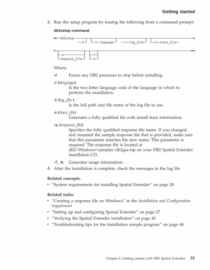
3. Run the setup program by issuing the following from a command prompt:
db2setup command
�� db2setup-f -i language -l log_file -t trace_file
�
�-uresponse_file
-?-h
��
Where:
-f Forces any DB2 processes to stop before installing.
-i (language)Is the two letter language code of the language in which toperform the installation.
-l (log_file )Is the full path and file name of the log file to use.
-t (trace_file)Generates a fully qualified file with install trace information.
-u (response_file)Specifies the fully qualified response file name. If you changedand renamed the sample response file that is provided, make surethat this parameter matches the new name. This parameter isrequired. The response file is located atdb2\Windows\samples\db2gse.rsp on your DB2 Spatial Extenderinstallation CD.
-?, -h Generates usage information.4. After the installation is complete, check the messages in the log file
Related concepts:
v “System requirements for installing Spatial Extender” on page 28
Related tasks:
v “Creating a response file on Windows” in the Installation and ConfigurationSupplement
v “Setting up and configuring Spatial Extender” on page 27v “Verifying the Spatial Extender installation” on page 42v “Troubleshooting tips for the installation sample program” on page 44
Getting started
Chapter 4. Getting started with DB2 Spatial Extender 31

Installing DB2 Spatial Extender for AIX
You can install DB2 Spatial Extender for AIX by using the DB2 Setup wizard,by using the db2_install script, or by using the System Management InterfaceTool (SMIT).
Recommendation: use the DB2 Setup wizard to install Spatial Extender. TheSetup wizard provides an easy-to-use graphical interface with installationhelp, automated user and group creation, protocol configuration, and instancecreation. If you choose not to use the wizard, you can install Spatial Extenderby using the db2_install script or by using AIX’s System ManagementInterface Tool (SMIT). Using SMIT to install Spatial Extender is onlyrecommended for advanced users in a situations where greater manualcontrol over the setup process is required.
Prerequisites:
Before you install Spatial Extender on AIX:v Ensure your system meets all software, memory, and disk space
requirements.v Update the kernel configuration parameters and restart the system for all
DB2 clients and servers on AIX.v You must have a DB2 Version 8 server product installed if you are installing
in a server or standalone environment.
Note: The DB2 Spatial Extender client and sample components areavailable in the DB2 client and server. If you just need spatial clientfunctionality, you do not need to install DB2 Spatial Extender.
v You must have root authority.
Procedure:
To install Spatial Extender using the DB2 Setup wizard:1. Log in as a user with root authority.2. Insert and mount the Spatial Extender CD-ROM. The DB2 Setup
Launchpad, an interface from which you can install DB2 Spatial Extender,opens. For information on how to mount a CD-ROM, see the DB2Installation and Configuration Supplement.
3. Select DB2 Spatial Extender as the product you want to install and clickNEXT.
4. The DB2 Setup wizard window opens. Use the DB2 Setup wizard to guideyou through setup, and through the remaining installation steps. At anytime during the installation, you can click Help to launch the onlineinstallation help.
Getting started
32 DB2 Spatial Extender User’s Guide and Reference

To install DB2 Spatial Extender using the db2_install script:1. Log in as a user with root authority.2. Insert and mount the appropriate CD-ROM.3. Enter the ./db2_install command to start the db2_install script. The
db2_install script can be found in the root directory on your DB2 Version 8product CD-ROM. The db2_install script prompts you for the productkeyword.
4. Type DB2.GSE to install DB2 Spatial Extender.
To install DB2 Spatial Extender using the System Management Interface Tool(SMIT):1. Log in as a user with root authority.2. Insert and mount the Spatial Extender CD-ROM.3. Enter the smit install_latest command.4. Type /cdrom/db2 in the INPUT device/directory for the software field.5. Click DO or press Enter to verify that the installation directory exists.6. In the Software to install field, identify whether the client or server
components are to be installed.
Note: Refer to the ComponentList.htm file on DB2 Spatial Extender CDfor a complete list of the components that you should install forDB2 Spatial Extender.
7. Click DO or press Enter. You are prompted to confirm the installationparameters.
8. Press Enter to confirm.9. Log out.
When the installation is complete, Spatial Extender will be installed in the/usr/opt/db2_08_01 directory along with your other DB2 products.
After you install Spatial Extender, create your DB2 instance environment ifyou did not already do so, and then verify the installation.
Related concepts:
v “System requirements for installing Spatial Extender” on page 28
Related tasks:
v “Installing a DB2 product on AIX using SMIT” in the Installation andConfiguration Supplement
v “Mounting the CD-ROM on AIX” in the Installation and ConfigurationSupplement
Getting started
Chapter 4. Getting started with DB2 Spatial Extender 33
v “Installing a DB2 product using the db2_install script” in the Installation andConfiguration Supplement
v “Verifying the Spatial Extender installation” on page 42v “Troubleshooting tips for the installation sample program” on page 44
Installing DB2 Spatial Extender for HP-UX
You can install Spatial Extender using the DB2® Setup wizard, by using thedb2_install script, or by using the swinstall command.
Recommendation: use the DB2 Setup wizard to install Spatial Extender. Thesetup wizard provides an easy-to-use graphical interface with installationhelp, automated user and group creation, protocol configuration, and instancecreation. If you choose not to use the wizard, you can install Spatial Extenderfor HP-UX by using the db2_install script or by using the swinstall command.Using the HP-UX swinstall command to install Spatial Extender is onlyrecommended for advanced users in situations where greater manual controlover the setup process is required.
Prerequisites:
Before you install the DB2 Spatial Extender product for HP-UX:v Ensure your system meets all hardware, software, and memory
requirements.v You must have a DB2 Version 8 server product installed.
Note: The DB2 Spatial Extender client and sample components areavailable in the DB2 client and server. If you just need spatial clientfunctionality, you do not need to install DB2 Spatial Extender.
v Update the kernel configuration parameters and restart the system for allDB2 clients and servers on HP-UX
v You must have root authority.
Procedure:
To install Spatial Extender for HP-UX using the DB2 Setup wizard:1. Insert and mount the DB2 Spatial Extender CD-ROM. The DB2 Setup
Launchpad, an interface from which you can install DB2 Spatial Extender,opens.
2. Select DB2 Spatial Extender as the product you want to install and clickNEXT. The DB2 Setup wizard launches. Click NEXT. Use the DB2 Setupwizard to guide you through setup, and through the remaining installationsteps. At any time during the installation, you can click Help to launch theonline installation help.
Getting started
34 DB2 Spatial Extender User’s Guide and Reference

To install Spatial Extender for HP-UX using the db2_install script:1. Log in as a user with root authority.2. Insert and mount the appropriate CD-ROM.3. Enter the ./db2_install command to start the db2_install script. The
db2_install script can be found in the root directory on your DB2 Version 8product CD-ROM. The db2_install script prompts you for the productkeyword.
4. Type DB2.GSE to install DB2 Spatial Extender.
To install Spatial Extender for HP-UX using the swinstall command:1. Log in as a user with root authority.2. Insert and mount the Spatial Extender CD-ROM.3. Run the swinstall program using the following command:
swinstall -x autoselect_dependencies=true
This command opens the Software Selection window and the SpecifySource window. If necessary, change the value in the Source host namefield in the Specify Source window.
4. In the Source Depot Path field enter /cdrom/db2/hpux where /cdromrepresents the CD-ROM mount directory.
5. Click OK to return to the Software Selection window. The SoftwareSelection window contains a list of available software to install.
6. Select the products you are licensed to install.7. Select Mark for Install from the Actions menu to choose the product to
be installed. A message appears:In addition to the software you just marked, other software wasautomatically marked to resolve dependencies. This message willnot appear again.
8. Select OK.9. Select Install (analysis) from the Actions menu to begin installing the
product and to open the Install Analysis window.10. Select OK in the Install Analysis window when the Status field displays
a Ready message.11. Select Yes in the Confirmation windows to confirm that you want to
install the software.View the Install window to read processing data while the software isbeing installed, until the Status field indicates Ready and the Notewindow opens. The swinstall program loads the file set, and runs thecontrol scripts for the file set.
12. Select Exit from the File menu to exit from swinstall.
Getting started
Chapter 4. Getting started with DB2 Spatial Extender 35
When the installation is complete, Spatial Extender will be installed in the/opt/IBM/db2/V8.1 directory along with your other DB2 products.
After you install Spatial Extender, create your DB2 instance environment ifyou did not already do so, and then verify the installation.
Related concepts:
v “System requirements for installing Spatial Extender” on page 28
Related tasks:
v “Installing a DB2 product on HP-UX using swinstall” in the Installation andConfiguration Supplement
v “Mounting the CD-ROM on HP-UX” in the Installation and ConfigurationSupplement
v “Installing a DB2 product using the db2_install script” in the Installation andConfiguration Supplement
v “Verifying the Spatial Extender installation” on page 42v “Troubleshooting tips for the installation sample program” on page 44
Installing DB2 Spatial Extender for Solaris Operating Environment
You can install Spatial Extender using the DB2® Setup wizard, by using thedb2_install script, or by using the pkgadd command.
Recommendation: use the DB2 Setup wizard to install DB2 Spatial Extender.The setup wizard provides an easy-to-use graphical interface with installationhelp, automated user and group creation, protocol configuration, and instancecreation. If you choose not to use the wizard, you can install Spatial Extenderusing the db2_install script or by using the Solaris Operating Environmentpkgadd command. Using the Solaris Operating Environment pkgaddcommand is only recommended for advanced users in situations wheregreater manual control over the setup process is required.
DB2 Spatial Extender is made up of different functions and components thatare referred to as packages in the Solaris environment. When you installSpatial Extender using the pkgadd command, you must install each requiredpackage and each associated package for the optional functions that you wantto use. The ComponentList.htm file on your DB2 Spatial Extender CD has acomplete list of the packages that you should install for DB2 Spatial Extender.The ComponentList.htm files is located in /cdrom/db2/solaris where /cdrom isthe mount point for your DB2 Spatial Extender CD-ROM.
Prerequisites:
Getting started
36 DB2 Spatial Extender User’s Guide and Reference
Before you install the DB2 Spatial Extender product for Solaris OperatingEnvironments:v Ensure your system meets all hardware, software, and memory
requirements.v You must have a DB2 Version 8 server product installed if you are installing
in a server or stand-alone environment.
Note: The DB2 Spatial Extender client and sample components areavailable in the DB2 client and server. If you just need spatial clientfunctionality, you do not need to install DB2 Spatial Extender.
v Update the kernel configuration parameters and restart the system for allDB2 clients and servers on Solaris.
v You must have root authority.
Procedure:
To install DB2 Spatial Extender for Solaris Operating Environments using theDB2 Setup wizard:1. Log in as a user with root authority.2. Insert and mount your DB2 Spatial Extender CD-ROM. The DB2 Setup
Launchpad, an interface from which you can install DB2 Spatial Extenderopens. For information on how to mount a CD-ROM, see DB2 for UNIXQuick Beginnings.
3. Select Spatial Extender as the product you want to install and click NEXT.4. The DB2 Setup wizard launches. Use the DB2 Setup wizard to guide you
through setup, and through the remaining installation steps. At any timeduring the installation, you can click HELP to launch the onlineinstallation help.
To install DB2 Spatial Extender using the db2_install script:1. Log in as a user with root authority.2. Insert and mount the appropriate CD-ROM.3. Enter the ./db2_install command to start the db2_install script. The
db2_install script can be found in the root directory on your DB2 Version 8product CD-ROM. The db2_install script prompts you for the productkeyword.
4. Type DB2.GSE to install DB2 Spatial Extender.
To install DB2 Spatial Extender for Solaris using the pkgadd command:1. Log in as a user with root authority.2. Insert and mount the DB2 Spatial Extender CD-ROM.
Getting started
Chapter 4. Getting started with DB2 Spatial Extender 37

3. Identify the required packages and optional packages that you want toinstall. See the ComponentList.htm file on your CD for a complete list ofthe components that you should install for DB2 Spatial Extender.
4. Run the pkgadd command for each package that you want to install bytyping:pkgadd package_name
Where package_name is the package that you want to install.
For example, if you want to install the Spatial Extender Base ServerSupport, you would need to install the db2gssg81 package by entering thefollowing command:pkgadd db2gssg81
When the installation is complete your Spatial Extender software will beinstalled in the /opt/IBM/db2/V8.1 directory.
After you install Spatial Extender, create your DB2 instance environment ifyou did not already do so, and then verify the installation.
Related concepts:
v “System requirements for installing Spatial Extender” on page 28
Related tasks:
v “Installing a DB2 product on Solaris using pkgadd” in the Installation andConfiguration Supplement
v “Mounting the CD-ROM on Solaris” in the Installation and ConfigurationSupplement
v “Installing a DB2 product using the db2_install script” in the Installation andConfiguration Supplement
v “Verifying the Spatial Extender installation” on page 42v “Troubleshooting tips for the installation sample program” on page 44
Installing DB2 Spatial Extender for Linux and Linux OS/390
You can install DB2 Spatial Extender for Linux and Linux OS/390 by usingthe DB2 Setup wizard, by using the db2_install script, or by using the rpmcommand.
Recommendation: use the DB2 Setup wizard to install Spatial Extender. Thesetup wizard provides an easy-to-use graphical interface with installationhelp, automated user and group creation, protocol configuration, and instancecreation. If you choose not to use the wizard, you can install Spatial Extenderby using the db2_install script or by using the rpm command. Using the
Getting started
38 DB2 Spatial Extender User’s Guide and Reference
Linux rpm command to install Spatial Extender is only recommended foradvanced users in situations where greater manual control over the setupprocess is required.
Prerequisites:
Before you install the DB2 Spatial Extender product for Linux and LinuxOS/390:v Ensure your system meets all hardware, software, and memory
requirements.v You must have a DB2 Version 8 server product installed if you are installing
in a server or stand alone environment.
Note: The DB2 Spatial Extender client and sample components areavailable in the DB2 client and server. If you just need spatial clientfunctionality, you do not need to install DB2 Spatial Extender.
v Update the kernel configuration parameters and restart the system for allDB2 clients and servers on HP-UX
v You must have root authority.
Procedure:
To install DB2 Spatial Extender using the DB2 Setup wizard:1. Log in as a user with root authority.2. Insert and mount your DB2 Spatial Extender CD-ROM. The DB2 Setup
Launchpad, an interface from which you can install DB2 Spatial Extenderopens. For information on how to mount a CD-ROM, see theDB2Installation and Configuration Supplement.
3. Click Install Products.4. Select Spatial Extender as the product you want to install and click NEXT.5. The DB2 Setup wizard window opens. Use the DB2 Setup wizard to guide
you through setup, and through the remaining installation steps. At anytime during the installation, you can click Help to launch the onlineinstallation help.
To install DB2 Spatial Extender using the db2_install script:1. Log in as a user with root authority.2. Insert and mount the appropriate CD-ROM.3. Enter the ./db2_install command to start the db2_install script. The
db2_install script can be found in the root directory on your DB2 Version 8product CD-ROM. The db2_install script prompts you for the productkeyword.
4. Type DB2.GSE to install DB2 Spatial Extender.
Getting started
Chapter 4. Getting started with DB2 Spatial Extender 39

To install Spatial Extender for Linux using the rpm command:1. Log in as a user with root authority.2. Enable your system for DB2 for Linux installation. See theDB2 Installation
and Configuration Supplement
3. Insert and mount the DB2 Spatial Extender CD-ROM.4. Identify the required packages and optional packages you want to install .
Note: Refer to the ComponentList.htm file on your DB2 Spatial ExtenderCD for a complete list of the components that you should install forDB2 Spatial Extender.
5. Run the rpm command for each package you want to install:rpm -ivh package_name
For example, if you want to install the server you would need to installthe IBM_db2gssg81-8.1.0-0.i386.rpm package by entering the followingcommand:rpm -IBM_db2gssg81-8.1.0-0.i386.rpm
When the installation is complete, Spatial Extender will be installed in the/opt/IBM/db2/V8.1 directory along with your other DB2 products.
After you install Spatial Extender, create your DB2 instance environment ifyou did not already do so, and then verify the installation.
Related concepts:
v “System requirements for installing Spatial Extender” on page 28
Related tasks:
v “Installing a DB2 product on Linux using rpm” in the Installation andConfiguration Supplement
v “Mounting the CD-ROM on Linux” in the Installation and ConfigurationSupplement
v “Installing a DB2 product using the db2_install script” in the Installation andConfiguration Supplement
v “Verifying the Spatial Extender installation” on page 42v “Troubleshooting tips for the installation sample program” on page 44
Creating the DB2 Spatial Extender instance environment
This task is part of the larger task of setting up Spatial Extender.
This section is only applicable for UNIX platforms.
Getting started
40 DB2 Spatial Extender User’s Guide and Reference
DB2 Spatial Extender can be used with any DB2 instance that is created afterinstalling the Spatial Extender code.
The db2icrt command is used to create new DB2 instances. All new DB2instances that you create after installing DB2 Spatial Extender include DB2Spatial Extender in the instance environment.
DB2 instances created before you install Spatial Extender do not include DB2Spatial Extender in their instance environments. To update existing DB2instances, use the db2iupdt command. If you are using the DB2 ControlCenter and created an instance for the DB2 Administration server prior toinstalling DB2 Spatial Extender, then you must update this instance.
Procedure:
To update an instance using the db2iupdt command:1. Log in as a user with root authority.2. Run the following command:
DB2DIR/instance/db2iupdt -a AuthType -u FencedID InstName
Where:
DB2DIRthe DB2 installation directory.v On AIX, the DB2 installation directory is /usr/opt/db2_08_01v On all other UNIX-based operating systems, the installation
directory is /opt/IBM/db2/V8.1
-a AuthTypeRepresents the authentication type for the instance. AuthType canbe one of SERVER, CLIENT, DCS, SERVER_ENCRYPT,DCS_ENCRYPT. SERVER is the default. This parameter is optional.
-u FencedIDRepresents the name of the user under which fenced user definedfunctions (UDFs) and fenced stored procedures will run. This flagis not required if you are creating an instance on a DB2 client.Specify the name of the fenced user you created.
InstNameRepresents the name of instance. The name of the instance must bethe same as the name of the instance owning user. Specify thename of the instance owning user you created. The instance willbe created in the instance owning user’s home directory.
To create an instance using db2icrt:1. Log in as user with root authority.
Getting started
Chapter 4. Getting started with DB2 Spatial Extender 41
2. Run the following command:DB2DIR/instance/db2icrt -a AuthType -u FencedID InstName
Where:
DB2DIRthe DB2 installation directory.v On AIX, the DB2 installation directory is /usr/opt/db2_08_01v On all other UNIX-based operating systems, the installation
directory is /opt/IBM/db2/V8.1
-a AuthTypeRepresents the authentication type for the instance. AuthType canbe one of SERVER, CLIENT, DCS, SERVER_ENCRYPT,DCS_ENCRYPT. SERVER is the default. This parameter is optional.
-u FencedIDRepresents the name of the user under which fenced user definedfunctions (UDFs) and fenced stored procedures will run. This flagis not required if you are creating an instance on a DB2 client.Specify the name of the fenced user you created.
InstNameRepresents the name of instance. The name of the instance must bethe same as the name of the instance owning user. Specify thename of the instance owning user you created. The instance willbe created in the instance owning user’s home directory.
For example, if you are using server authentication, your fenced user isdb2fenc1, and your instance owning user is db2inst1, use the followingcommand to create an instance on an AIX system:
/usr/opt/db2_08_01/instance/db2icrt -a server -u db2fenc1 db2inst1
After you create an instance you may want to configure notification for healthmonitoring. This task can be performed using the Health Center or CLP. Seethe DB2 Installation and Configuration Supplement for more information.
Verifying the Spatial Extender installation
This task is part of a larger task of setting up and configuring SpatialExtender.
After you install DB2 Spatial Extender, you can create a database and run theinstallation check program to verify that DB2 Spatial Extender is installed andconfigured correctly.
Getting started
42 DB2 Spatial Extender User’s Guide and Reference

You can verify the installation by using the DB2 Spatial Extender sampleprogram runGseDemo. The following verification steps apply to Windows,AIX, HP-UX, Solaris Operating Environments, Linux, and Linux 390,Operating systems.
Prerequisites:
For UNIX (AIX, HP-UX, Solaris Operating Environments, Linux, and Linux390) installations, check that you established the DB2 Spatial Extenderinstance environment before you run the installation check program. See theDB2 Installation and Configuration Supplement for information on how to runthe db2ilist program to check your instances.
Procedure:
To verify the installation:1. For UNIX only: Log on as the instance owner.2. Create a database. For example, type:
db2 create database mydb
where mydb is the database name.3. Locate the installation check program.
a. For UNIX operating systems type:cd $HOME/sqllib/samples/spatial
where $HOME is the instance owner’s home directory.b. For Windows type:
cd c:\Program Files\IBM\sqllib\samples\spatial
where c:\Program Files\IBM\sqllib is the directory in which youinstalled DB2 Spatial Extender.
4. Run the installation check program. For example type:runGseDemo mydb userID password
where mydb is the database name.
If you receive error messages during the verification process, you need totroubleshoot the installation.
Related tasks:
v “Troubleshooting tips for the installation sample program” on page 44v “Installing DB2 Spatial Extender for Windows” on page 30v “Installing DB2 Spatial Extender for AIX” on page 32
Getting started
Chapter 4. Getting started with DB2 Spatial Extender 43

v “Installing DB2 Spatial Extender for HP-UX” on page 34v “Installing DB2 Spatial Extender for Solaris Operating Environment” on
page 36v “Installing DB2 Spatial Extender for Linux and Linux OS/390” on page 38
Troubleshooting tips for the installation sample program
The runGseDemo sample program is designed to surface problems with yourinstallation. During the installation verification, you might receive errormessages that can help you diagnose specific system problems. Most of theerror messages are caused by a small number of typical problems. To avoidthese errors, ensure that you do the following task each time that you run theinstallation check program:v Be sure that you installed the DB2 Spatial Extender product in the
appropriate environments.v Use a new database that does not have any spatial operations associated
with it.v Increase the database configuration parameter value for application heap
size.
The remainder of this section lists the typical problem areas to check whenyou troubleshoot.
Database is already spatially enabled
Check that the database for which you are verifying the installation isnew and has no spatial operations associated with it; if it does, thesample program will fail.
You will receive the following error message if the database you arerunning the sample program against is already spatially enabled:Enabling database logtst...Returning from ENABLE_DB:Return code = -14Return message text =GSE0014E The database has already been enabled for spatial operations.
To fix this problem, drop the database and repeat the steps inVerifying the Spatial Extender installation.
Database manager configuration parameter value for application heap size
If APPLHEAPSZ is not set at adequate value, you’ll get this errormessage while enabling database for spatial operations:GSE0213N A bind operation failed.SQLERROR = "SQL0001N Binding or precompilationdid not complete successfully.SQLSTATE=00000".SQLSTATE=57011
Getting started
44 DB2 Spatial Extender User’s Guide and Reference

To increas the database configuration parameter value for theapplication heap size, type:db2 update db cfg for database_name using APPLHEAPSZ 2048
If 2048 is inadequate, increase the APPLHEAPSZ parameter inincrements of 256.
Post-Installation considerations
After you install Spatial Extender, consider the following:v Downloading ArcExplorerv Accessing geocoder reference data
Downloading ArcExplorer
IBM provides a browser, produced by Environmental Systems ResearchInstitute (ESRI)for IBM, that can directly produce visual results of queries ofDB2 Spatial Extender data without requiring a intermediate data server. Thisbrowser is ArcExplorer for DB2. You can download a free copy of ArcExplorerfrom IBM’s Spatial Extender Web site athttp://www.ibm.com/software/data/spatial/.
For more information on installing and using ArcExplorer, see theUsingArcExplorer book, which is also available as part of the ArcExplorer productdownload on the DB2 Spatial Extender Web site.
Important: DB2 Universal Database Version 8.1 is shipped with IBM JavaDevelopment Kit (JDK) Version 1.3.1. When you install JREArcExplorer, place it in a separate directory from DB2. Rememberto set the CLASSPATH environment variable.
Related tasks:
v “Setting up and configuring Spatial Extender” on page 27
Accessing geocoder reference data
The geocoder reference data on the DB2 Spatial Extender Geocoder ReferenceData CD-ROM is created specifically to work with a geocoder supplied bySpatial Extender. It is composed of USA base map street network data that theDB2SE_USA geocoder uses to determine the coordinates of addresses in aspatially enabled database. This base-map data is collectively called referencedata. The DB2SE_USA geocoder takes address data (non-spatial) in yourdatabase, compares and matches it with the reference data, and converts itinto coordinates that can be stored by DB2 Spatial Extender. This process iscalled geocoding.
Getting started
Chapter 4. Getting started with DB2 Spatial Extender 45

The reference data provided on the CD-ROM includes the EDGELocator.locfile. The EDGELocator.loc file is used by the DB2SE_USA geocoder to locatespecific reference data. For example, if you are geocoding addresses inCalifornia, Kentucky, and Oregon, the DB2SE_USA geocoder uses the locatorfile on the CD-ROM to determine the address locations .
Procedure:
You can access the geocoder data directly from the CD-ROM, or you can copythe data to your hard drive. To copy geocoder data files from the CD-ROM toyour DB2 Spatial Extender server environment, perform the steps explained inthis section.
For UNIX operating systems:1. Mount the CD-ROM. For information on how to mount a CD-ROM, see
DB2 for UNIX Quick Beginnings.2. Log in at the target server machine as a user with root authority.3. Type the following command:
v For AIX:cp /cdrom/db2/* /usr/opt/db2_08_01/gse/refdata/
v For all other UNIX platforms:cp /cdrom/db2/* /0pt/IBM/db2/V8.1/gse/refdata/
Note: You can copy geocoder data files into any directory on your localdrive. If you choose to copy the files into a directory that youspecify , you must modify the locator file to point to the newlocation.
4. Log out.
For Windows, you can use either the Command window or WindowsExplorer.
To use the Command window to access geocoder data:1. Click Start –> Program –> IBM DB2 –> Command Window.2. Type the following command:
copy d:\db2\* %db2path%\gse\refdata
where d: is the letter that corresponds to your CD-ROM drive.
Note: You can copy geocoder data files into any directory on your localdrive. If you choose to copy the files into a directory that youspecify , you must modify the locator file to point to the newlocation.
Getting started
46 DB2 Spatial Extender User’s Guide and Reference

To use the Windows Explorer to access geocoder data:
Copy all the files from d:\db2 to c:\Program Files\IBM\sqllib\gse\refdata,where d: is the CD-ROM drive and c:\Program Files\IBM\sqllib is the directorywhere DB2 is installed.
Related tasks:
v “Setting up and configuring Spatial Extender” on page 27
CD-ROMs for DB2 Spatial Extender data and maps
DB2 Spatial Extender is shipped with seven data and maps CD-ROMs.
The data and maps information, labeled DB2 Spatial Extender Data and Maps1 – 7, is provided on seven CD-ROMs. The following table provides asummary of the data located on each CD-ROM.
Table 2. Data and maps CD-ROM information
Data and Maps CD-ROM Type of map data summary
CD-ROM 1 Europe and World
CD-ROM 2 Canada, Mexico and United States
CD-ROM 3 United States
CD-ROM 4 United States (western region)
CD-ROM 5 United States (central region)
CD-ROM 6 United States (eastern region)
CD-ROM 7 United States (southern region)
For a detailed description of the data provided by ESRI, see the ESRI help file,esridata.hlp, located on the DB2 Spatial Extender Data and Maps CD-ROM.v For Windows, view the help file in x: esridata.hlp, where x: is the CD-ROM
drive.v For UNIX operating systems, view or print the help file located on the
CD-ROM in /cdrom/esridata.hlp , where /cdrom is your mount point.
Getting started
Chapter 4. Getting started with DB2 Spatial Extender 47

Getting started
48 DB2 Spatial Extender User’s Guide and Reference
Chapter 5. Migrating the Spatial Extender environment toDB2 Universal Database Version 8
This section explains how you migrate DB2 Spatial Extender from Version 7 toVersion 8. It also explains how you use the migration utility to migrate from a32-bit environment to a 64-bit environment.
Migrating a spatially-enabled database
If you have been using DB2 Spatial Extender Version 7, you must completethe following steps before using an existing spatially-enabled database withDB2 Spatial Extender Version 8. This topic describes the steps required tomigrate spatially-enabled databases from a previous version of DB2 SpatialExtender.
Prerequisites:
v Terminate all connections to the database before you run the migrationutility.
v Before you start the migration process, ensure that your system meets theinstallation requirements for DB2 Spatial Extender Version 8.
v To backup a database, you must have SYSADM, SYSCTRL, or SYSMAINTauthority for the database.
v To migrate a database, you must have SYSADM authority.
Procedure:
To migrate the DB2 Spatial Extender environment:1. Backup your Version 7 database. For information on how to backup your
database, see DB2 Installation and Configuration Supplement.2. Install DB2 Universal Database Version 8 and DB2 Spatial Extender
Version 8.3. Migrate your DB2 instance and databases from Version 7 to Version 8. For
more information on how to migrate your DB2 instance and databases, seeDB2 Installation and Configuration Supplement
4. Migrate a spatially-enabled database from Version 7 to Version 8 using theSpatial Extender migration utility.a. From an operating system command prompt, type the following
command:
© Copyright IBM Corp. 1998 - 2002 49

db2se migrate database command
�� db2se migrate database_name—userId user_id —pw password
�
�—tableCreationParameters table_creation_parameters
�
�—force force_value —messagesFile messages_filename
��
Where:
-database_nameThe name of the database to be migrated.
-user_IdThe database user ID which has either SYSADM or DBADMauthority on the database that is being migrated.
-passwordYour user password.
-table_creation_parametersThe parameters to be used in the creation of the SpatialExtender catalog tables.
-force_value
v 0: Attempt migration but stop if any application-definedobjects such as views, functions, or triggers have been basedon Spatial Extender objects.
v 1: Saves and restores spatial indexes.v 2: Automatically saves and restores application-defined
objects. Saves spatial index information but does notautomatically restore spatial indexes.
-messages_filenameThe file name containing the report of migration actions. Themessages_file must be a fully qualified file name on the server.
Migrating from a 32–bit to a 64–bit environmentIf you have spatial indexes that were created in a 32–bit environment and youwant to migrate to a 64 bit environment, complete the following steps.
Note: 64-bit Windows and Linux servers are supported for testing efforts1. Backup your database.2. Save the spatial indexes that are defined by typing the following from an
operating system command prompt:
Migrating
50 DB2 Spatial Extender User’s Guide and Reference
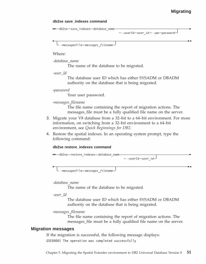
db2se save_indexes command
�� db2se save_indexes database_name—userId user_id —pw password
�
�—messagesFile messages_filename
��
Where:
-database_nameThe name of the database to be migrated.
-user_IdThe database user ID which has either SYSADM or DBADMauthority on the database that is being migrated.
-passwordYour user password.
-messages_filenameThe file name containing the report of migration actions. Themessages_file must be a fully qualified file name on the server.
3. Migrate your V8 database from a 32–bit to a 64–bit environment. For moreinformation, on switching from a 32–bit environment to a 64–bitenvironment, see Quick Beginnings for DB2.
4. Restore the spatial indexes. In an operating system prompt, type thefollowing command:
db2se restore_indexes command
�� db2se restore_indexes database_name—userId user_id
�
�—messagesFile messages_filename
��
-database_nameThe name of the database to be migrated.
-user_IdThe database user ID which has either SYSADM or DBADMauthority on the database that is being migrated.
-messages_filenameThe file name containing the report of migration actions. Themessages_file must be a fully qualified file name on the server.
Migration messagesIf the migration is successful, the following message displays:GSE0000I The operation was completed successfully
Migrating
Chapter 5. Migrating the Spatial Extender environment to DB2 Universal Database Version 8 51

If the migration is not successful, the following message displays:GSE9002N An error occurred during an attempt to performSpatial Extender database migration.
Note: The following errors may occur during migration:v Database is not currently spatially enabled.v Database is not a Version 7 spatially-enabled databasev Database is already a Version 8 spatially-enabled databasev Database name is not validv Other connections to the database exist. Can not be run.v Spatial catalog is not consistent.v User is not authorizedv Password is not validv Some user objects could not be migrated
Be sure to check the messages files for details on the error(s) you may receive.The message file also contains useful information such as indexes, views, andthe geocoding setup that was migrated.
Related tasks:
v “Backing up databases before DB2 migration” in the Quick Beginnings forDB2 Servers
v “Migrating databases” in the Quick Beginnings for DB2 Servers
v “Migrating instances (UNIX)” in the Quick Beginnings for DB2 Servers
v “Migrating DB2 (Windows)” in the Quick Beginnings for DB2 Servers
v “Migrating DB2 (UNIX)” in the Quick Beginnings for DB2 Servers
v “Migrating DB2 Personal Edition (Windows)” in the Quick Beginnings forDB2 Personal Edition
v “Migrating DB2 Personal Edition (Linux)” in the Quick Beginnings for DB2Personal Edition
v “Migrating databases on DB2 Personal Edition (Windows)” in the QuickBeginnings for DB2 Personal Edition
v “Migrating instances and databases on DB2 Personal Edition (Linux)” in theQuick Beginnings for DB2 Personal Edition
Migrating
52 DB2 Spatial Extender User’s Guide and Reference
Chapter 6. Setting up a database
This chapter discusses how to configure a database to accommodate spatialdata.
Configuring a database to accommodate spatial data
DB2 Spatial Extender, which runs in the DB2 Universal Database environment,works with most default DB2 configuration values. However, severalconfiguration parameters affect spatial operations. You must tune theseparameters so that your spatial applications perform as efficiently as possible.In certain cases, choosing a value other than the default value is required forspatial operations. In other cases, doing so is recommended, depending onyour applications and your overall DB2 environment. This chapter identifiesthe DB2 configuration parameters that influence the operations of DB2 SpatialExtender.
The following sections explain how to tune the DB2 database manager anddatabase configuration parameters that affect DB2 Spatial Extender operations.
Tuning the database configuration parameters
Several database configuration parameters affect spatial applications. Tomodify any database configuration parameter, you must be connected to thedatabase. When you modify the values of these parameters for a database, thechange affects only that database. The following sections explain how to tunethe parameters for spatial applications:v “Tuning transaction log characteristics”v “Tuning the application heap size” on page 55v “Tuning the application control heap size” on page 56
Tuning transaction log characteristicsBefore you enable a database for spatial operations, ensure that you haveenough transaction log capacity. The default values for the transaction logconfiguration parameters do not provide sufficient transaction log capacity ifyour plans include:v Enabling a database for spatial operations in a Windows environmentv Using the ST_import_shape stored procedure to import from shape filesv Using geocoding with a large commit scopev Running concurrent transactions
© Copyright IBM Corp. 1998 - 2002 53

If your plans include any of these uses now or in the future, you need toincrease the capacity of your transaction log for the database by increasingone or more of the transaction log configuration parameters. Otherwise, youcan use the default characteristics. In this case, proceed to “Tuning theapplication heap size” on page 55.
Recommendation: Refer to the following table for the recommendedminimum values for the three transaction log configuration parameters.
Table 3. Recommended minimum values for transaction configuration parameters
Parameter Description Default valueRecommendedminimum value
LOGFILSZ Specifies the log filesize as a number of4-KB blocks
1000 1000
LOGPRIMARY Specifies how manyprimary log files areto be preallocated tothe recovery logfiles
3 10
LOGSECOND Specifies thenumber ofsecondary log files
2 2
If the capacity of your transaction log is inadequate, the following errormessage is issued when you try to enable a database for spatial operations:GSE0010N Not enough log space is available to DB2.
Procedure:
To increase the value of one or more configuration parameters:1. Find the current value for the LOGFILSIZ, LOGPRIMARY, and
LOGSECOND parameters by reviewing the output from the GETDATABASE CONFIGURATION command or from the ConfigureDatabase window of the DB2 Control Center.
2. Decide whether to change one, two, or three of the values as indicated inthe table above.
3. Change each value that you want to modify. You can change the values byissuing one or more of the following commands, where db_name identifiesyour database:
UPDATE DATABASE CONFIGURATION FOR db_name USING LOGFILSZ 1000
Setting up a database
54 DB2 Spatial Extender User’s Guide and Reference

UPDATE DATABASE CONFIGURATION FOR db_name USING LOGPRIMARY 10
UPDATE DATABASE CONFIGURATION FOR db_name USING LOGSECOND 2
If the only parameter that you change is LOGSECOND, the change takeseffect immediately. In this case, proceed to “Tuning the application heapsize”.
4. If you change the LOGFILSIZ or LOGPRIMARY parameter, or both:a. Disconnect all applications from the database.b. If the database was explicitly activated, deactivate the database.
The changes to the LOGFILSIZ or LOGPRIMARY parameters, or both,take effect the next time either the database is activated or a connection tothe database is established.
Tuning the application heap sizeYou use the database configuration parameter APPLHEAPSZ to specify thesize of the application heap (in number of 4-KB pages). This parameterdefines the number of private memory pages that are available for use by thedatabase manager on behalf of a specific agent or subagent. The heap isallocated when an agent or subagent is initialized for an application. Theallocated amount is the minimum amount that is needed to process therequest to the agent or subagent. As the agent or subagent requires more heapspace to process larger SQL statements, the database manager allocatesmemory as needed, up to the maximum that is specified on this parameter.The application heap is allocated out of the agent’s private memory.
The default value for the APPLHEAPSZ parameter is 128 (4-KB pages). Whenyou run the ST_enable_db stored procedure, this value must be at least 2048.
Recommendation: For most DB2 Spatial Extender applications, especiallythose that import from or export to shape files, use an APPLHEAPSZparameter value of at least 2048.
If the APPLHEAPSZ is set to an inadequate value, the following errormessage is issued when you try to enable a database for spatial operations:GSE0009N Not enough space is available in DB2’s application heap.
GSE0213N A bind operation failed. SQLERROR = "SQL0001N Binding orprecompilation did not complete successfully. SQLSTATE=00000".
Procedure:
To change the application heap size:1. Find the current value for the APPLHEAPSZ parameter by reviewing the
output from the GET DATABASE CONFIGURATION command or fromthe Configure Database window of the DB2 Control Center.
Setting up a database
Chapter 6. Setting up a database 55

2. Change the value to the recommended value of 2048 or to a larger value.You can change the value to 2048 by issuing the following command,where db_name identifies your database:UPDATE DATABASE CONFIGURATION FOR db_name USING APPLHEAPSZ 2048
3. Disconnect all applications from the database.4. If the database was explicitly activated, deactivate the database.
The change takes effect the next time either the database is activated or aconnection to the database is established.
Tuning the application control heap sizeAll DB2 Spatial Extender applications, especially those that import from orexport to shape files, can benefit from using the recommended value for theapplication control heap size. You specify this characteristic with theAPP_CTL_HEAP_SZ parameter. This parameter specifies the maximum size,in 4-KB pages, for the application control shared memory. Application controlheaps are allocated from this shared memory. One application control heap isallocated for each application at the database where the application is active(or, in the case of a partitioned database system, at each database partitionwhere the application is active). The heap is allocated during connectprocessing by the first agent that receives a request for the application at thedatabase (or at the database partition). The heap is used for sharinginformation between agents that work on behalf of the same application. (In apartitioned database environment, the sharing occurs at the database partitionlevel; sharing does not occur across database partitions.) The default value forthe APP_CTL_HEAP_SZ parameter is 128.
Recommendation: For most DB2 Spatial Extender applications, use anAPP_CTL_HEAP_SZ parameter value of at least 1024 (4-KB pages).
If the APP_CTL_HEAP_SZ is set to an inadequate value, the following errormessage is issued when you import data into a database from shape files:GSE0214N An INSERT statement failed. SQLERROR = "SQL0973N Not enough storageis available in the "APP_CTL_HEAP" heap to process the statement.
Procedure:
To change the application control heap size:1. Find the current value for the APP_CTL_HEAP_SZ parameter by
reviewing the output from the GET DATABASE CONFIGURATIONcommand or from the Configure Database window of the DB2 ControlCenter.
2. Change the value to the recommended value of 1024 (4-KB pages) or to alarger value. You can issue the following command, where db_nameidentifies your database:
Setting up a database
56 DB2 Spatial Extender User’s Guide and Reference

UPDATE DATABASE CONFIGURATION FOR db_name USING APP_CTL_HEAP_SZ 1024
3. Disconnect all applications from the database.4. If the database was explicitly activated, deactivate the database.
The change takes effect the next time either the database is activated or aconnection to the database is established.
Setting up a database
Chapter 6. Setting up a database 57

Setting up a database
58 DB2 Spatial Extender User’s Guide and Reference
Chapter 7. Setting up spatial resources for a database
After you set up your database to accommodate spatial data, you are ready tosupply the database with resources that you will need when you create andmanage spatial columns and analyze spatial data. These resources include:v Objects provided by Spatial Extender to support spatial operations; for
example, stored procedures to administrate a database, spatial data types,and spatial utilities for geocoding and importing or exporting spatial data.
v Reference data: Ranges of addresses that DB2SE_USA_GEOCODER uses toconvert individual addresses to coordinates.
v Any geocoders that users or vendors provide.
This chapter describes these resources and introduces the tasks through whichyou make them available: enabling your database for spatial operations,setting up access to reference data, and registering non-default gecoders.
How to set up resources in your database
The first task that you perform after setting up your database to accommodatespatial data is to render the database capable of supporting spatialoperations—operations such as populating tables with spatial data andprocessing spatial queries. This task involves loading the database withcertain resources supplied by DB2 Spatial Extender. This section describesthese resources and outlines the task.
Inventory of resources supplied for your database
To enable a database to support spatial operations, DB2® Spatial Extenderprovides the database with the following resources:v Stored procedures. When you request a spatial operation—for example,
when you issue a command to import spatial data—DB2 Spatial Extenderinvokes one of these stored procedures to perform the operation.
v Spatial data types. You must assign a spatial data type to each table or viewcolumn that is to contain spatial data.
v DB2 Spatial Extender’s catalog. Certain operations depend on this catalog.For example, before you can access a spatial column from the visualizationtools, the tool may require that the spatial column be registered in thecatalog.
v A spatial grid index. It lets you to define grid indexes on spatial columns.
© Copyright IBM Corp. 1998 - 2002 59

v Spatial functions. You use these to work with spatial data in a number ofways; for example, to determine relationships between geometries and togenerate more spatial data.
v Definitions of coordinate systems.v Default spatial reference systems.v Two schemas: DB2GSE and ST_INFORMTN_SCHEMA. DB2GSE contains
the objects just listed: stored procedures, spatial data types, the DB2 SpatialExtender catalog, and so on. Views in the catalog are available also inST_INFORMTN_SCHEMA to conform with the SQL/MM standard..
Enabling a database for spatial operations
The task of having DB2 Spatial Extender supply a database with resources forcreating spatial columns and manipulating spatial data is generally referred toas “enabling the database for spatial operations”.
Prerequisite:
Before you enable a database for spatial operations, your user ID must haveeither SYSADM or DBADM authority on the database.
Restrictions:
You can only use data types created by the enable_db command.
Procedure:
You can enable a database for spatial operations in any of the following ways:v Use the Enable Database window from the DB2 Spatial Extender menu
option. The menu option is available from the database object of the DB2Control Center.
v Issue the db2se enable_db command.v Run an application that calls the db2gse!ST_enable_db stored procedure.
Note:
You can explicitly choose the table space in which you want the DB2Spatial Extender catalog to reside. If you do not do so, DB2 will use thedefault table space.
Related concepts:
v “Inventory of resources supplied for your database” on page 59
Related tasks:
Setting up spatial resources for a database
60 DB2 Spatial Extender User’s Guide and Reference

v “Writing applications for DB2 Spatial Extender” on page 131
Related reference:
v “Invoking commands for setting up DB2 Spatial Extender and developingprojects” on page 123
v “ST_enable_db” on page 191
How to work with reference data
This section explains what reference data is and states what you need to do inorder to access it.
Reference data
Reference data is range of addresses that DB2SE_USA_GEOCODER uses toconvert individual addresses into coordinates. This data consists of ranges ofthe most recent addresses that the United States Census Bureau has collected.When DB2SE_USA_GEOCODER reads an address from the database, itsearches the reference data for:v Names of certain streets within the area designated by the address’s zip
code. The geocoder looks for names that match the name of the street in theaddress to a specified degree, or to a degree higher than the specified one;for example, 80 percent or higher.
v The address range that corresponds to the address number.
If a match is found and does not have the requested score, the geocoderreturns the coordinates of the address it has read. If a match is not found ordoes not have the requested score, the geocoder returns a null.
An advanced configuration file called the locator file can be used to furtherinfluence the processing performed by the geocoder,DB2SE_USA_GEOCODER. The default configuration provided by DB2®
Spatial Extender usually does not not need to be changed in this file.
Setting up access to reference data
The reference data for DB2SE_USA_GEOCODER is on one of the CD-ROMson which Spatial Extender is shipped. This section describes how to prepareto access it.
Procedure:
To prepare to access the default geocoder’s reference data:1. Decide whether to keep the reference data on the CD-ROM or to store it
on your hard drive. If you keep it on the CD-ROM, then you save thespace (about 700 megabytes’ worth) that it would occupy on the hard
Setting up spatial resources for a database
Chapter 7. Setting up spatial resources for a database 61

drive. If you store it on hard drive, you will be able to retrieve it fasterthan you can retrieve it from the CD-ROM.
2. If you want to store the reference data on your hard drive:a. Verify that the hard drive has enough space to contain the data (about
700 megabytes).b. Copy the data to the hard drive. For instructions, see the README
that accompanies the reference data.c. Determine whether the copy was successful: To verify on UNIX that
the data was loaded properly, look for it in the$DB2INSTANCE/sqllib/gse/refdata/ directory. To verify on WindowsNT that the data was loaded properly, look for it in the%DB2PATH%\gse\refdata\ directory.
3. Tell DB2SE_USA_GEOCODER the name and location of the locator fileand the base map. You do this by setting DB2SE_USA_GEOCODER’sbase_map and locator_file parameters to the appropriate values. For moreinformation, see your database administrator or contact your IBMrepresentative.
Registering a geocoder
DB2SE_USA_GEOCODER is registered to DB2 Spatial Extender automaticallywhen a database is enabled for spatial operations. Before other geocoders canbe used, they also must be registered.
Prerequisite:
Before you can register a geocoder, your user ID must hold either SYSADM orDBADM authority on the database in which the geocoder resides.
Procedure:
You can register a geocoder in any of the following ways:v Register it from the Register Geocoder window of the DB2 Control Center.v Issue the db2se register_gc command.v Run an application that calls the db2gse.ST_register_geocoder stored
procedure.
Related concepts:
v “Geocoders and geocoding” on page 96
Setting up spatial resources for a database
62 DB2 Spatial Extender User’s Guide and Reference
Part 3. Creating projects that use spatial data
© Copyright IBM Corp. 1998 - 2002 63

64 DB2 Spatial Extender User’s Guide and Reference
Chapter 8. Setting up spatial resources for a project
After your database is enabled for spatial operations, you are ready to createprojects that use spatial data. Among the resources that each project requiresare a coordinate system to which spatial data conforms and a spatial referencesystem that defines the extent of the geographical area that is referenced bythe data. This chapter:v Discusses the nature of coordinate systems and tells how to create themv Explains what spatial reference systems are and tells how to create them
How to use coordinate systems
When you plan a project that uses spatial data, you need to determinewhether the data should be based on one of the coordinate systems that areregistered to the Spatial Extender catalog. If none of these coordinate systemsmeet your requirements, you can create one that does. This discussionexplains the concept of coordinate systems and introduces the tasks ofselecting one to use and creating a new one.
Coordinate systems
A coordinate system is a conceptual tool for defining the relative locations ofthings in a given area; for example, an area on the earth’s surface or theearth’s surface as a whole. DB2® Spatial Extender supports two types ofcoordinate systems, geographic and projected, to determine the location of ageographic feature. A geographic coordinate system is a grid system that uses athree-dimensional spherical surface to determine locations for a given area onthe earth. Any location on earth can be referenced by a point where the grid’shorizontal and vertical lines intersect. The values for the points can bemeasured in radians; in degrees, minutes, and seconds (DMS); or in decimaldegrees.
Figure 7 on page 66 shows a geographic coordinate system.
© Copyright IBM Corp. 1998 - 2002 65
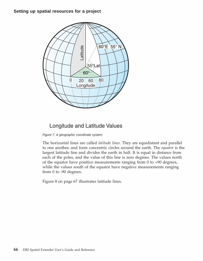
The horizontal lines are called latitude lines. They are equidistant and parallelto one another, and form concentric circles around the earth. The equator is thelargest latitude line and divides the earth in half. It is equal in distance fromeach of the poles, and the value of this line is zero degrees. The values northof the equator have positive measurements ranging from 0 to +90 degrees,while the values south of the equator have negative measurements rangingfrom 0 to -90 degrees.
Figure 8 on page 67 illustrates latitude lines.
60°E 55° N
Latit
ude
20 60 80Longitude
Longitude and Latitude Values
0
55°Lat.
60°
Figure 7. A geographic coordinate system
Setting up spatial resources for a project
66 DB2 Spatial Extender User’s Guide and Reference

The vertical lines are called longitude lines, and are often referred to asmeridians. They form circles of the same size around the earth, and intersect atthe poles. The prime meridian is the line of longitude that defines the origin(zero degrees) for longitude coordinates. One of the most commonly usedprime meridian locations is the line that passes through Greenwich, England.However, there are also longitude lines that pass through Bern, Bogota, andParis that can be used as the prime meridian. The values east of the primemeridian have positive measurements ranging from 0 to +180 degrees, whilethe values west of the prime meridian have negative measurements rangingfrom 0 to -180 degrees.
Figure 9 on page 68 illustrates longitude lines.
Parallels(Lines of latitude)
Equator
Figure 8. Latitude lines
Setting up spatial resources for a project
Chapter 8. Setting up spatial resources for a project 67

The latitude and longitude lines encompass the globe to form a griddednetwork called a graticule. The point of origin of the graticule is (0,0), wherethe equator and the prime meridian intersect. The equator is the only place onthe graticule where the linear distance of one degree latitude is approximatelyequal to one degree longitude. Because the longitude lines converge at thepoles, the distance between each meridian is different at every parallel.Therefore, as you move closer to the poles, the difference between one degreelatitude will be much greater than one degree longitude. It is also difficult todetermine the lengths of the latitude lines using the graticule. The latitudelines are concentric circles that become smaller near the poles. They form asingle point at the poles where the meridians begin. At the equator, onedegree of longitude is approximately 111.321 km; while at 60 degrees oflatitude, one degree of longitude is only 55.802 km. This approximation isbased on the Clarke 1866 spheroid. Therefore, because there is no uniformlength of degrees of latitude and longitude, the distances of the points cannotbe measured accurately by using angular units of measure.
Figure 10 on page 69 shows the different dimensions between locations on thegraticule.
Meridians(Lines of longitude)
Primemeridian
Figure 9. Longitude lines
Setting up spatial resources for a project
68 DB2 Spatial Extender User’s Guide and Reference

A coordinate system can be defined by either a sphere or a spheroidapproximation of the earth’s shape. Because the earth is not perfectly round, aspheroid can help maintain accuracy for large-scale maps. A spheroid is anellipsoid, that is based on an ellipse, whereas a sphere is based on a circle. Asphere can be used for small-scale maps, because the differences between thetwo representations of the earth are virtually undetectable on a map of a smallarea. The shape of the ellipse is determined by two radii. The longer radius iscalled the semimajor axis, and the shorter radius is called the semiminor axis.
Figure 11 on page 70 shows the sphere and spheroid approximations of theearth.
111.321KM
Graticularnetwork
55.802KM
(one degree of longitudeat the equator)
(one degree of longitudeat latitude)60°
Figure 10. Different dimensions between locations on the graticule
Setting up spatial resources for a project
Chapter 8. Setting up spatial resources for a project 69
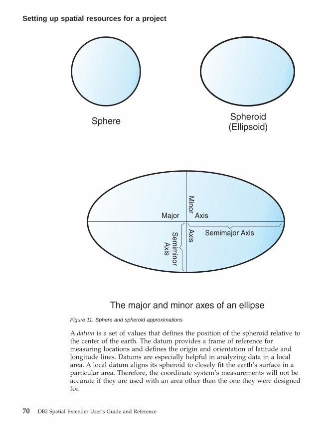
A datum is a set of values that defines the position of the spheroid relative tothe center of the earth. The datum provides a frame of reference formeasuring locations and defines the origin and orientation of latitude andlongitude lines. Datums are especially helpful in analyzing data in a localarea. A local datum aligns its spheroid to closely fit the earth’s surface in aparticular area. Therefore, the coordinate system’s measurements will not beaccurate if they are used with an area other than the one they were designedfor.
Sphere Spheroid(Ellipsoid)
Major Axis
Semimajor AxisSem
iminor
Axis
Minor A
xis
The major and minor axes of an ellipseFigure 11. Sphere and spheroid approximations
Setting up spatial resources for a project
70 DB2 Spatial Extender User’s Guide and Reference

Figure 12 shows how different datums align with the earth’s surface.
Whenever you change the datum, the geographic coordinate system is alteredand the coordinate values will change. For example, the coordinates in DMSof a control point in Redlands, California using the North American Datum of1983 (NAD 1983) are: "-117 12 57.75961 34 01 43.77884" The coordinates of thesame point on the North American Datum of 1927 (NAD 1927) are: "-117 1254.61539 34 01 43.72995" .
A projected coordinate system is a flat, two-dimensional grid representation ofthe earth. It is based on a sphere or spheroid geographic coordinate system,but it uses linear units of measure for coordinates, so that calculations ofdistance and area can be in terms of units such as feet or meters. The latitudeand longitude coordinates are converted to x, y coordinates on the flatprojection. The x coordinate represents the horizontal location of a point, andthe y coordinate represents the vertical location of a point. The horizontal linein the center of the grid is referred to as the x axis, and the vertical line in thecenter of the grid is referred to as the y axis. The intersection of these twoaxes is the origin and has a coordinate of (0,0). The values above the x axisare positive, and the values below the x axis are negative. The horizontal linesof the grid are equidistant and are parallel to the x axis. The values to theright of the y axis are positive, and the values to the left of the y axis arenegative. The vertical lines of the grid are equidistant and parallel to the yaxis.
Earth's surfaceEarth-centered (WGS84) datumLocal (NAD27) datum
Local geographiccoordinate system
Earth-centered geographiccoordinate system
Figure 12. Datum alignments
Setting up spatial resources for a project
Chapter 8. Setting up spatial resources for a project 71

Mathematical formulas are used to convert a three-dimensional geographiccoordinate system to a two-dimensional flat projected coordinate system. Thetransformation is referred to as a map projection. Map projections usually areclassified by the projection surface used, such as conic, cylindrical, and planarsurfaces. Depending on the projection used, different spatial properties willappear distorted. Projections are designed to minimize the distortion of one ortwo of the data’s characteristics, yet the distance, area, shape, direction, or acombination of these properties might not be accurate representations of thedata that is being modeled. There are several types projections available.While most map projections attempt to preserve some accuracy of the spatialproperties, there are others that attempt to minimize overall distortion instead,such as the Robinson projection. The most common types of map projectionsinclude:
Equal area projectionsThese projections preserve the area of specific features. Theseprojections distort shape, angle, and scale. The Albers Equal Area Conicprojection is an example of an equal area projection.
Conformal projectionsThese projections preserve local shape for small areas. Theseprojections preserve individual angles to describe spatial relationshipsby showing perpendicular graticule lines that intersect at 90 degreeangles on the map. All of the angles are preserved; however, the areaof the map is distorted. The Mecator and Lambert Conformal Conicprojections are examples of conformal projections.
Equidistant projectionsThese projections preserve the distances between certain points bymaintaining the scale of a given data set. Some of the distances willbe true distances, which are the same distances at the same scale asthe globe. If you go outside the data set, the scale will become moredistorted. The Sinusoidal projection and the Equidistant Conic projectionare examples of equidistant projections.
True-direction or azimuthal projectionsThese projections preserve the direction from one point to all otherpoints by maintaining some of the great circle arcs. These projectionsgive the directions or azimuths of all points on the map correctly withrespect to the center. Azimuthal maps can be combined with equalarea, conformal, and equidistant projections. The Lambert Equal AreaAzimuthal projection and the Azimuthal Equidistant projection areexamples of azimuthal projections.
Setting up spatial resources for a project
72 DB2 Spatial Extender User’s Guide and Reference

Selecting or creating coordinate systems
After you enable a database for spatial operations, you are ready to planprojects that use spatial data. A first step in planning a project is to determinewhat coordinate system to use. Your options are as follows:v You can use a coordinate system that was shipped with DB2 Spatial
Extender or one that was created by a user. Over 2000 coordinate systemsare shipped with DB2 Spatial Extender. Among them are:– A coordinate system that DB2 Spatial Extender refers to as
“Unspecified.” Use this coordinate system when:- You need to define locations that have no direct relationship to the
earth’s surface; for example, locations of offices within an officebuilding or locations of shelves within a storage room.
- You can define these locations in terms of positive coordinates thatinclude few or no decimal values.
– GCS_NORTH_AMERICAN_1983. Use this coordinate system when youneed to define locations in the United States; for example:- When you import spatial data for the United States from the “Maps
and Data” CDs that are shipped with DB2 Spatial Extender.- When you plan to use the geocoder shipped with DB2 Spatial
Extender to geocode addresses within the United States
To find out more about these coordinate systems, and to determine whatother coordinate systems were shipped with DB2 Spatial Extender, andwhat (if any) coordinate systems have been created by other users, consultthe DB2SE.ST_COORDINATE_SYSTEMS catalog view.
v You can create a coordinate system.
Prerequisites:
Before you create a coordinate system, your user ID must have eitherSYSADM or DBADM authority on the database that has been enabled forspatial operations. No authorization is required to use an existing coordinatesystem.
Procedure:
You can create a coordinate system in any of the following ways:v Create it from the Create Coordinate System window of the DB2 Control
Center.v Issue the db2se create_cs command from the db2se command line
processor.
Setting up spatial resources for a project
Chapter 8. Setting up spatial resources for a project 73
v Run an application that invokes the db2se.ST_create_coordsys storedprocedure.
Related concepts:
v “Coordinate systems” on page 65
Related tasks:
v “Writing applications for DB2 Spatial Extender” on page 131
Related reference:
v “Invoking commands for setting up DB2 Spatial Extender and developingprojects” on page 123
v “ST_create_coordsys” on page 172
How to set up spatial reference systems
When you plan a project that uses spatial data, you need to determinewhether any of the spatial reference systems available to you can be used forthis data. If none of the available systems are appropriate for the data, youcan create one that is. This section explains the concept of spatial referencesystems and describes the tasks of selecting which one to use and creatingone.
About spatial reference systems
A spatial reference system is a set of parameter values that includes:v Coordinates that define the maximum possible extent of space that is
referenced by a given range of coordinates.v The name of the coordinate system from which the coordinates are derived.v Numbers that, when applied in certain mathematical operations, convert
coordinates received as input into values that can be processed withmaximum efficiency.
The following sections discuss the first and third subsets of parameter valuescited in the preceding list: those that define a maximum extent of space andthose that are used as conversion factors.
Defining the space that encompasses coordinates stored in a spatialcolumn:
The coordinates in a spatial column typically define locations that span acrosspart of the earth. The space over which the span extends—from east to westand from north to south—is called a spatial extent. For example, consider abody of flood plains whose coordinates are stored in a spatial column.Suppose that the westernmost and easternmost of these coordinates are
Setting up spatial resources for a project
74 DB2 Spatial Extender User’s Guide and Reference

latitude values of –24.556 and –19.338, respectively, and that the northernmostand southernmost of the coordinates are longitude values of 18.819 and 15.809degrees, respectively. The spatial extent of the flood plains is a space thatextends on a west-east plane between the two latitudes and on a north-southplane between the two longitudes. You can include these values in a spatialreference system by assigning them to certain parameters. If the spatialcolumn includes Z coordinates and measures, you would need to include thehighest and lowest Z coordinates and measures in the spatial reference systemas well.
The term spatial extent can refer not only to an actual span of locations, as inthe previous paragraph; but also to a potential one. Suppose that the floodplains in the preceding example were expected to broaden over the next fiveyears. You could estimate what the westernmost, easternmost, northernmost,and southernmost coordinates of the planes would be at the end of the fifthyear. You could then assign these estimates, rather than the currentcoordinates, to the parameters for a spatial extent. That way, you could retainthe spatial reference system as the plains expand and their wider latitudesand longitudes are added to the spatial column. Otherwise, if the spatialreference system is limited to the original latitudes and longitudes, it wouldneed to be altered or replaced as the flood planes grew.
Converting to values that improve performance:
Typically, most coordinates in a coordinate system are decimal values; someare integers. In addition, coordinates to the east of the origin are positive;those to the west are negative. Before being stored by Spatial Extender, thenegative coordinates are converted to positive values, and the decimalcoordinates are converted into integers. As a result, all coordinates are storedby Spatial Extender as positive integers. The purpose is to enhanceperformance when the coordinates are processed.
Certain parameter values in a spatial reference system are used to effect theconversions described in the preceding paragraph. One type of value, calledan offset, is subtracted from each negative coordinate, leaving a positive valueas a remainder. Each decimal coordinate is multiplied by another type ofvalue, called a scale factor, resulting in an integer whose precision is the sameas that of the decimal coordinate. (The offset is subtracted from positivecoordinates as well as negative; and the non-decimal coordinates, as well asthe decimal coordinates, are multiplied by the scale factor. This way, allpositive and non-decimal coordinates remain commensurate with the negativeand decimal ones.)
The aforementioned conversions take place internally, and remain in effectonly until coordinates are retrieved. Input and query results always containcoordinates in their original, unconverted form.
Setting up spatial resources for a project
Chapter 8. Setting up spatial resources for a project 75

Selecting or creating spatial reference systems
After you determine what coordinate system to use, you are ready to providea spatial reference system for your data. Your options are as follows:v You can use a spatial reference system that was shipped with DB2 Spatial
Extender or one that was created by a user. Some of the spatial referencesystems shipped with DB2 Spatial Extender are:– A default spatial reference system. Its name is “DEFAULT_SRS.” Use this
system when you use the Unspecified coordinate system.– A spatial reference system that you can use when you use the coordinate
system that DB2 Spatial Extender provides for addresses in the UnitedStates (GCS_NORTH_AMERICAN_1983). This spatial reference system’sname is “NAD83_SRS_1” and its numeric identifier is 1. It is advisable touse NAD83_SRS_1 when you want to use the geocoder or the UnitedStates sample data that are shipped with DB2 Spatial Extender.
To find out more about these spatial reference systems, and to determine ifspatial reference systems are available to you, consult theDB2SE.ST_SPATIAL_REFERENCE_SYSTEMS catalog view.
v You can create a spatial reference system. There are two ways to do this:– Determine and specify the extent of the geographical area that your
spatial data defines, as well as the degree of accuracy that you want thedata to have. If you are new to spatial reference systems, you might findthis method to be the faster of the two.
– Determine and specify all the factors that DB2 Spatial Extender requiresto convert negative values and decimal values to positive values andintegers. You might prefer this method if you are accustomed to creatingspatial reference systems. However, this section offers a “fast-track”approach that might appeal to all users. The following section describesthis approach. The sections that follow the next one describe the longermethods.
Tip: Use the longer methods when the largest coordinate multiplied bythe scale factor is greater than the largest positive integer or whenyou need to follow strict criteria for accuracy and precision.
Prerequisites:
There are no prerequisites for using an existing spatial reference system or forcreating one.
Restrictions:
Setting up spatial resources for a project
76 DB2 Spatial Extender User’s Guide and Reference

When you create a spatial reference system, select an offset and scale factorthat, when applied against spatial data, result in integers that are less thantwice the value of the largest possible integer in your original spatial data.
Fast-track procedure for creating a spatial reference system:
If you are working with decimal-degress, the following values will supportthe full range of latitude-longitude coordinates and preserve 6 decimalpositions, equivalent to approximately 100 cm. Note that all the data on theDB2 Spatial Extender sample data CDs is in decimal-degrees.
xOffset = –180yOffset = –90xyScale = 1000000zOffset = 0zScale = 1mOffset = 0
In addition to the values just listed, you need to specify the coordinate systemfor the data that you are working with.
If you are working with positive coordinates, all offset values can be set to 0.If the coordinates are integers, the scale factors can be set to 1. If thecoordinates are decimal values, the scale factor should be set to a number thatconverts the decimal portion to an integer value. For example, if thecoordinate units are meters and the accuracy of the data is 1 cm., you wouldneed a scale factor of 100.
Procedure for creating a spatial reference system by determining andspecifying the extent of geographical area:
A description of this procedure follows. The description begins with anoverview of the steps in the procedure and concludes with details of eachstep.
Overview of steps:
1. Determine the highest coordinate and the lowest coordinate among thecoordinates of the locations that you want to represent. If your data is toinclude measures, determine the highest and lowest of these measures.
2. Optional but recommended: Indicate to DB2 Spatial Extender that theextent that encompasses the locations that you are concerned with is largerthan it actually is. Consequently, after you populate a spatial column withthe coordinates for these locations, you can update the column withcoordinates for locations of new features as they are added to the outerreaches of the extent. Otherwise, if you want to update the column with
Setting up spatial resources for a project
Chapter 8. Setting up spatial resources for a project 77

coordinates that lie beyond the extent defined by the spatial referencesystem, you need to supply a spatial reference system that defines a largerextent. Replacing one spatial reference system with another can be acomplex and time-consuming task.
3. If any of the coordinates that define the locations that you are representingare decimal numbers, or if any measures associated with these coordinatesare decimal numbers, determine what scale factors to use. These are valuesthat, when multiplied by decimal coordinates and measures, yield integerswhose precision is at least the same as that of the coordinates andmeasures.
4. Create the spatial reference system that you want.
Details of steps:
1. To determine the highest and lowest coordinates of the locations that youare interested in, and to determine the highest and lowest measures tostore with your spatial data, answer the following questionsv Is the easternmost location in your domain defined by a single pair or
by multiple pairs of X and Y coordinates? If it is defined by a singlepair, what is the X coordinate? If it is defined by multiple pairs, what isthe easternmost X coordinate in these pairs? (The answer to bothquestions is the highest X coordinate.) For example, if you arerepresenting oil wells, and each one is defined by a pair of X and Ycoordinates, what X coordinate indicates the location of the oil well thatis furthest east?
v Is the westernmost location in your domain defined by a single pair orby multiple pairs of X and Y coordinates? If it is defined by a singlepair, what is the X coordinate? If it is defined by multiple pairs, what isthe westernmost X coordinate in these pairs? (The answer to bothquestions is the lowest X coordinate. If the location lies to the west ofthe point of origin, this coordinate will be a negative value.)
v Is the northernmost location in your domain defined by a single pair orby multiple pairs of X and Y coordinates? If it is defined by a singlepair, what is the Y coordinate? If it is defined by multiple pairs, what isthe northernmost Y coordinate in these pairs? (The answer to bothquestions is the highest Y coordinate.)
v Is the southernmost location in your domain defined by a single pair orby multiple pairs of X and Y coordinates? If it is defined by a singlepair, what is the Y coordinate? If it is defined by multiple pairs, what isthe southernmost Y coordinate in these pairs? (The answer to bothquestions is the lowest Y coordinate. If the location lies to the south ofthe point of origin, this coordinate will be a negative value.)
v Are the heights and depths of the locations defined by Z coordinates? Ifso, what Z coordinate defines the greatest of the heights? What Zcoordinate defines the greatest of the depths?
Setting up spatial resources for a project
78 DB2 Spatial Extender User’s Guide and Reference

v If you are going to include measures in your spatial data, whichmeasure has the highest numerical value? Which has the lowest?
2. If you want to indicate to DB2 Spatial Extender that the domain thatencompasses the locations that you are concerned with is larger than itactually is, proceed as follows:To each coordinate and measure that you identified in Step 1, add anamount equal to five to ten percent of the coordinate or measure. Theresult is referred to in this discussion as an augmented value. For example,if the lowest negative X coordinate is –100, you could add –5 to it, yieldingan augmented value of –105. Later, when you define the spatial referencesystem, you will indicate that the lowest X coordinate is –105, rather thanthe true value of –100. DB2 Spatial Extender will then interpret –105 as thewesternmost limit of your data’s extent.
3. If any of the coordinates that define the locations that you are representingare decimal numbers, or if any measures associated with these coordinatesare decimal numbers, determine what scale factors to use.Specify a scale factor that, when multiplied by a decimal X coordinate or adecimal Y coordinate, yields a 32-bit integer. It is advisable to make thisscale factor a factor of 10: 10 to the first power (10), 10 to the secondpower (100), 10 to the third power (1000), or, if necessary, a larger factor.To decide what factor of 10 the scale factor should be:a. Determine which X and Y coordinates are, or are likely to be, decimal
numbers. For example, suppose that of the various X and Ycoordinates that you will be dealing with, you determine that three ofthem are decimal numbers: 1.23, 5.1235, and 6.789.
b. Take the decimal coordinate that has the longest decimal precision.Then determine by what factor of 10 this coordinate can be multipliedin order to yield an integer of equal precision. To illustrate: of the threedecimal coordinates in the current example, 5.1235 has the longestdecimal precision. Multiplying it by 10 to the fourth power (10000)would yield the integer, 51235.
c. Determine whether the integer produced by the multiplication that wasjust described is too long to store as a 32-bit data item. 51235 is not toolong. But suppose that in addition to 1.23, 5.11235, and 6.789, yourrange of X and Y coordinates includes a fourth decimal value,10006.789876. Because this coordinate’s decimal precision is longer thanthat of the other three, you would multiply this coordinate—not5.1235—by a factor of 10. To convert it to an integer, you couldmultiply it by 10 to the sixth power (1000000). But the resulting value,10006789876, is too long to store as a 32-bit data item. If DB2 SpatialExtender tried to store it, the results would be unpredictable.To avoid this problem, select a factor of 10 that, when multiplied bythe original coordinate, yields a decimal number that DB2 SpatialExtender can truncate to a storable integer, with minimum loss of
Setting up spatial resources for a project
Chapter 8. Setting up spatial resources for a project 79
precision. In this case, you could select 10 to the fourth power (10000).Multiplying 10000 by 10006.789876 yields 100067898.76. DB2 SpatialExtender would truncate this number to 100067898, reducing itsaccuracy by a virtually insignificant amount.
4. Create the spatial reference system that you want. As you do so, you willspecify augmented values and scale factors that you determined in thepreceding steps.You can create a spatial reference system in any of the following ways:v Create it from the – window of the Control Center.v Issue the db2se create_srs command from the db2se command line
processor.v Run an application that invokes the db2se.ST_create_srs stored
procedure.
For information about how to proceed, consult the sources that are listedunder “Related tasks” at the end of this discussion.
Full procedure for creating a spatial reference system by determining andspecifying all conversion factors:
1. Determine the lowest negative coordinates within the range of coordinatesfor the locations that you want to represent. If your data is to includenegative measures, determine the lowest of these measures. For guidelineson performing this step, see the methods for determining lowestcoordinates and measures in step 1 on page 78
2. Optional but recommended: Indicate to DB2 Spatial Extender that thedomain that encompasses the locations that you are concerned with islarger than it actually is. Consequently, after you write data about theselocations to a spatial column, you can augment the column with dataabout locations of new features as they are added to outer reaches of thedomain, without your having to replace your spatial reference system withanother one.To perform this step, proceed as follows: To each coordinate and measurethat you identified in Step 1, add an amount equal to five to ten percent ofthe coordinate or measure. The result, as noted in 77, is referred to in thisdiscussion as an augmented value.For example, if the lowest negative X coordinate is –100, you could add –5to it, yielding an augmented value of –105. Later, when you define thespatial reference system, you will indicate that the lowest X coordinate is–105, rather than the true value of –100. DB2 Spatial Extender will theninterpret –105 as the westernmost limit of your domain.
3. Determine what offset factors (or offsets, for short) to use. These are valuesthat, when subtracted from negative coordinates and measures, leavepositive numbers.
Setting up spatial resources for a project
80 DB2 Spatial Extender User’s Guide and Reference
To perform this step, proceed as follows:v After you decide what you want your augmented X value to be, specify
an offset that, when subtracted from this value, leaves zero. DB2 SpatialExtender will then subtract this number from all negative X coordinatesto arrive at a positive value. DB2 Spatial Extender will subtract thisnumber from all other X coordinates as well.For example, if the augmented X value is –105, you need to subtract–105 from it to get 0. DB2 Spatial Extender will then subtract –105 fromall X coordinates that are associated with the features that you arerepresenting. Because none of these coordinates is greater than –100, allthe values that result from the subtraction will be positive.
v Similarly, specify offsets that leave 0 when subtracted from theaugmented Y value, the augmented Z value, and the augmentedmeasure.
4. If any of the coordinates for the locations that you are representing aredecimal numbers, determine what scale factors to use. For guidelines onperforming this step, see step 3 on page 79.
5. Define the spatial reference system that you want to DB2 Spatial Extender.As you do so, you will specify the augmented values, offsets, and scalefactors that you arrived at in preceding steps.You can create a spatial reference system in any of the following ways:v Create it from the Create Spatial Reference System window of the DB2
Control Center.v Issue the db2se create_srs command from the db2se command line
processor.v Run an application that invokes the db2se.ST_create_srs stored
procedure.
For information about how to proceed, consult the sources that are listedunder “Related tasks” at the end of this discussion.
Note about selecting scale factors that preserve precision:
When you invoke a spatial function that takes as input a decimal coordinateor measure and the identifier of a spatial reference system, the functionmultiplies the decimal coordinate or measure by a scale factor within thesystem. The result is an integer that DB2 Spatial Extender stores. The scalefactor needs to be large enough to ensure that the precision of this integer isthe same as the precision of the decimal coordinate.
For example, suppose that the ST_Point function is given input that consistsof an X coordinate 10.01, a Y coordinate of 20.03, and the identifier of a spatialreference system. When ST_Point is invoked, it multiplies the value of 10.01and the value of 20.03 by the spatial reference system’s scale factor for X and
Setting up spatial resources for a project
Chapter 8. Setting up spatial resources for a project 81

Y coordinates. If this scale factor is 10, the resulting integers that DB2 SpatialExtender stores will be 100 and 200, respectively. Because the precision ofthese integers (3) is less than the precision of the coordinates (4), DB2 SpatialExtender will not be able to convert these integers back to the originalcoordinates, or to derive from them values that are consistent with thecoordinate system to which these coordinates belong. But if the scale factor is100, the resulting integers that DB2 Spatial Extender stores will be 1001 and2003—values that can be converted back to the original coordinates or fromwhich compatible coordinates can be derived.
Related concepts:
v “About spatial reference systems” on page 74
Related tasks:
v “Writing applications for DB2 Spatial Extender” on page 131
Related reference:
v “Invoking commands for setting up DB2 Spatial Extender and developingprojects” on page 123
v “ST_create_srs” on page 174
Setting up spatial resources for a project
82 DB2 Spatial Extender User’s Guide and Reference

Chapter 9. Setting up spatial columns
In preparing to obtain spatial data for a project, you not only choose or createa coordinate system and spatial reference system; you also provide one ormore table columns to contain the data. This chapter:v Notes that results of queries of the columns can be rendered graphically,
and provides guidelines for choosing data types for the columnsv Describes the task of providing the columnsv Describes the task of making the columns accessible to tools that can
display their content in graphical form
Spatial columns
Spatial columns with viewable contentWhen you use a visualization tool, such as ArcExplorer, to query a spatialcolumn, the tool will return results in the form of a graphical display; forexample, a map of parcel boundaries, or the layout of a road system. Somevisualization tools require all rows of the column to use the same spatialreference system. The way you enforce this constraint is to register the columnwith a spatial reference system.
Spatial data typesWhen you enable a database for spatial operations, DB2® Spatial Extendersupplies the database with a hierarchy of structured data types. Figure 13 onpage 84 presents this hierarchy. In this figure, the instantiable types have awhite background; the uninstantiable types have a shaded background.
© Copyright IBM Corp. 1998 - 2002 83
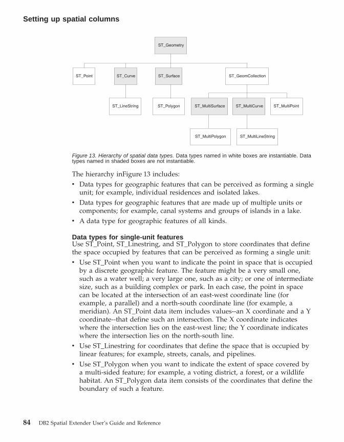
The hierarchy inFigure 13 includes:v Data types for geographic features that can be perceived as forming a single
unit; for example, individual residences and isolated lakes.v Data types for geographic features that are made up of multiple units or
components; for example, canal systems and groups of islands in a lake.v A data type for geographic features of all kinds.
Data types for single-unit featuresUse ST_Point, ST_Linestring, and ST_Polygon to store coordinates that definethe space occupied by features that can be perceived as forming a single unit:v Use ST_Point when you want to indicate the point in space that is occupied
by a discrete geographic feature. The feature might be a very small one,such as a water well; a very large one, such as a city; or one of intermediatesize, such as a building complex or park. In each case, the point in spacecan be located at the intersection of an east-west coordinate line (forexample, a parallel) and a north-south coordinate line (for example, ameridian). An ST_Point data item includes values--an X coordinate and a Ycoordinate--that define such an intersection. The X coordinate indicateswhere the intersection lies on the east-west line; the Y coordinate indicateswhere the intersection lies on the north-south line.
v Use ST_Linestring for coordinates that define the space that is occupied bylinear features; for example, streets, canals, and pipelines.
v Use ST_Polygon when you want to indicate the extent of space covered bya multi-sided feature; for example, a voting district, a forest, or a wildlifehabitat. An ST_Polygon data item consists of the coordinates that define theboundary of such a feature.
ST_MultiLineStringST_MultiPolygon
ST_MultiSurface ST_MultiPointST_LineString ST_Polygon
ST_Point ST_Curve ST_Surface
ST_Geometry
ST_GeomCollection
ST_MultiCurve
Figure 13. Hierarchy of spatial data types. Data types named in white boxes are instantiable. Datatypes named in shaded boxes are not instantiable.
Setting up spatial columns
84 DB2 Spatial Extender User’s Guide and Reference

In some cases, ST_Polygon and ST_Point can be used for the same feature. Forexample, suppose that you need spatial information about an apartmentcomplex. If you want to represent the point in space where each building inthe complex is located, you would use ST_Point to store the X and Ycoordinates that define each such point. On the other hand, if you want torepresent the area occupied by the complex as a whole, you would useST_Polygon to store the coordinates that define the boundary of this area.
Data types for multi-unit featuresUse ST_MultiPoint, ST_MultiLineString, and ST_MultiPolygon to storecoordinates that define spaces occupied by features that are made up ofmultiple units:v Use ST_MultiPoint when you are representing features made up of units
whose locations are each referenced by an X coordinate and a Y coordinate.For example, consider a table whose rows represent island chains. The Xcoordinate and Y coordinate for each island has been identified. If you wantthe table to include these coordinates and the coordinates for each chain asa whole, define an ST_MultiPoint column to hold these coordinates.
v Use ST_MultiLineString when you are representing features made up oflinear units, and you want to store the coordinates for the locations of theseunits and the location of each feature as a whole. For example, consider atable whose rows represent river systems. If you want the table to includecoordinates for the locations of the systems and their components, define anST_MultiLineString column to hold these coordinates.
v Use ST_MultiPolygon when you are representing features made up ofmulti-sided units, and you want to store the coordinates for the locations ofthese units and the location of each feature as a whole. For example,consider a table whose rows represent rural counties and the farms in eachcounty. If you want the table to include coordinates for the locations of thecounties and farms, define an ST_MultiPolygon column to hold thesecoordinates.
Multi-unit is not meant as a collection of individual entities. Rather, multi-unitrefers to an aggregate of the parts that makes up the whole.
A data type for all featuresYou can use ST_Geometry when you are not sure which of the other datatypes to use. Because ST_Geometry is the root of the hierarchy to which theother data types belong, an ST_Geometry column can contain the same kindof data items that columns of the other data types can contain.
Attention:If you plan to use the supplied geocoder, DB2SE_USA_GEOCODER,to produce data for a spatial column, the column must be of typeST_Point or ST_Geometry. Certain visualization tools, however, do not
Setting up spatial columns
Chapter 9. Setting up spatial columns 85

support ST_Geometry columns, but only columns to which a propersubtype of ST_Geometry has been assigned.
Related tasks:
v “Setting up spatial columns for access by visualization tools” on page 86v “Creating spatial columns” on page 86
Creating spatial columns
There are several ways to provide your database with spatial columns:v Use DB2’s CREATE TABLE statement to create a table and to include a
spatial column within that table.v Use DB2’s ALTER TABLE statement to add a spatial column to an existing
table.v If you are importing spatial data from a shape file, use DB2 Spatial
Extender to create a table and to provide this table with a column to holdthe data.
v If you are importing spatial data from an SDE transfer file, use DB2 SpatialExtender to create a table, to provide this table with a column to hold thedata, and to make the column accessible to visualization tools.
For information about how to perform these operations, consult the sourcesthat are listed under “Related tasks” at the end of this discussion.
Related tasks:
v “Writing applications for DB2 Spatial Extender” on page 131v “Setting up spatial columns for access by visualization tools” on page 86
Related reference:
v “Invoking commands for setting up DB2 Spatial Extender and developingprojects” on page 123
Setting up spatial columns for access by visualization tools
If you want certain visualization tools—for example, ArcExplorer—to generategraphical displays of the data in a spatial column, you need to ensure theintegrity of the column’s data. You do this by imposing a constraint thatrequires all rows of the column to use the same spatial reference system. Toimpose this constraint, register the column, specifying both its name and thespatial reference system that applies to it.
Prerequisites:
Setting up spatial columns
86 DB2 Spatial Extender User’s Guide and Reference

Before you register a spatial column, your user ID must hold one of thefollowing forms of authorization:v SYSADM or DBADM authority on the database in which the table that
contains the column residesv The CONTROL or ALTER privilege on this table.
If you are using the db2se command line processor or an application programto import data from an SDE transfer file, you can have DB2 Spatial Extenderautomatically create and register a column to hold the data. In that case, youruser ID must hold SYSADM or DBADM authority on the database.
Procedure:
You can register a spatial column in any of the following ways:v Use the Spatial Columns and Select Spatial Reference System windows of
the DB2 Control Center to register the column.v Issue the db2se register_spatial_column command.v Run an application that invokes the db2gse.ST_register_spatial_column
stored procedure.v If you want to import spatial data from an SDE transfer file, you can use
the Import Spatial Data window of the Control Center, the import_sdecommand, or the db2gse.ST_import_sde stored procedure to create a tablewith a spatial column, to register this column, and to import the data intothe column.
Related tasks:
v “Writing applications for DB2 Spatial Extender” on page 131v “Creating spatial columns” on page 86
Related reference:
v “Invoking commands for setting up DB2 Spatial Extender and developingprojects” on page 123
v “ST_register_spatial_column” on page 212
Setting up spatial columns
Chapter 9. Setting up spatial columns 87

Setting up spatial columns
88 DB2 Spatial Extender User’s Guide and Reference

Chapter 10. Populating spatial columns
After you create spatial columns, and register the ones to be accessed by thesevisualization tools, you are ready to populate the columns with spatial data.There are three ways to supply the data: import it; use a geocoder to derive itfrom business data; or use spatial functions to create it or to derive it frombusiness data or other spatial data. This chapter:v Discusses the concept and task of importing spatial data to your database,
and the concept and task of exporting spatial data to files that applicationscan use.
v Discusses geocoding and introduces the tasks of setting up geocodingoperations, setting up geocoders to run automatically, and runninggeocoders in batch mode.
How to import and export spatial data
This section discusses the concept of importing and exporting data, andintroduces the following tasks:v Importing spatial data to a new table, or to an existing table or viewv Exporting spatial data to files that applications can use
About importing and exporting spatial data
You can use DB2® Spatial Extender to exchange spatial data between yourdatabase and external data sources. More precisely, you can import spatialdata from external sources by transferring it to your database in files, calleddata exchange files. You also can export spatial data from your database to dataexchange files from which external sources can acquire it. This sectionsuggests some of the reasons for importing and exporting spatial data, anddescribes the nature of the data exchange files that DB2 Spatial Extendersupports.
Reasons for importing and exporting spatial data:
By importing spatial data, you can obtain a great deal of spatial informationthat is already available in the industry. By exporting it, you can make itavailable in a standard file format to existing applications. Consider thesescenarios:v Your database contains spatial data that represents your sales offices,
customers, and other business concerns. You want to supplement this datawith spatial data that represents your organization’s culturalenvironment—cities, streets, points of interest, and so on. The data that you
© Copyright IBM Corp. 1998 - 2002 89

want is available from a map vendor. You can use DB2 Spatial Extender toimport it from a data exchange file that the vendor supplies.
v You want to migrate spatial data from an Oracle system to your DB2environment. You proceed by using an Oracle utility to write the data to adata exchange file. You then use DB2 Spatial Extender to import the datafrom this file to the database that you have enabled for spatial operations.
v You are not connected to DB2, and want to use a geobrowser to showvisual presentations of spatial information to customers. The browser needsonly files to work from; it does not need to be connected to a database. Youcould use DB2 Spatial Extender to export the data to a data exchange file,and then use a browser to render the data in visual form.
Shapefiles and SDE transfer files:
DB2 Spatial Extender supports two types of data exchange files: shapefilesand SDE transfer files. The term shapefile actually refers to a collection of fileswith the same file name but different file extensions. The collection caninclude up to four files. They are:v A file that contains spatial data in shape format, a de facto industry-standard
format developed by ESRI. Such data is often called shape data. Theextension of a file containing shape data is .shp.
v A file that contains business data that pertains to locations defined by shapedata. This file’s extension is .dbf.
v A file that contains an index to shape data. This file’s extension is .shx.v A file that contains a specification of the coordinate system on which the
data in a .shp file is based. This file’s extension is .prj.
Shapefiles are often used for importing data that originates in file systems,and for exporting data to files within file systems.
When you use DB2 Spatial Extender to import shape data, you receive at leastone .shp file. In most cases, you receive one or more of the other three kindsof shapefiles as well.
SDE transfer files are often used for importing data that originates in ESRIdatabases. Each file includes spatial data, a spatial reference system for thisdata, and business data. The spatial data, whose format is proprietary to ESRI,is intended for a table column that has been registered to the DB2 SpatialExtender catalog. The business data is targeted for other columns in the tableto which the registered column belongs.
Populating spatial columns
90 DB2 Spatial Extender User’s Guide and Reference

Importing spatial dataThis section provides an overview of the tasks of importing shape data andSDE transfer data to your database. The section includes cross-references tospecifics that you need to know (for example, processes and parameters) inorder to perform these tasks.
Importing shape data to a new or existing table
You can import shape data to an existing table or view, or you can create atable and import shape data to it in a single operation. More specifically, youcan:v Import the shape data to a spatial column in an existing table, an existing
updatable view, or an existing view on which an INSTEAD OF trigger forINSERTs is defined
v Automatically create a table with a spatial column and import the shapedata to this column
Prerequisites:
Before you import shape data to an existing table or view, your user ID musthold one of the following forms of authorization:v SYSADM or DBADM authority on the database that contains the table or
viewv CONTROL privilege on the table or viewv The INSERT privilege on the table or viewv The SELECT privilege on the table or view (required only if the table
includes an idColumn that is not an IDENTITY column)v Privileges to access the directories to which input files and error files
belongv Read privileges on the input files and write privileges on the error files
Before you begin to create a table automatically and import shape data to it,your user ID must hold the following forms of authorization:v SYSADM, DBADM, or CREATETAB authority on the database that contains
the tablev One of the following permissions:
– CREATEIN privilege on the schema to which the table belongs (requiredwhen the schema already exists)
– IMPLICIT_SCHEMA authority on the database that contains the table(required when the schema specified for the table does not actually exist)
v Privileges to access the directories to which input files and error filesbelong
Populating spatial columns
Chapter 10. Populating spatial columns 91
v Read privileges on the input files and write privileges on the error files
Procedure:
You can import shape data in any of the following ways:v Use the Import Shape Data window of the DB2 Control Center.v Issue the db2se import_shape command.v Run an application that calls the db2gse.ST_import_shape stored procedure.
Recommendation:
You can enhance the performance of import processing by exploiting featuresavailable in DB2. For example, when you import data to an existing table orto a table that you create, define the table as NOT LOGGED INITIALLY byspecifying the appropriate table creation parameters.
Related concepts:
v “About importing and exporting spatial data” on page 89
Related tasks:
v “Importing SDE transfer data to a new or existing table” on page 92v “Writing applications for DB2 Spatial Extender” on page 131
Related reference:
v “Invoking commands for setting up DB2 Spatial Extender and developingprojects” on page 123
v “ST_import_shape” on page 198
Importing SDE transfer data to a new or existing table
You can import SDE transfer data to an existing table, or you can create atable and import SDE transfer data to it in a single operation. Morespecifically, you can:v Import SDE transfer data to an existing table that includes a spatial column
that is already registered to the DB2 Spatial Extender catalog. The transferdata can include spatial data for the column and business data for othercolumns in the table.
v Automatically create a table that has a spatial column, register this columnto the catalog, and import SDE transfer data to this column as well as tothe table’s other columns.
Prerequisites:
Populating spatial columns
92 DB2 Spatial Extender User’s Guide and Reference
Before you import data to a column in an existing table or view, your user IDmust hold one of the following forms of authorization:v SYSADM or DBADM authority on the database that contains the table or
viewv CONTROL privilege on the table or viewv Both the INSERT and SELECT privileges on the table or view
Before you initiate the operation to create a table automatically and importshape data to it, your user ID must hold the following forms of authorization:v Either SYSADM, DBADM, or CREATETAB authority on the database that
contains the tablev One of the following permissions:
– CREATEIN privilege on the schema to which the table belongs (requiredwhen the schema already exists)
– IMPLICIT_SCHEMA authority on the database that contains the table(required when the schema specified for the table does not actually exist)
Procedure:
You can import SDE transfer data in any of the following ways:v Use the Import window of the DB2 Control Center.v Issue the db2se import_sde command.v Run an application that calls the db2gse.GSE_import_sde stored procedure.
For information about how to perform these actions, consult the sources thatare listed under “Related tasks” at the end of this discussion.
Related concepts:
v “About importing and exporting spatial data” on page 89
Related tasks:
v “Importing shape data to a new or existing table” on page 91v “Writing applications for DB2 Spatial Extender” on page 131
Related reference:
v “Invoking commands for setting up DB2 Spatial Extender and developingprojects” on page 123
v “GSE_import_sde” on page 162
Populating spatial columns
Chapter 10. Populating spatial columns 93

Exporting spatial dataThis section provides an overview of the tasks of exporting spatial data toshape and SDE transfer files. The section includes cross-references to specificsthat you need to know (for example, processes and parameters) in order toperform these tasks.
Exporting data to a shapefile
You can export spatial data returned in query results to a shapefile. The datamight come from sources such as a base table, a join or union of multipletables, result sets returned when you query views, or output of a spatialfunction.
If a file to which you want to export data exists, DB2 Spatial Extender canappend the data to this file. If such a file does not exist, you can use DB2Spatial Extender to create one.
Prerequisites:
Before you can export data to a shapefile, your user ID must hold thefollowing privileges:v The privilege to execute a subselect that returns the results that you want to
exportv The privilege to write to the directory where the file to which you will be
exporting data residesv The privilege to create a file to contain the exported data (required if such a
file does not already exist)
To find out what these privileges are and how to obtain them, consult yourdatabase administrator.
Procedure:
You can export data to a shapefile in any of the following ways:v Initiate the export from the Export Shape File window of the DB2 Control
Center.v Issue the db2se export_shape command from the db2se command line
processor.v Run an application that calls the db2gse.ST_export_shape stored procedure.
For information about how to perform these actions, consult the sources thatare listed under “Related tasks” at the end of this discussion.
Populating spatial columns
94 DB2 Spatial Extender User’s Guide and Reference
Exporting data to an SDE transfer file
You can export a table that contains spatial data to an SDE transfer file. Thetable cannot contain more than one spatial column. Moreover, this columnmust be registered to the DB2 Spatial Extender catalog. If the table containsbusiness data, this data will be exported along with the spatial data. You canexport either all rows in the table or a subset of rows. To export a subset,specify a WHERE clause that identifies the subset.
Prerequisites:
Before you can export data to an SDE transfer file, your user ID must hold thefollowing permissions:v Either SYSADM OR DBADM authority.v The SELECT privilege on the table that is to be exported.v The privilege to write to the directory where the file to which you will be
exporting data resides
Restrictions:
v You can export only one spatial column in each export operation.v The columns that you export must have data types that the SDE format
supports.v The table must contain exactly one spatial column.v This column must be registered to the DB2 Spatial Extender catalog.v You cannot append to existing SDE files.
Procedure:
You can export spatial and business data to an SDE transfer file in any of thefollowing ways:v Use the Export SDE Files window of the DB2 Control Center.v Issue the db2se export_sde command.v Run an application that calls the db2gse.GSE_export_sde stored procedure.
Related concepts:
v “About importing and exporting spatial data” on page 89
Related tasks:
v “Writing applications for DB2 Spatial Extender” on page 131
Related reference:
v “Invoking commands for setting up DB2 Spatial Extender and developingprojects” on page 123
Populating spatial columns
Chapter 10. Populating spatial columns 95
v “GSE_export_sde” on page 160
How to use a geocoder
This section discusses the concept of geocoding and introduces the followingtasks:v Defining the work that you want a geocoder to do; for example, specifying
how may records the geocoder should process before a commit is issuedv Setting up a geocoder to geocode data as soon as the data is added to, or
updated in, a table.v Running a geocoder in batch mode
Geocoders and geocoding
The terms geocoder and geocoding are used in several contexts. This discussionsorts out these contexts, so that the terms’ meanings can be clear each timeyou come across the terms. The discussion defines geocoder and geocoding,describes the modes in which a geocoder operates, describes a larger activityto which geocoding belongs, and summarizes users’ tasks that pertain togeocoding.
In DB2® Spatial Extender, a geocoder is a scalar function that translatesexisting data (the function’s input) into data that you can understand inspatial terms (the function’s output). Typically, the existing data is relationaldata that describes or names a location. For example, the geocoder that isshipped with DB2 Spatial Extender, DB2SE_USA_GEOCODER, translatesUnited States addresses into ST_Point data. DB2 Spatial Extender can supportvendor-supplied and user-supplied geocoders as well; and their input andoutput need not be like that of DB2SE_USA_GEOCODER. To illustrate: Onevendor-supplied geocoder might translate addresses into coordinates that DB2does not store, but rather writes to a file. Another might be able to translatethe number of an office in a commercial building into coordinates that defineoffice’s location in the building, or to translate the identifier of a shelf in awarehouse into coordinates that define the shelf’s location in the warehouse.
In other cases, the existing data that a geocoder translates might be spatialdata. For example, a user-supplied geocoder might translate X and Ycoordinates into data that conforms to one of DB2 Spatial Extender’s datatypes.
In DB2 Spatial Extender, geocoding is simply the operation in which a geocodertranslates its input into output—translating addresses into coordinates, forexample.
Modes:
Populating spatial columns
96 DB2 Spatial Extender User’s Guide and Reference

A geocoder operates in two modes:v In batch mode, a geocoder attempts, in a single operation, to translate all its
input from a single table. For example, in batch mode,DB2SE_USA_GEOCODER attempts to translate all the addresses in a singletable (or, alternatively, all addresses in a specified subset of rows in thetable).
v In automatic mode, a geocoder translates data as soon as it is inserted orupdated in a table. The geocoder is activated by INSERT and UPDATEtriggers that are defined on the table.
Geocoding processes:
Geocoding is one of several operations by which the contents of a spatialcolumn in a DB2 table are derived from other data. This discussion refers tothese operations collectively as a geocoding process. Geocoding processes canvary from geocoder to geocoder. For example, DB2SE_USA_GEOCODERsearches files of known addresses to determine whether each address itreceives as input matches a known address to a given degree. Because theknown addresses are like reference material that people look up when they doresearch, these addresses are collectively called reference data. Other geocodersmight not need reference data; they might verify their input in other ways.The geocoding process that DB2SE_USA_GEOCODER participates in is asfollows:1. DB2SE_USA_GEOCODER performs operations that it has been designed
to carry out:a. DB2SE_USA_GEOCODER parses each address that it receives as input.b. DB2SE_USA_GEOCODER searches the reference data for street names
that, to a certain degree, resemble the street name in the parsedaddress. It confines its search to streets within the area designated bythe address’s zip code.
c. If the search is successful, DB2SE_USA_GEOCODER determineswhether any address on the streets it has found match the parsedaddress to a certain degree.
d. If DB2SE_USA_GEOCODER finds a match, it geocodes the parsedaddress. Otherwise, it returns a null.
2. If DB2SE_USA_GEOCODER geocodes the parsed address, DB2 puts theresulting coordinates in a designated spatial column.
3. If DB2SE_USA_GEOCODER is geocoding in batch mode, DB2 SpatialExtender issues a commit either (a) every time DB2SE_USA_GEOCODERfinishes processing a certain number of input records or (b) afterDB2SE_USA_GEOCODER finishes processing all of its input.
The user’s tasks:
Populating spatial columns
Chapter 10. Populating spatial columns 97

In DB2 Spatial Extender, the tasks that pertain to geocoding are:v Prescribing how certain parts of the geocoding process should be executed
for a given spatial column; for example, setting the minimum degree towhich street names in input records and street names in reference datashould match; setting the minimum degree to which addresses in inputrecords and addresses in reference data should match; and determininghow many records should be processed before each commit. This task canbe referred to as setting up geocoding or setting up geocoding operations.
v Specifying that data should be automatically geocoded each time that it isadded to, or updated in, a table. When automatic geocoding occurs, theinstructions that the user specified when he or she set up geocodingoperations will take effect (except for the instructions involving commits;they apply only to batch geocoding). This task is referred to as setting up ageocoder to run automatically.
v Running a geocoder in batch mode. If the user has set up geocodingoperations already, his or her instructions will remain in effect during eachbatch session, unless the user overrides them. If the user has not set upgeocoding operations before a given session, the user can specify that theyshould take effect set them up for that particular session. This task can bereferred to as running a geocoder in batch mode and running geocoding in batchmode.
Setting up geocoding operations
DB2 Spatial Extender lets you set, in advance, the work that needs to be donewhen a geocoder is invoked. For example, you can specify:v What column the geocoder is to provide data for.v Whether the input that the geocoder reads from a table or view should be
limited to a subset of rows in the table or view.v The range or number of records that the geocoder should geocode in batch
sessions within a unit of workv Requirements for geocoder-specific operations. For example,
DB2SE_USA_GEOCODER can geocode only those records that match theircounterparts in the reference data to a specified degree or higher. Thisdegree is called the minimum match score.
You must specify the parameters described in the foregoing before you set upthe geocoder to run in automatic mode. From then on, each time the geocoderis invoked (not only automatically, but also for batch runs), geocodingoperations will be performed in accordance with your specifications. Forexample, if you specify that 45 records should be geocoded in batch modewithin each unit of work, a commit will be issued after every forty-fifthrecord is geocoded. (Exception: you can override your specifications forindividual sessions of batch geocoding.)
Populating spatial columns
98 DB2 Spatial Extender User’s Guide and Reference

You do not have to establish defaults for geocoding operations before you runthe geocoder in batch mode. Rather, at the time that you initiate a batchsession, you can specify how the operations are to be performed for the lengthof the run. If you do establish defaults for batch sessions, you can overridethem, as needed, for individual sessions.
Prerequisites:
Before you can set geocoding operations for a particular geocoder, your userID must hold one of the following forms of authorization:v SYSADM or DBADM authority on the database that contains the tables that
the geocoder will operate onv The SELECT privilege and the CONTROL or UPDATE privilege on each
table that the geocoder operates on
Procedure:
You can set up geocoding operations in any of the following ways:v Invoke it from the Set Up Geocoding window of the DB2 Control Center.v Issue the db2se setup_gc command.v Run an application that calls the db2gse.ST_setup_geocoding stored
procedure.
For information about how to perform these actions, consult the sources thatare listed under “Related tasks” at the end of this discussion.
Recommendations:
v When DB2SE_USA_GEOCODER reads a record of address data, it tries tomatch that record with a counterpart in the reference data. In broad outline,the way it proceeds is as follows: First, it searches the reference data forstreets whose zip code is the same as the zip code in the record. If it finds astreet name that is similar to the one in the record to a certain minimumdegree, or to a degree higher than this minimum, it goes on to look for anentire address. If it finds an entire address that is similar to the one in therecord to a certain minimum degree, or to a degree higher than thisminimum, it geocodes the record. If it does not find such an address, itreturns a null.The minimum degree to which the street names must match is referred toas spelling sensitivity. The minimum degree to which the entire addressesmust match is called the minimum match score. For example, if the spellingsensitivity is 80, then the match between the street names must be at least80 percent accurate before the geocoder will search for the entire address. If
Populating spatial columns
Chapter 10. Populating spatial columns 99
the minimum match score is 60, then the match between the addressesmust be at least 60 percent accurate before the geocoder will geocode therecord.You can specify what the spelling sensitivity and minimum match scoreshould be. Be aware that you might need to adjust them. For example,suppose that the spelling sensitivity and minimum match score are both 95.If the addresses that you want geocoded have not been carefully validated,matches of 95 percent accuracy are highly unlikely. As a result, thegeocoder is likely to return a null when it processes these records. In such acase, it is advisable to lower the spelling sensitivity and minimum matchscore, and run the geocoder again. Recommended scores for spellingsensitivity and the minimum match score are 70 and 60, respectively. .
v As noted at the start of this discussion, you can determine whether theinput that the geocoder reads from a table or view should be limited to asubset of rows in the table or view. For example, consider the followingscenario:– You invoke the geocoder to geocode addresses in a table in batch mode.
Unfortunately, the minimum match score is too high, causing thegeocoder to return a null when it processes most of the addresses. Youreduce the minimum match score when you run the geocoder again. Tolimit its input to those addresses that were not geocoded, you specifythat it should select only those rows that contain the null that it hadreturned earlier.
Other scenarios:– The geocoder selects only rows that were added after a certain date.– The geocoder selects only rows that contain addresses in a particular
area; for example, a block of counties or a state.v As noted at the start of this discussion, you can determine the number of
records that the geocoder should process in batch sessions within a unit ofwork. You can have the geocoder process the same number of records ineach unit of work, or you can have it process all the records of a tablewithin a single unit of work. If you choose the latter alternative, be awarethat:– You have less control over the size of the unit of work than the former
alternative affords. Consequently, you cannot control how many locks areheld or how many log entries are made as the geocoder operates.
– If the geocoder encounters an error that necessitates a rollback, you needto run the geocoder to run against all the records again. The resultingcost in resources can be expensive if the table is extremely large and theerror and rollback occur after most records have been processed.
Populating spatial columns
100 DB2 Spatial Extender User’s Guide and Reference
Setting up a geocoder to run automatically
You can set up a geocoder to automatically translate data as soon as the datais added to, or updated in, a table.
Prerequisites:
Before you can set up a geocoder to run automatically:v You must set up geocoding operations for each spatial column that is to be
populated by output from the geocoder.v Your user ID must hold the following forms of authorization:
– SYSADM or DBADM authority on the database that contains the tableon which triggers to invoke the geocoder will be defined
– One or more privileges on this table:- The CONTROL privilege.- If you do not have the CONTROL privilege, you need the ALTER,
SELECT, and UPDATE privileges.– The privileges required to create triggers on this table.
Procedure:
There are three ways to set up automatic geocoding:v Do so from either the Set Up Geocoding window or the Geocoding window
of the DB2 Control Center.v Issue the db2se enable_autogc command.v Run an application that calls the db2gse.ST_enable_autogeocoding stored
procedure.
For information about how to perform these actions, consult the sources thatare listed under “Related tasks” at the end of this discussion.
Recommendations:
v You can set up a geocoder to run automatically before you invoke it inbatch mode. Therefore, it is possible for automatic geocoding to precedebatch geocoding. If that happens, the batch geocoding is likely to involveprocessing the same data that was processed automatically. Thisredundancy will not result in duplicate data, because when spatial data isproduced twice, the second yield of data overrides the first. However, it candegrade performance.
v Before you decide whether to geocode the address data within a table inbatch mode or automatic mode, consider that:– Performance is better in batch geocoding than in automatic geocoding. A
batch session opens with one initialization and ends with one cleanup. In
Populating spatial columns
Chapter 10. Populating spatial columns 101
automatic geocoding, each data item is geocoded in a single operationthat begins with initialization and concludes with cleanup.
– On the whole, a spatial column populated by means of automaticgeocoding is likely to be more up to date than a spatial columnpopulated by means of batch geocoding. After a batch session, addressdata can accumulate and remain ungeocoded until the next session. Butif automatic geocoding is already enabled, address data is geocoded assoon as it is stored in the database.
Running a geocoder in batch mode
You can invoke a geocoder to run in batch mode; that is, to attempt, in asingle operation, to translate multiple records into spatial data that is to gointo a specific column.
At any time before you run a geocoder to populate a particular spatialcolumn, you can set up geocoding operations for that column. Setting up theoperations involves specifying how certain requirements are to be met whenthe geocoder is run. For example, suppose that you require DB2 SpatialExtender to issue a commit after every 100 input records are processed by thegeocoder. When you set up the operations, you would specify 100 as therequired number.
When you are ready to run the geocoder, you can override any of the valuesthat you specified when you set up operations. Your overrides will remain ineffect only for the length of the run.
If you do not set up operations, you must, each time you are ready to run thegeocoder, specify how the requirements are to be met during the run.
Prerequisites:
Before you can run a geocoder in batch mode, your user ID must hold one ofthe following forms of authorization:v SYSADM or DBADM authority on the database that contains the table
whose data is to be geocodedv The CONTROL or UPDATE privilege on this tablev
You also need the SELECT privilege on this table, so that you can specify thenumber of records to be processed before each commit. If you specify WHEREclauses to limit the rows on which the geocoder is to operate, you might alsorequire the SELECT privilege on any tables and views that you reference inthese clauses. Ask your database administrator.
Populating spatial columns
102 DB2 Spatial Extender User’s Guide and Reference

Restrictions:
Procedure:
You can invoke a geocoder to run in batch mode in any of the followingways:v Invoke it from the Run Geocoding window of the DB2 Control Center.v Issue the db2se run_gc command.v Run an application that calls the db2gse.ST_run_geocoding stored
procedure.
Populating spatial columns
Chapter 10. Populating spatial columns 103

Populating spatial columns
104 DB2 Spatial Extender User’s Guide and Reference
Chapter 11. Using indexes and views to access spatialdata
Before you query spatial columns, you can create indexes and views that willfacilitate access to them. This chapter:v Describes the nature of the indexes that Spatial Extender uses to expedite
access to spatial datav Explains how to create such indexesv Explains how to use views to access spatial data
Spatial indexes
DB2® Spatial Extender’s indexing technology utilizes grid indexing, which isdesigned to index multi-dimensional spatial data, to index spatial columns.DB2 Spatial Extender provides a grid index that is optimized for twodimensional data, however higher dimensional geometries can be indexed aswell. The index is created on the X and Y dimensions.
A spatial grid index is generated using the minimum bounding rectangle(MBR) of a geometry. For most geometries, the MBR is a rectangle thatsurrounds the geometries. Wherever possible, its four sides coincide with thegeometry’s boundary. The MBR for a horizontal or vertical linestring is adegenerated rectangle that is collapsed into the linestring itself. The MBR of apoint is a degenerated rectangle that is collapsed into the point (the originalpoint itself). An MBR is itself a geometry; it is represented by the minimumand maximum X and Y coordinates of the geometry that it surrounds orcollapses to.
The spatial index is constructed on a spatial column by making one or moreentries for the intersections of each geometry’s MBR with the grid cells. Anintersection is recorded as the internal identifier of the row that contains thegeometry and the minimum X and Y coordinates of the grid cell intersected.DB2 Spatial Extender supports up to three spatial index levels (grid levels).Using several grid levels is beneficial because it allows you to optimize theindex for different sizes of spatial data. A small value should be used for thefinest grid size to optimize the overall index for small geometries in thecolumn. This avoids the overhead of evaluating geometries that are not withinthe search area. However, the finest grid size also produces the highestnumber of index entries. Consequently, the number of index entries processedat query time increases, as does the amount of storage needed for the index.These factors reduce overall performance.
© Copyright IBM Corp. 1998 - 2002 105

Using larger grid sizes, the index can be optimized further for largergeometries. The larger grid sizes produce fewer index entries for largegeometries than the finest grid size would. Consequently, storagerequirements for the index are reduced, increasing overall performance.
Each grid level should be at least three times larger than the previous level. Ifa feature intersects four or more grid cells, the feature is promoted to the nextlarger level. In general, the larger features will be indexed at the larger levels.
For example, if multiple grid levels exist, the indexing algorithm attempts touse the lowest grid level possible to provide the finest resolution for theindexed data. When a geometry intersects more than four grid cells at a givenlevel, it is promoted to the next higher level, (provided that there is anotherlevel). Therefore, a spatial index that has the three grid levels of 10.0e0,100.0e0, and 1000.0e0 will first intersect each geometry with the level 10.0e0grid. If a geometry intersects with more than four grid cells of size 10.0e0, it ispromoted and intersected with the level 100.0e0 grid. If more than fourintersections result at the 100.0e0 level, the geometry is promoted to the1000.0e0 level. At the 1000.0e0 level, the intersections must be entered into thespatial index because this is the highest possible level.
For more information about spatial indexes, see the Spatial indexes DB2 topic.
How to create spatial grid indexes
Good query performance is related to having efficient indexes defined on thecolumns of the base tables in a database. The performance of the query isdirectly related to how quickly values in the column can be found during thequery.
Spatial queries are typically queries that involve two or more dimensions. Forexample, in a spatial query you might want to know if a point is includedwithin an area (polygon). Due to the multidimensional nature of spatialqueries, the DB2® native B-tree indexing is inefficient for these queries. Forthis reason, DB2 Spatial Extender provides an index based on a grid called aspatial grid index. If you create a spatial grid index on the spatial column, theindex entries can be scanned much more quickly than can all the values in thecolumn itself. Then the performance of the query is improved.
When you create a spatial grid index, you give it: a name, the name of thespatial column on which it is to be defined, and the grid sizes. For detailedinformation on the relationship between spatial grid indexes and grid sizes,please see Spatial indexesSpatial indexes. The grid sizes define the resolutionwith which the space is partitioned. The combination of the three grid sizes
Using indexes and views
106 DB2 Spatial Extender User’s Guide and Reference

works to minimize the size of the grid cells while also minimizing the size ofthe spatial grid index, by minimizing the total number of index entries.
Knowledge of the relative geometry size distribution of the data in the spatialcolumn is important information to use when determining the optimum gridsize and number of grid levels to use. DB2 Spatial Extender provides a utility,called the Index Advisor that will analyze the spatial column data andsuggest appropriate grid sizes.
The following sections in this topic describe:v The steps for creating a spatial grid indexv General guidelines for how to get the most out of your spatial grid indexes
The Index Advisor is described in Using the index advisor.
Creating spatial grid indexesThere are several ways to create a spatial grid index:v Using the Control Center.v Using the SQL CREATE INDEX statement with the db2gse.spatial_index
index extension in the EXTEND USING clause.v Using a GIS tool that works with DB2 Spatial Extender. If you use such a
tool to create the index, the tool will issue the same SQL CREATE INDEXstatement as described before.
This section presents the steps for the first two methods. For information onusing a GIS tool to create a spatial grid index, see the documentation thatcomes with that tool.
Prerequisites:
Before you create a spatial grid index, your user ID must hold theauthorizations that are needed for the DB2 SQL CREATE INDEX statement.The user ID must include at least one of the following:v SYSADM or DBADM authority on the database where the table that has the
column residesv One of the following items:
– CONTROL privilege on the table– INDEX privilege on the table
And one of the following items:– IMPLICIT_SCHEMA authority on the database, if the implicit or explicit
schema of the index does not exist– CREATEIN privilege on the schema, if the schema name of the index
refers to an existing schema
Using indexes and views
Chapter 11. Using indexes and views to access spatial data 107

For a complete description of the DB2 SQL CREATE INDEX statement, seeCREATE INDEX statement.
Before you create a spatial grid index on a column, it is recommended thatyou use the Index Advisor to determine the parameters for the index. TheIndex Advisor can analyze the spatial column data and suggest appropriategrid sizes for your spatial grid index. For more information on using theIndex Advisor, see the Related tasks section at the end of this topic.
Before you create a spatial grid index, you must know the values you want tospecify for the fully qualified spatial grid index name and the three grid sizesthat the index will use.
Restrictions:
The same restrictions for creating indexes using the CREATE INDEXstatement are in effect when you create a spatial grid index: the column onwhich you create an index must be a base table column, not a view column ora nickname column. DB2 will resolve aliases in the process.
Procedure:
To do this task using the Control Center:1. In the Control Center, right-click the table that has the spatial
column that you want a spatial grid index on and select SpatialExtender—�Spatial Indexes from the pop-up menu. The SpatialIndexes window opens.
2. Follow the instructions in the online help for the Spatial Indexeswindow. You can display those instructions by clicking on theHelp button in the Spatial Indexes window.
To do this task using the SQL CREATE INDEX statement:Issue the CREATE INDEX command using the EXTEND USINGclause and the db2gse.spatial_index grid index extension. Thecommand is:
�� CREATE INDEX index_nameindex_schema.
ON �
� table_nametable_schema.
( column_name ) EXTEND USING �
� db2gse.spatial_index ( finest_grid_size , middle_grid_size �
� , coarsest_grid_size ) ��
Where:
Using indexes and views
108 DB2 Spatial Extender User’s Guide and Reference

index_schema.Name of the schema to which the index that you are creatingis to belong. If you do not specify a name, DB2 uses theschema name that is stored in the CURRENT SCHEMAspecial register.
index_nameUnqualified name of the grid index that you are creating.
table_schema.Name of the schema to which the table that containscolumn_name belongs. If you do not specify a name, DB2 usesthe schema name that is stored in the CURRENT SCHEMAspecial register.
table_nameUnqualified name of the table that contains column_name.
column_nameName of the spatial column on which the spatial grid index iscreated.
finest_grid_size, middle_grid_size, coarsest_grid_sizeGrid sizes for the spatial grid index. These parameters mustadhere to the following conditions:v finest_grid_size must be larger than 0.v middle_grid_size must either be larger than finest_grid_size or
equal 0 (zero).v coarsest_grid_size must either be larger than middle_grid_size
or equal 0 (zero).
For example, for table BRANCHES that has a spatial columnLOCATION, the spatial grid index LOCIDX is created on that column:CREATE INDEX locidx
ON branches (location)EXTEND USING db2gse.spatial_index (1.0, 10.0, 100.0)
Whether you create the spatial grid index using the Control Center or theCREATE INDEX statement, the validity of the grid sizes are checked when thefirst geometry is indexed. Therefore, if the grid sizes that you specify do notmeet the conditions on their values, an error condition is raised at the timesas described in these situations:v If there are no non-null geometries in the spatial column, the spatial grid
index creation process will succeed. The validity of the grid sizes is verifiedwhen a non-null geometry is inserted or updated in that spatial column. Ifthe specified grid sizes are not valid, an error condition is raised when thenon-null geometry is inserted or updated.
Using indexes and views
Chapter 11. Using indexes and views to access spatial data 109
v If there are non-null geometries in the spatial column, the validity of thegrid sizes is verified during the spatial grid index creation process. If thespecified grid sizes are not valid, the process will fail during the indexingof the existing geometries. The error condition is raised immediately, andthe spatial grid index is not created.
General guidelines for getting the most out of spatial grid indexesIt is recommended that you use the Index Advisor for determiningappropriate grid sizes for your spatial grid indexes. Because you can use theIndex Advisor to:v Analyze an existing spatial grid indexv Analyze the geometries in a spatial column for which you want to create a
spatial grid index
It is the best way for you to tune your spatial grid indexes and make yourspatial queries most efficient.
Besides following the recommendations from the Index Advisor, you can usethe tips presented in these sections for fine tuning your spatial grid indexes.The general rule is to decrease the grid sizes as much as possible to get thefinest resolution while minimizing the number of index entries. A small gridsize tends to result in a large number of entries in the index. Try to strike abalance between the two.
Tips on selecting the number of grid levelsHere are some tips on selecting the number of grid levels for a spatial gridindex:v If the values in the spatial column are about the same relative size, use a
single grid level. You can have up to three grid levels. However, for eachgrid level in a spatial grid index, a separate index search will be performedduring a spatial query. Therefore, if you have more grid levels, your querywill be less efficient.Typically, a spatial column will not contain geometries of the same relativesize. However, usually geometries in a spatial column can be groupedaccording to size. You would correspond your grid levels with thesegeometry groupings.For example, suppose you have a table of county land parcels with a spatialcolumn that contains groupings of small urban parcels surrounded bylarger rural parcels. Because the sizes of the parcels can be grouped intotwo groups (small urban ones and larger rural ones), you would specifytwo grid levels for the spatial grid index.
v When you use more than one grid level, make the size of each grid level atleast three times larger than the size of the preceding grid level. Forexample, if your first (finest) grid level has a size of 10.0, make the next oneat least 30.0.
Using indexes and views
110 DB2 Spatial Extender User’s Guide and Reference

Tips on selecting grid cell sizesHere are some tips on selecting the grid cell sizes for each grid level of yourspatial grid index:v Make the grid cell size for each grid level at least three times the size of the
cells of the preceding grid level.v If you are planning to do an initial load of data into the column, you
should create the spatial grid index after completing the load process. Thatway, you can choose optimal grid cell sizes that are based on thecharacteristics of the data by using the Index Advisor. In addition, loadingthe data before creating the index will improve the performance of the loadprocess because then the spatial grid index does not have to be maintainedduring the load process.
Related tasks:
v “Using the Index Advisor” on page 111
Related reference:
v “CREATE INDEX statement” in the SQL Reference, Volume 2
Using the Index Advisor
DB2 Spatial Extender provides a utility, called the Index Advisor, that lets you:v Create a simulated grid index and tune this index until it becomes a
satisfactory model for a real grid index.v Determine whether to retain or replace an existing grid index.
This section explains how to use the Index Advisor and documents the syntaxand parameters of the command that invokes it.
Prerequisites:
Before you can access the data that you are indexing:v If you want to use the ANALYZE clause to analyze a subset of the rows
only, you must have a USER TEMPORARY table space available. Set thepage size of this table space to at least 8 KB.
v Your user ID must hold the SELECT privilege on this table.
Procedure for creating and tuning a simulated grid index:
To create and tune a simulated index:1. Prepare to initiate the command that invokes the Index Advisor.2. Ask the Index Advisor to recommend grid cell sizes for the index that you
want to create.
Using indexes and views
Chapter 11. Using indexes and views to access spatial data 111

3. Have the Index Advisor collect statistics based on the recommended gridcell sizes.
4. Determine how well the recommended grid cell sizes facilitate retrieval.5. If the statistics are not satisfactory, improve them by repeating steps 2, 3,
and 4.
Details follow.1. Prepare to initiate the command that invokes the Index Advisor:
a. From an operating system prompt, type gseidx CONNECT TO mydb<,where mydbis the name of the database that contains the table with thecolumn whose data you want to index.
b. If you want to use another user ID to connect, specify this ID and itspassword. Precede the ID with the keyword USER and precede thepassword with the keyword USING. For example:gseidx CONNECT TO mydb USER user ID USING ppassword
2. Ask the Index Advisor to recommend grid cell sizes for the index that youwant to create:a. Type the command that invokes the Index Advisor. You can either:
v Simply request grid cell sizes. To do so specify the ADVISEkeyword.
v Request grid cell sizes that are based on the data that your queriestypically access. To do this, determine the overall extent of the datain the column for which you want to create an index. Next,determine what percentage of this extent is typically accessed byyour queries. Then specify the ADVISE QUERY BOX keywords andset the query-box-size parameter to this percentage.
b. Run the command. The Index Advisor returns recommended grid cellsizes.
3. Have the Index Advisor collect statistics based on the recommended gridcell sizes.a. Type the command again. This time specify keywords to request
statistics based on the grid cell sizes that the Index Advisorrecommended. You can ask for statistics on either all the data indexedor a subset of this data.v To obtain statistics on all indexed data, specify the simulated-index
clause. In this clause, specify the grid cell size or sizes that werereturned in step 2b.
v To obtain statistics on indexed data in a subset of rows, specify:– The simulated-index clause. In this clause, specify the grid cell
size or sizes that were returned in step 2b.
Using indexes and views
112 DB2 Spatial Extender User’s Guide and Reference

– The ANALYZE keyword and its parameters. These commandelements let you determine either the number or percentage ofrows that the Advisor should analyze to obtain statistics.
Tip: If the table includes over 1000 rows, and its data isdistributed more or less uniformly, request an analysis of1000 rows. If the data is not distributed uniformly, request ananalysis of more than 1000 rows.
b. Run the command. The Index Advisor returns statistics on thesimulated index.
4. Determine how well the recommended grid cell sizes facilitate retrieval.You can do this by assessing the statistics returned in step 3b.
Tips:
v The statistic, “Index Entry/Geometry ratio”, ″ should be 1 to 4v The statistic, “Number of Index Entries”, should be close or equal
to the statistic, “Number of Geometries”.5. If the statistics are not satisfactory, improve them by repeating steps 2, 3,
and 4.
Tip: If the Index Advisor analyzed a subset of rows, and if the statisticsare satisfactory, repeat steps 2, 3, and 4 multiple times, increasing thenumber of rows in the analysis each time. Continue to do this untilthe statistics are satisfactory with each repetition.
Procedure for determining whether to retain an existing grid index:
Statistics on an existing grid index can tell you whether it is efficient, orwhether it should be replaced by a more efficient index. To obtain thesestatistics and, if necessary, to replace the index:1. Prepare to initiate the command that invokes the Index Advisor.2. Have the Index Advisor collect statistics based on the grid cell sizes of the
existing index.3. Determine how well these grid cell sizes facilitate retrieval.4. If the statistics are not satisfactory:
a. Create a simulated grid index and tune this index until it becomes asatisfactory model for a real grid index.
b. Drop the existing index and replace it with an index that matches thesimulated one.
Details follow.1. Prepare to initiate the command that invokes the Index Advisor:
Using indexes and views
Chapter 11. Using indexes and views to access spatial data 113

a. From an operating system prompt, type gseidx connect to mydb,where mydb is the name of the database that contains the table with thecolumn for which you want to provide or test an index.
b. If you want to connect to the database under a different user ID toconnect, specify this ID and its password. Precede the ID with thekeyword USER and precede the password with the keyword USING.For example:gseidx CONNECT TO mydb USER user ID USING password
2. Have the Index Advisor collect statistics based on the grid cell sizes of theexisting index. You can ask for statistics on either all indexed data or asubset of this data.v To obtain statistics on all indexed data, type the GET GEOMETRY
STATISTICS | INFORMATION command and specify itsexisting-index clause. Include the DETAIL keyword.
v To obtain statistics on indexed data in a subset of rows, type the GETGEOMETRY STATISTICS | INFORMATION command and specify:– Its existing-index clause. Include the DETAIL keyword.– The ANALYZE keyword and its parameters. These command
elements let you determine either the number or percentage of rowsthat the Index Advisor is to analyze to obtain statistics.
Tip: If the table includes over 1000 rows, and its data is distributedmore or less uniformly, request an analysis of 1000 rows. If thedata is not distributed uniformly, request an analysis of morethan 1000 rows.
Run the command. The Index Advisor returns statistics on the existingindex.
3. Determine how well the grid cell sizes of the existing index facilitateretrieval. You can do this by assessing the statistics returned in step 2.
Tips:
v The statistic, “Index Entry/Geometry ratio”, ″ should be 1 to 4v The statistic, “Number of Index Entries”, should be close or equal
to the statistic, “Number of Geometries”.4. If the statistics are not satisfactory:
a. Create a simulated grid index over the column for which the existingindex is defined. Tune this simulated index until it becomes asatisfactory model for a real grid index.
b. Drop the existing index and replace it with an index that matches thesimulated one.
Using indexes and views
114 DB2 Spatial Extender User’s Guide and Reference
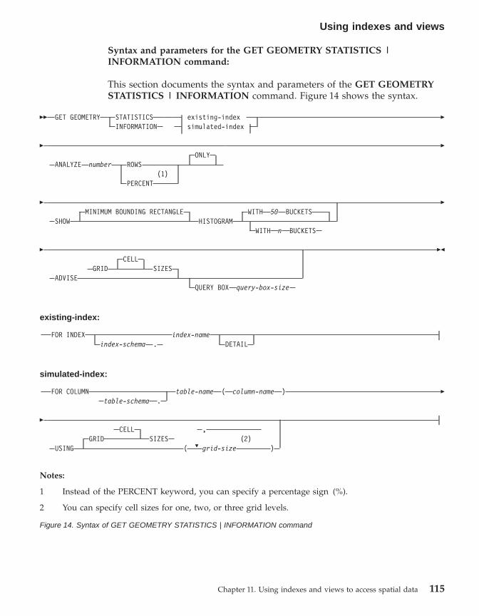
Syntax and parameters for the GET GEOMETRY STATISTICS |INFORMATION command:
This section documents the syntax and parameters of the GET GEOMETRYSTATISTICS | INFORMATION command. Figure 14 shows the syntax.
�� GET GEOMETRY STATISTICSINFORMATION
existing-indexsimulated-index
�
�ONLY
ANALYZE number ROWS(1)
PERCENT
�
�MINIMUM BOUNDING RECTANGLE WITH 50 BUCKETS
SHOW HISTOGRAMWITH n BUCKETS
�
�CELL
GRID SIZESADVISE
QUERY BOX query-box-size
��
existing-index:
FOR INDEX index-nameindex-schema . DETAIL
simulated-index:
FOR COLUMN table-name ( column-name )table-schema .
�
�
P
CELL ,GRID SIZES (2)
USING ( grid-size )
Notes:
1 Instead of the PERCENT keyword, you can specify a percentage sign (%).
2 You can specify cell sizes for one, two, or three grid levels.
Figure 14. Syntax of GET GEOMETRY STATISTICS | INFORMATION command
Using indexes and views
Chapter 11. Using indexes and views to access spatial data 115

The following text explains the keywords and parameters of the GETGEOMETRY STATISTICS | INFORMATION command.
existing-indexReferences an existing index to gather statistics on.
index-schemaName of the schema that includes the existing index.
index-nameUnqualified name of the existing index.
DETAILShows the following information about each grid level:v The size of the grid cells.v The number of geometries indexed.v The number of index entries.v The number of grid cells that contain geometries.v The average number of index entries per geometry.v The average number of geometries per grid cell.v The number of geometries in the cell that contains the most
geometries.v The number of geometries in the cell that contains the fewest
geometries.v Histogram showing relative frequency of geometries from cell to
cell
simulated-indexReferences a table column and a simulated index for this column.
table-schemaName of the schema that includes the table with the column forwhich the simulated index is intended.
table-nameUnqualified name of the table with the column for which thesimulated index is intended.
column-nameUnqualified name of the table column for which the simulated indexis intended.
grid-sizeSizes of the cells in each grid level (finest level, middle level, andcoarsest level) of a simulated index. You must specify a cell size for atleast one level. If you do not want to include a level, either do notspecify a grid cell size for it or specify a grid cell size of zero (0.0) forit.
Using indexes and views
116 DB2 Spatial Extender User’s Guide and Reference

When you specify the grid-size parameter, the Index Adviser returnsthe same kinds of statistics that it returns when you include theDETAIL keyword in the existing-index clause.
ANALYZE number ROWS | PERCENT ONLYInstruction to gather statistics on data in a subset of table rows. Specifythe approximate quantity or approximate percentage of the rows to beincluded in this subset.
SHOW MINIMUM BOUNDING RECTANGLE HISTOGRAMDisplays a chart that shows the sizes of the geometries’ minimumbounding rectangles (MBRs) and the number of geometries whose MBRsare of the same size.
WITH n BUCKETSRefers to the number of groupings for the MBRs of all analyzedgeometries. Small MBRs are grouped together with other smallgeometries. The larger MBRs are grouped with other larger geometries.The default is to use 50 buckets.
ADVISE GRID CELL SIZESComputes close-to-optimal grid cell sizes.
QUERY BOX query-box-sizeComputes a close-to-optimal query box size. A query box is that percentageof the whole extent of the data in a column that is accessed by typicalqueries. If the typical queries access 1% of the data in the column, specify0.01. If they accesses 0.03%, specify 0.0003.
Examples:
The following example is a request to return detailed information about anexisting grid index whose fully-qualified name is TOOLBOX.GRIDIRON:GET GEOMETRY STATISTICSFOR INDEX TOOLBOX.GRIDIRONDETAIL
The following example is a request to return detailed information about asimulated index for column POINT in table NEWTON.EXPPOINT8. Two gridsare defined for this index, one with a cell size of .5 and the other with a cellsize of 10. The Index Advisor is to base the information that it returns on ananalysis of 1000 rows in column POINT.GET GEOMETRY STATISTICSFOR COLUMN NEWTON.EXPPOINT8(POINT)USING GRID SIZES (0.5, 10)ANALYZE 1000 ROWS ONLY
Using indexes and views
Chapter 11. Using indexes and views to access spatial data 117

Using views to access spatial columns
You can define a view that uses a spatial column in the same way as youdefine views in DB2 for other data types. If you have a table that has a spatialcolumn and you want a view to use it, use the following sources ofinformation.
Related tasks:
v “Creating a view” in the Administration Guide: Implementation
Related reference:
v “CREATE VIEW statement” in the SQL Reference, Volume 2
Using indexes and views
118 DB2 Spatial Extender User’s Guide and Reference
Chapter 12. Analyzing and Generating spatial information
After you populate spatial columns, you are ready to query them. Thischapter:v Describes the environments in which you can submit queriesv Provides examples of the various types of spatial functions that you can
invoke in a queryv Provides guidelines on using spatial functions in conjunction with spatial
indexes
Environments for performing spatial analysis
You can perform spatial analysis by using SQL and spatial functions in thefollowing programming environments:v Interactive SQL statements.
You can enter interactive SQL statements from the DB2® Command Center,the DB2 Command Window, or the DB2 command line processor.
v Application programs in all languages supported by DB2.
Examples of spatial function operations
DB2 Spatial Extender provides functions that perform various operations onspatial data. Generally speaking, these functions can be categorized accordingto the type of operation that they perform. Table 4 lists these categories, alongwith examples. The text following Table 4 shows coding for these examples.
Table 4. Spatial functions and operations
Category of function Example of operation
Returns information aboutspecific geometries.
Return the extent, in square miles, of the sales area ofStore 10.
Makes comparisons. Determine whether the location of a customer’s home lieswithin the sales area of Store 10.
Derives new geometriesfrom existing ones.
Derive the sales area of a store from its location.
Converts geometries to andfrom data exchangeformats.
Convert customer information in GML format into ageometry, so that the information can be added to a DB2database.
© Copyright IBM Corp. 1998 - 2002 119
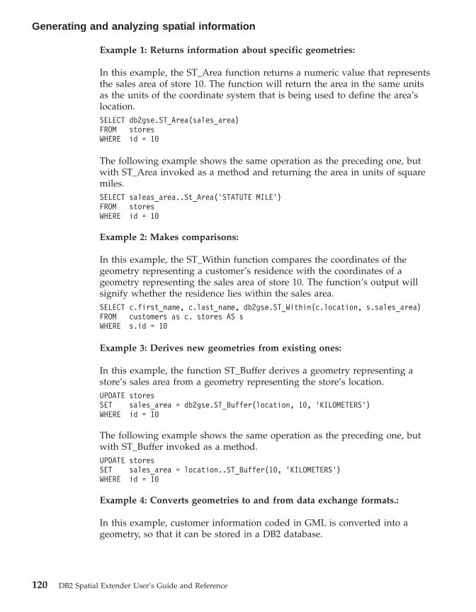
Example 1: Returns information about specific geometries:
In this example, the ST_Area function returns a numeric value that representsthe sales area of store 10. The function will return the area in the same unitsas the units of the coordinate system that is being used to define the area’slocation.SELECT db2gse.ST_Area(sales_area)FROM storesWHERE id = 10
The following example shows the same operation as the preceding one, butwith ST_Area invoked as a method and returning the area in units of squaremiles.SELECT saleas_area..St_Area(’STATUTE MILE’)FROM storesWHERE id = 10
Example 2: Makes comparisons:
In this example, the ST_Within function compares the coordinates of thegeometry representing a customer’s residence with the coordinates of ageometry representing the sales area of store 10. The function’s output willsignify whether the residence lies within the sales area.SELECT c.first_name, c.last_name, db2gse.ST_Within(c.location, s.sales_area)FROM customers as c. stores AS sWHERE s.id = 10
Example 3: Derives new geometries from existing ones:
In this example, the function ST_Buffer derives a geometry representing astore’s sales area from a geometry representing the store’s location.UPDATE storesSET sales_area = db2gse.ST_Buffer(location, 10, ’KILOMETERS’)WHERE id = 10
The following example shows the same operation as the preceding one, butwith ST_Buffer invoked as a method.UPDATE storesSET sales_area = location..ST_Buffer(10, ’KILOMETERS’)WHERE id = 10
Example 4: Converts geometries to and from data exchange formats.:
In this example, customer information coded in GML is converted into ageometry, so that it can be stored in a DB2 database.
Generating and analyzing spatial information
120 DB2 Spatial Extender User’s Guide and Reference
INSERTINTO c.name,c.phoneNo,c.addressVALUES ( 123, ’Mary Anne’, Smith’, db2gse.ST_Point(’<gml:Point><gml:coord><gml=X>-130.876</gml:X><gml:Y>41.120’</gml:Y></gml:coord></gml:Point>, 1) )
Rules for using grid indexes to optimize spatial functions
A specialized group of spatial functions can improve query performance byexploiting a spatial index. Each of these functions compares two geometrieswith one another. If the results of the comparison meet certain criteria, thefunction returns a value of 1; if the results fail to meet the criteria, thefunction returns a value of 0 (zero). If the comparison cannot be performed,the function can return a null.
For example, the function ST_Overlaps compares two geometries that havethe same dimension (for example, two linestrings or two polygons). If thegeometries overlap partway, and if the space covered by the overlap has thesame dimension as the geometries, ST_Overlaps returns a value of 1.
These functions, called comparison functions in the documentation of DB2Spatial Extender, are:v ST_Containsv ST_Crossesv ST_Disjointv ST_EnvIntersectv ST_Equalsv ST_Intersectsv ST_MBRIntersectsv ST_Overlapsv ST_Relatev ST_Touchesv ST_Within
Because of the time and memory required to execute a function, suchexecution can involve considerable processing. Furthermore, the morecomplex the geometries to be compared, the more complex and time-intensivethe comparison will be. The specialized functions listed above can completetheir operations more quickly if they can use a spatial grid index to locategeometries. To enable such a function to use a spatial grid index, observe allof the following rules:v The function must be specified in a WHERE clause. If it is specified in a
SELECT, HAVING, or GROUP BY clause, a grid index cannot be used.
Generating and analyzing spatial information
Chapter 12. Analyzing and Generating spatial information 121
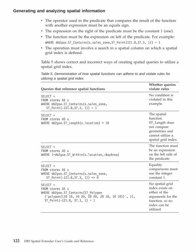
v The operator used in the predicate that compares the result of the functionwith another expression must be an equals sign.
v The expression on the right of the predicate must be the constant 1 (one).v The function must be the expression on left of the predicate. For example:
WHERE db2gse.ST_Contains(s.sales_zone,ST_Point(121.8,37.3, 1)) = 1
v The operation must involve a search in a spatial column on which a spatialgrid index is defined.
Table 5 shows correct and incorrect ways of creating spatial queries to utilize aspatial grid index.
Table 5. Demonstration of how spatial functions can adhere to and violate rules forutilizing a spatial grid index.
Queries that reference spatial functionsWhether queriesviolate rules
SELECT *FROM stores AS sWHERE db2gse.ST_Contains(s.sales_zone,
ST_Point(-121.8,37.3, 1)) = 1
No condition isviolated in thisexample.
SELECT *FROM stores AS sWHERE db2gse.ST_Length(s.location) > 10
The spatialfunctionST_Length doesnot comparegeometries andcannot utilize aspatial grid index.
SELECT *FROM stores AS sWHERE 1=db2gse.ST_Within(s.location,:BayArea)
The function mustbe an expressionon the left side ofthe predicate.
SELECT *FROM stores AS sWHERE db2gse.ST_Contains(s.sales_zone,
ST_Point(-121.8,37.3, 1)) <> 0
Equalitycomparisons mustuse the integerconstant 1.
SELECT *FROM stores AS sWHERE db2gse.ST_Contains(ST_Polygon
(’polygon((10 10, 10 20, 20 20, 20 10, 10 10))’, 1),ST_Point(-121.8, 37.3, 1) = 1
No spatial gridindex exists oneither of thearguments for thefunction, so noindex can beutilized.
Generating and analyzing spatial information
122 DB2 Spatial Extender User’s Guide and Reference

Chapter 13. DB2 Spatial Extender commands
This chapter explains the commands used to set up DB2 Spatial Extender. Italso explains how you use these commands to develop projects.
Invoking commands for setting up DB2 Spatial Extender and developingprojects
You can use a command line processor (CLP), called db2se, to set up SpatialExtender and create projects that use spatial data. This topic explains how touse db2se to run DB2 Spatial Extender commands.
Prerequisites:
Before you can issue db2se commands, you must be authorized to do so. Tofind out what authorization is required for a given command, consult Table 6.for the associated stored procedure topic for the command. For example, thedb2se create_srs command requires the same authorities as thedb2.ST_create_srs stored procedure.
Exception: The db2se shape_info command does not call a stored procedure.Rather, it displays information about the contents of shape files.
Procedure:
Enter db2se commands from an operating system prompt.
To find out what subcommands and parameters you can specify:v Type db2se or db2se -h; then press enter. A list of db2se subcommands is
displayed.v Type db2se and a subcommand, or db2se and a subcommand followed by
-h. Then press enter. The syntax required for the subcommand is displayed.In this syntax:– Each parameter is preceded by a dash and followed by a placeholder for
a parameter value.– Parameters enclosed by brackets are optional. The other parameters are
required.
Important: For your convenience, command syntax can be retrievedinteractively on your monitor; you do not need to look up thesyntax elsewhere.
© Copyright IBM Corp. 1998 - 2002 123

To issue a db2se command, type db2se. Then type a subcommand, followedby the parameters and parameter values that the subcommand requires.Finally, press enter. Be aware that:v You might need to type the user ID and password that give you access to
the database that you just specified. For example, type the ID and passwordif you want to connect to the database as a user other than yourself. Alwaysprecede the ID with the parameter userId and precede the password withthe parameter pw.If you do not specify a user ID and password, your current user ID andpassword will be used by default.
v Values that you enter are not case sensitive by default. To make themcase-sensitive, enclose them in double quotation marks. For example, tospecify the lowercase table name, mytable, type: ″mytable″.Note : you might have to escape the quotation marks to ensure they are notinterpreted by the system prompt (shell), for example, specify:\″myTable\″.\"mytable\"
If a case-sensitive value is qualified by another case-sensitive value, delimitthe two values individually; for example:"myschema"."mytable"
Enclose strings in double quotation marks; for example:"select * from newtable"
When the db2se command is executed, the stored procedure that correspondsto the command will be invoked, and the operation that you requested will beperformed.
Overview of db2se commands:
The following table indicates what db2se commands to issue to perform thetasks involved in setting up Spatial Extender and creating projects that usespatial data. This table also provides examples of db2se commands and refersyou to information about authorizations and command-specific parameters. Tothe right of the task, in the second column, you will see a link or reference toinformation about a stored procedure. This stored procedure is called whenthe command is issued. Authorization to use the stored procedure is the sameas the authorization to use the command; also, the command and storedprocedure share the same parameters. To find out the authorization and themeanings of the parameters, click the link or turn to the section identified bythe reference.
Commands
124 DB2 Spatial Extender User’s Guide and Reference
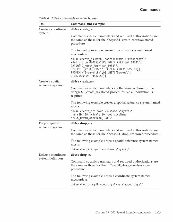
Table 6. db2se commands indexed by task
Task Command and example
Create a coordinatesystem.
db2se create_cs
Command-specific parameters and required authorizations arethe same as those for the db2gse.ST_create_coordsys storedprocedure.
The following example creates a coordinate system namedmycoordsys.
db2se create_cs mydb -coordsysName \"mycoordsys\"-definition GEOCS[\"GCS_NORTH_AMERICAN_1983\",DATUM["D_North_American_1983\",SPHEROID[\"GRS_1980\",6387137,298.257222101]],PRIMEM[\"Greenwich\",0],UNIT["Degree\",0.0174532925199432955]]
Create a spatialreference system.
db2se create_srs
Command-specific parameters are the same as those for thedb2gse.ST_create_srs stored procedure. No authorization isrequired.
The following example creates a spatial reference system namedmysrs.
db2se create_srs mydb -srsName \"mysrs\"-srsID 100 -xScale 10 -coordsysName\"GCS_North_American_1983\"
Drop a spatialreference system.
db2se drop_srs
Command-specific parameters and required authorizations arethe same as those for the db2gse.ST_drop_srs stored procedure.
The following example drops a spatial reference system namedmysrs.
db2se drop_srs mydb -srsName \"mysrs\"
Delete a coordinatesystem definition.
db2se drop_cs
Command-specific parameters and required authorizations arethe same as those for the db2gse.ST_drop_coordsys storedprocedure.
The following example drops a coordinate system namedmycoordsys.
db2se drop_cs mydb -coordsysName \"mycoordsys\"
Commands
Chapter 13. DB2 Spatial Extender commands 125

Table 6. db2se commands indexed by task (continued)
Task Command and example
Disable a setup togeocode dataautomatically.
db2se disable_autogc
Command-specific parameters and required authorizations arethe same as those for the db2gse.ST_disable_autogeocodingstored procedure.
The following example disables the automatic geocoding for ageocoded column named my column in table mytable:
db2se disable_autogc mydb -tableName \mytable\"-columnName \"mycolumn\"
Enable a database forspatial operations.
db2se enable_db
Command-specific parameters and required authorizations arethe same as those for the db2gse.ST_enable_db storedprocedure.
The following example enables a database named mydb forspatial operations.
db2se enable_db mydb
Export data to anSDE transfer file.
db2se export_sde
Command-specific parameters and required authorizations arethe same as those for the db2gse.GSE_export_sde storedprocedure.
The following example exports data from table mySDEtable,which contains spatial column mySpatialcolumn, to an SDEtransfer file named mysdefile.
db2se export_sde mydb -tableName\"mySDEtable\" -columnName \"mySpatialcolumn\"-fileName /home/myaccount/mysdefile
Export data to shapefiles.
db2se export_shape
Command-specific parameters and required authorizations arethe same as those for the db2gse.ST_export_shape storedprocedure.
The following example exports a spatial column namedmycolumn and its associated table mytable to a shape filenamed myshapefile.
db2se export_shape mydb -fileName/home/myaccount/myshapefile -selectStatement"select * from mytable"
Commands
126 DB2 Spatial Extender User’s Guide and Reference

Table 6. db2se commands indexed by task (continued)
Task Command and example
Import an SDEtransfer file.
db2se import_sde
Command-specific parameters and required authorizations arethe same as those for the db2gse.GSE_import_sde storedprocedure.
The following example imports an SDE transfer file namedmysdefile to table mySDEtable, which contains a spatial columnnamed mySpatialcolumn. A commit is to be issued for every tenrecords.
db2se import_sde mydb -tableName \"mysdetable\"-columnName \"mySpatialcolumn\" -fileName/home/myaccount/"mysdefile" -commitScope 10
Importshapshapeefiles.
db2se import_shape
Command-specific parameters and required authorizations arethe same as those for the db2gse.ST_import_shape storedprocedure.
The following command imports a shapefile named myfile to atable named mytable. During the import, the spatial data inmyfile is inserted into a mytable column named mycolumn.
db2se import_shape mydb -fileName \"myfile\"-srsName NAD83_SRS_1 -tableName \"mytable\"-spatialColumnName \"mycolumn\"
Register a geocoder. db2se register_gc
Command-specific parameters and required authorizations arethe same as those for the db2gse.ST_register_geocoder storedprocedure.
The following example registers a geocoder that is namedmygeocoder and that is implemented by a function namedmyschema.myfunction.
db2se register_gc mydb -geocoderName \"mygeocoder"\-functionSchema \"myschema\" -functionName \"myfnction\"-defaultParameterValues "1,’string’,,cast(null as varchar(50))"-vendor myvendor -description "myvendor geocoderreturning well-known text"
Commands
Chapter 13. DB2 Spatial Extender commands 127

Table 6. db2se commands indexed by task (continued)
Task Command and example
Register a spatialcolumn.
db2se register_spatial_column
Command-specific parameters and required authorizations arethe same as those for the db2gse.ST_register_spatial_columnstored procedure.
The following example registers a spatial column namedmycolumn in table mytable with spatial reference systemUSA_SRS_1.
db2se register_spatial_column mydb -tableName\"mytable\" -columnName \"mycolumn\" -srsName USA_SRS_1
Remove theresources that enablea database for spatialoperations.
db2se disable_db
Command-specific parameters and required authorizations arethe same as those for the db2gse.ST_disable_db storedprocedure.
The following example removes the resources that enabledatabase mydb for spatial operations.
db2se disable_db mydb
Remove a set-up forgeocodingoperations.
db2se remove_gc_setup
Command-specific parameters and required authorizations arethe same as those for the db2gse.ST_remove_gc_setup storedprocedure.
The following example removes a set-up for geocodingoperations that apply to a spatial column named mycolumn intable mytable.
db2se remove_geocoding_setup mydb -tableName\"mytable\" -columnName \"mycolumn\"
Run a geocoder inbatch mode.
db2se run_gc
Command-specific parameters and required authorizations arethe same as those for the db2gse.ST_run_gc stored procedure.
The following example runs a geocoder in batch mode topopulate a column named mycolumn in a table named mytable.
db2se run_gc mydb -tableName \"mytable\"-columnName \"mycolumn\"
Commands
128 DB2 Spatial Extender User’s Guide and Reference
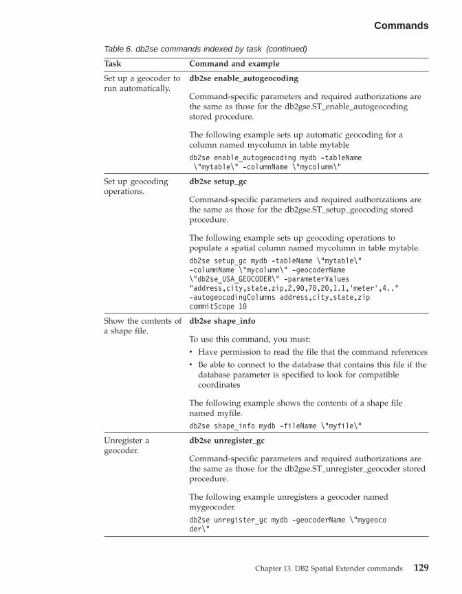
Table 6. db2se commands indexed by task (continued)
Task Command and example
Set up a geocoder torun automatically.
db2se enable_autogeocoding
Command-specific parameters and required authorizations arethe same as those for the db2gse.ST_enable_autogeocodingstored procedure.
The following example sets up automatic geocoding for acolumn named mycolumn in table mytable
db2se enable_autogeocoding mydb -tableName\"mytable\" -columnName \"mycolumn\"
Set up geocodingoperations.
db2se setup_gc
Command-specific parameters and required authorizations arethe same as those for the db2gse.ST_setup_geocoding storedprocedure.
The following example sets up geocoding operations topopulate a spatial column named mycolumn in table mytable.
db2se setup_gc mydb -tableName \"mytable\"-columnName \"mycolumn\" -geocoderName\"db2se_USA_GEOCODER\" -parameterValues"address,city,state,zip,2,90,70,20,1.1,’meter’,4.."-autogeocodingColumns address,city,state,zipcommitScope 10
Show the contents ofa shape file.
db2se shape_info
To use this command, you must:
v Have permission to read the file that the command references
v Be able to connect to the database that contains this file if thedatabase parameter is specified to look for compatiblecoordinates
The following example shows the contents of a shape filenamed myfile.
db2se shape_info mydb -fileName \"myfile\"
Unregister ageocoder.
db2se unregister_gc
Command-specific parameters and required authorizations arethe same as those for the db2gse.ST_unregister_geocoder storedprocedure.
The following example unregisters a geocoder namedmygeocoder.
db2se unregister_gc mydb -geocoderName \"mygeocoder\"
Commands
Chapter 13. DB2 Spatial Extender commands 129

Table 6. db2se commands indexed by task (continued)
Task Command and example
Unregister a spatialcolumn.
db2se unregister_spatial_column
Command-specific parameters and required authorizations arethe same as those for the db2gse.ST_unregister_spatial_columnstored procedure.
The following example unregisters a spatial column namedmycolumn in table mytable.
db2se unregister_spatial_column mydb -tableName\"mytable\" -columnName \"mycolumn\"
Update a coordinatesystem definition.
db2se alter_cs
Command-specific parameters and required authorizations arethe same as those for the db2gse.ST_alter_coordsys storedprocedure.
The following example updates the definition of a coordinatesystem named mycoordsys with a new organization name.
db2se alter_cs mydb -coordsysName \"mycoordsys\"-organization myNeworganizationb -tableName\"mytable\"
Update a spatialreference systemdefinition.
db2se alter_srs
Command-specific parameters and required authorizations arethe same as those for the db2gse.ST_alter_srs stored procedure.
The following example alters a spatial reference system namedmysrs with a different xOffset and description.
db2se alter_srs mydb -srsName \"mysrs\"-xOffset 35 -description "This is myown spatial reference system."
Commands
130 DB2 Spatial Extender User’s Guide and Reference

Chapter 14. Writing applications and using the sampleprogram
This chapter explains how you write Spatial Extender applications.
Writing applications for DB2 Spatial Extender
If you plan to write application programs that invoke DB2 Spatial Extenderstored procedures or functions, read the following task and referenceinformation.
Related concepts:
v “The DB2 Spatial Extender sample program” on page 134
Related tasks:
v “Calling DB2 Spatial Extender stored procedures from an application” onpage 132
v “Including the DB2 Spatial Extender header file in spatial applications” onpage 131
Including the DB2 Spatial Extender header file in spatial applications
DB2 Spatial Extender provides a header file, which defines constants that canbe used with the stored procedures and functions of the DB2 Spatial Extender.
Recommendation: If you plan to call DB2 Spatial Extender stored proceduresor functions from C or C++ programs, include this header file in your spatialapplications.
Procedure:
To ensure that your DB2 Spatial Extender applications can use the necessarydefinitions in this header file:1. Include the DB2 Spatial Extender header file in your application program.
The header file has the following name:db2gse.h
The header file is located in the db2path/include directory, where db2path isthe installation directory where DB2 Universal Database is installed.
© Copyright IBM Corp. 1998 - 2002 131

2. Ensure that the path of the include directory is specified in your makefilewith the compilation option.
Calling DB2 Spatial Extender stored procedures from an application
DB2 Spatial Extender stored procedures are created when you enable thedatabase for spatial operations. If you plan to write application programs thatcall any of the DB2 Spatial Extender stored procedures, you use the SQLCALL statement and specify the name of the stored procedure.
Procedure:
To call DB2 Spatial Extender stored procedures, take the following actions:v To call the ST_enable_db stored procedure, which enables a database for
spatial operations, specify the stored procedure name as follows:CALL db2gse!ST_enable_db
The db2gse! in this call represents the DB2 Spatial Extender library name.The ST_enable_db stored procedure is the only one in which you need toinclude an exclamation mark in the call (that is, db2gse!).
v To call any other DB2 Spatial Extender stored procedure, specify the storedprocedure name in the following form, where db2gse is the schema namefor all DB2 Spatial Extender stored procedures, and spatial_procedure_name isthe name of the stored procedure:CALL db2gse.spatial_procedure_name
Notice that no exclamation mark is included in the preceding call.
The DB2 Spatial Extender stored procedures are shown in the followingtable.
Table 7.
Stored procedure Description
GSE_export_sde Exports a spatial column and itsassociated table to an SDE transfer file.
GSE_import_sde Imports an SDE transfer file to a database.
ST_alter_coordsys Updates an attribute of a coordinatesystem in the database.
ST_alter_srs Updates an attribute of a spatial referencesystem in the database.
ST_create_coordsys Creates a coordinate system in thedatabase.
Writing applications and using the sample program
132 DB2 Spatial Extender User’s Guide and Reference

Table 7. (continued)
ST_create_srs Creates a spatial reference system in thedatabase.
ST_disable_autogeocoding Specifies that DB2 Spatial Extender is tostop synchronizing a geocoded columnwith its associated geocoding columns.
ST_disable_db Removes resources that allow DB2 SpatialExtender to store spatial data and tosupport operations that are performed onthis data.
ST_drop_coordsys Deletes a coordinate system from thedatabase.
ST_drop_srs Deletes a spatial reference system from thedatabase.
ST_enable_autogeocoding Specifies that DB2 Spatial Extender is tosynchronize a geocoded column with itsassociated geocoding columns.
ST_enable_db Supplies a database with the resourcesthat it needs to store spatial data and tosupport operations.
ST_export_shape Exports selected data in the database to ashape file.
ST_import_shape Imports a shape file to a database.
ST_register_geocoder Registers a geocoder other thanDB2SE_USA_GEOCODER, which is partof the DB2 Spatial Extender product.
ST_register_spatial_column Registers a spatial column and associates aspatial reference system with it.
ST_remove_geocoding_setup Removes all the geocoding setupinformation for the geocoded column.
ST_run_geocoding Runs a geocoder in batch mode.
ST_setup_geocoding Associates a column that is to be geocodedwith a geocoder and sets up thecorresponding geocoding parametervalues.
ST_unregister_geocoder Unregisters a geocoder other thanDB2SE_USA_GEOCODER.
ST_unregister_spatial_column Removes the registration of a spatialcolumn.
Writing applications and using the sample program
Chapter 14. Writing applications and using the sample program 133

The DB2 Spatial Extender sample program
The DB2® Spatial Extender sample program, runGseDemo, has two purposes.You can use the sample program to become familiar with applicationprogramming for DB2 Spatial Extender, and you can use the program toverify the DB2 Spatial Extender installation. The steps to verify the DB2Spatial Extender installation are discussed in a separate topic.v On UNIX, you can locate the runGseDemo program in the following path:
$HOME/sqllib/samples/spatial
where $HOME is the instance owner’s home directory.v On Windows, you can locate the runGseDemo program in the following
path:c:\Program Files\IBM\sqllib\samples\spatial
where c:\Program Files\IBM\sqllib is the directory in which you installedDB2 Spatial Extender.
The DB2 Spatial Extender runGseDemo sample program makes applicationprogramming easier. Using this sample program, you will enable a databasefor spatial operations and perform spatial analysis on data in that database.This database will contain tables with customer and flood zone information.From this information you can determine which customers are at risk ofsuffering damage from a flood.
With the sample program, you can:v See the steps typically required to create and maintain a spatially enabled
databasev Understand how to call spatial stored procedures from an application
programv Cut and paste sample code into your own applications
There are additional sample programs available through the DB2 SpatialExtender web site: www.ibm.com/software/data/spatial/
Use the following sample program to code tasks for DB2 Spatial Extender. Forexample, suppose that you write an application that uses the databaseinterface to call DB2 Spatial Extender stored procedures. From the sampleprogram, you can copy code to customize your application. If you areunfamiliar with the programming steps for DB2 Spatial Extender you can runthe sample program, which shows each step in detail. For instructions onrunning the sample program, see the related links at the end of this section.
Writing applications and using the sample program
134 DB2 Spatial Extender User’s Guide and Reference
The following table shows the sample program steps, the associated storedprocedures, and a description of each step. In each step you will perform anaction and in many cases then reverse or undo that action. For example, in thefirst step you will enable the spatial database and then disable the spatialdatabase. In this way, you will become familiar with many of the SpatialExtender stored procedures.
The C functions that invoke the stored procedures are displayed inparentheses. For more information about the stored procedures, see the relatedlinks at the end of this section.
Table 8. DB2 Spatial Extender sample program steps
Steps Action and description
Enable or disable thespatial database
v Enable the spatial database (stEnableDB)
This is the first step needed to use DB2 Spatial Extender.A database that has been enabled for spatial operationshas a set of spatial types, a set of spatial functions, a setof spatial predicates, new index types, and a set of spatialcatalog tables and views.
v Disable the spatial database (stDisableDB)
This step is usually performed when you have enabledspatial capabilities for the wrong database, or you nolonger need to perform spatial operations in this database.When you disable a spatial database, you remove the setof spatial types, the set of spatial functions, the set ofspatial predicates, new index types, and the set of spatialcatalog tables and views associated with that database.
v Enable the spatial database (stEnableDB)
Same as above.
Create or drop acoordinate system
v Create a coordinate system namedNORTH_AMERICAN_TEST (stCreateCS)
This step creates a new coordinate system in the database.
v Drop the coordinate system namedNORTH_AMERICAN_TEST (stDropCS)
This step drops the coordinate systemNORTH_AMERICAN_TEST from the database.
v Create a coordinate system named NORTH_AMERICAN(stCreateCS)
This step creates a new coordinate system,NORTH_AMERICAN, which will be used by the spatialreference system created in the next step.
Writing applications and using the sample program
Chapter 14. Writing applications and using the sample program 135

Table 8. DB2 Spatial Extender sample program steps (continued)
Steps Action and description
Create or drop a spatialreference system
v Create the spatial reference system namedSRSDEMOTEST (stCreateSRS)
This step defines a new spatial reference system (SRS) thatis used to interpret the SRS. The SRS includes geometrydata in a form that can be stored in a column of aspatially enabled database. After the SRS is registered to aspecific spatial column, the coordinates that are applicableto that spatial column can be stored in the associatedCUSTOMERS table column.
v Drop the SRS named SRSDEMOTEST (stDropSRS)
This step is performed if you no longer need the SRS inthe database. When you drop an SRS, you remove the SRSdefinition from the database.
v Create the SRS named SRSDEMO1 (stCreateSRS)
Create and populate thespatial tables
v Create the CUSTOMERS table (sqlSetupTables)
v Populate the CUSTOMERS table (sqlSetupTables)
The CUSTOMERS table represents business data that hasbeen stored in the database for several years.
v Alter the CUSTOMERS table by adding the LOCATIONcolumn (sqlSetupTables)
The ALTER TABLE statement adds a new column(LOCATION) of type ST_Point. This column will bepopulated by geocoding the address columns in asubsequent step.
v Create the OFFICES table (sqlSetupTables)
The OFFICES table represents, among other data, the saleszone for each office of an insurance company. The entiretable will be populated with the attribute data from anon-DB2 database in a subsequent step. This subsequentstep involves importing attribute data into the OFFICEStable from a SHAPE file.
Writing applications and using the sample program
136 DB2 Spatial Extender User’s Guide and Reference
Table 8. DB2 Spatial Extender sample program steps (continued)
Steps Action and description
Populate the columns v Geocode the addresses data for the LOCATION column ofCUSTOMERS table with the geocoder namedDB2SE_USA_GEOCODER (stRunGC)
This step performs batch spatial geocoding by invokingthe geocoder utility. Batch geocoding is usually performedwhen a significant portion of the table needs to begeocoded or re-geocoded.
v Load the previously created OFFICES table from theSHAPE file using SRS SRSDEMO1 (stImportShape)
This step loads the OFFICES table with existing spatialdata in the form of a SHAPE file. Because the OFFICEStable exists, the LOAD utility will append the new recordsto an existing table.
v Create and load the FLOODZONES table from the SHAPEfile using SRS SRSDEMO1 (stImportShape)
This step loads the FLOODZONES table with existingdata in the form of a SHAPE file. Because the table doesnot exist, the LOAD utility will create the table before thedata is loaded.
v Create and load the REGIONS table from the SHAPE fileusing SRS SRSDEMO1 (stImportShape)
Register or unregisterthe geocoder
v Register the geocoder named SAMPLEGC2 (stRegisterGC)
v Unregister the geocoder named SAMPLEGC2(stUnregisterGC)
v Register the geocoder SAMPLEGC (stRegisterGC)
These steps register and unregister the geocoder namedSAMPLEGC2 and then create a new geocoder, SAMPLEGC,to use in the sample program.
Writing applications and using the sample program
Chapter 14. Writing applications and using the sample program 137

Table 8. DB2 Spatial Extender sample program steps (continued)
Steps Action and description
Create spatial indexes v Create the spatial grid index for the LOCATION columnof the CUSTOMERS table (sqlCreateIdx)
v Drop the spatial grid index for the LOCATION column ofthe CUSTOMERS table (sqlDropIdx)
v Create the spatial grid index for the LOCATION columnof the CUSTOMERS table (sqlCreateIdx)
v Create the spatial grid index for the LOCATION columnof the OFFICES table (sqlCreateIdx)
v Create the spatial grid index for the LOCATION columnof the FLOODZONE table (sqlCreateIdx)
v Create the spatial grid index for the LOCATION columnof the REGIONS table (sqlCreateIdx)
These steps create the spatial grid index for theCUSTOMERS, OFFICES, FLOODZONES, and REGIONStables.
Enable automaticgeocoding
v Set up geocoding for the LOCATION column of theCUSTOMERS table with geocoderDB2SE_USA_GEOCODER (stSetupGeocoding)
This step associates the LOCATION column of theCUSTOMERS table with geocoderDB2SE_USA_GEOCODER and sets up the correspondinggeocoding parameter values.
v Enable automatic geocoding for the LOCATION columnof the CUSTOMERS table (stEnableAutoGC)
This step turns on the automatic invocation of thegeocoder. Using automatic geocoding causes theLOCATION, ADDRESS, CITY, STATE, and ZIP columns ofthe CUSTOMERS table to be synchronized with eachother for subsequent insert and update operations.
Insert, update, anddelete operations on theCUSTOMERS table
v Insert some records with a different street (sqlInsDelUpd)
v Update some records with a new address (sqlInsDelUpd)
v Delete all records from the table (sqlInsDelUpd)
These steps demonstrate an insert, update, and deleteoperations on the ADDRESS, CITY, STATE, and ZIP columnsof the CUSTOMERS table. After the automatic geocoding isenabled, data that is inserted or updated in these columnsare automatically geocoded into the LOCATION column.This process was enabled in the previous step.
Writing applications and using the sample program
138 DB2 Spatial Extender User’s Guide and Reference

Table 8. DB2 Spatial Extender sample program steps (continued)
Steps Action and description
Disable automaticgeocoding
v Disable automatic geocoding for the LOCATION columnin the CUSTOMERS table (stDisableAutoGC)
v Remove the geocoding setup for the LOCATION columnof the CUSTOMERS table (stRemoveGeocodingSetup)
v Drop the spatial index for the LOCATION column of theCUSTOMERS table (sqlDropIdx)
These steps disable the automatic invocation of the geocoderand the spatial index in preparation for the next step. Thenext step involves re-geocoding the entire CUSTOMERStable.
Recommendation: If you are loading a large amount ofgeodata, drop the spatial index before you load the data,and then re-create it after the data is loaded.
Re-geocode theCUSTOMERS table
v Geocode the LOCATION column of the CUSTOMERStable again with a lower precision level: 90% instead of100% (stRunGC)
v Re-create the spatial index for the LOCATION column ofthe CUSTOMERS table (sqlCreateIdx)
v Re-enable automatic geocoding with a lower precisionlevel: 90% instead of 100% (stEnableAutoGC)
These steps run the geocoder in batch mode, re-create thespatial index, and re-enable the automatic geocoding with anew precision level. This action is recommended when aspatial administrator notices a high failure rate in thegeocoding process. If the precision level is set to 100%, itmight fail to geocode an address because it cannot find amatching address in the reference data. By reducing theprecision level, the geocoder might be more successful infinding matching data. After the table is re-geocoded inbatch mode, the automatic geocoding is re-enabled and thespatial index is re-created. This facilitates the incrementalmaintenance of the spatial index and the spatial column forsubsequent insert and update operations.
Create a view andregister the spatialcolumn in the view
v Create a view, HIGHRISKCUSTOMERS, based on the joinof the CUSTOMERS table and the FLOODZONE table(sqlCreateView)
v Register the view’s spatial column(stRegisterSpatialColumn)
These steps create a view and register its spatial column.
Writing applications and using the sample program
Chapter 14. Writing applications and using the sample program 139

Table 8. DB2 Spatial Extender sample program steps (continued)
Steps Action and description
Perform spatial analysis v Find the number of customers served by each region(ST_Within)
v For offices and customers with the same region, find thenumber of customers that are within a specific distance ofeach office (ST_Within, ST_Distance)
v For each region, find the average income and premium ofeach customer (ST_Within)
v Find the number of flood zones that each office zoneoverlaps (ST_Overlaps)
v Find the nearest office from a specific customer locationassuming that the office is located in the centriod of theoffice zone (ST_Distance)
v Find the customers whose location is close to theboundary of a specific flood zone (ST_Buffer,ST_Intersects)
v Find those high-risk customers within a specified distancefrom a specific office (ST_Within)
All of these steps use the sqlRunSpatialQueries storedprocedure.
These steps perform spatial analysis using the spatialpredicates and functions in DB2 SQL. The DB2 queryoptimizer exploits the spatial index on the spatial columnsto improve the query performance whenever possible.
Export spatial data intoSHAPE files
v Export the HIGHRISKCUSTOMERS view to SHAPE files(stExportShape)
This step shows an example of exporting theHIGHRISKCUSTOMERS view to SHAPE files. Exportingdata from a database format to another file format enablesthe information to be used by other tools (such asArcExplorer).
This step is included in the runGseDemo.c program but iscommented out for reference only. You can modify thesample program to specify the location for the exportSHAPE file, and rerun the sample program.
Writing applications and using the sample program
140 DB2 Spatial Extender User’s Guide and Reference

Table 8. DB2 Spatial Extender sample program steps (continued)
Steps Action and description
Export and import SDEfiles
v Export the CUSTOMERS table to an SDE transfer file(gseExportSDE)
v Import data from the newly exported SDE transfer file(gseImportSDE)
These steps show examples of exporting and importing SDEtransfer files.
These steps are including in the runGseDemo.c program butare commented out for reference only. You can modify thesample program to specify the location for the exportSHAPE file, and rerun the sample program.
Related tasks:
v “Verifying the Spatial Extender installation” on page 42v “Troubleshooting tips for the installation sample program” on page 44v “Writing applications for DB2 Spatial Extender” on page 131v “Calling DB2 Spatial Extender stored procedures from an application” on
page 132v “Including the DB2 Spatial Extender header file in spatial applications” on
page 131
Writing applications and using the sample program
Chapter 14. Writing applications and using the sample program 141

Writing applications and using the sample program
142 DB2 Spatial Extender User’s Guide and Reference
Chapter 15. Identifying DB2 Spatial Extender problems
If you encounter a problem working with DB2 Spatial Extender, you need todetermine the cause of the problem. You can troubleshoot problems with DB2Spatial Extender in these ways:v You can use message information to diagnose the problem.v When working with Spatial Extender stored procedures and functions, DB2
returns information about the success or failure of the stored procedure orfunction. The information returned will be a message code (in the form ofan integer), message text, or both depending on the interface that you useto work with DB2 Spatial Extender.
v You can view the db2diag.log file, which records diagnostic informationabout errors. The information in this file is intended primarily for an IBMcustomer support representative.
v If you have a recurring and reproducible Spatial Extender problem, an IBMcustomer support representative might ask you to use the DB2 trace facilityto help them diagnose the problem.
This chapter discusses each of these approaches.
How to interpret DB2 Spatial Extender messages
You can work with DB2® Spatial Extender through four different interfaces:v DB2 Spatial Extender stored proceduresv DB2 Spatial Extender functionsv DB2 Spatial Extender Command Line Processor (CLP)v DB2 Control Center
All interfaces return DB2 Spatial Extender messages to help you determinewhether the spatial operation that you requested completed successfully orresulted in an error.
The following table explains each part of this sample DB2 SpatialExtendermessage text:GSE0000I: The operation was completed successfully.
© Copyright IBM Corp. 1998 - 2002 143
Table 9. The parts of the DB2 Spatial Extender message text
Message text part Description
GSE The message identifier. All DB2 Spatial Extender messagesbegin with the three-letter prefix GSE.
0000 The message number. A four digit number that rangesfrom 0000 through 9999.
I The message type. A single letter that indicates theseverity of message:
C Critical error messages
N Non-critical error messages
W Warning messages
I Informational messages
The operation wascompleted successfully.
The message explanation.
The explanation that appears in the message text is the brief explanation. Youcan retrieve additional information about the message that includes thedetailed explanation and suggestions to avoid or correct the problem. Todisplay this additional information:1. Open an operating system command prompt.2. Enter the DB2 help command with the message identifier and message
number to display additional information about the message. For example:DB2 "? GSEnnnn"
where nnnn is the message number.
You can type the GSE message identifier and letter indicating the messagetype in uppercase or lowercase. Typing DB2 ″? GSE0000I″ will yield the sameresult as typing db2 ″? gse0000i″.
You can omit the letter after the message number when you type thecommand. For example, typing DB2 ″? GSE0000″ will yield the same result astyping DB2 ″? GSE0000I″.
Suppose the message code is GSE4107N. When you type DB2 ″? GSE4107N″ atthe command prompt, the following information is displayed:GSE4107N Grid size value "<grid-size>" is not valid where it is used.
Explanation: The specified grid size "<grid-size>" is not valid.
One of the following invalid specifications was made when the grid indexwas created with the CREATE INDEX statement:
Identifying problems
144 DB2 Spatial Extender User’s Guide and Reference

- A number less than 0 (zero) was specified as the grid size for thefirst, second, or third grid level.
- 0 (zero) was specified as the grid size for the first grid level.
- The grid size specified for the second grid level is less than the gridsize of the first grid level but it is not 0 (zero).
- The grid size specified for the third grid level is less than the gridsize of the second grid level but it is not 0 (zero).
- The grid size specified for the third grid level is greater than 0 (zero)but the grid size specified for the second grid level is 0 (zero).
User Response: Specify a valid value for the grid size.
msgcode: -4107
sqlstate: 38SC7
If the information is too long to display on a single screen and your operatingsystem supports the more executable program and pipes, type this command:db2 "? GSEnnnn" | more
Using the more program will force the display to pause after each screen ofdata so that you can read the information.
Related concepts:
v “DB2 Spatial Extender stored procedure output parameters” on page 146v “DB2 Spatial Extender function messages” on page 148v “DB2 Spatial Extender CLP messages” on page 150v “DB2 Control Center messages” on page 153v “The db2diag.log utility” on page 155
Related tasks:
v “Tracing DB2 Spatial Extender problems with the db2trc command” onpage 154
Related reference:
v “GSE messages” in the Message Reference: Volume 1
Identifying problems
Chapter 15. Identifying DB2 Spatial Extender problems 145

DB2 Spatial Extender stored procedure output parameters
DB2® Spatial Extender stored procedures are invoked implicitly when youenable and use Spatial Extender from the DB2 Control Center or when youuse the DB2 Spatial Extender CLP (db2se). You can invoke stored proceduresexplicitly in an application program or from the DB2 command line.
This topic describes how to diagnose problems when stored procedures areinvoked explicitly in application programs or from the DB2 command line. Todiagnose stored procedures invoked implicitly, you use the messages returnedby the DB2 Spatial Extender CLP or the messages returned by the DB2Control Center. These messages are discussed in separate topics.
DB2 Spatial Extender stored procedures have two output parameters: themessage code (msg_code) and the message text (msg_text). The parametervalues indicate the success or failure of a stored procedure.
msg_codeThe msg_code parameter is an integer, which can be positive,negative, or zero (0). Positive numbers are used for warnings, negativenumbers are used for errors (both critical and non-critical), and zero(0) is used for informational messages.
The absolute value of the msg_code is included in the msg_text as themessage number. For examplev If the msg_code is 0, the message number is 0000.v If the msg_code is –219 , the message number is 0219. The negative
msg_code indicates that the message is a critical or non-criticalerror.
v If the msg_code is +1036, the message number is 1036. The positivemsg_code number indicates that the message is a warning.
The msg_code numbers for Spatial Extender stored procedures aredivided into the three categories shown in the following table:
Table 10. Stored procedure message codes
Codes Category
0000 – 0999 Common messages
1000 – 1999 Administrative messages
2000 – 2999 Import and export messages
msg_textThe msg_text parameter is comprised of the message identifier, the
Identifying problems
146 DB2 Spatial Extender User’s Guide and Reference

message number, the message type, and the explanation. An exampleof a stored procedure msg_text value is:GSE0219N An EXECUTE IMMEDIATE statement
failed. SQLERROR = "<sql-error>".
The explanation that appears in the msg_text parameter is the briefexplanation. You can retrieve additional information about themessage that includes the detailed explanation and suggestions toavoid or correct the problem.
For a detailed explanation of the parts of the msg_text parameter, andinformation on how to retrieve additional information about themessage, see the topic: How to interpret DB2 Spatial Extendermessages.
Working with stored procedures in applications:
When you call a DB2 Spatial Extender stored procedure from an application,you will receive the msg_code and msg_text as output parameters. You can:v Program your application to return the output parameter values to the
application user.v Perform some action based on the type of msg_code value returned.
Working with stored procedures from the DB2 command line:
When you invoke a DB2 Spatial Extender stored procedure from the DB2command line, you receive the msg_code and the msg_text outputparameters. These output parameters indicate the success or failure of thestored procedure.
Suppose you connect to a database and want to invoke the ST_disable_dbstored procedure. The example below uses a DB2 CALL command to disablethe database for spatial operations and shows the output value results. A forceparameter value of 0 is used, along with two question marks at the end of theCALL command to represent the msg_code and msg_text output parameters.The values for these output parameters are displayed after the storedprocedure runs.call db2gse.st_disable_db(0, ?, ?)
Value of output parameters--------------------------Parameter Name : MSGCODEParameter Value : 0
Parameter Name : MSGTEXT
Identifying problems
Chapter 15. Identifying DB2 Spatial Extender problems 147

Parameter Value : GSE0000I The operation was completed successfully.
Return Status = 0
Suppose the msg_text returned is GSE2110N. Use the DB2 help command todisplay more information about the message. For example:"? GSE2110"
The following information is displayed:GSE2110N The spatial reference system for the
geomentry in row "<row-number>" is invalid.The spatial reference system’snumerical identifier is "<srs-id>".
Explanation: In row row-number, the geometry that isto be exported uses an invalid spatial reference system.The geometry cannot be exported.
User Response: Correct the indicated geometry orexclude the row from the export operation bymodifying the SELECT statement accordingly.
msg_code: -2110
sqlstate: 38S9A
Related concepts:
v “How to interpret DB2 Spatial Extender messages” on page 143v “DB2 Spatial Extender function messages” on page 148v “DB2 Spatial Extender CLP messages” on page 150v “DB2 Control Center messages” on page 153
Related reference:
v “GSE messages” in the Message Reference: Volume 1
DB2 Spatial Extender function messages
The messages returned by DB2® Spatial Extender functions are typicallyembedded in an SQL message. The SQLCODE returned in the messageindicates if an error occurred with the function or that a warning is associatedwith the function. For example:v The SQLCODE –443 (message number SQL0443) indicates that an error
occurred with the function.v The SQLCODE +462 (message number SQL0462) indicates that a warning is
associated with the function.
Identifying problems
148 DB2 Spatial Extender User’s Guide and Reference
The following table explains the significant parts of this sample message:DB21034E The command was processed as an SQL statement because it wasnot a valid Command Line Processor command. During SQL processing itreturned: SQL0443N Routine "DB2GSE.GSEGEOMFROMWKT"(specific name "GSEGEOMWKT1") has returned an errorSQLSTATE with diagnostic text "GSE3421N Polygon is not closed.".SQLSTATE=38SSL
Table 11. The significant parts of DB2 Spatial Extender function messages
Message part Description
SQL0443N The SQLCODE indicates the type of problem.
GSE3421N The DB2 Spatial Extender message number and messagetype.
The message numbers for functions range from GSE3000 toGSE3999. Additionally, common messages can be returnedwhen you work with DB2 Spatial Extender functions. Themessage numbers for common messages range fromGSE0001 to GSE0999.
Polygon is not closed The DB2 Spatial Extender message explanation.
SQLSTATE=38SSL An SQLSTATE code that further identifies the error. AnSQLSTATE code is returned for each statement or row.
v The SQLSTATE codes for Spatial Extender functionerrors are 38Sxx, where each x is a character letter ornumber.
v The SQLSTATE codes for Spatial Extender functionwarnings are 01HSx, where the x is a character letter ornumber.
An example of an SQL0443 error message:
Suppose that you attempt to insert the values for a polygon into the tablePOLYGON_TABLE, as shown below:INSERT INTO polygon_table ( geometry )VALUES ( ST_Polygon ( ’polygon (( 0 0, 0 2, 2 2, 1 2)) ’) )
This results in an error message because you did not provide the end value toclose the polygon. The error message returned is:DB21034E The command was processed as an SQL statement because it wasnot a valid Command Line Processor command. During SQL processing itreturned: SQL0443N Routine "DB2GSE.GSEGEOMFROMWKT"(specific name "GSEGEOMWKT1") has returned an errorSQLSTATE with diagnostic text "GSE3421N Polygon is not closed.".SQLSTATE=38SSL
Identifying problems
Chapter 15. Identifying DB2 Spatial Extender problems 149

The SQL message number SQL0443N indicates that an error occurred and themessage includes the Spatial Extender message text GSE3421N Polygon is notclosed.
When you receive this type of message:1. Locate the GSE message number within the DB2 or SQL error message.2. Use the DB2 help command (DB2 ?) to see the Spatial Extender message
explanation and user response. Using the above example, type thefollowing command in an operating system command line prompt:DB2 "? GSE3421"
The message is repeated, along with a detailed explanation and recommendeduser response.
Related concepts:
v “How to interpret DB2 Spatial Extender messages” on page 143v “DB2 Spatial Extender stored procedure output parameters” on page 146v “DB2 Spatial Extender CLP messages” on page 150v “DB2 Control Center messages” on page 153
Related reference:
v “GSE messages” in the Message Reference: Volume 1
DB2 Spatial Extender CLP messages
The DB2® Spatial Extender CLP (db2se) returns messages for:v Stored procedures, if invoked implicitly.v Shape information, if you have invoked the shape_info subcommand
program from the DB2 Spatial Extender CLP. These are informationalmessages.
v Migration operations.v Import and export shape operations to and from the client.
Examples of stored procedure messages returned by the DB2 SpatialExtender CLP:
Most of the messages returned through the DB2 Spatial Extender CLP are forDB2 Spatial Extender stored procedures. When you invoke a stored procedurefrom the DB2 Spatial Extender CLP, you will receive message text thatindicates the success or failure of the stored procedure.
Identifying problems
150 DB2 Spatial Extender User’s Guide and Reference
The message text is comprised of the message identifier, the message number,the message type, and the explanation. For example, if you enable a databaseusing the command db2se enable_db testdb, the message text returned bythe Spatial Extender CLP is:Enabling database. Please wait ...
GSE1036W The operation was successful. Butvalues of certain database manager anddatabase configuration parametersshould be increased.
Likewise, if you disable a database using the command db2se disable_dbtestdb the message text returned by the Spatial Extender CLP is:GSE0000I The operation was completed successfully.
The explanation that appears in the message text is the brief explanation. Youcan retrieve additional information about the message that includes thedetailed explanation and suggestions to avoid or correct the problem. Thesteps to retrieve this information, and a detailed explanation of how tointerpret the parts of the message text, are discussed in a separate topic.
If you are invoking stored procedures through an application program orfrom the DB2 command line, there is a separate topic that discussesdiagnosing the output parameters.
Example of shape information messages returned by the Spatial ExtenderCLP:
Suppose you decide to display information for a shape file named office.Through the Spatial Extender CLP (db2se) you would issue this command:db2se shape_info -fileName /tmp/offices
This is an example of the information that displays:
Shape file information----------------------File code = 9994File length (16-bit words) = 484Shape file version = 1000Shape type = 1 (ST_POINT)Number of records = 31
Minimum X coordinate = -87.053834Maximum X coordinate = -83.408752Minimum Y coordinate = 36.939628Maximum Y coordinate = 39.016477Shapes do not have Z coordinates.Shapes do not have M coordinates.
Identifying problems
Chapter 15. Identifying DB2 Spatial Extender problems 151

Shape index file (extension .shx) is present.
Attribute file information--------------------------dBase file code = 3Date of last update = 1901-08-15Number of records = 31Number of bytes in header = 129Number of bytes in each record = 39Number of columns = 3
Column Number Column Name Data Type Length Decimal
1 NAME C ( Character) 16 02 EMPLOYEES N ( Numeric) 11 03 ID N ( Numeric) 11 0
Coordinate system definition: "GEOGCS["GCS_North_American_1983",DATUM["D_North_American_1983",SPHEROID["GRS_1980",6378137,298.257222101]],PRIMEM["Greenwich",0],UNIT["Degree",0.017453292519943295]]"
Examples of migration messages returned by the Spatial Extender CLP:
When you invoke commands that perform migration operations, messages arereturned that indicate the success or failure of that operation.
Suppose you invoke the migration of the database mydb using the commanddb2se migrate mydb -messagesFile /tmp/migrate.msg. The message textreturned by the Spatial Extender CLP is:Migrating database. Please wait ...GSE0000I The operation was completed successfully.
Related concepts:
v “How to interpret DB2 Spatial Extender messages” on page 143v “DB2 Spatial Extender stored procedure output parameters” on page 146v “DB2 Spatial Extender function messages” on page 148v “DB2 Control Center messages” on page 153
Related reference:
v “GSE messages” in the Message Reference: Volume 1
Identifying problems
152 DB2 Spatial Extender User’s Guide and Reference

DB2 Control Center messages
When you work with DB2® Spatial Extender through the DB2 Control Center,messages will appear in the DB2 Message window. Most of the messages thatyou will encounter will be DB2 Spatial Extender messages. Occasionally, youwill receive an SQL message. The SQL messages are returned when an errorinvolves licensing, locking, or when a DAS service is not available. Thefollowing sections provide examples of how DB2 Spatial Extender messagesand SQL messages will appear in the DB2 Control Center.
DB2 Spatial Extender messages:
When you receive a DB2 Spatial Extender message through the ControlCenter, the entire message text appears in the text area of DB2 Messagewindow, for example:GSE0219N An EXECUTE IMMEDIATE statement
failed. SQLERROR = "<sql-error>".
SQL messages:
When you receive an SQL message through the Control Center that pertainsto DB2 Spatial Extender:v The message identifier, message number, and message type appear on the
left side of the DB2 Message window, for example: SQL0612N.v The message text appears in the text area of the DB2 Message window.
The message text that appears in the DB2 Message window might contain theSQL message text and the SQLSTATE, or it might contain the message textand the detailed explanation and user response.
An example of an SQL message that contains the SQL message text and theSQLSTATE is:[IBM][CLI Driver][DB2/NT] SQL0612N "<name>" is a duplicate name. SQLSTATE=42711
An example of an SQL message that contains the message text and thedetailed explanation and user response is:SQL8008NThe product "DB2 Spatial Extender" does not have a validlicense key installed and the evaluation period has expired.
Explanation:
A valid license key could not be found and the evaluationperiod has expired.
User Response:
Identifying problems
Chapter 15. Identifying DB2 Spatial Extender problems 153
Install a license key for the fully entitled version of theproduct. You can obtain a license key for the product bycontacting your IBM® representative or authorized dealer.
Related concepts:
v “How to interpret DB2 Spatial Extender messages” on page 143v “DB2 Spatial Extender stored procedure output parameters” on page 146v “DB2 Spatial Extender function messages” on page 148v “DB2 Spatial Extender CLP messages” on page 150
Related reference:
v “GSE messages” in the Message Reference: Volume 1
Tracing DB2 Spatial Extender problems with the db2trc command
When you have a recurring and reproducible DB2 Spatial Extender problem,you can use the DB2 trace facility to capture information about the problem.The DB2 trace facility is activated by the db2trc system command. The DB2trace facility can:v Trace eventsv Dump the trace data to a filev Format trace data into a readable format
Restrictions:
Activate this facility only when directed by a DB2 technical supportrepresentative.
On UNIX operating systems, you must have SYSADM, SYSCTRL, orSYSMAINT authorization to trace a DB2 instance.
On Windows operating systems, no special authorization is required.
Procedure:
To trace the DB2 Spatial Extender events to memory, you follow these basicsteps:1. Shut down all other applications.2. Turn the trace on. The DB2 Support technical support representative will
provide you with the specific parameters for this step. The basic commandis:db2trc on
Identifying problems
154 DB2 Spatial Extender User’s Guide and Reference
Restriction: The db2trc command must be entered at a operating systemcommand prompt or in a shell script. It cannot be used in the DB2 SpatialExtender command line interface (db2se) or in the DB2 CLP.
You can trace to memory or to a file. The preferred method for tracing isto trace to memory. If the problem being re-created suspends theworkstation and prevents you from dumping the trace, trace to a file.
3. Reproduce the problem.4. Dump the trace to a file, for example:
db2trc dump january23trace.dmp
This command creates a file (january23trace.dmp) in the current directorywith the name that you specify, and dumps the trace information in thatfile.
You can specify a different directory by including the file path. Forexample, to place the dump file in the /tmp/spatial/errors directory, thesyntax is:db2trc dump /tmp/spatial/errors/january23trace.dmp
You should dump the trace immediately after the problem occurs.5. Turn the trace off, for example:
db2trc off
6. Format the data as an ASCII file. You can sort the data two ways:v Use the flw option to sort the data by process or thread, for example:
db2trc flw january23trace.dmp january23trace.flw
v Use the fmt option to list every event chronologically, for example:db2trc fmt january23trace.dmp january23trace.fmt
Related concepts:
v “DB2 trace (db2trc)” in the Troubleshooting Guide
v “How to interpret DB2 Spatial Extender messages” on page 143v “The db2diag.log utility” on page 155
Related reference:
v “GSE messages” in the Message Reference: Volume 1
The db2diag.log utility
Diagnostic information about errors is recorded in the db2diag.log text file.This information is used for problem determination and is intended for DB2®
technical support.
Identifying problems
Chapter 15. Identifying DB2 Spatial Extender problems 155
The db2diag.log and administration notification log are files that contain textinformation logged by DB2 as well as DB2 Spatial Extender. They are locatedin the directory specified by the DIAGPATH database manager configurationparameter. On Windows® NT, Windows 2000, and Windows XP systems, theDB2 administration notification log is found in the event log and can bereviewed through the Windows Event Viewer.
The information that DB2 records in the administration logs is determined bythe DIAGLEVEL and NOTIFYLEVEL settings.
Use a text editor to view the file on the machine where you suspect a problemto have occurred. The most recent events recorded are the furthest down thefile. Generally, each entry contains the following parts:v A timestampv The location reporting the error. Application identifiers allow you to match
up entries pertaining to an application on the logs of servers and clients.v A diagnostic message (usually beginning with ″DIA″ or ″ADM″) explaining
the error.v Any available supporting data, such as SQLCA data structures and pointers
to the location of any extra dump or trap files.
If the database is behaving normally, this type of information is not importantand can be ignored.
The Administration logs grow continuously. When they get too large, backthem up and then erase the file. A new set of files is generated automaticallythe next time they are required by the system.
Related concepts:
v “Interpreting the administration logs” in the Troubleshooting Guide
v “How to interpret DB2 Spatial Extender messages” on page 143
Related tasks:
v “Tracing DB2 Spatial Extender problems with the db2trc command” onpage 154
Related reference:
v “GSE messages” in the Message Reference: Volume 1
Identifying problems
156 DB2 Spatial Extender User’s Guide and Reference

Part 4. Reference material
© Copyright IBM Corp. 1998 - 2002 157

158 DB2 Spatial Extender User’s Guide and Reference

Chapter 16. Stored procedures
This section provides reference information about the stored procedures thatyou can use to set up DB2 Spatial Extender and create projects that use spatialdata. When you set up DB2 Spatial Extender or create projects from the DB2Control Center or the DB2 command line processor, you invoke these storedprocedures implicitly. For example, when you click OK from a DB2 SpatialExtender window in the DB2 Control Center, DB2 calls the stored procedurethat is associated with that window.
Alternatively, you can invoke the stored procedures explicitly in anapplication program.
Before invoking most DB2 Spatial Extender stored procedures on a database,you must enable that database for spatial operations by invoking theST_enable_db stored procedure, either directly or by using the DB2 ControlCenter. (You can read about invoking this stored procedure in the topic aboutST_enable_db, later in this section.)
After a database is enabled for spatial operations, you can invoke any DB2Spatial Extender stored procedure, either implicitly or explicitly, on thatdatabase if you are connected to that database.
This chapter provides topics for all the DB2 Spatial Extender storedprocedures, as follows:v GSE_export_sdev GSE_import_sdev ST_alter_coordsysv ST_alter_srsv ST_create_coordsysv ST_create_srsv ST_disable_autogeocodingv ST_disable_dbv ST_drop_coordsysv ST_drop_srsv ST_enable_autogeocodingv ST_enable_dbv ST_export_shapev ST_import_shape
© Copyright IBM Corp. 1998 - 2002 159
v ST_register_geocoderv ST_register_spatial_columnv ST_remove_geocoding_setupv ST_run_geocodingv ST_setup_geocodingv ST_unregister_geocoderv ST_unregister_spatial_column
The implementations of the stored procedures are archived in the db2gselibrary on the DB2 Spatial Extender server.
GSE_export_sde
Use this stored procedure to export a spatial column and its associated tableto an SDE transfer file.
Restrictions:
v Exactly one spatial column must exist in the table or view.v The spatial column must be registered.v You cannot append to existing SDE files.
Authorization:
The user ID under which the stored procedure is invoked must have eitherSYSADM or DBADM authority. In addition, this user ID under must hold theSELECT privilege on the table that is to be exported.
Syntax:
�� db2gse.GSE_export_sde ( table_schemanull
, table_name , column_name , �
� file_name , where_clausenull
) ��
Parameter descriptions:
table_schemaNames the schema to which the table that is specified in the table_nameparameter belongs. Although you must specify a value for this parameter,the value can be null. If this parameter is null, the value in the CURRENTSCHEMA special register is used as the schema name for the table orview.
Stored procedures
160 DB2 Spatial Extender User’s Guide and Reference
The table_schema value is converted to uppercase unless you enclose it indouble quotation marks.
The data type of this parameter is VARCHAR(128) or, if you enclose thevalue in double quotation marks, VARCHAR(130).
table_nameSpecifies the unqualified name of the table that you are exporting. Youmust specify a non-null value for this parameter.
The table_name value is converted to uppercase unless you enclose it indouble quotation marks.
The data type of this parameter is VARCHAR(128) or, if you enclose thevalue in double quotation marks, VARCHAR(130).
column_nameNames the registered spatial column that you are exporting. You mustspecify a non-null value for this parameter.
The column_name value is converted to uppercase unless you enclose it indouble quotation marks.
The data type of this parameter is VARCHAR(128) or, if you enclose thevalue in double quotation marks, VARCHAR(130).
file_nameNames the SDE transfer file to which the specified spatial column and itsassociated table are to be exported. You must specify a non-null value forthis parameter.
The data type of this parameter is VARCHAR(256).
where_clauseSpecifies the body of the SQL WHERE clause, which defines a restrictionon the set of records that are to be exported. Although you must specify avalue for this parameter, the value can be null. If this parameter is null,no restrictions are defined in the WHERE clause.
If this parameter is specified, the value can reference any attribute columnin the table that you are exporting.
The data type of this parameter is VARCHAR(1024).
Output parameters:
msg_codeSpecifies the message code that is returned from the stored procedure. Thevalue of this output parameter identifies the error, success, or warningcondition that was encountered during the processing of the procedure. Ifthis parameter value is for a success or warning condition, the procedure
GSE_export_sde
Chapter 16. Stored procedures 161

finished its task. If the parameter value is for an error condition, nochanges to the database were performed.
The data type of this output parameter is INTEGER.
msg_textSpecifies the actual message text, associated with the message code, that isreturned from the stored procedure. The message text can includeadditional information about the success, warning, or error condition,such as where an error was encountered.
The data type of this output parameter is VARCHAR(1024).
Example:
This example shows how to use the DB2 command line processor to invokethe GSE_export_sde stored procedure. This example uses a DB2 CALLcommand to export data from a table named CUSTOMERS to SDE files:call db2gse.GSE_export_sde(NULL,’CUSTOMERS’,’LOCATION’,’/tmp/export_sde_file’,
NULL,?,?)
The two question marks at the end of this CALL command represent theoutput parameters, msg_code and msg_text. The values for these outputparameters are displayed after the stored procedure runs.
Related reference:
v “GSE_import_sde” on page 162
GSE_import_sde
Use this stored procedure to import an SDE transfer file to a database that isenabled for spatial operations. The stored procedure can operate in either oftwo ways:v If the SDE transfer file is targeted for an existing table that has a registered
spatial column, DB2 Spatial Extender loads the table with the file’s data.v Otherwise, DB2 Spatial Extender creates a table that has a spatial column,
registers this column, and loads the spatial column and the table’s othercolumns with the file’s data.
The spatial reference system that is specified in the SDE transfer file iscompared with the spatial reference systems that are registered to DB2 SpatialExtender. If the specified system matches a registered system, all data valuesin the transfer data, when loaded, are modified in the way that the registeredsystem specifies. If the specified system matches none of the registeredsystems, DB2 Spatial Extender creates a new spatial reference system tospecify the modifications.
GSE_export_sde
162 DB2 Spatial Extender User’s Guide and Reference

Authorization:
When you import data to an existing table, the user ID under which thisstored procedure is invoked must hold one of the following authorities orprivileges:v SYSADM or DBADM authority on the database that contains the table to
which data is to be importedv CONTROL privilege on this table
When the table to which you want to import data must be created, the userID under which this stored procedure is invoked must hold either SYSADMor DBADM authority on the database that contains the table that is to becreated.
Syntax:
�� db2gse.GSE_import_sde ( table_schemanull
, table_name , column_name , �
� file_name , commit_scopenull
) ��
Parameter descriptions:
table_schemaNames the schema to which the table or view that is specified in thetable_name parameter belongs. Although you must specify a value for thisparameter, the value can be null. If this parameter is null, the value in theCURRENT SCHEMA special register is used as the schema name for thetable or view.
The table_schema value is converted to uppercase unless you enclose it indouble quotation marks.
The data type of this parameter is VARCHAR(128) or, if you enclose thevalue in double quotation marks, VARCHAR(130).
table_nameSpecifies the unqualified name of the table into which the SDE transferdata is to be loaded. You must specify a non-null value for this parameter.
The table_name value is converted to uppercase unless you enclose it indouble quotation marks.
The data type of this parameter is VARCHAR(128) or, if you enclose thevalue in double quotation marks, VARCHAR(130).
column_nameNames the registered column into which the SDE transfer file’s spatialdata is to be loaded. You must specify a non-null value for this parameter.
GSE_import_sde
Chapter 16. Stored procedures 163

The column_name value is converted to uppercase unless you enclose it indouble quotation marks.
The data type of this parameter is VARCHAR(128) or, if you enclose thevalue in double quotation marks, VARCHAR(130).
file_nameNames the SDE transfer file that is to be imported. You must specify anon-null value for this parameter.
The data type of this parameter is VARCHAR(256).
commit_scopeSpecifies the number of records that are to be imported before a COMMITis issued. Although you must specify a value for this parameter, the valuecan be null. If this parameter is null, a value of 0 (zero) is used and norecords are committed.
The data type of this parameter is INTEGER.
Output parameters:
msg_codeSpecifies the message code that is returned from the stored procedure. Thevalue of this output parameter identifies the error, success, or warningcondition that was encountered during the processing of the procedure. Ifthis parameter value is for a success or warning condition, the procedurefinished its task. If the parameter value is for an error condition, nochanges to the database were performed.
The data type of this output parameter is INTEGER.
msg_textSpecifies the actual message text, associated with the message code, that isreturned from the stored procedure. The message text can includeadditional information about the success, warning, or error condition,such as where an error was encountered.
The data type of this output parameter is VARCHAR(1024).
Example:
This example shows how to use the DB2 command line processor to invokethe GSE_import_sde stored procedure. This example uses a DB2 CALLcommand to import an SDE file named tmp/customerSDE into a table namedCUSTOMERS. This CALL command specifies that a COMMIT is to beperformed after every 5 records are imported:call db2gse.GSE_import_sde(NULL,’CUSTOMERS’,’LOCATION’,
’/tmp/customerSde’, 5, ?,?)
GSE_import_sde
164 DB2 Spatial Extender User’s Guide and Reference
The two question marks at the end of this CALL command represent theoutput parameters, msg_code and msg_text. The values for these outputparameters are displayed after the stored procedure runs.
Related reference:
v “GSE_export_sde” on page 160
ST_alter_coordsys
Use this stored procedure to update a coordinate system definition in thedatabase. When this stored procedure is processed, information about thecoordinate system is updated in the DB2GSE.ST_COORDINATE_SYSTEMScatalog view.
Attention: Use care with this stored procedure. If you use this storedprocedure to change the definition of the coordinate system and you haveexisting spatial data that is associated with a spatial reference system that isbased on this coordinate system, you might inadvertently change the spatialdata. If spatial data is affected, you are responsible for ensuring that thechanged spatial data is still accurate and valid.
Authorization:
The user ID under which the stored procedure is invoked must have eitherSYSADM or DBADM authority.
Syntax:
�� db2gse.ST_alter_coordsys ( coordsys_name , definitionnull
, �
� organizationnull
, organization_coordsys_idnull
, descriptionnull
) ��
Parameter descriptions:
coordsys_nameUniquely identifies the coordinate system. You must specify a non-nullvalue for this parameter.
The coordsys_name value is converted to uppercase unless you enclose it indouble quotation marks.
The data type of this parameter is VARCHAR(128) or, if you enclose thevalue in double quotation marks, VARCHAR(130).
definitionDefines the coordinate system. Although you must specify a value for this
GSE_import_sde
Chapter 16. Stored procedures 165

parameter, the value can be null. If this parameter is null, the definition ofthe coordinate system is not changed.
The data type of this parameter is VARCHAR(2048).
organizationNames the organization that defined the coordinate system and providedthe definition for it; for example, ″European Petroleum Survey Group(EPSG).″ Although you must specify a value for this parameter, the valuecan be null.
If this parameter is null, the organization of the coordinate system is notchanged. If this parameter is not null, the organization_coordsys_idparameter cannot be null; in this case, the combination of the organizationand organization_coordsys_id parameters uniquely identifies the coordinatesystem.
The data type of this parameter is VARCHAR(128).
organization_coordsys_idSpecifies a numeric identifier that is assigned to this coordinate system bythe entity listed in the organization parameter. Although you must specifya value for this parameter, the value can be null.
If this parameter is null, the organization parameter must also be null; inthis case, the organization’s coordinate system identifier is not changed. Ifthis parameter is not null, the organization parameter cannot be null; inthis case, the combination of the organization and organization_coordsys_idparameters uniquely identifies the coordinate system.
The data type of this parameter is INTEGER.
descriptionDescribes the coordinate system by explaining its application. Althoughyou must specify a value for this parameter, the value can be null. If thisparameter is null, the description information about the coordinate systemis not changed.
The data type of this parameter is VARCHAR(256).
Output parameters:
msg_codeSpecifies the message code that is returned from the stored procedure. Thevalue of this output parameter identifies the error, success, or warningcondition that was encountered during the processing of the procedure. Ifthis parameter value is for a success or warning condition, the procedurefinished its task. If the parameter value is for an error condition, nochanges to the database were performed.
The data type of this output parameter is INTEGER.
ST_alter_coordsys
166 DB2 Spatial Extender User’s Guide and Reference
msg_textSpecifies the actual message text, associated with the message code, that isreturned from the stored procedure. The message text can includeadditional information about the success, warning, or error condition,such as where an error was encountered.
The data type of this output parameter is VARCHAR(1024).
Example:
This example shows how to use the DB2 command line processor to invokethe ST_alter_coordsys stored procedure. This example uses a DB2 CALLcommand to update a coordinate system named NORTH_AMERICAN_TEST.This CALL command assigns a value of 1002 to the coordsys_id parameter:call db2gse.ST_alter_coordsys(’NORTH_AMERICAN_TEST’,NULL,NULL,1002,NULL,?,?)
The two question marks at the end of this CALL command represent theoutput parameters, msg_code and msg_text. The values for these outputparameters are displayed after the stored procedure runs.
Related reference:
v “ST_create_coordsys” on page 172v “ST_drop_coordsys” on page 186
ST_alter_srs
Use this stored procedure to update a spatial reference system definition inthe database. When this stored procedure is processed, information about thespatial reference system is updated in theDB2GSE.ST_SPATIAL_REFERENCE_SYSTEMS catalog view.
Internally, DB2 Spatial Extender stores the coordinate values as positiveintegers. Thus during computation, the impact of rounding errors (which areheavily dependent on the actual value for floating-point operations) can bereduced. Performance of the spatial operations can also improve significantly.
Restriction: You cannot alter a spatial reference system if a registered spatialcolumn uses that spatial reference system.
Attention: Use care with this stored procedure. If you use this storedprocedure to change offset, scale, or coordsys_name parameters of the spatialreference system, and if you have existing spatial data that is associated withthe spatial reference system, you might inadvertently change the spatial data.If spatial data is affected, you are responsible for ensuring that the changedspatial data is still accurate and valid.
ST_alter_coordsys
Chapter 16. Stored procedures 167

Authorization:
The user ID under which the stored procedure is invoked must have eitherSYSADM or DBADM authority.
Syntax:
�� db2gse.ST_alter_srs ( srs_name , srs_idnull
, x_offsetnull
, �
� x_scalenull
, y_offsetnull
, y_scalenull
, z_offsetnull
, z_scalenull
, �
� m_offsetnull
�
� , m_scalenull
, coordsys_namenull
, descriptionnull
) ��
Parameter descriptions:
srs_nameIdentifies the spatial reference system. You must specify a non-null valuefor this parameter.
The srs_name value is converted to uppercase unless you enclose it indouble quotation marks.
The data type of this parameter is VARCHAR(128) or, if you enclose thevalue in double quotation marks, VARCHAR(130).
srs_idUniquely identifies the spatial reference system. This identifier is used asan input parameter for various spatial functions. Although you mustspecify a value for this parameter, the value can be null. If this parameteris null, the numeric identifier of the spatial reference system is notchanged.
The data type of this parameter is INTEGER.
x_offsetSpecifies the offset for all X coordinates of geometries that are representedin this spatial reference system. Although you must specify a value forthis parameter, the value can be null. If this parameter is null, the valuefor this parameter in the definition of the spatial reference system is notchanged.
The offset is subtracted before the scale factor x_scale is applied whengeometries are converted from external representations (WKT, WKB,shape) to the DB2 Spatial Extender internal representation. (WKT iswell-known text, and WKB is well-known binary.)
ST_alter_srs
168 DB2 Spatial Extender User’s Guide and Reference

The data type of this parameter is DOUBLE.
x_scaleSpecifies the scale factor for all X coordinates of geometries that arerepresented in this spatial reference system. Although you must specify avalue for this parameter, the value can be null. If this parameter is null,the value for this parameter in the definition of the spatial referencesystem is not changed.
The scale factor is applied (multiplication) after the offset x_offset issubtracted when geometries are converted from external representations(WKT, WKB, shape) to the DB2 Spatial Extender internal representation.
The data type of this parameter is DOUBLE.
y_offsetSpecifies the offset for all Y coordinates of geometries that are representedin this spatial reference system. Although you must specify a value forthis parameter, the value can be null. If this parameter is null, the valuefor this parameter in the definition of the spatial reference system is notchanged.
The offset is subtracted before the scale factor y_scale is applied whengeometries are converted from external representations (WKT, WKB,shape) to the DB2 Spatial Extender internal representation.
The data type of this parameter is DOUBLE.
y_scaleSpecifies the scale factor for all Y coordinates of geometries that arerepresented in this spatial reference system. Although you must specify avalue for this parameter, the value can be null. If this parameter is null,the value for this parameter in the definition of the spatial referencesystem is not changed.
The scale factor is applied (multiplication) after the offset y_offset issubtracted when geometries are converted from external representations(WKT, WKB, shape) to the DB2 Spatial Extender internal representation.This scale factor must be the same as x_scale.
The data type of this parameter is DOUBLE.
z_offsetSpecifies the offset for all Z coordinates of geometries that are representedin this spatial reference system. Although you must specify a value forthis parameter, the value can be null. If this parameter is null, the valuefor this parameter in the definition of the spatial reference system is notchanged.
ST_alter_srs
Chapter 16. Stored procedures 169

The offset is subtracted before the scale factor z_scale is applied whengeometries are converted from external representations (WKT, WKB,shape) to the DB2 Spatial Extender internal representation.
The data type of this parameter is DOUBLE.
z_scaleSpecifies the scale factor for all Z coordinates of geometries that arerepresented in this spatial reference system. Although you must specify avalue for this parameter, the value can be null. If this parameter is null,the value for this parameter in the definition of the spatial referencesystem is not changed.
The scale factor is applied (multiplication) after the offset z_offset issubtracted when geometries are converted from external representations(WKT, WKB, shape) to the DB2 Spatial Extender internal representation.
The data type of this parameter is DOUBLE.
m_offsetSpecifies the offset for all M coordinates of geometries that arerepresented in this spatial reference system. Although you must specify avalue for this parameter, the value can be null. If this parameter is null,the value for this parameter in the definition of the spatial referencesystem is not changed.
The offset is subtracted before the scale factor m_scale is applied whengeometries are converted from external representations (WKT, WKB,shape) to the DB2 Spatial Extender internal representation.
The data type of this parameter is DOUBLE.
m_scaleSpecifies the scale factor for all M coordinates of geometries that arerepresented in this spatial reference system. Although you must specify avalue for this parameter, the value can be null. If this parameter is null,the value for this parameter in the definition of the spatial referencesystem is not changed.
The scale factor is applied (multiplication) after the offset m_offset issubtracted when geometries are converted from external representations(WKT, WKB, shape) to the DB2 Spatial Extender internal representation.
The data type of this parameter is DOUBLE.
coordsys_nameUniquely identifies the coordinate system on which this spatial referencesystem is based. The coordinate system must be listed in the viewST_COORDINATE_SYSTEMS. Although you must specify a value for thisparameter, the value can be null. If this parameter is null, the coordinatesystem that is used for this spatial reference system is not changed.
ST_alter_srs
170 DB2 Spatial Extender User’s Guide and Reference

The coordsys_name value is converted to uppercase unless you enclose it indouble quotation marks.
The data type of this parameter is VARCHAR(128) or, if you enclose thevalue in double quotation marks, VARCHAR(130).
descriptionDescribes the spatial reference system by explaining its application.Although you must specify a value for this parameter, the value can benull. If this parameter is null, the description information about the spatialreference system is not changed.
The data type of this parameter is VARCHAR(256).
Output parameters:
msg_codeSpecifies the message code that is returned from the stored procedure. Thevalue of this output parameter identifies the error, success, or warningcondition that was encountered during the processing of the procedure. Ifthis parameter value is for a success or warning condition, the procedurefinished its task. If the parameter value is for an error condition, nochanges to the database were performed.
The data type of this output parameter is INTEGER.
msg_textSpecifies the actual message text, associated with the message code, that isreturned from the stored procedure. The message text can includeadditional information about the success, warning, or error condition,such as where an error was encountered.
The data type of this output parameter is VARCHAR(1024).
Example:
This example shows how to use the DB2 command line processor to invokethe ST_alter_srs stored procedure. This example uses a DB2 CALL commandto change the description parameter value of a spatial reference system namedSRSDEMO:call db2gse.ST_alter_srs(’SRSDEMO’,NULL,NULL,NULL,NULL,NULL,NULL,NULL,NULL,
NULL,NULL,’SRS for GSE Demo Program: offices table’,?,?)
The two question marks at the end of this CALL command represent theoutput parameters, msg_code and msg_text. The values for these outputparameters are displayed after the stored procedure runs.
Related reference:
v “ST_drop_srs” on page 187
ST_alter_srs
Chapter 16. Stored procedures 171

v “ST_create_srs” on page 174
ST_create_coordsys
Use this stored procedure to store information in the database about a newcoordinate system. When this stored procedure is processed, informationabout the coordinate system is added to theDB2GSE.ST_COORDINATE_SYSTEMS catalog view.
Authorization:
The user ID under which the stored procedure is invoked must have eitherSYSADM or DBADM authority.
Syntax:
�� db2gse.ST_create_coordsys ( coordsys_name , definition , organizationnull
�
� , organization_coordsys_idnull
, descriptionnull
) ��
Parameter descriptions:
coordsys_nameUniquely identifies the coordinate system. You must specify a non-nullvalue for this parameter.
The coordsys_name value is converted to uppercase unless you enclose it indouble quotation marks.
The data type of this parameter is VARCHAR(128) or, if you enclose thevalue in double quotation marks, VARCHAR(130).
definitionDefines the coordinate system. You must specify a non-null value for thisparameter. The vendor that supplies the coordinate system usuallyprovides the information for this parameter.
The data type of this parameter is VARCHAR(2048).
organizationNames the organization that defined the coordinate system and providedthe definition for it; for example, ″European Petroleum Survey Group(EPSG).″ Although you must specify a value for this parameter, the valuecan be null.
If this parameter is null, the organization_coordsys_id parameter must alsobe null. If this parameter is not null, the organization_coordsys_id parameter
ST_alter_srs
172 DB2 Spatial Extender User’s Guide and Reference

cannot be null; in this case, the combination of the organization andorganization_coordsys_id parameters uniquely identifies the coordinatesystem.
The data type of this parameter is VARCHAR(128).
organization_coordsys_idSpecifies a numeric identifier. The entity that is specified in theorganization parameter assigns this value. This value is not necessarilyunique across all coordinate systems. Although you must specify a valuefor this parameter, the value can be null.
If this parameter is null, the organization parameter must also be null. Ifthis parameter is not null, the organization parameter cannot be null; inthis case, the combination of the organization and organization_coordsys_idparameters uniquely identifies the coordinate system.
The data type of this parameter is INTEGER.
descriptionDescribes the coordinate system by explaining its application. Althoughyou must specify a value for this parameter, the value can be null. If thisparameter is null, no description information about the coordinate systemis recorded.
The data type of this parameter is VARCHAR(256).
Output parameters:
msg_codeSpecifies the message code that is returned from the stored procedure. Thevalue of this output parameter identifies the error, success, or warningcondition that was encountered during the processing of the procedure. Ifthis parameter value is for a success or warning condition, the procedurefinished its task. If the parameter value is for an error condition, nochanges to the database were performed.
The data type of this output parameter is INTEGER.
msg_textSpecifies the actual message text, associated with the message code, that isreturned from the stored procedure. The message text can includeadditional information about the success, warning, or error condition,such as where an error was encountered.
The data type of this output parameter is VARCHAR(1024).
Example:
ST_create_coordsys
Chapter 16. Stored procedures 173

This example shows how to use the DB2 command line processor to invokethe ST_create_coordsys stored procedure. This example uses a DB2 CALLcommand to create a coordinate system with the following parameter values:v coordsys_name parameter: NORTH_AMERICAN_TESTv definition parameter:
GEOGCS[″GCS_North_American_1983″,DATUM[″D_North_American_1983″,SPHEROID[″GRS_1980″,6378137.0,298.257222101]],PRIMEM[″Greenwich″,0.0],UNIT[″Degree″,0.0174532925199433]]
v organization parameter: EPSGv organization_coordsys_id parameter: 1001v description parameter: Test Coordinate Systemscall db2gse.ST_create_coordsys(’NORTH_AMERICAN_TEST’,
’GEOGCS["GCS_North_American_1983",DATUM["D_North_American_1983",SPHEROID["GRS_1980",6378137.0,298.257222101]],PRIMEM["Greenwich",0.0],UNIT["Degree",0.0174532925199433]]’,’EPSG’,1001,’Test Coordinate Systems’,?,?)
The two question marks at the end of this CALL command represent theoutput parameters, msg_code and msg_text. The values for these outputparameters are displayed after the stored procedure runs.
Related reference:
v “ST_drop_srs” on page 187v “ST_alter_srs” on page 167
ST_create_srs
Use these stored procedures to create a spatial reference system. A spatialreference system is defined by the coordinate system, the precision, and theextents of coordinates that are represented in this spatial reference system. Theextents are the minimum and maximum possible coordinate values for the X,Y, Z, and M coordinates.
Internally, DB2 Spatial Extender stores the coordinate values as positiveintegers. Thus during computation, the impact of rounding errors (which areheavily dependent on the actual value for floating-point operations) can bereduced. Performance of the spatial operations can also improve significantly.
This stored procedure has two variations:v The first variation takes the conversion factors (offsets and scale factors) as
input parameters.
ST_create_coordsys
174 DB2 Spatial Extender User’s Guide and Reference

v The second variation takes the extents and the precision as inputparameters and calculates the conversion factors internally.
This stored procedure replaces db2gse.gse_enable_sref.
Authorization:
None required.
Syntax:
With conversion factors (version 1):
�� db2gse.ST_create_srs ( srs_name , srs_id , x_offsetnull
, x_scale , �
� y_offsetnull
, y_scalenull
, z_offsetnull
, z_scalenull
, m_offsetnull
�
� , m_scalenull
, coordsys_name , descriptionnull
) ��
With maximum possible extend (version 2):
�� db2gse.ST_create_srs ( srs_name , srs_id , x_min , x_max , x_scale , �
� , y_min , y_max y_scalenull
, z_min �
� , z_max , z_scalenull
, m_min , m_max , m_scalenull
, coordsys_name �
� , descriptionnull
��
Parameter descriptions:With conversion factors (version 1):
srs_nameIdentifies the spatial reference system. You must specify a non-null valuefor this parameter.
The srs_name value is converted to uppercase unless you enclose it indouble quotation marks.
The data type of this parameter is VARCHAR(128) or, if you enclose thevalue in double quotation marks, VARCHAR(130).
ST_create_srs
Chapter 16. Stored procedures 175

srs_idUniquely identifies the spatial reference system. This numeric identifier isused as an input parameter for various spatial functions. You must specifya non-null value for this parameter.
The data type of this parameter is INTEGER.
x_offsetSpecifies the offset for all X coordinates of geometries that are representedin this spatial reference system. The offset is subtracted before the scalefactor x_scale is applied when geometries are converted from externalrepresentations (WKT, WKB, shape) to the DB2 Spatial Extender internalrepresentation. (WKT is well-known text, and WKB is well-known binary.)Although you must specify a value for this parameter, the value can benull. If this parameter is null, a value of 0 (zero) is used.
The data type of this parameter is DOUBLE.
x_scaleSpecifies the scale factor for all X coordinates of geometries that arerepresented in this spatial reference system. The scale factor is applied(multiplication) after the offset x_offset is subtracted when geometries areconverted from external representations (WKT, WKB, shape) to the DB2Spatial Extender internal representation. Either the x_offset value isspecified explicitly, or a default x_offset value of 0 is used. You mustspecify a non-null value for this parameter.
The data type of this parameter is DOUBLE.
y_offsetSpecifies the offset for all Y coordinates of geometries that are representedin this spatial reference system. The offset is subtracted before the scalefactor y_scale is applied when geometries are converted from externalrepresentations (WKT, WKB, shape) to the DB2 Spatial Extender internalrepresentation. Although you must specify a value for this parameter, thevalue can be null. If this parameter is the null value, a value of 0 (zero) isused.
The data type of this parameter is DOUBLE.
y_scaleSpecifies the scale factor for all Y coordinates of geometries that arerepresented in this spatial reference system. The scale factor is applied(multiplication) after the offset y_offset is subtracted when geometries areconverted from external representations (WKT, WKB, shape) to the DB2Spatial Extender internal representation. Either the y_offset value isspecified explicitly, or a default y_offset value of 0 is used. Although youmust specify a value for this parameter, the value can be null. If thisparameter is null, the value of the x_scale parameter is used. If you specify
ST_create_srs
176 DB2 Spatial Extender User’s Guide and Reference
a value other than null for this parameter, the value that you specify mustmatch the value of the x_scale parameter.
The data type of this parameter is DOUBLE.
z_offsetSpecifies the offset for all Z coordinates of geometries that are representedin this spatial reference system. The offset is subtracted before the scalefactor z_scale is applied when geometries are converted from externalrepresentations (WKT, WKB, shape) to the DB2 Spatial Extender internalrepresentation. Although you must specify a value for this parameter, thevalue can be null. If this parameter is null, a value of 0 (zero) is used.
The data type of this parameter is DOUBLE.
z_scaleSpecifies the scale factor for all Z coordinates of geometries that arerepresented in this spatial reference system. The scale factor is applied(multiplication) after the offset z_offset is subtracted when geometries areconverted from external representations (WKT, WKB, shape) to the DB2Spatial Extender internal representation. Either the z_offset value isspecified explicitly, or a default z_offset value of 0 is used. Although youmust specify a value for this parameter, the value can be null. If thisparameter is null, a value of 1 is used.
The data type of this parameter is DOUBLE.
m_offsetSpecifies the offset for all M coordinates of geometries that arerepresented in this spatial reference system. The offset is subtracted beforethe scale factor m_scale is applied when geometries are converted fromexternal representations (WKT, WKB, shape) to the DB2 Spatial Extenderinternal representation. Although you must specify a value for thisparameter, the value can be null. If this parameter is null, a value of 0(zero) is used.
The data type of this parameter is DOUBLE.
m_scaleSpecifies the scale factor for all M coordinates of geometries that arerepresented in this spatial reference system. The scale factor is applied(multiplication) after the offset m_offset is subtracted when geometries areconverted from external representations (WKT, WKB, shape) to the DB2Spatial Extender internal representation. Either the m_offset value isspecified explicitly, or a default m_offset value of 0 is used. Although youmust specify a value for this parameter, the value can be null. If thisparameter is null, a value of 1 is used.
The data type of this parameter is DOUBLE.
ST_create_srs
Chapter 16. Stored procedures 177

coordsys_nameUniquely identifies the coordinate system on which this spatial referencesystem is based. The coordinate system must be listed in the viewST_COORDINATE_SYSTEMS. You must supply a non-null value for thisparameter.
The coordsys_name value is converted to uppercase unless you enclose it indouble quotation marks.
The data type of this parameter is VARCHAR(128) or, if you enclose thevalue in double quotation marks, VARCHAR(130).
descriptionDescribes the spatial reference system by explaining the application’spurpose. Although you must specify a value for this parameter, the valuecan be null. If this parameter is null, no description information isrecorded.
The data type of this parameter is VARCHAR(256).
With maximum possible extend (version 2):
srs_nameIdentifies the spatial reference system. You must specify a non-null valuefor this parameter.
The srs_name value is converted to uppercase unless you enclose it indouble quotation marks.
The data type of this parameter is VARCHAR(128) or, if you enclose thevalue in double quotation marks, VARCHAR(130).
srs_idUniquely identifies the spatial reference system. This numeric identifier isused as an input parameter for various spatial functions. You must specifya non-null value for this parameter.
The data type of this parameter is INTEGER.
x_minSpecifies the minimum possible X coordinate value for all geometries thatuse this spatial reference system. You must specify a non-null value forthis parameter.
The data type of this parameter is DOUBLE.
x_maxSpecifies the maximum possible X coordinate value for all geometries thatuse this spatial reference system. You must specify a non-null value forthis parameter.
ST_create_srs
178 DB2 Spatial Extender User’s Guide and Reference
Depending on the value of x_scale, the value that is shown in the viewST_SPATIAL_REFERENCE_SYSTEMS might be larger than the value thatis specified here. The value from the view is correct.
The data type of this parameter is DOUBLE.
x_scaleSpecifies the scale factor for all X coordinates of geometries that arerepresented in this spatial reference system. The scale factor is applied(multiplication) after the offset x_offset is subtracted when geometries areconverted from external representations (WKT, WKB, shape) to the DB2Spatial Extender internal representation. The calculation of the offsetx_offset is based on the x_min value. You must supply a non-null value forthis parameter.
If both the x_scale and y_scale parameters are specified, the values mustmatch.
The data type of this parameter is DOUBLE.
y_minSpecifies the minimum possible Y coordinate value for all geometries thatuse this spatial reference system. You must supply a non-null value forthis parameter.
The data type of this parameter is DOUBLE.
y_maxSpecifies the maximum possible Y coordinate value for all geometries thatuse this spatial reference system. You must supply a non-null value forthis parameter.
Depending on the value of y_scale, the value that is shown in the viewST_SPATIAL_REFERENCE_SYSTEMS might be larger than the value thatis specified here. The value from the view is correct.
The data type of this parameter is DOUBLE.
y_scaleSpecifies the scale factor for all Y coordinates of geometries that arerepresented in this spatial reference system. The scale factor is applied(multiplication) after the offset y_offset is subtracted when geometries areconverted from external representations (WKT, WKB, shape) to the DB2Spatial Extender internal representation. The calculation of the offsety_offset is based on the y_min value. Although you must specify a valuefor this parameter, the value can be null. If this parameter is null, thevalue of the x_scale parameter is used. If both the y_scale and x_scaleparameters are specified, the values must match.
The data type of this parameter is DOUBLE.
ST_create_srs
Chapter 16. Stored procedures 179

z_minSpecifies the minimum possible Z coordinate value for all geometries thatuse this spatial reference system. You must specify a non-null value forthis parameter.
The data type of this parameter is DOUBLE.
z_maxSpecifies the maximum possible Z coordinate value for all geometries thatuse this spatial reference system. You must specify a non-null value forthis parameter.
Depending on the value of z_scale, the value that is shown in the viewST_SPATIAL_REFERENCE_SYSTEMS might be larger than the value thatis specified here. The value from the view is correct.
The data type of this parameter is DOUBLE.
z_scaleSpecifies the scale factor for all Z coordinates of geometries that arerepresented in this spatial reference system. The scale factor is applied(multiplication) after the offset z_offset is subtracted when geometries areconverted from external representations (WKT, WKB, shape) to the DB2Spatial Extender internal representation. The calculation of the offsetz_offset is based on the z_min value. Although you must specify a valuefor this parameter, the value can be null. If this parameter is null, a valueof 1 is used.
The data type of this parameter is DOUBLE.
m_minSpecifies the minimum possible M coordinate value for all geometries thatuse this spatial reference system. You must specify a non-null value forthis parameter.
The data type of this parameter is DOUBLE.
m_maxSpecifies the maximum possible M coordinate value for all geometries thatuse this spatial reference system. You must specify a non-null value forthis parameter.
Depending on the value of m_scale, the value that is shown in the viewST_SPATIAL_REFERENCE_SYSTEMS might be larger than the value thatis specified here. The value from the view is correct.
The data type of this parameter is DOUBLE.
m_scaleSpecifies the scale factor for all M coordinates of geometries that arerepresented in this spatial reference system. The scale factor is applied(multiplication) after the offset m_offset is subtracted when geometries are
ST_create_srs
180 DB2 Spatial Extender User’s Guide and Reference

converted from external representations (WKT, WKB, shape) to the DB2Spatial Extender internal representation. The calculation of the offsetm_offset is based on the m_min value. Although you must specify a valuefor this parameter, the value can be null. If this parameter is null, a valueof 1 is used.
The data type of this parameter is DOUBLE.
coordsys_nameUniquely identifies the coordinate system on which this spatial referencesystem is based. The coordinate system must be listed in the viewST_COORDINATE_SYSTEMS. You must specify a non-null value for thisparameter.
The coordsys_name value is converted to uppercase unless you enclose it indouble quotation marks.
The data type of this parameter is VARCHAR(128) or, if you enclose thevalue in double quotation marks, VARCHAR(130).
descriptionDescribes the spatial reference system by explaining the application’spurpose. Although you must specify a value for this parameter, the valuecan be null. If this parameter is null, no description information isrecorded.
The data type of this parameter is VARCHAR(256).
Output parameters:
msg_codeSpecifies the message code that is returned from the stored procedure. Thevalue of this output parameter identifies the error, success, or warningcondition that was encountered during the processing of the procedure. Ifthis parameter value is for a success or warning condition, the procedurefinished its task. If the parameter value is for an error condition, nochanges to the database were performed.
The data type of this output parameter is INTEGER.
msg_textSpecifies the actual message text, associated with the message code, that isreturned from the stored procedure. The message text can includeadditional information about the success, warning, or error condition,such as where an error was encountered.
The data type of this output parameter is VARCHAR(1024).
Example:
ST_create_srs
Chapter 16. Stored procedures 181

This example shows how to use the DB2 command line processor to invokethe ST_create_srs stored procedure. This example uses a DB2 CALL commandto create a spatial reference system named SRSDEMO with the followingparameter values:v srs_id: 1000000v x_offset: -180v x_scale: 1000000v y_offset: -90v y_scale: 1000000call db2gse.ST_create_srs(’SRSDEMO’,1000000,
-180,1000000, -90, 1000000,0, 1, 0, 1,’NORTH_AMERICAN’,’SRS for GSE Demo Program: customer table’,?,?)
The two question marks at the end of this CALL command represent theoutput parameters, msg_code and msg_text. The values for these outputparameters are displayed after the stored procedure runs.
ST_disable_autogeocoding
Use this stored procedure to specify that DB2 Spatial Extender is to stopsynchronizing a geocoded column with its associated geocoding column orcolumns. A geocoding column is used as input to the geocoder.
This stored procedure replaces db2gse.gse_disable_autogc.
Authorization:
The user ID under which this stored procedure is invoked must have one ofthe following authorities or privileges:v SYSADM or DBADM authority on the database that contains the table on
which the triggers that are being dropped are definedv CONTROL privilege on this tablev ALTER and UPDATE privileges on this table
Note: For CONTROL and ALTER privileges, you must have DROPINauthority on the DB2GSE schema.
Syntax:
�� db2gse.ST_disable_autogeocoding ( table_schemanull
, table_name , �
ST_create_srs
182 DB2 Spatial Extender User’s Guide and Reference

� column_name ) ��
Parameter descriptions:
table_schemaNames the schema to which the table or view that is specified in thetable_name parameter belongs. Although you must specify a value for thisparameter, the value can be null. If this parameter is null, the value in theCURRENT SCHEMA special register is used as the schema name for thetable or view.
The table_schema value is converted to uppercase unless you enclose it inquotation marks.
The data type for this parameter is VARCHAR(128) or, if you enclose thevalue in double quotation marks, VARCHAR(130).
table_nameSpecifies the unqualified name of the table on which the triggers that youwant dropped are defined. You must specify a non-null value for thisparameter.
The table_name value is converted to uppercase unless you enclose it indouble quotation marks.
The data type for this parameter is VARCHAR(128) or, if you enclose thevalue in double quotation marks, VARCHAR(130).
column_nameNames the geocoded column that is maintained by the triggers that youwant dropped. You must specify a non-null value for this parameter.
The column_name value is converted to uppercase unless you enclose it indouble quotation marks.
The data type for this parameter is VARCHAR(128) or, if you enclose thevalue in double quotation marks, VARCHAR(130).
Output parameters:
msg_codeSpecifies the message code that is returned from the stored procedure. Thevalue of this output parameter identifies the error, success, or warningcondition that was encountered during the processing of the procedure. Ifthis parameter value is for a success or warning condition, the procedurefinished its task. If the parameter value is for an error condition, nochanges to the database were performed.
The data type of this output parameter is INTEGER.
msg_textSpecifies the actual message text, associated with the message code, that is
ST_disable_autogeocoding
Chapter 16. Stored procedures 183
returned from the stored procedure. The message text can includeadditional information about the success, warning, or error condition,such as where an error was encountered.
The data type of this output parameter is VARCHAR(1024).
Example:
This example shows how to use the DB2 command line processor to invokethe ST_disable_autogeocoding stored procedure. This example uses a DB2CALL command to disable autogeocoding on the LOCATION column in thetable named CUSTOMERS:call db2gse.ST_disable_autogeocoding(NULL,’CUSTOMERS’,’LOCATION’,?,?)
The two question marks at the end of this CALL command represent theoutput parameters, msg_code and msg_text. The values for these outputparameters are displayed after the stored procedure runs.
Related reference:
v “ST_enable_autogeocoding” on page 189v “ST_setup_geocoding” on page 220
ST_disable_db
Use this stored procedure to remove resources that allow DB2 SpatialExtender to store spatial data and to support operations that are performed onthis data.
This stored procedure helps you resolve problems or issues that arise afteryou enable your database for spatial operations. For example, you mightenable a database for spatial operations and then decide to use anotherdatabase with DB2 Spatial Extender instead. If you did not define any spatialcolumns or import any spatial data, you can invoke this stored procedure toremove all spatial resources from the first database. Because of theinterdependency between spatial columns and the type definitions, youcannot drop the type definitions when columns of those types exist. If youalready defined spatial columns but still want to disable a database for spatialoperations, you must specify a value other than 0 (zero) for the forceparameter to remove all spatial resources in the database that do not haveother dependencies on them.
This stored procedure replaces db2gse.gse_disable_db.
Authorization:
ST_disable_autogeocoding
184 DB2 Spatial Extender User’s Guide and Reference

The user ID under which this stored procedure is invoked must have eitherSYSADM or DBADM authority on the database from which DB2 SpatialExtender resources are to be removed.
Syntax:
�� db2gse.ST_disable_db ( forcenull
) ��
Parameter descriptions:
forceSpecifies that you want to disable a database for spatial operations, eventhough you might have database objects that are dependent on the spatialtypes or spatial functions. Although you must specify a value for thisparameter, the value can be null. If you specify a value other than 0 (zero)or null for the force parameter, the database is disabled, and all resourcesof the DB2 Spatial Extender are removed (if possible). If you specify 0(zero) or null, the database is not disabled if any database objects aredependent on spatial types or spatial functions. Database objects thatmight have such dependencies include tables, views, constraints, triggers,generated columns, methods, functions, procedures, and other data types(subtypes or structured types with a spatial attribute).
The data type of this parameter is SMALLINT.
Output parameters:
msg_codeSpecifies the message code that is returned from the stored procedure. Thevalue of this output parameter identifies the error, success, or warningcondition that was encountered during the processing of the procedure. Ifthis parameter value is for a success or warning condition, the procedurefinished its task. If the parameter value is for an error condition, nochanges to the database were performed.
The data type of this output parameter is INTEGER.
msg_textSpecifies the actual message text, associated with the message code, that isreturned from the stored procedure. The message text can includeadditional information about the success, warning, or error condition,such as where an error was encountered.
The data type of this output parameter is VARCHAR(1024).
Example:
ST_disable_db
Chapter 16. Stored procedures 185

This example shows how to use the DB2 command line processor to invokethe ST_disable_db stored procedure. This example uses a DB2 CALLcommand to disable the database for spatial operations, with a force parametervalue of 1:call db2gse.ST_disable_db(1,?,?)
The two question marks at the end of this CALL command represent theoutput parameters, msg_code and msg_text. The values for these outputparameters are displayed after the stored procedure runs.
Related reference:
v “ST_alter_coordsys” on page 165v “ST_create_coordsys” on page 172
ST_drop_coordsys
Use this stored procedure to delete information about a coordinate systemfrom the database. When this stored procedure is processed, informationabout the coordinate system is removed from theDB2GSE.ST_COORDINATE_SYSTEMS catalog view.
Restriction: You cannot drop a coordinate system on which a spatial referencesystem is based.
Authorization:
The user ID under which the stored procedure is invoked must have eitherSYSADM or DBADM authority.
Syntax:
�� db2gse.ST_drop_coordsys ( coordsys_name ) ��
Parameter descriptions:
coordsys_nameUniquely identifies the coordinate system. You must specify a non-nullvalue for this parameter.
The coordsys_name value is converted to uppercase unless you enclose it indouble quotation marks.
The data type for this parameter is VARCHAR(128) or, if you enclose thevalue in double quotation marks, VARCHAR(130).
Output parameters:
ST_disable_db
186 DB2 Spatial Extender User’s Guide and Reference

msg_codeSpecifies the message code that is returned from the stored procedure. Thevalue of this output parameter identifies the error, success, or warningcondition that was encountered during the processing of the procedure. Ifthis parameter value is for a success or warning condition, the procedurefinished its task. If the parameter value is for an error condition, nochanges to the database were performed.
The data type of this output parameter is INTEGER.
msg_textSpecifies the actual message text, associated with the message code, that isreturned from the stored procedure. The message text can includeadditional information about the success, warning, or error condition,such as where an error was encountered.
The data type of this output parameter is VARCHAR(1024).
Example:
This example shows how to use the DB2 command line processor to invokethe ST_drop_coordsys stored procedure. This example uses a DB2 CALLcommand to delete a coordinate system named NORTH_AMERICAN_TESTfrom the database:call db2gse.ST_drop_coordsys(’NORTH_AMERICAN_TEST’,?,?)
The two question marks at the end of this CALL command represent theoutput parameters, msg_code and msg_text. The values for these outputparameters are displayed after the stored procedure runs.
ST_drop_srs
Use this stored procedure to drop a spatial reference system. When this storedprocedure is processed, information about the spatial reference system isremoved from the DB2GSE.ST_SPATIAL_REFERENCE_SYSTEMS catalogview.
Restriction: You cannot drop a spatial reference system if a spatial columnthat uses that spatial reference system is registered.
Important: Use care when you use this stored procedure. If you use thisstored procedure to drop a spatial reference system, and if any spatial data isassociated with that spatial reference system, you can no longer performspatial operations on the spatial data.
This stored procedure replaces db2gse.gse_disable_sref.
ST_drop_coordsys
Chapter 16. Stored procedures 187

Authorization:
The user ID under which the stored procedure is invoked must have eitherSYSADM or DBADM authority.
Syntax:
�� db2gse.ST_drop_srs ( srs_name ) ��
Parameter descriptions:
srs_nameIdentifies the spatial reference system. You must specify a non-null valuefor this parameter.
The srs_name value is converted to uppercase unless you enclose it indouble quotation marks.
The data type of this parameter is VARCHAR(128) or, if you enclose thevalue in double quotation marks, VARCHAR(130).
Output parameters:
msg_codeSpecifies the message code that is returned from the stored procedure. Thevalue of this output parameter identifies the error, success, or warningcondition that was encountered during the processing of the procedure. Ifthis parameter value is for a success or warning condition, the procedurefinished its task. If the parameter value is for an error condition, nochanges to the database were performed.
The data type of this output parameter is INTEGER.
msg_textSpecifies the actual message text, associated with the message code, that isreturned from the stored procedure. The message text can includeadditional information about the success, warning, or error condition,such as where an error was encountered.
The data type of this output parameter is VARCHAR(1024).
Example:
This example shows how to use the DB2 command line processor to invokethe ST_drop_srs stored procedure. This example uses a DB2 CALL commandto delete a spatial reference system named SRSDEMO:call db2gse.ST_drop_srs(’SRSDEMO’,?,?)
ST_drop_srs
188 DB2 Spatial Extender User’s Guide and Reference

The two question marks at the end of this CALL command represent theoutput parameters, msg_code and msg_text. The values for these outputparameters are displayed after the stored procedure runs.
Related reference:
v “ST_create_srs” on page 174v “ST_alter_srs” on page 167
ST_enable_autogeocoding
Use this stored procedure to specify that DB2 Spatial Extender is tosynchronize a geocoded column with its associated geocoding column orcolumns. A geocoding column is used as input to the geocoder. Each time thatvalues are inserted into, or updated in, the geocoding column or columns,triggers are activated. These triggers invoke the associated geocoder togeocode the inserted or updated values and to place the resulting data in thegeocoded column.
Restriction: You can enable autogeocoding only on tables on which INSERTand UPDATE triggers can be created. Consequently, you cannot enableautogeocoding on views or nicknames.
Prerequisite: Before enabling autogeocoding, you must perform the geocodingsetup step by invoking the ST_setup_geocoding stored procedure. Thegeocoding setup step specifies the geocoder and the geocoding parametervalues. It also identifies the geocoding columns that are to be synchronizedwith the geocoded columns.
This stored procedure replaces db2gse.gse_enable_autogc.
Authorization:
The user ID under which this stored procedure is invoked must have one ofthe following authorities or privileges:v SYSADM or DBADM authority on the database that contains the table on
which the triggers that are created by this stored procedure are definedv CONTROL privilege on the tablev ALTER privilege on the table
If the authorization ID of the statement does not have SYSADM or DBADMauthority, the privileges that the authorization ID of the statement holds(without considering PUBLIC or group privileges) must include all of thefollowing privileges as long as the trigger exists:v SELECT privilege on the table on which autogeocoding is enabled
ST_drop_srs
Chapter 16. Stored procedures 189

v Necessary privileges to evaluate the SQL expressions that are specified forthe parameters in the geocoding setup
Syntax:
�� db2gse.ST_enable_autogeocoding ( table_schemanull
, table_name , �
� column_name ) ��
Parameter descriptions:
table_schemaIdentifies the schema to which the table that is specified in the table_nameparameter belongs. Although you must specify a value for this parameter,the value can be null. If this parameter is null, the value in the CURRENTSCHEMA special register is used as the schema name for the table.
The table_schema value is converted to uppercase unless you enclose it indouble quotation marks.
The data type of this parameter is VARCHAR(128) or, if you enclose thevalue in double quotation marks, VARCHAR(130).
table_nameSpecifies the unqualified name of the table that contains the column intowhich the geocoded data is to be inserted or updated. You must specify anon-null value for this parameter.
The table_name value is converted to uppercase unless you enclose it indouble quotation marks.
The data type of this parameter is VARCHAR(128) or, if you enclose thevalue in double quotation marks, VARCHAR(130).
column_nameIdentifies the column into which the geocoded data is to be inserted orupdated. This column is referred to as the geocoded column. You mustspecify a non-null value for this parameter.
The column_name value is converted to uppercase unless you enclose it indouble quotation marks.
The data type of this parameter is VARCHAR(128) or, if you enclose thevalue in double quotation marks, VARCHAR(130).
Output parameters:
msg_codeSpecifies the message code that is returned from the stored procedure. Thevalue of this output parameter identifies the error, success, or warningcondition that was encountered during the processing of the procedure. If
ST_enable_autogeocoding
190 DB2 Spatial Extender User’s Guide and Reference
this parameter value is for a success or warning condition, the procedurefinished its task. If the parameter value is for an error condition, nochanges to the database were performed.
The data type of this output parameter is INTEGER.
msg_textSpecifies the actual message text, associated with the message code, that isreturned from the stored procedure. The message text can includeadditional information about the success, warning, or error condition,such as where an error was encountered.
The data type of this output parameter is VARCHAR(1024).
Example:
This example shows how to use the DB2 command line processor to invokethe ST_enable_autogeocoding stored procedure. This example uses a DB2CALL command to enable autogeocoding on the LOCATION column in thetable named CUSTOMERS:call db2gse.ST_enable_autogeocoding(NULL,’CUSTOMERS’,’LOCATION’,?,?)
The two question marks at the end of this CALL command represent theoutput parameters, msg_code and msg_text. The values for these outputparameters are displayed after the stored procedure runs.
Related reference:
v “ST_setup_geocoding” on page 220
ST_enable_db
Use this stored procedure to supply a database with the resources that itneeds to store spatial data and to support spatial operations. These resourcesinclude spatial data types, spatial index types, catalog views, suppliedfunctions, and other stored procedures.
This stored procedure replaces db2gse.gse_enable_db.
Authorization:
The user ID under which the stored procedure is invoked must have eitherSYSADM or DBADM authority on the database that is being enabled.
Syntax:
ST_enable_autogeocoding
Chapter 16. Stored procedures 191

�� db2gse.ST_enable_db ( table_creation_parametersnull
) ��
Parameter descriptions:
table_creation_parametersSpecifies any options that are to be added to the CREATE TABLEstatements for the DB2 Spatial Extender catalog tables. Although youmust specify a value for this parameter, the value can be null. If thisparameter is null, no options are added to the CREATE TABLEstatements.
To specify these options, use the syntax of the DB2 CREATE TABLEstatement. For example, to specify a table space in which to create thetables, use:IN tsName INDEX IN indexTsName
The data type of this parameter is VARCHAR(32K).
Output parameters:
msg_codeSpecifies the message code that is returned from the stored procedure. Thevalue of this output parameter identifies the error, success, or warningcondition that was encountered during the processing of the procedure. Ifthis parameter value is for a success or warning condition, the procedurefinished its task. If the parameter value is for an error condition, nochanges to the database were performed.
The data type of this output parameter is INTEGER.
msg_textSpecifies the actual message text, associated with the message code, that isreturned from the stored procedure. The message text can includeadditional information about the success, warning, or error condition,such as where an error was encountered.
The data type of this output parameter is VARCHAR(1024).
Example:
The following example shows how to use Call Level Interface (CLI) to invokethe ST_enable_db stored procedure:SQLHANDLE henv;
SQLHANDLE hdbc;SQLHANDLE hstmt;SQLCHAR uid[MAX_UID_LENGTH + 1];SQLCHAR pwd[MAX_PWD_LENGTH + 1];SQLINTEGER ind[3];SQLINTEGER msg_code = 0;
ST_enable_db
192 DB2 Spatial Extender User’s Guide and Reference
char msg_text[1024] = "";SQLRETURN rc;char *table_creation_parameters = NULL;
/* Allocate environment handle */rc = SQLAllocHandle(SQL_HANDLE_ENV, SQL_NULL_HANDLE, &henv);
/* Allocate database handle */rc = SQLAllocHandle(SQL_HANDLE_DBC, henv, &hdbc);
/* Establish a connection to database "testdb" */rc = SQLConnect(hdbc, (SQLCHAR *)"testdb", SQL_NTS, (SQLCHAR *)uid,SQL_NTS,
(SQLCHAR *)pwd, SQL_NTS);
/* Allocate statement handle */rc = SQLAllocHandle(SQL_HANDLE_STMT, hdbc, &hstmt) ;
/* Associate SQL statement to call the ST_enable_db stored procedure *//* with statement handle and send the statement to DBMS to be prepared. */rc = SQLPrepare(hstmt, "call db2gse!ST_enable_db(?,?,?)", SQL_NTS);
/* Bind 1st parameter marker in the SQL call statement, the input *//* parameter for table creation parameters, to variable *//* table_creation_parameters. */ind[0] = SQL_NULL_DATA;rc = SQLBindParameter(hstmt, 1, SQL_PARAM_OUTPUT, SQL_C_CHAR,
SQL_VARCHAR, 255, 0, table_creation_parameters, 256, &ind[0]);
/* Bind 2nd parameter marker in the SQL call statement, the output *//* parameter for returned message code, to variable msg_code. */ind[1] = 0;rc = SQLBindParameter(hstmt, 2, SQL_PARAM_OUTPUT, SQL_C_LONG,
SQL_INTEGER, 0, 0, &msg_code, 4, &ind[1]);
/* Bind 3rd parameter marker in the SQL call statement, the output *//* parameter returned message text, to variable msg_text. */ind[2] = 0;rc = SQLBindParameter(hstmt, 3, SQL_PARAM_OUTPUT, SQL_C_CHAR,
SQL_VARCHAR, (sizeof(msg_text)-1), 0, msg_text,sizeof(msg_text), &ind[2]);
rc = SQLExecute(hstmt);
Related reference:
v “ST_disable_db” on page 184
ST_enable_db
Chapter 16. Stored procedures 193

ST_export_shape
Use this stored procedure to export a spatial column and its associated tableto a shape file.
This stored procedure replaces db2gse.gse_export_shape.
Authorization:
The user ID under which this stored procedure is invoked must have thenecessary privileges to successfully execute the SELECT statement from whichthe data is to be exported.
The stored procedure, which runs as a process that is owned by the DB2instance owner, must have the necessary privileges on the server machine tocreate or write to the shape files.
Syntax:
�� db2gse.ST_export_shape ( file_name , append_flagnull
, �
� output_column_namesnull
, select_statement , messages_filenull
) ��
Parameter descriptions:
file_nameSpecifies the full path name of a shape file to which the specified data isto be exported. You must specify a non-null value for this parameter.
You can use the ST_export_shape stored procedure to export a new file orto export to an existing file by appending the exported data to it:v If you are exporting to a new file, you can specify the optional file
extension as .shp or .SHP. If you specify .shp or .SHP for the fileextension, DB2 Spatial Extender creates the file with the specifiedfile_name value. If you do not specify the optional file extension, DB2Spatial Extender creates the file that has the name of the file_name valuethat you specify and with an extension of .shp.
v If you are exporting data by appending the data to an existing file, DB2Spatial Extender first looks for an exact match of the name that youspecify for the file_name parameter. If DB2 Spatial Extender does notfind an exact match, it looks first for a file with the .shp extension, andthen for a file with the .SHP extension.
ST_export_shape
194 DB2 Spatial Extender User’s Guide and Reference
If the value of the append_flag parameter indicates that you are notappending to an existing file, but the file that you name in the file_nameparameter already exists, DB2 Spatial Extender returns an error and doesnot overwrite the file.
See “Usage notes” on page 196 for a list of files that are written on theserver machine. The stored procedure, which runs as a process that isowned by the DB2 instance owner, must have the necessary privileges onthe server machine to create or write to the files.
The data type of this parameter is VARCHAR(256).
append_flagIndicates whether the data that is to be exported is to be appended to anexisting shape file. Although you must specify a value for this parameter,the value can be null. Indicate whether you want to append to an existingshape file as follows:v If you want to append data to an existing shape file, specify any value
other than 0 (zero) and null. In this case, the file structure must matchthe exported data; otherwise an error is returned.
v If you want to export to a new file, specify 0 (zero) or null. In this case,DB2 Spatial Extender does not overwrite any existing files.
The data type of this parameter is SMALLINT.
output_column_namesSpecifies one or more column names (separated by commas) that are to beused for non-spatial columns in the output dBASE file. Although youmust specify a value for this parameter, the value can be null. If thisparameter is null, the names that are derived from the SELECT statementare used.
If you specify this parameter but do not enclose column names in doublequotation marks, the column names are converted to uppercase. Thenumber of specified columns must match the number of columns that arereturned from the SELECT statement, as specified in the select_statementparameter, excluding the spatial column.
The data type of this parameter is VARCHAR(32K).
select_statementSpecifies the subselect that returns the data that is to be exported. Thesubselect must reference exactly one spatial column and any number ofattribute columns. You must specify a non-null value for this parameter.
The data type of this parameter is VARCHAR(32K).
messages_fileSpecifies the full path name of the file (on the server machine) that is to
ST_export_shape
Chapter 16. Stored procedures 195

contain messages about the export operation. Although you must specifya value for this parameter, the value can be null. If this parameter is null,no file for DB2 Spatial Extender messages is created.
The messages that are sent to this messages file can be:v Informational messages, such as a summary of the export operationv Error messages for data that could not be exported, for example
because of different coordinate systems
The stored procedure, which runs as a process that is owned by the DB2instance owner, must have the necessary privileges on the server to createthe file.
The data type of this parameter is VARCHAR(256).
Output parameters:
msg_codeSpecifies the message code that is returned from the stored procedure. Thevalue of this output parameter identifies the error, success, or warningcondition that was encountered during the processing of the procedure. Ifthis parameter value is for a success or warning condition, the procedurefinished its task. If the parameter value is for an error condition, nochanges to the database were performed.
The data type of this output parameter is INTEGER.
msg_textSpecifies the actual message text, associated with the message code, that isreturned from the stored procedure. The message text can includeadditional information about the success, warning, or error condition,such as where an error was encountered.
The data type of this output parameter is VARCHAR(1024).
Usage notes:
You can export only one spatial column at a time.
The ST_export_shape stored procedure creates or writes to the following fourfiles:v The main shape file (.shp extension).v The shape index file (.shx extension).v A dBASE file that contains data for non-spatial columns (.dbf extension).
This file is created only if attribute columns actually need to be exportedv A projection file that specifies the coordinate system that is associated with
the spatial data, if the coordinate system is not equal to ″UNSPECIFIED″
ST_export_shape
196 DB2 Spatial Extender User’s Guide and Reference

(.prj extension). The coordinate system is obtained from the first spatialrecord. An error occurs if subsequent records have different coordinatesystems.
The following table describes how DB2 data types are stored in dBASEattribute files. All other DB2 data types are not supported.
Table 12. Storage of DB2 data types in attribute files
SQL type .dbf type .dbf length .dbf decimals Comments
SMALLINT N 6 0
INTEGER N 11 0
BIGINT N 20 0
DECIMAL N precision+2 scale
REAL FLOAT(1)through FLOAT(24)
F 14 6
DOUBLEFLOAT(25) throughFLOAT(53)
F 19 9
CHARACTER,VARCHAR, LONGVARCHAR, andDATALINK
C len 0 length ≤ 255
DATE D 8 0
TIME C 8 0
TIMESTAMP C 26 0
All synonyms for data types and distinct types that are based on the typeslisted in the preceding table are supported.
Example:
This example shows how to use the DB2 command line processor to invokethe ST_export_shape stored procedure. This example uses a DB2 CALLcommand to export all rows from the CUSTOMERS table to a shape file thatis to be created and named /tmp/export_file:call db2gse.ST_export_shape(’/tmp/export_file’,0,NULL,
’select * from customers’,’/tmp/export_msg’,?,?)
The two question marks at the end of this CALL command represent theoutput parameters, msg_code and msg_text. The values for these outputparameters are displayed after the stored procedure runs.
ST_export_shape
Chapter 16. Stored procedures 197

Related reference:
v “ST_import_shape” on page 198
ST_import_shape
Use this stored procedure to import a shape file to a database that is enabledfor spatial operations. The stored procedure can operate in either of two ways,based on the create_table_flag parameter:v DB2 Spatial Extender can create a table that has a spatial column and
attribute columns, and it can then load the table’s columns with the file’sdata.
v Otherwise, the shape and attribute data can be loaded into an existing tablethat has a spatial column and attribute columns that match the file’s data.
This stored procedure replaces db2gse.gse_import_shape.
Authorization:
The owner of the DB2 instance must have the necessary privileges on theserver machine for reading the input files and optionally writing error files.Additional authorization requirements vary based on whether you areimporting into an existing table or into a new table.v When importing into an existing table, the user ID under which this
stored procedure is invoked must hold one of the following authorities orprivileges:– SYSADM or DBADM– CONTROL privilege on the table or view– INSERT and SELECT privilege on the table or view
v When importing into a new table, the user ID under which this storedprocedure is invoked must hold one of the following authorities orprivileges:– SYSADM or DBADM– CREATETAB authority on the database
The user ID must also have one of the following authorities:– IMPLICIT_SCHEMA authority on the database, if the schema name of
the table does not exist– CREATEIN privilege on the schema, if the schema of the table exists
Syntax:
ST_export_shape
198 DB2 Spatial Extender User’s Guide and Reference

�� db2gse.ST_import_shape ( file_name , input_attr_columnsnull
, srs_name , �
� table_schemanull
, table_name , table_attr_columnsnull
, �
� create_table_flagnull
, table_creation_parametersnull
, spatial_column �
� , type_schemanull
, type_namenull
, inline_lengthnull
, id_columnnull
, �
� id_column_is_identitynull
, restart_countnull
, commit_scopenull
, �
� exception_filenull
, messages_filenull
�
� ) ��
Parameter descriptions:
file_nameSpecifies the full path name of the shape file that is to be imported. Youmust specify a non-null value for this parameter.
If you specify the optional file extension, specify either .shp or .SHP. DB2Spatial Extender first looks for an exact match of the specified file name.If DB2 Spatial Extender does not find an exact match, it looks first for afile with the .shp extension, and then for a file with the .SHP extension.
See “Usage notes” on page 206 for a list of required files, which mustreside on the server machine. The stored procedure, which runs as aprocess that is owned by the DB2 instance owner, must have thenecessary privileges on the server to read the files.
The data type of this parameter is VARCHAR(256).
input_attr_columnsSpecifies a list of attribute columns to import from the dBASE file.Although you must specify a value for this parameter, the value can benull. If this parameter is null, all columns are imported. If the dBASE filedoes not exist, this parameter must be the empty string or null.
To specify a non-null value for this parameter, use one of the followingspecifications:v List the attribute column names. The following example shows how to
specify a list of the names of the attribute columns that are to beimported from the dBASE file:N(COLUMN1,COLUMN5,COLUMN3,COLUMN7)
ST_import_shape
Chapter 16. Stored procedures 199

If a column name is not enclosed in double quotation marks, it isconverted to uppercase. Each name in the list must be separated by acomma. The resulting names must exactly match the column names inthe dBASE file.
v List the attribute column numbers. The following example shows howto specify a list of the numbers of the attribute columns that are to beimported from the dBASE file:P(1,5,3,7)
Columns are numbered beginning with 1. Each number in the list mustbe separated by a comma.
v Indicate that no attribute data is to be imported. Specify ″″, which isan empty string that explicitly specifies that DB2 Spatial Extender is toimport no attribute data.
The data type of this parameter is VARCHAR(32K).
srs_nameIdentifies the spatial reference system that is to be used for the geometriesthat are imported into the spatial column. You must specify a non-nullvalue for this parameter.
The spatial column will not be registered. The spatial reference system(SRS) must exist before the data is imported. The import process does notimplicitly create the SRS, but it does compare the coordinate system of theSRS with the coordinate system that is specified in the .prj file (if availablewith the shape file). The import process also verifies that the extents ofthe data in the shape file can be represented in the given spatial referencesystem. That is, the import process verifies that the extents lie within theminimum and maximum possible X, Y, Z, and M coordinates of the SRS.
The srs_name value is converted to uppercase unless you enclose it indouble quotation marks.
The data type for this parameter is VARCHAR(128) or, if you enclose thevalue in double quotation marks, VARCHAR(130).
table_schemaNames the schema to which the table that is specified in the table_nameparameter belongs. Although you must specify a value for this parameter,the value can be null. If this parameter is null, the value in the CURRENTSCHEMA special register is used as the schema name for the table orview.
The table_schema value is converted to uppercase unless you enclose it indouble quotation marks.
The data type for this parameter is VARCHAR(128) or, if you enclose thevalue in double quotation marks, VARCHAR(130).
ST_import_shape
200 DB2 Spatial Extender User’s Guide and Reference

table_nameSpecifies the unqualified name of the table into which the imported shapefile is to be loaded. You must specify a non-null value for this parameter.
The table_name value is converted to uppercase unless you enclose it indouble quotation marks.
The data type for this parameter is VARCHAR(128) or, if you enclose thevalue in double quotation marks, VARCHAR(130).
table_attr_columnsSpecifies the table column names where attribute data from the dBASEfile is to be stored. Although you must specify a value for this parameter,the value can be null. If this parameter is null, the names of the columnsin the dBASE file are used.
If this parameter is specified, the number of names must match thenumber of columns that are imported from the dBASE file. If the tableexists, the column definitions must match the incoming data. See “Usagenotes” on page 206 for an explanation of how attribute data types aremapped to DB2 data types.
The data type of this parameter is VARCHAR(32K).
create_table_flagSpecifies whether the import process is to create a new table. Althoughyou must specify a value for this parameter, the value can be null. If thisparameter is null or any other value other than 0 (zero), a new table iscreated. (If the table already exists, an error is returned.) If this parameteris 0 (zero), no table is created, and the table must already exist.
The data type of this parameter is INTEGER.
table_creation_parametersSpecifies any options that are to be added to the CREATE TABLEstatement that creates a table into which data is to be imported. Althoughyou must specify a value for this parameter, the value can be null. If thisparameter is null, no options are added to the CREATE TABLE statement.
To specify any CREATE TABLE options, use the syntax of the DB2CREATE TABLE statement. For example, to specify a table space in whichto create the tables, specify:IN tsName INDEX IN indexTsName LONG IN longTsName
The data type of this parameter is VARCHAR(32K).
spatial_columnName of the spatial column in the table into which the shape data is to beloaded. You must specify a non-null value for this parameter.
ST_import_shape
Chapter 16. Stored procedures 201

For a new table, this parameter specifies the name of the new spatialcolumn that is to be created. Otherwise, this parameter specifies the nameof an existing spatial column in the table.
The spatial_column value is converted to uppercase unless you enclose it indouble quotation marks.
The data type for this parameter is VARCHAR(128) or, if you enclose thevalue in double quotation marks, VARCHAR(130).
type_schemaSpecifies the schema name of the spatial data type (specified by thetype_name parameter) that is to be used when creating a spatial column ina new table. Although you must specify a value for this parameter, thevalue can be null. If this parameter is null, a value of DB2GSE is used.
The type_schema value is converted to uppercase unless you enclose it indouble quotation marks.
The data type for this parameter is VARCHAR(128) or, if you enclose thevalue in double quotation marks, VARCHAR(130).
type_nameNames the data type that is to be used for the spatial values. Althoughyou must specify a value for this parameter, the value can be null. If thisparameter is null, the data type is determined by the shape file and is oneof the following types:v ST_Pointv ST_MultiPointv ST_MultiLineStringv ST_MultiPolygon
Note that shape files, by definition, allow a distinction only betweenpoints and multipoints, but not between polygons and multipolygons orbetween linestrings and multilinestrings.
If you are importing into a table that does not yet exist, this data type isalso used for the data type of the spatial column. In that case, the datatype can also be a super type of ST_Point, ST_MultiPoint,ST_MultiLineString, or ST_MultiPolygon.
The type_name value is converted to uppercase unless you enclose it indouble quotation marks.
The data type for this parameter is VARCHAR(128) or, if you enclose thevalue in double quotation marks, VARCHAR(130).
inline_lengthSpecifies, for a new table, the maximum number of bytes that are to be
ST_import_shape
202 DB2 Spatial Extender User’s Guide and Reference

allocated for the spatial column within the table. Although you mustspecify a value for this parameter, the value can be null. If this parameteris null, no explicit INLINE LENGTH option is used in the CREATETABLE statement, and DB2 defaults are used implicitly.
Spatial records that exceed this size are stored separately in the LOB tablespace, which might be slower to access.
Typical sizes that are needed for various spatial types are as follows:v One point: 292.v Multipoint, line, or polygon: As large a value as possible. Consider
that the total number of bytes in one row should not exceed the limitfor the page size of the table space for which the table is created.
See the DB2 documentation about the CREATE TABLE SQL statement fora complete description of this value. See also the db2dart utility todetermine the number of inline geometries for existing tables and theability to alter the inline length.
The data type of this parameter is INTEGER.
id_columnNames a column that is to be created to contain a unique number for eachrow of data. (ESRI tools require a column named SE_ROW_ID.) Theunique values for that column are generated automatically during theimport process. Although you must specify a value for this parameter, thevalue can be null if no column (with a unique ID in each row) exists inthe table or if you are not adding such a column to a newly created table.If this parameter is null, no column is created or populated with uniquenumbers.
Restriction: You cannot specify an id_column name that matches the nameof any column in the dBASE file.
The requirements and effect of this parameter depend on whether thetable already exists.v For an existing table, the data type of the id_column parameter can be
any integer type (INTEGER, SMALLINT, or BIGINT).v For a new table that is to be created, the column is added to the table
when the stored procedure creates it. The column will be defined asfollows:INTEGER NOT NULL PRIMARY KEY
If the value of the id_column_is_identity parameter is not null and not 0(zero), the definition is expanded as follows:INTEGER NOT NULL PRIMARY KEY GENERATED ALWAYS AS IDENTITY( START WITH 1 INCREMENT BY 1 )
ST_import_shape
Chapter 16. Stored procedures 203

The id_column value is converted to uppercase unless you enclose it indouble quotation marks.
The data type for this parameter is VARCHAR(128) or, if you enclose thevalue in double quotation marks, VARCHAR(130).
id_column_is_identityIndicates whether the specified id_column is to be created using theIDENTITY clause. Although you must specify a value for this parameter,the value can be null. If this parameter is 0 (zero) or null, the column isnot created as the identity column. If the parameter is any value otherthan 0 or null, the column is created as the identity column. Thisparameter is ignored for tables that already exist.
The data type of this parameter is SMALLINT.
restart_countSpecifies that an import operation is to be started at record n + 1. The firstn records are skipped. Although you must specify a value for thisparameter, the value can be null. If this parameter is null, all records(starting with record number 1) are imported.
The data type of this parameter is INTEGER.
commit_scopeSpecifies that a COMMIT is to be performed after at least n records areimported. Although you must specify a value for this parameter, the valuecan be null. If this parameter is null, a value of 0 (zero) is used, and norecords are committed.
The data type of this parameter is INTEGER.
exception_fileSpecifies the full path name of a shape file in which the shape data thatcould not be imported is stored. Although you must specify a value forthis parameter, the value can be null. If the parameter is null, no files arecreated.
If you specify a value for the parameter and include the optional fileextension, specify either .shp or .SHP. If the extension is null, an extensionof .shp is appended.
The exception file holds the complete block of rows for which a singleinsert statement failed. For example, assume that one row cannot beimported because the shape data is incorrectly encoded. A single insertstatement attempts to import 20 rows, including the one that is in error.Because of the problem with the single row, the entire block of 20 rows iswritten to the exception file.
Records are written to the exception file only when those records can becorrectly identified, as is the case when the shape record type is not valid.
ST_import_shape
204 DB2 Spatial Extender User’s Guide and Reference
Some types of corruption to the shape data (.shp files) and shape index(.shx files) do not allow the appropriate records to be identified. In thiscase, no records are written to the exception file, and an error message isissued to report the problem.
If you specify a value for this parameter, four files are created on theserver machine. See “Usage notes” on page 206 for an explanation thesefiles. The stored procedure, which runs as a process that is owned by theDB2 instance owner, must have the necessary privileges on the server tocreate the files. If the files already exist, the stored procedure returns anerror.
The data type of this parameter is VARCHAR(256).
messages_fileSpecifies the full path name of the file (on the server machine) that is tocontain messages about the import operation. Although you must specifya value for this parameter, the value can be null. If the parameter is null,no file for DB2 Spatial Extender messages is created.
The messages that are written to the messages file can be:v Informational messages, such as a summary of the import operationv Error messages for data that could not be imported, for example
because of different coordinate systems
These messages correspond to the shape data that is stored in theexception file (identified by the exception_file parameter).
The stored procedure, which runs as a process that is owned by the DB2instance owner, must have the necessary privileges on the server to createthe file. If the file already exists, the stored procedure returns an error.
The data type of this parameter is VARCHAR(256).
Output parameters:
msg_codeSpecifies the message code that is returned from the stored procedure. Thevalue of this output parameter identifies the error, success, or warningcondition that was encountered during the processing of the procedure. Ifthis parameter value is for a success or warning condition, the procedurefinished its task. If the parameter value is for an error condition, nochanges to the database were performed.
The data type of this output parameter is INTEGER.
msg_textSpecifies the actual message text, associated with the message code, that isreturned from the stored procedure. The message text can include
ST_import_shape
Chapter 16. Stored procedures 205

additional information about the success, warning, or error condition,such as where an error was encountered.
The data type of this output parameter is VARCHAR(1024).
Usage notes:
The ST_import_shape stored procedure uses from one to four files:v The main shape file (.shp extension). This file is required.v The shape index file (.shx extension). This file is optional. If it is present,
performance of the import operation might improve.v A dBASE file that contains attribute data (.dbf extension). This file is
required only if attribute data is to be imported.v The projection file that specifies the coordinate system of the shape data
(.prj extension). This file is optional. If this file is present, the coordinatesystem that is defined in it is compared with the coordinate system of thespatial reference system that is specified by the srs_id parameter.
The following table describes how dBASE attribute data types are mapped toDB2 data types. All other attribute data types are not supported.
Table 13. Relationship between DB2 data types and dBASE attribute data types
.dbf type.dbf length� (Seenote)
.dbf decimals�(See note) SQL type Comments
N < 5 0 SMALLINT
N < 10 0 INTEGER
N < 20 0 BIGINT
N len dec DECIMAL(len,dec) len<32
F len dec REAL len + dec < 7
F len dec DOUBLE
C len CHAR(len)
L CHAR(1)
D DATE
Note: This table includes the following variables, both of which are defined inthe header of the dBASE file:v len, which represents the total length of the column in the dBASE
file. DB2 Spatial Extender uses this value for two purposes:– To define the precision for the SQL data type DECIMAL or the
length for the SQL data type CHAR
ST_import_shape
206 DB2 Spatial Extender User’s Guide and Reference
– To determine which of the integer or floating-point types is to beused
v dec, which represents the maximum number of digits to the right ofthe decimal point of the column in the dBASE file. DB2 SpatialExtender uses this value to define the scale for the SQL data typeDECIMAL.
For example, assume that the dBASE file contains a column of datawhose length (len) is defined as 20. Assume that the number of digits tothe right of the decimal point (dec) is defined as 5. When DB2 SpatialExtender imports data from that column, it uses the values of len anddec to derive the following SQL data type: DECIMAL(20,5).
Example:
This example shows how to use the DB2 command line processor to invokethe ST_import_shape stored procedure. This example uses a DB2 CALLcommand to import a shape file named /tmp/officesShape into the tablenamed OFFICES:call db2gse.ST_import_shape(’/tmp/officesShape’,NULL,’USA_SRS_1’,NULL,
’OFFICES’,NULL,0,NULL,’LOCATION’,NULL,NULL,NULL,NULL,NULL,NULL,NULL,NULL,’/tmp/import_msg’,?,?)
The two question marks at the end of this CALL command represent theoutput parameters, msg_code and msg_text. The values for these outputparameters are displayed after the stored procedure runs.
Related reference:
v “ST_export_shape” on page 194
ST_register_geocoder
Use this stored procedure to register a geocoder other than theDB2SE_USA_GEOCODER geocoder, which is shipped with DB2 SpatialExtender. The DB2SE_USA_GEOCODER geocoder is registered by DB2 SpatialExtender when the database is enabled.
Prerequisites: Before registering a geocoder:v Ensure that the function that implements the geocoder is already created.
Each geocoder function can be registered as a geocoder with a uniquelyidentified geocoder name.
v Obtain information from the geocoder vendor, such as:– The SQL statement that creates the function
ST_import_shape
Chapter 16. Stored procedures 207

– The values to use with the ST_create_srs parameters so that geometricdata can be supported
– Information for registering the geocoder, such as:- A description of the geocoder- Descriptions of the parameters for the geocoder- The default values of the geocoder parameters
The geocoder function’s return type must match the data type of thegeocoded column. The geocoding parameters can be either a column name(called a geocoding column) which contains data that the geocoder needs. Forexample, the geocoder parameters can identify addresses or a value ofparticular meaning to the geocoder, such as the minimum match score. If thegeocoding parameter is a column name, the column must be in the same tableor view as the geocoded column.
The geocoder function’s return type serves as the data type for the geocodedcolumn. The return type can be any DB2 data type, user-defined type, orstructured type. If a user-defined type or structured type is returned, thegeocoder function is responsible for returning a valid value of the respectivedata type. If the geocoder function returns values of a spatial type, that isST_Geometry or one of its subtypes, the geocoder function is responsible forconstructing a valid geometry. The geometry must be represented using anexisting spatial reference system. The geometry is valid if you invoke theST_IsValid spatial function on the geometry and a value of 1 is returned. Thereturned data from the geocoder function is updated in or is inserted into thegeocoded column, depending on which operation (INSERT or UPDATE)caused the generation of the geocoded value.
To find out whether a geocoder is already registered, examine theDB2GSE.ST_GEOCODERS catalog view.
This stored procedure replaces db2gse.gse_register_gc.
Authorization:
The user ID under which this stored procedure is invoked must hold eitherSYSADM or DBADM authority on the database that contains the geocoderthat this stored procedure registers.
Syntax:
�� db2gse.ST_register_geocoder ( geocoder_name , function_schemanull
, �
ST_register_geocoder
208 DB2 Spatial Extender User’s Guide and Reference

� function_namenull
, specific_namenull
, default_parameter_valuesnull
, �
� parameter_descriptionsnull
, vendornull
, descriptionnull
) ��
Parameter descriptions:
geocoder_nameUniquely identifies the geocoder. You must specify a non-null value forthis parameter.
The geocoder_name value is converted to uppercase unless you enclose it indouble quotation marks.
The data type of this parameter is VARCHAR(128) or, if you enclose thevalue in double quotation marks, VARCHAR(130).
function_schemaNames the schema for the function that implements this geocoder.Although you must specify a value for this parameter, the value can benull. If this parameter is null, the value in the CURRENT SCHEMAspecial register is used as the schema name for the function.
The function_schema value is converted to uppercase unless you enclose itin double quotation marks.
The data type of this parameter is VARCHAR(128) or, if you enclose thevalue in double quotation marks, VARCHAR(130).
function_nameSpecifies the unqualified name of the function that implements thisgeocoder. The function must already be created and listed inSYSCAT.ROUTINES.
For this parameter, you can specify null if the specific_name parameter isspecified. If the specific_name parameter is not specified, the function_namevalue, together with the implicitly or explicitly defined function_schemavalue, must uniquely identify the function. If the function_name parameteris not specified, DB2 Spatial Extender retrieves the function_name valuefrom the SYSCAT.ROUTINES catalog view.
The function_name value is converted to uppercase unless you enclose it indouble quotation marks.
The data type of this parameter is VARCHAR(128) or, if you enclose thevalue in double quotation marks, VARCHAR(130).
specific_nameIdentifies the specific name of the function that implements the geocoder.The function must already be created and listed in SYSCAT.ROUTINES.
ST_register_geocoder
Chapter 16. Stored procedures 209
For this parameter, you can specify null if the function_name parameter isspecified and the combination of function_schema and function_nameuniquely identifies the geocoder function. If the geocoder function name isoverloaded, the specific_name parameter cannot be null. (A function nameis overloaded if it has the same name, but not the same parameters orparameter data types, as one or more other functions.)
The specific_name value is converted to uppercase unless you enclose it indouble quotation marks.
The data type of this parameter is VARCHAR(128) or, if you enclose thevalue in double quotation marks, VARCHAR(130).
default_parameter_valuesSpecifies the list of default geocoding parameter values for the geocoderfunction. Although you must specify a value for this parameter, the valuecan be null. If the entire default_parameter_values parameter is null, allparameter default values are null.
If you specify any parameter values, specify them in the order that thefunction defined them, and separate them with a comma. For example:default_parm1_value,default_parm2_value,...
Each parameter value is an SQL expression. Follow these guidelines:v If a value is a string, enclose it in single quotation marks.v If a parameter value is a number, do not enclose it in single quotation
marks.v If the parameter value is null, cast it to the correct type. For example,
instead of specifying just NULL, specify:CAST(NULL AS INTEGER)
v If the geocoding parameter is to be a geocoding column, do not specifythe default parameter value.
If any parameter value is not specified (that is, if you specify twoconsecutive commas (...,,...)), this parameter must be specified eitherwhen geocoding is set up or when geocoding is run in batch mode withthe parameter_values parameter of the respective stored procedures.
The data type of this parameter is VARCHAR(32K).
parameter_descriptionsSpecifies the list of geocoding parameter descriptions for the geocoderfunction. Although you must specify a value for this parameter, the valuecan be null.
If the entire parameter_descriptions parameter is null, all parameterdescriptions are null. Each parameter description that you specify explainsthe meaning and usage of the parameter, and can be up to 256 characters
ST_register_geocoder
210 DB2 Spatial Extender User’s Guide and Reference

long. The descriptions for the parameters must be separated by commasand must appear in the order of the parameters as defined by thefunction. If a comma shall be used within the description of a parameter,enclose the string in single or double quotation marks. For example:description,’description2, which contains a comma’,description3
The data type of this parameter is VARCHAR(32K).
vendorNames the vendor who implemented the geocoder. Although you mustspecify a value for this parameter, the value can be null. If this parameteris null, no information about the vendor who implemented the geocoderis recorded.
The data type of this parameter is VARCHAR(128).
descriptionDescribes the geocoder by explaining its application. Although you mustspecify a value for this parameter, the value can be null. If this parameteris null, no description information about the geocoder is recorded.
Recommendation: Include the following information:v Coordinate system name if spatial data, such as well-known text (WKT)
or well-known binary (WKB), is to be returnedv Spatial reference system, if ST_Geometry or any of its subtypes are to
be returnedv Name of the geographical area to which this geocoder appliesv Any other information about the geocoder that users should know
The data type of this parameter is VARCHAR(256).
Output parameters:
msg_codeSpecifies the message code that is returned from the stored procedure. Thevalue of this output parameter identifies the error, success, or warningcondition that was encountered during the processing of the procedure. Ifthis parameter value is for a success or warning condition, the procedurefinished its task. If the parameter value is for an error condition, nochanges to the database were performed.
The data type of this output parameter is INTEGER.
msg_textSpecifies the actual message text, associated with the message code, that isreturned from the stored procedure. The message text can includeadditional information about the success, warning, or error condition,such as where an error was encountered.
ST_register_geocoder
Chapter 16. Stored procedures 211

The data type of this output parameter is VARCHAR(1024).
Example:
This example assumes that you want to create a geocoder that takes latitudeand longitude as input and geocodes into ST_Point spatial data. To do this,you first create a function named lat_long_gc_func. Then you register ageocoder named SAMPLEGC, which uses the function lat_long_gc_func.
Here is an example of the SQL statement that creates the functionlat_long_gc_func that returns ST_Point:CREATE FUNCTION lat_long_gc_func(latitude double,
longitude double, srId integer)RETURNS db2gse.ST_PointLANGUAGE SQLRETURN db2gse.ST_Point(latitude, longitude, srId)
After the function is created, you can register it as a geocoder. This exampleshows how to use the DB2 command line processor CALL command toinvoke the ST_register_geocoder stored procedure to register a geocodernamed SAMPLEGC with function lat_long_gc_func:call db2gse.ST_register_geocoder (’SAMPLEGC’,NULL,’LAT_LONG_GC_FUNC’,’,,1’
,NULL,’My Company’,’Latitude/Longitude toST_Point Geocoder’?,?)
The two question marks at the end of this CALL command represent theoutput parameters, msg_code and msg_text. The values for these outputparameters are displayed after the stored procedure runs.
Related reference:
v “ST_unregister_geocoder” on page 224
ST_register_spatial_column
Use this stored procedure to register a spatial column and to associate aspatial reference system (SRS) with it. When this stored procedure isprocessed, information about the spatial column that is being registered isadded to the DB2GSE.ST_GEOMETRY_COLUMNS catalog view. Registering aspatial column creates a constraint on the table, if possible, to ensure that allgeometries use the specified SRS.
This stored procedure replaces db2gse.gse_register_layer.
Authorization:
ST_register_geocoder
212 DB2 Spatial Extender User’s Guide and Reference
The user ID under which this stored procedure is invoked must hold one ofthe following authorities or privileges:v SYSADM or DBADM authority on the database that contains the table to
which the spatial column that is being registered belongsv CONTROL or ALTER privilege on this table
Syntax:
�� db2gse.ST_register_spatial_column ( table_schemanull
, table_name , �
� column_name , srs_name ) ��
Parameter descriptions:
table_schemaNames the schema to which the table or view that is specified in thetable_name parameter belongs. Although you must specify a value for thisparameter, the value can be null. If this parameter is null, the value in theCURRENT SCHEMA special register is used as the schema name for thetable or view.
The table_schema value is converted to uppercase unless you enclose it indouble quotation marks.
The data type of this parameter is VARCHAR(128) or, if you enclose thevalue in double quotation marks, VARCHAR(130).
table_nameSpecifies the unqualified name of the table or view that contains thecolumn that is being registered. You must specify a non-null value for thisparameter.
The table_name value is converted to uppercase unless you enclose it indouble quotation marks.
The data type of this parameter is VARCHAR(128) or, if you enclose thevalue in double quotation marks, VARCHAR(130).
column_nameNames the column that is being registered. You must specify a non-nullvalue for this parameter.
The column_name value is converted to uppercase unless you enclose it indouble quotation marks.
The data type of this parameter is VARCHAR(128) or, if you enclose thevalue in double quotation marks, VARCHAR(130).
ST_register_spatial_column
Chapter 16. Stored procedures 213

srs_nameNames the spatial reference system that is to be used for this spatialcolumn. You must specify a non-null value for this parameter.
The srs_name value is converted to uppercase unless you enclose it indouble quotation marks.
The data type of this parameter is VARCHAR(128) or, if you enclose thevalue in double quotation marks, VARCHAR(130).
Output parameters:
msg_codeSpecifies the message code that is returned from the stored procedure. Thevalue of this output parameter identifies the error, success, or warningcondition that was encountered during the processing of the procedure. Ifthis parameter value is for a success or warning condition, the procedurefinished its task. If the parameter value is for an error condition, nochanges to the database were performed.
The data type of this output parameter is INTEGER.
msg_textSpecifies the actual message text, associated with the message code, that isreturned from the stored procedure. The message text can includeadditional information about the success, warning, or error condition,such as where an error was encountered.
The data type of this output parameter is VARCHAR(1024).
Example:
This example shows how to use the DB2 command line processor to invokethe ST_register_spatial_column stored procedure. This example uses a DB2CALL command to register the spatial column named LOCATION in the tablenamed CUSTOMERS. This CALL command specifies the srs_name parametervalue as USA_SRS_1:call db2gse.ST_register_spatial_column(NULL,’CUSTOMERS’,’LOCATION’,
’USA_SRS_1’,?,?)
The two question marks at the end of this CALL command represent theoutput parameters, msg_code and msg_text. The values for these outputparameters are displayed after the stored procedure runs.
Related reference:
v “ST_unregister_spatial_column” on page 226
ST_register_spatial_column
214 DB2 Spatial Extender User’s Guide and Reference
ST_remove_geocoding_setup
Use this stored procedure to remove all the geocoding setup information forthe geocoded column.
This stored procedure removes information that is associated with thespecified geocoded column from the DB2GSE.ST_GEOCODING andDB2GSE.ST_GEOCODING_PARAMETERS catalog views.
Restriction: You cannot remove a geocoding setup if autogeocoding is enabledfor the geocoded column.
Authorization:
The user ID under which this stored procedure is invoked must hold one ofthe following authorities or privileges:v SYSADM or DBADM authority on the database that contains the table on
which the specified geocoder is to operatev CONTROL or UPDATE privilege on this table
Syntax:
�� db2gse.ST_remove_geocoding_setup ( table_schemanull
, table_name , �
� column_name ) ��
Parameter descriptions:
table_schemaNames the schema to which the table or view that is specified in thetable_name parameter belongs. Although you must specify a value for thisparameter, the value can be null. If this parameter is null, the value in theCURRENT SCHEMA special register is used as the schema name for thetable or view.
The table_schema value is converted to uppercase unless you enclose it indouble quotation marks.
The data type for this parameter is VARCHAR(128) or, if you enclose thevalue in double quotation marks, VARCHAR(130).
table_nameSpecifies the unqualified name of the table or view that contains thecolumn into which the geocoded data is to be inserted or updated. Youmust specify a non-null value for this parameter.
The table_name value is converted to uppercase unless you enclose it indouble quotation marks.
ST_remove_geocoding_setup
Chapter 16. Stored procedures 215

The data type for this parameter is VARCHAR(128) or, if you enclose thevalue in double quotation marks, VARCHAR(130).
column_nameNames the column into which the geocoded data is to be inserted orupdated. You must specify a non-null value for this parameter.
The column_name value is converted to uppercase unless you enclose it indouble quotation marks.
The data type for this parameter is VARCHAR(128) or, if you enclose thevalue in double quotation marks, VARCHAR(130).
Output parameters:
msg_codeSpecifies the message code that is returned from the stored procedure. Thevalue of this output parameter identifies the error, success, or warningcondition that was encountered during the processing of the procedure. Ifthis parameter value is for a success or warning condition, the procedurefinished its task. If the parameter value is for an error condition, nochanges to the database were performed.
The data type of this output parameter is INTEGER.
msg_textSpecifies the actual message text, associated with the message code, that isreturned from the stored procedure. The message text can includeadditional information about the success, warning, or error condition,such as where an error was encountered.
The data type of this output parameter is VARCHAR(1024).
Example:
This example shows how to use the DB2 command line processor to invokethe ST_remove_geocoding_setup stored procedure. This example uses a DB2CALL command to remove the geocoding setup for the table namedCUSTOMER and the column named LOCATION:call db2gse.ST_remove_geocoding_setup(NULL, ’CUSTOMERS’, ’LOCATION’,?,?)
The two question marks at the end of this CALL command represent theoutput parameters, msg_code and msg_text. The values for these outputparameters are displayed after the stored procedure runs.
Related reference:
v “ST_setup_geocoding” on page 220
ST_remove_geocoding_setup
216 DB2 Spatial Extender User’s Guide and Reference
ST_run_geocoding
Use this stored procedure to run a geocoder in batch mode on a geocodedcolumn.
This stored procedure replaces db2gse.gse_run_gc.
Authorization:
The user ID under which this stored procedure is invoked must hold one ofthe following authorities or privileges:v SYSADM or DBADM authority on the database that contains the table on
which the specified geocoder is to operatev CONTROL or UPDATE privilege on this table
Syntax:
�� db2gse.ST_run_geocoding ( table_schemanull
, table_name , column_name , �
� geocoder_namenull
, parameter_valuesnull
, where_clausenull
, �
� commit_scopenull
) ��
Parameter descriptions:
table_schemaNames the schema to which the table or view that is specified in thetable_name parameter belongs. Although you must specify a value for thisparameter, the value can be null. If this parameter is null, the value in theCURRENT SCHEMA special register is used as the schema name for thetable or view.
The table_schema value is converted to uppercase unless you enclose it indouble quotation marks.
The data type of this parameter is VARCHAR(128) or, if you enclose thevalue in double quotation marks, VARCHAR(130).
table_nameSpecifies the unqualified name of the table or view that contains thecolumn into which the geocoded data is to be inserted or updated. If aview name is specified, the view must be an updatable view. You mustspecify a non-null value for this parameter.
The table_name value is converted to uppercase unless you enclose it indouble quotation marks.
ST_run_geocoding
Chapter 16. Stored procedures 217

The data type of this parameter is VARCHAR(128) or, if you enclose thevalue in double quotation marks, VARCHAR(130).
column_nameNames the column into which the geocoded data is to be inserted orupdated. You must specify a non-null value for this parameter.
The column_name value is converted to uppercase unless you enclose it indouble quotation marks.
The data type of this parameter is VARCHAR(128) or, if you enclose thevalue in double quotation marks, VARCHAR(130).
geocoder_nameNames the geocoder that is to perform the geocoding. Although you mustspecify a value for this parameter, the value can be null. If this parameteris null, the geocoding is performed by the geocoder that was specifiedwhen geocoding was set up.
The geocoder_name value is converted to uppercase unless you enclose it indouble quotation marks.
The data type of this parameter is VARCHAR(128) or, if you enclose thevalue in double quotation marks, VARCHAR(130).
parameter_valuesSpecifies the list of geocoding parameter values for the geocoder function.Although you must specify a value for this parameter, the value can benull. If the entire parameter_values parameter is null, the values that areused are either the parameter values that were specified when thegeocoder was set up or the default parameter values for the geocoder ifthe geocoder was not set up.
If you specify any parameter values, specify them in the order that thefunction defined them, and separate them with a comma. For example:parameter1-value,parameter2-value,...
Each parameter value can be a column name, a string, a numeric value, ornull.
Each parameter value is an SQL expression. Follow these guidelines:v If a parameter value is a geocoding column name, ensure that the
column is in the same table or view where the geocoded columnresides.
v If a parameter value is a string, enclose it in single quotation marks.v If a parameter value is a number, do not enclose it in single quotation
marks.v If the parameter is null, cast it to the correct type. For example, instead
of specifying just NULL, specify:
ST_run_geocoding
218 DB2 Spatial Extender User’s Guide and Reference
CAST(NULL AS INTEGER)
If any parameter value is not specified (that is, if you specify twoconsecutive commas (...,,...)), this parameter must be specified eitherwhen geocoding is set up or when geocoding is run in batch mode withthe parameter_values parameter of the respective stored procedures.
The data type of this parameter is VARCHAR(32K).
where_clauseSpecifies the body of the WHERE clause, which defines a restriction onthe set of records that are to be geocoded. Although you must specify avalue for this parameter, the value can be null.
If the where_clause parameter is null, the resulting behavior depends onwhether geocoding was set up for the column (specified in thecolumn_name parameter) before the stored procedure runs. If thewhere_clause parameter is null, and:v A value was specified when geocoding was set up, that value is used
for the where_clause parameter.v Either geocoding was not set up or no value was specified when
geocoding was set up, no where clause is used.
You can specify a clause that references any column in the table or viewthat the geocoder is to operate on. Do not specify the keyword WHERE.
The data type of this parameter is VARCHAR(32K).
commit_scopeSpecifies that a COMMIT is to be performed after every n records that aregeocoded. Although you must specify a value for this parameter, thevalue can be null.
If the commit_scope parameter is null, the resulting behavior depends onwhether geocoding was set up for the column (specified in thecolumn_name parameter) before the stored procedure runs. If thecommit_scope parameter is null and:v A value was specified when geocoding was set up for the column, that
value is used for the commit_scope parameter.v Either geocoding was not set up or it was set up but no value was
specified, the default value of 0 (zero) is used, and no COMMIT isperformed.
The data type of this parameter is INTEGER.
Output parameters:
ST_run_geocoding
Chapter 16. Stored procedures 219
msg_codeSpecifies the message code that is returned from the stored procedure. Thevalue of this output parameter identifies the error, success, or warningcondition that was encountered during the processing of the procedure. Ifthis parameter value is for a success or warning condition, the procedurefinished its task. If the parameter value is for an error condition, nochanges to the database were performed.
The data type of this output parameter is INTEGER.
msg_textSpecifies the actual message text, associated with the message code, that isreturned from the stored procedure. The message text can includeadditional information about the success, warning, or error condition,such as where an error was encountered.
The data type of this output parameter is VARCHAR(1024).
Example:
This example shows how to use the DB2 command line processor to invokethe ST_run_geocoding stored procedure. This example uses a DB2 CALLcommand to geocode the LOCATION column in the table namedCUSTOMER. This CALL command specifies the geocoder_name parametervalue as DB2SE_USA_GEOCODER and the commit_scope parameter value as10. A COMMIT is to be performed after every 10 records are geocoded:call db2gse.ST_run_geocoding(NULL, ’CUSTOMERS’, ’LOCATION’,
’DB2SE_USA_GEOCODER’,NULL,NULL,10,?,?)
The two question marks at the end of this CALL command represent theoutput parameters, msg_code and msg_text. The values for these outputparameters are displayed after the stored procedure runs.
Related reference:
v “ST_setup_geocoding” on page 220
ST_setup_geocoding
Use this stored procedure to associate a column that is to be geocoded with ageocoder and to set up the corresponding geocoding parameters. Informationthat is set up here is recorded in the DB2GSE.ST_GEOCODING andDB2GSE.ST_GEOCODING_PARAMETERS catalog views.
This stored procedure does not invoke geocoding. It provides a way for youto specify parameter settings for the column that is to be geocoded. Withthese settings, the subsequent invocation of either batch geocoding orautogeocoding can be done with a much simpler interface. Parameter settings
ST_run_geocoding
220 DB2 Spatial Extender User’s Guide and Reference

that are specified in this setup step override any of the default parametervalues for the geocoder that were specified when the geocoder was registered.You can also override these parameter settings by running theST_run_geocoding stored procedure in batch mode.
This step is a prerequisite for autogeocoding. You cannot enableautogeocoding without first setting up the geocoding parameters. This step isnot a prerequisite for batch geocoding. You can run geocoding in batch modewith or without performing the setup step. However, if the setup step is doneprior to batch geocoding, parameter values are taken from the setup time ifthey are not specified at run time.
Authorization:
The user ID under which this stored procedure is invoked must hold one ofthe following authorities or privileges:v SYSADM or DBADM authority on the database that contains the table on
which the specified geocoder is to operatev CONTROL or UPDATE privilege on this table
Syntax:
�� db2gse.ST_setup_geocoding (table_schema
null
, table_name , �
� column_name , geocoder_name , parameter_valuesnull
, �
� autogeocoding_columnsnull
, where_clausenull
, commit_scopenull
) ��
Parameter descriptions:
table_schemaNames the schema to which the table or view that is specified in thetable_name parameter belongs. Although you must specify a value for thisparameter, the value can be null. If this parameter is null, the value in theCURRENT SCHEMA special register is used as the schema name for thetable or view.
The table_schema value is converted to uppercase unless you enclose it indouble quotation marks.
The data type of this parameter is VARCHAR(128) or, if you enclose thevalue in double quotation marks, VARCHAR(130).
table_nameSpecifies the unqualified name of the table or view that contains the
ST_setup_geocoding
Chapter 16. Stored procedures 221

column into which the geocoded data is to be inserted or updated. If aview name is specified, the view must be updatable. You must specify anon-null value for this parameter.
The table_name value is converted to uppercase unless you enclose it indouble quotation marks.
The data type of this parameter is VARCHAR(128) or, if you enclose thevalue in double quotation marks, VARCHAR(130).
column_nameNames the column into which the geocoded data is to be inserted orupdated. You must specify a non-null value for this parameter.
The column_name value is converted to uppercase unless you enclose it indouble quotation marks.
The data type of this parameter is VARCHAR(128) or, if you enclose thevalue in double quotation marks, VARCHAR(130).
geocoder_nameNames the geocoder that is to perform the geocoding. You must specify anon-null value for this parameter.
The geocoder_name value is converted to uppercase unless you enclose it indouble quotation marks.
The data type of this parameter is VARCHAR(128) or, if you enclose thevalue in double quotation marks, VARCHAR(130).
parameter_valuesSpecifies the list of geocoding parameter values for the geocoder function.Although you must specify a value for this parameter, the value can benull. If the entire parameter_values parameter is null, the values that areused are taken from the default parameter values at the time the geocoderwas registered.
If you specify parameter values, specify them in the order that thefunction defined them, and separate them with a comma. For example:parameter1-value,parameter2-value,...
Each parameter value is an SQL expression and can be a column name, astring, a numeric value, or null. Follow these guidelines:v If a parameter value is a geocoding column name, ensure that the
column is in the same table or view where the geocoded columnresides.
v If a parameter value is a string, enclose it in single quotation marks.v If a parameter value is a number, do not enclose it in single quotation
marks.
ST_setup_geocoding
222 DB2 Spatial Extender User’s Guide and Reference
v If the parameter value is specified as a null value, cast it to the correcttype. For example, instead of specifying just NULL, specify:CAST(NULL AS INTEGER)
If any parameter value is not specified (that is, if you specify twoconsecutive commas (...,,...)), this parameter must be specified eitherwhen geocoding is set up or when geocoding is run in batch mode withthe parameter_values parameter of the respective stored procedures.
The data type of this parameter is VARCHAR(32K).
autogeocoding_columnsSpecifies the list of column names on which the trigger is to be created.Although you must specify a value for this parameter, the value can benull. If this parameter is null and autogeocoding is enabled, an update ofany column in the table causes the trigger to be activated.
If you specify a value for the autogeocoding_columns parameter, specifycolumn names in any order, and separate column names with a comma.The column name must exist in the same table where the geocodedcolumn resides.
This parameter setting applies only to subsequent autogeocoding.
The data type of this parameter is VARCHAR(32K).
where_clauseSpecifies the body of the WHERE clause, which defines a restriction onthe set of records that are to be geocoded. Although you must specify avalue for this parameter, the value can be null. If this parameter is null,no restrictions are defined in the WHERE clause.
The clause can reference any column in the table or view that thegeocoder is to operate on. Do not specify the keyword WHERE.
This parameter setting applies only to subsequent batch-mode geocoding.
The data type of this parameter is VARCHAR(32K).
commit_scopeSpecifies that a COMMIT is to be performed for every n records that aregeocoded. Although you must specify a value for this parameter, thevalue can be null. If this parameter is null, a COMMIT is performed afterall records are geocoded.
This parameter setting applies only to subsequent batch-mode geocoding.
The data type of this parameter is INTEGER.
Output parameters:
ST_setup_geocoding
Chapter 16. Stored procedures 223

msg_codeSpecifies the message code that is returned from the stored procedure. Thevalue of this output parameter identifies the error, success, or warningcondition that was encountered during the processing of the procedure. Ifthis parameter value is for a success or warning condition, the procedurefinished its task. If the parameter value is for an error condition, nochanges to the database were performed.
The data type of this output parameter is INTEGER.
msg_textSpecifies the actual message text, associated with the message code, that isreturned from the stored procedure. The message text can includeadditional information about the success, warning, or error condition,such as where an error was encountered.
The data type of this output parameter is VARCHAR(1024).
Example:
This example shows how to use the DB2 command line processor to invokethe ST_setup_geocoding stored procedure. This example uses a DB2 CALLcommand to set up a geocoding process for the geocoded column namedLOCATION in the table named CUSTOMER. This CALL command specifiesthe geocoder_name parameter value as DB2SE_USA_GEOCODER:call db2gse.ST_setup_geocoding(NULL, ’CUSTOMERS’, ’LOCATION’,
’DB2SE_USA_GEOCODER’,’ADDRESS,CITY,STATE,ZIP,1,100,80,,,,"$HOME/sqllib/gse/refdata/ky.edg","$HOME/sqllib/samples/spatial/EDGESample.loc"’,’ADDRESS,CITY,STATE,ZIP’,NULL,10,?,?)
The two question marks at the end of this CALL command represent theoutput parameters, msg_code and msg_text. The values for these outputparameters are displayed after the stored procedure runs
Related reference:
v “ST_unregister_geocoder” on page 224v “ST_remove_geocoding_setup” on page 215
ST_unregister_geocoder
Use this stored procedure to unregister a geocoder other than theDB2SE_USA_GEOCODER geocoder, which is shipped with DB2 SpatialExtender.
Restriction: You cannot unregister a geocoder if it is specified in thegeocoding setup for any column.
ST_setup_geocoding
224 DB2 Spatial Extender User’s Guide and Reference

To determine whether a geocoder is specified in the geocoding setup for acolumn, check the DB2GSE.ST_GEOCODING andDB2GSE.ST_GEOCODING_PARAMETERS catalog views. To find informationabout the geocoder that you want to unregister, consult theDB2GSE.ST_GEOCODERS catalog view.
This stored procedure replaces db2gse.gse_unregist_gc.
Authorization:
The user ID under which this stored procedure is invoked must hold eitherSYSADM or DBADM authority on the database that contains the geocoderthat is to be unregistered.
Syntax:
�� db2gse.ST_unregister_geocoder ( geocoder_name ) ��
Parameter descriptions:
geocoder_nameUniquely identifies the geocoder. You must specify a non-null value forthis parameter.
The geocoder_name value is converted to uppercase unless you enclose it indouble quotation marks.
The data type of this parameter is VARCHAR(128) or, if you enclose thevalue in double quotation marks, VARCHAR(130).
Output parameters:
msg_codeSpecifies the message code that is returned from the stored procedure. Thevalue of this output parameter identifies the error, success, or warningcondition that was encountered during the processing of the procedure. Ifthis parameter value is for a success or warning condition, the procedurefinished its task. If the parameter value is for an error condition, nochanges to the database were performed.
The data type of this output parameter is INTEGER.
msg_textSpecifies the actual message text, associated with the message code, that isreturned from the stored procedure. The message text can includeadditional information about the success, warning, or error condition,such as where an error was encountered.
The data type of this output parameter is VARCHAR(1024).
ST_unregister_geocoder
Chapter 16. Stored procedures 225

Example:
This example shows how to use the DB2 command line processor to invokethe ST_unregister_geocoder stored procedure. This example uses a DB2 CALLcommand to unregister the geocoder named SAMPLEGC:call db2gse.ST_unregister_geocoder(’SAMPLEGC’,?,?)
The two question marks at the end of this CALL command represent theoutput parameters, msg_code and msg_text. The values for these outputparameters are displayed after the stored procedure runs.
Related reference:
v “ST_register_geocoder” on page 207v “ST_setup_geocoding” on page 220
ST_unregister_spatial_column
Use this stored procedure to remove the registration of a spatial column. Thestored procedure removes the registration by:v Removing association of the spatial reference system with the spatial
column. The ST_GEOMETRY_COLUMNS catalog view continues to containthe spatial column, but the column is no longer associated with any spatialreference system.
v For a base table, dropping the constraint that DB2 Spatial Extender placedon this table to ensure that the geometry values in this spatial column areall represented in the same spatial reference system.
This stored procedure replaces db2gse.gse_unregist_layer.
Authorization:
The user ID under which this stored procedure is invoked must hold one ofthe following authorities or privileges:v SYSADM or DBADM authorityv CONTROL or ALTER privilege on this table
Syntax:
�� db2gse.ST_unregister_spatial_column ( table_schemanull
, table_name , �
� column_name ) ��
Parameter descriptions:
ST_unregister_geocoder
226 DB2 Spatial Extender User’s Guide and Reference

table_schemaNames the schema to which the table that is specified in the table_nameparameter belongs. Although you must specify a value for this parameter,the value can be null. If this parameter is null, the value in the CURRENTSCHEMA special register is used as the schema name for the table orview.
The table_schema value is converted to uppercase unless you enclose it indouble quotation marks.
The data type of this parameter is VARCHAR(128) or, if you enclose thevalue in double quotation marks, VARCHAR(130).
table_nameSpecifies the unqualified name of the table that contains the column thatis specified in the column_name parameter. You must specify a non-nullvalue for this parameter.
The table_name value is converted to uppercase unless you enclose it indouble quotation marks.
The data type of this parameter is VARCHAR(128) or, if you enclose thevalue in double quotation marks, VARCHAR(130).
column_nameNames the spatial column that you want to unregister. You must specify anon-null value for this parameter.
The column_name value is converted to uppercase unless you enclose it indouble quotation marks.
The data type of this parameter is VARCHAR(128) or, if you enclose thevalue in double quotation marks, VARCHAR(130).
Output parameters:
msg_codeSpecifies the message code that is returned from the stored procedure. Thevalue of this output parameter identifies the error, success, or warningcondition that was encountered during the processing of the procedure. Ifthis parameter value is for a success or warning condition, the procedurefinished its task. If the parameter value is for an error condition, nochanges to the database were performed.
The data type of this output parameter is INTEGER.
msg_textSpecifies the actual message text, associated with the message code, that isreturned from the stored procedure. The message text can includeadditional information about the success, warning, or error condition,such as where an error was encountered.
ST_unregister_spatial_column
Chapter 16. Stored procedures 227

The data type of this output parameter is VARCHAR(1024).
Example:
This example shows how to use the DB2 command line processor to invokethe ST_unregister_spatial_column stored procedure. This example uses a DB2CALL command to unregister the spatial column named LOCATION in thetable named CUSTOMERS:call db2gse.ST_unregister_spatial_column(NULL,’CUSTOMERS’,’LOCATION’,?,?)
The two question marks at the end of this CALL command represent theoutput parameters, msg_code and msg_text. The values for these outputparameters are displayed after the stored procedure runs.
Related reference:
v “ST_register_spatial_column” on page 212
ST_unregister_spatial_column
228 DB2 Spatial Extender User’s Guide and Reference

Chapter 17. Catalog views
Spatial Extender’s catalog views contain information about:
“The DB2GSE.ST_COORDINATE_SYSTEMS catalog view”Coordinate systems that you can use
“The DB2GSE.ST_GEOMETRY_COLUMNS catalog view” on page 231Spatial columns that you can populate or update.
“The DB2GSE.ST_GEOCODERS catalog view” on page 233 and “TheDB2GSE.ST_GEOCODING_PARAMETERS catalog view” on page 236
Geocoders that you can use
“The DB2GSE.ST_GEOCODING catalog view” on page 234 and “TheDB2GSE.ST_GEOCODING_PARAMETERS catalog view” on page 236
Specifications for setting up a geocoder to run automatically and forsetting, in advance, operations to be performed during batchgeocoding.
“The DB2GSE.ST_SIZINGS catalog view” on page 238Allowable maximum lengths of values that you can assign tovariables.
“The DB2GSE.ST_SPATIAL_REFERENCE_SYSTEMS catalog view” onpage 238
Spatial reference systems that you can use.
“The DB2GSE.ST_UNITS_OF_MEASURE catalog view” on page 242The units of measure (meters, miles, feet, and so on) in whichdistances generated by spatial functions can be expressed.
The DB2GSE.ST_COORDINATE_SYSTEMS catalog view
When you enable a database for spatial operations, multiple coordinatesystems are automatically registered in the DB2 Spatial Extender catalog.When users define additional coordinate systems to the database, thesecoordinate systems are also automatically registered in the catalog. To retrieveinformation about registered coordinate systems, query theDB2GSE.ST_COORDINATE_SYSTEMS catalog view. For a description ofcolumns in this view, see the following table.
© Copyright IBM Corp. 1998 - 2002 229
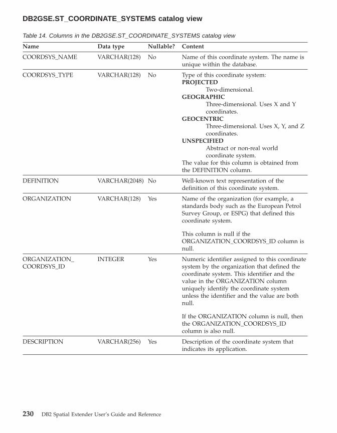
Table 14. Columns in the DB2GSE.ST_COORDINATE_SYSTEMS catalog view
Name Data type Nullable? Content
COORDSYS_NAME VARCHAR(128) No Name of this coordinate system. The name isunique within the database.
COORDSYS_TYPE VARCHAR(128) No Type of this coordinate system:PROJECTED
Two-dimensional.GEOGRAPHIC
Three-dimensional. Uses X and Ycoordinates.
GEOCENTRICThree-dimensional. Uses X, Y, and Zcoordinates.
UNSPECIFIEDAbstract or non-real worldcoordinate system.
The value for this column is obtained fromthe DEFINITION column.
DEFINITION VARCHAR(2048) No Well-known text representation of thedefinition of this coordinate system.
ORGANIZATION VARCHAR(128) Yes Name of the organization (for example, astandards body such as the European PetrolSurvey Group, or ESPG) that defined thiscoordinate system.
This column is null if theORGANIZATION_COORDSYS_ID column isnull.
ORGANIZATION_COORDSYS_ID
INTEGER Yes Numeric identifier assigned to this coordinatesystem by the organization that defined thecoordinate system. This identifier and thevalue in the ORGANIZATION columnuniquely identify the coordinate systemunless the identifier and the value are bothnull.
If the ORGANIZATION column is null, thenthe ORGANIZATION_COORDSYS_IDcolumn is also null.
DESCRIPTION VARCHAR(256) Yes Description of the coordinate system thatindicates its application.
DB2GSE.ST_COORDINATE_SYSTEMS catalog view
230 DB2 Spatial Extender User’s Guide and Reference

The DB2GSE.ST_GEOMETRY_COLUMNS catalog view
Use the DB2GSE.ST_GEOMETRY_COLUMNS catalog view to findinformation about all spatial columns in all tables that contain spatial data inthe database. If a spatial column was registered in association with a spatialreference system, you can also use the view to find out the spatial referencesystem’s name and numeric identifier. For additional information aboutspatial columns, query DB2’s SYSCAT.COLUMN catalog view.
For a description of DB2GSE.ST_GEOMETRY_COLUMNS, see the followingtable.
Table 15. Columns in the DB2GSE.ST_GEOMETRY_COLUMNS catalog view
Name Data type Nullable? Content
TABLE_SCHEMA VARCHAR(128) No Name of the schema to which the table thatcontains this spatial column belongs.
TABLE_NAME VARCHAR(128) No Unqualified name of the table that containsthis spatial column.
COLUMN_NAME VARCHAR(128) No Name of this spatial column.
The combination of TABLE_SCHEMA,TABLE_NAME, and COLUMN_NAMEuniquely identifies the column.
TYPE_SCHEMA VARCHAR(128) No Name of the schema to which the declareddata type of this spatial column belongs. Thisname is obtained from the DB2 catalog.
TYPE_NAME VARCHAR(128) No Unqualified name of the declared data type ofthis spatial column. This name is obtainedfrom the DB2 catalog.
SRS_NAME VARCHAR(128) Yes Name of the spatial reference system that isassociated with this spatial column. If nospatial reference system is associated with thecolumn, then SRS_NAME is null.
SRS_ID INTEGER Yes Numeric identifier of the spatial referencesystem that is associated with this spatialcolumn. If no spatial reference system isassociated with the column, then SRS_ID isnull.
DB2GSE.ST_GEOMETRY_COLUMNS catalog view
Chapter 17. Catalog views 231

The DB2GSE.ST_GEOCODER_PARAMETERS catalog view
When you enable a database for spatial operations, information about theparameters of the supplied geocoder, DB2GSE_USA_GEOCODER, isautomatically recorded in the DB2 Spatial Extender catalog. If you registeradditional geocoders, information about their parameters is also recorded inthe catalog. To retrieve information about a geocoders’ parameters from thecatalog, query the DB2GSE.ST_GEOCODER_PARAMETERS catalog view. Fora description of columns in this view, see the following table.
For more information about geocoders’ parameters, query DB2’sSYSCAT.ROUTINEPARMS catalog view. For a description of this view, see theSQL Reference.
Table 16. Columns in the DB2GSE.ST_GEOCODER_PARAMETERS
Name Data type Nullable? Content
GEOCODER_NAME VARCHAR(128) No Name of the geocoder to which thisparameter belongs.
ORDINAL SMALLINT No Position of this parameter (that is, theparameter specified in thePARAMETER_NAME column) in thesignature of the function that serves as thegeocoder specified in theGEOCODER_NAME column.
The combined values in theGEOCODER_NAME and ORDINAL columnsuniquely identify this parameter.
A record in DB2’s SYSCAT.ROUTINEPARMScatalog view also contains information aboutthis parameter. This record contains a valuethat appears in the ORDINAL column ofSYSCAT.ROUTINEPARMS. This value is thesame one that appears in the ORDINALcolumn of theDB2GSE.ST_GEOCODER_PARAMETERSview.
PARAMETER_NAME VARCHAR(128) Yes Name of this parameter. If a name was notspecified when the function to which thisparameter belongs was created, thePARAMETER_NAME column is null.
The content of the PARAMETER_NAMEcolumn is obtained from the DB2 catalog.
DB2GSE.ST_GEOCODER_PARAMETERS catalog view
232 DB2 Spatial Extender User’s Guide and Reference

Table 16. Columns in the DB2GSE.ST_GEOCODER_PARAMETERS (continued)
Name Data type Nullable? Content
TYPE_SCHEMA VARCHAR(128) No Name of the schema to which this parameterbelongs. This name is obtained from the DB2catalog.
TYPE_NAME VARCHAR(128) No Unqualified name of the data type of thevalues assigned to this parameter. This nameis obtained from the DB2 catalog.
PARAMETER_DEFAULT VARCHAR(2048) Yes The default value that is to be assigned tothis parameter. DB2 will interpret this valueas an SQL expression. If the value is enclosedin quotation marks, it will be passed to thegeocoder as a string. Otherwise, theevaluation of the SQL expression willdetermine what parameter’s data type will bewhen it is passed to the geocoder. If thePARAMETER_DEFAULT column contains anull, then this null value will be passed to thegeocoder.
The default value can have a correspondingvalue in theDB2GSE.ST_GEOCODING_PARAMETERScatalog view. It can also have a correspondingvalue in the input to the ST_run_geocodingstored procedure. If either correspondingvalue differs from the default value, thecorresponding value will override the defaultvalue.
DESCRIPTION VARCHAR(256) Yes Description of the parameter indicating itsapplication.
The DB2GSE.ST_GEOCODERS catalog view
When you enable a database for spatial operations, the supplied geocoder,DB2GSE_USA_GEOCODER, is automatically registered in the DB2 SpatialExtender catalog. When you want to make additional geocoders available tousers, you need to register these geocoders. To retrieve information aboutregistered geocoders, query the DB2GSE.ST_GEOCODERS catalog view. For adescription of columns in this view, see the following table.
For information about geocoders’ parameters, query DB2 Spatial Extender’sDB2GSE.ST_GEOCODER_PARAMETERS catalog view and DB2’sSYSCAT.ROUTINEPARMS catalog view. For information about functions thatare used as geocoders, query DB2’s SYSCAT.ROUTINES catalog view.
DB2GSE.ST_GEOCODER_PARAMETERS catalog view
Chapter 17. Catalog views 233
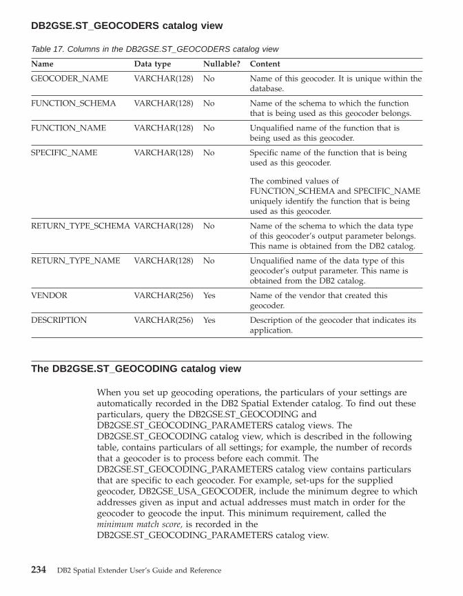
Table 17. Columns in the DB2GSE.ST_GEOCODERS catalog view
Name Data type Nullable? Content
GEOCODER_NAME VARCHAR(128) No Name of this geocoder. It is unique within thedatabase.
FUNCTION_SCHEMA VARCHAR(128) No Name of the schema to which the functionthat is being used as this geocoder belongs.
FUNCTION_NAME VARCHAR(128) No Unqualified name of the function that isbeing used as this geocoder.
SPECIFIC_NAME VARCHAR(128) No Specific name of the function that is beingused as this geocoder.
The combined values ofFUNCTION_SCHEMA and SPECIFIC_NAMEuniquely identify the function that is beingused as this geocoder.
RETURN_TYPE_SCHEMA VARCHAR(128) No Name of the schema to which the data typeof this geocoder’s output parameter belongs.This name is obtained from the DB2 catalog.
RETURN_TYPE_NAME VARCHAR(128) No Unqualified name of the data type of thisgeocoder’s output parameter. This name isobtained from the DB2 catalog.
VENDOR VARCHAR(256) Yes Name of the vendor that created thisgeocoder.
DESCRIPTION VARCHAR(256) Yes Description of the geocoder that indicates itsapplication.
The DB2GSE.ST_GEOCODING catalog view
When you set up geocoding operations, the particulars of your settings areautomatically recorded in the DB2 Spatial Extender catalog. To find out theseparticulars, query the DB2GSE.ST_GEOCODING andDB2GSE.ST_GEOCODING_PARAMETERS catalog views. TheDB2GSE.ST_GEOCODING catalog view, which is described in the followingtable, contains particulars of all settings; for example, the number of recordsthat a geocoder is to process before each commit. TheDB2GSE.ST_GEOCODING_PARAMETERS catalog view contains particularsthat are specific to each geocoder. For example, set-ups for the suppliedgeocoder, DB2GSE_USA_GEOCODER, include the minimum degree to whichaddresses given as input and actual addresses must match in order for thegeocoder to geocode the input. This minimum requirement, called theminimum match score, is recorded in theDB2GSE.ST_GEOCODING_PARAMETERS catalog view.
DB2GSE.ST_GEOCODERS catalog view
234 DB2 Spatial Extender User’s Guide and Reference
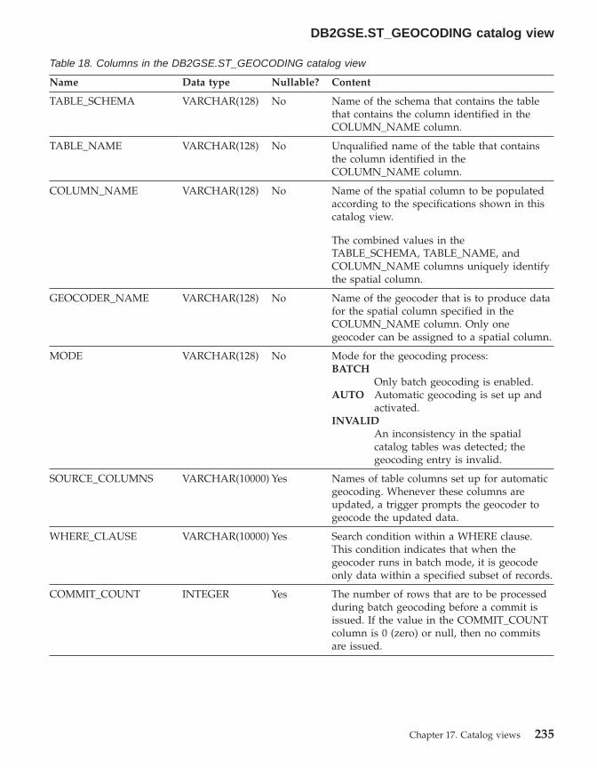
Table 18. Columns in the DB2GSE.ST_GEOCODING catalog view
Name Data type Nullable? Content
TABLE_SCHEMA VARCHAR(128) No Name of the schema that contains the tablethat contains the column identified in theCOLUMN_NAME column.
TABLE_NAME VARCHAR(128) No Unqualified name of the table that containsthe column identified in theCOLUMN_NAME column.
COLUMN_NAME VARCHAR(128) No Name of the spatial column to be populatedaccording to the specifications shown in thiscatalog view.
The combined values in theTABLE_SCHEMA, TABLE_NAME, andCOLUMN_NAME columns uniquely identifythe spatial column.
GEOCODER_NAME VARCHAR(128) No Name of the geocoder that is to produce datafor the spatial column specified in theCOLUMN_NAME column. Only onegeocoder can be assigned to a spatial column.
MODE VARCHAR(128) No Mode for the geocoding process:BATCH
Only batch geocoding is enabled.AUTO Automatic geocoding is set up and
activated.INVALID
An inconsistency in the spatialcatalog tables was detected; thegeocoding entry is invalid.
SOURCE_COLUMNS VARCHAR(10000) Yes Names of table columns set up for automaticgeocoding. Whenever these columns areupdated, a trigger prompts the geocoder togeocode the updated data.
WHERE_CLAUSE VARCHAR(10000) Yes Search condition within a WHERE clause.This condition indicates that when thegeocoder runs in batch mode, it is geocodeonly data within a specified subset of records.
COMMIT_COUNT INTEGER Yes The number of rows that are to be processedduring batch geocoding before a commit isissued. If the value in the COMMIT_COUNTcolumn is 0 (zero) or null, then no commitsare issued.
DB2GSE.ST_GEOCODING catalog view
Chapter 17. Catalog views 235

The DB2GSE.ST_GEOCODING_PARAMETERS catalog view
When you set up geocoding operations for a particular geocoder,geocoder-specific aspects of the settings are automatically recorded in theSpatial Extender catalog. For example, an operation specific to the suppliedgeocoder, DB2GSE_USA_GEOCODER, is to compare addresses given as inputto reference data, and to geocode the former if they match the latter to aspecified degree, or to a degree higher than the specified one. When you setup operations for this geocoder, you specify what this degree, called theminimum match score, should be; and your specification is recorded in thecatalog.
To find out the geocoder-specific aspects of a settings for geocodingoperations, query the DB2GSE.ST_GEOCODING_PARAMETERS catalog view.This view is described in the following table.
Certain defaults for set-ups of geocoding operations are available in theDB2GSE.ST_GEOCODER_PARAMETERS catalog view. Values in theDB2GSE.ST_GEOCODING_PARAMETERS view override the defaults.
Table 19. Columns in the DB2GSE.ST_GEOCODING_PARAMETERS catalog view
Name Data type Nullable? Content
TABLE_SCHEMA VARCHAR(128) No Name of the schema that contains the tablethat contains the column identified in theCOLUMN_NAME column.
TABLE_NAME VARCHAR(128) No Unqualified name of the table that containsthe spatial column.
COLUMN_NAME VARCHAR(128) No Name of the spatial column to be populatedaccording to the specifications shown in thiscatalog view.
The combined values in theTABLE_SCHEMA, TABLE_NAME, andCOLUMN_NAME columns uniquely identifythis spatial column.
DB2GSE.ST_GEOCODING_PARAMETERS catalog view
236 DB2 Spatial Extender User’s Guide and Reference

Table 19. Columns in the DB2GSE.ST_GEOCODING_PARAMETERS catalog view (continued)
Name Data type Nullable? Content
ORDINAL SMALLINT No Position of this parameter (that is, theparameter specified in thePARAMETER_NAME column) in thesignature of the function that serves as thegeocoder for the column identified in theCOLUMN_NAME column.
A record in DB2’s SYSCAT.ROUTINEPARMScatalog view also contains information aboutthis parameter. This record contains a valuethat appears in the ORDINAL column ofSYSCAT.ROUTINEPARMS. This value is thesame one that appears in the ORDINALcolumn of theDB2GSE.ST_GEOCODING_PARAMETERSview.
PARAMETER_NAME VARCHAR(128) Yes Name of a parameter in the definition of thegeocoder. If no name was specified when thegeocoder was defined, PARAMETER_NAMEis null.
This content of the PARAMETER_NAMEcolumn is obtained from the DB2 catalog.
PARAMETER_VALUE VARCHAR(2048) Yes The value that is assigned to this parameter.DB2 will interpret this value as an SQLexpression. If the value is enclosed inquotation marks, it will be passed to thegeocoder as a string. Otherwise, theevaluation of the SQL expression willdetermine what the parameter’s data typewill be when it is passed to the geocoder. Ifthe PARAMETER_VALUE column contains anull, then this null is passed to the geocoder.
The PARAMETER_VALUE columncorresponds to the PARAMETER_DEFAULTcolumn in theDB2GSE.ST_GEOCODER_PARAMETERScatalog view. If the PARAMETER_VALUEcolumn contains a value, this value overridesthe default value in thePARAMETER_DEFAULT column. If thePARAMETER_VALUE column is null, thedefault value will be used.
DB2GSE.ST_GEOCODING_PARAMETERS catalog view
Chapter 17. Catalog views 237

The DB2GSE.ST_SIZINGS catalog view
Use the DB2GSE.ST_SIZINGS catalog view to retrieve:v All the variables supported by Spatial Extender; for example, coordinate
system name, geocoder name, and variables to which well-known textrepresentations of spatial data can be assigned.
v The allowable maximum length, if known, of values assigned to thesevariables (for example, the maximum allowable lengths of names ofcoordinate systems, of names of geocoders, and of well-known textrepresentations of spatial data).
For a description of columns in the view, see the following table.
Table 20. Columns in the DB2GSE.ST_SIZINGS catalog view
Name Data type Nullable? Content
VARIABLE_NAME VARCHAR(128) No Term that denotes a variable. The term isunique within the database.
SUPPORTED_VALUE INTEGER Yes Allowable maximum length of the valuesassigned to the variable shown in theVARIABLE_NAME column. Possible values inthe SUPPORTED_VALUE column are:
A numeric value other than 0The allowable maximum length ofvalues assigned to this variable.
0 Either any length is allowed, or theallowable length cannot bedetermined.
NULL Spatial Extender does not supportthis variable.
DESCRIPTION VARCHAR(128) Yes Description of this variable.
The DB2GSE.ST_SPATIAL_REFERENCE_SYSTEMS catalog view
When you enable a database for spatial operations, two default spatialreference systems—one to use when you do not specify what coordinatesystem your spatial data should derive from, and one to use with theGCS_NORTH_AMERICAN_1983 coordinate system—are automaticallyregistered in the Spatial Extender catalog. When users create additional spatialreference systems, these systems are also automatically registered in thecatalog. To retrieve information about registered spatial reference systems,query the DB2GSE.ST_SPATIAL_REFERENCE_SYSTEMS catalog view.
DB2GSE.ST_SIZINGS catalog view
238 DB2 Spatial Extender User’s Guide and Reference
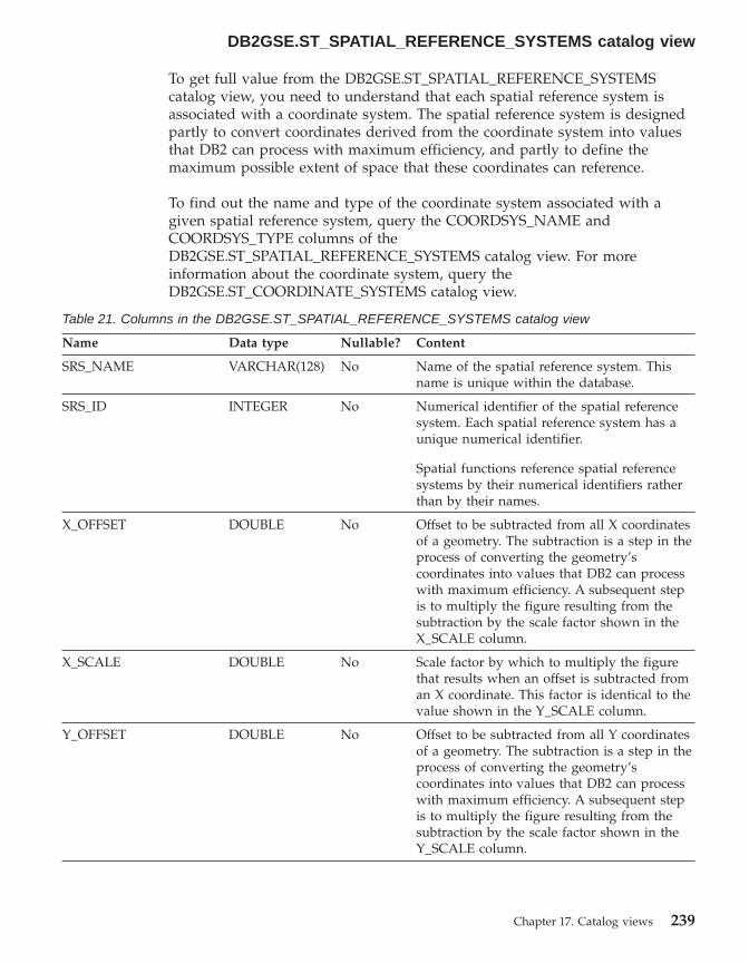
To get full value from the DB2GSE.ST_SPATIAL_REFERENCE_SYSTEMScatalog view, you need to understand that each spatial reference system isassociated with a coordinate system. The spatial reference system is designedpartly to convert coordinates derived from the coordinate system into valuesthat DB2 can process with maximum efficiency, and partly to define themaximum possible extent of space that these coordinates can reference.
To find out the name and type of the coordinate system associated with agiven spatial reference system, query the COORDSYS_NAME andCOORDSYS_TYPE columns of theDB2GSE.ST_SPATIAL_REFERENCE_SYSTEMS catalog view. For moreinformation about the coordinate system, query theDB2GSE.ST_COORDINATE_SYSTEMS catalog view.
Table 21. Columns in the DB2GSE.ST_SPATIAL_REFERENCE_SYSTEMS catalog view
Name Data type Nullable? Content
SRS_NAME VARCHAR(128) No Name of the spatial reference system. Thisname is unique within the database.
SRS_ID INTEGER No Numerical identifier of the spatial referencesystem. Each spatial reference system has aunique numerical identifier.
Spatial functions reference spatial referencesystems by their numerical identifiers ratherthan by their names.
X_OFFSET DOUBLE No Offset to be subtracted from all X coordinatesof a geometry. The subtraction is a step in theprocess of converting the geometry’scoordinates into values that DB2 can processwith maximum efficiency. A subsequent stepis to multiply the figure resulting from thesubtraction by the scale factor shown in theX_SCALE column.
X_SCALE DOUBLE No Scale factor by which to multiply the figurethat results when an offset is subtracted froman X coordinate. This factor is identical to thevalue shown in the Y_SCALE column.
Y_OFFSET DOUBLE No Offset to be subtracted from all Y coordinatesof a geometry. The subtraction is a step in theprocess of converting the geometry’scoordinates into values that DB2 can processwith maximum efficiency. A subsequent stepis to multiply the figure resulting from thesubtraction by the scale factor shown in theY_SCALE column.
DB2GSE.ST_SPATIAL_REFERENCE_SYSTEMS catalog view
Chapter 17. Catalog views 239
Table 21. Columns in the DB2GSE.ST_SPATIAL_REFERENCE_SYSTEMS catalog view (continued)
Name Data type Nullable? Content
Y_SCALE DOUBLE No Scale factor by which to multiply the figurethat results when an offset is subtracted froma Y coordinate. This factor is identical to thevalue shown in the X_SCALE column.
Z_OFFSET DOUBLE No Offset to be subtracted from all Z coordinatesof a geometry. The subtraction is a step in theprocess of converting the geometry’scoordinates into values that DB2 can processwith maximum efficiency. A subsequent stepis to multiply the figure resulting from thesubtraction by the scale factor shown in theZ_SCALE column.
Z_SCALE DOUBLE No Scale factor by which to multiply the figurethat results when an offset is subtracted froma Z coordinate.
M_OFFSET DOUBLE No Offset to be subtracted from all measuresassociated with a geometry. The subtraction isa step in the process of converting themeasures into values that DB2 can processwith maximum efficiency. A subsequent stepis to multiply the figure resulting from thesubtraction by the scale factor shown in theM_SCALE column.
M_SCALE DOUBLE No Scale factor by which to multiply the figurethat results when an offset is subtracted froma measure.
MIN_X DOUBLE No Minimum possible value for X coordinates inthe geometries to which this spatial referencesystem applies. This value is derived from thevalues in the X_OFFSET and X_SCALEcolumns.
MAX_X DOUBLE No Maximum possible value for X coordinates inthe geometries to which this spatial referencesystem applies. This value is derived from thevalues in the X_OFFSET and X_SCALEcolumns.
MIN_Y DOUBLE No Minimum possible value for Y coordinates inthe geometries to which this spatial referencesystem applies. This value is derived from thevalues in the Y_OFFSET and Y_SCALEcolumns.
DB2GSE.ST_SPATIAL_REFERENCE_SYSTEMS catalog view
240 DB2 Spatial Extender User’s Guide and Reference

Table 21. Columns in the DB2GSE.ST_SPATIAL_REFERENCE_SYSTEMS catalog view (continued)
Name Data type Nullable? Content
MAX_Y DOUBLE No Maximum possible value for Y coordinates inthe geometries to which this spatial referencesystem applies. This value is derived from thevalues in the Y_OFFSET and Y_SCALEcolumns.
MIN_Z DOUBLE No Minimum possible value for Z coordinates ingeometries to which this spatial referencesystem applies This value is derived from thevalues in the Z_OFFSET and Z_SCALEcolumns.
MAX_Z DOUBLE No Maximum possible value for Z coordinates ingeometries to which this spatial referencesystem applies. This value is derived from thevalues in the Z_OFFSET and Z_SCALEcolumns.
MIN_M DOUBLE No Minimum possible value for measures thatcan be stored with geometries to which thisspatial reference system applies. This value isderived from the values in the M_OFFSETand M_SCALE columns.
MAX_M DOUBLE No Maximum possible value for measures thatcan be stored with geometries to which thisspatial reference system applies. This value isderived from the values in the M_OFFSETand M_SCALE columns.
COORDSYS_NAME VARCHAR(128) No Identifying name of the coordinate system onwhich this spatial reference system is based.
COORDSYS_TYPE VARCHAR(128) No Type of the coordinate system on which thisspatial reference system is based.
ORGANIZATION VARCHAR(128) Yes Name of the organization (for example, astandards body) that defined the coordinatesystem on which this spatial reference systemis based. ORGANIZATION is null ifORGANIZATION_COORSYS_ID is null.
ORGANIZATION_COORDSYS_ID
INTEGER Yes Name of the organization (for example, astandards body) that defined the coordinatesystem on which this spatial reference systemis based. ORGANIZATION_COORDSYS_ID isnull if ORGANIZATION is null.
DEFINITION VARCHAR(2048) No Well-known text representation of thedefinition of the coordinate system.
DESCRIPTION VARCHAR(256) Yes Description of the spatial reference system.
DB2GSE.ST_SPATIAL_REFERENCE_SYSTEMS catalog view
Chapter 17. Catalog views 241
The DB2GSE.ST_UNITS_OF_MEASURE catalog view
Certain spatial functions accept or return values that denote a specificdistance. In some cases, you can choose what unit of measure the distance isto be expressed in. For example, ST_Distance returns the minimum distancebetween two specified geometries. On one occasion you might requireST_Distance to return the distance in terms of miles; on another, you mightrequire a distance expressed in terms of meters. To find out what units ofmeasure you can choose from, consult the DB2GSE.ST_UNITS_OF_MEASUREcatalog view.
Table 22. Columns in the DB2GSE.ST_UNITS_OF_MEASURE catalog view
Name Data type Nullable? Content
UNIT_NAME VARCHAR(128) No Name of the unit of measure. This name isunique in the database.
UNIT_TYPE VARCHAR(128) No Type of the unit of measure. Possible valuesare:
LINEARThe unit of measure is linear.
ANGULARThe unit of measure is angular.
CONVERSION_FACTOR DOUBLE No Numeric value used to convert this unit ofmeasure to its base unit. The base unit forlinear units of measure is METER; the baseunit for angular units of measure is RADIAN.
The base unit itself has a conversion factor of1.0.
DESCRIPTION VARCHAR(256) Yes Description of the unit of measure.
DB2GSE.ST_UNITS_OF_MEASURE catalog view
242 DB2 Spatial Extender User’s Guide and Reference
Chapter 18. Spatial functions: categories and uses
This chapter introduces all the spatial functions, organizing them by category:v Functions that convert geometries to and from data exchange formatsv Functions that make comparisonsv Functions that return information about properties of geometriesv Functions that derive new geometries from existing onesv Miscellaneous functions
Spatial functions that convert geometries to and from data exchange formats
DB2 Spatial Extender provides spatial functions that convert geometries toand from the following data exchange formats:v Well-known text (WKT) representationv Well-known binary (WKB) representationv ESRI shape representationv Geography Markup Language (GML) representation
The functions for creating geometries from these formats are known asconstructor functions. The next section describes these functions in general.Each successive section focuses on the constructor functions for one of thedata exchange formats.
Constructor functions in generalConstructor functions have the same name as the geometry data type of thecolumn into which the data will be inserted. These functions operateconsistently on each of the input data exchange formats. This sectionprovides:v The SQL for calling functions that operate on data exchange formats, and
the type of geometry returned by these functionsv The SQL for calling a function that creates points from X and Y. coordinates,
and the type of geometry returned by this functionv Examples of code and result sets
Functions that operate on data exchange formatsThis section provides the syntax for calling functions that operate on dataexchange formats, describes the functions’ input parameters, and identifies thetype of geometry that these functions return.
© Copyright IBM Corp. 1998 - 2002 243

Syntax:
�� geometry_typedb2gse.
( wktwkbshapegml
, srs_id) ��
Parameters and other elements of syntax:
db2gse Name of the schema to which the spatial data types supplied by DB2Spatial Extender belong.
geometry_typeOne of the following constructor functions:v ST_Pointv ST_LineStringv ST_Polygonv ST_MultiPointv ST_MultiLineStringv ST_MultiPolygonv ST_GeomCollectionv ST_Geometry
wkt A value of type CLOB(2G) that contains the well-known textrepresentation of the geometry.
wkb A value of type BLOB(2G) that contains the well-known binaryrepresentation of the geometry.
shape A value of type BLOB(2G) that contains the ESRI shape representationof the geometry.
gml A value of type CLOB(2G) that contains the Geography MarkupLanguage (GML) representation of the geometry.
srs_id A value of type INTEGER that identifies the spatial reference systemfor the resulting geometry.
If the srs_id parameter is omitted, then the spatial reference systemwith the numeric identifier 0 (zero) is used.
Return Type:
geometry_type
If geometry_type is ST_Geometry, the dynamic type of the returned geometrytype corresponds to the geometry indicated by the input value.
Spatial functions
244 DB2 Spatial Extender User’s Guide and Reference

If geometry_type is any other type, the dynamic type of the returned geometrytype corresponds to the function name. If the geometry indicated by the inputvalue does not match the function name or the name of one of its subtypes,an error is returned.
A function that creates geometries from coordinatesThe ST_Point function creates geometries not only from data exchangeformats but also from numeric coordinate values—a very useful capability ifyour location data is already stored in your database. This section providesthe syntax for calling ST_Point, an explanation of its parameters, andinformation about the type of geometry that it returns.
Syntax:
�� db2gse.ST_Point ( coordinates, srs_id
) ��
coordinates:
x_coordinate , y_coordinate, z_coordinate
, m_coordinate
Parameters:
x_coordinateA value of type DOUBLE that specifies the X coordinate for theresulting point.
y_coordinateA value of type DOUBLE that specifies the Y coordinate for theresulting point.
z_coordinateA value of type DOUBLE that specifies the Z coordinate for theresulting point.
If the z_coordinate parameter is omitted, the resulting point will nothave a Z coordinate. The result of ST_Is3D is 0 (zero) for such a point.
m_coordinateA value of type DOUBLE that specifies the M coordinate for theresulting point.
If the m_coordinate parameter is omitted, the resulting point will nothave a measure. The result of ST_IsMeasured is 0 (zero) for such apoint.
srs_id A value of type INTEGER that identifies the spatial reference systemfor the resulting point.
Spatial functions
Chapter 18. Spatial functions: categories and uses 245
If the srs_id parameter is omitted, the spatial reference system withthe numeric identifier 0 (zero) is used.
If srs_id does not identify a spatial reference system listed in thecatalog view DB2GSE.ST_SPATIAL_REFERENCE_SYSTEMS, then anexception condition is raised (SQLSTATE 38SU1).
Return type:
db2gse.ST_Point
ExamplesThis section provides examples of code for invoking constructors, code forcreating tables to contain constructors’ output, code for retrieving the output,and the output itself.
The following example will insert a row into the SAMPLE_GEOMETRY tablewith id 100 and a point value with an X coordinate of 30, a Y coordinate of 40and in spatial reference system 1 using the coordinate representation using theWKT representation. It then inserts another row with id 200 and a linestringvalue with the coordinates indicated.
CREATE TABLE sample_geometry (id INT, geom db2gse.ST_Geometry);
INSERT INTO sample_geometry(id, geom)VALUES(100,db2gse.ST_Geometry(’point(30 40)’, 1));
INSERT INTO sample_geometry(id, geom)VALUES(200,db2gse.ST_Geometry(’linestring(50 50, 100 100’, 1));
SELECT id, TYPE_NAME(geom) FROM sample_geometry
ID 2------ --------------------------------
100 "ST_POINT"200 "ST_LINESTRING"
If we know the spatial column may only contain ST_Point values, we coulduse the following example which inserts two points. Attempting to insert alinestring or any other type which is not a point would result in an SQL error.The first insert creates a point geometry from the well-known-textrepresentation (WKT). The second insert creates a point geometry fromnumeric coordinate values. Note that these input values could also be selectedfrom existing table columns.CREATE TABLE sample_points (id INT, geom db2gse.ST_Point);
INSERT INTO sample_points(id, geom)VALUES(100,db2gse.ST_Point(’point(30 40)’, 1));
INSERT INTO sample_points(id, geom)
Spatial functions
246 DB2 Spatial Extender User’s Guide and Reference

VALUES(101,db2gse.ST_Point(50, 50, 1));
SELECT id, TYPE_NAME(geom) FROM sample_geometry
ID 2------ --------------------------------
100 "ST_POINT"101 "ST_POINT"
Most often, data will be inserted by an application program reading from afile or web interface.
The following example uses embedded SQL and assumes that the applicationfills the data areas with the appropriate values. For a reference to furtherdetails on the use of embedded SQL, see Related reference at the end of thissection.EXEC SQL BEGIN DECLARE SECTION;
sqlint32 id = 0;SQL TYPE IS CLOB(10000) wkt_buffer;SQL TYPE IS CLOB(10000) gml_buffer;SQL TYPE IS BLOB(10000) wkb_buffer;SQL TYPE IS BLOB(10000) shape_buffer;
EXEC SQL END DECLARE SECTION;
// * Application logic to read into buffers goes here */
EXEC SQL INSERT INTO sample_geometry(id, geom)VALUES(:id, db2gse.ST_Geometry(:wkt_buffer,1));
EXEC SQL INSERT INTO sample_geometry(id, geom)VALUES:id, db2gse.ST_Geometry(:wkb_buffer,1));
EXEC SQL INSERT INTO sample_geometry(id, geom)VALUES(:id, db2gse.ST_Geometry(:gml_buffer,1));
EXEC SQL INSERT INTO sample_geometry(id, geom)VALUES(:id, db2gse.ST_Geometry(:shape_buffer,1));
The following example Java code uses JDBC to insert point geometries usingX, Y numeric coordinate values and using WKT to specify the geometries. Fora reference to further details on using the JDBC interface, see Relatedreference at the end of this section.String ins1 = "INSERT into sample_geometry (id, geom)
VALUES(?, db2gse.ST_PointFromText(CAST( ?as VARCHAR(128)), 1))";
PreparedStatement pstmt = con.prepareStatement(ins1);pstmt.setInt(1, 100); // id valuepstmt.setString(2, "point(32.4 50.7)"); // wkt valueint rc = pstmt.executeUpdate();
String ins2 = "INSERT into sample_geometry (id, geom)VALUES(?, db2gse.ST_Point(CAST( ? as double),
Spatial functions
Chapter 18. Spatial functions: categories and uses 247

CAST(? as double), 1))";pstmt = con.prepareStatement(ins2);pstmt.setInt(1, 200); // id valuepstmt.setDouble(2, 40.3); // latpstmt.setDouble(3, -72.5); // longrc = pstmt.executeUpdate();
Well-known text (WKT) representationText representations are CLOB values representing character ASCII strings.They permit geometries to be exchanged in ASCII text form.
The function ST_AsText is provided to convert a geometry value stored in atable to a WKT string. The following example uses a simple command linequery to select the values that were previously inserted into theSAMPLE_GEOMETRY table.SELECT id, VARCHAR(db2gse.ST_AsText(geom), 50) AS WKTGEOMFROM sample_geometry;
ID WKTGEOM------ --------------------------------
100 POINT ( 30.00000000 40.00000000)200 LINESTRING ( 50.00000000 50.00000000, 100.00000000 100.00000000)
The following example uses embedded SQL to select the values that werepreviously inserted into the SAMPLE_GEOMETRY table.EXEC SQL BEGIN DECLARE SECTION;sqlint32 id = 0;SQL TYPE IS CLOB(10000) wkt_buffer;short wkt_buffer_ind = -1;EXEC SQL END DECLARE SECTION;
EXEC SQLSELECT id, db2gse.ST_AsText(geom)INTO :id, :wkt_buffer :wkt_buffer_indFROM sample_geometryWHERE id = 100;
Alternatively, the ST_WellKnownText transform group can be used toimplicitly convert geometries to their well-known text representation whenbinding them out. The following example code illustrates how to use thetransform group.EXEC SQL BEGIN DECLARE SECTION;
sqlint32 id = 0;SQL TYPE IS CLOB(10000) wkt_buffer;short wkt_buffer_ind = -1;
EXEC SQL END DECLARE SECTION;
EXEC SQLSET CURRENT DEFAULT TRANSFORM GROUP = ST_WellKnownText;
EXEC SQL
Spatial functions
248 DB2 Spatial Extender User’s Guide and Reference
SELECT id, geomINTO :id, :wkt_buffer :wkt_buffer_indFROM sample_geometryWHERE id = 100;
Note that no spatial function is used in the SELECT statement to convert thegeometry. For a reference to further details on the use of transform groups,see Related reference at the end of this section.
In addition to the functions discussed in this section, DB2 Spatial Extenderprovides other functions that also convert geometries to and from well-knowntext representations. DB2 Spatial Extender provides these other functions toconform to the OGC “Simple Features For SQL” specification and the ISOSQL/MM Part 3: Spatial standard. These other functions are:v ST_WKTToSQL
v ST_GeomFromText
v ST_GeomCollFromTxt
v ST_PointFromText
v ST_LineFromText
v ST_PolyFromText
v ST_MPointFromText
v ST_MLineFromText
v ST_MPolyFromText
Well-known binary (WKB) representationThe WKB representation consists of binary data structures that must be BLOBvalues representing binary data structures that must be managed by anapplication program written in a programming language that DB2 supportsand for which DB2 has a language binding.
The function ST_AsBinary is provided to convert a geometry value stored ina table to the well-known binary WKB representation which can be fetchedinto a BLOB variable in program storage. The following example usesembedded SQL to select the values that were previously inserted into theSAMPLE_GEOMETRY table.EXEC SQL BEGIN DECLARE SECTION;
sqlint32 id = 0;SQL TYPE IS BLOB(10000) wkb_buffer;short wkb_buffer_ind = -1;
EXEC SQL END DECLARE SECTION;
EXEC SQLSELECT id, db2gse.ST_AsBinary(geom)INTO :id, :wkb_buffer :wkb_buffer_indFROM sample_geometryWHERE id = 200;
Spatial functions
Chapter 18. Spatial functions: categories and uses 249

Alternatively, the ST_WellKnownBinary transform group can be used toimplicitly convert geometries to their well-known binary representation whenbinding them out. The following example code illustrates how to use thetransform group.EXEC SQL BEGIN DECLARE SECTION;
sqlint32 id = 0;SQL TYPE IS BLOB(10000) wkb_buffer;short wkb_buffer_ind = -1;
EXEC SQL END DECLARE SECTION;
EXEC SQLSET CURRENT DEFAULT TRANSFORM GROUP = ST_WellKnownBinary;
EXEC SQLSELECT id, geomINTO :id, :wkb_buffer :wkb_buffer_indFROM sample_geometryWHERE id = 200;
Note that no spatial function is used in the SELECT statement to convert thegeometry. For a reference to further details on the use of transform groups,see Related reference at the end of this section.
In addition to the functions discussed in this section, there are other functionsthat also convert geometries to and from well-known binary representations.DB2 Spatial Extender provides these other functions to conform to the OGC“Simple Features For SQL” specification and the ISO SQL/MM Part 3: Spatialstandard. These other functions are:v ST_WKBToSQL
v ST_GeomFromWKB
v ST_GeomCollFromWKB
v ST_PointFromWKB
v ST_LineFromWKB
v ST_PolyFromWKB
v ST_MPointFromWKB
v ST_MLineFromWKB
v ST_MPolyFromWKB
ESRI shape representationThe ESRI Shape representation consists of binary data structures that must bemanaged by an application program written in a supported language.
The function ST_AsShape is provided to convert a geometry value stored in atable to the ESRI Shape representation which can be fetched into a BLOB
Spatial functions
250 DB2 Spatial Extender User’s Guide and Reference

variable in program storage. The following example uses embedded SQL toselect the values that were previously inserted into the SAMPLE_GEOMETRYtable.EXEC SQL BEGIN DECLARE SECTION;
sqlint32 id;SQL TYPE IS BLOB(10000) shape_buffer;
EXEC SQL END DECLARE SECTION;
EXEC SQLSELECT id, db2gse.ST_AsShape(geom)INTO :id, :shape_bufferFROM sample_geometry;
Alternatively, the ST_Shape transform group can be used to implicitly convertgeometries to their shape representation when binding them out. Thefollowing example code illustrates how to use the transform group.EXEC SQL BEGIN DECLARE SECTION;
sqlint32 id = 0;SQL TYPE IS BLOB(10000) shape_buffer;short shape_buffer_ind = -1;
EXEC SQL END DECLARE SECTION;
EXEC SQLSET CURRENT DEFAULT TRANSFORM GROUP = ST_Shape;
EXEC SQLSELECT id, geomFROM sample_geometryWHERE id = 300;
Note that no spatial function is used in the SELECT statement to convert thegeometry.
Geography Markup Language (GML) representationGML representations are ASCII strings. They permit geometries to beexchanged in ASCII text form.
The function ST_AsGML is provided to convert a geometry value stored in atable to a GML text string. The following example selects the values that werepreviously inserted into the SAMPLE_GEOMETRY table.
The following example code illustrates how to use the transform group. In thefollowing example, the results have been reformatted for readability. Thespacing in your results will vary according to your online display.SELECT id, VARCHAR(db2gse.ST_AsGML(geom), 500) AS GMLGEOMFROM sample_geometry;
ID GMLGEOM----------- ----------------------------------------------------------
100 <gml:Point srsName="EPSG:4269">
Spatial functions
Chapter 18. Spatial functions: categories and uses 251

<gml:coord><gml:X>30</gml:X><gml:Y>40</gml:Y></gml:coord></gml:Point>
200 <gml:LineString srsName="EPSG:4269"><gml:coord><gml:X>50</gml:X><gml:Y>50</gml:Y></gml:coord><gml:coord><gml:X>100</gml:X><gml:Y>100</gml:Y></gml:coord></gml:LineString>
Alternatively, the ST_GML transform group can be used to implicitly convertgeometries to their HTML representation when binding them out.SET CURRENT DEFAULT TRANSFORM GROUP = ST_GML
SELECT id, geom AS GMLGEOMFROM sample_geometry;
ID GMLGEOM----------- ----------------------------------------------------------
100 <gml:Point srsName="EPSG:4269"><gml:coord><gml:X>30</gml:X><gml:Y>40</gml:Y></gml:coord></gml:Point>
200 <gml:LineString srsName="EPSG:4269"><gml:coord><gml:X>50</gml:X><gml:Y>50</gml:Y></gml:coord><gml:coord><gml:X>100</gml:X><gml:Y>100</gml:Y></gml:coord></gml:LineString>
Note that no spatial function is used in the select statement to convert thegeometry.
Related reference:
v “Transform groups” on page 489
Functions that make comparisons
Certain spatial functions return information about ways in which geographicfeatures relate to one another or compare with one another. Other spatialfunctions return information as to whether two definitions of coordinatesystems or two spatial reference systems are the same. In all cases, theinformation returned is a result of a comparison between geometries, betweendefinitions of coordinate systems, or between spatial reference systems. Thissection refers to these functions as comparison functions. It discusses theirgeneral nature, describes them individually, and points out differencesbetween functions that are similar.
Comparison functions in generalDB2 Spatial Extender’s comparison functions return a value of 1 (one) if acomparison meets certain criteria, a value of 0 (zero) if a comparison fails tomeet the criteria, or null if the comparison could not be performed.Comparisons cannot be performed if the comparison operation has not been
Spatial functions
252 DB2 Spatial Extender User’s Guide and Reference

defined for the input parameters, or if either of the parameters is null.Comparisons can be performed if geometries with different data types ordimensions are assigned to the parameters.
The Dimensionally Extended 9 Intersection Model (DE-9IM) is a mathematicalapproach that defines the pair-wise spatial relationship between geometries ofdifferent types and dimensions. This model expresses spatial relationshipsbetween all types of geometries as pair-wise intersections of their interior,boundary and exterior, with consideration for the dimension of the resultingintersections.
Given geometries a and b: I(a), B(a), and E(a) represent the interior, boundary,and exterior of a, respectively. And, I(b), B(b), and E(b) represent the interior,boundary, and exterior of b. The intersections of I(a), B(a), and E(a) with I(b),B(b), and E(b) produces a 3 by 3 matrix. Each intersection can result ingeometries of different dimensions. For example, the intersection of theboundaries of two polygons consists of a point and a linestring, in which casethe dim function would return the maximum dimension of 1.
The dim function returns a value of –1, 0, 1 or 2. The –1 corresponds to thenull set or dim(null), which is returned when no intersection was found.
Interior Boundary ExteriorInterior dim(I(a) � I(b)) dim(I(a) � B(b)) dim(I(a) � E(b))
Boundary dim(B(a) � I(b)) dim(B(a) � B(b)) dim(B(a) � E(b))Exterior dim(E(a) � I(b)) dim(E(a) � B(b)) dim(E(a) � E(b))
Results returned by comparison functions can be understood or verified bycomparing the results returned by a comparison function with a patternmatrix that represents the acceptable values for the DE-9IM.
The pattern matrix contains the acceptable values for each of the intersectionmatrix cells. The possible pattern values are:
T An intersection must exist, dim = 0, 1, or 2.
F An intersection must not exist, dim = -1.
* It does not matter if an intersection exists, dim = -1, 0, 1, or 2.
0 An intersection must exist and its exact dimension must be 0, dim = 0.
1 An intersection must exist and its maximum dimension must be 1,dim = 1.
2 An intersection must exist and its maximum dimension must be 2,dim = 2.
Spatial functions
Chapter 18. Spatial functions: categories and uses 253

For example, the following pattern matrix for the ST_Within function includesthe values T, F, and *.
Table 23. Matrix for ST_Within. The pattern matrix of the ST_Within function forgeometry combinations.
bInterior Boundary Exterior
a Interior T * FBoundary * * F
Exterior * * *
The ST_Within function returns a value of 1 when the interiors of bothgeometries intersect and when the interior or boundary of a does not intersectthe exterior of b. All other conditions do not matter.
Each function has at least one pattern matrix, but some require more than oneto describe the relationships of various geometry type combinations.
The DE-9IM was developed by Clementini and Felice, who dimensionallyextended the 9 Intersection Model of Egenhofer and Herring. DE-9IM iscollaboration of four authors, Clementini, Eliseo, Di Felice, and van Osstrom.They published the model in ″A Small Set of Formal Topological RelationshipsSuitable for End-User Interaction,″ D. Abel and B.C. Ooi (Ed.), Advances inSpatial Database—Third International Symposium. SSD ’93. LNCS 692. Pp.277-295. The 9 Intersection model by M. J. Egenhofer and J. Herring(Springer-Verlag Singapore [1993]) was published in ″Categorizing binarytopological relationships between regions, lines, and points in geographicdatabases,″ Tech. Report, Department of Surveying Engineering, University ofMaine, Orono, ME 1991.
Descriptions of functionsThe comparison functions are:v ST_Containsv ST_Crossesv ST_Disjointv ST_EnvIntersectsv ST_EqualCoordsysv ST_Equalsv ST_EqualSRSv ST_Intersectsv ST_MBRIntersectsv ST_Overlapsv ST_Relate
Spatial functions
254 DB2 Spatial Extender User’s Guide and Reference

v ST_Touchesv ST_Within
ST_ContainsST_Contains returns a value of 1 (one) if the second geometry is completelycontained by the first geometry. The ST_Contains function returns the exactopposite result of the ST_Within function.
The pattern matrix of the ST_Contains function states that the interiors of bothgeometries must intersect and that the interior and boundary of the secondary(geometry b ) must not intersect the exterior of the primary (geometry a ).
Figure 15. ST_Contains. The dark geometries represent geometry a and the gray geometriesrepresent geometry b. In all cases, geometry a contains geometry b completely.
Spatial functions
Chapter 18. Spatial functions: categories and uses 255

Table 24. Matrix for ST_ContainsbInterior Boundary Exterior
a Interior T * *Boundary * * *
Exterior F F *
ST_CrossesST_Crosses takes two geometries and returns a value of 1 (one) if:v The intersection results in a geometry whose dimension is less than the
maximum dimension of the source geometries.v The intersection set is interior to both source geometries.
ST_Crosses returns a null if the first geometry is a surface or multisurface or ifthe second geometry is a point or multipoint. For all other combinations,ST_Crosses returns either a value of 1 (one: yes, the two geometries cross) or avalue of 0 (zero: no, they do not cross).
The pattern matrix in Table 25 on page 257 applies if the first geometry is apoint or multipoint, or if the first geometry is a curve or multicurve, and thesecond geometry is a surface. The matrix states that the interiors mustintersect and that the interior of the primary (geometry a ) must intersect theexterior of the secondary (geometry b ).
multipoint/linestring linestring/linestring
multipoint/polygon linestring/polygon
Figure 16. ST_Crosses. The dark geometries represent geometry a; the gray geometries representgeometry b. In all cases, geometry b crosses geometry a.
Spatial functions
256 DB2 Spatial Extender User’s Guide and Reference

Table 25. Matrix for ST_Crosses (1)bInterior Boundary Exterior
a Interior T * TBoundary * * *
Exterior * * *
The pattern matrix in Table 26 applies if the first and second geometries areboth curves or multicurves. The matrix states that the dimension of theintersection of the interiors must be 0 (intersect at a point). If the dimension ofthis intersection is 1 (intersect at a linestring), the ST_Crosses function returnsa value of 0 (no, the geometries do not cross); however, the ST_Overlapsfunction returns a value of 1 (yes, the geometries overlap).
Table 26. Matrix for ST_Crosses (2)bInterior Boundary Exterior
a Interior 0 * *Boundary * * *
Exterior * * *
ST_DisjointST_Disjoint returns a value of 1 (one) if the intersection of the two geometriesis an empty set. This function returns the exact opposite of what ST_Intersectsreturns.
Spatial functions
Chapter 18. Spatial functions: categories and uses 257

Table 27. Matrix for ST_Disjoint. This matrix simply states that neither the interiors northe boundaries of either geometry intersect.
bInterior Boundary Exterior
a Interior F F *Boundary F F *
Exterior * * *
ST_EnvIntersectsST_Envintersect returns a value of 1 (one) if the envelopes of two geometriesintersect. It is a convenience function that efficiently implements ST_Intersects(ST_Envelope(g1),ST_Envelope(g2)).
Figure 17. ST_Disjoint. The dark geometries represent geometry a; the gray geometries representgeometry b. In all cases, geometry a and geometry b are disjoint from one another.
Spatial functions
258 DB2 Spatial Extender User’s Guide and Reference

ST_EqualCoordsysST_EqualCoordsys returns a value of 1 (one) if two coordinate systemdefinitions are identical. In comparing the definitions, ST_EqualCoordsysdisregards differences in case, spaces, parentheses, and representation offloating point numbers.
ST_EqualsST_Equals returns a value of 1 (one) if two geometries are identical. The orderof the points used to define the geometries is not relevant to the test ofequality.
Figure 18. ST_Equals. The dark geometries represent geometry a; the gray geometries representgeometry b. In all cases, geometry a is equal to geometry b.
Spatial functions
Chapter 18. Spatial functions: categories and uses 259

Table 28. Matrix for equality. The DE-9IM pattern matrix for equality ensures that theinteriors intersect and that no part interior or boundary of either geometry intersects theexterior of the other.
bInterior Boundary Exterior
a Interior T * FBoundary * * F
Exterior F F *
ST_EqualSRSST_EqualSRS returns a value of 1 (one) if two spatial reference systems areidentical, provided that the numeric identifier of either or both systems is notnull.
ST_IntersectsST_Intersects returns a value of 1 (one) if the intersection does not result in anempty set. Intersects returns the exact opposite result of ST_Disjoint.
The ST_Intersects function returns 1 (one) if the conditions of any of thefollowing pattern matrices returns TRUE.
Table 29. Matrix for ST_Intersects (1). The ST_Intersects function returns 1 (one) if theinteriors of both geometries intersect.
bInterior Boundary Exterior
a Interior T * *Boundary * * *
Exterior * * *
Table 30. Matrix for ST_Intersects (2). The ST_Intersects function returns 1 (one) if theboundary of the first geometry intersects the boundary of the second geometry.
bInterior Boundary Exterior
a Interior * T *Boundary * * *
Exterior * * *
Table 31. Matrix for ST_Intersects (3). The ST_Intersects function returns 1 (one) if theboundary of the first geometry intersects the interior of the second.
bInterior Boundary Exterior
a Interior * * *Boundary T * *
Exterior * * *
Spatial functions
260 DB2 Spatial Extender User’s Guide and Reference

Table 32. Matrix for ST_Intersects (4). The ST_Intersects function returns 1 (one) if theboundaries of either geometry intersect.
bInterior Boundary Exterior
a Interior * * *Boundary * T *
Exterior * * *
ST_MBRIntersectsST_MBRIntersects returns a value of 1 (one) if the minimum boundingrectangles (MBRs) of two geometries intersect.
ST_OverlapsST_Overlaps compares two geometries of the same dimension. It returns avalue of 1 (one) if their intersection set results in a geometry different fromboth, but that has the same dimension.
The pattern matrix in Table 33 applies if the first and second geometries areboth either points, multipoints, surfaces, or multisurfaces. ST_Overlaps returnsa value of 1 if the interior of each geometry intersects the other geometry’sinterior and exterior.
Table 33. Matrix for ST_Overlaps (1)bInterior Boundary Exterior
a Interior T * TBoundary * * *
Exterior T * *
The pattern matrix in Table 34 on page 262 applies if the first and secondgeometries are both curves or multicurves. In this case the intersection of the
multipoint/multipoint linestring/linestring polygon/polygon
Figure 19. ST_Overlaps. The dark geometries represent geometry a; the gray geometriesrepresent geometry b. In all cases, both geometries have the same dimension, and one overlapsthe other partway. The area of overlap is a new geometry; it has the same dimension asgeometries a and b.
Spatial functions
Chapter 18. Spatial functions: categories and uses 261

geometries must result in a geometry that has a dimension of 1 (anothercurve). If the dimension of the intersection of the interiors is 1, ST_Overlapsreturns a value of 0 (no, the geometries do not overlap); however theST_Crosses function would return a value of 1 (yes, the geometries cross).
Table 34. Matrix for ST_Overlaps (2)bInterior Boundary Exterior
a Interior 1 * TBoundary * * *
Exterior T * *
ST_RelateThe ST_Relate function compares two geometries and returns a value of 1(one) if the geometries meet the conditions specified by the DE-9IM patternmatrix string; otherwise, the function returns a value of 0 (zero).
ST_TouchesST_Touches returns a value of 1 (one) if all the points common to bothgeometries can be found only on the boundaries. The interiors of thegeometries must not intersect one another. At least one geometry must be acurve, surface, multicurve, or multisurface.
point/linestring multipoint/linestring linestring/linestring
point/polygon multipoint/polygon linestring/polygon
Figure 20. ST_Touches. The dark geometries represent geometry a; the gray geometries representgeometry b. In all cases, the boundary of geometry b intersects geometry a. The interior ofgeometry b remains separate from geometry a.
Spatial functions
262 DB2 Spatial Extender User’s Guide and Reference
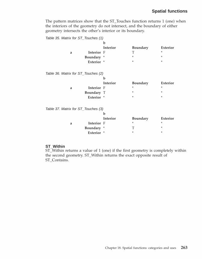
The pattern matrices show that the ST_Touches function returns 1 (one) whenthe interiors of the geometry do not intersect, and the boundary of eithergeometry intersects the other’s interior or its boundary.
Table 35. Matrix for ST_Touches (1)bInterior Boundary Exterior
a Interior F T *Boundary * * *
Exterior * * *
Table 36. Matrix for ST_Touches (2)bInterior Boundary Exterior
a Interior F * *Boundary T * *
Exterior * * *
Table 37. Matrix for ST_Touches (3)bInterior Boundary Exterior
a Interior F * *Boundary * T *
Exterior * * *
ST_WithinST_Within returns a value of 1 (one) if the first geometry is completely withinthe second geometry. ST_Within returns the exact opposite result ofST_Contains.
Spatial functions
Chapter 18. Spatial functions: categories and uses 263

The ST_Within function pattern matrix states that the interiors of bothgeometries must intersect, and that the interior and boundary of the primarygeometry (geometry a ) must not intersect the exterior of the secondary(geometry b ).
Table 38. Matrix for ST_WithinbInterior Boundary Exterior
a Interior T * FBoundary * * F
Exterior * * *
Differences between similar functionsThis section will briefly describe the differences between:v ST_Contains and ST_Within
Figure 21. ST_Within
Spatial functions
264 DB2 Spatial Extender User’s Guide and Reference

v ST_Intersects, ST_Crosses and ST_Overlapsv ST_EnvIntersects and ST_MBRIntersects
ST_Contains and ST_Within both take two geometries as input and determinewhether the interior of one intersects the interior of the other. In colloquialterms, ST_Contains determines whether the first geometry given to it enclosesthe second geometry; in other words, whether the first contains the second.ST_Within determines whether the first geometry is completely inside thesecond; that is, whether the first is within the second.
ST_Intersects, ST_Crosses, ST_Overlaps, and ST_Touches all determinewhether one geometry intersects another. They differ mainly as to the scope ofintersection that they test for:v ST_Intersects tests to determine whether the two geometries given to it
meet one of four conditions: that the geometries’ interiors intersect, thattheir boundaries intersect, that the boundary of the first geometryinterstects with the interior of the second, or that the interior of the firstgeometry intersects with the boundary of the second.
v ST_Crosses is used to analyze the intersection of geometries of differentdimensions, with one exception: it can also analyze the intersection oflinestrings. In all cases, the place of intersection is itself considered ageometry; and ST_Crosses requires that this geometry be of a lesserdimension than the greater of the intersecting geometries (or, if both arelinestrings, that the place of intersection be of a lesser dimension than alinestring). For example, the dimensions of a linestring and polygon are 1and 2, respectively. If two such geometries intersect, and if the place ofintersection is linear (the linestring’s path along the polygon), then thatplace can itself be considered a linestring. And because a linestring’sdimension (1) is lesser than a polygon’s (2), ST_Crosses, after analyzing theintersection, would return a value of 1.
v The geometries given to ST_Overlaps as input must be of the samedimension. ST_Overlaps requires that these geometries overlap partway,forming a new geometry (the region of overlap) that is the same dimensionas they are.
v ST_Touches determines whether the boundaries of two geometries intersect.
ST_EnvIntersects and ST_MBRIntersects are similar in that they determinewhether the smallest rectangle that encloses one geometry intersects with thesmallest rectangle that encloses another geometry. Such a rectangle hastraditionally been called an envelope. Multipolygons, polygons,multilinestrings, and crooked linestrings abut against the sides of theirenvelopes; horizontal linestrings, vertical linestrings, and points are slightlysmaller than their envelopes. ST_EnvIntersects tests to determine whetherenvelopes of geometries intersect.
Spatial functions
Chapter 18. Spatial functions: categories and uses 265

More recently, the smallest rectangular area into which a geometry can fit hasbeen called a minimum bounding rectangle (MBR). The envelopessurrounding multipolygons, polygons, multilinestrings, and crookedlinestrings are actually MBRs. But the envelopes surrounding horizontallinestrings, vertical linestrings, and points are not MBRs, because they do notconstitute a minimum area in which these latter geometries fit. These lattergeometries occupy no definable space and therefore cannot have MBRs.Nevertheless, a convention has been adopted whereby they are referred to astheir own MBRs. Therefore, with respect to multipolygons, polygons,multilinestrings, and crooked linestrings, ST_MBRIntersects tests theintersection of the same surrounding rectangles that ST_EnvIntersects tests.But for horizonal linestrings, vertical linestrings, and points, ST_MBRIntersectstests the intersections of these geometries themselves.
Functions that return information about properties of geometries
This section introduces spatial functions that return information aboutproperties of geometries. This information concerns:v Data types of geometriesv Coordinates and measures within a geometryv Rings, boundaries, envelopes, and minimum bounding rectangles (MBRs)v Dimensionsv The qualities of being closed, empty, or simplev Base geometries within a geometry collectionv Spatial reference systems
Some properties are geometries in their own right; for example, the exteriorand interior rings of a surface, or the start- and endpoints of a curve. Thesegeometries are produced by some of the functions in this category. Functionsthat produce other kinds of geometries—for example, geometries thatrepresent zones that surround a given location—belong to another category.For information about this other category, which is called “Spatial functionsthat generate new geometries”, see the appropriate link or cross-reference atthe end of this section.
ST_GeometryType: A function for information about data typesST_GeometryType takes a geometry as input parameter and returns the fullyqualified type name of the dynamic type of that geometry.
Functions for information about coordinates and measuresThe following functions return information about the coordinates andmeasures within a geometry. For example, ST_X can return the X coordinatewithin a specified point, ST_MaxX returns the highest X coordinate within ageometry, and ST_MinX returns the lowest X coordinate within a geometry.
Spatial functions
266 DB2 Spatial Extender User’s Guide and Reference
These functions are:v ST_CoordDimv ST_IsMeasuredv ST_IsValidv ST_Is3Dv ST_Mv ST_MaxMv ST_MaxXv ST_MaxYv ST_MaxZv ST_MinMv ST_MinXv ST_MinYv ST_MinZv ST_Xv ST_Yv ST_Z
ST_CoordDimST_CoordDim returns a value that denotes what types of coordinates ageometry has, and whether the geometry also contains any measures. Thisvalue is called a coordinate dimension. (Note that a coordinate dimension is notthe same thing as the property referred to as dimension. The latter indicateswhether a geometry has breadth or length, not whether it contains coordinatesof a specific type or measures.
ST_IsMeasuredST_IsMeasured takes a geometry as an input parameter and returns 1 if thegiven geometry has M coordinates (measures). Otherwise 0 (zero) is returned.
ST_IsValidST_IsValid takes a geometry as an input parameter and returns 1 if it is valid.Otherwise 0 (zero) is returned. A geometry is valid only if all of the attributesin the structured type are consistent with the internal representation ofgeometry data, and if the internal representation is not corrupted.
ST_Is3DST_Is3d takes a geometry as an input parameter and returns 1 if the givengeometry has Z coordinates. Otherwise, 0 (zero) is returned.
ST_MIf a measure is stored with a given point, ST_M can take the point as an inputparameter and return the measure.
Spatial functions
Chapter 18. Spatial functions: categories and uses 267

ST_MaxMST_MaxM takes a geometry as an input parameter and returns its maximummeasure.
ST_MaxXST_MaxX takes a geometry as an input parameter and returns its maximum Xcoordinate.
ST_MaxYST_MaxY takes a geometry as an input parameter and returns its maximum Ycoordinate.
ST_MaxZST_MaxZ takes a geometry as an input parameter and returns its minimum Zcoordinate.
ST_MinMST_MinM takes a geometry as an input parameter and returns its minimummeasure.
ST_MinXST_MinX takes a geometry as an input parameter and returns its minimum Xcoordinate.
ST_MinYST_MinZ takes a geometry as an input parameter and returns its minimum Ycoordinate.
ST_MinZST_MinY takes a geometry as an input parameter and returns its minimum Zcoordinate.
ST_XST_X can take point as an input parameter and return the point’s Xcoordinate.
ST_YST_Y can take point as an input parameter and return the point’s Ycoordinate.
ST_ZIf a Z coordinate is stored with a given point, ST_Z can take the point as aninput parameter and return the Z coordinate.
Functions for information about geometries within a geometryThe following functions return information about geometries within ageometry. For example, some functions identify specific points within ageometry; others return the number of base geometries within a collection.
Spatial functions
268 DB2 Spatial Extender User’s Guide and Reference
These functions are:v ST_Centroidv ST_EndPointv ST_GeometryNv ST_LineStringNv ST_MidPointv ST_NumGeometriesv ST_NumLineStringsv ST_NumPointsv ST_NumPolygonsv ST_PointNv ST_PolygonNv ST_StartPoint
ST_CentroidST_Centroid takes a geometry as an input parameter and returns thegeometric center, which is the center of the minimum bounding rectangle ofthe given geometry, as a point.
ST_EndPointST_Endpoint takes a curve as an input parameter and returns the point that isthe last point of the curve.
ST_GeometryNST_GeometryN takes a geometry collection and an index as input parametersand returns the geometry in the collection that is identified by the index.
ST_LineStringNST_LineStringN takes a multilinestring and an index as input parameters andreturns the linestring that is identified by the index.
ST_MidPointST_MidPoint takes a curve as an input parameter and returns the point on thecurve that is equidistant from both end points of the curve, measured alongthe curve.
ST_NumGeometriesST_NumGeometries takes a geometry collection as an input parameter andreturns the number of geometries in the collection.
ST_NumLineStringsST_NumLineStrings takes a multilinestring as an input parameter and returnsthe number of linestrings that it contains.
Spatial functions
Chapter 18. Spatial functions: categories and uses 269

ST_NumPointsST_NumPoints takes a geometry as an input parameter and returns thenumber of points that were used to define that geometry. For example, if thegeometry is a polygon and five points were used to define that polygon, thenthe returned number is 5.
ST_NumPolygonsST_NumPolygons takes a multipolygon as an input parameter and returns thenumber of polygons that it contains.
ST_PointNST_PointN takes a linestring or a multipoint and an index as input parametersand returns that point in the linestring or multipoint that is identified by theindex.
ST_PolygonNST_PolygonN takes a multipolygon and an index as input parameters andreturns the polygon that is identified by the index.
ST_StartPointST_StartPoint takes a curve as an input parameter and returns the point thatis the first point of the curve.
Functions for information about rings, boundaries, envelopes, andminimum bounding rectangles
The following functions return information about demarcations that divide aninner part of a geometry from an outer part, or that divide the geometry itselffrom the space external to it. For example, ST_Boundary returns a geometry’sboundary in the form of a curve.
These functions are:v ST_Boundaryv ST_Envelopev ST_EnvIntersectsv ST_ExteriorRingv ST_InteriorRingNv ST_MBRv ST_MBRIntersectsv ST_NumInteriorRingv ST_Perimeter
ST_BoundaryST_Boundary takes a geometry as an input parameter and returns itsboundary as a new geometry.
Spatial functions
270 DB2 Spatial Extender User’s Guide and Reference

ST_EnvelopeST_Envelope takes a geometry as an input parameter and returns an envelopearound the geometry. The envelope is a rectangle that is represented as apolygon.
ST_EnvIntersectsST_EnvIntersects takes two geometries as input parameters and returns 1 ifthe envelopes of two geometries intersect. Otherwise, 0 (zero) is returned.
ST_ExteriorRingST_ExteriorRing takes a polygon as an input parameter and returns itsexterior ring as a curve.
ST_InteriorRingNST_InteriorRingN takes a polygon and an index as input parameters andreturns the interior ring identified by the given index as a linestring. Theinterior rings are organized according to the rules defined by the internalgeometry verification routines and not by any geometric orientation.
ST_MBRST_MBR takes a geometry as an input parameter and returns its minimumbounding rectangle.
ST_MBRIntersectsST_MBRIntersects returns a value of 1 (one) if the minimum boundingrectangles (MBRs) of two geometries intersect.
ST_NumInteriorRingST_NumInteriorRing takes a polygon as an input parameter and returns thenumber of its interior rings.
ST_PerimeterST_Perimeter takes a surface or multisurface and, optionally, a unit as inputparameters and returns the perimeter of the surface or multisurface, that isthe length of its boundary, measured in the given units.
Functions for information about dimensionsThe following functions return information about the dimension of ageometry. For example, ST_Area reports how much area a given geometrycovers.
These functions are:v ST_Areav ST_Dimensionv ST_Length
Spatial functions
Chapter 18. Spatial functions: categories and uses 271

ST_AreaST_Area takes a geometry and, optionally, a unit as input parameters andreturns the area covered by the given geometry in the given unit of measure.
ST_DimensionST_Dimension takes a geometry as an input parameter and returns itsdimension.
ST_LengthST_Length takes a curve or multicurve and, optionally, a unit as inputparameters and returns the length of the given curve or multicurve in thegiven unit of measure.
Functions for information as to whether a geometry is closed, empty, orsimple
The following functions indicate:v Whether a given curve or multicurve is closed (that is, whether the start
point and end point of the curve or multicurve are the same)v Whether a given geometry is empty (that is, devoid of points)v Whether a curve, multicurve, or multipoint is simple (that is, whether such
geometries have typical configurations)
These functions are:v ST_IsClosedv ST_IsEmptyv ST_IsSimple
ST_IsClosedST_IsClosed takes a curve or multicurve as an input parameter and returns 1if the given curve or multicurve is closed. Otherwise, 0 (zero) is returned.
ST_IsEmptyST_IsEmpty takes a geometry as an input parameter and returns 1 if the givengeometry is empty. Otherwise 0 (zero) is returned.
ST_IsSimpleST_IsSimple takes a geometry as an input parameter and returns 1 if thegiven geometry is simple. Otherwise, 0 (zero) is returned.
Functions for information about spatial reference systemsThe following functions return values that identify the spatial referencesystem that has been associated with the geometry. In addition, the functionST_SrsID can change the geometry’s spatial reference system withoutchanging or transforming the geometry.
These functions are:
Spatial functions
272 DB2 Spatial Extender User’s Guide and Reference

v ST_SrsId (also called ST_SRID)v ST_SrsName
ST_SrsId (also called ST_SRID)ST_SrsId (or ST_SRID) takes a geometry and, optionally, a spatial referencesystem identifier as input parameters. What it returns depends on what inputparameters are specified:v If the spatial reference system identifier is specified, it returns the geometry
with its spatial reference system changed to the specified spatial referencesystem. No transformation of the geometry is performed.
v If no spatial reference system identifier is given as an input parameter, thecurrent spatial reference system identifier of the given geometry is returned.
ST_SrsNameST_SrsName takes a geometry as an input parameter and returns the name ofthe spatial reference system in which the given geometry is represented.
Spatial functions that generate new geometries
This section introduces the category of functions that derive new geometriesfrom existing ones. This category does not include functions that derivegeometries that represent properties of other geometries. Rather, it is forfunctions that:v Convert geometries into other geometriesv Create geometries that represent configurations of spacev Derive individual geometries from multiple geometriesv Create geometries based on measuresv Create modifications of geometries
Functions for converting geometries into other geometriesThe following functions can convert geometries of a super type intocorresponding geometries of a subtype. For example, the ST_ToLineStringfunction can convert a linestring of type ST_Geometry into a linestring ofST_LineString. Some of these functions can also combine base geometries andgeometry collections into a single geometry collection. For example,ST_ToMultiLine can convert a linestring and a multilinestring into a singlemultilinestring.
These functions are:v ST_Polygonv ST_ToGeomCollv ST_ToLineStringv ST_ToMultiLine
Spatial functions
Chapter 18. Spatial functions: categories and uses 273
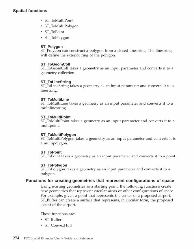
v ST_ToMultiPointv ST_ToMultiPolygonv ST_ToPointv ST_ToPolygon
ST_PolygonST_Polygon can construct a polygon from a closed linestring. The linestringwill define the exterior ring of the polygon.
ST_ToGeomCollST_ToGeomColl takes a geometry as an input parameter and converts it to ageometry collection.
ST_ToLineStringST_ToLineString takes a geometry as an input parameter and converts it to alinestring.
ST_ToMultiLineST_ToMultiLine takes a geometry as an input parameter and converts it to amultilinestring.
ST_ToMultiPointST_ToMultiPoint takes a geometry as an input parameter and converts it to amultipoint.
ST_ToMultiPolygonST_ToMultiPolygon takes a geometry as an input parameter and converts it toa multipolygon.
ST_ToPointST_ToPoint takes a geometry as an input parameter and converts it to a point.
ST_ToPolygonST_ToPolygon takes a geometry as an input parameter and converts it to apolygon.
Functions for creating geometries that represent configurations of spaceUsing existing geometries as a starting point, the following functions createnew geometries that represent circular areas or other configurations of space.For example, given a point that represents the center of a proposed airport,ST_Buffer can create a surface that represents, in circular form, the proposedextent of the airport.
These functions are:v ST_Bufferv ST_ConvexHull
Spatial functions
274 DB2 Spatial Extender User’s Guide and Reference
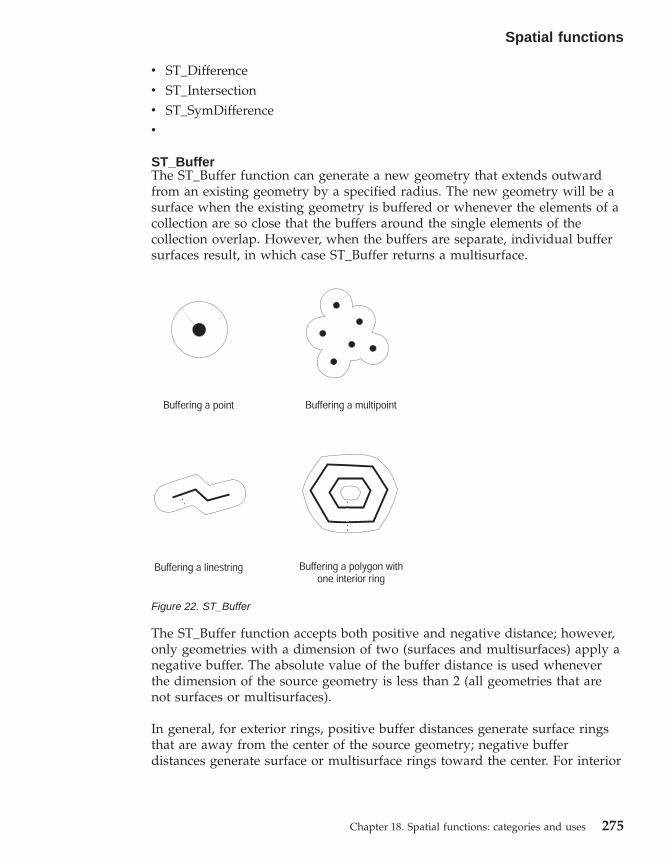
v ST_Differencev ST_Intersectionv ST_SymDifferencev
ST_BufferThe ST_Buffer function can generate a new geometry that extends outwardfrom an existing geometry by a specified radius. The new geometry will be asurface when the existing geometry is buffered or whenever the elements of acollection are so close that the buffers around the single elements of thecollection overlap. However, when the buffers are separate, individual buffersurfaces result, in which case ST_Buffer returns a multisurface.
The ST_Buffer function accepts both positive and negative distance; however,only geometries with a dimension of two (surfaces and multisurfaces) apply anegative buffer. The absolute value of the buffer distance is used wheneverthe dimension of the source geometry is less than 2 (all geometries that arenot surfaces or multisurfaces).
In general, for exterior rings, positive buffer distances generate surface ringsthat are away from the center of the source geometry; negative bufferdistances generate surface or multisurface rings toward the center. For interior
Figure 22. ST_Buffer
Spatial functions
Chapter 18. Spatial functions: categories and uses 275

rings of a surface or multisurface, a positive buffer distance generates a bufferring toward the center, and a negative buffer distance generates a buffer ringaway from the center.
The buffering process merges surfaces that overlap. Negative distances greaterthan one half the maximum interior width of a polygon result in an emptygeometry.
ST_ConvexHullThe ST_ConvexHull function returns the convex hull of any geometry that hasat least three vertices forming a convex. (Vertices are the pairs of X and Ycoordinates within geometries. A convex hull is the smallest convex polygonthat can be formed by all vertices within a given set of verticies.)
ST_DifferenceST_Difference takes two geometries of the same dimension as input. TheST_Difference function returns that portion of the first geometry that is notintersected by the second geometry. This operation is the spatial equivalent ofthe logical AND NOT. The portion of geometry returned by ST_Difference isitself a geometry—a collection that has the same dimension as the geometriestaken as input. If these two geometries are equal—that is, if they occupy thesame space— the returned geometry is empty.
Figure 23. ST_ConvexHull
Spatial functions
276 DB2 Spatial Extender User’s Guide and Reference
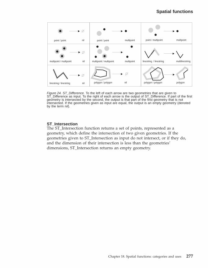
ST_IntersectionThe ST_Intersection function returns a set of points, represented as ageometry, which define the intersection of two given geometries. If thegeometries given to ST_Intersection as input do not intersect, or if they do,and the dimension of their intersection is less than the geometries’dimensions, ST_Intersection returns an empty geometry.
Figure 24. ST_Difference. To the left of each arrow are two geometries that are given toST_Difference as input. To the right of each arrow is the output of ST_Difference. If part of the firstgeometry is intersected by the second, the output is that part of the first geometry that is notintersected. If the geometries given as input are equal, the output is an empty geometry (denotedby the term nil).
Spatial functions
Chapter 18. Spatial functions: categories and uses 277

ST_SymDifferenceThe ST_SymDifference function returns the symmetric difference (the spatialequivalent of the logical XOR operation) of two intersecting geometries thathave the same dimension. If these geometries are equal, ST_SymDifferencereturns an empty geometry. If they are not equal, then a portion of one orboth of them will lie outside the area of intersection.
Functions for deriving individual geometries from multiple geometriesThe following functions derive individual geometries from multiplegeometries. For example, ST_Union combines two geometries into a singlegeometry.
Figure 25. ST_Intersection. To the left of each arrow are two intersecting geometries that are givento ST_Intersection as input. To the right of each arrow is the output of ST_Intersection—ageometry that represents the intersection created by the geometries at the left.
Spatial functions
278 DB2 Spatial Extender User’s Guide and Reference

These functions are:v MBR Aggregatev ST_Unionv Union Aggregate
MBR AggregateThe combination of the functions ST_BuildMBRAggr and ST_GetAggrResultaggregates a column of geometries in a selected column to a single geometryby constructing a rectangle that represents the minimum bounding rectanglethat encloses all the geometries in the column. Z and M coordinates arediscarded when the aggregate is computed.
ST_UnionThe ST_Union function returns the union set of two geometries. Thisoperation is the spatial equivalent of the logical OR. The two geometries mustbe of the same dimension. ST_Union always returns the result as a collection.
Union AggregateA union aggregate is the combination of the ST_BuildUnionAggr andST_GetAggrResult functions. This combination aggregates a column ofgeometries in a table to single geometry by constructing the union.
Functions for creating geometries based on measuresThe following functions can create geometries whose points are associatedwith a specific measure or with a specific sequence of two measures. Forexample, suppose that measures ranging from a value of 4 to a value of 8 arestored with the points in a multicurve. If you want to know with whichpoints a measure with a value of 7 is stored, you could use the FindMeasurefunction to return those points within a single multipoint.
These functions are:
Figure 26. ST_Union
Spatial functions
Chapter 18. Spatial functions: categories and uses 279

v ST_FindMeasure (also called ST_LocateAlong)v ST_MeasureBetween (also called ST_LocateBetween)
ST_FindMeasure or ST_LocateAlongST_FindMeasure or ST_LocateAlong takes a geometry and a measure as inputparameters and returns a multipoint or multicurve of that part of the givengeometry that has exactly the specified measure of the given geometry thatcontains the specified measure. For points and multipoints, all the points withthe specified measure are returned. For curves, multicurves, surfaces, andmultisurfaces, interpolation is performed to compute the result. Thecomputation for surfaces and multisurfaces is performed on the boundary ofthe geometry.
ST_MeasureBetween (also called ST_LocateBetween)ST_MeasureBetween or ST_LocateBetween takes a geometry and two Mcoordinates (measures) as input parameters and returns that part of the givengeometry that represents the set of disconnected paths or points between thetwo M coordinates.
For curves, multicurves, surfaces, and multisurfaces, interpolation isperformed to compute the result.
Functions for creating modified forms of geometriesThe following functions create modified forms of existing geometries. Forexample, the ST_AppendPoint function creates extended versions of existingcurves. Each version includes the points in an existing curve plus anadditional point.
These functions are:v ST_AppendPointv ST_ChangePointv ST_Generalizev ST_Mv ST_PerpPoints
Figure 27. LocateBetween
Spatial functions
280 DB2 Spatial Extender User’s Guide and Reference

v ST_RemovePointv ST_Xv ST_Yv ST_Z
ST_AppendPointST_AppendPoint takes a curve and a point as input parameters and extendsthe curve by the given point.
ST_ChangePointST_ChangePoint takes a curve and two points as input parameters. It replacesall occurrences of the first point in the given curve with the second point andreturns the resulting curve.
ST_GeneralizeST_Generalize takes a geometry and a threshold as input parameters andrepresents the given geometry with a reduced number of points, whilepreserving the general characteristics of the geometry. The Douglas-Deckerline-simplification algorithm is used, by which the sequence of points thatdefine the geometry is recursively subdivided until a run of the points can bereplaced by a straight line segment. In this line segment, none of the definingpoints deviates from the straight line segment by more than the giventhreshold. Z and M coordinates are not considered for the simplification.
ST_MIf a given point is not associated with a measure, ST_M can provide ameasure to be stored with the point. If the point has an associated measure,ST_M can replace this measure with another one.
ST_PerpPointsST_PerpPoints takes a curve or multicurve and a point as input parametersand returns the perpendicular projection of the given point on the curve ormulticurve. The point with the smallest distance between the given point andthe perpendicular point is returned. If two or more such perpendicularprojected points are equidistant from the given point, they are all returned.
ST_RemovePointST_RemovePoint takes a curve and a point as input parameters and returnsthe given curve with all points equal to the specified point removed from it. Ifthe given curve has Z or M coordinates, then the point must also have Z or Mcoordinates.
ST_XST_X can replace an point’s X coordinate with another X coordinate.
ST_YST_Y can replace a point’s Y coordinate with another Y coordinate.
Spatial functions
Chapter 18. Spatial functions: categories and uses 281

ST_ZIf a given point has no Z coordinate, ST_Z can add a Z coordinate to thepoint. If the point does have a Z coordinate, ST_Z can replace this coordinatewith another Z coordinate.
Miscellaneous spatial functions
Three spatial functions do not fit well in the categories that the other spatialfunctions belong to. They do not convert geometries’ formats, comparegeometries, return information about geometries’ properties, or creategeometries. They are:
ST_Distance:
ST_Distance takes two geometries and, optionally, a unit as input parametersand returns the shortest distance between any point in the first geometry toany point in the second geometry, measured in the given units.
If the second geometry is not represented in the same spatial reference systemas the first geometry, it will be converted to the other spatial reference system.
If any of the two given geometries is null or is empty, then null is returned.
For example, ST_Distance could report the shortest distance an aircraft musttravel between two locations. Figure 28 illustrates this information.
ST_GetIndexParms:
Figure 28. Minimum distance between two cities. ST_Distance can take the coordinates for thelocations of Los Angeles and Chicago as input, and return a value denoting the minimum distancebetween these locations.
Spatial functions
282 DB2 Spatial Extender User’s Guide and Reference

ST_GetIndexParms takes either the identifier for a spatial index or for aspatial column as an input parameter and returns the parameters used todefine the index or the index on the spatial column. If an additionalparameter number is specified, only the parameter identified by the number isreturned.
ST_Transform:
ST_Transform takes a geometry and a spatial reference system identifier asinput parameters and transforms the geometry to be represented in the givenspatial reference system. Projections and conversions between differentcoordinate systems are performed and the coordinates of the geometries areadjusted accordingly.
Spatial functions
Chapter 18. Spatial functions: categories and uses 283

Reference material
284 DB2 Spatial Extender User’s Guide and Reference
Chapter 19. Spatial functions: syntax and parameters
This section introduces the spatial functions described in the followingsections. It discusses certain factors that are common to all or most spatialfunctions. The functions are documented here in alphabetical order.
Spatial functions: considerations and associated data types
This section provides information that you need to know when you codespatial functions. This information includes:v Factors to consider: the requirement to specify the schema to which spatial
functions belong, and the fact that some functions can be invoked asmethods.
v How to address a situation in which a spatial function cannot process thetype of geometries returned by another spatial function.
v A table showing which functions take values of each spatial data type asinput
Factors to considerWhen you use spatial functions, be aware of these factors:v Before a spatial function can be called, its name must be qualified by the
name of the schema to which spatial functions belong: DB2GSE. One wayto do this is to explicitly specify the schema in the SQL statement thatreferences the function; for example:SELECT db2gse.ST_Relate (g1, g2, ’T*F**FFF2’) EQUALS FROM relate_test
Alternatively, to avoid specifying the schema each time a function is to becalled, you can add DB2GSE to the CURRENT FUNCTION PATH specialregister. To obtain the current settings for this special register, type thefollowing SQL command:VALUES CURRENT FUNCTION PATH
To update the CURRENT FUNCTION PATH special register with DB2GSE,issue the following SQL command:set CURRENT FUNCTION PATH = CURRENT FUNCTION PATH, db2gse
v Some spatial functions can be invoked as methods. In the following code,for example, ST_Area is invoked first as a function and then as a method.In both cases, ST_Area is coded to operate on a polygon that has an ID of10 and that is stored in the SALES_ZONE column of a table named
© Copyright IBM Corp. 1998 - 2002 285

STORES. When invoked, ST_Area will return the area of the real-worldfeature—Sales Zone no. 10—that the polygon represents.ST_Area invoked as a function:SELECT ST_Area(sales_zone)FROM storesWHERE id = 10
ST_Area invoked as a method:SELECT sales_zone..ST_Area()FROM storesWHERE id = 10
Treating values of ST_Geometry as values of a subtypeIf a spatial function returns a geometry whose static type is a super type, andif the geometry is passed to a function that accepts only geometries of a typethat is subordinate to this super type, a compile-time exception is raised.
For example, the static type of the output parameter of the ST_Union functionis ST_Geometry, the super type of all spatial data types. The static inputparameter for the ST_PointOnSurface function can be either ST_Polygon orST_MultiPolygon, two subtypes of ST_Geometry. If DB2® attempts to passgeometries returned by ST_Union to ST_PointOnSurface, DB2 raises thefollowing compile-time exception:SQL00440N No function by the name "ST_POINTONSURFACE"having compatible arguments was found in the functionpath. SQLSTATE=42884
This message indicates that DB2 could not find a function that is namedST_PointOnSurface and that has an input parameter of ST_Geometry.
To let geometries of a super type pass to functions that accept only subtypesof the super type, use the TREAT operator. As indicated earlier, ST_Unionreturns geometries of a static type of ST_Geometry. It can also returngeometries of a dynamic subtype of ST_Geometry. Suppose, for example, thatit returns a geometry with a dynamic type of ST_MultiPolygon. In that case,the TREAT operator requires that this geometry be used with the static typeST_MultiPolygon. This matches one of the data types of the input parameterof ST_PointOnSurface. If ST_Union does not return an ST_MultiPolygonvalue, DB2 raises a run-time exception.
If a function returns a geometry of a super type, the TREAT operatorgenerally can tell DB2 to regard this geometry as a subtype of this super type.But be aware that this operation succeeds only if the subtype matches or issubordinate to a static subtype defined as an input parameter of the functionto which the geometry is passed. If this condition is not met, DB2 raises arun-time exception.
Considerations for spatial functions
286 DB2 Spatial Extender User’s Guide and Reference
Consider another example: suppose that you want to determine theperpendicular points for a given point on the boundary of a polygon that hasno holes. You use the ST_Boundary function to derive the boundary from thepolygon. The static output parameter of ST_Boundary is ST_Geometry, butST_PerpPoints accepts ST_Curve geometries. Because all polygons have alinestring (which is also a curve) as a boundary, and because the data type oflinestrings (ST_LineString) is subordinate to ST_Curve, the followingoperation will let an ST_Geometry polygon returned by ST_Boundary pass toST_PerpPoints:SELECT ST_AsText(ST_PerpPoints(TREAT(ST_Boundary(polygon) as ST_Curve)),
ST_Point(30.5, 65.3, 1)))FROM polygon_table
Instead of invoking ST_Boundary and ST_PerpPoints as functions, you caninvoke them as methods. To do so, specify the following code:SELECT TREAT(ST_Boundary(polygon) as ST_Curve)..
ST_PerpPoints(St_Point(30.5, 65.3, ))..ST_AsText()FROM polygon_table
Spatial functions listed according to input typeTable 39 on page 288 lists the spatial functions according to the type of inputthat they can accept.
IMPORTANT: As noted elsewhere, the spatial data types form a hierarchy,with ST_Geometry as the root. When the documentation for DB2 SpatialExtender indicates that a value of a super type in this hierarchy can be usedas input to a function, alternatively, a value of any subtype of this super typecan also be used as input to the function.
For example, the first entries in Table 39 on page 288 indicate that ST_Areaand a number of other functions can take values of the ST_Geometry datatype as input. Therefore, input to these functions can also be values of anysubtype of ST_Geometry: ST_Point, ST_Curve, ST_LineString, and so on.
Considerations for spatial functions
Chapter 19. Spatial functions: syntax and parameters 287
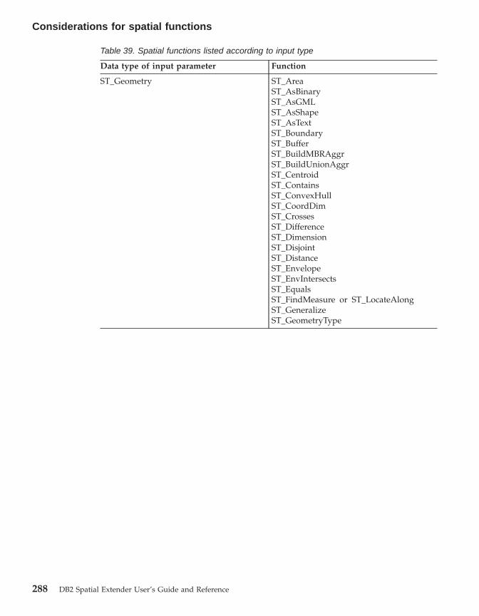
Table 39. Spatial functions listed according to input type
Data type of input parameter Function
ST_Geometry ST_AreaST_AsBinaryST_AsGMLST_AsShapeST_AsTextST_BoundaryST_BufferST_BuildMBRAggrST_BuildUnionAggrST_CentroidST_ContainsST_ConvexHullST_CoordDimST_CrossesST_DifferenceST_DimensionST_DisjointST_DistanceST_EnvelopeST_EnvIntersectsST_EqualsST_FindMeasure or ST_LocateAlongST_GeneralizeST_GeometryType
Considerations for spatial functions
288 DB2 Spatial Extender User’s Guide and Reference

Table 39. Spatial functions listed according to input type (continued)
Data type of input parameter Function
ST_Geometry, continued ST_IntersectionST_IntersectsST_Is3DST_IsEmptyST_IsMeasuredST_IsSimpleST_IsValidST_MaxMST_MaxXST_MaxYST_MaxZST_MBRST_MBRIntersectsST_MeasureBetween or ST_LocateBetweenST_MinMST_MinXST_MinYST_MinZST_NumPointsST_OverlapsST_RelateST_SRID or ST_SrsIdST_SrsNameST_SymDifferenceST_SymmetricDiffST_ToGeomCollST_ToLineStringST_ToMultiLineST_ToMultiPointST_ToMultiPolygonST_ToPointST_ToPolygonST_TouchesST_TransformST_UnionST_Within
ST_Point ST_MST_XST_YST_Z
Considerations for spatial functions
Chapter 19. Spatial functions: syntax and parameters 289

Table 39. Spatial functions listed according to input type (continued)
Data type of input parameter Function
ST_Curve ST_AppendPointST_ChangePointST_EndPointST_IsClosedST_IsRingST_LengthST_MidPointST_PerpPointsST_RemovePointST_StartPoint
ST_LineString ST_PointNST_Polygon
ST_Surface ST_PerimeterST_PointOnSurface
ST_GeomCollection ST_GeometryNST_NumGeometries
ST_MultiPoint ST_PointN
ST_MultiCurve ST_IsClosedST_LengthST_PerpPoints
ST_MultiLineString ST_LineStringNST_NumLineStringsST_Polygon
ST_MultiSurface ST_PerimeterST_PointOnSurface
ST_MultiPolygon ST_NumPolygonsST_PolygonN
Related reference:
v “ST_Boundary” on page 302v “ST_Area” on page 294v “ST_PerpPoints” on page 434v “ST_Point” on page 437v “ST_PointOnSurface” on page 444v “ST_Relate” on page 453v “ST_Union” on page 475
Considerations for spatial functions
290 DB2 Spatial Extender User’s Guide and Reference

MBR Aggregate
The combination of the functions ST_BuildMBRAggr and ST_GetAggrResultaggregates a column of geometries in a selected column to a single geometryby constructing a rectangle that represents the minimum bounding rectanglethat encloses all the geometries in the column. Z and M coordinates arediscarded when the aggregate is computed.
If all of the geometries to be combined are null, then null is returned. If all ofthe geometries are either null or empty, then an empty geometry is returned.If the minimum bounding rectangle of all the geometries to be combinedresults in a point, then this point is returned as an ST_Point value. If theminimum bounding rectangle of all the geometries to be combined results in ahorizontal or vertical linestring, then this linestring is returned as anST_LineString value. Otherwise, the minimum bounding rectangle is returnedas an ST_Polygon value.
Syntax:
�� db2gse.ST_GetAggrResult ( MAX ( �
� db2gse.ST_BuildMBRAggr ( geometries ) ) ) ��
Parameter:
geometriesA selected column that has a type of ST_Geometry or one of itssubtypes and represents all the geometries for which the minimumbounding rectangle is to be computed.
Return type:
db2gse.ST_Geometry
Restrictions:
You cannot construct the union aggregate of a spatial column in a full-selectin any of the following situations:v In an MPP environment.v If GROUP BY clause is used in the full-select.v If you use a function other than the DB2 aggregate function MAX.
Example:
MBR Aggregate
Chapter 19. Spatial functions: syntax and parameters 291

In the following example, the lines of results have been reformatted forreadability. The spacing in your results will vary according to your onlinedisplay.
This example shows how to use the ST_BuildMBRAggr function to obtain themaximum bounding rectangle of all of the geometries within a column. In thisexample, several points are added to the GEOMETRY column in theSAMPLE_POINTS table. The SQL code then determines the maximumbounding rectangle of all of the points put together.SET CURRENT FUNCTION PATH = CURRENT FUNCTION PATH, db2gse
CREATE TABLE sample_points (id integer, geometry ST_Point)
INSERT INTO sample_points (id, geometry)VALUES
(1, ST_Point(2, 3, 1)),(2, ST_Point(4, 5, 1)),(3, ST_Point(13, 15, 1)),(4, ST_Point(12, 5, 1)),(5, ST_Point(23, 2, 1)),(6, ST_Point(11, 4, 1))
SELECT cast(ST_GetAggrResult(MAX(ST_BuildMBRAggr(geometry)))..ST_AsText AS varchar(160))AS ";Aggregate_of_Points";
FROM sample_points
Results:Aggregate_of_Points----------------------------------------------------------POLYGON (( 2.00000000 2.00000000, 23.00000000 2.00000000,23.00000000 15.00000000, 2.00000000 15.00000000, 2.000000002.00000000))
ST_AppendPoint
ST_AppendPoint takes a curve and a point as input parameters and extendsthe curve by the given point. If the given curve has Z or M coordinates, thenthe point must also have Z or M coordinates. The resulting curve isrepresented in the spatial reference system of the given curve.
If the point to be appended is not represented in the same spatial referencesystem as the curve, it will be converted to the other spatial reference system.
If the given curve is closed or simple, the resulting curve might not be closedor simple anymore. If the given curve or point is null, or if the curve is empty,
MBR Aggregate
292 DB2 Spatial Extender User’s Guide and Reference
then null is returned. If the point to be appended is empty, then the givencurve is returned unchanged and a warning is raised (SQLSTATE 01HS3).
This function can also be called as a method.
Syntax:
�� db2gse.ST_AppendPoint ( curve , point ) ��
Parameter:
curve A value of type ST_Curve or one of its subtypes that represents thecurve to which point will be appended.
point A value of type ST_Point that represents the point that is appended tocurve.
Return type:
db2gse.ST_Curve
Examples:
In the following example, the lines of results have been reformatted forreadability. The spacing in your results will vary according to your onlinedisplay.
This code creates two linestrings, each with three points.SET CURRENT FUNCTION PATH = CURRENT FUNCTION PATH, db2gseCREATE TABLE sample_lines(id integer, line ST_Linestring)
INSERT INTO sample_lines VALUES(1, ST_LineString(’linestring (10 10, 10 0, 0 0 )’, 0) )
INSERT INTO sample_lines VALUES(2, ST_LineString(’linestring z (0 0 4, 5 5 5, 10 10 6)’, 0) )
Example 1:
This example adds the point (5, 5) to the end of a linestring.SELECT CAST(ST_AsText(ST_AppendPoint(line, ST_Point(5, 5)))
AS VARCHAR(120)) NewFROM sample_linesWHERE id=1
Results:
ST_AppendPoint
Chapter 19. Spatial functions: syntax and parameters 293

NEW--------------------------------------------------------------LINESTRING ( 10.00000000 10.00000000, 10.00000000 0.00000000,0.00000000 0.00000000, 5.00000000 5.00000000)
Example 2:
This example adds the point (15, 15, 7) to the end of a linestring with Zcoordinates.SELECT CAST(ST_AsText(ST_AppendPoint(line, ST_Point(15.0, 15.0, 7.0)))
AS VARCHAR(160)) NewFROM sample_linesWHERE id=2
Results:NEW----------------------------------------------------------------LINESTRING Z ( 0.00000000 0.00000000 4.00000000, 5.000000005.00000000 5.00000000, 10.00000000 10.00000000 6.00000000,15.00000000 15.00000000 7.00000000)
ST_Area
ST_Area takes a geometry and, optionally, a unit as input parameters andreturns the area covered by the given geometry in the given unit of measure.
If the geometry is a polygon or multipolygon, then the area covered by thegeometry is returned. The area of points, linestrings, multipoints, andmultilinestrings is 0 (zero). If the geometry is null or is an empty geometry,then null is returned.
This function can also be called as a method.
Syntax:
�� db2gse.ST_Area ( geometry ), unit
��
Parameter:
geometryA value of type ST_Geometry or one of its subtypes that representsthe geometry that determines the area.
unit A VARCHAR(128) value that identifies the units in which the area ismeasured. The supported units of measure are listed in theDB2GSE.ST_UNITS_OF_MEASURE catalog view.
ST_AppendPoint
294 DB2 Spatial Extender User’s Guide and Reference

If the unit parameter is omitted, the following rules are used todetermine the unit in which the area is measured:v If geometry is in a projected or geocentric coordinate system, the
linear unit associated with this coordinate system is used.v If geometry is in a geographic coordinate system, the angular unit
associated with this coordinate system is used.
If the geometry is in an unspecified coordinate system and the unit parameteris specified, or if the geometry is in a geographic coordinate system and alinear unit is specified, then an error is returned (SQLSTATE 38SU4).
Return type:
DOUBLE
Examples:
Example 1:
The spatial analyst needs a list of the area covered by each sales region. Thesales region polygons are stored in the SAMPLE_POLYGONS table. The areais calculated by applying the ST_Area function to the geometry column.db2se create_srs se_bank -srsId 4000 -srsName new_york1983 -xOffset 0
-yOffset 0 -xScale 1 -yScale 1-coordsysName NAD_1983_StatePlane_New_York_East_FIPS_3101_Feet
CREATE TABLE sample_polygons (id INTEGER, geometry ST_POLYGON)
INSERT INTO sample_polygons (id, geometry)VALUES
(1, ST_Polygon(’polygon((0 0, 0 10, 10 10, 10 0, 0 0))’, 4000) ),(2, ST_Polygon(’polygon((20 0, 30 20, 40 0, 20 0 ))’, 4000) ),(3, ST_Polygon(’polygon((20 30, 25 35, 30 30, 20 30))’, 4000))
The following SELECT statement selects the sales region ID and area:SELECT id, ST_Area(geometry) AS areaFROM sample_polygons
Results:ID AREA-------- ------------------------
1 +1.00000000000000E+0022 +2.00000000000000E+0023 +2.50000000000000E+001
Example 2:
ST_Area
Chapter 19. Spatial functions: syntax and parameters 295
The following SELECT statement selects the sales region ID and area invarious units:SELECT id,
ST_Area(geometry) square_feet,ST_Area(geometry, ’METER’) square_meters,ST_Area(geometry, ’STATUTE MILE’) square_miles
FROM sample_polygons
Results:ID SQUARE_FEET SQUARE_METERS SQUARE_MILES--- ------------------------ ------------------------ ------------------------
1 +1.00000000000000E+002 +9.29034116132748E+000 +3.58702077598427E-0062 +2.00000000000000E+002 +1.85806823226550E+001 +7.17404155196855E-0063 +2.50000000000000E+001 +2.32258529033187E+000 +8.96755193996069E-007
Example 3:
This example finds the area of a polygon defined in State Plane coordinates.
The State Plane spatial reference system with an ID of 3 is created with thefollowing call to db2se:db2se create_srs SAMP_DB -srsId 3 -srsName z3101a -xOffset 0
-yOffset 0 -xScale 1 -yScale 1-coordsysName NAD_1983_StatePlane_New_York_East_FIPS_3101_Feet
The following code adds the polygon, in spatial reference system 3, to thetable and determines the area in square feet, square meters, and square miles.SET current function path db2gse;CREATE TABLE Sample_Poly3 (id integer, geometry ST_Polygon);INSERT into Sample_Poly3 VALUES
(1, ST_Polygon(’polygon((567176.0 1166411.0,567176.0 1177640.0,637948.0 1177640.0,637948.0 1166411.0,567176.0 1166411.0 ))’, 3));
SELECT id, ST_Area(geometry) "Square Feet",ST_Area(geometry, ’METER’) "Square Meters",ST_Area(geometry, ’STATUTE MILE’) "Square Miles"
FROM Sample_Poly3;
Results:ID Square Feet Square Meters Square Miles--- ------------------------ ------------------------ ------------------------1 +7.94698788000000E+008 +7.38302286101346E+007 +2.85060106320552E+001
Related reference:
v “The DB2GSE.ST_UNITS_OF_MEASURE catalog view” on page 242
ST_Area
296 DB2 Spatial Extender User’s Guide and Reference
ST_AsBinary
ST_AsBinary takes a geometry as an input parameter and returns itswell-known binary representation. The Z and M coordinates are discardedand will not be represented in the well-known binary representation.
If the given geometry is null, then null is returned.
This function can also be called as a method.
Syntax:
�� db2gse.ST_AsBinary ( geometry ) ��
Parameter:
geometryA value of type ST_Geometry or one of its subtypes to be convertedto the corresponding well-known binary representation.
Return type:
BLOB(2G)
Examples:
The following code illustrates how to use the ST_AsBinary function to convertthe points in the geometry columns of the SAMPLE_POINTS table intowell-known binary (WKB) representation in the BLOB column.CREATE TABLE SAMPLE_POINTS (id integer, geometry ST_POINT, wkb BLOB(32K))
INSERT INTO SAMPLE_POINTS (id, geometry)VALUES
(1100, ST_Point(10, 20, 1))
Example 1:
This example populates the WKB column, with an ID of 1111, from theGEOMETRY column, with an ID of 1100.INSERT INTO sample_points(id, wkb)VALUES (1111,
(SELECT ST_AsBinary(geometry)FROM sample_pointsWHERE id = 1100))
ST_AsBinary
Chapter 19. Spatial functions: syntax and parameters 297
SELECT id, cast(ST_Point(wkb)..ST_AsText AS varchar(35)) AS pointFROM sample_pointsWHERE id = 1111
Results:ID Point----------- -----------------------------------
1111 POINT ( 10.00000000 20.00000000)
Example 2:
This example displays the WKB binary representation.SELECT id, substr(ST_AsBinary(geometry), 1, 21) AS point_wkbFROM sample_pointsWHERE id = 1100
Results:ID POINT_WKB------ ---------------------------------------------
1100 x’010100000000000000000024400000000000003440’
Related reference:
v “Well-known binary (WKB) representation” on page 503
ST_AsGML
ST_AsGML takes a geometry as an input parameter and returns itsrepresentation using the geography markup language.
If the given geometry is null, then null is returned.
This function can also be called as a method.
Syntax:
�� db2gse.ST_AsGML ( geometry ) ��
Parameter:
geometryA value of type ST_Geometry or one of its subtypes to be convertedto the corresponding GML representation.
Return type:
CLOB(2G)
ST_AsBinary
298 DB2 Spatial Extender User’s Guide and Reference

Example:
In the following example, the lines of results have been reformatted forreadability. The spacing in your results will vary according to your onlinedisplay.
The following code fragment illustrates how to use the ST_AsGML function toview the GML fragment. This example populates the GML column, from thegeometry column, with an ID of 2222.SET CURRENT FUNCTION PATH = CURRENT FUNCTION PATH, db2gse
CREATE TABLE SAMPLE_POINTS (id integer, geometry ST_POINT, gml CLOB(32K))
INSERT INTO SAMPLE_POINTS (id, geometry)VALUES
(1100, ST_Point(10, 20, 1))
INSERT INTO sample_points(id, gml)VALUES (2222,
(SELECT ST_AsGML(geometry)FROM sample_pointsWHERE id = 1100))
The following SELECT statement lists the ID and the GML representation ofthe geometries. The geometry is converted to a GML fragment by theST_AsGML function.SELECT id, cast(ST_AsGML(geometry) AS varchar(110)) AS gml_fragmentFROM sample_pointsWHERE id = 1100
Results:The SELECT statement returns the following result set:
ID GML_FRAGMENT
----------- ------------------------------------------------------------1100 <gml:Point srsName";EPSG:4269";><gml:coord>
<gml:X>10</gml:X><gml:Y>20</gml:Y></gml:coord></gml:Point>
Related reference:
v “Spatial functions that convert geometries to and from data exchangeformats” on page 243
v “Geography Markup Language (GML) representation” on page 505
ST_AsGML
Chapter 19. Spatial functions: syntax and parameters 299

ST_AsShape
ST_AsShape takes a geometry as an input parameter and returns its ESRIshape representation.
If the given geometry is null, then null is returned.
This function can also be called as a method.
Syntax:
�� db2gse.ST_AsShape ( geometry ) ��
Parameter:
geometryA value of type ST_Geometry or one of its subtypes to be convertedto the corresponding ESRI shape representation.
Return type:
BLOB(2G)
Example:
The following code fragment illustrates how to use the ST_AsShape functionto convert the points in the geometry column of the SAMPLE_POINTS tableinto shape binary representation in the shape BLOB column. This examplepopulates the shape column from the geometry column. The shape binaryrepresentation is used to display the geometries in geobrowsers, which requiregeometries to comply with the ESRI shapefile format, or to construct thegeometries for the *.SHP file of the shape file.SET CURRENT FUNCTION PATH = CURRENT FUNCTION PATH, db2gse
CREATE TABLE SAMPLE_POINTS (id integer, geometry ST_POINT, shape BLOB(32K))
INSERT INTO SAMPLE_POINTS (id, geometry)VALUES
(1100, ST_Point(10, 20, 1))
INSERT INTO sample_points(id, shape)VALUES (2222,
(SELECT ST_AsShape(geometry)FROM sample_pointsWHERE id = 1100))
SELECT id, substr(ST_AsShape(geometry), 1, 20) AS shapeFROM sample_pointsWHERE id = 1100
ST_AsShape
300 DB2 Spatial Extender User’s Guide and Reference
Returns:ID SHAPE
------ -------------------------------------------1100 x’0100000000000000000024400000000000003440’
Related reference:
v “Shape representation” on page 505
ST_AsText
ST_AsText takes a geometry as an input parameter and returns its well-knowntext representation.
If the given geometry is null, then null is returned.
This function can also be called as a method.
Syntax:
�� db2gse.ST_AsText ( geometry ) ��
Parameter:
geometryA value of type ST_Geometry or one of its subtypes to be convertedto the corresponding well-known text representation.
Return type:
CLOB(2G)
Example:
In the following example, the lines of results have been reformatted forreadability. The spacing in your results will vary according to your onlinedisplay.
After capturing and inserting the data into the SAMPLE_GEOMETRIES table,an analyst wants to verify that the values inserted are correct by looking atthe well-known text representation of the geometries.SET CURRENT FUNCTION PATH = CURRENT FUNCTION PATH, db2gse
CREATE TABLE sample_geometries(id SMALLINT, spatial_type varchar(18),geometry ST_GEOMETRY)
INSERT INTO sample_geometries(id, spatial_type, geometry)
ST_AsShape
Chapter 19. Spatial functions: syntax and parameters 301
VALUES(1, ’st_point’, ST_Point(50, 50, 0)),(2, ’st_linestring’, ST_LineString(’linestring
(200 100, 210 130, 220 140)’, 0)),(3, ’st_polygon’, ST_Polygon(’polygon((110 120, 110 140,
130 140, 130 120, 110 120))’, 0))
The following SELECT statement lists the spatial type and the WKTrepresentation of the geometries. The geometry is converted to text by theST_AsText function. It is then cast to a varchar(120) because the default outputof the ST_AsText function is CLOB(2G).SELECT id, spatial_type, cast(geometry..ST_AsText
AS varchar(150)) AS wktFROM sample_geometries
Results:ID SPATIAL_TYPE WKT------ ------------------ ------------------------------------------------
1 st_point POINT ( 50.00000000 50.00000000)
2 st_linestring LINESTRING ( 200.00000000 100.00000000,210.00000000 130.00000000, 220.00000000140.00000000)
3 st_polygon POLYGON (( 110.00000000 120.00000000,130.00000000 120.00000000, 130.00000000140.00000000, 110.00000000140.00000000,110.00000000 120.00000000))
Related reference:
v “Well-known text (WKT) representation” on page 497
ST_Boundary
ST_Boundary takes a geometry as an input parameter and returns itsboundary as a new geometry. The resulting geometry is represented in thespatial reference system of the given geometry.
If the given geometry is a point, multipoint, closed curve, or closedmulticurve, or if it is empty, then the result is an empty geometry of typeST_Point. For curves or multicurves that are not closed, the start points andend points of the curves are returned as an ST_MultiPoint value, unless sucha point is the start or end point of an even number of curves. For surfaces andmultisurfaces, the curve defining the boundary of the given geometry isreturned, either as an ST_Curve or an ST_MultiCurve value. If the givengeometry is null, then null is returned.
ST_AsText
302 DB2 Spatial Extender User’s Guide and Reference

If possible, the specific type of the returned geometry will be ST_Point,ST_LineString, or ST_Polygon. For example, the boundary of a polygon withno holes is a single linestring, represented as ST_LineString. The boundary ofa polygon with one or more holes consists of multiple linestrings, representedas ST_MultiLineString.
This function can also be called as a method.
Syntax:
�� db2gse.ST_Boundary ( geometry ) ��
Parameter:
geometryA value of type ST_Geometry or one of its subtypes. The boundary ofthis geometry is returned.
Return type:
db2gse.ST_Geometry
Example:
In the following example, the lines of results have been reformatted forreadability. The spacing in your results will vary according to your onlinedisplay.
This example creates several geometries and determines the boundary of eachgeometry.SET CURRENT FUNCTION PATH = CURRENT FUNCTION PATH, db2gseCREATE TABLE sample_geoms (id INTEGER, geometry ST_Geometry)
INSERT INTO sample_geoms VALUES(1, ST_Polygon(’polygon((40 120, 90 120, 90 150, 40 150, 40 120))’, 0))
INSERT INTO sample_geoms VALUES(2, ST_Polygon(’polygon((40 120, 90 120, 90 150, 40 150, 40 120),
(70 130, 80 130, 80 140, 70 140, 70 130))’ ,0))
INSERT INTO sample_geoms VALUES(3, ST_Geometry(’linestring(60 60, 65 60, 65 70, 70 70)’ ,0))
INSERT INTO sample_geoms VALUES(4, ST_Geometry(’multilinestring((60 60, 65 60, 65 70, 70 70),
(80 80, 85 80, 85 90, 90 90),(50 50, 55 50, 55 60, 60 60))’ ,0))
INSERT INTO sample_geoms VALUES(5, ST_Geometry(’point(30 30)’ ,0))
SELECT id, CAST(ST_AsText(ST_Boundary(geometry)) as VARCHAR(320)) BoundaryFROM sample_geoms
Results
ST_Boundary
Chapter 19. Spatial functions: syntax and parameters 303
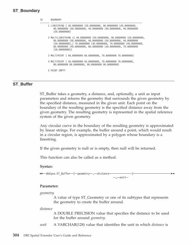
ID BOUNDARY------- --------------------------------------------------------------------
1 LINESTRING ( 40.00000000 120.00000000, 90.00000000 120.00000000,90.00000000 150.00000000, 40.00000000 150.00000000, 40.00000000120.00000000)
2 MULTILINESTRING (( 40.00000000 120.00000000, 90.00000000 120.00000000,90.00000000 150.00000000, 40.00000000 150.00000000, 40.00000000120.00000000),( 70.00000000 130.00000000, 70.00000000 140.00000000,80.00000000 140.00000000, 80.00000000 130.00000000, 70.00000000130.00000000))
3 MULTIPOINT ( 60.00000000 60.00000000, 70.00000000 70.00000000)
4 MULTIPOINT ( 50.00000000 50.00000000, 70.00000000 70.00000000,80.00000000 80.00000000, 90.00000000 90.00000000)
5 POINT EMPTY
ST_Buffer
ST_Buffer takes a geometry, a distance, and, optionally, a unit as inputparameters and returns the geometry that surrounds the given geometry bythe specified distance, measured in the given unit. Each point on theboundary of the resulting geometry is the specified distance away from thegiven geometry. The resulting geometry is represented in the spatial referencesystem of the given geometry.
Any circular curve in the boundary of the resulting geometry is approximatedby linear strings. For example, the buffer around a point, which would resultin a circular region, is approximated by a polygon whose boundary is alinestring.
If the given geometry is null or is empty, then null will be returned.
This function can also be called as a method.
Syntax:
�� db2gse.ST_Buffer ( geometry , distance ), unit
��
Parameter:
geometryA value of type ST_Geometry or one of its subtypes that representsthe geometry to create the buffer around.
distanceA DOUBLE PRECISION value that specifies the distance to be usedfor the buffer around geometry.
unit A VARCHAR(128) value that identifies the unit in which distance is
ST_Boundary
304 DB2 Spatial Extender User’s Guide and Reference

measured. The supported units of measure are listed in theDB2GSE.ST_UNITS_OF_MEASURE catalog view.
If the unit parameter is omitted, the following rules are used to determine theunit of measure used for distance:v If geometry is in a projected or geocentric coordinate system, the linear unit
associated with this coordinate system is used.v If geometry is in a geographic coordinate system, the angular unit associated
with this coordinate system is used.
If the geometry is in an unspecified coordinate system and the unit parameteris specified, or if the geometry is in a geographic coordinate system and alinear unit is specified, then an error is returned (SQLSTATE 38SU4).
Return type:
db2gse.ST_Geometry
Examples:
In the following examples, the lines of results have been reformatted forreadability. The spacing in your results will vary according to your onlinedisplay.
The following code creates a spatial reference system, creates theSAMPLE_GEOMETRIES table, and populates it.db2se create_srs se_bank -srsId 4000 -srsName new_york1983
-xOffset 0 -yOffset 0 -xScale 1 -yScale 1-coordsysName NAD_1983_StatePlane_New_York_East_FIPS_3101_Feet
SET CURRENT FUNCTION PATH = CURRENT FUNCTION PATH, db2gse
CREATE TABLEsample_geometries (id INTEGER, spatial_type varchar(18),geometry ST_GEOMETRY)
INSERT INTO sample_geometries(id, spatial_type, geometry)VALUES
(1, ’st_point’, ST_Point(50, 50, 4000)),(2, ’st_linestring’,
ST_LineString(’linestring(200 100, 210 130,220 140)’, 4000)),
(3, ’st_polygon’,ST_Polygon(’polygon((110 120, 110 140, 130 140,130 120, 110 120))’,4000)),
(4, ’st_multipolygon’,ST_MultiPolygon(’multipolygon(((30 30, 30 40,35 40, 35 30, 30 30),(35 30, 35 40, 45 40,45 30, 35 30)))’, 4000))
ST_Buffer
Chapter 19. Spatial functions: syntax and parameters 305

Example 1:
The following SELECT statement uses the ST_Buffer function to apply abuffer of 10.SELECT id, spatial_type,
cast(geometry..ST_Buffer(10)..ST_AsText AS varchar(470)) AS buffer_10FROM sample_geometries
Results:ID SPATIAL_TYPE BUFFER_10----------- ------------------ ------------------------------------------1 st_point POLYGON (( 60.00000000 50.00000000,
59.00000000 55.00000000, 54.00000000 59.00000000, 49.0000000060.00000000, 44.00000000 58.00000000, 41.00000000 53.00000000,40.00000000 48.00000000,42.00000000 43.00000000, 47.0000000041.00000000, 52.00000000 40.00000000, 57.00000000 42.00000000,60.00000000 50.00000000))
2 st_linestring POLYGON (( 230.00000000140.00000000, 229.00000000 145.00000000, 224.00000000149.00000000, 219.00000000 150.00000000, 213.00000000 147.00000000,203.00000000 137.00000000, 201.00000000 133.00000000, 191.00000000103.00000000, 191.00000000 99.00000000, 192.00000000 95.00000000,196.00000000 91.00000000, 200.00000000 91.00000000,204.0000000091.00000000, 209.00000000 97.00000000, 218.00000000 124.00000000,227.00000000 133.00000000, 230.00000000 140.00000000))
3 st_polygon POLYGON (( 140.00000000 120.00000000,140.00000000 140.00000000, 139.00000000 145.00000000, 130.00000000150.00000000, 110.00000000 150.00000000, 105.00000000 149.00000000,100.00000000 140.00000000,100.00000000 120.00000000, 101.00000000115.00000000, 110.00000000 110.00000000,130.00000000 110.00000000,135.00000000 111.00000000, 140.00000000 120.00000000))
4 st_multipolygon POLYGON (( 55.00000000 30.00000000,55.00000000 40.00000000, 54.00000000 45.00000000, 45.0000000050.00000000, 30.00000000 50.00000000, 25.00000000 49.00000000,20.00000000 40.00000000, 20.00000000 30.00000000, 21.0000000025.00000000, 30.00000000 20.00000000, 45.00000000 20.00000000,50.00000000 21.00000000, 55.00000000 30.00000000))
Example 2:
The following SELECT statement uses the ST_Buffer function to apply anegative buffer of 5.SELECT id, spatial_type,
cast(ST_AsText(ST_Buffer(geometry, -5)) AS varchar(150))AS buffer_negative_5
FROM sample_geometriesWHERE id = 3
ST_Buffer
306 DB2 Spatial Extender User’s Guide and Reference
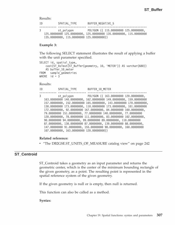
Results:ID SPATIAL_TYPE BUFFER_NEGATIVE_5----------- ------------------ --------------------------------------3 st_polygon POLYGON (( 115.00000000 125.00000000,
125.00000000 125.00000000, 125.00000000 135.00000000, 115.00000000135.00000000, 115.00000000 125.00000000))
Example 3:
The following SELECT statement illustrates the result of applying a bufferwith the unit parameter specified.SELECT id, spatial_type,
cast(ST_AsText(ST_Buffer(geometry, 10, ’METER’)) AS varchar(680))AS buffer_10_meter
FROM sample_geometriesWHERE id = 3
Results:ID SPATIAL_TYPE BUFFER_10_METER----------- ------------------ --------------------------------------3 st_polygon POLYGON (( 163.00000000 120.00000000,
163.00000000 140.00000000, 162.00000000 149.00000000, 159.00000000157.00000000, 152.00000000 165.00000000, 143.00000000 170.00000000,130.00000000 173.00000000, 110.00000000 173.00000000, 101.00000000172.00000000, 92.00000000 167.00000000, 84.00000000 160.00000000,79.00000000 151.00000000, 77.00000000 140.00000000, 77.00000000120.00000000, 78.00000000 111.00000000, 83.00000000 102.00000000,90.00000000 94.00000000, 99.00000000 89.00000000, 110.0000000087.00000000, 130.00000000 87.00000000, 139.00000000 88.00000000,147.00000000 91.00000000, 155.00000000 98.00000000, 160.00000000107.00000000, 163.00000000 120.00000000))
Related reference:
v “The DB2GSE.ST_UNITS_OF_MEASURE catalog view” on page 242
ST_Centroid
ST_Centroid takes a geometry as an input parameter and returns thegeometric center, which is the center of the minimum bounding rectangle ofthe given geometry, as a point. The resulting point is represented in thespatial reference system of the given geometry.
If the given geometry is null or is empty, then null is returned.
This function can also be called as a method.
Syntax:
ST_Buffer
Chapter 19. Spatial functions: syntax and parameters 307

�� db2gse.ST_Centroid ( geometry ) ��
Parameter:
geometryA value of type ST_Geometry or one of its subtypes that representsthe geometry to determine the geometric center.
Return type:
db2gse.ST_Point
Example:
This example creates two geometries and finds the centroid of them.SET CURRENT FUNCTION PATH = CURRENT FUNCTION PATH, db2gseCREATE TABLE sample_geoms (id INTEGER, geometry ST_Geometry)
INSERT INTO sample_geoms VALUES(1, ST_Polygon(’polygon((40 120, 90 120, 90 150, 40 150, 40 120),(50 130, 80 130, 80 140, 50 140, 50 130))’,0))
INSERT INTO sample_geoms VALUES(2, ST_MultiPoint(’multipoint(10 10, 50 10, 10 30)’ ,0))
SELECT id, CAST(ST_AsText(ST_Centroid(geometry))as VARCHAR(40)) Centroid
FROM sample_geoms
Results:ID CENTROID----------- ----------------------------------------
1 POINT ( 65.00000000 135.00000000)2 POINT ( 30.00000000 20.00000000)
ST_ChangePoint
ST_ChangePoint takes a curve and two points as input parameters. It replacesall occurrences of the first point in the given curve with the second point andreturns the resulting curve. The resulting geometry is represented in thespatial reference system of the given geometry.
If the two points are not represented in the same spatial reference system asthe curve, they will be converted to the spatial reference system used for thecurve.
ST_Centroid
308 DB2 Spatial Extender User’s Guide and Reference

If the given curve is empty, then an empty value is returned. If the givencurve is null, or if any of the given points is null or empty, then null isreturned.
This function can also be called as a method.
Syntax:
�� db2gse.ST_ChangePoint ( curve , old_point , new_point ) ��
Parameter:
curve A value of type ST_Curve or one of its subtypes that represents thecurve in which the points identified by old_point are changedtonew_point.
old_pointA value of type ST_Point that identifies the points in the curve thatare changed to new_point.
new_pointA value of type ST_Point that represents the new locations of thepoints in the curve identified by old_point.
Return type:
db2gse.ST_Curve
Restrictions:
The point to be changed in the curve must be one of the points used to definethe curve.
If the curve has Z or M coordinates, then the given points also must have Zor M coordinates.
Examples:
In the following example, the lines of results have been reformatted forreadability. The spacing in your results will vary according to your onlinedisplay.
The following code creates and populates the SAMPLE_LINES table.SET CURRENT FUNCTION PATH = CURRENT FUNCTION PATH, db2gseCREATE TABLE sample_lines(id INTEGER, line ST_Linestring)
INSERT INTO sample_lines VALUES(1, ST_LineString(’linestring (10 10, 5 5, 0 0, 10 0, 5 5, 0 10)’, 0) )
ST_ChangePoint
Chapter 19. Spatial functions: syntax and parameters 309
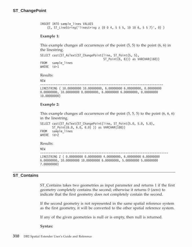
INSERT INTO sample_lines VALUES(2, ST_LineString(’linestring z (0 0 4, 5 5 5, 10 10 6, 5 5 7)’, 0) )
Example 1:
This example changes all occurrences of the point (5, 5) to the point (6, 6) inthe linestring.SELECT cast(ST_AsText(ST_ChangePoint(line, ST_Point(5, 5),
ST_Point(6, 6))) as VARCHAR(160))FROM sample_linesWHERE id=1
Results:NEW------------------------------------------------------------------------LINESTRING ( 10.00000000 10.00000000, 6.00000000 6.00000000, 0.000000000.00000000, 10.00000000 0.00000000, 6.00000000 6.00000000, 0.0000000010.00000000)
Example 2:
This example changes all occurrences of the point (5, 5, 5) to the point (6, 6, 6)in the linestring.SELECT cast(ST_AsText(ST_ChangePoint(line, ST_Point(5.0, 5.0, 5.0),
ST_Point(6.0, 6.0, 6.0) )) as VARCHAR(180))FROM sample_linesWHERE id=2
Results:NEW---------------------------------------------------------------------------LINESTRING Z ( 0.00000000 0.00000000 4.00000000, 6.00000000 6.000000006.00000000, 10.00000000 10.00000000 6.00000000, 5.00000000 5.000000007.00000000)
ST_Contains
ST_Contains takes two geometries as input parameter and returns 1 if the firstgeometry completely contains the second; otherwise it returns 0 (zero) toindicate that the first geometry does not completely contain the second.
If the second geometry is not represented in the same spatial reference systemas the first geometry, it will be converted to the other spatial reference system.
If any of the given geometries is null or is empty, then null is returned.
Syntax:
ST_ChangePoint
310 DB2 Spatial Extender User’s Guide and Reference

�� db2gse.ST_Contains ( geometry1 , geometry2 ) ��
Parameter:
geometry1A value of type ST_Geometry or one of its subtypes that representsthe geometry that is to be tested to completely contain geometry2.
geometry2A value of type ST_Geometry or one of its subtypes that representsthe geometry that is to be tested to be completely within geometry1.
Return type:
INTEGER
Examples:
The following code creates and populates these tables.SET CURRENT FUNCTION PATH = CURRENT FUNCTION PATH, db2gse
CREATE TABLE sample_points(id SMALLINT, geometry ST_POINT)
CREATE TABLE sample_lines(id SMALLINT, geometry ST_LINESTRING)
CREATE TABLE sample_polygons(id SMALLINT, geometry ST_POLYGON)
INSERT INTO sample_points (id, geometry)VALUES
(1, ST_Point(10, 20, 1)),(2, ST_Point(’point(41 41)’, 1))
INSERT INTO sample_lines (id, geometry)VALUES
(10, ST_LineString(’linestring (1 10, 3 12, 10 10)’, 1) ),(20, ST_LineString(’linestring (50 10, 50 12, 45 10)’, 1) )
INSERT INTO sample_polygons(id, geometry)VALUES
(100, ST_Polygon(’polygon((0 0, 0 40, 40 40, 40 0, 0 0))’, 1) )
Example 1:
The following code fragment uses the ST_Contains function to determinewhich points are contained by a particular polygon.SELECT poly.id AS polygon_id,
CASE ST_Contains(poly.geometry, pts.geometry)WHEN 0 THEN ’does not contain’WHEN 1 THEN ’does contain’
END AS contains,pts.id AS point_id
FROM sample_points pts, sample_polygons poly
ST_Contains
Chapter 19. Spatial functions: syntax and parameters 311

Results:POLYGON_ID CONTAINS POINT_ID---------- ---------------- --------
100 does contain 1100 does not contain 2
Example 2:
The following code fragment uses the ST_Contains function to determinewhich lines are contained by a particular polygon.SELECT poly.id AS polygon_id,
CASE ST_Contains(poly.geometry, line.geometry)WHEN 0 THEN ’does not contain’WHEN 1 THEN ’does contain
END AS contains,line.id AS line_id
FROM sample_lines line, sample_polygons poly
Results:POLYGON_ID CONTAINS LINE_ID---------- ---------------- -------
100 does contain 10100 does not contain 20
Related reference:
v “ST_Within” on page 478
ST_ConvexHull
ST_ConvexHull takes a geometry as an input parameter and returns theconvex hull of it.
The resulting geometry is represented in the spatial reference system of thegiven geometry.
If possible, the specific type of the returned geometry will be ST_Point,ST_LineString, or ST_Polygon. For example, the boundary of a polygon withno holes is a single linestring, represented as ST_LineString. The boundary ofa polygon with one or more holes consists of multiple linestrings, representedas ST_MultiLineString.
If the given geometry is null or is empty, then null is returned.
This function can also be called as a method.
Syntax:
ST_Contains
312 DB2 Spatial Extender User’s Guide and Reference
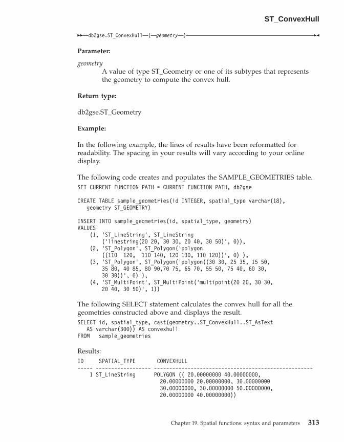
�� db2gse.ST_ConvexHull ( geometry ) ��
Parameter:
geometryA value of type ST_Geometry or one of its subtypes that representsthe geometry to compute the convex hull.
Return type:
db2gse.ST_Geometry
Example:
In the following example, the lines of results have been reformatted forreadability. The spacing in your results will vary according to your onlinedisplay.
The following code creates and populates the SAMPLE_GEOMETRIES table.SET CURRENT FUNCTION PATH = CURRENT FUNCTION PATH, db2gse
CREATE TABLE sample_geometries(id INTEGER, spatial_type varchar(18),geometry ST_GEOMETRY)
INSERT INTO sample_geometries(id, spatial_type, geometry)VALUES
(1, ’ST_LineString’, ST_LineString(’linestring(20 20, 30 30, 20 40, 30 50)’, 0)),
(2, ’ST_Polygon’, ST_Polygon(’polygon((110 120, 110 140, 120 130, 110 120))’, 0) ),
(3, ’ST_Polygon’, ST_Polygon(’polygon((30 30, 25 35, 15 50,35 80, 40 85, 80 90,70 75, 65 70, 55 50, 75 40, 60 30,30 30))’, 0) ),
(4, ’ST_MultiPoint’, ST_MultiPoint(’multipoint(20 20, 30 30,20 40, 30 50)’, 1))
The following SELECT statement calculates the convex hull for all thegeometries constructed above and displays the result.SELECT id, spatial_type, cast(geometry..ST_ConvexHull..ST_AsText
AS varchar(300)) AS convexhullFROM sample_geometries
Results:ID SPATIAL_TYPE CONVEXHULL----- ------------------ ----------------------------------------------------
1 ST_LineString POLYGON (( 20.00000000 40.00000000,20.00000000 20.00000000, 30.0000000030.00000000, 30.00000000 50.00000000,20.00000000 40.00000000))
ST_ConvexHull
Chapter 19. Spatial functions: syntax and parameters 313

2 ST_Polygon POLYGON (( 110.00000000 140.00000000,110.00000000 120.00000000, 120.00000000130.00000000, 110.00000000 140.00000000))
3 ST_Polygon POLYGON (( 15.00000000 50.00000000,25.00000000 35.00000000, 30.0000000030.00000000, 60.00000000 30.00000000,75.00000000 40.00000000, 80.0000000090.00000000, 40.00000000 85.00000000,35.00000000 80.00000000, 15.0000000050.00000000))
4 ST_MultiPoint POLYGON (( 20.00000000 40.00000000,20.00000000 20.00000000, 30.0000000030.00000000, 30.00000000 50.00000000,20.00000000 40.00000000))
ST_CoordDim
ST_CoordDim takes a geometry as an input parameter and returns thedimensionality of its coordinates.
If the given geometry does not have Z and M coordinates, the dimensionalityis 2. If it has Z coordinates and no M coordinates, or if it has M coordinatesand no Z coordinates, the dimensionality is 3. If it has Z and M coordinates,the dimensionality is 4. If the geometry is null, then null is returned.
This function can also be called as a method.
Syntax:
�� db2gse.ST_CoordDim ( geometry ) ��
Parameter:
geometryA value of type ST_Geometry or one of its subtypes that representsthe geometry to retrieve the dimensionality from.
Return type:
INTEGER
Example:
This example creates several geometries and then determines thedimensionality of their coordinates.
ST_ConvexHull
314 DB2 Spatial Extender User’s Guide and Reference
SET CURRENT FUNCTION PATH = CURRENT FUNCTION PATH, db2gseCREATE TABLE sample_geoms (id CHARACTER(15), geometry ST_Geometry)
INSERT INTO sample_geoms VALUES(’Empty Point’, ST_Geometry(’point EMPTY’,0))
INSERT INTO sample_geoms VALUES(’Linestring’, ST_Geometry(’linestring (10 10, 15 20)’,0))
INSERT INTO sample_geoms VALUES(’Polygon’, ST_Geometry(’polygon((40 120, 90 120, 90 150,
40 150, 40 120))’ ,0))
INSERT INTO sample_geoms VALUES(’Multipoint M’, ST_Geometry(’multipoint m (10 10 5, 50 10
6, 10 30 8)’ ,0))
INSERT INTO sample_geoms VALUES(’Multipoint Z’, ST_Geometry(’multipoint z (47 34 295,
23 45 678)’ ,0))
INSERT INTO sample_geoms VALUES(’Point ZM’, ST_Geometry(’point zm (10 10 16 30)’ ,0))
SELECT id, ST_CoordDim(geometry) COORDDIMFROM sample_geoms
Results:ID COORDDIM--------------- -----------Empty Point 2Linestring 2Polygon 2Multipoint M 3Multipoint Z 3Point ZM 4
ST_Crosses
ST_Crosses takes two geometries as input parameters and returns 1 if the firstgeometry crosses the second. Otherwise, 0 (zero) is returned.
If the second geometry is not represented in the same spatial reference systemas the first geometry, it will be converted to the other spatial reference system.
If the first geometry is a polygon or a multipolygon, or if the secondgeometry is a point or multipoint, or if any of the geometries is null value oris empty, then null is returned. If the intersection of the two geometries resultsin a geometry that has a dimension that is one less than the maximum
ST_CoordDim
Chapter 19. Spatial functions: syntax and parameters 315

dimension of the two given geometries, and if the resulting geometry is notequal any of the two given geometries, then 1 is returned. Otherwise, theresult is 0 (zero).
Syntax:
�� db2gse.ST_Crosses ( geometry1 , geometry2 ) ��
Parameter:
geometry1A value of type ST_Geometry or one of its subtypes that representsthe geometry that is to be tested for crossing geometry2.
geometry2A value of type ST_Geometry or one of its subtypes that representsthe geometry that is to be tested to determine if it is crossed bygeometry1.
Return Type:
INTEGER
Example:
This code determines if the constructed geometries cross each other.SET CURRENT FUNCTION PATH = CURRENT FUNCTION PATH, db2gseCREATE TABLE sample_geoms (id INTEGER, geometry ST_Geometry)
INSERT INTO sample_geoms VALUES(1, ST_Geometry(’polygon((30 30, 30 50, 50 50, 50 30, 30 30))’ ,0))
INSERT INTO sample_geoms VALUES(2, ST_Geometry(’linestring(40 50, 50 40)’ ,0))
INSERT INTO sample_geoms VALUES(3, ST_Geometry(’linestring(20 20, 60 60)’ ,0))
SELECT a.id, b.id, ST_Crosses(a.geometry, b.geometry) CrossesFROM sample_geoms a, sample_geoms b
Results:ID ID CROSSES----------- ----------- -----------
1 1 -2 1 03 1 11 2 -2 2 03 2 1
ST_Crosses
316 DB2 Spatial Extender User’s Guide and Reference

1 3 -2 3 13 3 0
Related reference:
v “Functions that make comparisons” on page 252
ST_Difference
ST_Difference takes two geometries as input parameters and returns thegeometry that is the difference of the given geometries. The difference of thetwo geometries is that part of the first geometry that does not overlap withthe second geometry.
If the second geometry is not represented in the same spatial reference systemas the first geometry, it will be converted to the other spatial reference system.
If any of the two given geometries is null, or if the two given geometries arenot of the same dimension, then null is returned. If the first geometry isempty, an empty geometry of type ST_Point is returned. If the secondgeometry is empty, then the first geometry is returned unchanged.
If possible, the specific type of the returned geometry will be ST_Point,ST_LineString, or ST_Polygon. For example, the boundary of a polygon withno holes is a single linestring, represented as ST_LineString. The boundary ofa polygon with one or more holes consists of multiple linestrings, representedas ST_MultiLineString.
This function can also be called as a method.
Syntax:
�� db2gse.ST_Difference ( geometry1 , geometry2 ) ��
Parameter:
geometry1A value of type ST_Geometry that represents the first geometry to useto compute the difference to geometry2.
geometry2A value of type ST_Geometry that represents the second geometrythat is used to compute the difference to geometry1.
ST_Crosses
Chapter 19. Spatial functions: syntax and parameters 317

Return type:
db2gse.ST_Geometry
Examples:
In the following example, the lines of results have been reformatted forreadability. The spacing in your results will vary according to your onlinedisplay.
The following code creates and populates the SAMPLE_GEOMETRIES table.SET CURRENT FUNCTION PATH = CURRENT FUNCTION PATH, db2gseCREATE TABLE sample_geoms (id INTEGER, geometry ST_Geometry)
INSERT INTO sample_geoms VALUES(1, ST_Geometry(’polygon((10 10, 10 20, 20 20, 20 10, 10 10))’ ,0))
INSERT INTO sample_geoms VALUES(2, ST_Geometry(’polygon((30 30, 30 50, 50 50, 50 30, 30 30))’ ,0))
INSERT INTO sample_geoms VALUES(3, ST_Geometry(’polygon((40 40, 40 60, 60 60, 60 40, 40 40))’ ,0))
INSERT INTO sample_geoms VALUES(4, ST_Geometry(’linestring(70 70, 80 80)’ ,0))
INSERT INTO sample_geoms VALUES(5, ST_Geometry(’linestring(75 75, 90 90)’ ,0))
Example 1:
This example finds the difference between two disjoint polygons.SELECT a.id, b.id, CAST(ST_AsText(ST_Difference(a.geometry, b.geometry))
as VARCHAR(200)) DifferenceFROM sample_geoms a, sample_geoms bWHERE a.id = 1 and b.id = 2
Results:ID ID DIFFERENCE-------- -------- ----------------------------------------------------
1 2 POLYGON (( 10.00000000 10.00000000, 20.0000000010.00000000, 20.00000000 20.00000000,10.00000000 20.00000000, 10.00000000 10.00000000))
Example 2:
This example finds the difference between two intersecting polygons.SELECT a.id, b.id, CAST(ST_AsText(ST_Difference(a.geometry, b.geometry))
as VARCHAR(200)) DifferenceFROM sample_geoms a, sample_geoms bWHERE a.id = 2 and b.id = 3
ST_Difference
318 DB2 Spatial Extender User’s Guide and Reference
Results:ID ID DIFFERENCE-------- -------- ---------------------------------------------------
2 3 POLYGON (( 30.00000000 30.00000000, 50.0000000030.00000000, 50.00000000 40.00000000, 40.0000000040.00000000, 40.00000000 50.00000000, 30.0000000050.00000000, 30.00000000 30.00000000))
Example 3:
This example finds the difference between two overlapping linestrings.SELECT a.id, b.id, CAST(ST_AsText(ST_Difference(a.geometry, b.geometry))
as VARCHAR(100)) DifferenceFROM sample_geoms a, sample_geoms bWHERE a.id = 4 and b.id = 5
Results:ID ID DIFFERENCE-------- -------- --------------------------------------------------
4 5 LINESTRING ( 70.00000000 70.00000000, 75.0000000075.00000000)
ST_Dimension
ST_Dimension takes a geometry as an input parameter and returns itsdimension.
If the given geometry is empty, then -1 is returned. For points andmultipoints, the dimension is 0 (zero); for curves and multicurves, thedimension is 1; and for polygons and multipolygons, the dimension is 2. If thegiven geometry is null, then null is returned.
This function can also be called as a method.
Syntax:
�� db2gse.ST_Dimension ( geometry ) ��
Parameter:
geometryA value of type ST_Geometry that represents the geometry for whichthe dimension is returned.
Return type:
INTEGER
ST_Difference
Chapter 19. Spatial functions: syntax and parameters 319

Example:
This example creates several different geometries and finds their dimensions.SET CURRENT FUNCTION PATH = CURRENT FUNCTION PATH, db2gseCREATE TABLE sample_geoms (id char(15), geometry ST_Geometry)
INSERT INTO sample_geoms VALUES(’Empty Point’, ST_Geometry(’point EMPTY’,0))
INSERT INTO sample_geoms VALUES(’Point ZM’, ST_Geometry(’point zm (10 10 16 30)’ ,0))
INSERT INTO sample_geoms VALUES(’MultiPoint M’, ST_Geometry(’multipoint m (10 10 5,50 10 6, 10 30 8)’ ,0))
INSERT INTO sample_geoms VALUES(’LineString’, ST_Geometry(’linestring (10 10, 15 20)’,0))
INSERT INTO sample_geoms VALUES(’Polygon’, ST_Geometry(’polygon((40 120, 90 120, 90 150,40 150, 40 120))’ ,0))
SELECT id, ST_Dimension(geometry) DimensionFROM sample_geoms
Results:ID DIMENSION--------------- -----------Empty Point -1Point ZM 0MultiPoint M 0LineString 1Polygon 2
ST_Disjoint
ST_Disjoint takes two geometries as input parameters and returns 1 if thegiven geometries do not intersect. If the geometries do intersect, then 0 (zero)is returned.
If the second geometry is not represented in the same spatial reference systemas the first geometry, it will be converted to the other spatial reference system.
If any of the two geometries is null or is empty, then null value is returned.
This function can also be called as a method.
Syntax:
ST_Dimension
320 DB2 Spatial Extender User’s Guide and Reference
�� db2gse.ST_Disjoint ( geometry1 , geometry2 ) ��
Parameter:
geometry1A value of type ST_Geometry that represents the geometry that istested to be disjoint with geometry2.
geometry2A value of type ST_Geometry that represents the geometry that that istested to be disjoint with geometry1.
Return type:
INTEGER
Examples:
This code creates several geometries in the SAMPLE_GEOMETRIES table.SET CURRENT FUNCTION PATH = CURRENT FUNCTION PATH, db2gseCREATE TABLE sample_geoms (id INTEGER, geometry ST_Geometry)
INSERT INTO sample_geoms VALUES(1, ST_Geometry(’polygon((20 30, 30 30, 30 40, 20 40, 20 30))’,0))
INSERT INTO sample_geoms VALUES(2, ST_Geometry(’polygon((30 30, 30 50, 50 50, 50 30, 30 30))’,0))
INSERT INTO sample_geoms VALUES(3, ST_Geometry(’polygon((40 40, 40 60, 60 60, 60 40, 40 40))’,0))
INSERT INTO sample_geoms VALUES(4, ST_Geometry(’linestring(60 60, 70 70)’ ,0))
INSERT INTO sample_geoms VALUES(5, ST_Geometry(’linestring(30 30, 40 40)’ ,0))
Example 1:
This example determines if the first polygon is disjoint from any of thegeometries.SELECT a.id, b.id, ST_Disjoint(a.geometry, b.geometry) DisJointFROM sample_geoms a, sample_geoms bWHERE a.id = 1
Results:ID ID DISJOINT----------- ----------- -----------
1 1 0
ST_Disjoint
Chapter 19. Spatial functions: syntax and parameters 321
1 2 01 3 11 4 11 5 0
Example 2:
This example determines if the third polygon is disjoint from any of thegeometries.SELECT a.id, b.id, ST_Disjoint(a.geometry, b.geometry) DisJointFROM sample_geoms a, sample_geoms bWHERE a.id = 3
Results:ID ID DISJOINT----------- ----------- -----------
3 1 13 2 03 3 03 4 03 5 0
Example 3:
This example determines if the second linestring is disjoint from any of thegeometries.SELECT a.id, b.id, ST_Disjoint(a.geometry, b.geometry) DisJointFROM sample_geoms a, sample_geoms bWHERE a.id = 5
Results:ID ID DISJOINT----------- ----------- -----------
5 1 05 2 05 3 05 4 15 5 0
Related reference:
v “Functions that make comparisons” on page 252
ST_Edge_GC_USA
ST_Edge_GC_USA is the function that implements theDB2SE_USA_GEOCODER which geocodes addresses located in the UnitedStates of America into points. The addresses are compared (matched) againstEDGE files, which are provided on the geocoder data CD.
ST_Disjoint
322 DB2 Spatial Extender User’s Guide and Reference

The function takes the street number and name, the city name, the state, thezip code, and the spatial reference system identifier for the resulting point asinput parameters and returns an ST_Point value. Additionally, severalconfiguration parameters that influence the geocoding process can bespecified.
Syntax:
�� db2gse.ST_Edge_GC_USA ( street , city , state , zip , srs_id , �
� spelling_sens , min_match_score , side_offset , side_offset_units , end_offset , �
� base_map , locator_file ) ��
Parameter:
street A value of type VARCHAR(128) that contains the street number andname of the address to be geocoded.
This value must not be null.
city A value of type VARCHAR(128) that contains the name of the city ofthe address to be geocoded.
This value can be null if the zip parameter is specified.
state A value of type VARCHAR(128) that contains the name of the state ofthe address to be geocoded. The state can be abbreviated or spelledout.
This value can be null if the zip parameter is specified.
zip A value of type VARCHAR(10) that contains the zip code of theaddress to be geocoded. The zip code can be given as 5 digits or inthe 5+4 notation.
This value can be null if the city and state parameters are specified.
srs_id A value of type INTEGER that contains the numeric identifier of thespatial reference system for the resulting point. The value mustidentify an existing spatial reference system, that uses a projectedcoordinate system based on the geographic coordinate systemGCS_NORTH_AMERICAN_1983, or an existing spatial referencesystem that uses the geographic coordinate system itself,GCS_NORTH_AMERICAN_1983.
If srs_id does not identify a spatial reference system listed in thecatalog view DB2GSE.ST_SPATIAL_REFERENCE_SYSTEMS, then anerror is returned (SQLSTATE 38SU1).
spelling_sensA value of type INTEGER that specifies the spelling sensitivity thatshould be applied to the given address. The value must be in therange from 0 (zero) to 100. The higher this value is, the more strict the
ST_Edge_GC_USA
Chapter 19. Spatial functions: syntax and parameters 323

geocoder will be regarding differences in the spelling of the givenaddress. Deviations result in a higher penalty that will be applied tothe final score of the match.
If the spelling sensitivity is set too high, fewer addresses might begeocoded successfully, and a null will be returned instead. If it thespelling sensitivity is set too low, a more unmatching addresses mightbe considered correct matches due to the accepted level of differencein the spelling of the addresses. Recommendation: Set this value to60.
If this value is null, the spelling sensitivity will be derived from thelocatior file. If it is not specified in the locator file, a spellingsensitivity of 60 is used.
min_match_scoreA value of type INTEGER that contains the minimum score value thata point must have to be considered a match for the given address. Theminimum score value must be in the range from 0 (zero) to 100. If thescore of the point is lower than the min_match_score value, null isreturned instead of the point, and the address is not geocoded.
Different factors like the quality of the base map, the spellingsensitivity, or the accuracy if the address influence the score of apoint. Recommendation: Set this value to 80.
If this value is null, the minimum match score will be derived fromthe locator file. If it is not specified in the locator file, a minimumscore value of 80 is used.
side_offsetA value of type DOUBLE that specifies how far a resulting point is tobe placed off the center of the street. The value must be larger than orequal to 0 (zero). The side_offset_unit parameter identifies the unitsthat are used to measure the side offset.
If this value is null, the side offset will be derived from the locatorfile. If it is not specified in the locator file, a side offset of 0.0 is used.
side_offset_unitsA value of type VARCHAR(128) that contains the units in which theside_offset parameter is measured. The value must be one of thefollowing units:v Inchesv Pointsv Feetv Yardsv Miles
ST_Edge_GC_USA
324 DB2 Spatial Extender User’s Guide and Reference

v Nautical milesv Millimetersv Centimetersv Metersv Kilometersv Decimal degreesv Projected metersv Reference data units
If this value is null, the side offset units will be derived from thelocator file. If it is not specified in the locator file, the side offset willbe measured in feet.
end_offsetA value of type INTEGER that indicates how far a point that wouldbe exactly at the end of a street segment should be placed in thesegment instead. The value must be larger than or equal to 0 (zero).This parameter is used to avoid placing resulting points in the middleof a street at intersections. The end offset is measured in points (thesmallest possible resolution) on the base map.
If this value is null, the end offset will be derived from the locator file.If it is not specified in the locator file, an end offset of 3 is used.
base_mapA value of type VARCHAR(256) that contains the fully qualified path,including the base name, to the base map (.edg) file. The base mapfile is used by the geocoder to match the given addresses against. Thebase maps supplied by the DB2 Spatial Extender should be used. Youcan use this parameter if you placed the base maps in a differentdirectory.
If this value is null, the path to the base map will be derived from thelocator file. If it is not specified in the locator file, the base map willbe searched for in the sqllib directory of the current instance, in thegse/refdata subdirectory. The base name of the file searched for isusa.edg.
locator_fileA value of type VARCHAR(256) that contains the fully qualified path,including the base name, to the locator file that contains additionalconfiguration parameters for the geocoder. The locator file supplied bythe DB2 Spatial Extender should be used.
ST_Edge_GC_USA
Chapter 19. Spatial functions: syntax and parameters 325
If this value is null, the locator file will be searched for in the sqllibdirectory of the current instance, in the gse/cfg/geocodersubdirectory. The base name of the file searched for isEDGELocator.loc.
Return type:
db2gse.ST_Point
Examples:
Example 1:
The following code creates a table SAMPLE_GEOCODING and inserts twoaddresses that are subsequently geocoded. The minimum match score will beset to 50 for the given addresses, and the spatial reference system for theresulting points is 1.SET CURRENT FUNCTION PATH = CURRENT FUNCTION PATH, db2gse
CREATE TABLE sample_geocoding (street VARCHAR(128),city VARCHAR(128),state VARCHAR(128),zip VARCHAR(5) )
INSERT INTO geocoding(street, city, state, zip)VALUES (’1212 New York Ave NW’, ’Washington’, ’DC’, ’20005’),(’100 First North Street’, ’San Jose’, ’CA’, NULL)
SELECT VARCHAR(ST_AsText(ST_Edge_GC_USA(street, city, state, zip, 1,CAST(NULL AS INTEGER), 50, CAST(NULL AS DOUBLE),CAST(NULL AS VARCHAR(128)), CAST(NULL AS INTEGER),CAST(NULL AS VARCHAR(256)), CAST(NULL AS VARCHAR(256)))), 50)
FROM sample_geocoding
Results:1--------------------------------------------------POINT ( -77.02829300 38.90049000)POINT ( -121.94507200 37.28766700)
Example 2:
In this example, a spatial reference system is created that uses a projectedcoordinate system. To simplify the interface of the geocoding function, auser-defined function is created to wrap the ST_Edge_GC_USA function.db2se create_srs <db_name> -srsName CALIFORNIA -srsId 101 -xScale 1
-coordsysName NAD_1983_STATEPLANE_CALIFORNIA_I_FIPS_0401
ST_Edge_GC_USA
326 DB2 Spatial Extender User’s Guide and Reference

SET CURRENT FUNCTION PATH = CURRENT FUNCTION PATH, db2gse
CREATE FUNCTION California_GC (street VARCHAR(128), city VARCHAR(128), zip VARCHAR(10))RETURNS db2gse.ST_Point
LANGUAGE SQLRETURN db2gse.ST_Edge_GC_USA(street, city, ’CA’, zip, 101,
CAST(NULL AS INTEGER), CAST(NULL AS INTEGER),CAST(NULL AS DOUBLE), CAST(NULL AS VARCHAR(128)),
CAST(NULL AS INTEGER), CAST(NULL AS VARCHAR(256)))
CREATE TABLE sample_geocoding (street VARCHAR(128),city VARCHAR(128),state VARCHAR(128),
zip VARCHAR(5) )
INSERT INTO geocoding(street, city, state, zip)VALUES (’100 First North Street’, ’San Jose’, ’CA’, NULL)
SELECT VARCHAR(ST_AsText(California_GC(street, city, zip)), 50)FROM sample_geocoding
Results:1--------------------------------------------------POINT ( 2004879.00000000 272723.00000000)
NetBIOS
Note: The values of the X and Y coordinates of the point are different than inthe first example because a different spatial reference system is used.
ST_Distance
ST_Distance takes two geometries and, optionally, a unit as input parametersand returns the shortest distance between any point in the first geometry toany point in the second geometry, measured in the given units.
If the second geometry is not represented in the same spatial reference systemas the first geometry, it will be converted to the other spatial reference system.
If any of the two given geometries is null or is empty, then null is returned.
This function can also be called as a method.
Syntax:
ST_Edge_GC_USA
Chapter 19. Spatial functions: syntax and parameters 327
�� db2gse.ST_Distance ( geometry1 , geometry2 ), unit
��
Parameter:
geometry1A value of type ST_Geometry that represents the geometry that isused to compute the distance to geometry2.
geometry2A value of type ST_Geometry that represents the geometry that isused to compute the distance to geometry1.
unit VARCHAR(128) value that identifies the unit in which the result ismeasured. The supported units of measure are listed in theDB2GSE.ST_UNITS_OF_MEASURE catalog view.
If the unit parameter is omitted, the following rules are used to determine theunit of measure used for the result:v If geometry1 is in a projected or geocentric coordinate system, the linear unit
associated with this coordinate system is used.v If geometry1 is in a geographic coordinate system, the angular unit
associated with this coordinate system is used.
If geometry1 is in an unspecified coordinate system and the unit parameter isspecified, or if geometry1 is in a geographic coordinate system and a linearunit is specified, then an error is returned (SQLSTATE 38SU4).
Return type:
DOUBLE
Examples:
The following code creates and populates the SAMPLE_GEOMETRIES1 andSAMPLE_GEOMETRIES2 tables.SET CURRENT FUNCTION PATH = CURRENT FUNCTION PATH, db2gse
CREATE TABLE sample_geometries1(id SMALLINT, spatial_type varchar(13),geometry ST_GEOMETRY)
CREATE TABLE sample_geometries2(id SMALLINT, spatial_type varchar(13),geometry ST_GEOMETRY)
INSERT INTO sample_geometries1(id, spatial_type, geometry)VALUES
( 1, ’ST_Point’, ST_Point(’point(100 100)’, 1) ),(10, ’ST_LineString’, ST_LineString(’linestring(125 125, 125 175)’, 1) ),(20, ’ST_Polygon’, ST_Polygon(’polygon
ST_Distance
328 DB2 Spatial Extender User’s Guide and Reference

((50 50, 50 150, 150 150, 150 50, 50 50))’, 1) )
INSERT INTO sample_geometries2(id, spatial_type, geometry)VALUES
(101, ’ST_Point’, ST_Point(’point(200 200)’, 1) ),(102, ’ST_Point’, ST_Point(’point(200 300)’, 1) ),(103, ’ST_Point’, ST_Point(’point(200 0)’, 1) ),(110, ’ST_LineString’, ST_LineString(’linestring(200 100, 200 200)’, 1) ),(120, ’ST_Polygon’, ST_Polygon(’polygon
((200 0, 200 200, 300 200, 300 0, 200 0))’, 1) )
Example 1:
The following SELECT statement calculates the distance between the variousgeometries in the SAMPLE_GEOMTRIES1 and SAMPLE_GEOMTRIES2 tables..SELECT sg1.id AS sg1_id, sg1.spatial_type AS sg1_type,
sg2.id AS sg1_id, sg2.spatial_type AS sg2_type,cast(ST_Distance(sg1.geometry, sg2.geometry)AS Decimal(8, 4)) AS distance
FROM sample_geometries1 sg1, sample_geometries2 sg2ORDER BY sg1.id
Results:SG1_ID SG1_TYPE SG1_ID SG2_TYPE DISTANCE------ ------------- ------ ------------- ----------
1 ST_Point 101 ST_Point 141.42131 ST_Point 102 ST_Point 223.60671 ST_Point 103 ST_Point 141.42131 ST_Point 110 ST_LineString 100.00001 ST_Point 120 ST_Polygon 100.000010 ST_LineString 101 ST_Point 79.056910 ST_LineString 102 ST_Point 145.773710 ST_LineString 103 ST_Point 145.773710 ST_LineString 110 ST_LineString 75.000010 ST_LineString 120 ST_Polygon 75.000020 ST_Polygon 101 ST_Point 70.710620 ST_Polygon 102 ST_Point 158.113820 ST_Polygon 103 ST_Point 70.710620 ST_Polygon 110 ST_LineString 50.000020 ST_Polygon 120 ST_Polygon 50.0000
Example 2:
The following SELECT statement illustrates how to find all the geometriesthat are within a distance of 100 of each other.SELECT sg1.id AS sg1_id, sg1.spatial_type AS sg1_type,
sg2.id AS sg1_id, sg2.spatial_type AS sg2_type,cast(ST_Distance(sg1.geometry, sg2.geometry)
ST_Distance
Chapter 19. Spatial functions: syntax and parameters 329

AS Decimal(8, 4)) AS distanceFROM sample_geometries1 sg1, sample_geometries2 sg2WHERE ST_Distance(sg1.geometry, sg2.geometry) <= 100
Results:SG1_ID SG1_TYPE SG1_ID SG2_TYPE DISTANCE------ ------------- ------ ------------- ----------
1 ST_Point 110 ST_LineString 100.00001 ST_Point 120 ST_Polygon 100.000010 ST_LineString 101 ST_Point 79.056910 ST_LineString 110 ST_LineString 75.000010 ST_LineString 120 ST_Polygon 75.000020 ST_Polygon 101 ST_Point 70.710620 ST_Polygon 103 ST_Point 70.710620 ST_Polygon 110 ST_LineString 50.000020 ST_Polygon 120 ST_Polygon 50.0000
Example 3:
The following SELECT statement calculates the distance in kilometers betweenthe various geometries.SAMPLE_GEOMTRIES1 and SAMPLE_GEOMTRIES2 tables.SELECT sg1.id AS sg1_id, sg1.spatial_type AS sg1_type,
sg2.id AS sg1_id, sg2.spatial_type AS sg2_type,cast(ST_Distance(sg1.geometry, sg2.geometry, ’KILOMETER’)AS DECIMAL(10, 4)) AS distance
FROM sample_geometries1 sg1, sample_geometries2 sg2ORDER BY sg1.id
Results:SG1_ID SG1_TYPE SG1_ID SG2_TYPE DISTANCE------ ------------- ------ ------------- ------------
1 ST_Point 101 ST_Point 12373.21681 ST_Point 102 ST_Point 16311.38161 ST_Point 103 ST_Point 9809.47131 ST_Point 110 ST_LineString 1707.44631 ST_Point 120 ST_Polygon 12373.216810 ST_LineString 101 ST_Point 8648.233310 ST_LineString 102 ST_Point 11317.393410 ST_LineString 103 ST_Point 10959.731310 ST_LineString 110 ST_LineString 3753.586210 ST_LineString 120 ST_Polygon 10891.125420 ST_Polygon 101 ST_Point 7700.533320 ST_Polygon 102 ST_Point 15039.810920 ST_Polygon 103 ST_Point 7284.855220 ST_Polygon 110 ST_LineString 6001.840720 ST_Polygon 120 ST_Polygon 14515.8872
Related reference:
v “Functions that make comparisons” on page 252
ST_Distance
330 DB2 Spatial Extender User’s Guide and Reference

ST_Endpoint
ST_Endpoint takes a curve as an input parameter and returns the point that isthe last point of the curve. The resulting point is represented in the spatialreference system of the given curve.
If the given curve is null or is empty, then null is returned.
This function can also be called as a method.
Syntax:
�� db2gse.ST_EndPoint ( curve ) ��
Parameter:
curve A value of type ST_Curve that represents the geometry from whichthe last point is returned.
Return type:
db2gse.ST_Point
Example:
The SELECT statement finds the endpoint of each of the geometries in theSAMPLE_LINES table.SET CURRENT FUNCTION PATH = CURRENT FUNCTION PATH, db2gseCREATE TABLE sample_lines(id INTEGER, line ST_Linestring)
INSERT INTO sample_lines VALUES(1, ST_LineString(’linestring (10 10, 5 5, 0 0, 10 0, 5 5, 0 10)’, 0) )
INSERT INTO sample_lines VALUES(2, ST_LineString(’linestring z (0 0 4, 5 5 5, 10 10 6, 5 5 7)’, 0) )
SELECT id, CAST(ST_AsText(ST_EndPoint(line)) as VARCHAR(50)) EndpointFROM sample_lines
Results:ID ENDPOINT----------- --------------------------------------------------
1 POINT ( 0.00000000 10.00000000)2 POINT Z ( 5.00000000 5.00000000 7.00000000)
ST_Endpoint
Chapter 19. Spatial functions: syntax and parameters 331

Related reference:
v “ST_PointN” on page 443
ST_Envelope
ST_Envelope takes a geometry as an input parameter and returns an envelopearound the geometry. The envelope is a rectangle that is represented as apolygon.
If the given geometry is a point, a horizontal linestring, or a verticallinestring, then a rectangle, which is slightly larger than the given geometry, isreturned. Otherwise, the minimum bounding rectangle of the geometry isreturned as the envelope. If the given geometry is null or is empty, then nullis returned. To return the exact minimum bounding rectangle for allgeometries, use the function ST_MBR.
This function can also be called as a method.
Syntax:
�� db2gse.ST_Envelope ( geometry ) ��
Parameter:
geometryA value of type ST_Geometry that represents the geometry to returnthe envelope for.
Return type:
db2gse.ST_Polygon
Example:
In the following examples, the lines of results have been reformatted forreadability. The spacing in your results will vary according to your onlinedisplay.
This example creates several geometries and then determines their envelopes.For the non-empty point and the linestring (which is horizontal), the envelopeis a rectangle that is slightly larger than the geometry.SET CURRENT FUNCTION PATH = CURRENT FUNCTION PATH, db2gseCREATE TABLE sample_geoms (id INTEGER, geometry ST_Geometry)
INSERT INTO sample_geoms VALUES(1, ST_Geometry(’point EMPTY’,0))
ST_Endpoint
332 DB2 Spatial Extender User’s Guide and Reference

INSERT INTO sample_geoms VALUES(2, ST_Geometry(’point zm (10 10 16 30)’ ,0))
INSERT INTO sample_geoms VALUES(3, ST_Geometry(’multipoint m (10 10 5, 50 10 6, 10 30 8)’ ,0))
INSERT INTO sample_geoms VALUES(4, ST_Geometry(’linestring (10 10, 20 10)’,0))
INSERT INTO sample_geoms VALUES(5, ST_Geometry(’polygon((40 120, 90 120, 90 150, 40 150, 40 120))’,0))
SELECT id, CAST(ST_AsText(ST_Envelope(geometry)) as VARCHAR(160)) EnvelopeFROM sample_geoms
Results:ID ENVELOPE----------- ---------------------------------------------------------------
1 -
2 POLYGON (( 9.00000000 9.00000000, 11.00000000 9.00000000,11.00000000 11.00000000, 9.00000000 11.00000000, 9.00000000 9.00000000))
3 POLYGON (( 10.00000000 10.00000000, 50.00000000 10.00000000,50.00000000 30.00000000, 10.00000000 30.00000000, 10.0000000010.00000000))
4 POLYGON (( 10.00000000 9.00000000, 20.00000000 9.00000000,20.00000000 11.00000000, 10.00000000 11.00000000, 10.000000009.00000000))
5 POLYGON (( 40.00000000 120.00000000, 90.00000000 120.00000000,90.00000000 150.00000000, 40.00000000 150.00000000, 40.00000000120.00000000))
Related reference:
v “ST_MBR” on page 393
ST_EnvIntersects
ST_EnvIntersects takes two geometries as input parameters and returns 1 ifthe envelopes of two geometries intersect. Otherwise, 0 (zero) is returned.
If the second geometry is not represented in the same spatial reference systemas the first geometry, it will be converted to the other spatial reference system.
If any of the given geometries is null or is empty, then null value is returned.
ST_Envelope
Chapter 19. Spatial functions: syntax and parameters 333

Syntax:
�� db2gse.ST_EnvIntersect ( geometry1 , geometry2 ) ��
Parameter:
geometry1A value of type ST_Geometry or one of its subtypes that representsthe geometry whose envelope is to be tested for intersection with theenvelope of geometry2.
geometry2A value of type ST_Geometry or one of its subtypes that representsthe geometry whose envelope is to be tested for intersection with theenvelope of geometry1.
Return type:
INTEGER
Example:
This example creates two parallel linestrings and checks them for intersection.The linestrings themselves do not intersect, but the envelopes for them do.SET CURRENT FUNCTION PATH = CURRENT FUNCTION PATH, db2gseCREATE TABLE sample_geoms (id INTEGER, geometry ST_Geometry)
INSERT INTO sample_geoms VALUES(1, ST_Geometry(’linestring (10 10, 50 50)’,0))
INSERT INTO sample_geoms VALUES(2, ST_Geometry(’linestring (10 20, 50 60)’,0))
SELECT a.id, b.id, ST_Intersects(a.geometry, b.geometry) Intersects,ST_EnvIntersects(a.geometry, b.geometry) Envelope_Intersects
FROM sample_geoms a , sample_geoms bWHERE a.id = 1 and b.id=2
Results:ID ID INTERSECTS ENVELOPE_INTERSECTS----------- ----------- ----------- -------------------
1 2 0 1
ST_EnvIntersects
334 DB2 Spatial Extender User’s Guide and Reference

ST_EqualCoordsys
ST_EqualCoordsys takes two coordinate system definitions as inputparameters and returns the integer value 1 (one) if the given definitions areidentical. Otherwise, the integer value 0 (zero) is returned. The coordinatesystem definitions are compared regardless of differences in spaces,parenthesis, uppercase and lowercase characters, and the representation offloating point numbers.
If any of the given coordinate system definitions is null, null is returned.
Syntax:
�� db2gse.ST_EqualCoordsys ( coordinate_system1 , coordinate_system2 ) ��
Parameter:
coordinate_system1A value of type VARCHAR(2048) that defines the first coordinatesystem to be compared with coordinate_system2.
coordinate_system2A value of type VARCHAR(2048) that defines the second coordinatesystem to be compared with coordinate_system1.
Return type:
INTEGER
Example:
This example compares two Australian coordinate systems to see if they arethe same.SET CURRENT FUNCTION PATH = CURRENT FUNCTION PATH, db2gse
VALUES ST_EqualCoordSys((SELECT definitionFROM db2gse.ST_COORDINATE_SYSTEMSWHERE coordsys_name=’GCS_AUSTRALIAN’) ,
(SELECT definitionFROM db2gse.ST_COORDINATE_SYSTEMSWHERE coordsys_name=’GCS_AUSTRALIAN_1984’))
Results:
ST_EqualCoordsys
Chapter 19. Spatial functions: syntax and parameters 335

1-----------
0
Related reference:
v “The DB2GSE.ST_COORDINATE_SYSTEMS catalog view” on page 229
ST_Equals
ST_Equals takes two geometries as input parameters and returns 1 if thegeometries are equal. Otherwise 0 (zero) is returned. The order of the pointsused to define the geometry is not relevant for the test for equality.
If the second geometry is not represented in the same spatial reference systemas the first geometry, it will be converted to the other spatial reference system.
If any of the two given geometries is null, then null is returned.
Syntax:
�� db2gse.ST_Equals ( geometry1 , geometry2 ) ��
Parameter:
geometry1A value of type ST_Geometry that represents the geometry that is tobe compared with geometry2.
geometry2A value of type ST_Geometry that represents the geometry that is tobe compared with geometry1.
Return type:
INTEGER
Examples:
Example 1:
This example creates two polygons that have their coordinates in a differentorder. ST_Equal is used to show that these polygons are considered equal.SET CURRENT FUNCTION PATH = CURRENT FUNCTION PATH, db2gseCREATE TABLE sample_geoms (id INTEGER, geometry ST_Geometry)
INSERT INTO sample_geoms VALUES
ST_EqualCoordsys
336 DB2 Spatial Extender User’s Guide and Reference

(1, ST_Geometry(’polygon((50 30, 30 30, 30 50, 50 50, 50 30))’ ,0))
INSERT INTO sample_geoms VALUES(2, ST_Geometry(’polygon((50 30, 50 50, 30 50, 30 30, 50 30))’ ,0))
SELECT a.id, b.id, ST_Equals(a.geometry, b.geometry) EqualsFROM sample_geoms a, sample_geoms bWHERE a.id = 1 and b.id = 2
Results:ID ID EQUALS----------- ----------- -----------
1 2 1
Example 2:
In this example, two geometries are created with the same X and Ycoordinates, but different M coordinates (measures). When the geometries arecompared with the ST_Equal function, a 0 (zero) is returned to indicate thatthese geometries are not equal.SET CURRENT FUNCTION PATH = CURRENT FUNCTION PATH, db2gseCREATE TABLE sample_geoms (id INTEGER, geometry ST_Geometry)
INSERT INTO sample_geoms VALUES(3, ST_Geometry(’multipoint m(80 80 6, 90 90 7)’ ,0))
INSERT INTO sample_geoms VALUES(4, ST_Geometry(’multipoint m(80 80 6, 90 90 4)’ ,0))
SELECT a.id, b.id, ST_Equals(a.geometry, b.geometry) EqualsFROM sample_geoms a, sample_geoms bWHERE a.id = 3 and b.id = 4
Results:ID ID EQUALS----------- ----------- -----------
3 4 0
Example 3:
In this example, two geometries are created with a different set of coordinates,but both represent the same geometry. ST_Equal compares the geometries andindicates that both geometries are indeed equal.SET current function path = current function path, db2gseCREATE TABLE sample_geoms ( id INTEGER, geometry ST_Geometry )
INSERT INTO sample_geoms VALUES
ST_Equals
Chapter 19. Spatial functions: syntax and parameters 337
(5, ST_LineString(’linestring ( 10 10, 40 40 )’, 0)),(6, ST_LineString(’linestring ( 10 10, 20 20, 40 40)’, 0))
SELECT a.id, b.id, ST_Equals(a.geometry, b.geometry) EqualsFROM sample_geoms a, sample_geoms bWHERE a.id = 5 AND b.id = 6
Results:ID ID EQUALS----------- ----------- -----------
5 6 1
Related reference:
v “Functions that make comparisons” on page 252
ST_EqualSRS
ST_EqualSRS takes two spatial reference system identifiers as inputparameters and returns 1 if the given spatial reference systems are identical.Otherwise, 0 (zero) is returned. The offsets, scale factors, and the coordinatesystems are compared.
If any of the given spatial reference system identifiers is null, null is returned.
Syntax:
�� db2gse.ST_EqualSRS ( srs_id1 , srs_id2 ) ��
Parameter:
srs_id1 A value of type INTEGER that identifies the first spatial referencesystem to be compared with the spatial reference system identified bysrs_id2.
srs_id2 A value of type INTEGER that identifies the second spatial referencesystem to be compared with the spatial reference system identified bysrs_id1.
Return type:
INTEGER
Example:
Two similar spatial reference systems are created with the following calls todb2se.
ST_Equals
338 DB2 Spatial Extender User’s Guide and Reference
db2se create_srs SAMP_DB -srsId 12 -srsName NYE_12 -xOffset 0 -yOffset 0-xScale 1 -yScale 1 -coordsysNameNAD_1983_StatePlane_New_York_East_FIPS_3101_Feet
db2se create_srs SAMP_DB -srsId 22 -srsName NYE_22 -xOffset 0 -yOffset 0-xScale 1 -yScale 1 -coordsysNameNAD_1983_StatePlane_New_York_East_FIPS_3101_Feet
These SRSs have the same offset and scale values, and they refer to the samecoordinate systems. The only difference is in the defined name and the SRSID. Therefore, the comparison returns 1, which indicates that they are thesame.SET CURRENT FUNCTION PATH = CURRENT FUNCTION PATH, db2gse
VALUES ST_EqualSRS(12, 22)
Results:1-----------
1
Related reference:
v “The DB2GSE.ST_SPATIAL_REFERENCE_SYSTEMS catalog view” on page238
ST_ExteriorRing
ST_ExteriorRing takes a polygon as an input parameter and returns itsexterior ring as a curve. The resulting curve is represented in the spatialreference system of the given polygon.
If the given polygon is null or is empty, then null is returned. If the polygondoes not have any interior rings, the returned exterior ring is identical to theboundary of the polygon.
This function can also be called as a method.
Syntax:
�� db2gse.ST_ExteriorRing ( polygon ) ��
Parameter:
ST_EqualSRS
Chapter 19. Spatial functions: syntax and parameters 339
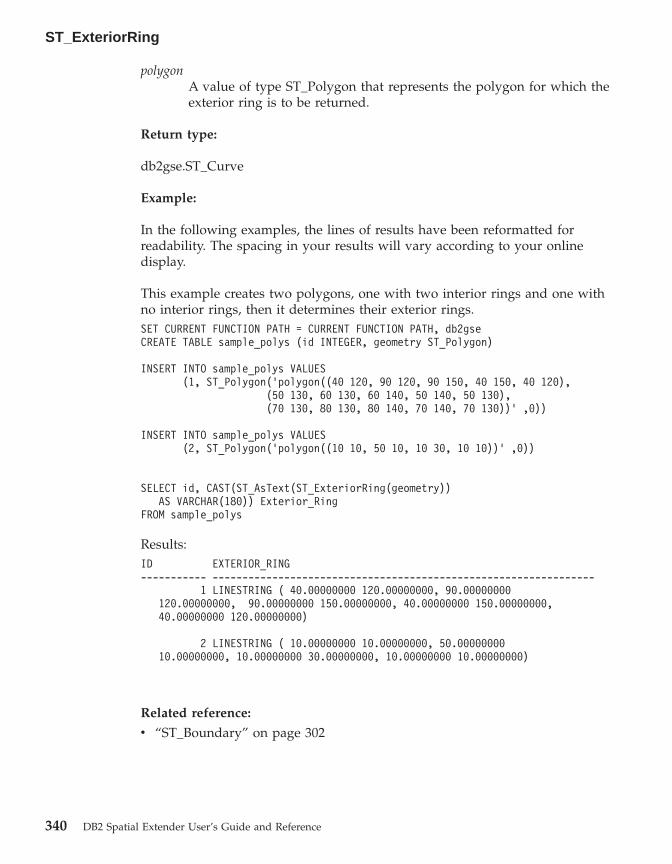
polygonA value of type ST_Polygon that represents the polygon for which theexterior ring is to be returned.
Return type:
db2gse.ST_Curve
Example:
In the following examples, the lines of results have been reformatted forreadability. The spacing in your results will vary according to your onlinedisplay.
This example creates two polygons, one with two interior rings and one withno interior rings, then it determines their exterior rings.SET CURRENT FUNCTION PATH = CURRENT FUNCTION PATH, db2gseCREATE TABLE sample_polys (id INTEGER, geometry ST_Polygon)
INSERT INTO sample_polys VALUES(1, ST_Polygon(’polygon((40 120, 90 120, 90 150, 40 150, 40 120),
(50 130, 60 130, 60 140, 50 140, 50 130),(70 130, 80 130, 80 140, 70 140, 70 130))’ ,0))
INSERT INTO sample_polys VALUES(2, ST_Polygon(’polygon((10 10, 50 10, 10 30, 10 10))’ ,0))
SELECT id, CAST(ST_AsText(ST_ExteriorRing(geometry))AS VARCHAR(180)) Exterior_Ring
FROM sample_polys
Results:ID EXTERIOR_RING----------- ----------------------------------------------------------------
1 LINESTRING ( 40.00000000 120.00000000, 90.00000000120.00000000, 90.00000000 150.00000000, 40.00000000 150.00000000,40.00000000 120.00000000)
2 LINESTRING ( 10.00000000 10.00000000, 50.0000000010.00000000, 10.00000000 30.00000000, 10.00000000 10.00000000)
Related reference:
v “ST_Boundary” on page 302
ST_ExteriorRing
340 DB2 Spatial Extender User’s Guide and Reference

ST_FindMeasure or ST_LocateAlong
ST_FindMeasure or ST_LocateAlong takes a geometry and a measure as inputparameters and returns a multipoint or multicurve of that part of the givengeometry that has exactly the specified measure of the given geometry thatcontains the specified measure. For points and multipoints, all the points withthe specified measure are returned. For curves, multicurves, surfaces, andmultisurfaces, interpolation is performed to compute the result. Thecomputation for surfaces and multisurfaces is performed on the boundary ofthe geometry.
For points and multipoints, if the given measure is not found, then an emptygeometry is returned. For all other geometries, if the given measure is lowerthan the lowest measure in the geometry or higher than the highest measurein the geometry, then an empty geometry is returned. If the given geometry isnull, then null is returned.
This function can also be called as a method.
Syntax:
�� db2gse.ST_FindMeasuredb2gse.ST_LocateAlong
( geometry , measure ) ��
Parameter:
geometryA value of type ST_Geometry or one of its subtypes that representsthe geometry in which to search for parts whose M coordinates(measures) contain measure.
measureA value of type DOUBLE that is the measure that the parts ofgeometry must be included in the result.
Return type:
db2gse.ST_Geometry
Examples:
The following CREATE TABLE statement creates the SAMPLE_GEOMETRIEStable. SAMPLE_GEOMETRIES has two columns: the ID column, whichuniquely identifies each row, and the GEOMETRY ST_Geometry column,which stores sample geometry.
ST_FindMeasure or ST_LocateAlong
Chapter 19. Spatial functions: syntax and parameters 341

SET CURRENT FUNCTION PATH = CURRENT FUNCTION PATH, db2gse
CREATE TABLE sample_geometries(id SMALLINT, geometry ST_GEOMETRY)
The following INSERT statements insert two rows. The first is a linestring; thesecond is a multipoint.INSERT INTO sample_geometries(id, geometry)VALUES
(1, ST_LineString(’linestring m (2 2 3, 3 5 3, 3 3 6, 4 4 8)’, 1)),(2, ST_MultiPoint(’multipoint m
(2 2 3, 3 5 3, 3 3 6, 4 4 6, 5 5 6, 6 6 8)’, 1))
Example 1:
In the following SELECT statement and the corresponding result set, theST_FindMeasure function is directed to find points whose measure is 7. Thefirst row returns a point. However, the second row returns an empty point.For linear features (geometry with a dimension greater than 0),ST_FindMeasure can interpolate the point; however, for multipoints, the targetmeasure must match exactly.SELECT id, cast(ST_AsText(ST_FindMeasure(geometry, 7))
AS varchar(45)) AS measure_7FROM sample_geometries
Results:ID MEASURE_7------ ---------------------------------------------
1 POINT M ( 3.50000000 3.50000000 7.00000000)2 POINT EMPTY
Example 2:
In the following SELECT statement and the corresponding result set, theST_FindMeasure function returns a point and a multipoint. The targetmeasure of 6 matches the measures in both the ST_FindMeasure andmultipoint source data.SELECT id, cast(ST_AsText(ST_FindMeasure(geometry, 6))
AS varchar(120)) AS measure_6FROM sample_geometries
Results:ID MEASURE_6------ --------------------------------------------------------------1 POINT M ( 3.00000000 3.00000000 6.00000000)
2 MULTIPOINT M ( 3.00000000 3.00000000 6.00000000, 4.000000004.00000000 6.00000000, 5.00000000 5.00000000 6.00000000)
Related reference:
ST_FindMeasure or ST_LocateAlong
342 DB2 Spatial Extender User’s Guide and Reference

v “ST_MeasureBetween, ST_LocateBetween” on page 397
ST_Generalize
ST_Generalize takes a geometry and a threshold as input parameters andrepresents the given geometry with a reduced number of points, whilepreserving the general characteristics of the geometry. The Douglas-Deckerline-simplification algorithm is used, by which the sequence of points thatdefine the geometry is recursively subdivided until a run of the points can bereplaced by a straight line segment. In this line segment, none of the definingpoints deviates from the straight line segment by more than the giventhreshold. Z and M coordinates are not considered for the simplification. Theresulting geometry is in the spatial reference system of the given geometry.
If the given geometry is empty, then an empty geometry of type ST_Point isreturned. If the given geometry or the threshold is null, then null is returned.
This function can also be called as a method.
Syntax:
�� db2gse.ST_Generalize ( geometry , threshold ) ��
Parameter:
geometryA value of type ST_Geometry or one of its subtypes that representsthe geometry for which the line-simplification is applied.
thresholdA value of type DOUBLE that identifies the threshold to be used forthe line-simplification algorithm. The threshold must be larger than orequal to 0 (zero). The larger the threshold, the smaller the number ofpoints that will be used to represent the generalized geometry.
Return type:
db2gse.ST_Geometry
Examples:
In the following examples, the lines of results have been reformatted forreadability. The spacing in your results will vary according to your onlinedisplay.
ST_FindMeasure or ST_LocateAlong
Chapter 19. Spatial functions: syntax and parameters 343

A linestring is created with eight points that go from (10, 10) to (80, 80). Thepath is almost a straight line, but some of the points are slightly off of theline. The ST_Generalize function can be used to reduce the number of pointsin the line.SET CURRENT FUNCTION PATH = CURRENT FUNCTION PATH, db2gseCREATE TABLE sample_lines (id INTEGER, geometry ST_LineString)
INSERT INTO sample_lines VALUES(1, ST_Linestring(’linestring(10 10, 21 20, 34 26, 40 40,
52 50, 59 63, 70 71, 80 80)’ ,0))
Example 1:
When a generalization factor of 3 is used, the linestring is reduced to fourcoordinates, and is still very close to the original representation of thelinestring.SELECT CAST(ST_AsText(ST_Generalize(geometry, 3)) as VARCHAR(115))
Generalize_3FROM sample_lines
Results:GENERALIZE 3----------------------------------------------------------------------LINESTRING ( 10.00000000 10.00000000, 34.00000000 26.00000000,
59.00000000 63.00000000, 80.00000000 80.00000000)
Example 2:
When a generalization factor of 6 is used, the linestring is reduced to only twocoordinates. This produces a simpler linestring than the previous example,however it deviates more from the original representation.SELECT CAST(ST_AsText(ST_Generalize(geometry, 6)) as VARCHAR(65))
Generalize_6FROM sample_lines
Results:GENERALIZE 6----------------------------------------------------------------LINESTRING ( 10.00000000 10.00000000, 80.00000000 80.00000000)
ST_Generalize
344 DB2 Spatial Extender User’s Guide and Reference

ST_GeomCollection
ST_GeomCollection constructs a geometry collection from one of the followinginputs:v A well-known text representationv A well-known binary representationv An ESRI shape representationv A representation in the geography markup language (GML)
An optional spatial reference system identifier can be specified to identify thespatial reference system that the resulting geometry collection is in.
If the well-known text representation, the well-known binary representation,the ESRI shape representation, or the GML representation is null, then null isreturned.
Syntax:
�� db2gse.ST_GeomCollection ( wktwkbshapegml
, srs_id) ��
Parameter:
wkt A value of type CLOB(2G) that contains the well-known textrepresentation of the resulting geometry collection.
wkb A value of type BLOB(2G) that contains the well-known binaryrepresentation of the resulting geometry collection.
shape A value of type BLOB(2G) that represents the ESRI shaperepresentation of the resulting geometry collection.
gml A value of type CLOB(2G) that represents the resulting geometrycollection using the geography markup language (GML).
srs_id A value of type INTEGER that identifies the spatial reference systemfor the resulting geometry collection.
If the srs_id parameter is omitted, the spatial reference system withthe numeric identifier 0 (zero) is used implicitly.
If srs_id does not identify a spatial reference system listed in thecatalog view DB2GSE.ST_SPATIAL_REFERENCE_SYSTEMS, then anerror is returned (SQLSTATE 38SU1).
Return type:
ST_GeomCollection
Chapter 19. Spatial functions: syntax and parameters 345

db2gse.ST_GeomCollection
Notes:
If the srs_id parameter is omitted, it might be necessary to cast wkt and gmlexplicitly to the CLOB data type. Otherwise, DB2 might resolve to thefunction used to cast values from the reference type REF(ST_GeomCollection)to the ST_GeomCollection type. The following example ensures that DB2resolves to the correct function:
Example:
In the following examples, the lines of results have been reformatted forreadability. The spacing in your results will vary according to your onlinedisplay.
The following code illustrates how the ST_GeomCollection function can beused to create and insert a multipoint, multiline, and multipolygon fromwell-known text (WKT) representation and a multipoint from geographicmarkup language (GML) into a GeomCollection column.SET CURRENT FUNCTION PATH = CURRENT FUNCTION PATH, db2gse
CREATE TABLE sample_geomcollections(id INTEGER,geometry ST_GEOMCOLLECTION)
INSERT INTO sample_geomcollections(id, geometry)VALUES
(4001, ST_GeomCollection(’multipoint(1 2, 4 3, 5 6)’, 1) ),(4002, ST_GeomCollection(’multilinestring(
(33 2, 34 3, 35 6),(28 4, 29 5, 31 8, 43 12),(39 3, 37 4, 36 7))’, 1) ),
(4003, ST_GeomCollection(’multipolygon(((3 3, 4 6, 5 3, 3 3),(8 24, 9 25, 1 28, 8 24),(13 33, 7 36, 1 40, 10 43, 13 33)))’, 1)),
(4004, ST_GeomCollection(’<gml:MultiPoint srsName="EPSG:4269"><gml:PointMember><gml:Point><gml:coord><gml:X>10</gml:X><gml:Y>20</gml:Y></gml: coord></gml:Point></gml:PointMember><gml:PointMember><gml:Point><gml:coord><gml:X>30</gml:X><gml:Y>40</gml:Y></gml:coord></gml:Point></gml:PointMember></gml:MultiPoint>’, 1))
SELECT id, cast(geometry..ST_AsText AS varchar(350)) AS geomcollectionFROM sample_geomcollections
Results:
ST_GeomCollection
346 DB2 Spatial Extender User’s Guide and Reference

ID GEOMCOLLECTION----------- -----------------------------------------------------------------4001 MULTIPOINT ( 1.00000000 2.00000000, 4.00000000 3.00000000,
5.00000000 6.00000000)
4002 MULTILINESTRING (( 33.00000000 2.00000000, 34.000000003.00000000, 35.00000000 6.00000000),( 28.00000000 4.00000000,29.00000000 5.00000000, 31.00000000 8.00000000, 43.0000000012.00000000),(39.00000000 3.00000000, 37.00000000 4.00000000,36.00000000 7.00000000))
4003 MULTIPOLYGON ((( 13.00000000 33.00000000, 10.0000000043.00000000, 1.00000000 40.00000000, 7.00000000 36.00000000,13.00000000 33.00000000)),(( 8.00000000 24.00000000, 9.0000000025.00000000, 1.00000000 28.00000000, 8.00000000 24.00000000)),(( 3.00000000 3.00000000,5.00000000 3.00000000, 4.000000006.00000000,3.00000000 3.00000000)))
4004 MULTIPOINT ( 10.00000000 20.00000000, 30.0000000040.00000000)
Related reference:
v “Well-known text (WKT) representation” on page 497v “Well-known binary (WKB) representation” on page 503v “Shape representation” on page 505v “Geography Markup Language (GML) representation” on page 505
ST_GeomCollFromTxt
ST_GeomCollFromTxt takes a well-known text representation of a geometrycollection and, optionally, a spatial reference system identifier as inputparameters and returns the corresponding geometry collection.
If the given well-known text representation is null, then null is returned.
The recommended function for achieving the same result isST_GeomCollection. It is recommended because of its flexibility:ST_GeomCollection takes additional forms of input as well as the well-knownbinary representation.
Syntax:
�� db2gse.ST_GeomCollFromTxt ( wkt, srs_id
) ��
Parameter:
wkt A value of type CLOB(2G) that contains the well-known textrepresentation of the resulting geometry collection.
ST_GeomCollection
Chapter 19. Spatial functions: syntax and parameters 347

srs_id A value of type INTEGER that identifies the spatial reference systemfor the resulting geometry collection.
If the srs_id parameter is omitted, the spatial reference system withthe numeric identifier 0 (zero) is used implicitly.
If srs_id does not identify a spatial reference system listed in thecatalog view DB2GSE.ST_SPATIAL_REFERENCE_SYSTEMS, then anerror is returned (SQLSTATE 38SU1).
Return type:
db2gse.ST_GeomCollection
Example:
In the following examples, the lines of results have been reformatted forreadability. The spacing in your results will vary according to your onlinedisplay.
The following code illustrates how the ST_GeomCollFromTxt function can beused to create and insert a multipoint, multiline, and multipolygon from awell-known text (WKT) representation into a GeomCollection column.SET CURRENT FUNCTION PATH = CURRENT FUNCTION PATH, db2gse
CREATE TABLE sample_geomcollections(id INTEGER, geometry ST_GEOMCOLLECTION)
INSERT INTO sample_geomcollections(id, geometry)VALUES
(4011, ST_GeomCollFromTxt(’multipoint(1 2, 4 3, 5 6)’, 1) ),(4012, ST_GeomCollFromTxt(’multilinestring(
(33 2, 34 3, 35 6),(28 4, 29 5, 31 8, 43 12),(39 3, 37 4, 36 7))’, 1) ),
(4013, ST_GeomCollFromTxt(’multipolygon(((3 3, 4 6, 5 3, 3 3),(8 24, 9 25, 1 28, 8 24),(13 33, 7 36, 1 40, 10 43, 13 33)))’, 1))
SELECT id, cast(geometry..ST_AsText AS varchar(340))AS geomcollection
FROM sample_geomcollections
Results:ID GEOMCOLLECTION----------- -----------------------------------------------------------------4011 MULTIPOINT ( 1.00000000 2.00000000, 4.00000000 3.00000000,
5.00000000 6.00000000)
4012 MULTILINESTRING (( 33.00000000 2.00000000, 34.000000003.00000000, 35.00000000 6.00000000),( 28.00000000 4.00000000, 29.000000005.00000000, 31.00000000 8.00000000, 43.00000000 12.00000000),( 39.00000000
ST_GeomCollFromTxt
348 DB2 Spatial Extender User’s Guide and Reference
3.00000000, 37.00000000 4.00000000, 36.00000000 7.00000000))
4013 MULTIPOLYGON ((( 13.00000000 33.00000000, 10.00000000 43.00000000,1.00000000 40.00000000, 7.00000000 36.00000000, 13.00000000 33.00000000)),(( 8.00000000 24.00000000, 9.00000000 25.00000000, 1.00000000 28.00000000,8.00000000 24.00000000)),(( 3.00000000 3.00000000, 5.00000000 3.00000000,4.00000000 6.00000000, 3.00000000 3.00000000)))
Related reference:
v “ST_GeomCollection” on page 345
ST_GeomCollFromWKB
ST_GeomCollFromWKB takes a well-known binary representation of ageometry collection and, optionally, a spatial reference system identifier asinput parameters and returns the corresponding geometry collection.
If the given well-known binary representation is null, then null is returned.
The preferred version for this functionality is ST_GeomCollection.
Syntax:
�� db2gse.ST_GeomCollFromTxt ( wkb, srs_id
) ��
Parameter:
wkb A value of type BLOB(2G) that contains the well-known binaryrepresentation of the resulting geometry collection.
srs_id A value of type INTEGER that identifies the spatial reference systemfor the resulting geometry collection.
If the srs_id parameter is omitted, the spatial reference system withthe numeric identifier 0 (zero) is used implicitly.
If srs_id does not identify a spatial reference system listed in thecatalog view DB2GSE.ST_SPATIAL_REFERENCE_SYSTEMS, then anerror is returned (SQLSTATE 38SU1).
Return type:
db2gse.ST_GeomCollection
Example:
ST_GeomCollFromTxt
Chapter 19. Spatial functions: syntax and parameters 349

In the following examples, the lines of results have been reformatted forreadability. The spacing in your results will vary according to your onlinedisplay.
The following code illustrates how the ST_GeomCollFromWKB function canbe used to create and query the coordinates of a geometry collection in awell-known binary representation. The rows are inserted into theSAMPLE_GEOMCOLLECTION table with IDs 4021 and 4022 and geometrycollections in spatial reference system 1.SET CURRENT FUNCTION PATH = CURRENT FUNCTION PATH, db2gse
CREATE TABLE sample_geomcollections(id INTEGER,geometry ST_GEOMCOLLECTION, wkb BLOB(32k))
INSERT INTO sample_geomcollections(id, geometry)VALUES
(4021, ST_GeomCollFromTxt(’multipoint(1 2, 4 3, 5 6)’, 1)),(4022, ST_GeomCollFromTxt(’multilinestring(
(33 2, 34 3, 35 6),(28 4, 29 5, 31 8, 43 12))’, 1))
UPDATE sample_geomcollections AS temp_correlatedSET wkb = geometry..ST_AsBinaryWHERE id = temp_correlated.id
SELECT id, cast(ST_GeomCollFromWKB(wkb)..ST_AsTextAS varchar(190)) AS GeomCollection
FROM sample_geomcollections
Results:ID GEOMCOLLECTION----------- -----------------------------------------------------
4021 MULTIPOINT ( 1.00000000 2.00000000, 4.000000003.00000000, 5.00000000 6.00000000)
4022 MULTILINESTRING (( 33.00000000 2.00000000,34.00000000 3.00000000, 35.00000000 6.00000000),( 28.000000004.00000000, 29.00000000 5.00000000, 31.00000000 8.00000000,43.00000000 12.00000000))
Related reference:
v “Well-known binary (WKB) representation” on page 503
ST_GeomCollFromWKB
350 DB2 Spatial Extender User’s Guide and Reference

ST_Geometry
ST_Geometry constructs a geometry from one of the following inputs:v A well-known text representationv A well-known binary representationv An ESRI shape representationv A representation in the geography markup language (GML)
An optional spatial reference system identifier can be specified to identify thespatial reference system that the resulting geometry is in.
The dynamic type of the resulting geometry is one of the instantiablesubtypes of ST_Geometry.
If the well-known text representation, the well-known binary representation,the ESRI shape representation, or the GML representation is null, then null isreturned.
Syntax:
�� db2gse.ST_Geometry ( wktwkbshapegml
, srs_id) ��
Parameter:
wkt A value of type CLOB(2G) that contains the well-known textrepresentation of the resulting geometry.
wkb A value of type BLOB(2G) that contains the well-known binaryrepresentation of the resulting geometry.
shape A value of type BLOB(2G) that represents the ESRI shaperepresentation of the resulting geometry.
gml A value of type CLOB(2G) that represents the resulting geometryusing the geography markup language (GML).
srs_id A value of type INTEGER that identifies the spatial reference systemfor the resulting geometry.
If the srs_id parameter is omitted, the spatial reference system withthe numeric identifier 0 (zero) is used implicitly.
If srs_id does not identify a spatial reference system listed in thecatalog view DB2GSE.ST_SPATIAL_REFERENCE_SYSTEMS, then anerror is returned (SQLSTATE 38SU1).
ST_Geometry
Chapter 19. Spatial functions: syntax and parameters 351

Return type:
db2gse.ST_Geometry
Example:
In the following examples, the lines of results have been reformatted forreadability. The spacing in your results will vary according to your onlinedisplay.
The following code illustrates how the ST_Geometry function can be used tocreate and insert a point from a well-known text (WKT) point representationor line from Geographic Markup Language (GML) line representation.
The ST_Geometry function is the most flexible of the spatial type constructorfunctions because it can create any spatial type from various geometryrepresentations. ST_LineFromText can create only a line from WKT linerepresentation. ST_WKTToSql can construct any type, but only from WKTrepresentation.SET CURRENT FUNCTION PATH = CURRENT FUNCTION PATH, db2gse
CREATE TABLE sample_geometries(id INTEGER, geometry ST_GEOMETRY)
INSERT INTO sample_geometries(id, geometry)VALUES
(7001, ST_Geometry(’point(1 2)’, 1) ),(7002, ST_Geometry(’linestring(33 2, 34 3, 35 6)’, 1) ),(7003, ST_Geometry(’polygon((3 3, 4 6, 5 3, 3 3))’, 1)),(7004, ST_Geometry(’<gml:Point srsName=";EPSG:4269";><gml:coord>
<gml:X>50</gml:X><gml:Y>60</gml:Y></gml:coord></gml:Point>’, 1))
SELECT id, cast(geometry..ST_AsText AS varchar(120)) AS geometryFROM sample_geometries
Results:ID GEOMETRY----------- ------------------------------------------------------------7001 POINT ( 1.00000000 2.00000000)
7002 LINESTRING ( 33.00000000 2.00000000, 34.00000000 3.00000000,35.00000000 6.00000000)
7003 POLYGON (( 3.00000000 3.00000000, 5.00000000 3.00000000,4.00000000 6.00000000, 3.00000000 3.00000000))
7004 POINT ( 50.00000000 60.00000000)
Related reference:
v “Well-known text (WKT) representation” on page 497
ST_Geometry
352 DB2 Spatial Extender User’s Guide and Reference
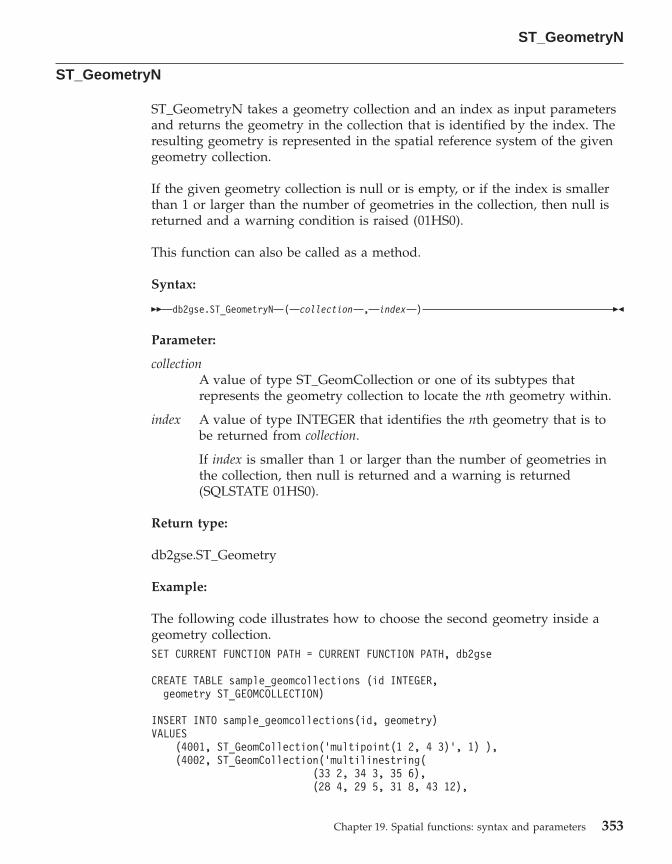
ST_GeometryN
ST_GeometryN takes a geometry collection and an index as input parametersand returns the geometry in the collection that is identified by the index. Theresulting geometry is represented in the spatial reference system of the givengeometry collection.
If the given geometry collection is null or is empty, or if the index is smallerthan 1 or larger than the number of geometries in the collection, then null isreturned and a warning condition is raised (01HS0).
This function can also be called as a method.
Syntax:
�� db2gse.ST_GeometryN ( collection , index ) ��
Parameter:
collectionA value of type ST_GeomCollection or one of its subtypes thatrepresents the geometry collection to locate the nth geometry within.
index A value of type INTEGER that identifies the nth geometry that is tobe returned from collection.
If index is smaller than 1 or larger than the number of geometries inthe collection, then null is returned and a warning is returned(SQLSTATE 01HS0).
Return type:
db2gse.ST_Geometry
Example:
The following code illustrates how to choose the second geometry inside ageometry collection.SET CURRENT FUNCTION PATH = CURRENT FUNCTION PATH, db2gse
CREATE TABLE sample_geomcollections (id INTEGER,geometry ST_GEOMCOLLECTION)
INSERT INTO sample_geomcollections(id, geometry)VALUES
(4001, ST_GeomCollection(’multipoint(1 2, 4 3)’, 1) ),(4002, ST_GeomCollection(’multilinestring(
(33 2, 34 3, 35 6),(28 4, 29 5, 31 8, 43 12),
ST_GeometryN
Chapter 19. Spatial functions: syntax and parameters 353

(39 3, 37 4, 36 7))’, 1) ),(4003, ST_GeomCollection(’multipolygon(((3 3, 4 6, 5 3, 3 3),
(8 24, 9 25, 1 28, 8 24),(13 33, 7 36, 1 40, 10 43, 13 33)))’, 1))
SELECT id, cast(ST_GeometryN(geometry, 2)..ST_AsText AS varchar(110))AS second_geometry
FROM sample_geomcollections
Results:ID SECOND_GEOMETRY----------- ----------------------------------------------------------
4001 POINT ( 4.00000000 3.00000000)
4002 LINESTRING ( 28.00000000 4.00000000, 29.00000000 5.00000000,31.00000000 8.00000000, 43.00000000 12.00000000)
4003 POLYGON (( 8.00000000 24.00000000, 9.00000000 25.00000000,1.00000000 28.00000000, 8.00000000 24.00000000))
Related reference:
v “ST_NumGeometries” on page 424
ST_GeometryType
ST_GeometryType takes a geometry as input parameter and returns the fullyqualified type name of the dynamic type of that geometry.
The DB2 functions TYPE_SCHEMA and TYPE_NAME have the same effect.
This function can also be called as a method.
Syntax:
�� db2gse.ST_GeometryType ( geometry ) ��
Parameter:
geometryA value of type ST_Geometry for which the geometry type is to bereturned.
Return type:
VARCHAR(128)
Examples:
ST_GeometryN
354 DB2 Spatial Extender User’s Guide and Reference
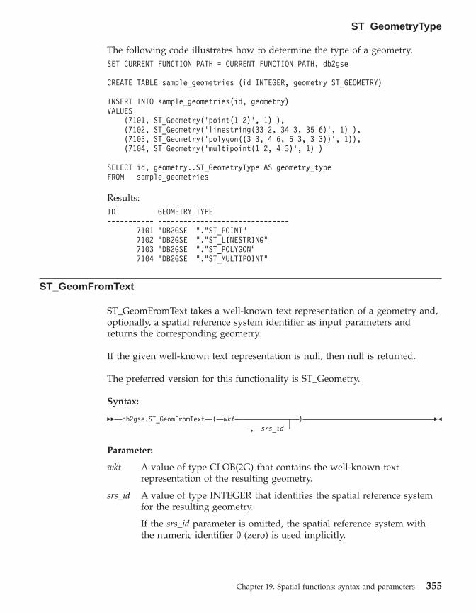
The following code illustrates how to determine the type of a geometry.SET CURRENT FUNCTION PATH = CURRENT FUNCTION PATH, db2gse
CREATE TABLE sample_geometries (id INTEGER, geometry ST_GEOMETRY)
INSERT INTO sample_geometries(id, geometry)VALUES
(7101, ST_Geometry(’point(1 2)’, 1) ),(7102, ST_Geometry(’linestring(33 2, 34 3, 35 6)’, 1) ),(7103, ST_Geometry(’polygon((3 3, 4 6, 5 3, 3 3))’, 1)),(7104, ST_Geometry(’multipoint(1 2, 4 3)’, 1) )
SELECT id, geometry..ST_GeometryType AS geometry_typeFROM sample_geometries
Results:ID GEOMETRY_TYPE----------- -------------------------------
7101 "DB2GSE "."ST_POINT"7102 "DB2GSE "."ST_LINESTRING"7103 "DB2GSE "."ST_POLYGON"7104 "DB2GSE "."ST_MULTIPOINT"
ST_GeomFromText
ST_GeomFromText takes a well-known text representation of a geometry and,optionally, a spatial reference system identifier as input parameters andreturns the corresponding geometry.
If the given well-known text representation is null, then null is returned.
The preferred version for this functionality is ST_Geometry.
Syntax:
�� db2gse.ST_GeomFromText ( wkt, srs_id
) ��
Parameter:
wkt A value of type CLOB(2G) that contains the well-known textrepresentation of the resulting geometry.
srs_id A value of type INTEGER that identifies the spatial reference systemfor the resulting geometry.
If the srs_id parameter is omitted, the spatial reference system withthe numeric identifier 0 (zero) is used implicitly.
ST_GeometryType
Chapter 19. Spatial functions: syntax and parameters 355

If srs_id does not identify a spatial reference system listed in thecatalog view DB2GSE.ST_SPATIAL_REFERENCE_SYSTEMS, then anerror is returned (SQLSTATE 38SU1).
Return type:
db2gse.ST_Geometry
Example:
In the following examples, the lines of results have been reformatted forreadability. The spacing in your results will vary according to your onlinedisplay.
In this example the ST_GeomFromText function is used to create and insert apoint from a well known text (WKT) point representation.
The following code inserts rows into the SAMPLE_POINTS table with IDs andgeometries in spatial reference system 1 using WKT representation.SET CURRENT FUNCTION PATH = CURRENT FUNCTION PATH, db2gse
CREATE TABLE sample_geometries(id INTEGER, geometry ST_GEOMETRY)
INSERT INTO sample_geometries(id, geometry)VALUES
(1251, ST_GeomFromText(’point(1 2)’, 1) ),(1252, ST_GeomFromText(’linestring(33 2, 34 3, 35 6)’, 1) ),(1253, ST_GeomFromText(’polygon((3 3, 4 6, 5 3, 3 3))’, 1))
The following SELECT statement will return the ID and GEOMETRIES fromthe SAMPLE_GEOMETRIES table.SELECT id, cast(geometry..ST_AsText AS varchar(105))
AS geometryFROM sample_geometries
Results:ID GEOMETRY----------- ---------------------------------------------------------------
1251 POINT ( 1.00000000 2.00000000)
1252 LINESTRING ( 33.00000000 2.00000000, 34.00000000 3.00000000,35.00000000 6.00000000)
1253 POLYGON (( 3.00000000 3.00000000, 5.00000000 3.00000000,4.00000000 6.00000000, 3.00000000 3.00000000))
Related reference:
v “Well-known text (WKT) representation” on page 497
ST_GeomFromText
356 DB2 Spatial Extender User’s Guide and Reference

ST_GeomFromWKB
ST_GeomFromWKB takes a well-known binary representation of a geometryand, optionally, a spatial reference system identifier as input parameters andreturns the corresponding geometry.
If the given well-known binary representation is null, then null is returned.
The preferred version for this functionality is ST_Geometry.
Syntax:
�� db2gse.ST_GeomFromWKB ( wkb ), srs_id
��
Parameter:
wkb A value of type BLOB(2G) that contains the well-known binaryrepresentation of the resulting geometry.
srs_id A value of type INTEGER that identifies the spatial reference systemfor the resulting geometry.
If the srs_id parameter is omitted, the spatial reference system with thenumeric identifier 0 (zero) is used implicitly.
If the specified srs_id parameter does not identify a spatial reference systemlisted in the catalog view DB2GSE.ST_SPATIAL_REFERENCE_SYSTEMS, thenan error is returned (SQLSTATE 38SU1).
Return type:
db2gse.ST_Geometry
Examples:
In the following examples, the lines of results have been reformatted forreadability. The spacing in your results will vary according to your onlinedisplay.
The following code illustrates how the ST_GeomFromWKB function can beused to create and insert a line from a well-known binary (WKB) linerepresentation.
The following example inserts a record into the SAMPLE_GEOMETRIES tablewith an ID and a geometry in spatial reference system 1 in a WKBrepresentation.
ST_GeomFromWKB
Chapter 19. Spatial functions: syntax and parameters 357

SET CURRENT FUNCTION PATH = CURRENT FUNCTION PATH, db2gse
CREATE TABLE sample_geometries (id INTEGER, geometry ST_GEOMETRY,wkb BLOB(32K))
INSERT INTO sample_geometries(id, geometry)VALUES
(1901, ST_GeomFromText(’point(1 2)’, 1) ),(1902, ST_GeomFromText(’linestring(33 2, 34 3, 35 6)’, 1) ),(1903, ST_GeomFromText(’polygon((3 3, 4 6, 5 3, 3 3))’, 1))
UPDATE sample_geometries AS temp_correlatedSET wkb = geometry..ST_AsBinaryWHERE id = temp_correlated.id
SELECT id, cast(ST_GeomFromWKB(wkb)..ST_AsText AS varchar(190))AS geometry
FROM sample_geometries
Results:ID GEOMETRY----------- ----------------------------------------------------------1901 POINT ( 1.00000000 2.00000000)
1902 LINESTRING ( 33.00000000 2.00000000, 34.000000003.00000000, 35.00000000 6.00000000)
1903 POLYGON (( 3.00000000 3.00000000, 5.00000000 3.00000000,4.00000000 6.00000000, 3.00000000 3.00000000))
Related reference:
v “Well-known binary (WKB) representation” on page 503
ST_GetIndexParms
ST_GetIndexParms takes either the identifier for a spatial index or for aspatial column as an input parameter and returns the parameters used todefine the index or the index on the spatial column. If an additionalparameter number is specified, only the grid size identified by the number isreturned.
Syntax:
�� db2gse.ST_GetIndexParms ( index_schema , index_nametable_schema , table_name , column_name
�
ST_GeomFromWKB
358 DB2 Spatial Extender User’s Guide and Reference

�, grid_size_number
) ��
Parameter:
index_schemaA value of type VARCHAR(128) that identifies the schema in whichthe spatial index with the unqualified name index_name is in. Theschema name is case-sensitive and must be listed in theSYSCAT.SCHEMATA catalog view.
If this parameter is null, then the value of the CURRENT SCHEMAspecial register is used as the schema name for the spatial index.
index_nameA value of type VARCHAR(128) that contains the unqualified name ofthe spatial index for which the index parameters are returned. Theindex name is case-sensitive and must be listed in theSYSCAT.INDEXES catalog view for the schema index_schema.
table_schemaA value of type VARCHAR(128) that identifies the schema in whichthe table with the unqualified name table_name is in. The schemaname is case-sensitive and must be listed in the SYSCAT.SCHEMATAcatalog view.
If this is parameter null, then the value of the CURRENT SCHEMAspecial register is used as the schema name for the spatial index.
table_nameA value of type VARCHAR(128) that contains the unqualified name ofthe table with the spatial column column_name. The table name iscase-sensitive and must be listed in the SYSCAT.TABLES catalog viewfor the schema table_schema.
column_nameA value of type VARCHAR(128) that identifies the column in the tabletable_schema.table_name for which the index parameters of the spatialindex on that column are returned. The column name is case-sensitiveand must be listed in the SYSCAT.COLUMNS catalog view for thetable table_schema.table_name.
If there is no spatial index defined in the column, then an error israised (SQLSTATE 38SQ0).
grid_size_numberA DOUBLE value that identifies the parameter whose value or valuesare to be returned.
If this value is smaller than 1 or larger than 3, then an error is raised(SQLSTATE 38SQ1).
ST_GetIndexParms
Chapter 19. Spatial functions: syntax and parameters 359

Return type:
DOUBLE (if grid_size_number is specified)
If grid_size_number is not specified, then a table with the two columnsORDINAL and VALUE is returned. The column ORDINAL is of typeINTEGER, and the column VALUE is of type DOUBLE.
If the parameters are returned for a grid index, the ORDINAL columncontains the values 1, 2, and 3 for the first, second, and third grid size,respectively. The column VALUE contains the grid sizes.
The VALUE column contains the respective values for each of the parameters.
Examples:
This code creates a table with a spatial column and a spatial index.SET CURRENT FUNCTION PATH = CURRENT FUNCTION PATH, db2gse
CREATE TABLE sch.offices (name VARCHAR(30), location ST_Point )
CREATE INDEX sch.idx ON sch.offices(location)EXTEND USING db2gse.spatial_index(1e0, 10e0, 1000e0)
The ST_GetIndexParms function can be used to retrieve the values for theparameters that were used when the spatial index was created.
Example 1:
This example shows how to retrieve the three grid sizes for a spatial gridindex separately by explicitly specifying which parameter, identified by itsnumber, is to be returned.VALUES ST_GetIndexParms(’SCH’, ’OFFICES’, ’LOCATION’, 1)
Results:1------------------------
+1.00000000000000E+000
VALUES ST_GetIndexParms(’SCH’, ’OFFICES’, ’LOCATION’, 2)
Results:1------------------------
+1.00000000000000E+001
VALUES ST_GetIndexParms(’SCH’, ’IDX’, 3)
ST_GetIndexParms
360 DB2 Spatial Extender User’s Guide and Reference

Results:1------------------------
+1.00000000000000E+003
Example 2:
This example shows how to retrieve all the parameters of a spatial grid index.The ST_GetIndexParms function returns a table that indicates the parameternumber and the corresponding grid size.SELECT * FROM TABLE ( ST_GetIndexParms(’SCH’, ’OFFICES’, ’LOCATION’) ) AS t
Results:ORDINAL VALUE----------- ------------------------
1 +1.00000000000000E+0002 +1.00000000000000E+0013 +1.00000000000000E+003
SELECT * FROM TABLE ( ST_GetIndexParms(’SCH’, ’IDX’) ) AS t
Results:ORDINAL VALUE----------- ------------------------
1 +1.00000000000000E+0002 +1.00000000000000E+0013 +1.00000000000000E+003
Related concepts:
v “Spatial indexes” on page 105
ST_InteriorRingN
ST_InteriorRingN takes a polygon and an index as input parameters andreturns the interior ring identified by the given index as a linestring. Theinterior rings are organized according to the rules defined by the internalgeometry verification routines and not by any geometric orientation.
If the given polygon is null or is empty, or if it does not have any interiorrings, then null is returned. If the index is smaller than 1 or larger than thenumber of interior rings in the polygon, then null is returned and a warningcondition is raised (1HS1).
This function can also be called as a method.
Syntax:
ST_GetIndexParms
Chapter 19. Spatial functions: syntax and parameters 361

�� db2gse.ST_InteriorRingN ( polygon , index ) ��
Parameter:
polygonA value of type ST_Polygon that represents the geometry from whichthe interior ring identified by index is returned.
index A value of type INTEGER that identifies the nthe interior ring that isreturned. If there is no interior ring identified by index, then awarning condition is raised (01HS1).
Return type:
db2gse.ST_Curve
Example:
In this example, a polygon is created with two interior rings. TheST_InteriorRingN call is then used to retrieve the second interior ring.SET CURRENT FUNCTION PATH = CURRENT FUNCTION PATH, db2gseCREATE TABLE sample_polys (id INTEGER, geometry ST_Polygon)
INSERT INTO sample_polys VALUES(1, ST_Polygon(’polygon((40 120, 90 120, 90 150, 40 150, 40 120),
(50 130, 60 130, 60 140, 50 140, 50 130),(70 130, 80 130, 80 140, 70 140, 70 130))’ ,0))
SELECT id, CAST(ST_AsText(ST_InteriorRingN(geometry, 2)) as VARCHAR(180))Interior_Ring
FROM sample_polys
Results:ID INTERIOR_RING----------- ------------------------------------------------------------------
1 LINESTRING ( 70.00000000 130.00000000, 70.00000000 140.00000000,80.00000000 140.00000000, 80.00000000 130.00000000, 70.00000000 130.00000000)
Related reference:
v “ST_ExteriorRing” on page 339v “ST_NumInteriorRing” on page 425
ST_InteriorRingN
362 DB2 Spatial Extender User’s Guide and Reference

ST_Intersection
ST_Intersection takes two geometries as input parameters and returns thegeometry that is the intersection of the two given geometries. The intersectionis the part of the first geometry that is also part of the second geometry. Theresulting geometry is represented in the spatial reference system of the firstgeometry.
If the second geometry is not represented in the same spatial reference systemas the first geometry, it will be converted to the other spatial reference system.
If possible, the specific type of the returned geometry will be ST_Point,ST_LineString, or ST_Polygon. For example, the boundary of a polygon withno holes is a single linestring, represented as ST_LineString. The boundary ofa polygon with one or more holes consists of multiple linestrings, representedas ST_MultiLineString.
If any of the two given geometries is null, then null is returned.
This function can also be called as a method.
Syntax:
�� db2gse.ST_Intersection ( geometry1 , geometry2 ) ��
Parameter:
geometry1A value of type ST_Geometry or one of its subtypes that representsthe first geometry to compute the intersection with geometry2.
geometry2A value of type ST_Geometry or one of its subtypes that representsthe second geometry to compute the intersection with geometry1.
Return type:
db2gse.ST_Geometry
Example:
In the following examples, the lines of results have been reformatted forreadability. The spacing in your results will vary according to your onlinedisplay.
This example creates several different geometries and then determines theintersection (if any) with the first one.
ST_Intersection
Chapter 19. Spatial functions: syntax and parameters 363

SET CURRENT FUNCTION PATH = CURRENT FUNCTION PATH, db2gseCREATE TABLE sample_geoms (id INTEGER, geometry ST_Geometry)
INSERT INTO sample_geoms VALUES(1, ST_Geometry(’polygon((30 30, 30 50, 50 50, 50 30, 30 30))’ ,0))
INSERT INTO sample_geoms VALUES(2, ST_Geometry(’polygon((20 30, 30 30, 30 40, 20 40, 20 30))’ ,0))
INSERT INTO sample_geoms VALUES(3, ST_Geometry(’polygon((40 40, 40 60, 60 60, 60 40, 40 40))’ ,0))
INSERT INTO sample_geoms VALUES(4, ST_Geometry(’linestring(60 60, 70 70)’ ,0))
INSERT INTO sample_geoms VALUES(5, ST_Geometry(’linestring(30 30, 60 60)’ ,0))
SELECT a.id, b.id, CAST(ST_AsText(ST_Intersection(a.geometry, b.geometry))as VARCHAR(150)) Intersection
FROM sample_geoms a, sample_geoms bWHERE a.id = 1
Results:ID ID INTERSECTION----------- ----------- ------------------------------------------------
1 1 POLYGON (( 30.00000000 30.00000000, 50.0000000030.00000000, 50.00000000 50.00000000, 30.00000000 50.00000000, 30.0000000030.00000000))
1 2 LINESTRING ( 30.00000000 40.00000000, 30.0000000030.00000000)
1 3 POLYGON (( 40.00000000 40.00000000, 50.0000000040.00000000, 50.00000000 50.00000000, 40.00000000 50.00000000, 40.0000000040.00000000))
1 4 POINT EMPTY
1 5 LINESTRING ( 30.00000000 30.00000000, 50.0000000050.00000000)
5 record(s) selected.
ST_Intersects
ST_Intersects takes two geometries as input parameters and returns 1 if thegiven geometries intersect. If the geometries do not intersect, then 0 (zero) isreturned.
If the second geometry is not represented in the same spatial reference systemas the first geometry, it will be converted to the other spatial reference system.
ST_Intersection
364 DB2 Spatial Extender User’s Guide and Reference
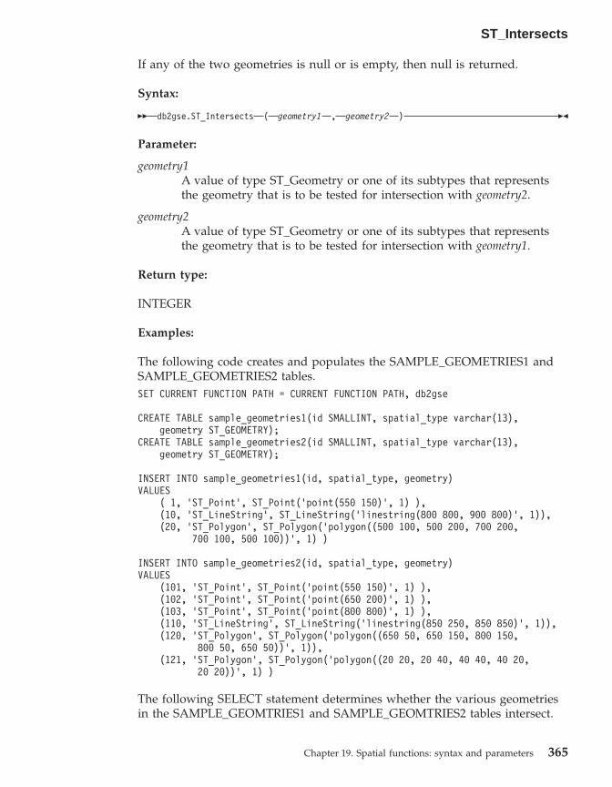
If any of the two geometries is null or is empty, then null is returned.
Syntax:
�� db2gse.ST_Intersects ( geometry1 , geometry2 ) ��
Parameter:
geometry1A value of type ST_Geometry or one of its subtypes that representsthe geometry that is to be tested for intersection with geometry2.
geometry2A value of type ST_Geometry or one of its subtypes that representsthe geometry that is to be tested for intersection with geometry1.
Return type:
INTEGER
Examples:
The following code creates and populates the SAMPLE_GEOMETRIES1 andSAMPLE_GEOMETRIES2 tables.SET CURRENT FUNCTION PATH = CURRENT FUNCTION PATH, db2gse
CREATE TABLE sample_geometries1(id SMALLINT, spatial_type varchar(13),geometry ST_GEOMETRY);
CREATE TABLE sample_geometries2(id SMALLINT, spatial_type varchar(13),geometry ST_GEOMETRY);
INSERT INTO sample_geometries1(id, spatial_type, geometry)VALUES
( 1, ’ST_Point’, ST_Point(’point(550 150)’, 1) ),(10, ’ST_LineString’, ST_LineString(’linestring(800 800, 900 800)’, 1)),(20, ’ST_Polygon’, ST_Polygon(’polygon((500 100, 500 200, 700 200,
700 100, 500 100))’, 1) )
INSERT INTO sample_geometries2(id, spatial_type, geometry)VALUES
(101, ’ST_Point’, ST_Point(’point(550 150)’, 1) ),(102, ’ST_Point’, ST_Point(’point(650 200)’, 1) ),(103, ’ST_Point’, ST_Point(’point(800 800)’, 1) ),(110, ’ST_LineString’, ST_LineString(’linestring(850 250, 850 850)’, 1)),(120, ’ST_Polygon’, ST_Polygon(’polygon((650 50, 650 150, 800 150,
800 50, 650 50))’, 1)),(121, ’ST_Polygon’, ST_Polygon(’polygon((20 20, 20 40, 40 40, 40 20,
20 20))’, 1) )
The following SELECT statement determines whether the various geometriesin the SAMPLE_GEOMTRIES1 and SAMPLE_GEOMTRIES2 tables intersect.
ST_Intersects
Chapter 19. Spatial functions: syntax and parameters 365
SELECT sg1.id AS sg1_id, sg1.spatial_type AS sg1_type,sg2.id AS sg2_id, sg2.spatial_type AS sg2_type,CASE ST_Intersects(sg1.geometry, sg2.geometry)
WHEN 0 THEN ’Geometries do not intersect’WHEN 1 THEN ’Geometries intersect’
END AS intersectsFROM sample_geometries1 sg1, sample_geometries2 sg2ORDER BY sg1.id
Results:SG1_ID SG1_TYPE SG2_ID SG2_TYPE INTERSECTS------ ------------- ------ ------------- ---------------------------
1 ST_Point 101 ST_Point Geometries intersect1 ST_Point 102 ST_Point Geometries do not intersect1 ST_Point 103 ST_Point Geometries do not intersect1 ST_Point 110 ST_LineString Geometries do not intersect1 ST_Point 120 ST_Polygon Geometries do not intersect1 ST_Point 121 ST_Polygon Geometries do not intersect10 ST_LineString 101 ST_Point Geometries do not intersect10 ST_LineString 102 ST_Point Geometries do not intersect10 ST_LineString 103 ST_Point Geometries intersect10 ST_LineString 110 ST_LineString Geometries intersect10 ST_LineString 120 ST_Polygon Geometries do not intersect10 ST_LineString 121 ST_Polygon Geometries do not intersect20 ST_Polygon 101 ST_Point Geometries intersect20 ST_Polygon 102 ST_Point Geometries intersect20 ST_Polygon 103 ST_Point Geometries do not intersect20 ST_Polygon 110 ST_LineString Geometries do not intersect20 ST_Polygon 120 ST_Polygon Geometries intersect20 ST_Polygon 121 ST_Polygon Geometries do not intersect
Related reference:
v “Functions that make comparisons” on page 252
ST_Is3d
ST_Is3d takes a geometry as an input parameter and returns 1 if the givengeometry has Z coordinates. Otherwise, 0 (zero) is returned.
If the given geometry is null or is empty, then null is returned.
This function can also be called as a method.
Syntax:
�� db2gse.ST_Is3D ( geometry ) ��
Parameter:
ST_Intersects
366 DB2 Spatial Extender User’s Guide and Reference

geometryA value of type ST_Geometry or one of its subtypes that representsthe geometry that is to be tested for the existence of Z coordinates.
Return type:
INTEGER
Example:
In this example, several geometries are created with and without Zcoordinates and M coordinates (measures). ST_Is3d is then used to determinewhich of them contain Z coordinates.SET CURRENT FUNCTION PATH = CURRENT FUNCTION PATH, db2gseCREATE TABLE sample_geoms (id INTEGER, geometry ST_Geometry)
INSERT INTO sample_geoms VALUES(1, ST_Geometry(’point EMPTY’,0))
INSERT INTO sample_geoms VALUES(2, ST_Geometry(’polygon((40 120, 90 120, 90 150, 40 150, 40 120))’ ,0))
INSERT INTO sample_geoms VALUES(3, ST_Geometry(’multipoint m (10 10 5, 50 10 6, 10 30 8)’ ,0))
INSERT INTO sample_geoms VALUES(4, ST_Geometry(’linestring z (10 10 166, 20 10 168)’,0))
INSERT INTO sample_geoms VALUES(5, ST_Geometry(’point zm (10 10 16 30)’ ,0))
SELECT id, ST_Is3d(geometry) Is_3DFROM sample_geoms
Results:ID IS_3D----------- -----------
1 02 03 04 15 1
ST_Is3d
Chapter 19. Spatial functions: syntax and parameters 367
ST_IsClosed
ST_IsClosed takes a curve or multicurve as an input parameter and returns 1if the given curve or multicurve is closed. Otherwise, 0 (zero) is returned.
A curve is closed if the start point and end point are equal. If the curve has Zcoordinates, the Z coordinates of the start and end point must be equal.Otherwise, the points are not considered equal, and the curve is not closed. Amulticurve is closed if each of its curves are closed.
If the given curve or multicurve is empty, then 0 (zero) is returned. If it isnull, then null is returned.
This function can also be called as a method.
Syntax:
�� db2gse.ST_IsClosed ( curve ) ��
Parameter:
curve A value of type ST_Curve or ST_MultiCurve or one of their subtypesthat represent the curve or multicurve that is to be tested.
Return type:
INTEGER
Examples:
Example 1:
This example creates several linestrings. The last two linestrings have thesame X and Y coordinates, but one linestring contains varying Z coordinatesthat cause the linestring to not be closed, and the other linestring containsvarying M coordinates (measures) that do not affect whether the linestring isclosed.SET CURRENT FUNCTION PATH = CURRENT FUNCTION PATH, db2gseCREATE TABLE sample_lines (id INTEGER, geometry ST_Linestring)
INSERT INTO sample_lines VALUES(1, ST_Linestring(’linestring EMPTY’,0))
INSERT INTO sample_lines VALUES(2, ST_Linestring(’linestring(10 10, 20 10, 20 20)’ ,0))
INSERT INTO sample_lines VALUES(3, ST_Linestring(’linestring(10 10, 20 10, 20 20, 10 10)’ ,0))
ST_IsClosed
368 DB2 Spatial Extender User’s Guide and Reference

INSERT INTO sample_lines VALUES(4, ST_Linestring(’linestring m(10 10 1, 20 10 2, 20 20 3,10 10 4)’ ,0))
INSERT INTO sample_lines VALUES(5, ST_Linestring(’linestring z(10 10 5, 20 10 6, 20 20 7,10 10 8)’ ,0))
SELECT id, ST_IsClosed(geometry) Is_ClosedFROM sample_lines
Results:ID IS_CLOSED----------- -----------
1 02 03 14 15 0
Example 2:
In this example, two multilinestrings are created. ST_IsClosed is used todetermine if the multilinestrings are closed. The first one is not closed, eventhough all of the curves together form a complete closed loop. This is becauseeach curve itself is not closed.
The second multilinestring is closed because each curve itself is closed.SET CURRENT FUNCTION PATH = CURRENT FUNCTION PATH, db2gseCREATE TABLE sample_mlines (id INTEGER, geometry ST_MultiLinestring)INSERT INTO sample_mlines VALUES
(6, ST_MultiLinestring(’multilinestring((10 10, 20 10, 20 20),(20 20, 30 20, 30 30),(30 30, 10 30, 10 10))’,0))
INSERT INTO sample_mlines VALUES(7, ST_MultiLinestring(’multilinestring((10 10, 20 10, 20 20, 10 10 ),
(30 30, 50 30, 50 50,30 30 ))’,0))
SELECT id, ST_IsClosed(geometry) Is_ClosedFROM sample_mlines
Results:
ST_IsClosed
Chapter 19. Spatial functions: syntax and parameters 369

ID IS_CLOSED----------- -----------
6 07 1
ST_IsEmpty
ST_IsEmpty takes a geometry as an input parameter and returns 1 if the givengeometry is empty. Otherwise 0 (zero) is returned. A geometry is empty if itdoes not have any points that define it.
If the given geometry is null, then null is returned.
This function can also be called as a method.
Syntax:
�� db2gse.ST_IsEmpty ( geometry ) ��
Parameter:
geometryA value of type ST_Geometry or one of its subtypes that representsthe geometry that is to be tested.
Return type:
INTEGER
Example:
The following code creates three geometries and then determines if they areempty.SET CURRENT FUNCTION PATH = CURRENT FUNCTION PATH, db2gseCREATE TABLE sample_geoms (id INTEGER, geometry ST_Geometry)
INSERT INTO sample_geoms VALUES(1, ST_Geometry(’point EMPTY’,0))
INSERT INTO sample_geoms VALUES(2, ST_Geometry(’polygon((40 120, 90 120, 90 150, 40 150, 40 120))’ ,0))
INSERT INTO sample_geoms VALUES(3, ST_Geometry(’multipoint m (10 10 5, 50 10 6, 10 30 8)’ ,0))
INSERT INTO sample_geoms VALUES(4, ST_Geometry(’linestring z (10 10 166, 20 10 168)’,0))
ST_IsClosed
370 DB2 Spatial Extender User’s Guide and Reference

INSERT INTO sample_geoms VALUES(5, ST_Geometry(’point zm (10 10 16 30)’ ,0))
SELECT id, ST_IsMeasured(geometry) Is_MeasuredFROM sample_geoms
Results:ID IS_MEASURED----------- -----------
1 02 03 14 05 1
ST_IsMeasured
ST_IsMeasured takes a geometry as an input parameter and returns 1 if thegiven geometry has M coordinates (measures). Otherwise 0 (zero) is returned.
If the given geometry is null or is empty, then null is returned.
This function can also be called as a method.
Syntax:
�� db2gse.ST_IsMeasured ( geometry ) ��
Parameter:
geometryA value of type ST_Geometry or one of its subtypes that representsthe geometry to be tested for the existence of M coordinates(measures).
Return type:
INTEGER
Example:
In this example, several geometries are created with and without Zcoordinates and M coordinates (measures). ST_IsMeasured is then used todetermine which of them contained measures.
ST_IsEmpty
Chapter 19. Spatial functions: syntax and parameters 371
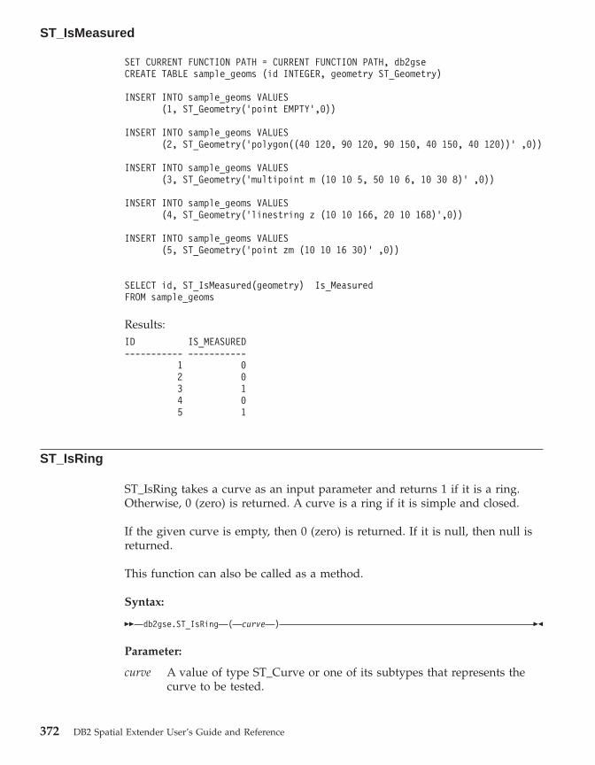
SET CURRENT FUNCTION PATH = CURRENT FUNCTION PATH, db2gseCREATE TABLE sample_geoms (id INTEGER, geometry ST_Geometry)
INSERT INTO sample_geoms VALUES(1, ST_Geometry(’point EMPTY’,0))
INSERT INTO sample_geoms VALUES(2, ST_Geometry(’polygon((40 120, 90 120, 90 150, 40 150, 40 120))’ ,0))
INSERT INTO sample_geoms VALUES(3, ST_Geometry(’multipoint m (10 10 5, 50 10 6, 10 30 8)’ ,0))
INSERT INTO sample_geoms VALUES(4, ST_Geometry(’linestring z (10 10 166, 20 10 168)’,0))
INSERT INTO sample_geoms VALUES(5, ST_Geometry(’point zm (10 10 16 30)’ ,0))
SELECT id, ST_IsMeasured(geometry) Is_MeasuredFROM sample_geoms
Results:ID IS_MEASURED----------- -----------
1 02 03 14 05 1
ST_IsRing
ST_IsRing takes a curve as an input parameter and returns 1 if it is a ring.Otherwise, 0 (zero) is returned. A curve is a ring if it is simple and closed.
If the given curve is empty, then 0 (zero) is returned. If it is null, then null isreturned.
This function can also be called as a method.
Syntax:
�� db2gse.ST_IsRing ( curve ) ��
Parameter:
curve A value of type ST_Curve or one of its subtypes that represents thecurve to be tested.
ST_IsMeasured
372 DB2 Spatial Extender User’s Guide and Reference

Return type:
INTEGER
Examples:
In this example, four linestrings are created. ST_IsRing is used to check if theyare rings. The last one is not considered a ring even though it is closedbecause the path crosses over itself.SET CURRENT FUNCTION PATH = CURRENT FUNCTION PATH, db2gseCREATE TABLE sample_lines (id INTEGER, geometry ST_Linestring)
INSERT INTO sample_lines VALUES(1, ST_Linestring(’linestring EMPTY’,0))
INSERT INTO sample_lines VALUES(2, ST_Linestring(’linestring(10 10, 20 10, 20 20)’ ,0))
INSERT INTO sample_lines VALUES(3, ST_Linestring(’linestring(10 10, 20 10, 20 20, 10 10)’ ,0))
INSERT INTO sample_lines VALUES(4, ST_Linestring(’linestring(10 10, 20 10, 10 20, 20 20, 10 10)’ ,0))
SELECT id, ST_IsClosed(geometry) Is_Closed, ST_IsRing(geometry) Is_RingFROM sample_lines
Results:ID IS_CLOSED IS_RING----------- ----------- -----------
1 1 02 0 03 1 14 1 0
Related reference:
v “ST_IsClosed” on page 368v “ST_IsSimple” on page 373
ST_IsSimple
ST_IsSimple takes a geometry as an input parameter and returns 1 if thegiven geometry is simple. Otherwise, 0 (zero) is returned.
ST_IsRing
Chapter 19. Spatial functions: syntax and parameters 373

Points, surfaces, and multisurfaces are always simple. A curve is simple if itdoes not pass through the same point twice; a multipoint is simple if it doesnot contain two equal points; and a multicurve is simple if all of its curves aresimple and the only intersections occur at points that are on the boundary ofthe curves in the multicurve.
If the given geometry is empty, then 1 is returned. If it is null, null isreturned.
This function can also be called as a method.
Syntax:
�� db2gse.ST_IsSimple ( geometry ) ��
Parameter:
geometryA value of type ST_Geometry or one of its subtypes that representsthe geometry to be tested.
Return type:
INTEGER
Examples:
In this example, several geometries are created and checked if they are simple.The geometry with an ID of 4 is not considered simple because it containsmore than one point that is the same. The geometry with an ID of 6 is notconsidered simple because the linestring crosses over itself.SET CURRENT FUNCTION PATH = CURRENT FUNCTION PATH, db2gseCREATE TABLE sample_geoms (id INTEGER, geometry ST_Geometry)
INSERT INTO sample_geoms VALUES(1, ST_Geometry(’point EMPTY’ ,0))
INSERT INTO sample_geoms VALUES(2, ST_Geometry(’point (21 33)’ ,0))
INSERT INTO sample_geoms VALUES(3, ST_Geometry(’multipoint(10 10, 20 20, 30 30)’ ,0))
INSERT INTO sample_geoms VALUES(4, ST_Geometry(’multipoint(10 10, 20 20, 30 30, 20 20)’ ,0))
INSERT INTO sample_geoms VALUES(5, ST_Geometry(’linestring(60 60, 70 60, 70 70)’ ,0))
INSERT INTO sample_geoms VALUES
ST_IsSimple
374 DB2 Spatial Extender User’s Guide and Reference

(6, ST_Geometry(’linestring(20 20, 30 30, 30 20, 20 30 )’ ,0))
INSERT INTO sample_geoms VALUES(7, ST_Geometry(’polygon((40 40, 50 40, 50 50, 40 40 ))’ ,0))
SELECT id, ST_IsSimple(geometry) Is_SimpleFROM sample_geoms
Results:ID IS_SIMPLE----------- -----------
1 12 13 14 05 16 07 1
ST_IsValid
ST_IsValid takes a geometry as an input parameter and returns 1 if it is valid.Otherwise 0 (zero) is returned. A geometry is valid only if all of the attributesin the structured type are consistent with the internal representation ofgeometry data, and if the internal representation is not corrupted.
If the given geometry is null, then null is returned.
This function can also be called as a method.
Syntax:
�� db2gse.ST_IsValid ( geometry ) ��
Parameter:
geometryA value of type ST_Geometry or one of its subtypes.
Return type:
INTEGER
Example:
ST_IsSimple
Chapter 19. Spatial functions: syntax and parameters 375

This example creates several geometries and uses ST_IsValid to check if theyare valid. All of the geometries are valid because the constructor routines,such as ST_Geometry, do not allow invalid geometries to be constructed.SET CURRENT FUNCTION PATH = CURRENT FUNCTION PATH, db2gseCREATE TABLE sample_geoms (id INTEGER, geometry ST_Geometry)
INSERT INTO sample_geoms VALUES(1, ST_Geometry(’point EMPTY’,0))
INSERT INTO sample_geoms VALUES(2, ST_Geometry(’polygon((40 120, 90 120, 90 150, 40 150, 40 120))’ ,0))
INSERT INTO sample_geoms VALUES(3, ST_Geometry(’multipoint m (10 10 5, 50 10 6, 10 30 8)’ ,0))
INSERT INTO sample_geoms VALUES(4, ST_Geometry(’linestring z (10 10 166, 20 10 168)’,0))
INSERT INTO sample_geoms VALUES(5, ST_Geometry(’point zm (10 10 16 30)’ ,0))
SELECT id, ST_IsValid(geometry) Is_ValidFROM sample_geoms
Results:ID IS_VALID----------- -----------
1 12 13 14 15 1
ST_Length
ST_Length takes a curve or multicurve and, optionally, a unit as inputparameters and returns the length of the given curve or multicurve in thegiven unit of measure.
If the given curve or multicurve is null or is empty, then null is returned.
This function can also be called as a method.
Syntax:
ST_IsValid
376 DB2 Spatial Extender User’s Guide and Reference

�� db2gse.ST_Length ( curve, unit
) ��
Parameter:
curve A value of type ST_Curve or ST_MultiCurve that represents thecurves for which the length is returned.
unit A VARCHAR(128) value that identifies the units in which the lengthof the curve is measured. The supported units of measure are listed inthe DB2GSE.ST_UNITS_OF_MEASURE catalog view.
If the unit parameter is omitted, the following rules are used todetermine the unit in which the length is measured:v If curve is in a projected or geocentric coordinate system, the linear
unit associated with this coordinate system is used.v If curve is in a geographic coordinate system, the angular unit
associated with this coordinate system is used.
If curve is in an unspecified coordinate system and unit is given, or ifthe geometry is in a geographic coordinate system and a linear unit isspecified, then an error is returned (SQLSTATE 38SU4).
Return type:
DOUBLE
Examples:
The following code creates a table SAMPLE_GEOMETRIES and inserts a lineand a multiline into the table.SET CURRENT FUNCTION PATH = CURRENT FUNCTION PATH, db2gse
CREATE TABLE sample_geometries(id SMALLINT, spatial_type varchar(20),geometry ST_GEOMETRY)
INSERT INTO sample_geometries(id, spatial_type, geometry)VALUES
(1110, ’ST_LineString’, ST_LineString(’linestring(50 10, 50 20)’, 1)),(1111, ’ST_MultiLineString’, ST_MultiLineString(’multilinestring
((33 2, 34 3, 35 6),(28 4, 29 5, 31 8, 43 12),(39 3, 37 4, 36 7))’, 1))
Example 1:
The following SELECT statement calculates the length of the line in theSAMPLE_GEOMTRIES table.
ST_Length
Chapter 19. Spatial functions: syntax and parameters 377
SELECT id, spatial_type, cast(ST_Length(geometry..ST_ToLineString)AS DECIMAL(7, 2)) AS "Line Length"
FROM sample_geometriesWHERE id = 1110
Results:ID SPATIAL_TYPE Line Length------ -------------------- -----------
1110 ST_LineString 10.00
Example 2:
The following SELECT statement calculates the length of the multiline in theSAMPLE_GEOMTRIES table.SELECT id, spatial_type, ST_Length(ST_ToMultiLine(geometry))
AS multiline_lengthFROM sample_geometriesWHERE id = 1111
Results:ID SPATIAL_TYPE MULTILINE_LENGTH------ -------------------- ------------------------
1111 ST_MultiLineString +2.76437123387202E+001
ST_LineFromText
ST_LineFromText takes a well-known text representation of a linestring and,optionally, a spatial reference system identifier as input parameters andreturns the corresponding linestring.
If the given well-known text representation is null, then null is returned.
The preferred version for this functionality is ST_LineString.
Syntax:
�� db2gse.ST_LineFromText ( wkt, srs_id
) ��
Parameter:
wkt A value of type CLOB(2G) that contains the well-known textrepresentation of the resulting linestring.
srs_id A value of type INTEGER that identifies the spatial reference systemfor the resulting linestring.
If the srs_id parameter is omitted, the spatial reference system withthe numeric identifier 0 (zero) is used.
ST_Length
378 DB2 Spatial Extender User’s Guide and Reference

If srs_id does not identify a spatial reference system listed in thecatalog view DB2GSE.ST_SPATIAL_REFERENCE_SYSTEMS, then anerror is returned (SQLSTATE 38SU1).
Return type:
db2gse.ST_LineString
Example:
In the following examples, the lines of results have been reformatted forreadability. The spacing in your results will vary according to your onlinedisplay.
The following code uses the ST_LineFromText function to create and insert aline from a well-known text (WKT) line representation. The rows are insertedinto the SAMPLE_LINES table with an ID and a line value in spatial referencesystem 1 in WKT representation.SET CURRENT FUNCTION PATH = CURRENT FUNCTION PATH, db2gse
CREATE TABLE sample_lines(id SMALLINT, geometry ST_LineString)
INSERT INTO sample_lines(id, geometry)VALUES
(1110, ST_LineFromText(’linestring(850 250, 850 850)’, 1) ),(1111, ST_LineFromText(’linestring empty’, 1) )
SELECT id, cast(geometry..ST_AsText AS varchar(75)) AS linestringFROM sample_lines
Results:ID LINESTRING------ ------------------------------------------------------------------
1110 LINESTRING ( 850.00000000 250.00000000, 850.00000000 850.00000000)1111 LINESTRING EMPTY
Related reference:
v “Well-known text (WKT) representation” on page 497
ST_LineFromWKB
ST_LineFromWKB takes a well-known binary representation of a linestringand, optionally, a spatial reference system identifier as input parameters andreturns the corresponding linestring.
If the given well-known binary representation is null, then null is returned.
ST_LineFromText
Chapter 19. Spatial functions: syntax and parameters 379

The preferred version for this functionality is ST_LineString.
Syntax:
�� db2gse.ST_LineFromWKB ( wkb, srs_id
) ��
Parameter:
wkb A value of type BLOB(2G) that contains the well-known binaryrepresentation of the resulting linestring.
srs_id A value of type INTEGER that identifies the spatial reference systemfor the resulting linestring.
If the srs_id parameter is omitted, the spatial reference system withthe numeric identifier 0 (zero) is used.
If srs_id does not identify a spatial reference system listed in thecatalog view DB2GSE.ST_SPATIAL_REFERENCE_SYSTEMS, then anerror is returned (SQLSTATE 38SU1).
Return type:
db2gse.ST_LineString
Example:
In the following examples, the lines of results have been reformatted forreadability. The spacing in your results will vary according to your onlinedisplay.
The following code uses the ST_LineFromWKB function to create and insert aline from a well-known binary representation. The row is inserted into theSAMPLE_LINES table with an ID and a line in spatial reference system 1 inWKB representation.SET CURRENT FUNCTION PATH = CURRENT FUNCTION PATH, db2gse
CREATE TABLE sample_lines(id SMALLINT, geometry ST_LineString, wkb BLOB(32k))
INSERT INTO sample_lines(id, geometry)VALUES
(1901, ST_LineString(’linestring(850 250, 850 850)’, 1) ),(1902, ST_LineString(’linestring(33 2, 34 3, 35 6)’, 1) )
UPDATE sample_lines AS temp_correlatedSET wkb = geometry..ST_AsBinaryWHERE id = temp_correlated.id
SELECT id, cast(ST_LineFromWKB(wkb)..ST_AsText AS varchar(90)) AS lineFROM sample_lines
ST_LineFromWKB
380 DB2 Spatial Extender User’s Guide and Reference

Results:ID LINE------ --------------------------------------------------------------------
1901 LINESTRING ( 850.00000000 250.00000000, 850.00000000 850.00000000)
1902 LINESTRING ( 33.00000000 2.00000000, 34.00000000 3.00000000,35.00000000 6.00000000)
Related reference:
v “Well-known binary (WKB) representation” on page 503
ST_LineString
ST_LineString constructs a linestring from one of the following inputs:v A well-known text representationv A well-known binary representationv An ESRI shape representationv A representation in the geography markup language (GML)
A spatial reference system identifier can be provided optionally to identify thespatial reference system that the resulting linestring is in.
If the well-known text representation, the well-known binary representation,the ESRI shape representation, or the GML representation is null, then null isreturned.
Syntax:
�� db2gse.ST_LineString ( wktwkbshapegml
, srs_id) ��
Parameter:
wkt A value of type CLOB(2G) that contains the well-known textrepresentation of the resulting polygon.
wkb A value of type BLOB(2G) that contains the well-known binaryrepresentation of the resulting polygon.
shape A value of type BLOB(2G) that represents the ESRI shaperepresentation of the resulting polygon.
gml A value of type CLOB(2G) that represents the resulting polygon usingthe geography markup language (GML).
srs_id A value of type INTEGER that identifies the spatial reference systemfor the resulting polygon.
ST_LineFromWKB
Chapter 19. Spatial functions: syntax and parameters 381

If the srs_id parameter is omitted, then the spatial reference systemwith the numeric identifier 0 (zero) is used.
If srs_id does not identify a spatial reference system listed in thecatalog view DB2GSE.ST_SPATIAL_REFERENCE_SYSTEMS, then anerror is returned (SQLSTATE 38SU1).
Return type:
db2gse.ST_LineString
Examples:
The following code uses the ST_LineString function to create and insert a linefrom a well-known text (WKT) line representation or from a well-knownbinary (WKB) representation.
The following example inserts a row into the SAMPLE_LINES table with anID and line in spatial reference system 1 in WKT and GML representationSET CURRENT FUNCTION PATH = CURRENT FUNCTION PATH, db2gse
CREATE TABLE sample_lines(id SMALLINT, geometry ST_LineString)
INSERT INTO sample_lines(id, geometry)VALUES
(1110, ST_LineString(’linestring(850 250, 850 850)’, 1) ),(1111, ST_LineString(’<gml:LineString srsName=";EPSG:4269";><gml:coord>
<gml:X>90</gml:X><gml:Y>90</gml:Y></gml:coord><gml:coord><gml:X>100</gml:X><gml:Y>100</gml:Y></gml:coord></gml:LineString>’, 1) )
SELECT id, cast(geometry..ST_AsText AS varchar(75)) AS linestringFROM sample_lines
Results:ID LINESTRING------ ------------------------------------------------------------------
1110 LINESTRING ( 850.00000000 250.00000000, 850.00000000 850.00000000)1111 LINESTRING ( 90.00000000 90.00000000, 100.00000000 100.00000000)
Related reference:
v “Spatial functions that convert geometries to and from data exchangeformats” on page 243
v “Well-known text (WKT) representation” on page 497
ST_LineString
382 DB2 Spatial Extender User’s Guide and Reference

ST_LineStringN
ST_LineStringN takes a multilinestring and an index as input parameters andreturns the linestring that is identified by the index. The resulting linestring isrepresented in the spatial reference system of the given multilinestring.
If the given multilinestring is null or is empty, or if the index is smaller than 1or larger than the number of linestrings, then null is returned.
This function can also be called as a method.
Syntax:
�� db2gse.ST_LineStringN ( multi_linestring , index ) ��
Parameter:
multi_linestringA value of type ST_MultiLineString that represents the multilinestringfrom which the linestring that is identified by index is returned.
index A value of type INTEGER that identifies the nth linestring, which is tobe returned from multi_linestring.
If index is smaller than 1 or larger than the number of linestrings inmulti_linestring, then null is returned and a warning condition isreturned (SQLSTATE 01HS0).
Return type:
db2gse.ST_LineString
Example:
In the following examples, the lines of results have been reformatted forreadability. The spacing in your results will vary according to your onlinedisplay.
The SELECT statement illustrates how to choose the second geometry inside amultilinestring in the SAMPLE_MLINES table.SET CURRENT FUNCTION PATH = CURRENT FUNCTION PATH, db2gse
CREATE TABLE sample_mlines (id INTEGER,geometry ST_MULTILINESTRING)
INSERT INTO sample_mlines(id, geometry)VALUES
(1110, ST_MultiLineString(’multilinestring((33 2, 34 3, 35 6),
ST_LineStringN
Chapter 19. Spatial functions: syntax and parameters 383
(28 4, 29 5, 31 8, 43 12),(39 3, 37 4, 36 7))’, 1) ),
(1111, ST_MLineFromText(’multilinestring((61 2, 64 3, 65 6),(58 4, 59 5, 61 8),(69 3, 67 4, 66 7, 68 9))’, 1) )
SELECT id, cast(ST_LineStringN(geometry, 2)..ST_AsTextAS varchar(110)) AS second_linestring
FROM sample_mlines
Results:ID SECOND_LINESTRING----------- -------------------------------------------------------------------1110 LINESTRING ( 28.00000000 4.00000000, 29.00000000
5.00000000, 31.00000000 8.00000000, 43.00000000 12.00000000)
1111 LINESTRING ( 58.00000000 4.00000000, 59.000000005.00000000, 61.00000000 8.00000000)
Related reference:
v “ST_NumLineStrings” on page 427
ST_M
ST_M can either:v Take a point as an input parameter and return its M (measure) coordinatev Take a point and an M coordinate and return the point itself with its M
coordinate set to the given measure, even if the specified point has noexisting M coordinate.
If the specified M coordinate is null, then the M coordinate of the point isremoved.
If the specified point is null or is empty, then null is returned.
This function can also be called as a method.
Syntax:
�� db2gse.ST_M ( point ), m_coordinate
��
Parameters:
point A value of type ST_Point for which the M coordinate is returned ormodified.
ST_LineStringN
384 DB2 Spatial Extender User’s Guide and Reference

m_coordinateA value of type DOUBLE that represents the new M coordinate forpoint.
If m_coordinate is null, then the M coordinate is removed from point.
Return types:
v DOUBLE, if m_coordinate is not specifiedv db2gse.ST_Point, if m_coordinate is specified
Examples:
These examples illustrate the use of the ST_M function. Three points arecreated and inserted into the SAMPLE_POINTS table. They are all in thespatial reference system that has an ID of 1.SET CURRENT FUNCTION PATH = CURRENT FUNCTION PATH, db2gseCREATE TABLE sample_points (id INTEGER, geometry ST_Point)
INSERT INTO sample_pointsVALUES (1, ST_Point (2, 3, 32, 5, 1))
INSERT INTO sample_pointsVALUES (2, ST_Point (4, 5, 20, 4, 1))
INSERT INTO sample_pointsVALUES (3, ST_Point (3, 8, 23, 7, 1))
Example 1:
This example finds the M coordinate of the points in the SAMPLE_POINTStable.SELECT id, ST_M (geometry) M_COORD
FROM sample_points
Results:ID M_COORD----------- ------------------------
1 +5.00000000000000E+0002 +4.00000000000000E+0003 +7.00000000000000E+000
Example 2:
This example returns one of the points with its M coordinate set to 40.SELECT id, CAST (ST_AsText (ST_M (geometry, 40) )
AS VARCHAR(60) ) M_COORD_40FROM sample_pointsWHERE id=3
ST_M
Chapter 19. Spatial functions: syntax and parameters 385

Results:
ID M_COORD_40---------- -------------------------------------------------------
3 POINT ZM (3.00000000 8.00000000 23.00000000 40.00000000)
Related reference:
v “ST_X” on page 482v “ST_Y” on page 484v “ST_Z” on page 485
ST_MaxM
ST_MaxM takes a geometry as an input parameter and returns its maximumM coordinate.
If the given geometry is null or is empty, or if it does not have M coordinates,then null is returned.
This function can also be called as a method.
Syntax:
�� db2gse.ST_MaxM ( geometry ) ��
Parameter:
geometryA value of type ST_Geometry or one of its subtypes for which themaximum M coordinate is returned.
Return type:
DOUBLE
Examples:
These examples illustrate the use of the ST_MaxM function. Three polygonsare created and inserted into the SAMPLE_POLYS table.SET CURRENT FUNCTION PATH = CURRENT FUNCTION PATH, db2gseCREATE TABLE sample_polys (id INTEGER, geometry ST_Polygon)
INSERT INTO sample_polysVALUES (1, ST_Polygon(’polygon zm ((110 120 20 3,
110 140 22 3,120 130 26 4,110 120 20 3))’, 0) )
ST_M
386 DB2 Spatial Extender User’s Guide and Reference

INSERT INTO sample_polysVALUES (2, ST_Polygon(’polygon zm ((0 0 40 7,
0 4 35 9,5 4 32 12,5 0 31 5,0 0 40 7))’, 0) )
INSERT INTO sample_polysVALUES (3, ST_Polygon(’polygon zm ((12 13 10 16,
8 4 10 12,9 4 12 11,12 13 10 16))’, 0) )
Example 1:
This example finds the maximum M coordinate of each polygon inSAMPLE_POLYS.SELECT id, CAST ( ST_MaxM(geometry) AS INTEGER) MAX_M
FROM sample_polys
Results:ID MAX_M----------- ------------
1 42 123 16
Example 2:
This example finds the maximum M coordinate that exists for all polygons inthe GEOMETRY column.SELECT CAST ( MAX ( ST_MaxM(geometry) ) AS INTEGER) OVERALL_MAX_M
FROM sample_polys
Results:OVERALL_MAX_M--------------
16
Related concepts:
v “ST_MaxX” on page 388
Related reference:
v “ST_MaxY” on page 390v “ST_MaxZ” on page 392v “ST_MinM” on page 400
ST_MaxM
Chapter 19. Spatial functions: syntax and parameters 387

ST_MaxX
ST_MaxX takes a geometry as an input parameter and returns its maximum Xcoordinate.
If the given geometry is null or is empty, then null is returned.
This function can also be called as a method.
Syntax:
�� db2gse.ST_MaxX ( geometry ) ��
Parameter:
geometryA value of type ST_Geometry or one of its subtypes for which themaximum X coordinate is returned.
Return type:
DOUBLE
Examples:
These examples illustrate the use of the ST_MaxX function. Three polygonsare created and inserted into the SAMPLE_POLYS table. The third exampleillustrates how you can use all of the functions that return the maximum andminimum coordinate values to assess the spatial range of the geometries thatare stored in a particular spatial column.SET CURRENT FUNCTION PATH = CURRENT FUNCTION PATH, db2gseCREATE TABLE sample_polys (id INTEGER, geometry ST_Polygon)
INSERT INTO sample_polysVALUES (1, ST_Polygon(’polygon zm ((110 120 20 3,
110 140 22 3,120 130 26 4,110 120 20 3))’, 0) )
INSERT INTO sample_polysVALUES (2, ST_Polygon(’polygon zm ((0 0 40 7,
0 4 35 9,5 4 32 12,5 0 31 5,0 0 40 7))’, 0) )
INSERT INTO sample_polysVALUES (3, ST_Polygon(’polygon zm ((12 13 10 16,
ST_MaxX
388 DB2 Spatial Extender User’s Guide and Reference

8 4 10 12,9 4 12 11,12 13 10 16))’, 0) )
Example 1:
This example finds the maximum X coordinate of each polygon inSAMPLE_POLYS.SELECT id, CAST ( ST_MaxX(geometry) AS INTEGER) MAX_X_COORD
FROM sample_polys
Results:ID MAX_X_COORD----------- ------------
1 1202 53 12
Example 2:
This example finds the maximum X coordinate that exists for all polygons inthe GEOMETRY column.SELECT CAST ( MAX ( ST_MaxX(geometry) ) AS INTEGER) OVERALL_MAX_X
FROM sample_polys
Results:OVERALL_MAX_X--------------
120
Example 3:
This example finds the spatial extent (overall minimum to overall maximum)of all the polygons in the SAMPLE_POLYS table. This calculation is typicallyused to compare the actual spatial extent of the geometries to the spatialextent of the spatial reference system associated with the data to determine ifthe data has room to grow.SELECT CAST ( MIN (ST_MinX (geometry)) AS INTEGER) MIN_X,
CAST ( MIN (ST_MinY (geometry)) AS INTEGER) MIN_Y,CAST ( MIN (ST_MinZ (geometry)) AS INTEGER) MIN_Z,CAST ( MIN (ST_MinM (geometry)) AS INTEGER) MIN_M,CAST ( MAX (ST_MaxX (geometry)) AS INTEGER) MAX_X,CAST ( MAX (ST_MaxY (geometry)) AS INTEGER) MAX_Y,CAST ( MAX (ST_MaxZ (geometry)) AS INTEGER) MAX_Z,CAST ( MAX (ST_MaxmM(geometry)) AS INTEGER) MAX_M,
FROM sample_polys
Results:
ST_MaxX
Chapter 19. Spatial functions: syntax and parameters 389
MIN_X MIN_Y MIN_Z MIN_M MAX_X MAX_Y MAX_Z MAX_M--------- --------- --------- --------- --------- --------- --------- ----------
0 0 10 3 120 140 40 16
Related reference:
v “ST_MaxM” on page 386v “ST_MaxY” on page 390v “ST_MaxZ” on page 392v “ST_MinX” on page 401
ST_MaxY
ST_MaxY takes a geometry as an input parameter and returns its maximum Ycoordinate.
If the given geometry is null or is empty, then null is returned.
This function can also be called as a method.
Syntax:
�� db2gse.ST_MaxY ( geometry ) ��
Parameter:
geometryA value of type ST_Geometry or one of its subtypes for which themaximum Y coordinate is returned.
Return type:
DOUBLE
Examples:
These examples illustrate the use of the ST_MaxY function. Three polygonsare created and inserted into the SAMPLE_POLYS table.SET CURRENT FUNCTION PATH = CURRENT FUNCTION PATH, db2gseCREATE TABLE sample_polys (id INTEGER, geometry ST_Polygon)
INSERT INTO sample_polysVALUES (1, ST_Polygon(’polygon zm ((110 120 20 3,
110 140 22 3,120 130 26 4,110 120 20 3))’, 0) )
INSERT INTO sample_polysVALUES (2, ST_Polygon(’polygon zm ((0 0 40 7,
ST_MaxX
390 DB2 Spatial Extender User’s Guide and Reference

0 4 35 9,5 4 32 12,5 0 31 5,0 0 40 7))’, 0) )
INSERT INTO sample_polysVALUES (3, ST_Polygon(’polygon zm ((12 13 10 16,
8 4 10 12,9 4 12 11,12 13 10 16))’, 0) )
Example 1:
This example finds the maximum Y coordinate of each polygon inSAMPLE_POLYS.SELECT id, CAST ( ST_MaxY(geometry) AS INTEGER) MAX_Y
FROM sample_polys
Results:ID MAX_Y----------- ------------
1 1402 43 13
Example 2:
This example finds the maximum Y coordinate that exists for all polygons inthe GEOMETRY column.SELECT CAST ( MAX ( ST_MaxY(geometry) ) AS INTEGER) OVERALL_MAX_Y
FROM sample_polys
Results:OVERALL_MAX_Y--------------
140
Related concepts:
v “ST_MaxX” on page 388
Related reference:
v “ST_MaxM” on page 386v “ST_MaxZ” on page 392v “ST_MinY” on page 403
ST_MaxY
Chapter 19. Spatial functions: syntax and parameters 391

ST_MaxZ
ST_MaxZ takes a geometry as an input parameter and returns its maximum Zcoordinate.
If the given geometry is null or is empty, or if it does not have Z coordinates,then null is returned.
This function can also be called as a method.
Syntax:
�� db2gse.ST_MaxZ ( geometry ) ��
Parameter:
geometryA value of type ST_Geometry or one of its subtypes for which themaximum Z coordinate is returned.
Return type:
DOUBLE
Examples:
These examples illustrate the use of the ST_MaxZ function. Three polygonsare created and inserted into the SAMPLE_POLYS table.SET CURRENT FUNCTION PATH = CURRENT FUNCTION PATH, db2gseCREATE TABLE sample_polys (id INTEGER, geometry ST_Polygon)
INSERT INTO sample_polysVALUES (1, ST_Polygon(’polygon zm ((110 120 20 3,
110 140 22 3,120 130 26 4,110 120 20 3))’, 0) )
INSERT INTO sample_polysVALUES (2, ST_Polygon(’polygon zm ((0 0 40 7,
0 4 35 9,5 4 32 12,5 0 31 5,0 0 40 7))’, 0) )
INSERT INTO sample_polysVALUES (3, ST_Polygon(’polygon zm ((12 13 10 16,
8 4 10 12,9 4 12 11,12 13 10 16))’, 0) )
ST_MaxZ
392 DB2 Spatial Extender User’s Guide and Reference

Example 1:
This example finds the maximum Z coordinate of each polygon inSAMPLE_POLYS.SELECT id, CAST ( ST_MaxZ(geometry) AS INTEGER) MAX_Z
FROM sample_polys
Results:ID MAX_Z----------- ------------
1 262 403 12
Example 2:
This example finds the maximum Z coordinate that exists for all polygons inthe GEOMETRY column.SELECT CAST ( MAX ( ST_MaxZ(geometry) ) AS INTEGER) OVERALL_MAX_Z
FROM sample_polys
Results:OVERALL_MAX_Z--------------
40
Related concepts:
v “ST_MaxX” on page 388
Related reference:
v “ST_MaxM” on page 386v “ST_MaxY” on page 390v “ST_MinZ” on page 405
ST_MBR
ST_MBR takes a geometry as an input parameter and returns its minimumbounding rectangle.
If the given geometry is a point, then the point itself is returned. If thegeometry is a horizontal linestring or a vertical linestring, then the horizontalor vertical linestring itself is returned. Otherwise, the minimum boundingrectangle of the geometry is returned as a polygon. If the given geometry isnull or is empty, then null is returned.
ST_MaxZ
Chapter 19. Spatial functions: syntax and parameters 393

This function can also be called as a method.
Syntax:
�� db2gse.ST_MBR ( geometry ) ��
Parameter:
geometryA value of type ST_Geometry or one of its subtypes that representsthe geometry for which the minimum bounding rectangle is returned.
Return type:
db2gse.ST_Geometry
Example:
This example illustrates how the ST_MBR function can be used to return theminimum bounding rectangle of a polygon. Because the specified geometry isa polygon, the minimum bounding rectangle is returned as a polygon.
In the following examples, the lines of results have been reformatted here forreadability. The spacing in your results will vary according to your onlinedisplay.SET CURRENT FUNCTION PATH = CURRENT FUNCTION PATH, db2gseCREATE TABLE sample_polys (id INTEGER, geometry ST_Polygon)
INSERT INTO sample_polysVALUES (1, ST_Polygon (’polygon (( 5 5, 7 7, 5 9, 7 9, 9 11, 13 9,
15 9, 13 7, 15 5, 9 6, 5 5))’, 0) )
INSERT INTO sample_polysVALUES (2, ST_Polygon (’polygon (( 20 30, 25 35, 30 30, 20 30))’, 0) )
SELECT id, CAST (ST_AsText ( ST_MBR(geometry)) AS VARCHAR(150) ) MBRFROM sample_polys
Results:ID MBR--------- ----------------------------------------------------------
1 POLYGON (( 5.00000000 5.00000000, 15.00000000 5.00000000,15.00000000 11.00000000, 5.00000000 11.00000000,5.00000000 5.00000000))
2 POLYGON (( 20.00000000 30.00000000, 30.00000000 30.00000000,30.00000000 35.00000000, 20.00000000 35.00000000,20.00000000 30.00000000 ))
Related reference:
ST_MBR
394 DB2 Spatial Extender User’s Guide and Reference

v “ST_Envelope” on page 332v “ST_MBRIntersects” on page 395
ST_MBRIntersects
ST_MBRIntersects takes two geometries as input parameters and returns 1 ifthe minimum bounding rectangles of the two geometries intersect. Otherwise,0 (zero) is returned. The minimum bounding rectangle of a point and ahorizontal or vertical linestring is the geometry itself.
If the second geometry is not represented in the same spatial reference systemas the first geometry, it will be converted to the other spatial reference system.
If either of the given geometries is null or is empty, then null is returned.
Syntax:
�� db2gse.ST_MBRIntersects ( geometry1 , geometry2 ) ��
Parameters:
geometry1A value of type ST_Geometry or one of its subtypes that representsthe geometry whose minimum bounding rectangle is to be tested forintersection with the minimum bounding rectangle of geometry2.
geometry2A value of type ST_Geometry or one of its subtypes that representsthe geometry whose minimum bounding rectangle is to be tested forintersection with the minimum bounding rectangle of geometry1.
Return type:
INTEGER
Examples:
These examples illustrate the use of ST_MBRIntersects to get anapproximation of whether two nonintersecting polygons are close to eachother by seeing if their minimum bounding rectangles intersect. The firstexample uses the SQL CASE expression. The second example uses a singleSELECT statement to find those polygons that intersect the minimumbounding rectangle of the polygon with ID = 2.SET CURRENT FUNCTION PATH = CURRENT FUNCTION PATH, db2gseCREATE TABLE sample_polys (id INTEGER, geometry ST_Polygon)
INSERT INTO sample_polys
ST_MBR
Chapter 19. Spatial functions: syntax and parameters 395
VALUES (1, ST_Polygon (’polygon (( 0 0, 30 0, 40 30, 40 35,5 35, 5 10, 20 10, 20 5, 0 0 ))’, 0) )
INSERT INTO sample_polysVALUES (2, ST_Polygon (’polygon (( 15 15, 15 20, 60 20, 60 15,
15 15 ))’, 0) )
INSERT INTO sample_polysVALUES (3, ST_Polygon (’polygon (( 115 15, 115 20, 160 20, 160 15,
115 15 ))’, 0) )
Example 1:
The following SELECT statement uses a CASE expression to find the IDs ofthe polygons that have minimum bounding rectangles that intersect.SELECT a.id, b.id,
CASE ST_MBRIntersects (a.geometry, b.geometry)WHEN 0 THEN ’MBRs do not intersect’WHEN 1 THEN ’MBRs intersect’
END AS MBR_INTERSECTSFROM sample_polys a, sample_polys bWHERE a.id <= b.id
Results:ID ID MBR_INTERSECTS--------- --------- --------------
1 1 MBRs intersect1 2 MBRs intersect2 2 MBRs intersect1 3 MBRs do not intersect2 3 MBRs do not intersect3 3 MBRs intersect
Example 2:
The following SELECT statement determines whether the minimum boundingrectangles for the geometries intersect that for the polygon with ID = 2.SELECT a.id, b.id, ST_MBRIntersects (a.geometry, b.geometry) MBR_INTERSECTS
FROM sample_polys a, sample_polys bWHERE a.id = 2
ResultsID ID MBR_INTERSECTS---------- ------------ ---------------
2 1 12 2 12 3 0
Related reference:
v “ST_EnvIntersects” on page 333
ST_MBRIntersects
396 DB2 Spatial Extender User’s Guide and Reference

v “ST_MBR” on page 393
ST_MeasureBetween, ST_LocateBetween
ST_MeasureBetween or ST_LocateBetween takes a geometry and two Mcoordinates (measures) as input parameters and returns that part of the givengeometry that represents the set of disconnected paths or points between thetwo M coordinates.
For curves, multicurves, surfaces, and multisurfaces, interpolation isperformed to compute the result. The resulting geometry is represented in thespatial reference system of the given geometry.
If the given geometry is a surface or multisurface, then ST_MeasureBetweenor ST_LocateBetween will be applied to the exterior and interior rings of thegeometry. If none of the parts of the given geometry are in the intervaldefined by the given M coordinates, then an empty geometry is returned. Ifthe given geometry is null , then null is returned.
The resulting geometry is represented in the most appropriate spatial type. Ifit can be represented as a point, linestring, or polygon, then one of those typesis used. Otherwise, the multipoint, multilinestring, or multipolygon type isused.
Both functions can also be called as methods.
Syntax:
�� db2gse.ST_MeasureBetweendb2gse.ST_LocateBetween
( geometry , startMeasure , endMeasure ) ��
Parameters:
geometryA value of type ST_Geometry or one of its subtypes that representsthe geometry in which those parts with measure values betweenstartMeasure to endMeasure are to be found.
startMeasureA value of type DOUBLE that represents the lower bound of themeasure interval. If this value is null, no lower bound is applied.
endMeasureA value of type DOUBLE that represents the upper bound of themeasure interval. If this value is null, no upper bound is applied.
Return type:
ST_MBRIntersects
Chapter 19. Spatial functions: syntax and parameters 397
db2gse.ST_Geometry
Example:
In the following examples, the lines of results have been reformatted forreadability. The spacing in your results will vary according to your onlinedisplay.
The M coordinate (measure) of a geometry is defined by the user. It is veryversatile because it can represent anything that you want to measure; forexample, distance along a highway, temperature, pressure, or pHmeasurements.
This example illustrates the use of the M coordinate to record collected data ofpH measurements. A researcher collects the pH of the soil along a highway atspecific places. Following his standard operating procedures, he writes downthe values that he needs at every place at which he takes a soil sample: the Xand Y coordinates of that place and the pH that he measures.SET CURRENT FUNCTION PATH = CURRENT FUNCTION PATH, db2gseCREATE TABLE sample_lines (id INTEGER, geometry ST_LineString)
INSERT INTO sample_linesVALUES (1, ST_LineString (’linestring m (2 2 3, 3 5 3,
3 3 6, 4 4 6,5 5 6, 6 6 8)’, 1 ) )
To find the path where the acidity of the soil varies between 4 and 6, theresearcher would use this SELECT statement:SELECT id, CAST( ST_AsText( ST_MeasureBetween( 4, 6) )
AS VARCHAR(150) ) MEAS_BETWEEN_4_AND_6FROM sample_lines
Results:ID MEAS_BETWEEN_4_AND_6---------- --------------------------------------------------------
1 LINESTRING M (3.00000000 4.33333300 4.00000000,3.00000000 3.00000000 6.00000000,4.00000000 4.00000000 6.00000000,5.00000000 5.00000000 6.00000000)
ST_MidPoint
ST_MidPoint takes a curve as an input parameter and returns the point on thecurve that is equidistant from both end points of the curve, measured alongthe curve. The resulting point is represented in the spatial reference system ofthe given curve.
ST_MeasureBetween and ST_LocateBetween
398 DB2 Spatial Extender User’s Guide and Reference

If the given curve is empty, then an empty point is returned. If the givencurve is null, then null is returned.
If the curve contains Z coordinates or M coordinates (measures), the midpointis determined solely by the values of the X and Y coordinates in the curve.The Z coordinate and measure in the returned point are interpolated.
This function can also be called as a method.
Syntax:
�� db2gse.ST_MidPoint ( curve ) ��
Parameter:
curve A value of type ST_Curve or one of its subtypes that represents thecurve for which the point in the middle is returned.
Return type:
db2gse.ST_Point
Example:
This example illustrates the use of ST_MidPoint for returning the midpoint ofcurves.SET CURRENT FUNCTION PATH = CURRENT FUNCTION PATH, db2gseCREATE TABLE sample_lines (id INTEGER, geometry ST_LineString)
INSERT INTO sample_lines (id, geometry)VALUES (1, ST_LineString (’linestring (0 0, 0 10, 0 20, 0 30, 0 40)’, 1 ) )
INSERT INTO sample_lines (id, geometry)VALUES (2, ST_LineString (’linestring (2 2, 3 5, 3 3, 4 4, 5 5, 6 6)’, 1 ) )
INSERT INTO sample_lines (id, geometry)VALUES (3, ST_LineString (’linestring (0 10, 0 0, 10 0, 10 10)’, 1 ) )
INSERT INTO sample_lines (id, geometry)VALUES (4, ST_LineString (’linestring (0 20, 5 20, 10 20, 15 20)’, 1 ) )
SELECT id, CAST( ST_AsText( ST_MidPoint(geometry) ) AS VARCHAR(60) ) MID_POINTFROM sample_lines
Results:ID MID_POINT---------- ------------------------------------
1 POINT ( 0.00000000 20.00000000)
ST_MidPoint
Chapter 19. Spatial functions: syntax and parameters 399

2 POINT ( 3.00000000 3.45981800)3 POINT ( 5.00000000 0.00000000)4 POINT ( 7.50000000 20.00000000)
ST_MinM
ST_MinM takes a geometry as an input parameter and returns its minimumM coordinate.
If the given geometry is null or is empty, or if it does not have M coordinates,then null is returned.
This function can also be called as a method.
Syntax:
�� db2gse.ST_MinM ( geometry ) ��
Parameter:
geometryA value of type ST_Geometry or one of its subtypes for which theminimum M coordinate is returned.
Return type:
DOUBLE
Examples:
These examples illustrate the use of the ST_MinM function. Three polygonsare created and inserted into the SAMPLE_POLYS table.SET CURRENT FUNCTION PATH = CURRENT FUNCTION PATH, db2gseCREATE TABLE sample_polys (id INTEGER, geometry ST_Polygon)
INSERT INTO sample_polysVALUES (1, ST_Polygon(’polygon zm ((110 120 20 3,
110 140 22 3,120 130 26 4,110 120 20 3))’, 0) )
INSERT INTO sample_polysVALUES (2, ST_Polygon(’polygon zm ((0 0 40 7,
0 4 35 9,5 4 32 12,5 0 31 5,0 0 40 7))’, 0) )
INSERT INTO sample_polys
ST_MidPoint
400 DB2 Spatial Extender User’s Guide and Reference
VALUES (3, ST_Polygon(’polygon zm ((12 13 10 16,8 4 10 12,9 4 12 11,12 13 10 16))’, 0) )
Example 1:
This example finds the minimum M coordinate of each polygon inSAMPLE_POLYS.SELECT id, CAST ( ST_MinM(geometry) AS INTEGER) MIN_M
FROM sample_polys
Results:ID MIN_M----------- ------------
1 32 53 11
Example 2:
This example finds the minimum M coordinate that exists for all polygons inthe GEOMETRY column.SELECT CAST ( MIN ( ST_MinM(geometry) ) AS INTEGER) OVERALL_MIN_M
FROM sample_polys
Results:OVERALL_MIN_M--------------
3
Related reference:
v “ST_MaxM” on page 386v “ST_MinX” on page 401v “ST_MinY” on page 403v “ST_MinZ” on page 405
ST_MinX
ST_MinX takes a geometry as an input parameter and returns its minimum Xcoordinate.
If the given geometry is null or is empty, then null is returned.
This function can also be called as a method.
ST_MinM
Chapter 19. Spatial functions: syntax and parameters 401

Syntax:
�� db2gse.ST_MinX ( geometry ) ��
Parameter:
geometryA value of type ST_Geometry or one of its subtypes for which theminimum X coordinate is returned.
Return type:
DOUBLE
Examples:
These examples illustrate the use of the ST_MinX function. Three polygons arecreated and inserted into the SAMPLE_POLYS table.SET CURRENT FUNCTION PATH = CURRENT FUNCTION PATH, db2gseCREATE TABLE sample_polys (id INTEGER, geometry ST_Polygon)
INSERT INTO sample_polysVALUES (1, ST_Polygon(’polygon zm ((110 120 20 3,
110 140 22 3,120 130 26 4,110 120 20 3))’, 0) )
INSERT INTO sample_polysVALUES (2, ST_Polygon(’polygon zm ((0 0 40 7,
0 4 35 9,5 4 32 12,5 0 31 5,0 0 40 7))’, 0) )
INSERT INTO sample_polysVALUES (3, ST_Polygon(’polygon zm ((12 13 10 16,
8 4 10 12,9 4 12 11,12 13 10 16))’, 0) )
Example 1:
This example finds the minimum X coordinate of each polygon inSAMPLE_POLYS.SELECT id, CAST ( ST_MinX(geometry) AS INTEGER) MIN_X
FROM sample_polys
Results:
ST_MinX
402 DB2 Spatial Extender User’s Guide and Reference

ID MIN_X----------- ------------
1 1102 03 8
Example 2:
This example finds the minimum X coordinate that exists for all polygons inthe GEOMETRY column.SELECT CAST ( MIN ( ST_MinX(geometry) ) AS INTEGER) OVERALL_MIN_X
FROM sample_polys
Results:OVERALL_MIN_X--------------
0
Related concepts:
v “ST_MaxX” on page 388
Related reference:
v “ST_MinM” on page 400v “ST_MinY” on page 403v “ST_MinZ” on page 405
ST_MinY
ST_MinY takes a geometry as an input parameter and returns its minimum Ycoordinate.
If the given geometry is null or is empty, then null is returned.
This function can also be called as a method.
Syntax:
�� db2gse.ST_MinY ( geometry ) ��
Parameter:
geometryA value of type ST_Geometry or one of its subtypes for which theminimum Y coordinate is returned.
Return type:
ST_MinX
Chapter 19. Spatial functions: syntax and parameters 403

DOUBLE
Examples:
These examples illustrate the use of the ST_MinY function. Three polygons arecreated and inserted into the SAMPLE_POLYS table.SET CURRENT FUNCTION PATH = CURRENT FUNCTION PATH, db2gseCREATE TABLE sample_polys (id INTEGER, geometry ST_Polygon)
INSERT INTO sample_polysVALUES (1, ST_Polygon(’polygon zm ((110 120 20 3,
110 140 22 3,120 130 26 4,110 120 20 3))’, 0) )
INSERT INTO sample_polysVALUES (2, ST_Polygon(’polygon zm ((0 0 40 7,
0 4 35 9,5 4 32 12,5 0 31 5,0 0 40 7))’, 0) )
INSERT INTO sample_polysVALUES (3, ST_Polygon(’polygon zm ((12 13 10 16,
8 4 10 12,9 4 12 11,12 13 10 16))’, 0) )
Example 1:
This example finds the minimum Y coordinate of each polygon inSAMPLE_POLYS.SELECT id, CAST ( ST_MinY(geometry) AS INTEGER) MIN_Y
FROM sample_polys
Results:ID MIN_Y----------- ------------
1 1202 03 4
Example 2:
This example finds the minimum Y coordinate that exists for all polygons inthe GEOMETRY column.SELECT CAST ( MIN ( ST_MinY(geometry) ) AS INTEGER) OVERALL_MIN_Y
FROM sample_polys
Results:
ST_MinY
404 DB2 Spatial Extender User’s Guide and Reference

OVERALL_MIN_Y--------------
0
Related reference:
v “ST_MaxY” on page 390v “ST_MinM” on page 400v “ST_MinX” on page 401v “ST_MinZ” on page 405
ST_MinZ
ST_MinZ takes a geometry as an input parameter and returns its minimum Zcoordinate.
If the given geometry is null or is empty, or if it does not have Z coordinates,then null is returned.
This function can also be called as a method.
Syntax:
�� db2gse.ST_MinZ ( geometry ) ��
Parameter:
geometryA value of type ST_Geometry or one of its subtypes for which theminimum Z coordinate is returned.
Return type:
DOUBLE
Examples:
These examples illustrate the use of the ST_MinZ function. Three polygons arecreated and inserted into the SAMPLE_POLYS table.SET CURRENT FUNCTION PATH = CURRENT FUNCTION PATH, db2gseCREATE TABLE sample_polys (id INTEGER, geometry ST_Polygon)
INSERT INTO sample_polysVALUES (1, ST_Polygon(’polygon zm ((110 120 20 3,
110 140 22 3,120 130 26 4,110 120 20 3))’, 0) )
ST_MinY
Chapter 19. Spatial functions: syntax and parameters 405
INSERT INTO sample_polysVALUES (2, ST_Polygon(’polygon zm ((0 0 40 7,
0 4 35 9,5 4 32 12,5 0 31 5,0 0 40 7))’, 0) )
INSERT INTO sample_polysVALUES (3, ST_Polygon(’polygon zm ((12 13 10 16,
8 4 10 12,9 4 12 11,
12 13 10 16))’, 0) )
Example 1:
This example finds the minimum Z coordinate of each polygon inSAMPLE_POLYS.SELECT id, CAST ( ST_MinZ(geometry) AS INTEGER) MIN_Z
FROM sample_polys
Results:ID MIN_Z----------- ------------
1 202 313 10
Example 2:
This example finds the minimum Z coordinate that exists for all polygons inthe GEOMETRY column.SELECT CAST ( MIN ( ST_MinZ(geometry) ) AS INTEGER) OVERALL_MIN_Z
FROM sample_polys
Results:OVERALL_MIN_Z--------------
10
Related reference:
v “ST_MaxZ” on page 392v “ST_MinM” on page 400v “ST_MinX” on page 401v “ST_MinY” on page 403
ST_MinZ
406 DB2 Spatial Extender User’s Guide and Reference
ST_MLineFromText
ST_MLineFromText takes a well-known text representation of a multilinestringand, optionally, a spatial reference system identifier as input parameters andreturns the corresponding multilinestring.
If the given well-known text representation is null, then null is returned.
The recommended function for achieving the same result is theST_MultiLineString function. It is recommended because of its flexibility:ST_MultiLineString takes additional forms of input as well as the well-knowntext representation.
Syntax:
�� db2gse.ST_MLineFromText ( wkt ), srs_id
��
Parameters:
wkt A value of type CLOB(2G) that contains the well-known textrepresentation of the resulting multilinestring.
srs_id A value of type INTEGER that identifies the spatial reference systemfor the resulting multilinestring.
If the srs_id parameter is omitted, the spatial reference system withthe numeric identifier 0 (zero) is used.
If the specified srs_id does not identify a spatial reference systemlisted in the catalog viewDB2GSE.ST_SPATIAL_REFERENCE_SYSTEMS, then an exceptioncondition is raised (SQLSTATE 38SU1).
Return type:
db2gse.ST_MultiLineString
Example:
In the following example, the lines of results have been reformatted forreadability. The spacing in your results will vary according to your onlinedisplay.
This example illustrates how ST_MLineFromText can be used to create andinsert a multilinestring from its well-known text representation. The recordthat is inserted has ID = 1110, and the geometry is a multilinestring in spatial
ST_MLineFromText
Chapter 19. Spatial functions: syntax and parameters 407

reference system 1. The multilinestring is in the well-known textrepresentation of a multilinestring. The X and Y coordinates for this geometryare:v Line 1: (33, 2) (34, 3) (35, 6)v Line 2: (28, 4) (29, 5) (31, 8) (43, 12)v Line 3: (39, 3) (37, 4) (36, 7)SET CURRENT FUNCTION PATH = CURRENT FUNCTION PATH, db2gseCREATE TABLE sample_mlines (id INTEGER, geometry ST_MultiLineString)
INSERT INTO sample_mlinesVALUES (1110, ST_MLineFromText (’multilinestring ( (33 2, 34 3, 35 6),
(28 4, 29 5, 31 8, 43 12),(39 3, 37 4, 36 7) )’, 1) )
The following SELECT statement returns the multilinestring that was recordedin the table:SELECT id, CAST( ST_AsText( geometry ) AS VARCHAR(280) ) MULTI_LINE_STRING
FROM sample_mlinesWHERE id = 1110
Results:ID MULTI_LINE_STRING---------- --------------------------------------------------------------------
1110 MULTILINESTRING (( 33.00000000 2.00000000, 34.00000000 3.00000000,35.00000000 6.00000000),
( 28.00000000 4.00000000, 29.00000000 5.00000000,31.00000000 8.0000000, 43.00000000 12.00000000),
( 39.00000000 3.00000000, 37.00000000 4.00000000,36.00000000 7.00000000 ))
Related concepts:
v “Spatial data” on page 4
Related reference:
v “ST_MLineFromWKB” on page 408v “ST_MultiLineString” on page 418
ST_MLineFromWKB
ST_MLineFromWKB takes a well-known binary representation of amultilinestring and, optionally, a spatial reference system identifier as inputparameters and returns the corresponding multilinestring.
If the given well-known binary representation is null, then null is returned.
ST_MLineFromText
408 DB2 Spatial Extender User’s Guide and Reference

The recommended function for achieving the same result is theST_MultiLineString function. It is recommended because of its flexibility:ST_MultiLineString takes additional forms of input as well as the well-knownbinary representation.
Syntax:
�� db2gse.ST_MLineFromWKB ( wkb ), srs_id
��
Parameters:
wkb A value of type BLOB(2G) that contains the well-known binaryrepresentation of the resulting multilinestring.
srs_id A value of type INTEGER that identifies the spatial reference systemfor the resulting multilinestring.
If the srs_id parameter is omitted, the spatial reference system withthe numeric identifier 0 (zero) is used.
If the specified srs_id does not identify a spatial reference systemlisted in the catalog viewDB2GSE.ST_SPATIAL_REFERENCE_SYSTEMS, then an exceptioncondition is raised (SQLSTATE 38SU1).
Return type:
db2gse.ST_MultiLineString
Example:
In the following example, the lines of results have been reformatted forreadability. The spacing in your results will vary according to your onlinedisplay.
This example illustrates how ST_MLineFromWKB can be used to create amultilinestring from its well-known binary representation. The geometry is amultilinestring in spatial reference system 1. In this example, themultilinestring gets stored with ID = 10 in the GEOMETRY column of theSAMPLE_MLINES table, and then the WKB column is updated with itswell-known binary representation (using the ST_AsBinary function). Finally,the ST_MLineFromWKB function is used to return the multilinestring fromthe WKB column. The X and Y coordinates for this geometry are:v Line 1: (61, 2) (64, 3) (65, 6)v Line 2: (58, 4) (59, 5) (61, 8)v Line 3: (69, 3) (67, 4) (66, 7) (68, 9)
ST_MLineFromWKB
Chapter 19. Spatial functions: syntax and parameters 409
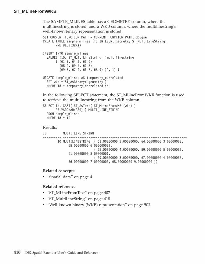
The SAMPLE_MLINES table has a GEOMETRY column, where themultilinestring is stored, and a WKB column, where the multilinestring’swell-known binary representation is stored.SET CURRENT FUNCTION PATH = CURRENT FUNCTION PATH, db2gseCREATE TABLE sample_mlines (id INTEGER, geometry ST_MultiLineString,
wkb BLOB(32K))
INSERT INTO sample_mlinesVALUES (10, ST_MultiLineString (’multilinestring
( (61 2, 64 3, 65 6),(58 4, 59 5, 61 8),(69 3, 67 4, 66 7, 68 9) )’, 1) )
UPDATE sample_mlines AS temporary_correlatedSET wkb = ST_AsBinary( geometry )WHERE id = temporary_correlated.id
In the following SELECT statement, the ST_MLineFromWKB function is usedto retrieve the multilinestring from the WKB column.SELECT id, CAST( ST_AsText( ST_MLineFromWKB (wkb) )
AS VARCHAR(280) ) MULTI_LINE_STRINGFROM sample_mlinesWHERE id = 10
Results:ID MULTI_LINE_STRING---------- --------------------------------------------------------------------
10 MULTILINESTRING (( 61.00000000 2.00000000, 64.00000000 3.00000000,65.00000000 6.00000000),
( 58.00000000 4.00000000, 59.00000000 5.00000000,61.00000000 8.0000000),
( 69.00000000 3.00000000, 67.00000000 4.00000000,66.00000000 7.00000000, 68.00000000 9.00000000 ))
Related concepts:
v “Spatial data” on page 4
Related reference:
v “ST_MLineFromText” on page 407v “ST_MultiLineString” on page 418v “Well-known binary (WKB) representation” on page 503
ST_MLineFromWKB
410 DB2 Spatial Extender User’s Guide and Reference

ST_MPointFromText
ST_MPointFromText takes a well-known text representation of a multipointand, optionally, a spatial reference system identifier as input parameters andreturns the corresponding multipoint.
If the given well-known text representation is null, then null is returned.
The recommended function for achieving the same result is the ST_MultiPointfunction. It is recommended because of its flexibility: ST_MultiPoint takesadditional forms of input as well as the well-known text representation.
Syntax:
�� db2gse.ST_MPointFromText ( wkt ), srs_id
��
Parameters:
wkt A value of type CLOB(2G) that contains the well-known textrepresentation of the resulting multipoint.
srs_id A value of type INTEGER that identifies the spatial reference systemfor the resulting multipoint.
If the srs_id parameter is omitted, the spatial reference system withthe numeric identifier 0 (zero) is used.
If the specified srs_id does not identify a spatial reference systemlisted in the catalog viewDB2GSE.ST_SPATIAL_REFERENCE_SYSTEMS, then an exceptioncondition is raised (SQLSTATE 38SU1).
Return type:
db2gse.ST_MultiPoint
Example:
In the following example, the lines of results have been reformatted forreadability. The spacing in your results will vary according to your onlinedisplay.
This example illustrates how ST_MPointFromText can be used to create andinsert a multipoint from its well-known text representation. The record that isinserted has ID = 1110, and the geometry is a multipoint in spatial referencesystem 1. The multipoint is in the well-known text representation of amultipoint. The X and Y coordinates for this geometry are: (1, 2) (4, 3) (5, 6).
ST_MPointFromText
Chapter 19. Spatial functions: syntax and parameters 411
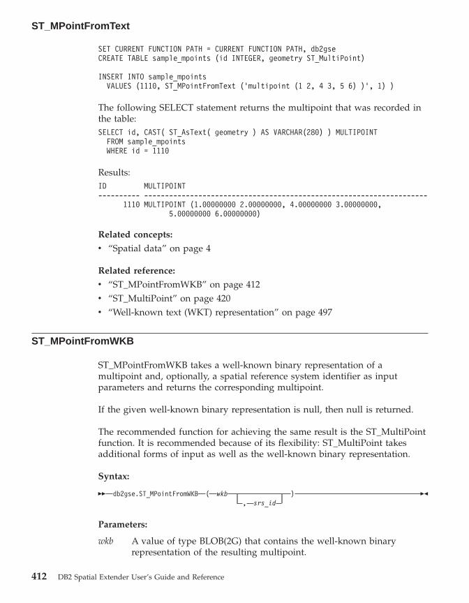
SET CURRENT FUNCTION PATH = CURRENT FUNCTION PATH, db2gseCREATE TABLE sample_mpoints (id INTEGER, geometry ST_MultiPoint)
INSERT INTO sample_mpointsVALUES (1110, ST_MPointFromText (’multipoint (1 2, 4 3, 5 6) )’, 1) )
The following SELECT statement returns the multipoint that was recorded inthe table:SELECT id, CAST( ST_AsText( geometry ) AS VARCHAR(280) ) MULTIPOINT
FROM sample_mpointsWHERE id = 1110
Results:ID MULTIPOINT---------- --------------------------------------------------------------------
1110 MULTIPOINT (1.00000000 2.00000000, 4.00000000 3.00000000,5.00000000 6.00000000)
Related concepts:
v “Spatial data” on page 4
Related reference:
v “ST_MPointFromWKB” on page 412v “ST_MultiPoint” on page 420v “Well-known text (WKT) representation” on page 497
ST_MPointFromWKB
ST_MPointFromWKB takes a well-known binary representation of amultipoint and, optionally, a spatial reference system identifier as inputparameters and returns the corresponding multipoint.
If the given well-known binary representation is null, then null is returned.
The recommended function for achieving the same result is the ST_MultiPointfunction. It is recommended because of its flexibility: ST_MultiPoint takesadditional forms of input as well as the well-known binary representation.
Syntax:
�� db2gse.ST_MPointFromWKB ( wkb ), srs_id
��
Parameters:
wkb A value of type BLOB(2G) that contains the well-known binaryrepresentation of the resulting multipoint.
ST_MPointFromText
412 DB2 Spatial Extender User’s Guide and Reference

srs_id A value of type INTEGER that identifies the spatial reference systemfor the resulting multipoint.
If the srs_id parameter is omitted, the spatial reference system withthe numeric identifier 0 (zero) is used.
If the specified srs_id does not identify a spatial reference systemlisted in the catalog viewDB2GSE.ST_SPATIAL_REFERENCE_SYSTEMS, then an exceptioncondition is raised (SQLSTATE 38SU1).
Return type:
db2gse.ST_MultiPoint
Example:
In the following example, the lines of results have been reformatted forreadability. The spacing in your results will vary according to your onlinedisplay.
This example illustrates how ST_MPointFromWKB can be used to create amultipoint from its well-known binary representation. The geometry is amultipoint in spatial reference system 1. In this example, the multipoint getsstored with ID = 10 in the GEOMETRY column of the SAMPLE_MPOINTStable, and then the WKB column is updated with its well-known binaryrepresentation (using the ST_AsBinary function). Finally, theST_MPointFromWKB function is used to return the multipoint from the WKBcolumn. The X and Y coordinates for this geometry are: (44, 14) (35, 16) (24,13).
The SAMPLE_MPOINTS table has a GEOMETRY column, where themultipoint is stored, and a WKB column, where the multipoint’s well-knownbinary representation is stored.SET CURRENT FUNCTION PATH = CURRENT FUNCTION PATH, db2gseCREATE TABLE sample_mpoints (id INTEGER, geometry ST_MultiPoint,
wkb BLOB(32K))
INSERT INTO sample_mpointsVALUES (10, ST_MultiPoint (’multipoint ( 4 14, 35 16, 24 13)’, 1))
UPDATE sample_mpoints AS temporary_correlatedSET wkb = ST_AsBinary( geometry )WHERE id = temporary_correlated.id
In the following SELECT statement, the ST_MPointFromWKB function is usedto retrieve the multipoint from the WKB column.
ST_MPointFromWKB
Chapter 19. Spatial functions: syntax and parameters 413

SELECT id, CAST( ST_AsText( ST_MLineFromWKB (wkb)) AS VARCHAR(100)) MULTIPOINTFROM sample_mpointsWHERE id = 10
Results:ID MULTIPOINT---------- --------------------------------------------------------------------
10 MULTIPOINT (44.00000000 14.00000000, 35.0000000016.00000000 24.00000000 13.00000000)
Related concepts:
v “Spatial data” on page 4
Related reference:
v “ST_MPointFromText” on page 411v “ST_MultiPoint” on page 420v “Well-known binary (WKB) representation” on page 503v “ST_Point” on page 437
ST_MPolyFromText
ST_MPolyFromText takes a well-known text representation of a multipolygonand, optionally, a spatial reference system identifier as input parameters andreturns the corresponding multipolygon.
If the given well-known text representation is null, then null is returned.
The recommended function for achieving the same result is theST_MultiPolygon function. It is recommended because of its flexibility:ST_MultiPolygon takes additional forms of input as well as the well-knowntext representation.
Syntax:
�� db2gse.ST_MPolyFromText ( wkt ), srs_id
��
Parameters:
wkt A value of type CLOB(2G) that contains the well-known textrepresentation of the resulting multipolygon.
srs_id A value of type INTEGER that identifies the spatial reference systemfor the resulting multipolygon.
ST_MPointFromWKB
414 DB2 Spatial Extender User’s Guide and Reference

If the srs_id parameter is omitted, the spatial reference system withthe numeric identifier 0 (zero) is used.
If the specified srs_id does not identify a spatial reference systemlisted in the catalog viewDB2GSE.ST_SPATIAL_REFERENCE_SYSTEMS, then an exceptioncondition is raised (SQLSTATE 38SU1).
Return type:
db2gse.ST_MultiPolygon
Example:
In the following example, the lines of results have been reformatted forreadability. The spacing in your results will vary according to your onlinedisplay.
This example illustrates how ST_MPolyFromText can be used to create andinsert a multipolygon from its well-known text representation. The record thatis inserted has ID = 1110, and the geometry is a multipolygon in spatialreference system 1. The multipolygon is in the well-known text representationof a multipolygon. The X and Y coordinates for this geometry are:v Polygon 1: (3, 3) (4, 6) (5, 3) (3, 3)v Polygon 2: (8, 24) (9, 25) (1, 28) (8, 24)v Polygon 3: (13, 33) (7, 36) (1, 40) (10, 43) (13, 33)SET CURRENT FUNCTION PATH = CURRENT FUNCTION PATH, db2gseCREATE TABLE sample_mpolys (id INTEGER, geometry ST_MultiPolygon)
INSERT INTO sample_mpolysVALUES (1110,
ST_MPolyFromText (’multipolygon (( (3 3, 4 6, 5 3, 3 3),(8 24, 9 25, 1 28, 8 24),(13 33, 7 36, 1 40, 10 43 13 33) ))’, 1) )
The following SELECT statement returns the multipolygon that was recordedin the table:SELECT id, CAST( ST_AsText( geometry ) AS VARCHAR(350) ) MULTI_POLYGON
FROM sample_mpolysWHERE id = 1110
Results:ID MULTI_POLYGON------- --------------------------------------------------------------------
1110 MULTIPOLYGON ((( 13.00000000 33.00000000, 10.00000000 43.00000000,1.00000000 40.00000000, 7.00000000 36.00000000,13.00000000 33.00000000)),
(( 8.00000000 24.00000000, 9.00000000 25.00000000,
ST_MPolyFromText
Chapter 19. Spatial functions: syntax and parameters 415
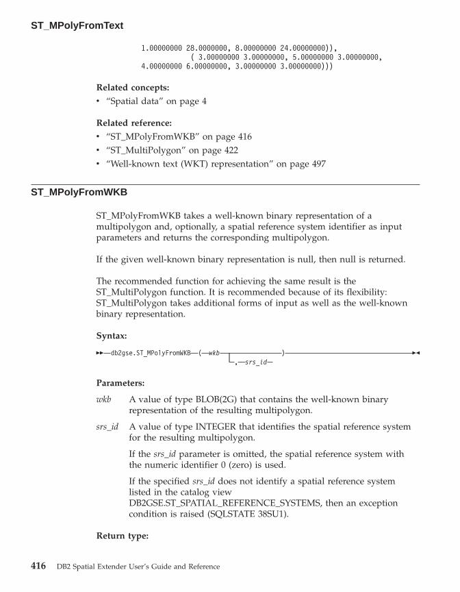
1.00000000 28.0000000, 8.00000000 24.00000000)),( 3.00000000 3.00000000, 5.00000000 3.00000000,
4.00000000 6.00000000, 3.00000000 3.00000000)))
Related concepts:
v “Spatial data” on page 4
Related reference:
v “ST_MPolyFromWKB” on page 416v “ST_MultiPolygon” on page 422v “Well-known text (WKT) representation” on page 497
ST_MPolyFromWKB
ST_MPolyFromWKB takes a well-known binary representation of amultipolygon and, optionally, a spatial reference system identifier as inputparameters and returns the corresponding multipolygon.
If the given well-known binary representation is null, then null is returned.
The recommended function for achieving the same result is theST_MultiPolygon function. It is recommended because of its flexibility:ST_MultiPolygon takes additional forms of input as well as the well-knownbinary representation.
Syntax:
�� db2gse.ST_MPolyFromWKB ( wkb ), srs_id
��
Parameters:
wkb A value of type BLOB(2G) that contains the well-known binaryrepresentation of the resulting multipolygon.
srs_id A value of type INTEGER that identifies the spatial reference systemfor the resulting multipolygon.
If the srs_id parameter is omitted, the spatial reference system withthe numeric identifier 0 (zero) is used.
If the specified srs_id does not identify a spatial reference systemlisted in the catalog viewDB2GSE.ST_SPATIAL_REFERENCE_SYSTEMS, then an exceptioncondition is raised (SQLSTATE 38SU1).
Return type:
ST_MPolyFromText
416 DB2 Spatial Extender User’s Guide and Reference

db2gse.ST_MultiPolygon
Example:
In the following example, the lines of results have been reformatted forreadability. The spacing in your results will vary according to your onlinedisplay.
This example illustrates how ST_MPolyFromWKB can be used to create amultipolygon from its well-known binary representation. The geometry is amultipolygon in spatial reference system 1. In this example, the multipolygongets stored with ID = 10 in the GEOMETRY column of the SAMPLE_MPOLYStable, and then the WKB column is updated with its well-known binaryrepresentation (using the ST_AsBinary function). Finally, theST_MPolyFromWKB function is used to return the multipolygon from theWKB column. The X and Y coordinates for this geometry are:v Polygon 1: (1, 72) (4, 79) (5, 76) (1, 72)v Polygon 2: (10, 20) (10, 40) (30, 41) (10, 20)v Polygon 3: (9, 43) (7, 44) (6, 47) (9, 43)
The SAMPLE_MPOLYS table has a GEOMETRY column, where themultipolygon is stored, and a WKB column, where the multipolygon’swell-known binary representation is stored.SET CURRENT FUNCTION PATH = CURRENT FUNCTION PATH, db2gseCREATE TABLE sample_mpolys (id INTEGER,
geometry ST_MultiPolygon, wkb BLOB(32K))
INSERT INTO sample_mpolysVALUES (10, ST_MultiPolygon (’multipolygon
(( (1 72, 4 79, 5 76, 1 72),(10 20, 10 40, 30 41, 10 20),(9 43, 7 44, 6 47, 9 43) ))’, 1))
UPDATE sample_mpolys AS temporary_correlatedSET wkb = ST_AsBinary( geometry )WHERE id = temporary_correlated.id
In the following SELECT statement, the ST_MPolyFromWKB function is usedto retrieve the multipolygon from the WKB column.SELECT id, CAST( ST_AsText( ST_MPolyFromWKB (wkb) )
AS VARCHAR(320) ) MULTIPOLYGONFROM sample_mpolysWHERE id = 10
Results:ID MULTIPOLYGON---------- --------------------------------------------------------------------
10 MULTIPOLYGON ((( 10.00000000 20.00000000, 30.00000000
ST_MPolyFromWKB
Chapter 19. Spatial functions: syntax and parameters 417

41.00000000, 10.00000000 40.00000000, 10.0000000020.00000000)),
( 1.00000000 72.00000000, 5.0000000076.00000000, 4.00000000 79.0000000, 1.0000000072,00000000)),
( 9.00000000 43.00000000, 6.0000000047.00000000, 7.00000000 44.00000000, 9.0000000043.00000000 )))
Related concepts:
v “Spatial data” on page 4
Related reference:
v “ST_MPolyFromText” on page 414v “ST_MultiPolygon” on page 422v “Well-known binary (WKB) representation” on page 503v “ST_Polygon” on page 449
ST_MultiLineString
ST_MultiLineString constructs a multilinestring from one of the followinginputs:v A well-known text representationv A well-known binary representationv A shape representationv A representation in the geography markup language (GML)
An optional spatial reference system identifier can be specified to identify thespatial reference system that the resulting multilinestring is in.
If the well-known text representation, the well-known binary representation,the shape representation, or the GML representation is null, then null isreturned.
Syntax:
�� db2gse.ST_MultiLineString ( wktwkbgmlshape
, srs_id) ��
Parameters:
wkt A value of type CLOB(2G) that contains the well-known textrepresentation of the resulting multilinestring.
wkb A value of type BLOB(2G) that contains the well-known binaryrepresentation of the resulting multilinestring.
ST_MPolyFromWKB
418 DB2 Spatial Extender User’s Guide and Reference

gml A value of type CLOB(2G) that represents the resulting multilinestringusing the geography markup language.
shape A value of type BLOB(2G) that represents the shape representation ofthe resulting multilinestring.
srs_id A value of type INTEGER that identifies the spatial reference systemfor the resulting multilinestring.
If the srs_id parameter is omitted, then the spatial reference systemwith the numeric identifier 0 (zero) is used.
If srs_id does not identify a spatial reference system listed in thecatalog view DB2GSE.ST_SPATIAL_REFERENCE_SYSTEMS, then anexception condition is raised (SQLSTATE 38SU1).
Return type:
db2gse.ST_MultiLineString
Example:
In the following example, the lines of results have been reformatted forreadability. The spacing in your results will vary according to your onlinedisplay.
This example illustrates how ST_MultiLineString can be used to create andinsert a multilinestring from its well-known text representation. The recordthat is inserted has ID = 1110, and the geometry is a multilinestring in spatialreference system 1. The multilinestring is in the well-known textrepresentation of a multilinestring. The X and Y coordinates for this geometryare:v Line 1: (33, 2) (34, 3) (35, 6)v Line 2: (28, 4) (29, 5) (31, 8) (43, 12)v Line 3: (39, 3) (37, 4) (36, 7)SET CURRENT FUNCTION PATH = CURRENT FUNCTION PATH, db2gseCREATE TABLE sample_mlines (id INTEGER,
geometry ST_MultiLineString)
INSERT INTO sample_mlinesVALUES (1110,
ST_MultiLineString (’multilinestring ( (33 2, 34 3, 35 6),(28 4, 29 5, 31 8, 43 12),(39 3, 37 4, 36 7) )’, 1) )
The following SELECT statement returns the multilinestring that was recordedin the table:
ST_MultiLineString
Chapter 19. Spatial functions: syntax and parameters 419

SELECT id,CAST( ST_AsText( geometry ) AS VARCHAR(280) )
MULTI_LINE_STRINGFROM sample_mlinesWHERE id = 1110
Results:ID MULTI_LINE_STRING------- --------------------------------------------------------------------
1110 MULTILINESTRING (( 33.00000000 2.00000000, 34.00000000 3.00000000,35.00000000 6.00000000),
( 28.00000000 4.00000000, 29.00000000 5.00000000,31.00000000 8.0000000, 43.00000000 12.00000000),
( 39.00000000 3.00000000, 37.00000000 4.00000000,36.00000000 7.00000000 ))
Related concepts:
v “Spatial data” on page 4
Related reference:
v “Well-known text (WKT) representation” on page 497v “Well-known binary (WKB) representation” on page 503v “Shape representation” on page 505v “Geography Markup Language (GML) representation” on page 505
ST_MultiPoint
ST_MultiPoint constructs a multipoint from one of the following inputs:v A well-known text representationv A well-known binary representationv A shape representationv A representation in the geography markup language (GML)
An optional spatial reference system identifier can be specified to indicate thespatial reference system the resulting multipoint is in.
If the well-known text representation, the well-known binary representation,the shape representation, or the GML representation is null, then null isreturned.
Syntax:
ST_MultiLineString
420 DB2 Spatial Extender User’s Guide and Reference
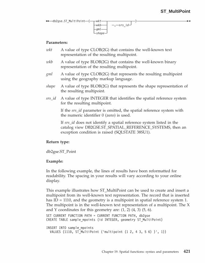
�� db2gse.ST_MultiPoint ( wktwkbgmlshape
, srs_id) ��
Parameters:
wkt A value of type CLOB(2G) that contains the well-known textrepresentation of the resulting multipoint.
wkb A value of type BLOB(2G) that contains the well-known binaryrepresentation of the resulting multipoint.
gml A value of type CLOB(2G) that represents the resulting multipointusing the geography markup language.
shape A value of type BLOB(2G) that represents the shape representation ofthe resulting multipoint.
srs_id A value of type INTEGER that identifies the spatial reference systemfor the resulting multipoint.
If the srs_id parameter is omitted, the spatial reference system withthe numeric identifier 0 (zero) is used.
If srs_id does not identify a spatial reference system listed in thecatalog view DB2GSE.ST_SPATIAL_REFERENCE_SYSTEMS, then anexception condition is raised (SQLSTATE 38SU1).
Return type:
db2gse.ST_Point
Example:
In the following example, the lines of results have been reformatted forreadability. The spacing in your results will vary according to your onlinedisplay.
This example illustrates how ST_MultiPoint can be used to create and insert amultipoint from its well-known text representation. The record that is insertedhas ID = 1110, and the geometry is a multipoint in spatial reference system 1.The multipoint is in the well-known text representation of a multipoint. The Xand Y coordinates for this geometry are: (1, 2) (4, 3) (5, 6).SET CURRENT FUNCTION PATH = CURRENT FUNCTION PATH, db2gseCREATE TABLE sample_mpoints (id INTEGER, geometry ST_MultiPoint)
INSERT INTO sample_mpointsVALUES (1110, ST_MultiPoint (’multipoint (1 2, 4 3, 5 6) )’, 1))
ST_MultiPoint
Chapter 19. Spatial functions: syntax and parameters 421
The following SELECT statement returns the multipoint that was recorded inthe table:SELECT id, CAST( ST_AsText(geometry) AS VARCHAR(90)) MULTIPOINT
FROM sample_mpointsWHERE id = 1110
Results:ID MULTIPOINT---------- -----------------------------------------------------
1110 MULTIPOINT (1.00000000 2.00000000, 4.000000003.00000000, 5.00000000 6.00000000)
Related concepts:
v “Spatial data” on page 4
Related reference:
v “Well-known text (WKT) representation” on page 497v “Well-known binary (WKB) representation” on page 503v “Shape representation” on page 505v “Geography Markup Language (GML) representation” on page 505
ST_MultiPolygon
ST_MultiPolygon constructs a multipolygon from one of the following inputs:v A well-known text representationv A well-known binary representationv A shape representationv A representation in the geography markup language (GML)
An optional spatial reference system identifier can be specified to identify thespatial reference system that the resulting multipolygon is in.
If the well-known text representation, the well-known binary representation,the shape representation, or the GML representation is null, then null isreturned.
Syntax:
�� db2gse.ST_MultiPolygon wktwkbshapegml
, srs_id) ��
Parameters:
ST_MultiPoint
422 DB2 Spatial Extender User’s Guide and Reference
wkt A value of type CLOB(2G) that contains the well-known textrepresentation of the resulting multipolygon.
wkb A value of type BLOB(2G) that contains the well-known binaryrepresentation of the resulting multipolygon.
gml A value of type CLOB(2G) that represents the resulting multipolygonusing the geography markup language.
shape A value of type BLOB(2G) that represents the shape representation ofthe resulting multipolygon.
srs_id A value of type INTEGER that identifies the spatial reference systemfor the resulting multipolygon.
If the srs_id parameter is omitted, the spatial reference system withthe numeric identifier 0 (zero) is used.
If srs_id does not identify a spatial reference system listed in thecatalog view DB2GSE.ST_SPATIAL_REFERENCE_SYSTEMS, then anexception condition is raised (SQLSTATE 38SU1).
Return type:
db2gse.ST_MultiPolygon
Example:
In the following example, the lines of results have been reformatted forreadability. The spacing in your results will vary according to your onlinedisplay.
This example illustrates how ST_MultiPolygon can be used to create andinsert a multipolygon from its well-known text representation. The record thatis inserted has ID = 1110, and the geometry is a multipolygon in spatialreference system 1. The multipolygon is in the well-known text representationof a multipolygon. The X and Y coordinates for this geometry are:v Polygon 1: (3, 3) (4, 6) (5, 3) (3, 3)v Polygon 2: (8, 24) (9, 25) (1, 28) (8, 24)v Polygon 3: (13, 33) (7, 36) (1, 40) (10, 43) (13, 33)SET CURRENT FUNCTION PATH = CURRENT FUNCTION PATH, db2gseCREATE TABLE sample_mpolys (id INTEGER, geometry ST_MultiPolygon)
INSERT INTO sample_mpolysVALUES (1110,
ST_MultiPolygon (’multipolygon (( (3 3, 4 6, 5 3, 3 3),(8 24, 9 25, 1 28, 8 24),(13 33, 7 36, 1 40, 10 43 13 33) ))’, 1) )
ST_MultiPolygon
Chapter 19. Spatial functions: syntax and parameters 423

The following SELECT statement returns the multipolygon that was recordedin the table:SELECT id, CAST( ST_AsText( geometry ) AS VARCHAR(350) ) MULTI_POLYGON
FROM sample_mpolysWHERE id = 1110
Results:ID MULTI_POLYGON------- --------------------------------------------------------------------
1110 MULTIPOLYGON ((( 13.00000000 33.00000000, 10.00000000 43.00000000,1.00000000 40.00000000, 7.00000000 36.00000000,13.00000000 33.00000000)),
(( 8.00000000 24.00000000, 9.00000000 25.00000000,1.00000000 28.0000000, 8.00000000 24.00000000)),
(( 3.00000000 3.00000000, 5.00000000 3.00000000,4.00000000 6.00000000, 3.00000000 3.00000000)))
Related concepts:
v “Spatial data” on page 4
Related reference:
v “Well-known text (WKT) representation” on page 497v “Well-known binary (WKB) representation” on page 503v “Shape representation” on page 505v “Geography Markup Language (GML) representation” on page 505
ST_NumGeometries
ST_NumGeometries takes a geometry collection as an input parameter andreturns the number of geometries in the collection.
If the given geometry collection is null or is empty, then null is returned.
This function can also be called as a method.
Syntax:
�� db2gse.ST_NumGeometries ( collection ) ��
Parameter:
collectionA value of type ST_GeomCollection or one of its subtypes thatrepresents the geometry collection for which the number ofgeometries is returned.
ST_MultiPolygon
424 DB2 Spatial Extender User’s Guide and Reference

Return Type:
INTEGER
Example:
Two geometry collections are stored in the SAMPLE_GEOMCOLL table. Oneis a multipolygon, and the other is a multipoint. The ST_NumGeometriesfunction determines how many individual geometries are within eachgeometry collection.SET CURRENT FUNCTION PATH = CURRENT FUNCTION PATH, db2gseCREATE TABLE sample_geomcoll (id INTEGER, geometry ST_GeomCollection)
INSERT INTO sample_geomcollVALUES (1,
ST_MultiPolygon (’multipolygon (( (3 3, 4 6, 5 3, 3 3),(8 24, 9 25, 1 28, 8 24),(13 33, 7 36, 1 40, 10 43, 13 33) ))’, 1) )
INSERT INTO sample_geomcollVALUES (2, ST_MultiPoint (’multipoint (1 2, 4 3, 5 6, 7 6, 8 8)’, 1) )
SELECT id, ST_NumGeometries (geometry) NUM_GEOMS_IN_COLLFROM sample_geomcoll
Results:ID NUM_GEOMS_IN_COLL----------- -----------------
1 32 5
Related reference:
v “ST_GeometryN” on page 353
ST_NumInteriorRing
ST_NumInteriorRing takes a polygon as an input parameter and returns thenumber of its interior rings.
If the given polygon is null or is empty, then null is returned.
If the polygon has no interior rings, then 0 (zero) is returned.
This function can also be called as a method.
Syntax:
ST_NumGeometries
Chapter 19. Spatial functions: syntax and parameters 425

�� db2gse.ST_NumInteriorRing ( polygon ) ��
Parameter:
polygonA value of type ST_Polygon that represents the polygon for which thenumber of interior rings is returned.
Return type:
INTEGER
Example:
The following example creates two polygons:v One with two interior ringsv One without any interior ringsSET CURRENT FUNCTION PATH = CURRENT FUNCTION PATH, db2gseCREATE TABLE sample_polys (id INTEGER, geometry ST_Polygon)
INSERT INTO sample_polysVALUES (1, ST_Polygon(’polygon
((40 120, 90 120, 90 150, 40 150, 40 120),(50 130, 60 130, 60 140, 50 140, 50 130),(70 130, 80 130, 80 140, 70 140, 70 130))’ , 0) )
INSERT INTO sample_polysVALUES (2, ST_Polygon(’polygon ((5 15, 50 15, 50 105, 5 15))’ , 0) )
The ST_NumInteriorRing function is used to return the number of rings in thegeometries in the table:SELECT id, ST_NumInteriorRing(geometry) NUM_RINGSFROM sample_polys
Results:ID NUM_RINGS---------- ---------------
1 22 0
Related reference:
v “ST_InteriorRingN” on page 361
ST_NumInteriorRing
426 DB2 Spatial Extender User’s Guide and Reference

ST_NumLineStrings
ST_NumLineStrings takes a multilinestring as an input parameter and returnsthe number of linestrings that it contains.
If the given multilinestring is null or is empty, then null is returned.
This function can also be called as a method.
Syntax:
�� db2gse.ST_NumLineStrings ( multilinestring ) ��
Parameter:
multilinestringA value of type ST_MultiLineString that represents the multilinestringfor which the number of linestrings is returned.
Return type:
INTEGER
Example:
Multilinestrings are stored in the SAMPLE_MLINES table. TheST_NumLineStrings function determines how many individual geometries arewithin each multilinestring.SET CURRENT FUNCTION PATH = CURRENT FUNCTION PATH, db2gseCREATE TABLE sample_mlines (id INTEGER, geometry ST_MultiLineString)
INSERT INTO sample_mlinesVALUES (110, ST_MultiLineString (’multilinestring
( (33 2, 34 3, 35 6),(28 4, 29 5, 31 8, 43 12),(39 3, 37 4, 36 7))’, 1) )
INSERT INTO sample_mlinesVALUES (111, ST_MultiLineString (’multilinestring
( (3 2, 4 3, 5 6),(8 4, 9 5, 3 8, 4 12))’, 1) )
SELECT id, ST_NumLineStrings (geometry) NUM_WITHINFROM sample_mlines
Results:ID NUM_WITHIN----------- ----------
110 3111 2
ST_NumLineStrings
Chapter 19. Spatial functions: syntax and parameters 427
Related reference:
v “ST_LineStringN” on page 383
ST_NumPoints
ST_NumPoints takes a geometry as an input parameter and returns thenumber of points that were used to define that geometry. For example, if thegeometry is a polygon and five points were used to define that polygon, thenthe returned number is 5.
If the given geometry is null or is empty, then null is returned.
This function can also be called as a method.
Syntax:
�� db2gse.ST_NumPoints ( geometry ) ��
Parameter:
geometryA value of type ST_Geometry or one of its subtypes that representsthe geometry for which the number of points is returned.
Return type:
INTEGER
Example:
A variety of geometries are stored in the table. The ST_NumPoints functiondetermines how many points are within each geometry in theSAMPLE_GEOMETRIES table.SET CURRENT FUNCTION PATH = CURRENT FUNCTION PATH, db2gseCREATE TABLE sample_geometries (spatial_type VARCHAR(18), geometry ST_Geometry)
INSERT INTO sample_geometriesVALUES (’st_point’,
ST_Point (2, 3, 0) )
INSERT INTO sample_geometriesVALUES (’st_linestring’,
ST_LineString (’linestring (2 5, 21 3, 23 10)’, 0) )
INSERT INTO sample_geometriesVALUES (’st_polygon’,
ST_NumLineStrings
428 DB2 Spatial Extender User’s Guide and Reference

ST_Polygon (’polygon ((110 120, 110 140, 120 130, 110 120))’, 0) )
SELECT spatial_type, ST_NumPoints (geometry) NUM_POINTSFROM sample_geometries
Results:SPATIAL_TYPE NUM_POINTS--------------- ----------st_point 1st_linestring 3st_polygon 4
Related reference:
v “ST_PointN” on page 443
ST_NumPolygons
ST_NumPolygons takes a multipolygon as an input parameter and returns thenumber of polygons that it contains.
If the given multipolygon is null or is empty, then null is returned.
This function can also be called as a method.
Syntax:
�� db2gse.ST_NumPolygons ( multipolygon ) ��
Parameter:
multipolygonA value of type ST_MultiPolygon that represents the multipolygon forwhich the number of polygons is returned.
Return type:
INTEGER
Example:
Multipolygons are stored in the SAMPLE_MPOLYS table. TheST_NumPolygons function determines how many individual geometries arewithin each multipolygon.SET CURRENT FUNCTION PATH = CURRENT FUNCTION PATH, db2gseCREATE TABLE sample_mpolys (id INTEGER, geometry ST_MultiPolygon)
INSERT INTO sample_mpolysVALUES (1,
ST_NumPoints
Chapter 19. Spatial functions: syntax and parameters 429

ST_MultiPolygon (’multipolygon (( (3 3, 4 6, 5 3, 3 3),(8 24, 9 25, 1 28, 8 24),(13 33, 7 36, 1 40, 10 43, 13 33) ))’, 1) )
INSERT INTO sample_polysVALUES (2,
ST_MultiPolygon (’multipolygon empty’, 1) )
INSERT INTO sample_polysVALUES (3,
ST_MultiPolygon (’multipolygon (( (3 3, 4 6, 5 3, 3 3),(13 33, 7 36, 1 40, 10 43, 13 33) ))’, 1) )
SELECT id, ST_NumPolygons (geometry) NUM_WITHINFROM sample_mpolys
Results:ID NUM_WITHIN----------- ----------
1 32 03 2
Related reference:
v “ST_PolygonN” on page 452
ST_Overlaps
ST_Overlaps takes two geometries as input parameters and returns 1 if theintersection of the geometries results in a geometry of the same dimension butis not equal to either of the given geometries. Otherwise, 0 (zero) is returned.
If any of the two geometries is null or is empty, then null is returned.
If the second geometry is not represented in the same spatial reference systemas the first geometry, it will be converted to the other spatial reference system.
Syntax:
�� db2gse.ST_Overlaps ( geometry1 , geometry2 ) ��
Parameters:
geometry1A value of type ST_Geometry or one of its subtypes that representsthe geometry that is tested to overlap with geometry2.
ST_NumPolygons
430 DB2 Spatial Extender User’s Guide and Reference

geometry2A value of type ST_Geometry or one of its subtypes that representsthe geometry that is tested to overlap with geometry1.
Return type:
INTEGER
Examples:
These examples illustrate the use of ST_Overlaps. Various geometries arecreated and inserted into the SAMPLE_GEOMETRIES tableSET CURRENT FUNCTION PATH = CURRENT FUNCTION PATH, db2gseCREATE TABLE sample_geometries (id INTEGER, geometry ST_Geometry)
INSERT INTO sample_geometriesVALUES (1, ST_Point (10, 20, 1)),
(2, ST_Point (’point (41 41)’, 1) ),(10, ST_LineString (’linestring (1 10, 3 12, 10 10)’, 1) ),(20, ST_LineString (’linestring (50 10, 50 12, 45 10)’, 1) ),(30, ST_LineString (’linestring (50 12, 50 10, 60 8)’, 1) ),(100, ST_Polygon (’polygon ((0 0, 0 40, 40 40, 40 0, 0 0))’, 1) ),(110, ST_Polygon (’polygon ((30 10, 30 30, 50 30, 50 10, 30 10))’, 1) ),(120, ST_Polygon (’polygon ((0 50, 0 60, 40 60, 40 60, 0 50))’, 1) )
Example 1:
This example finds the IDs of points that overlap.SELECT sg1.id, sg2.id
CASE ST_Overlaps (sg1.geometry, sg2.geometry)WHEN 0 THEN ’Points_do_not_overlap’WHEN 1 THEN ’Points_overlap’END
AS OVERLAPFROM sample_geometries sg1, sample_geometries sg2WHERE sg1.id < 10 AND sg2.id < 10 AND sg1.id >= sg2.id
Results:ID ID OVERLAP----------- ---------- ------------------------
1 1 Points_do_not_overlap2 1 Points_do_not_overlap2 2 Points_do_not_overlap
Example 2:
This example finds the IDs of lines that overlap.SELECT sg1.id, sg2.id
CASE ST_Overlaps (sg1.geometry, sg2.geometry)WHEN 0 THEN ’Lines_do_not_overlap’WHEN 1 THEN ’Lines_overlap’
ST_Overlaps
Chapter 19. Spatial functions: syntax and parameters 431
ENDAS OVERLAPFROM sample_geometries sg1, sample_geometries sg2WHERE sg1.id >= 10 AND sg1.id < 100
AND sg2.id >= 10 AND sg2.id < 100AND sg1.id >= sg2.id
Results:ID ID OVERLAP----------- ---------- ------------------------
10 10 Lines_do_not_overlap20 10 Lines_do_not_overlap30 10 Lines_do_not_overlap20 20 Lines_do_not_overlap30 20 Lines_overlap30 30 Lines_do_not_overlap
Example 3:
This example finds the IDs of polygons that overlap.SELECT sg1.id, sg2.idCASE ST_Overlaps (sg1.geometry, sg2.geometry)WHEN 0 THEN ’Polygons_do_not_overlap’WHEN 1 THEN ’Polygons_overlap’END
AS OVERLAPFROM sample_geometries sg1, sample_geometries sg2WHERE sg1.id >= 100 AND sg2.id >= 100 AND sg1.id >= sg2.id
Results:ID ID OVERLAP----------- ---------- ------------------------
100 100 Polygons_do_not_overlap110 100 Polygons_overlap120 100 Polygons_do_not_overlap110 110 Polygons_do_not_overlap120 110 Polygons_do_not_overlap120 120 Polygons_do_not_overlap
Related reference:
v “Rules for using grid indexes to optimize spatial functions” on page 121
ST_Perimeter
ST_Perimeter takes a surface or multisurface and, optionally, a unit as inputparameters and returns the perimeter of the surface or multisurface, that isthe length of its boundary, measured in the given units.
If the given surface or multisurface is null or is empty, then null is returned.
ST_Overlaps
432 DB2 Spatial Extender User’s Guide and Reference

This function can also be called as a method.
Syntax:
�� db2gse.ST_Perimeter ( surface ), unit
��
Parameters:
surface A value of type ST_Surface, ST_MultiSurface, or one of their subtypesfor which the perimeter is returned.
unit A VARCHAR(128) value that identifies the units in which theperimeter is measured. The supported units of measure are listed inthe DB2GSE.ST_UNITS_OF_MEASURE catalog view.
If the unit parameter is omitted, the following rules are used todetermine the unit in which the perimeter is measured:v If surface is in a projected or geocentric coordinate system, the linear
unit associated with this coordinate system is used.v If surface is in a geographic coordinate system, the angular unit
associated with this coordinate system is used.
If the surface is in an unspecified coordinate system and the unit parameter isspecified, or if the surface is in a geographic coordinate system and a linearunit is specified, then an exception condition is raised (SQLSTATE 38SU4).
Return type:
DOUBLE
Examples:
These examples illustrate the use of the ST_Perimeter function. A spatialreference system with an ID of 4000 is created using a call to db2se, and apolygon is created in that spatial reference system.SET CURRENT FUNCTION PATH = CURRENT FUNCTION PATH, db2gse
db2se create_srs se_bank -srsId 4000 -srsName new_york1983-xOffset 0 -yOffset 0 -xScale 1 -yScale 1-coordsysName NAD_1983_StatePlane_New_York_East_FIPS_3101_Feet
The SAMPLE_POLYS table is created to hold a geometry with a perimeter of18.CREATE TABLE sample_polys (id SMALLINT, geometry ST_Polygon)
INSERT INTO sample_polysVALUES (1, ST_Polygon (’polygon ((0 0, 0 4, 5 4, 5 0, 0 0))’, 4000))
ST_Perimeter
Chapter 19. Spatial functions: syntax and parameters 433
Example 1:
This example lists the ID and perimeter of the polygon.SELECT id, ST_Perimeter (geometry) AS PERIMETER
FROM sample_polys
Results:ID PERIMETER----------- ------------------------
1 +1.80000000000000E+001
Example 2:
This example lists the ID and perimeter of the polygon with the perimetermeasured in meters.SELECT id, ST_Perimeter (geometry, ’METER’) AS PERIMETER_METER
FROM sample_polys
Results:ID PERIMETER_METER----------- ------------------------
1 +5.48641097282195E+000
ST_PerpPoints
ST_PerpPoints takes a curve or multicurve and a point as input parametersand returns the perpendicular projection of the given point on the curve ormulticurve. The point with the smallest distance between the given point andthe perpendicular point is returned. If two or more such perpendicularprojected points are equidistant from the given point, they are all returned. Ifno perpendicular point can be constructed, then an empty point is returned.
If the given curve or multicurve has Z or M coordinates, the Z or Mcoordinate of the resulting points are computed by interpolation on the givencurve or multicurve.
If the given curve or point is empty, then an empty point is returned. If thegiven curve or point is null , then null is returned.
This function can also be called as a method.
Syntax:
�� db2gse.ST_PerpPoints ( curve , point ) ��
Parameters:
ST_Perimeter
434 DB2 Spatial Extender User’s Guide and Reference

curve A value of type ST_Curve, ST_MultiCurve, or one of their subtypesthat represents the curve or multicurve in which the perpendicularprojection of the point is returned.
point A value of type ST_Point that represents the point that isperpendicular projected onto curve.
Return type:
db2gse.ST_MultiPoint
Examples:
These examples illustrate the use of the ST_PerpPoints function to find pointsthat are perpendicular to the linestring stored in the following table. TheST_LineString function is used in the INSERT statement to create thelinestring.SET CURRENT FUNCTION PATH = CURRENT FUNCTION PATH, db2gseCREATE TABLE sample_lines (id INTEGER, line ST_LineString)
INSERT INTO sample_lines (id, line)VALUES (1, ST_LineString(’linestring (0 10, 0 0, 10 0, 10 10)’ , 0) )
Example 1:
This example finds the perpendicular projection on the linestring of a pointwith coordinates (5, 0). The ST_AsText function is used to convert thereturned value (a multipoint) to its well-known text representation.SELECT CAST ( ST_AsText( ST_PerpPoints( line, ST_Point(5, 0) ) )AS VARCHAR(50) ) PERPFROM sample_lines
Results:PERP----------------------------------------MULTIPOINT ( 5.00000000 0.00000000)
Example 2:
This example finds the perpendicular projections on the linestring of a pointwith coordinates (5, 5). In this case, there are three points on the linestringthat are equidistant to the given location. Therefore, a multipoint that consistsof all three points is returned.SELECT CAST ( ST_AsText( ST_PerpPoints( line, ST_Point(5, 5) ) )AS VARCHAR160) ) PERPFROM sample_lines
Results:
ST_PerpPoints
Chapter 19. Spatial functions: syntax and parameters 435

PERP----------------------------------------------------------------------------------MULTIPOINT ( 0.00000000 5.00000000, 5.00000000 0.00000000, 10.00000000 5.00000000)
Example 3:
This example finds the perpendicular projections on the linestring of a pointwith coordinates (5, 10). In this case there are three different perpendicularpoints that can be found. However, the ST_PerpPoints function only returnsthose points that are closest to the given point. Thus, a multipoint thatconsists of only the two closest points is returned. The third point is notincluded.SELECT CAST ( ST_AsText( ST_PerpPoints( line, ST_Point(5, 10) ) )AS VARCHAR(80) ) PERPFROM sample_lines
Results:PERP--------------------------------------------------------------MULTIPOINT ( 0.00000000 10.00000000, 10.00000000 10.00000000 )
Example 4:
This example finds the perpendicular projection on the linestring of a pointwith coordinates (5, 15).SELECT CAST ( ST_AsText( ST_PerpPoints( line, ST_Point(’point(5 15)’, 0 ) ) )AS VARCHAR(80) ) PERPFROM sample_lines
Results:PERP------------------------------------MULTIPOINT ( 5.00000000 0.00000000 )
Example 5:
In this example, the specified point with coordinates (15 15) has noperpendicular projection on the linestring. Therefore, an empty geometry isreturned.SELECT CAST ( ST_AsText( ST_PerpPoints( line, ST_Point(15, 15) ) )AS VARCHAR(80) ) PERPFROM sample_lines
Results:PERP----------------------------------------------MULTIPOINT EMPTY
ST_PerpPoints
436 DB2 Spatial Extender User’s Guide and Reference

ST_Point
ST_Point constructs a point from one of the following sets of input:v X and Y coordinates onlyv X, Y, and Z coordinatesv X, Y, Z, and M coordinatesv A well-known text representationv A well-known binary representationv A shape representationv A representation in the geography markup language (GML)
An optional spatial reference system identifier can be specified to indicate thespatial reference system that the resulting point is in.
If the point is constructed from coordinates, and if the X or Y coordinate isnull, then an exception condition is raised (SQLSTATE 38SUP). If the Z or Mcoordinate is null, then the resulting point will not have a Z or M coordinate,respectively. If the point is constructed from its well-known textrepresentation, its well-known binary representation, its shape representation,or its GML representation, and if the representation is null, then null isreturned.
Syntax:
�� db2gse.ST_Point ( coordinateswktwkbgmlshape
, srs_id) ��
coordinates:
x_coordinate , y_coordinate, z_coordinate
, m_coordinate
Parameters:
wkt A value of type CLOB(2G) that contains the well-known textrepresentation of the resulting point.
wkb A value of type BLOB(2G) that contains the well-known binaryrepresentation of the resulting point.
gml A value of type CLOB(2G) that represents the resulting point usingthe geography markup language.
ST_Point
Chapter 19. Spatial functions: syntax and parameters 437

shape A value of type BLOB(2G) that represents the shape representation ofthe resulting point.
srs_id A value of type INTEGER that identifies the spatial reference systemfor the resulting point.
If the srs_id parameter is omitted, the spatial reference system withthe numeric identifier 0 (zero) is used.
If srs_id does not identify a spatial reference system listed in thecatalog view DB2GSE.ST_SPATIAL_REFERENCE_SYSTEMS, then anexception condition is raised (SQLSTATE 38SU1).
x_coordinateA value of type DOUBLE that specifies the X coordinate for theresulting point.
y_coordinateA value of type DOUBLE that specifies the Y coordinate for theresulting point.
z_coordinateA value of type DOUBLE that specifies the Z coordinate for theresulting point.
If the z_coordinate parameter is omitted, the resulting point will nothave a Z coordinate. The result of ST_Is3D is 0 (zero) for such a point.
m_coordinateA value of type DOUBLE that specifies the M coordinate for theresulting point.
If the m_coordinate parameter is omitted, the resulting point will nothave a measure. The result of ST_IsMeasured is 0 (zero) for such apoint.
Return type:
db2gse.ST_Point
Example:
In the following examples, the lines of results have been reformatted forreadability. The spacing in your results will vary according to your onlinedisplay.
Example 1:
ST_Point
438 DB2 Spatial Extender User’s Guide and Reference

This example illustrates how ST_Point can be used to create and insert points.The first point is created using a set of X and Y coordinates. The second pointis created using its well-known text representation. Both points are geometriesin spatial reference system 1.SET CURRENT FUNCTION PATH = CURRENT FUNCTION PATH, db2gseCREATE TABLE sample_points (id INTEGER, geometry ST_Point)
INSERT INTO sample_pointsVALUES (1100, ST_Point (10, 20, 1) )
INSERT INTO sample_pointsVALUES (1101, ST_Point (’point (30 40)’, 1) )
The following SELECT statement returns the points that were recorded in thetable:SELECT id, CAST( ST_AsText( geometry ) AS VARCHAR(90)) POINTS
FROM sample_points
Results:ID POINTS---------- ------------------------------------
1110 POINT ( 10.00000000 20.00000000)1101 POINT ( 30.00000000 40.00000000)
Example 2:
This example inserts a record into the SAMPLE_POINTS table with ID 1103and a point value with an X coordinate of 120, a Y coordinate of 358, an Mcoordinate of 34, but no Z coordinate.INSERT INTO SAMPLE_POINTS(ID, GEOMETRY)VALUES(1103, db2gse.ST_Point(120, 358, CAST(NULL AS DOUBLE), 34, 1))SELECT id, CAST( ST_AsText( geometry ) AS VARCHAR(90) ) POINTSFROM sample_points
Results:ID POINTS---------- ------------------------------------------------
1103 POINT M ( 120.0000000 358.0000000 34.00000000)
Example 3:
This example inserts a row into the SAMPLE_POINTS table with ID 1104 anda point value with an X coordinate of 1003, a Y coordinate of 9876, a Zcoordinate of 20, and in spatial reference system 0, using the geographymarkup language for its representation.
ST_Point
Chapter 19. Spatial functions: syntax and parameters 439

INSERT INTO SAMPLE_POINTS(ID, GEOMETRY)VALUES(1104, db2gse.ST_Point(’<gml:Point><gml:coord>
<gml:x>1003</gml:X><gml:Y>9876</gml:Y><gml:Z>20</gml:Z></gml:coord></gml:Point>’, 1))
SELECT id, CAST( ST_AsText( geometry ) AS VARCHAR(90) ) POINTSFROM sample_points
Results:ID POINTS---------- ----------------------------------------------------
1104 POINT Z ( 1003.000000 9876.000000 20.00000000)
Related concepts:
v “Spatial data” on page 4
Related reference:
v “ST_Is3d” on page 366v “ST_IsMeasured” on page 371v “Well-known text (WKT) representation” on page 497v “Well-known binary (WKB) representation” on page 503v “Shape representation” on page 505v “Geography Markup Language (GML) representation” on page 505
ST_PointFromText
ST_PointFromText takes a well-known text representation of a point and,optionally, a spatial reference system identifier as input parameters andreturns the corresponding point.
If the given well-known text representation is null, then null is returned.
The recommended function for achieving the same result is the ST_Pointfunction. It is recommended because of its flexibility: ST_Point takesadditional forms of input as well as the well-known text representation.
Syntax:
�� db2gse.ST_PointFromText ( wkt ), srs_id
��
Parameters:
wkt A value of type CLOB(2G) that contains the well-known textrepresentation of the resulting point.
ST_Point
440 DB2 Spatial Extender User’s Guide and Reference

srs_id A value of type INTEGER that identifies the spatial reference systemfor the resulting point.
If the srs_id parameter is omitted, the spatial reference system withthe numeric identifier 0 (zero) is used.
If srs_id does not identify a spatial reference system listed in thecatalog view DB2GSE.ST_SPATIAL_REFERENCE_SYSTEMS, then anexception condition is raised (SQLSTATE 38SU1).
Return type:
db2gse.ST_Point
Example:
This example illustrates how ST_PointFromText can be used to create andinsert a point from its well-known text representation. The record that isinserted has ID = 1110, and the geometry is a point in spatial reference system1. The point is in the well-known text representation of a point. The X and Ycoordinates for this geometry are: (10, 20).SET CURRENT FUNCTION PATH = CURRENT FUNCTION PATH, db2gseCREATE TABLE sample_points (id INTEGER, geometry ST_Point)
INSERT INTO sample_pointsVALUES (1110, ST_PointFromText (’point (30 40)’, 1) )
The following SELECT statement returns the polygon that was recorded in thetable:SELECT id, CAST( ST_AsText( geometry ) AS VARCHAR(35) ) POINTS
FROM sample_pointsWHERE id = 1110
Results:ID POINTS---------- ---------------------------------------
1110 POINTS ( 30.00000000 40.00000000)
Related concepts:
v “Spatial data” on page 4
Related reference:
v “ST_Point” on page 437v “ST_PointFromWKB” on page 442
ST_PointFromText
Chapter 19. Spatial functions: syntax and parameters 441

ST_PointFromWKB
ST_PointFromWKB takes a well-known binary representation of a point and,optionally, a spatial reference system identifier as input parameters andreturns the corresponding point.
If the given well-known binary representation is null, then null is returned.
The recommended function for achieving the same result is the ST_Pointfunction. It is recommended because of its flexibility: ST_Point takesadditional forms of input as well as the well-known binary representation.
Syntax:
�� db2gse.ST_PointFromWKB ( wkb ), srs_id
��
Parameters:
wkb A value of type BLOB(2G) that contains the well-known binaryrepresentation of the resulting point.
srs_id A value of type INTEGER that identifies the spatial reference systemfor the resulting point.
If the srs_id parameter is omitted, the spatial reference system withthe numeric identifier 0 (zero) is used implicitly.
If srs_id does not identify a spatial reference system listed in thecatalog view DB2GSE.ST_SPATIAL_REFERENCE_SYSTEMS, then anexception condition is raised (SQLSTATE 38SU1).
Return type:
db2gse.ST_Point
Example:
This example illustrates how ST_PointFromWKB can be used to create a pointfrom its well-known binary representation. The geometries are points inspatial reference system 1. In this example, the points get stored in theGEOMETRY column of the SAMPLE_POLYS table, and then the WKB columnis updated with their well-known binary representations (using theST_AsBinary function). Finally, the ST_PointFromWKB function is used toreturn the points from the WKB column.
ST_PointFromWKB
442 DB2 Spatial Extender User’s Guide and Reference

The SAMPLE_POINTS table has a GEOMETRY column, where the points arestored, and a WKB column, where the points’ well-known binaryrepresentations are stored.SET CURRENT FUNCTION PATH = CURRENT FUNCTION PATH, db2gseCREATE TABLE sample_points (id INTEGER, geometry ST_Point, wkb BLOB(32K))
INSERT INTO sample_pointsVALUES (10, ST_Point (’point (44 14)’, 1) ),VALUES (11, ST_Point (’point (24 13)’, 1))
UPDATE sample_points AS temporary_correlatedSET wkb = ST_AsBinary( geometry )WHERE id = temporary_correlated.id
In the following SELECT statement, the ST_PointFromWKB function is usedto retrieve the points from the WKB column.SELECT id, CAST( ST_AsText( ST_PolyFromWKB (wkb) ) AS VARCHAR(35) ) POINTS
FROM sample_points
Results:ID POINTS---------- -----------------------------------
10 POINT ( 44.00000000 14.00000000)11 POINT ( 24.00000000 13.00000000)
Related concepts:
v “Spatial data” on page 4
Related reference:
v “ST_Point” on page 437v “ST_PointFromText” on page 440
ST_PointN
ST_PointN takes a linestring or a multipoint and an index as input parametersand returns that point in the linestring or multipoint that is identified by theindex. The resulting point is represented in the spatial reference system of thegiven linestring or multipoint.
If the given linestring or multipoint is null or is empty, then null is returned.If the index is smaller than 1 or larger than the number of points in thelinestring or multipoint, then null is returned and a warning condition isreturned (SQLSTATE 01HS2).
This function can also be called as a method.
ST_PointFromWKB
Chapter 19. Spatial functions: syntax and parameters 443

Syntax:
�� db2gse.ST_PointN ( geometry , index ) ��
Parameters:
geometryA value of type ST_LineString or ST_MultiPoint that represents thegeometry from which the point that is identified by index is returned.
index A value of type INTEGER that identifies the nth point which is to bereturned from geometry.
Return type:
db2gse.ST_Point
Example:
The following example illustrates the use of ST_PointN.SET CURRENT FUNCTION PATH = CURRENT FUNCTION PATH, db2gseCREATE TABLE sample_lines (id INTEGER, line ST_LineString)
INSERT INTO sample_linesVALUES (1, ST_LineString (’linestring (10 10, 5 5, 0 0, 10 0, 5 5, 0 10)’, 0) )
SELECT id, CAST ( ST_AsText (ST_PointN (line, 2) ) AS VARCHAR(60) ) SECOND_INDEXFROM sample_lines
Results:ID SECOND_INDEX--------- --------------------------------
1 POINT (5.00000000 5.00000000)
Related reference:
v “ST_Endpoint” on page 331v “ST_NumPoints” on page 428v “ST_StartPoint” on page 459
ST_PointOnSurface
ST_PointOnSurface takes a surface or a multisurface as an input parameterand returns a point that is guaranteed to be in the interior of the surface ormultisurface. This point is the paracentroid of the surface.
The resulting point is represented in the spatial reference system of the givensurface or multisurface.
ST_PointN
444 DB2 Spatial Extender User’s Guide and Reference

If the given surface or multisurface is null or is empty, then null is returned.
This function can also be called as a method.
Syntax:
�� db2gse.ST_PointOnSurface ( surface ) ��
Parameter:
surface A value of type ST_Surface, ST_MultiSurface, or one of their subtypesthat represents the geometry for which a point on the surface isreturned.
Return type:
db2gse.ST_Point
Example:
In the following example, two polygons are created and thenST_PointOnSurface is used. One of the polygons has a hole in its center. Thereturned points are on the surface of the polygons. They are not necessarily atthe exact center of the polygons.SET CURRENT FUNCTION PATH = CURRENT FUNCTION PATH, db2gseCREATE TABLE sample_polys (id INTEGER, geometry ST_Polygon)
INSERT INTO sample_polysVALUES (1,
ST_Polygon (’polygon ( (40 120, 90 120, 90 150, 40 150, 40 120) ,(50 130, 80 130, 80 140, 50 140, 50 130) )’ ,0) )
INSERT INTO sample_polysVALUES (2,
ST_Polygon (’polygon ( (10 10, 50 10, 10 30, 10 10) )’, 0) )
SELECT id, CAST (ST_AsText (ST_PointOnSurface (geometry) ) AS VARCHAR(80) )POINT_ON_SURFACEFROM sample_polys
Results:
ID POINT_ON_SURFACE----------- ------------------------------------
1 POINT ( 65.00000000 125.00000000)2 POINT ( 30.00000000 15.00000000)
ST_PointOnSurface
Chapter 19. Spatial functions: syntax and parameters 445

ST_PolyFromText
ST_PolyFromText takes a well-known text representation of a polygon and,optionally, a spatial reference system identifier as input parameters andreturns the corresponding polygon.
If the given well-known text representation is null, then null is returned.
The recommended function for achieving the same result is the ST_Polygonfunction. It is recommended because of its flexibility: ST_Polygon takesadditional forms of input as well as the well-known text representation.
Syntax:
�� db2gse.ST_PolyFromText ( wkt ), srs_id
��
Parameters:
wkt A value of type CLOB(2G) that contains the well-known textrepresentation of the resulting polygon.
srs_id A value of type INTEGER that identifies the spatial reference systemfor the resulting polygon.
If the srs_id parameter is omitted, the spatial reference system withthe numeric identifier 0 (zero) is used.
If srs_id does not identify a spatial reference system listed in thecatalog view DB2GSE.ST_SPATIAL_REFERENCE_SYSTEMS, then anexception condition is raised (SQLSTATE 38SU1).
Return type:
db2gse.ST_Polygon
Example:
In the following example, the lines of results have been reformatted forreadability. The spacing in your results will vary according to your onlinedisplay.
This example illustrates how ST_PolyFromText can be used to create andinsert a polygon from its well-known text representation. The record that isinserted has ID = 1110, and the geometry is a polygon in spatial referencesystem 1. The polygon is in the well-known text representation of a polygon.The X and Y coordinates for this geometry are: (50, 20) (50, 40) (70, 30).
ST_PolyFromText
446 DB2 Spatial Extender User’s Guide and Reference

SET CURRENT FUNCTION PATH = CURRENT FUNCTION PATH, db2gseCREATE TABLE sample_polys (id INTEGER, geometry ST_Polygon)
INSERT INTO sample_polysVALUES (1110, ST_PolyFromText (’polygon ((50 20, 50 40, 70 30, 50 20))’, 1) )
The following SELECT statement returns the polygon that was recorded in thetable:SELECT id, CAST( ST_AsText( geometry ) AS VARCHAR(120) ) POLYGON
FROM sample_polysWHERE id = 1110
Results:ID POLYGON---------- --------------------------------------------------------------------
1110 POLYGON (( 50.00000000 20.00000000, 70.00000000 30.00000000,50.00000000 40.00000000, 50.00000000 20.00000000))
Related concepts:
v “Spatial data” on page 4
Related reference:
v “ST_PolyFromWKB” on page 447v “ST_Polygon” on page 449
ST_PolyFromWKB
ST_PolyFromWKB takes a well-known binary representation of a polygonand, optionally, a spatial reference system identifier as input parameters andreturns the corresponding polygon.
If the given well-known binary representation is null, then null is returned.
The recommended function for achieving the same result is the ST_Polygonfunction. It is recommended because of its flexibility: ST_Polygon takesadditional forms of input as well as the well-known binary representation.
Syntax:
�� db2gse.ST_PolyFromWKB ( wkb ), srs_id
��
Parameters:
wkb A value of type BLOB(2G) that contains the well-known binaryrepresentation of the resulting polygon.
ST_PolyFromText
Chapter 19. Spatial functions: syntax and parameters 447

srs_id A value of type INTEGER that identifies the spatial reference systemfor the resulting polygon.
If the srs_id parameter is omitted, the spatial reference system withthe numeric identifier 0 (zero) is used.
If srs_id does not identify a spatial reference system listed in thecatalog view DB2GSE.ST_SPATIAL_REFERENCE_SYSTEMS, then anexception condition is raised (SQLSTATE 38SU1).
Return type:
db2gse.ST_Polygon
Example:
In the following example, the lines of results have been reformatted forreadability. The spacing in your results will vary according to your onlinedisplay.
This example illustrates how ST_PolyFromWKB can be used to create apolygon from its well-known binary representation. The geometry is apolygon in spatial reference system 1. In this example, the polygon gets storedwith ID = 1115 in the GEOMETRY column of the SAMPLE_POLYS table, andthen the WKB column is updated with its well-known binary representation(using the ST_AsBinary function). Finally, the ST_PolyFromWKB function isused to return the multipolygon from the WKB column. The X and Ycoordinates for this geometry are: (50, 20) (50, 40) (70, 30).
The SAMPLE_POLYS table has a GEOMETRY column, where the polygon isstored, and a WKB column, where the polygon’s well-known binaryrepresentation is stored.SET CURRENT FUNCTION PATH = CURRENT FUNCTION PATH, db2gseCREATE TABLE sample_polys (id INTEGER, geometry ST_Polygon,
wkb BLOB(32K))
INSERT INTO sample_polysVALUES (10, ST_Polygon (’polygon ((50 20, 50 40, 70 30, 50 20))’, 1) )
UPDATE sample_polys AS temporary_correlatedSET wkb = ST_AsBinary( geometry )WHERE id = temporary_correlated.id
In the following SELECT statement, the ST_PolyFromWKB function is used toretrieve the polygon from the WKB column.SELECT id, CAST( ST_AsText( ST_PolyFromWKB (wkb) )
AS VARCHAR(120) ) POLYGONFROM sample_polysWHERE id = 1115
ST_PolyFromWKB
448 DB2 Spatial Extender User’s Guide and Reference
Results:ID POLYGON---------- --------------------------------------------------------------
1115 POLYGON (( 50.00000000 20.00000000, 70.0000000030.00000000,50.00000000 40.00000000, 50.0000000020.00000000))
Related concepts:
v “Spatial data” on page 4
Related reference:
v “ST_PolyFromText” on page 446v “ST_Polygon” on page 449
ST_Polygon
ST_Polygon constructs a polygon from one of the following inputs:v A closed linestring that defines the exterior ring of the resulting polygonv A well-known text representationv A well-known binary representationv A shape representationv A representation in the geography markup language (GML)
An optional spatial reference system identifier can be specified to identify thespatial reference system that the resulting polygon is in.
If the polygon is constructed from a linestring and the given linestring is null,then null is returned. If the given linestring is empty, then an empty polygonis returned. If the polygon is constructed from its well-known textrepresentation, its well-known binary representation, its shape representation,or its GML representation, and if the representation is null, then null isreturned.
This function can also be called as a method for the following cases only:ST_Polygon(linestring) and ST_Polygon(linestring, srs_id).
Syntax:
�� db2gse.ST_Polygon ( linestring )wkt , srs_idwkbshapegml
��
Parameters:
ST_PolyFromWKB
Chapter 19. Spatial functions: syntax and parameters 449
linestringA value of type ST_LineString that represents the linestring thatdefines the exterior ring for the outer boundary. If linestring is notclosed and simple, an exception condition is raised (SQLSTATE38SSL).
wkt A value of type CLOB(2G) that contains the well-known textrepresentation of the resulting polygon.
wkb A value of type BLOB(2G) that contains the well-known binaryrepresentation of the resulting polygon.
shape A value of type BLOB(2G) that represents the shape representation ofthe resulting polygon.
gml A value of type CLOB(2G) that represents the resulting polygon usingthe geography markup language.
srs_id A value of type INTEGER that identifies the spatial reference systemfor the resulting polygon.
If the polygon is constructed from a given linestring parameter and thesrs_id parameter is omitted, then the spatial reference system fromlinestring is used implicitly. Otherwise, if the srs_id parameter isomitted, the spatial reference system with the numeric identifier 0(zero) is used.
If srs_id does not identify a spatial reference system listed in thecatalog view DB2GSE.ST_SPATIAL_REFERENCE_SYSTEMS, then anexception condition is raised (SQLSTATE 38SU1).
Return type:
db2gse.ST_Polygon
Example:
In the following example, the lines of results have been reformatted forreadability. The spacing in your results will vary according to your onlinedisplay.
This example illustrates how ST_Polygon can be used to create and insertpolygons. Three polygons are created and inserted. All of them are geometriesin spatial reference system 1.v The first polygon is created from a ring (a closed and simple linestring).
The X and Y coordinates for this polygon are: (10, 20) (10, 40) (20, 30).v The second polygon is created using its well-known text representation. The
X and Y coordinates for this polygon are: (110, 120) (110, 140) (120, 130).
ST_Polygon
450 DB2 Spatial Extender User’s Guide and Reference

v The third polygon is a donut polygon. A donut polygon consists of aninterior and an exterior polygon. This donut polygon is created using itswell-known text representation. The X and Y coordinates for the exteriorpolygon are: (110, 120) (110, 140) (130, 140) (130, 120) (110, 120). The X andY coordinates for the interior polygon are: (115, 125) (115, 135) (125, 135)(125, 135) (115, 125).
SET CURRENT FUNCTION PATH = CURRENT FUNCTION PATH, db2gseCREATE TABLE sample_polys (id INTEGER, geometry ST_Polygon)
INSERT INTO sample_polysVALUES (1100,
ST_Polygon (ST_LineString (’linestring(10 20, 10 40, 20 30, 10 20)’,1), 1))
INSERT INTO sample_polysVALUES (1101,
ST_Polygon (’polygon((110 120, 110 140, 120 130, 110 120))’, 1))
INSERT INTO sample_polysVALUES (1102,
ST_Polygon (’polygon((110 120, 110 140, 130 140, 130 120, 110 120),(115 125, 115 135, 125 135, 125 135, 115 125))’, 1))
The following SELECT statement returns the polygons that were recorded inthe table:SELECT id, CAST( ST_AsText( geometry ) AS VARCHAR(120) ) POLYGONS
FROM sample_polys
Results:ID POLYGONS------- ----------------------------------------------------------------
1110 POLYGON (( 10.00000000 20.00000000, 20.00000000 30.0000000010.00000000 40.00000000, 10.00000000 20.00000000))
1101 POLYGON (( 110.00000000 120.00000000, 120.00000000 130.00000000110.00000000 140.00000000, 110.00000000 120.00000000))
1102 POLYGON (( 110.00000000 120.00000000, 130.00000000 120.00000000130.00000000 140.00000000, 110.00000000 140.00000000110.00000000 120.00000000),
( 115.00000000 125.00000000, 115.00000000 135.00000000125.00000000 135.00000000, 125.00000000 135.00000000115.00000000 125.00000000))
Related concepts:
v “Spatial data” on page 4
Related reference:
ST_Polygon
Chapter 19. Spatial functions: syntax and parameters 451

v “Well-known text (WKT) representation” on page 497v “Well-known binary (WKB) representation” on page 503v “Shape representation” on page 505v “Geography Markup Language (GML) representation” on page 505
ST_PolygonN
ST_PolygonN takes a multipolygon and an index as input parameters andreturns the polygon that is identified by the index. The resulting polygon isrepresented in the spatial reference system of the given multipolygon.
If the given multipolygon is null or is empty, or if the index is smaller than 1or larger than the number of polygons, then null is returned.
This function can also be called as a method.
Syntax:
�� db2gse.ST_PolygonN ( multipolygon , index ) ��
Parameters:
multipolygonA value of type ST_MultiPolygon that represents the multipolygonfrom which the polygon that is identified by index is returned.
index A value of type INTEGER that identifies the nth polygon that is to bereturned from multipolygon.
Return type:
db2gse.ST_Polygon
Example:
In the following example, the lines of results have been reformatted forreadability. The spacing in your results will vary according to your onlinedisplay
This example illustrates the use of ST_PolygonN.SET CURRENT FUNCTION PATH = CURRENT FUNCTION PATH, db2gseCREATE TABLE sample_mpolys (id INTEGER, geometry ST_MultiPolygon)
INSERT INTO sample_mpolysVALUES (1, ST_Polygon (’multipolygon (((3 3, 4 6, 5 3, 3 3),
(8 24, 9 25, 1 28, 8 24)(13 33, 7 36, 1 40, 10 43,
ST_Polygon
452 DB2 Spatial Extender User’s Guide and Reference

13 33)))’, 1))
SELECT id, CAST ( ST_AsText (ST_PolygonN (geometry, 2) )AS VARCHAR(120) ) SECOND_INDEX
FROM sample_mpolys
Results:ID SECOND_INDEX--------- -----------------------------------------------------------
1 POLYGON (( 8.00000000 24.00000000, 9.00000000 25.00000000,1.00000000 28.00000000, 8.00000000 24.00000000))
Related reference:
v “ST_NumPolygons” on page 429
ST_Relate
ST_Relate takes two geometries and a Dimensionally Extended 9 IntersectionModel (DE-9IM) matrix as input parameters and returns 1 if the givengeometries meet the conditions specified by the matrix. Otherwise, 0 (zero) isreturned.
If any of the given geometries is null or is empty, then null is returned.
If the second geometry is not represented in the same spatial reference systemas the first geometry, it will be converted to the other spatial reference system.
This function can also be called as a method.
Syntax:
�� db2gse.ST_Relate ( geometry1 , geometry2 , matrix ) ��
Parameters:
geometry1A value of type ST_Geometry or one of its subtypes that representsthe geometry that is tested against geometry2.
geometry2A value of type ST_Geometry or one of its subtypes that representsthe geometry that is tested against geometry1.
matrix A value of CHAR(9) that represents the DE-9IM matrix which is to beused for the test of geometry1 and geometry2.
Return type:
ST_PolygonN
Chapter 19. Spatial functions: syntax and parameters 453

INTEGER
Example:
The following code creates two separate polygons. Then, the ST_Relatefunction is used to determine several relationships between the two polygons.For example, whether the two polygons overlap.SET CURRENT FUNCTION PATH = CURRENT FUNCTION PATH, db2gseCREATE TABLE sample_polys (id INTEGER, geometry ST_Polygon)
INSERT INTO sample_polysVALUES (1,
ST_Polygon(’polygon ( (40 120, 90 120, 90 150, 40 150, 40 120) )’, 0))INSERT INTO sample_polysVALUES (2,
ST_Polygon(’polygon ( (30 110, 50 110, 50 130, 30 130, 30 110) )’, 0))
SELECT ST_Relate(a.geometry, b.geometry, ’T*T***T**’) "Overlaps ",ST_Relate(a.geometry, b.geometry, ’T*T***FF*’) "Contains ",ST_Relate(a.geometry, b.geometry, ’T*F**F***’) "Within "ST_Relate(a.geometry, b.geometry, ’T********’) "Intersects",ST_Relate(a.geometry, b.geometry, ’T*F**FFF2’) "Equals "
FROM sample_polys a, sample_polys bWHERE a.id = 1 AND b.id = 2
Results:
Overlaps Contains Within Intersects Equals----------- ----------- ----------- ----------- -----------
1 0 0 1 0
Related reference:
v “Functions that make comparisons” on page 252
ST_RemovePoint
ST_RemovePoint takes a curve and a point as input parameters and returnsthe given curve with all points equal to the specified point removed from it. Ifthe given curve has Z or M coordinates, then the point must also have Z or Mcoordinates. The resulting geometry is represented in the spatial referencesystem of the given geometry.
If the given curve is empty, then an empty curve is returned. If the givencurve is null, or if the given point is null or empty, then null is returned.
This function can also be called as a method.
Syntax:
ST_Relate
454 DB2 Spatial Extender User’s Guide and Reference

�� db2gse.ST_RemovePoint ( curve , point ) ��
Parameters:
curve A value of type ST_Curve or one of its subtypes that represents thecurve from which point is removed.
point A value of type ST_Point that identifies the points that are removedfrom curve.
Return type:
db2gse.ST_Curve
Examples:
In the following example, two linestrings are added to the SAMPLE_LINEStable. These linestrings are used in the examples below.SET CURRENT FUNCTION PATH = CURRENT FUNCTION PATH, db2gseCREATE TABLE sample_lines (id INTEGER, line ST_LineString)
INSERT INTO sample_linesVALUES (1,ST_LineString(’linestring
(10 10, 5 5, 0 0, 10 0, 5 5, 0 10)’, 0))
INSERT INTO sample_linesVALUES (2, ST_LineString(’linestring z
(0 0 4, 5 5 5, 10 10 6, 5 5 7, 0 0 8)’, 0))
In the following examples, the lines of results have been reformatted forreadability. The spacing in your results will vary according to your onlinedisplay.
Example 1:
The following example removes the point (5, 5) from the linestring that has ID= 1. This point occurs twice in the linestring. Therefore, both occurrences areremoved.SELECT CAST(ST_AsText (ST_RemovePoint (line, ST_Point(5, 5) ) )
AS VARCHAR(120) ) RESULTFROM sample_linesWHERE id = 1
Results:RESULT------------------------------------------------------------LINESTRING ( 10.00000000 10.00000000, 0.00000000 0.00000000,
10.00000000 0.00000000, 0.00000000 10.00000000)
ST_RemovePoint
Chapter 19. Spatial functions: syntax and parameters 455

Example 2:
The following example removes the point (5, 5, 5) from the linestring that hasID = 2. This point occurs only once, so only that occurrence is removed.SELECT CAST (ST_AsText (ST_RemovePoint (line, ST_Point(5.0, 5.0, 5.0)))
AS VARCHAR(160) ) RESULTFROM sample_linesWHERE id=2
Results:RESULT-------------------------------------------------------------------------LINESTRING Z ( 0.00000000 0.00000000 4.00000000, 10.00000000 10.00000000
6.00000000, 5.00000000 5.00000000 7.00000000, 0.000000000.00000000 8.00000000)
ST_SrsId, ST_SRID
ST_SrsId (or ST_SRID) takes a geometry and, optionally, a spatial referencesystem identifier as input parameters. What it returns depends on what inputparameters are specified:v If the spatial reference system identifier is specified, it returns the geometry
with its spatial reference system changed to the specified spatial referencesystem. No transformation of the geometry is performed.
v If no spatial reference system identifier is given as an input parameter, thecurrent spatial reference system identifier of the given geometry is returned.
If the given geometry is null, then null is returned.
These functions can also be called as methods.
Syntax:
�� db2gse.ST_SrsIddb2gse.ST_SRID
( geometry ), srs_id
��
Parameters:
geometryA value of type ST_Geometry or one of its subtypes that representsthe geometry for which the spatial reference system identifier is to beset or returned.
srs_id A value of type INTEGER that identifies the spatial reference systemto be used for the resulting geometry.
ST_RemovePoint
456 DB2 Spatial Extender User’s Guide and Reference

Attention: If this parameter is specified, the geometry is nottransformed, but is returned with its spatial referencesystem changed to the specified spatial reference system.As a result of changing to the new spatial referencesystem, the data might be corrupted. For transformations,use ST_Transform instead.
If srs_id does not identify a spatial reference system listed in thecatalog view DB2GSE.ST_SPATIAL_REFERENCE_SYSTEMS, then anexception condition is raised (SQLSTATE 38SU1).
Return types:
v INTEGER, if an srs_id is not specifiedv db2gse.ST_Geometry, if an srs_id is specified
Example:
Two points are created in two different spatial reference systems. The ID ofthe spatial reference system that is associated with each point can be found byusing the ST_SrsId function.SET CURRENT FUNCTION PATH = CURRENT FUNCTION PATH, db2gseCREATE TABLE sample_points (id INTEGER, geometry ST_Point)
INSERT INTO sample_pointsVALUES (1, ST_Point( ’point (80 180)’, 0 ) )
INSERT INTO sample_pointsVALUES (2, ST_Point( ’point (-74.21450127 + 42.03415094)’, 1 ) )
SELECT id, ST_SRSId (geometry) SRSIDFROM sample_points
Results:ID SRSID----------- ------------
1 02 1
Related reference:
v “ST_Transform” on page 473
ST_SrsId and ST_SRID
Chapter 19. Spatial functions: syntax and parameters 457

ST_SrsName
ST_SrsName takes a geometry as an input parameter and returns the name ofthe spatial reference system in which the given geometry is represented.
If the given geometry is null, then null is returned.
This function can also be called as a method.
Syntax:
�� db2gse.ST_SrsName ( geometry ) ��
Parameter:
geometryA value of type ST_Geometry or one of its subtypes that representsthe geometry for which the name of the spatial reference system isreturned.
Return type:
VARCHAR(128)
Example:
Two points are created in different spatial reference systems. The ST_SrsNamefunction is used to find out the name of the spatial reference system that isassociated with each point.SET CURRENT FUNCTION PATH = CURRENT FUNCTION PATH, db2gseCREATE TABLE sample_points (id INTEGER, geometry, ST_Point)
INSERT INTO sample_pointsVALUES (1, ST_Point (’point (80 180)’, 0) )
INSERT INTO sample_pointsVALUES (2, ST_Point (’point (-74.21450127 + 42.03415094)’, 1) )
SELECT id, ST_SrsName (geometry) SRSNAMEFROM sample_points
Results:ID SRSNAME----------- ------------------------------
1 DEFAULT_SRS2 NAD83_SRS_1
Related reference:
ST_SrsName
458 DB2 Spatial Extender User’s Guide and Reference
v “ST_SrsId, ST_SRID” on page 456
ST_StartPoint
ST_StartPoint takes a curve as an input parameter and returns the point thatis the first point of the curve. The resulting point is represented in the spatialreference system of the given curve. This result is equivalent to the functioncall ST_PointN(curve, 1)
If the given curve is null or is empty, then null is returned.
This function can also be called as a method.
Syntax:
�� db2gse.ST_StartPoint ( curve ) ��
Parameters:
curve A value of type ST_Curve or one of its subtypes that represents thegeometry from which the first point is returned.
Return type:
db2gse.ST_Point
Example:
In the following example, two linestrings are added to the SAMPLE_LINEStable. The first one is a linestring with X and Y coordinates. The second one isa linestring with X, Y, and Z coordinates. The ST_StartPoint function is usedto return the first point in each linestring.SET CURRENT FUNCTION PATH = CURRENT FUNCTION PATH, db2gseCREATE TABLE sample_lines (id INTEGER, line ST_LineString)
INSERT INTO sample_linesVALUES (1, ST_LineString (’linestring
(10 10, 5 5, 0 0, 10 0, 5 5, 0 10)’, 0))
INSERT INTO sample_linesVALUES (1, ST_LineString (’linestring z
(0 0 4, 5 5 5, 10 10 6, 5 5 7, 0 0 8)’, 0))
SELECT id, CAST( ST_AsText( ST_StartPoint( line ) ) AS VARCHAR(80))START_POINTFROM sample_lines
Results:
ST_SrsName
Chapter 19. Spatial functions: syntax and parameters 459
ID START_POINT----------- --------------------------------------------
1 POINT ( 10.00000000 10.00000000)2 POINT Z ( 0.00000000 0.00000000 4.00000000)
Related reference:
v “ST_Endpoint” on page 331v “ST_PointN” on page 443
ST_SymDifference
ST_SymDifference takes two geometries as input parameters and returns thegeometry that is the symmetrical difference of the two given geometries. Thesymmetrical difference is the nonintersecting part of the two given geometries.The resulting geometry is represented in the spatial reference system of thefirst geometry.
If the second geometry is not represented in the same spatial reference systemas the first geometry, it will be converted to the other spatial reference system.
If the given geometries are equal, an empty geometry of type ST_Point isreturned. If any of the two given geometries is null, or if they have differentdimensions, then null is returned.
The resulting geometry is represented in the most appropriate spatial type. Ifit can be represented as a point, linestring, or polygon, then one of those typesis used. Otherwise, the multipoint, multilinestring, or multipolygon type isused.
This function can also be called as a method.
Syntax:
�� db2gse.ST_SymDifference ( geometry1 , geometry2 ) ��
Parameters:
geometry1A value of type ST_Geometry or one of its subtypes that representsthe first geometry to compute the symmetrical difference withgeometry2.
geometry2A value of type ST_Geometry or one of its subtypes that representsthe second geometry to compute the symmetrical difference withgeometry1.
ST_StartPoint
460 DB2 Spatial Extender User’s Guide and Reference

Return type:
db2gse.ST_Geometry
Examples:
These examples illustrate the use of the ST_SymDifference function. Thegeometries are stored in the SAMPLE_GEOMS table.SET CURRENT FUNCTION PATH = CURRENT FUNCTION PATH, db2gseCREATE TABLE sample_geoms (id INTEGER, geometry ST_Geometry)
INSERT INTO sample_geomsVALUES (1,
ST_Geometry (’polygon ( (10 10, 10 20, 20 20, 20 10, 10 10) )’, 0))
INSERT INTO sample_geomsVALUES
(2, ST_Geometry (’polygon ( (30 30, 30 50, 50 50, 50 30, 30 30) )’, 0))
INSERT INTO sample_geomsVALUES
(3,ST_Geometry (’polygon ( (40 40, 40 60, 60 60, 60 40, 40 40) )’, 0))
INSERT INTO sample_geomsVALUES
(4, ST_Geometry (’linestring (70 70, 80 80)’ , 0) )
INSERT INTO sample_geomsVALUES
(5, ST_Geometry(’linestring(75 75, 90 90)’ ,0));
In the following examples, the lines of results have been reformatted forreadability. The spacing in your results will vary according to your onlinedisplay.
Example 1:
This example uses ST_SymDifference to return the symmetric difference oftwo disjoint polygons in the SAMPLE_GEOMS table.SELECT a.id, b.id,
CAST (ST_AsText (ST_SymDifference (a.geometry, b.geometry) )AS VARCHAR(350) ) SYM_DIFF
FROM sample_geoms a, sample_geoms bWHERE a.id = 1 AND b.id = 2
Results:
ST_SymDifference
Chapter 19. Spatial functions: syntax and parameters 461

ID ID SYM_DIFF----- ----- -------------------------------------------------------------------
1 2 MULTIPOLYGON ((( 10.00000000 10.00000000, 20.00000000 10.00000000,20.00000000 20.00000000, 10.00000000 20.00000000,10.00000000 10.00000000)),
(( 30.00000000 30.00000000, 50.00000000 30.00000000,50.00000000 50.00000000, 30.00000000 50.00000000,30.00000000 30.00000000)))
Example 2:
This example uses ST_SymDifference to return the symmetric difference oftwo intersecting polygons in the SAMPLE_GEOMS table.SELECT a.id, b.id,
CAST (ST_AsText (ST_SymDifference (a.geometry, b.geometry) )AS VARCHAR(500) ) SYM_DIFF
FROM sample_geoms a, sample_geoms bWHERE a.id = 2 AND b.id = 3
Results:ID ID SYM_DIFF--- --- -------------------------------------------------------------------
2 3 MULTIPOLYGON ((( 40.00000000 50.00000000, 50.00000000 50.00000000,50.00000000 40.00000000, 60.00000000 40.00000000,60.00000000 60.00000000, 40.00000000 60.00000000,40.00000000 50.00000000)),
(( 30.00000000 30.00000000, 50.00000000 30.00000000,50.00000000 40.00000000, 40.00000000 40.00000000,40.00000000 50.00000000, 30.00000000 50.00000000,30.00000000 30.00000000)))
Example 3:
This example uses ST_SymDifference to return the symmetric difference oftwo intersecting linestrings in the SAMPLE_GEOMS table.SELECT a.id, b.id,
CAST (ST_AsText (ST_SymDifference (a.geometry, b.geometry) )AS VARCHAR(350) ) SYM_DIFF
FROM sample_geoms a, sample_geoms bWHERE a.id = 4 AND b.id = 5
Results:ID ID SYM_DIFF---- --- ---------------------------------------------------------------------
4 5 MULTILINESTRING (( 70.00000000 70.00000000, 75.00000000 75.00000000),( 80.00000000 80.00000000, 90.00000000 90.00000000))
Related reference:
v “ST_Difference” on page 317
ST_SymDifference
462 DB2 Spatial Extender User’s Guide and Reference
ST_ToGeomColl
ST_ToGeomColl takes a geometry as an input parameter and converts it to ageometry collection. The resulting geometry collection is represented in thespatial reference system of the given geometry.
If the specified geometry is empty, then it can be of any type. However, it isthen converted to ST_Multipoint, ST_MultiLineString, or ST_MultiPolygon asappropriate.
If the specified geometry is not empty, then it must be of type ST_Point,ST_LineString, or ST_Polygon. These are then converted to ST_Multipoint,ST_MultiLineString, or ST_MultiPolygon respectively.
If the given geometry is null, then null is returned.
This function can also be called as a method.
Syntax:
�� db2gse.ST_ToGeomColl ( geometry ) ��
Parameter:
geometryA value of type ST_Geometry or one of its subtypes that representsthe geometry that is converted to a geometry collection.
Return type:
db2gse.ST_GeomCollection
Example:
In the following example, the lines of results have been reformatted forreadability. The spacing in your results will vary according to your onlinedisplay
This example illustrates the use of the ST_ToGeomColl function.SET CURRENT FUNCTION PATH = CURRENT FUNCTION PATH, db2gseCREATE TABLE sample_geometries (id INTEGER, geometry ST_Geometry)
INSERT INTO sample_geometriesVALUES (1, ST_Polygon (’polygon ((3 3, 4 6, 5 3, 3 3))’, 1)),
(2, ST_Point (’point (1 2)’, 1))
ST_ToGeomColl
Chapter 19. Spatial functions: syntax and parameters 463
In the following SELECT statement, the ST_ToGeomColl function is used toreturn geometries as their corresponding geometry collection subtypes.SELECT id, CAST( ST_AsText( ST_ToGeomColl(geometry) )
AS VARCHAR(120) ) GEOM_COLLFROM sample_geometries
Results:ID GEOM_COLL----------- ------------------------------------------------------
1 MULTIPOLYGON ((( 3.00000000 3.00000000, 5.000000003.00000000, 4.00000000 6.00000000,3.00000000 3.00000000)))
2 MULTIPOINT ( 1.00000000 2.00000000)
ST_ToLineString
ST_ToLineString takes a geometry as an input parameter and converts it to alinestring. The resulting linestring is represented in the spatial referencesystem of the given geometry.
The given geometry must be empty or a linestring. If the given geometry isnull, then null is returned.
This function can also be called as a method.
Syntax:
�� db2gse.ST_ToLineString ( geometry ) ��
Parameter:
geometryA value of type ST_Geometry or one of its subtypes that representsthe geometry that is converted to a linestring.
A geometry can be converted to a linestring if it is empty or alinestring. If the conversion cannot be performed, then an exceptioncondition is raised (SQLSTATE 38SUD).
Return type:
db2gse.ST_LineString
Example:
In the following example, the lines of results have been reformatted forreadability. The spacing in your results will vary according to your onlinedisplay
ST_ToGeomColl
464 DB2 Spatial Extender User’s Guide and Reference
This example illustrates the use of the ST_ToLineString function.SET CURRENT FUNCTION PATH = CURRENT FUNCTION PATH, db2gseCREATE TABLE sample_geometries (id INTEGER, geometry ST_Geometry)
INSERT INTO sample_geometriesVALUES (1, ST_Geometry (’linestring z (0 10 1, 0 0 3, 10 0 5)’, 0)),
(2, ST_Geometry (’point empty’, 1) ),(3, ST_Geometry (’multipolygon empty’, 1) )
In the following SELECT statement, the ST_ToLineString function is used toreturn linestrings converted to ST_LineString from the static type ofST_Geometry.SELECT CAST( ST_AsText( ST_ToLineString(geometry) )
AS VARCHAR(130) ) LINESFROM sample_geometries
Results:LINES------------------------------------------------------------------LINESTRING Z ( 0.00000000 10.00000000 1.00000000, 0.00000000
0.00000000 3.00000000, 10.00000000 0.000000005.00000000)
LINESTRING EMPTYLINESTRING EMPTY
ST_ToMultiLine
ST_ToMultiLine takes a geometry as an input parameter and converts it to amultilinestring. The resulting multilinestring is represented in the spatialreference system of the given geometry.
The given geometry must be empty, a multilinestring, or a linestring. If thegiven geometry is null, then null is returned.
This function can also be called as a method.
Syntax:
�� db2gse.ST_ToMultiLine ( geometry ) ��
Parameter:
geometryA value of type ST_Geometry or one of its subtypes that representsthe geometry that is converted to a multilinestring.
A geometry can be converted to a multilinestring if it is empty, alinestring, or a multilinestring. If the conversion cannot be performed,then an exception condition is raised (SQLSTATE 38SUD).
ST_ToLineString
Chapter 19. Spatial functions: syntax and parameters 465

Return type:
db2gse.ST_MultiLineString
Example:
In the following example, the lines of results have been reformatted forreadability. The spacing in your results will vary according to your onlinedisplay
This example illustrates the use of the ST_ToMultiLine function.SET CURRENT FUNCTION PATH = CURRENT FUNCTION PATH, db2gseCREATE TABLE sample_geometries (id INTEGER, geometry ST_Geometry)
INSERT INTO sample_geometriesVALUES (1, ST_Geometry (’multilinestring ((0 10 1, 0 0 3, 10 0 5),
(23 43, 27 34, 35 12))’, 0) ),(2, ST_Geometry (’linestring z (0 10 1, 0 0 3, 10 0 5)’, 0) ),(3, ST_Geometry (’point empty’, 1) ),(4, ST_Geometry (’multipolygon empty’, 1) )
In the following SELECT statement, the ST_ToMultiLine function is used toreturn multilinestrings converted to ST_MultiLineString from the static type ofST_Geometry.SELECT CAST( ST_AsText( ST_ToMultiLine(geometry) )
AS VARCHAR(130) ) LINESFROM sample_geometries
Results:LINES------------------------------------------------------MULTILINESTRING Z ( 0.00000000 10.00000000 1.00000000,
0.00000000 0.00000000 3.00000000,10.00000000 0.00000000 5.00000000)
MULTILINESTRING EMPTYMULTILINESTRING EMPTY
ST_ToMultiPoint
ST_ToMultiPoint takes a geometry as an input parameter and converts it to amultipoint. The resulting multipoint is represented in the spatial referencesystem of the given geometry.
The given geometry must be empty, a point, or a multipoint. If the givengeometry is null, then null is returned.
This function can also be called as a method.
ST_ToMultiLine
466 DB2 Spatial Extender User’s Guide and Reference
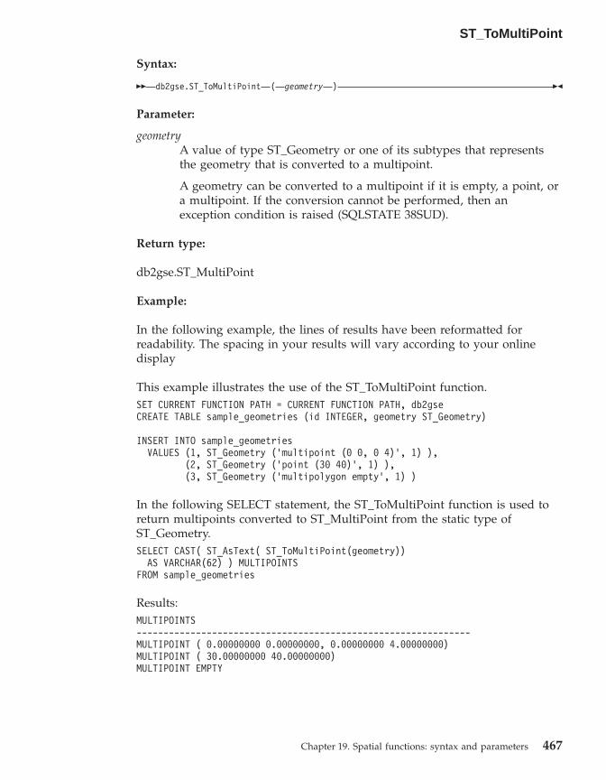
Syntax:
�� db2gse.ST_ToMultiPoint ( geometry ) ��
Parameter:
geometryA value of type ST_Geometry or one of its subtypes that representsthe geometry that is converted to a multipoint.
A geometry can be converted to a multipoint if it is empty, a point, ora multipoint. If the conversion cannot be performed, then anexception condition is raised (SQLSTATE 38SUD).
Return type:
db2gse.ST_MultiPoint
Example:
In the following example, the lines of results have been reformatted forreadability. The spacing in your results will vary according to your onlinedisplay
This example illustrates the use of the ST_ToMultiPoint function.SET CURRENT FUNCTION PATH = CURRENT FUNCTION PATH, db2gseCREATE TABLE sample_geometries (id INTEGER, geometry ST_Geometry)
INSERT INTO sample_geometriesVALUES (1, ST_Geometry (’multipoint (0 0, 0 4)’, 1) ),
(2, ST_Geometry (’point (30 40)’, 1) ),(3, ST_Geometry (’multipolygon empty’, 1) )
In the following SELECT statement, the ST_ToMultiPoint function is used toreturn multipoints converted to ST_MultiPoint from the static type ofST_Geometry.SELECT CAST( ST_AsText( ST_ToMultiPoint(geometry))
AS VARCHAR(62) ) MULTIPOINTSFROM sample_geometries
Results:MULTIPOINTS--------------------------------------------------------------MULTIPOINT ( 0.00000000 0.00000000, 0.00000000 4.00000000)MULTIPOINT ( 30.00000000 40.00000000)MULTIPOINT EMPTY
ST_ToMultiPoint
Chapter 19. Spatial functions: syntax and parameters 467
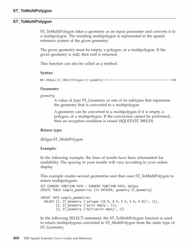
ST_ToMultiPolygon
ST_ToMultiPolygon takes a geometry as an input parameter and converts it toa multipolygon. The resulting multipolygon is represented in the spatialreference system of the given geometry.
The given geometry must be empty, a polygon, or a multipolygon. If thegiven geometry is null, then null is returned.
This function can also be called as a method.
Syntax:
�� db2gse.ST_ToMultiPolygon ( geometry ) ��
Parameter:
geometryA value of type ST_Geometry or one of its subtypes that representsthe geometry that is converted to a multipolygon.
A geometry can be converted to a multipolygon if it is empty, apolygon, or a multipolygon. If the conversion cannot be performed,then an exception condition is raised (SQLSTATE 38SUD).
Return type:
db2gse.ST_MultiPolygon
Example:
In the following example, the lines of results have been reformatted forreadability. The spacing in your results will vary according to your onlinedisplay
This example creates several geometries and then uses ST_ToMultiPolygon toreturn multipolygons.SET CURRENT FUNCTION PATH = CURRENT FUNCTION PATH, db2gseCREATE TABLE sample_geometries (id INTEGER, geometry ST_Geometry)
INSERT INTO sample_geometriesVALUES (1, ST_Geometry (’polygon ((0 0, 0 4, 5 4, 5 0, 0 0))’, 1)),
(2, ST_Geometry (’point empty’, 1)),(3, ST_Geometry (’multipoint empty’, 1))
In the following SELECT statement, the ST_ToMultiPolygon function is usedto return multipolygons converted to ST_MultiPolygon from the static type ofST_Geometry.
ST_ToMultiPolygon
468 DB2 Spatial Extender User’s Guide and Reference
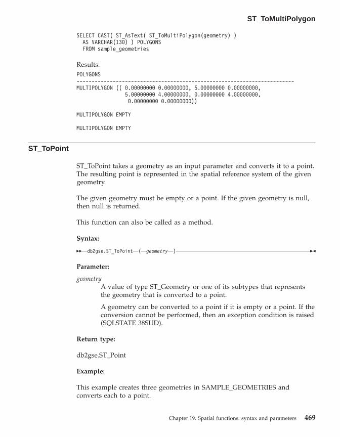
SELECT CAST( ST_AsText( ST_ToMultiPolygon(geometry) )AS VARCHAR(130) ) POLYGONSFROM sample_geometries
Results:POLYGONS------------------------------------------------------------------------MULTIPOLYGON (( 0.00000000 0.00000000, 5.00000000 0.00000000,
5.00000000 4.00000000, 0.00000000 4.00000000,0.00000000 0.00000000))
MULTIPOLYGON EMPTY
MULTIPOLYGON EMPTY
ST_ToPoint
ST_ToPoint takes a geometry as an input parameter and converts it to a point.The resulting point is represented in the spatial reference system of the givengeometry.
The given geometry must be empty or a point. If the given geometry is null,then null is returned.
This function can also be called as a method.
Syntax:
�� db2gse.ST_ToPoint ( geometry ) ��
Parameter:
geometryA value of type ST_Geometry or one of its subtypes that representsthe geometry that is converted to a point.
A geometry can be converted to a point if it is empty or a point. If theconversion cannot be performed, then an exception condition is raised(SQLSTATE 38SUD).
Return type:
db2gse.ST_Point
Example:
This example creates three geometries in SAMPLE_GEOMETRIES andconverts each to a point.
ST_ToMultiPolygon
Chapter 19. Spatial functions: syntax and parameters 469
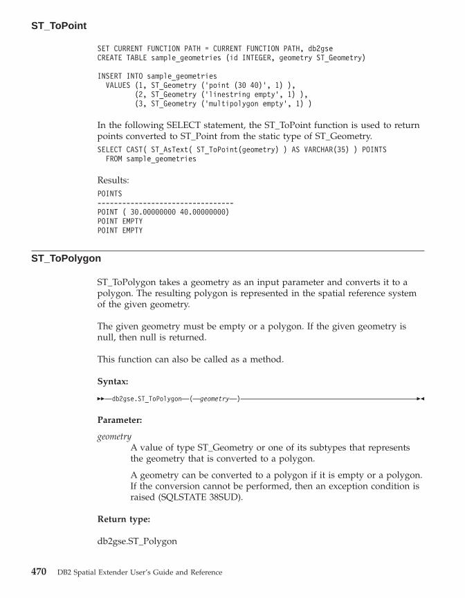
SET CURRENT FUNCTION PATH = CURRENT FUNCTION PATH, db2gseCREATE TABLE sample_geometries (id INTEGER, geometry ST_Geometry)
INSERT INTO sample_geometriesVALUES (1, ST_Geometry (’point (30 40)’, 1) ),
(2, ST_Geometry (’linestring empty’, 1) ),(3, ST_Geometry (’multipolygon empty’, 1) )
In the following SELECT statement, the ST_ToPoint function is used to returnpoints converted to ST_Point from the static type of ST_Geometry.SELECT CAST( ST_AsText( ST_ToPoint(geometry) ) AS VARCHAR(35) ) POINTS
FROM sample_geometries
Results:POINTS---------------------------------POINT ( 30.00000000 40.00000000)POINT EMPTYPOINT EMPTY
ST_ToPolygon
ST_ToPolygon takes a geometry as an input parameter and converts it to apolygon. The resulting polygon is represented in the spatial reference systemof the given geometry.
The given geometry must be empty or a polygon. If the given geometry isnull, then null is returned.
This function can also be called as a method.
Syntax:
�� db2gse.ST_ToPolygon ( geometry ) ��
Parameter:
geometryA value of type ST_Geometry or one of its subtypes that representsthe geometry that is converted to a polygon.
A geometry can be converted to a polygon if it is empty or a polygon.If the conversion cannot be performed, then an exception condition israised (SQLSTATE 38SUD).
Return type:
db2gse.ST_Polygon
ST_ToPoint
470 DB2 Spatial Extender User’s Guide and Reference

Example:
In the following example, the lines of results have been reformatted forreadability. The spacing in your results will vary according to your onlinedisplay
This example creates three geometries in SAMPLE_GEOMETRIES andconverts each to a polygon.SET CURRENT FUNCTION PATH = CURRENT FUNCTION PATH, db2gseCREATE TABLE sample_geometries (id INTEGER, geometry ST_Geometry)
INSERT INTO sample_geometriesVALUES (1, ST_Geometry (’polygon ((0 0, 0 4, 5 4, 5 0, 0 0))’, 1) ),
(2, ST_Geometry (’point empty’, 1) ),(3, ST_Geometry (’multipolygon empty’, 1) )
In the following SELECT statement, the ST_ToPolygon function is used toreturn polygons converted to ST_Polygon from the static type ofST_Geometry.SELECT CAST( ST_AsText( ST_ToPolygon(geometry) ) AS VARCHAR(130) ) POLYGONS
FROM sample_geometries
Results:POLYGONS-------------------------------------------------------------------------------POLYGON (( 0.00000000 0.00000000, 5.00000000 0.00000000,
5.00000000 4.00000000,0.00000000 4.00000000,0.00000000 0.00000000))
POLYGON EMPTY
POLYGON EMPTY
ST_Touches
ST_Touches takes two geometries as input parameters and returns 1 if thegiven geometries spatially touch. Otherwise, 0 (zero) is returned.
Two geometries touch if the interiors of both geometries do not intersect, butthe boundary of one of the geometries intersects with either the boundary orthe interior of the other geometry.
If the second geometry is not represented in the same spatial reference systemas the first geometry, it will be converted to the other spatial reference system.
If both of the given geometries are points or multipoints, or if any of thegiven geometries is null or empty, then null is returned.
ST_ToPolygon
Chapter 19. Spatial functions: syntax and parameters 471

Syntax:
�� db2gse.ST_Touches ( geometry1 , geometry2 ) ��
Parameters:
geometry1A value of type ST_Geometry or one of its subtypes that representsthe geometry that is to be tested to touch geometry2.
geometry2A value of type ST_Geometry or one of its subtypes that representsthe geometry that is to be tested to touch geometry1.
Return type:
INTEGER
Example:
Several geometries are added to the SAMPLE_GEOMS table. The ST_Touchesfunction is then used to determine which geometries touch each other.SET CURRENT FUNCTION PATH = CURRENT FUNCTION PATH, db2gseCREATE TABLE sample_geoms (id INTEGER, geometry ST_Geometry)
INSERT INTO sample_geomsVALUES (1, ST_Geometry(’polygon ( (20 30, 30 30, 30 40, 20 40, 20 30) )’ , 0) )
INSERT INTO sample_geomsVALUES (2, ST_Geometry(’polygon ( (30 30, 30 50, 50 50, 50 30, 30 30) )’ ,0) )
INSERT INTO sample_geomsVALUES (3, ST_Geometry(’polygon ( (40 40, 40 60, 60 60, 60 40, 40 40) )’ , 0) )
INSERT INTO sample_geomsVALUES (4, ST_Geometry(’linestring( 60 60, 70 70 )’ , 0) )
INSERT INTO sample_geomsVALUES (5, ST_Geometry(’linestring( 30 30, 60 60 )’ , 0) )
SELECT a.id, b.id, ST_Touches (a.geometry, b.geometry) TOUCHESFROM sample_geoms a, sample_geoms bWHERE b.id >= a.id
Results:ID ID TOUCHES----------- ----------- -----------
1 1 01 2 11 3 01 4 01 5 12 2 02 3 02 4 0
ST_Touches
472 DB2 Spatial Extender User’s Guide and Reference

2 5 13 3 03 4 13 5 14 4 04 5 15 5 0
Related reference:
v “Rules for using grid indexes to optimize spatial functions” on page 121
ST_Transform
ST_Transform takes a geometry and a spatial reference system identifier asinput parameters and transforms the geometry to be represented in the givenspatial reference system. Projections and conversions between differentcoordinate systems are performed and the coordinates of the geometries areadjusted accordingly.
The geometry can be converted to the specified spatial reference system onlyif the geometry’s current spatial reference system is based in the samegeographic coordinate system as the specified spatial spatial reference system.If either the geometry’s current spatial reference system or the specifiedspatial reference system is based on a projected coordinate system, a reverseprojection is performed to determine the geographic coordinate system thatunderlies the projected one.
If the given geometry is null, then null will be returned.
This function can also be called as a method.
Syntax:
�� db2gse.ST_Transform ( geometry , srs_id ) ��
Parameters:
geometryA value of type ST_Geometry or one of its subtypes that representsthe geometry that is transformed to the spatial reference systemidentified by srs_id.
srs_id A value of type INTEGER that identifies the spatial reference systemfor the resulting geometry.
If the transformation to the specified spatial reference system cannotbe performed because the current spatial reference system of geometry
ST_Touches
Chapter 19. Spatial functions: syntax and parameters 473
is not compatible with the spatial reference system identified by srs_id,then an exception condition is raised (SQLSTATE 38SUC).
If srs_id does not identify a spatial reference system listed in thecatalog view DB2GSE.ST_SPATIAL_REFERENCE_SYSTEMS, then anexception condition is raised (SQLSTATE 38SU1).
Return type:
db2gse.ST_Geometry
Examples:
The following examples illustrate the use of ST_Transform to convert ageometry from one spatial reference system to another.
First, the state plane spatial reference system with an ID of 3 is created usinga call to db2se.db2se create_srs SAMP_DB
-srsId 3 -srsName z3101a -xOffset 0 -yOffset 0 -xScale 1 -yScale 1- coordsysName NAD_1983_StatePlane_New_York_East_FIPS_3101_Feet
Then, points are added to:v The SAMPLE_POINTS_SP table in state plane coordinates using that spatial
reference system.v The SAMPLE_POINTS_LL table using coordinates specified in latitude and
longitude.SET CURRENT FUNCTION PATH = CURRENT FUNCTION PATH, db2gseCREATE TABLE sample_points_sp (id INTEGER, geometry ST_Point)CREATE TABLE sample_points_ll (id INTEGER, geometry ST_Point)
INSERT INTO sample_points_spVALUES (12457, ST_Point(’point ( 567176.0 1166411.0)’, 3) )
INSERT INTO sample_points_spVALUES (12477, ST_Point(’point ( 637948.0 1177640.0)’, 3) )
INSERT INTO sample_points_llVALUES (12457, ST_Point(’point ( -74.22371600 42.03498700)’, 1) )
INSERT INTO sample_points_llVALUES (12477, ST_Point(’point ( -73.96293200 42.06487900)’, 1) )
Then the ST_Transform function is used to convert the geometries.
Example 1:
ST_Transform
474 DB2 Spatial Extender User’s Guide and Reference

This example converts points that are in latitude and longitude coordinates tostate plane coordinates.SELECT id, CAST( ST_AsText( ST_Transform( geometry, 3) )
AS VARCHAR(100) ) STATE_PLANEFROM sample_points_ll
Results:ID STATE_PLANE----------- -----------------------------------------
12457 POINT ( 567176.00000000 1166411.00000000)12477 POINT ( 637948.00000000 1177640.00000000)
Example 2:
This example converts points that are in state plane coordinates to latitudeand longitude coordinates.SELECT id, CAST( ST_AsText( ST_Transform( geometry, 1) )
AS VARCHAR(100) ) LAT_LONGFROM sample_points_sp
Results:ID LAT_LONG----------- -----------------------------------------------------------------
12457 POINT ( -74.22371500 42.03498800)12477 POINT ( -73.96293100 42.06488000)
Related reference:
v “The DB2GSE.ST_SPATIAL_REFERENCE_SYSTEMS catalog view” on page238
ST_Union
ST_Union takes two geometries as input parameters and returns the geometrythat is the union of the given geometries. The resulting geometry isrepresented in the spatial reference system of the first geometry.
If the second geometry is not represented in the same spatial reference systemas the first geometry, it will be converted to the other spatial reference system.
If any of the two given geometries is null, then null is returned.
ST_Transform
Chapter 19. Spatial functions: syntax and parameters 475

The resulting geometry is represented in the most appropriate spatial type. Ifit can be represented as a point, linestring, or polygon, then one of those typesis used. Otherwise, the multipoint, multilinestring, or multipolygon type isused.
This function can also be called as a method.
Syntax:
�� db2gse.ST_Union ( geometry1 , geometry2 ) ��
Parameters:
geometry1A value of type ST_Geometry or one of its subtypes that is combinedwith geometry2.
geometry2A value of type ST_Geometry or one of its subtypes that is combinedwith geometry1.
Return type:
db2gse.ST_Geometry
Examples:
The following examples illustrate the use of the ST_Union function. Firstgeometries are created and inserted into the SAMPLE_GEOMS table and thenST_Union is used with those geometries.SET CURRENT FUNCTION PATH = CURRENT FUNCTION PATH, db2gseCREATE TABLE sample_geoms (id INTEGER, geometry, ST_Geometry)
INSERT INTO sample_geomsVALUES (1, ST_Geometry( ’polygon
((10 10, 10 20, 20 20, 20 10, 10 10) )’, 0))
INSERT INTO sample_geomsVALUES (2, ST_Geometry( ’polygon
((30 30, 30 50, 50 50, 50 30, 30 30) )’, 0))
INSERT INTO sample_geomsVALUES (3, ST_Geometry( ’polygon
((40 40, 40 60, 60 60, 60 40, 40 40) )’, 0))
INSERT INTO sample_geomsVALUES (4, ST_Geometry(’linestring (70 70, 80 80)’, 0))
INSERT INTO sample_geomsVALUES (5, ST_Geometry(’linestring (80 80, 100 70)’, 0))
ST_Union
476 DB2 Spatial Extender User’s Guide and Reference
In the following examples, the lines of results have been reformatted here forreadability. The spacing in your results will vary according to your onlinedisplay.
Example 1:
This example finds the union of two disjoint polygons.SELECT a.id, b.id, CAST ( ST_AsText( ST_Union( a.geometry, b.geometry) )
AS VARCHAR (350) ) UNIONFROM sample_geoms a, sample_geoms bWHERE a.id = 1 AND b.id = 2
Results:ID ID UNION----- ----- -------------------------------------------------------
1 2 MULTIPOLYGON ((( 10.00000000 10.00000000, 20.0000000010.00000000, 20.00000000 20.00000000, 10.0000000020.00000000, 10.00000000 10.00000000))
(( 30.00000000 30.00000000, 50.0000000030.00000000,50.00000000 50.00000000, 30.0000000050.00000000,30.00000000 30.00000000)))
Example 2:
This example finds the union of two intersecting polygons.SELECT a.id, b.id, CAST ( ST_AsText( ST_Union(a.geometry, b.geometry))
AS VARCHAR (250)) UNIONFROM sample_geoms a, sample_geoms bWHERE a.id = 2 AND b.id = 3
Results:ID ID UNION----- ----- ----------------------------------------------------
2 3 POLYGON (( 30.00000000 30.00000000, 50.0000000030.00000000,50.00000000 40.00000000, 60.0000000040.00000000,60.00000000 60.00000000, 40.0000000060.00000000 40.00000000 50.00000000, 30.0000000050.00000000, 30.00000000 30.00000000))
Example 3:
Find the union of two linestrings.SELECT a.id, b.id, CAST ( ST_AsText( ST_Union( a.geometry, b.geometry) )
AS VARCHAR (250) ) UNIONFROM sample_geoms a, sample_geoms bWHERE a.id = 4 AND b.id = 5
Results:ID ID UNION----- ----- ---------------------------------------------------------------
4 5 MULTILINESTRING (( 70.00000000 70.00000000, 80.00000000 80.00000000),( 80.00000000 80.00000000, 100.00000000 70.00000000))
ST_Union
Chapter 19. Spatial functions: syntax and parameters 477

ST_Within
ST_Within takes two geometries as input parameters and returns 1 if the firstgeometry is completely within the second geometry. Otherwise, 0 (zero) isreturned.
If the second geometry is not represented in the same spatial reference systemas the first geometry, it will be converted to the other spatial reference system.
If any of the given geometries is null or is empty, then null is returned.
ST_Within performs the same logical operation that ST_Contains performswith the parameters reversed.
Syntax:
�� db2gse.ST_Within ( geometry1 , geometry2 ) ��
Parameters:
geometry1A value of type ST_Geometry or one of its subtypes that is to betested to be fully within geometry2.
geometry2A value of type ST_Geometry or one of its subtypes that is to betested to be fully within geometry1.
Return type:
INTEGER
Examples:
These examples illustrate use of the ST_Within function. Geometries arecreated and inserted into three tables, SAMPLE_POINTS, SAMPLE_LINES,and SAMPLE_POLYGONS.SET CURRENT FUNCTION PATH = CURRENT FUNCTION PATH, db2gseCREATE TABLE sample_points (id INTEGER, geometry ST_Point)CREATE TABLE sample_lines (id INTEGER, line ST_LineString)CREATE TABLE sample_polygons (id INTEGER, geometry ST_Polygon)
INSERT INTO sample_points (id, geometry)VALUES (1, ST_Point (10, 20, 1) ),
(2, ST_Point (’point (41 41)’, 1) )
INSERT INTO sample_lines (id, line)VALUES (10, ST_LineString (’linestring (1 10, 3 12, 10 10)’, 1) ),
(20, ST_LineString (’linestring (50 10, 50 12, 45 10)’, 1) )
ST_Within
478 DB2 Spatial Extender User’s Guide and Reference

INSERT INTO sample_polygons (id, geometry)VALUES (100, ST_Polygon (’polygon (( 0 0, 0 40, 40 40, 40 0, 0 0))’, 1) )
Example 1:
This example finds points from the SAMPLE_POINTS table that are in thepolygons in the SAMPLE_POLYGONS table.SELECT a.id POINT_ID_WITHIN_POLYGONS
FROM sample_points a, sample_polygons bWHERE ST_Within( b.geometry, a.geometry) = 0
Results:POINT_ID_WITHIN_POLYGONS----------------------
2
Example 2:
This example finds linestrings from the SAMPLE_LINES table that are in thepolygons in the SAMPLE_POLYGONS table.SELECT a.id LINE_ID_WITHIN_POLYGONS
FROM sample_lines a, sample_polygons bWHERE ST_Within( b.geometry, a.geometry) = 0
Results:LINE_ID_WITHIN_POLYGONS----------------------
1
Related reference:
v “ST_Contains” on page 310
ST_WKBToSQL
ST_WKBToSQL takes a well-known binary representation of a geometry andreturns the corresponding geometry. The spatial reference system with theidentifier 0 (zero) is used for the resulting geometry.
If the given well-known binary representation is null, then null is returned.
ST_WKBToSQL(wkb) gives the same result as ST_Geometry(wkb,0). Using theST_Geometry function is recommended over using ST_WKBToSQL because ofits flexibility: ST_Geometry takes additional forms of input as well as thewell-known binary representation.
ST_Within
Chapter 19. Spatial functions: syntax and parameters 479

Syntax:
�� db2gse.ST_WKBToSQL ( wkb ) ��
Parameter:
wkb A value of type BLOB(2G) that contains the well-known binaryrepresentation of the resulting geometry.
Return type:
db2gse.ST_Geometry
Example:
In the following example, the lines of results have been reformatted forreadability. The spacing in your results will vary according to your onlinedisplay.
This example illustrates use of the ST_WKBToSQL function. First, geometriesare stored in the SAMPLE_GEOMETRIES table in its GEOMETRY column.Then, their well-known binary representations are stored in the WKB columnusing the ST_AsBinary function in the UPDATE statement. Finally, theST_WKBToSQL function is used to return the coordinates of the geometries inthe WKB column.SET CURRENT FUNCTION PATH = CURRENT FUNCTION PATH, db2gseCREATE TABLE sample_geometries
(id INTEGER, geometry ST_Geometry, wkb BLOB(32K) )
INSERT INTO sample_geometries (id, geometry)VALUES (10, ST_Point ( ’point (44 14)’, 0 ) ),
(11, ST_Point ( ’point (24 13)’, 0 ) ),(12, ST_Polygon (’polygon ((50 20, 50 40, 70 30, 50 20))’, 0 ) )
UPDATE sample_geometries AS temp_correlatedSET wkb = ST_AsBinary(geometry)WHERE id = temp_correlated.id
Use this SELECT statement to see the geometries in the WKB column.SELECT id, CAST( ST_AsText( ST_WKBToSQL(wkb) ) AS VARCHAR(120) ) GEOMETRIES
FROM sample_geometries
Results:ID GEOMETRIES----------- -------------------------------------------------------------
10 POINT ( 44.00000000 14.00000000)11 POINT ( 24.00000000 13.00000000)12 POLYGON (( 50.00000000 20.00000000, 70.00000000 30.00000000,
50.00000000 40.00000000, 50.00000000 20.00000000))
ST_WKBToSQL
480 DB2 Spatial Extender User’s Guide and Reference

Related concepts:
v “Spatial data” on page 4
Related reference:
v “ST_Geometry” on page 351v “ST_WKTToSQL” on page 481
ST_WKTToSQL
ST_WKTToSQL takes a well-known text representation of a geometry andreturns the corresponding geometry. The spatial reference system with theidentifier 0 (zero) is used for the resulting geometry.
If the given well-known text representation is null, then null is returned.
ST_WKTToSQL(wkt) gives the same result as ST_Geometry(wkt,0). Using theST_Geometry function is recommended over using ST_WKTToSQL because ofits flexibility: ST_Geometry takes additional forms of input as well as thewell-known text representation.
Syntax:
�� db2gse.ST_WKTToSQL ( wkt ) ��
Parameter:
wkt A value of type CLOB(2G) that contains the well-known textrepresentation of the resulting geometry.
Return type:
db2gse.ST_Geometry
Example:
In the following example, the lines of results have been reformatted forreadability. The spacing in your results will vary according to your onlinedisplay.
This example illustrates how ST_WKTToSQL can create and insert geometriesusing their well-known text representations.SET CURRENT FUNCTION PATH = CURRENT FUNCTION PATH, db2gseCREATE TABLE sample_geometries (id INTEGER, geometry ST_Geometry)
INSERT INTO sample_geometries
ST_WKBToSQL
Chapter 19. Spatial functions: syntax and parameters 481

VALUES (10, ST_WKTToSQL( ’point (44 14)’ ) ),(11, ST_WKTTSQL ( ’point (24 13)’ ) ),(12, ST_WKTToSQL (’polygon ((50 20, 50 40, 70 30, 50 20))’ ) )
This SELECT statement returns the geometries that have been inserted.SELECT id, CAST( ST_AsText(geometry) AS VARCHAR(120) ) GEOMETRIES
FROM sample_geometries
Results:ID GEOMETRIES----------- -------------------------------------------------------------
10 POINT ( 44.00000000 14.00000000)11 POINT ( 24.00000000 13.00000000)12 POLYGON (( 50.00000000 20.00000000, 70.00000000 30.00000000,
50.00000000 40.00000000, 50.00000000 20.00000000))
Related concepts:
v “Spatial data” on page 4
Related reference:
v “ST_Geometry” on page 351v “ST_WKBToSQL” on page 479
ST_X
ST_X takes either:v A point as an input parameter and returns its X coordinatev A point and an X coordinate and returns the point itself with its X
coordinate set to the given value
If the given point is null or is empty, then null is returned.
This function can also be called as a method.
Syntax:
�� db2gse.ST_X ( point ), x_coordinate
��
Parameters:
point A value of type ST_Point for which the X coordinate is returned ormodified.
x_coordinateA value of type DOUBLE that represents the new X coordinate forpoint.
ST_WKTToSQL
482 DB2 Spatial Extender User’s Guide and Reference
Return types:
v DOUBLE, if x_coordinate is not specifiedv db2gse.ST_Point, if x_coordinate is specified
Examples:
These examples illustrate use of the ST_X function. Geometries are createdand inserted into the SAMPLE_POINTS table.SET CURRENT FUNCTION PATH = CURRENT FUNCTION PATH, db2gseCREATE TABLE sample_points (id INTEGER, geometry ST_Point)
INSERT INTO sample_points (id, geometry)VALUES (1, ST_Point (2, 3, 32, 5, 1) ),
(2, ST_Point (4, 5, 20, 4, 1) ),(3, ST_Point (3, 8, 23, 7, 1) )
Example 1:
This example finds the X coordinates of the points in the table.SELECT id, ST_X (geometry) X_COORD
FROM sample_points
Results:ID X_COORD---------- ----------------------
1 +2.00000000000000E+0002 +4.00000000000000E+0003 +3.00000000000000E+000
Example 2:
This example returns a point with its X coordinate set to 40.SELECT id, CAST( ST_AsText( ST_X (geometry, 40)) AS VARCHAR(60) )
X_40FROM sample_pointsWHERE id=3
Results:ID X_40------ ----------------------------------------------------------
3 POINT ZM ( 40.00000000 8.00000000 23.00000000 7.00000000)
Related reference:
v “ST_M” on page 384v “ST_Y” on page 484v “ST_Z” on page 485
ST_X
Chapter 19. Spatial functions: syntax and parameters 483

ST_Y
ST_Y takes either:v A point as an input parameter and returns its Y coordinatev A point and a Y coordinate and returns the point itself with its Y coordinate
set to the given value
If the given point is null or is empty, then null is returned.
This function can also be called as a method.
Syntax:
�� db2gse.ST_Y ( point ), y_coordinate
��
Parameters:
point A value of type ST_Point for which the Y coordinate is returned ormodified.
y_coordinateA value of type DOUBLE that represents the new Y coordinate forpoint.
Return types:
v DOUBLE, if y_coordinate is not specifiedv db2gse.ST_Point, if y_coordinate is specified
Examples:
These examples illustrate use of the ST_Y function. Geometries are createdand inserted into the SAMPLE_POINTS table.SET CURRENT FUNCTION PATH = CURRENT FUNCTION PATH, db2gseCREATE TABLE sample_points (id INTEGER, geometry ST_Point)
INSERT INTO sample_points (id, geometry)VALUES (1, ST_Point (2, 3, 32, 5, 1) ),
(2, ST_Point (4, 5, 20, 4, 1) ),(3, ST_Point (3, 8, 23, 7, 1) )
Example 1:
This example finds the Y coordinates of the points in the table.SELECT id, ST_Y (geometry) Y_COORD
FROM sample_points
ST_Y
484 DB2 Spatial Extender User’s Guide and Reference

Results:ID Y_COORD---------- ----------------------
1 +3.00000000000000E+0002 +5.00000000000000E+0003 +8.00000000000000E+000
Example 2:
This example returns a point with its Y coordinate set to 40.SELECT id, CAST( ST_AsText( ST_Y (geometry, 40)) AS VARCHAR(60) )
Y_40FROM sample_pointsWHERE id=3
Results:ID Y_40-------- -------------------------------------------------------
3 POINT ZM ( 3.00000000 40.00000000 23.00000000 7.00000000)
Related reference:
v “ST_M” on page 384v “ST_X” on page 482v “ST_Z” on page 485
ST_Z
ST_Z takes either:v A point as an input parameter and returns its Z coordinatev A point and a Z coordinate and returns the point itself with its Z coordinate
set to the given value, even if the specified point has no existing Zcoordinate.
If the specified Z coordinate is null, then the Z coordinate is removed fromthe point.
If the specified point is null or empty, then null is returned.
This function can also be called as a method.
Syntax:
�� db2gse.ST_Z ( point ), z_coordinate
��
Parameters:
ST_Y
Chapter 19. Spatial functions: syntax and parameters 485

point A value of type ST_Point for which the Z coordinate is returned ormodified.
z_coordinateA value of type DOUBLE that represents the new Z coordinate forpoint.
If z_coordinate is null, then the Z coordinate is removed from point.
Return types:
v DOUBLE, if z_coordinate is not specifiedv db2gse.ST_Point, if z_coordinate is specified
Examples:
These examples illustrate use of the ST_Z function. Geometries are createdand inserted into the SAMPLE_POINTS table.SET CURRENT FUNCTION PATH = CURRENT FUNCTION PATH, db2gseCREATE TABLE sample_points (id INTEGER, geometry ST_Point)
INSERT INTO sample_points (id, geometry)VALUES (1, ST_Point (2, 3, 32, 5, 1) ),
(2, ST_Point (4, 5, 20, 4, 1) ),(3, ST_Point (3, 8, 23, 7, 1) )
Example 1:
This example finds the Z coordinates of the points in the table.SELECT id, ST_Z (geometry) Z_COORD
FROM sample_points
Results:ID Z_COORD---------- ----------------------
1 +3.20000000000000E+0012 +2.00000000000000E+0013 +2.30000000000000E+001
Example 2:
This example returns a point with its Z coordinate set to 40.SELECT id, CAST( ST_AsText( ST_Z (geometry, 40)) AS VARCHAR(60) )
Z_40FROM sample_pointsWHERE id=3
Results:
ST_Z
486 DB2 Spatial Extender User’s Guide and Reference

ID Z_40------ -------------------------------------------------------
3 POINT ZM ( 3.00000000 8.00000000 40.00000000 7.00000000)
Related reference:
v “ST_M” on page 384v “ST_X” on page 482v “ST_Y” on page 484
Union aggregate
A union aggregate is the combination of the ST_BuildUnionAggr andST_GetAggrResult functions. This combination aggregates a column ofgeometries in a table to single geometry by constructing the union.
If all of the geometries to be combined in the union are null , then null isreturned. If each of the geometries to be combined in the union are either nullor are empty, then an empty geometry of type ST_Point is returned.
The ST_BuildUnionAggr function can also be called as a method.
Syntax:
�� db2gse.ST_GetAggrResult ( �
� MAX ( db2sge.ST_BuildUnionAggr ( geometries ) ) ) ��
Parameters:
geometriesA column in a table that has a type of ST_Geometry or one of itssubtypes and represents all the geometries that are to be combinedinto a union.
Return type:
db2gse.ST_Geometry
Restrictions:
You cannot construct the union aggregate of a spatial column in a table in anyof the following situations:v In massively parallel processing (MPP) environmentsv If a GROUP BY clause is used in the selectv If you use a function other than the DB2 aggregate function MAX
ST_Z
Chapter 19. Spatial functions: syntax and parameters 487

Example:
In the following example, the lines of results have been reformatted forreadability. The spacing in your results will vary according to your onlinedisplay.
This example illustrates how a union aggregate can be used to combine a setof points into multipoints. Several points are added to the SAMPLE_POINTStable. The ST_GetAggrResult and ST_BuildUnionAggr functions are used toconstruct the union of the points.SET CURRENT FUNCTION PATH = CURRENT FUNCTION PATH, db2gseCREATE TABLE sample_points (id INTEGER, geometry ST_Point)
INSERT INTO sample_pointsVALUES (1, ST_Point (2, 3, 1) )
INSERT INTO sample_pointsVALUES (2, ST_Point (4, 5, 1) )
INSERT INTO sample_pointsVALUES (3, ST_Point (13, 15, 1) )
INSERT INTO sample_pointsVALUES (4, ST_Point (12, 5, 1) )
INSERT INTO sample_pointsVALUES (5, ST_Point (23, 2, 1) )
INSERT INTO sample_pointsVALUES (6, ST_Point (11, 4, 1) )
SELECT CAST (ST_AsText(ST_GetAggrResult( MAX( ST_BuildUnionAggregate (geometry) ) ))
AS VARCHAR(160)) POINT_AGGREGATEFROM sample_points
Results:POINT_AGGREGATE----------------------------------------------------------MULTIPOINT ( 2.00000000 3.00000000, 4.00000000 5.00000000,
11.00000000 4.00000000, 12.00000000 5.00000000,13.00000000 15.00000000, 23.00000000 2.00000000)
Union aggregate
488 DB2 Spatial Extender User’s Guide and Reference

Chapter 20. Transform groups
Transform groups
Spatial Extender provides four transform groups that can be used with thefollowing data exchange formats while geometries are transferred between theDB2 server and a client application.v Well-known text representation (WKT)v Well-known binary representation (WKB)v ESRI shape representationv Geography Markup Language (GML)
When retrieving data from a table that contains a spatial column, the datafrom the spatial column will be transformed to either a CLOB(2G) or aBLOB(2G), depending on whether a binary or textual representation waschosen. Also, when transferring spatial data in one of the listed data exchangeformats to the database, the transform groups can be used.
To select which transform group is to be used when the data is transferred,the SET CURRENT DEFAULT TRANSFORM GROUP statement must be usedto modify the DB2 special register CURRENT DEFAULT TRANSFORMGROUP. DB2 will use the value of the special register to determine whichtransform functions must be called to perform the necessary conversions.
Transform groups can simplify application programming. Instead of explicitlyusing conversion functions in the SQL statements, you can specify a transformgroup, which lets DB2 take care of that task.
ST_WellKnownTextThe ST_WellKnownText transform group can be used to transmit data to andfrom DB2 using the well-known text (WKT) representation.
When binding out a value from the database server to the client, the samefunctionality provided by ST_AsText() is used to convert a geometry to WKT.When transferring the well-known text representation of a geometry to thedatabase server, the ST_Geometry(CLOB) function is implicitly used toperform the conversions to an ST_Geometry value. Using the transform groupfor binding in values to DB2 causes the geometries to be represented in thespatial reference system with the numeric identifier 0 (zero).
Example:
© Copyright IBM Corp. 1998 - 2002 489

In the following examples, the lines of results have been reformatted forreadability. The spacing in your results will vary according to your onlinedisplay.
Example 1:
The following SQL script shows how the ST_WellKnownText transform groupcan be used to retrieve a geometry in its well-known text representationwithout using the explicit ST_AsText function.CREATE TABLE transforms_sample (
id INTEGER,geom db2gse.ST_Geometry)
INSERTINTO transforms_sampleVALUES (1, db2gse.ST_LineString(’linestring
(100 100, 200 100)’, 0))
SET CURRENT DEFAULT TRANSFORM GROUP = ST_WellKnownText
SELECT id, geomFROM transforms_sampleWHERE id = 1
Results:ID GEOM--- -------------------------------------------------------------------
1 LINESTRING ( 100.00000000 100.00000000, 200.00000000 100.00000000)
Example 2:
The following C code illustrates how to use the ST_WellKnownText transformgroup for inserting geometries using explicit ST_Geometry function for thehost-variable wkt_buffer, which is of type CLOB and contains the well-knowntext representation of the point (10 10) that is to be inserted.EXEC SQL BEGIN DECLARE SECTION;
sqlint32 id = 0;SQL TYPE IS db2gse.ST_Geometry AS CLOB(1000) wkt_buffer;
EXEC SQL END DECLARE SECTION;
// set the transform group for all subsequent SQL statementsEXEC SQL
SET CURRENT DEFAULT TRANSFORM GROUP = ST_WellKnownText;
id = 100;strcpy(wkt_buffer.data, "point ( 10 10 )");wkt_buffer.length = strlen(wkt_buffer.data);
// insert point using WKT into column of type ST_Geometry
ST_WellKnownText
490 DB2 Spatial Extender User’s Guide and Reference

EXEC SQLINSERTINTO transforms_sample(id, geom)VALUES (:id, :wkt_buffer);
ST_WellKnownBinaryThe ST_WellKnownBinary transform group can be used to transmit data toand from DB2 using the well-known binary (WKB) representation.
When binding out a value from the database server to the client, the samefunctionality provided by ST_AsBinary() is used to convert a geometry toWKB. When transferring the well-known binary representation of a geometryto the database server, the ST_Geometry(BLOB) function is used implicitly toperform the conversions to an ST_Geometry value. Using the transform groupfor binding in values to DB2 causes the geometries to be represented in thespatial reference system with the numeric identifier 0 (zero).
Example:
In the following examples, the lines of results have been reformatted forreadability. The spacing in your results will vary according to your onlinedisplay.
Example 1:
The following SQL script shows how the ST_WellKnownBinary transformgroup can be used to retrieve a geometry in its well-known binaryrepresentation without using the explicit ST_AsBinary function.CREATE TABLE transforms_sample (
id INTEGER,geom db2gse.ST_Geometry)
INSERTINTO transforms_sampleVALUES ( 1, db2gse.ST_Polygon(’polygon ((10 10, 20 10, 20 20,
10 20, 10 10))’, 0))
SET CURRENT DEFAULT TRANSFORM GROUP = ST_WellKnownBinary
SELECT id, geomFROM transforms_sampleWHERE id = 1
Results:ID GEOM---- ----------------------------------------------
1 x’01030000000100000005000000000000000000244000
ST_WellKnownText
Chapter 20. Transform groups 491

0000000000244000000000000024400000000000003440000000000000344000000000000034400000000000003440000000000000244000000000000024400000000000002440’
Example 2:
The following C code illustrates how to use the ST_WellKnownBinarytransform group for inserting geometries using the explicit ST_Geometryfunction for the host-variable wkb_buffer, which is of type BLOB and containsthe well-known binary representation of a geometry that is to be inserted.EXEC SQL BEGIN DECLARE SECTION;
sqlint32 id = 0;SQL TYPE IS db2gse.ST_Geometry AS BLOB(1000) wkb_buffer;
EXEC SQL END DECLARE SECTION;
// set the transform group for all subsequent SQL statementsEXEC SQL
SET CURRENT DEFAULT TRANSFORM GROUP = ST_WellKnownBinary;
// initialize host variables...// insert geometry using WKB into column of type ST_Geometry
EXEC SQLINSERTINTO transforms_sample(id, geom)VALUES ( :id, :wkb_buffer );
ST_ShapeThe ST_Shape transform group can be used to transmit data to and from DB2using the shape representation.
When binding out a value from the database server to the client, the samefunctionality provided by ST_AsShape() is used to convert a geometry to itsshape representation. When transferring the shape representation of ageometry to the database server, the ST_Geometry(BLOB) function is usedimplicitly to perform the conversions to an ST_Geometry value. Using thetransform group for binding in values to DB2 causing the geometries to berepresented in the spatial reference system with the numeric identifier 0(zero).
Examples:
In the following examples, the lines of results have been reformatted forreadability. The spacing in your results will vary according to your onlinedisplay.
Example 1:
ST_WellKnownBinary
492 DB2 Spatial Extender User’s Guide and Reference
The following SQL script shows how the ST_Shape transform group can beused to retrieve a geometry in its shape representation without using theexplicit ST_AsShape function.CREATE TABLE transforms_sample(
id INTEGER,geom db2gse.ST_Geometry)
INSERTINTO transforms_sampleVALUES ( 1, db2gse.ST_Point(20.0, 30.0, 0) )
SET CURRENT DEFAULT TRANSFORM GROUP = ST_Shape
SELECT id, geomFROM transforms_sampleWHERE id = 1
Results:ID GEOM---- ---------------------------------------------
1 x’0100000000000000000034400000000000003E40’
Example 2:
The following C code illustrates how to use the ST_Shape transform group forinserting geometries using the explicit ST_Geometry function for thehost-variable shape_buffer, which is of type BLOB and contains the shaperepresentation of a geometry that is to be inserted.EXEC SQL BEGIN DECLARE SECTION;
sqlint32 id = 0;SQL TYPE IS db2gse.ST_Geometry AS BLOB(1000) shape_buffer;
EXEC SQL END DECLARE SECTION;
// set the transform group for all subsequent SQL statementsEXEC SQL
SET CURRENT DEFAULT TRANSFORM GROUP = ST_Shape;
// initialize host variables...
SET CURRENT DEFAULT TRANSFORM GROUP = ST_Shape;
// insert geometry using shape representation into column of type ST_GeometryEXEC SQL
INSERTINTO transforms_sample(id, geom)VALUES ( :id, :shape_buffer );
ST_GMLThe ST_GML transform group can be used to transmit data to and from DB2using the geography markup language (GML).
ST_Shape
Chapter 20. Transform groups 493
When binding out a value from the database server to the client, the samefunctionality provided by ST_AsGML() is used to convert a geometry to itsGML representation. When transferring the GML representation of a geometryto the database server, the ST_Geometry(CLOB) function is used implicitly toperform the conversions to an ST_Geometry value. Using the transform groupfor binding in values to DB2 causing the geometries to be represented in thespatial reference system with the numeric identifier 0 (zero).
Example:
In the following examples, the lines of results have been reformatted forreadability. The spacing in your results will vary according to your onlinedisplay.
Example 1:
The following SQL script shows how the ST_GML transform group can beused to retrieve a geometry in its GML representation without using theexplicit ST_AsGML function.CREATE TABLE transforms_sample (
id INTEGER,geom db2gse.ST_Geometry)
INSERTINTO transforms_sampleVALUES ( 1, db2gse.ST_Geometry(’multipoint z (10 10
3, 20 20 4, 15 20 30)’, 0) )SET CURRENT DEFAULT TRANSFORM GROUP = ST_GML
SELECT id, geomFROM transforms_sampleWHERE id = 1
Results:ID GEOM----- -------------------------------------------------------------
1 <gml:MultiPoint srsName=UNSPECIFIED><gml:PointMember><gml:Point><gml:coord><gml:X>10</gml:X><gml:Y>10</gml:Y><gml:Z>3</gml:Z></gml:coord></gml:Point></gml:PointMember><gml:PointMember><gml:Point><gml:coord><gml:X>20</gml:X><gml:Y>20</gml:Y><gml:Z>4</gml:Z></gml:coord></gml:Point></gml:PointMember><gml:PointMember><gml:Point><gml:coord><gml:X>15</gml:X><gml:Y>20</gml:Y><gml:Z>30</gml:Z></gml:coord></gml:Point></gml:PointMember></gml:MultiPoint>
Example 2:
ST_GML
494 DB2 Spatial Extender User’s Guide and Reference

The following C code illustrates how to use the ST_GML transform group forinserting geometries without the need to use the explicit ST_Geometryfunction for the host-variable gml_buffer, which is of type CLOB and containsthe GML representation of the point (20 ,20) that is to be inserted.EXEC SQL BEGIN DECLARE SECTION;
sqlint32 id = 0;SQL TYPE IS db2gse.ST_Geometry AS CLOB(1000) gml_buffer;
EXEC SQL END DECLARE SECTION;
// set the transform group for all subsequent SQL statementsEXEC SQL
SET CURRENT DEFAULT TRANSFORM GROUP = ST_GML;id = 100;strcpy(gml_buffer.data, "<gml:point><gml:coord>"
"<gml:X>20</gml:X> <gml:Y>20</gml:Y></gml:coord></gml:point>");
//initialize host variableswkt_buffer.length = strlen(gml_buffer.data);
// insert point using WKT into column of type ST_GeometryEXEC SQL
INSERTINTO transforms_sample(id, geom)VALUES ( :id, :gml_buffer );
ST_GML
Chapter 20. Transform groups 495

ST_GML
496 DB2 Spatial Extender User’s Guide and Reference

Chapter 21. Supported data formats
This chapter describes the industry standard spatial data formats that can beused with DB2 Spatial Extender. See “Spatial functions that convertgeometries to and from data exchange formats” on page 243 for informationon functions which accept and produce these formats. See “About importingand exporting spatial data” on page 89 for information on importing andexporting files containing these formats. The following four spatial dataformats are described:v Well-known text (WKT) representationv Well-known binary (WKB) representationv Shape representationv Geography Markup Language (GML) representation
Well-known text (WKT) representation
The OpenGIS Consortium ″Simple Features for SQL″ specification defines thewell-known text representation to exchange geometry data in ASCII format.This representation is also referenced by the ISO ″SQL/MM Part: 3 Spatial″standard. See ″Spatial functions that convert geometries to and from dataexchange formats″ for information on functions which accept and produceWKT data.
The well-known text representation of a geometry is defined as follows:
�� POINTLINESTRINGPOLYGONMULTIPOINTMULTILINESTRINGMULTIPOLYGON
point-tagged-textlinestring-tagged textpolygon-tagged-textmultipoint-tagged-textmultilinestring-tagged-textmultipolygon-tagged-text
��
point-tagged-text:
EMPTY( point-coordinates )
Z EMPTY( point-z-coordinates )
M EMPTY( point-m-coordinates )
ZM EMPTY( point-zm-coordinates )
© Copyright IBM Corp. 1998 - 2002 497

linestring-tagged-text:
EMPTY( linestring-points )
Z EMPTY( linestring-z-points )
M EMPTY( linestring-m-points )
ZM EMPTY( linestring-zm-points )
polygon-tagged-text:
EMPTY( polygon-rings )
Z EMPTY( polygon-z-rings )
M EMPTY( polygon-m-rings )
ZM EMPTY( polygon-zm-rings )
multipoint-tagged-text:
EMPTY( multipoint-parts )
Z EMPTY( multipoint-z-parts )
M EMPTY( multipoint-m-parts )
ZM EMPTY( multipoint-zm-parts )
multilinestring-tagged-text:
EMPTY( multilinestring-parts )
Z EMPTY( multilinestring-z-parts )
M EMPTY( multilinestring-m-parts )
ZM EMPTY( multilinestring-zm-parts )
multipolygon-tagged-text:
Well-known text (WKT) representation
498 DB2 Spatial Extender User’s Guide and Reference
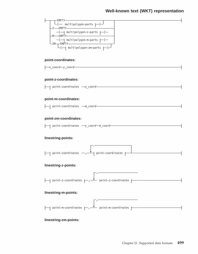
EMPTY( multipolygon-parts )
Z EMPTY( multipolygon-z-parts )
M EMPTY( multipolygon-m-parts )
ZM EMPTY( multipolygon-zm-parts )
point-coordinates:
x_coord y_coord
point-z-coordinates:
point-coordinates y_coord
point-m-coordinates:
point-coordinates m_coord
point-zm-coordinates:
point-coordinates y_coord m_coord
linestring-points:
point-coordinates , P
,
point-coordinates
linestring-z-points:
point-z-coordinates , P
,
point-z-coordinates
linestring-m-points:
point-m-coordinates , P
,
point-m-coordinates
linestring-zm-points:
Well-known text (WKT) representation
Chapter 21. Supported data formats 499
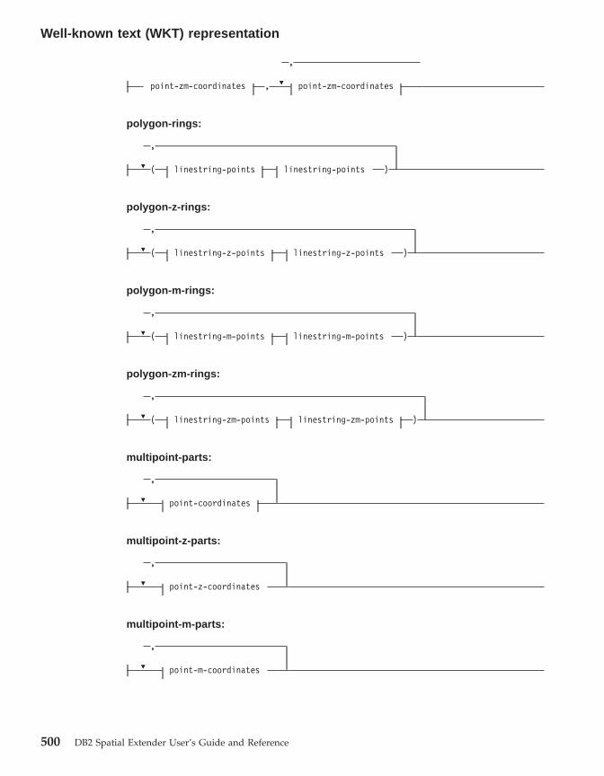
point-zm-coordinates , P
,
point-zm-coordinates
polygon-rings:
P
,
( linestring-points linestring-points )
polygon-z-rings:
P
,
( linestring-z-points linestring-z-points )
polygon-m-rings:
P
,
( linestring-m-points linestring-m-points )
polygon-zm-rings:
P
,
( linestring-zm-points linestring-zm-points )
multipoint-parts:
P
,
point-coordinates
multipoint-z-parts:
P
,
point-z-coordinates
multipoint-m-parts:
P
,
point-m-coordinates
Well-known text (WKT) representation
500 DB2 Spatial Extender User’s Guide and Reference

multipoint-zm-parts:
P
,
point-zm-coordinates
multilinestring-parts:
P
,
( linestring-points )
multilinestring-z-parts:
P
,
( linestring-z-points )
multilinestring-m-parts:
P
,
( linestring-m-points )
multilinestring-zm-parts:
P
,
( linestring-zm-points )
multipolygon-parts:
P
,
( polygon-rings )
multipolygon-z-parts:
P
,
( polygon-z-rings )
multipolygon-m-parts:
P
,
( polygon-m-rings )
Well-known text (WKT) representation
Chapter 21. Supported data formats 501
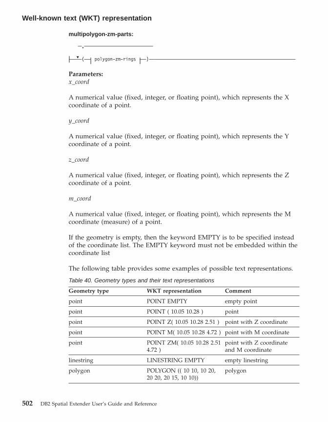
multipolygon-zm-parts:
P
,
( polygon-zm-rings )
Parameters:x_coord
A numerical value (fixed, integer, or floating point), which represents the Xcoordinate of a point.
y_coord
A numerical value (fixed, integer, or floating point), which represents the Ycoordinate of a point.
z_coord
A numerical value (fixed, integer, or floating point), which represents the Zcoordinate of a point.
m_coord
A numerical value (fixed, integer, or floating point), which represents the Mcoordinate (measure) of a point.
If the geometry is empty, then the keyword EMPTY is to be specified insteadof the coordinate list. The EMPTY keyword must not be embedded within thecoordinate list
The following table provides some examples of possible text representations.
Table 40. Geometry types and their text representations
Geometry type WKT representation Comment
point POINT EMPTY empty point
point POINT ( 10.05 10.28 ) point
point POINT Z( 10.05 10.28 2.51 ) point with Z coordinate
point POINT M( 10.05 10.28 4.72 ) point with M coordinate
point POINT ZM( 10.05 10.28 2.514.72 )
point with Z coordinateand M coordinate
linestring LINESTRING EMPTY empty linestring
polygon POLYGON (( 10 10, 10 20,20 20, 20 15, 10 10))
polygon
Well-known text (WKT) representation
502 DB2 Spatial Extender User’s Guide and Reference

Table 40. Geometry types and their text representations (continued)
Geometry type WKT representation Comment
multipoint MULTIPOINT Z(10 10 2, 2020 3)
multipoint with Zcoordinates
multilinestring MULTILINESTRING M((310 30 1, 40 30 20, 50 20 10)( 10 10 0, 20 20 1))
multilinestring with Mcoordinates
multipolygon MULTIPOLYGON ZM((( 11 1 1, 1 2 3 4, 2 2 5 6, 2 1 78, 1 1 1 1 )))
multipolygon with Zcoordinates and Mcoordinates
Related reference:
v “Spatial functions that convert geometries to and from data exchangeformats” on page 243
Well-known binary (WKB) representation
This section describes the well-known binary representation for geometries.
The OpenGIS Consortium ″Simple Features for SQL″ specification defines thewell-known binary representation. This representation is also defined by theInternational Organization for Standardization (ISO) ″SQL/MM Part: 3Spatial″ standard. See the related reference section at the end of this topic forinformation on functions that accept and produce the WKB.
The basic building block for well-known binary representations is the bytestream for a point, which consists of two double values. The byte streams forother geometries are built using the byte streams for geometries that arealready defined.
The following example illustrates the basic building block for well-knownbinary representations.// Basic Type definitions// byte : 1 byte// uint32 : 32 bit unsigned integer (4 bytes)// double : double precision number (8 bytes)
// Building Blocks : Point, LinearRing
Point {double x;double y;
};LinearRing {
uint32 numPoints;
Well-known text (WKT) representation
Chapter 21. Supported data formats 503

Point points[numPoints];};enum wkbGeometryType {
wkbPoint = 1,wkbLineString = 2,wkbPolygon = 3,wkbMultiPoint = 4,wkbMultiLineString = 5,wkbMultiPolygon = 6
};enum wkbByteOrder {
wkbXDR = 0, // Big EndianwkbNDR = 1 // Little Endian
};WKBPoint {
byte byteOrder;uint32 wkbType; // 1=wkbPointPoint point;
};WKBLineString {
byte byteOrder;uint32 wkbType; // 2=wkbLineStringuint32 numPoints;Point points[numPoints];
};
WKBPolygon {byte byteOrder;uint32 wkbType; // 3=wkbPolygonuint32 numRings;LinearRing rings[numRings];
};WKBMultiPoint {
byte byteOrder;uint32 wkbType; // 4=wkbMultipointuint32 num_wkbPoints;WKBPoint WKBPoints[num_wkbPoints];
};WKBMultiLineString {
byte byteOrder;uint32 wkbType; // 5=wkbMultiLineStringuint32 num_wkbLineStrings;WKBLineString WKBLineStrings[num_wkbLineStrings];
};
wkbMultiPolygon {byte byteOrder;uint32 wkbType; // 6=wkbMultiPolygonuint32 num_wkbPolygons;WKBPolygon wkbPolygons[num_wkbPolygons];
};
WKBGeometry {union {
WKBPoint point;
Well-known binary (WKB) representation
504 DB2 Spatial Extender User’s Guide and Reference

WKBLineString linestring;WKBPolygon polygon;WKBMultiPoint mpoint;WKBMultiLineString mlinestring;WKBMultiPolygon mpolygon;
}};
The following figure shows an example of a geometry in well-known binaryrepresentation using NDR coding.
Related reference:
v “Spatial functions that convert geometries to and from data exchangeformats” on page 243
Shape representation
Shape representation is a widely used industry standard defined by ESRI. Fora full description of shape representation, see the ESRI website athttp://www.esri.com/library/whitepapers/pdfs/shapefile.pdf.
The ″Spatial functions that convert geometries to and from data exchangeformats″ topic in the related link section below explains the spatial functionsthat accept and produce shape data format.
Related reference:
v “Spatial functions that convert geometries to and from data exchangeformats” on page 243
Geography Markup Language (GML) representation
DB2 Spatial Extender has several functions that generate geometries fromrepresentations in geography markup language(GML) representation.
Figure 29. Geometry representation in NDR format. (B=1) of type polygon (T=3) with 2 linears(NR=2), where each ring has 3 points (NP=3).
Well-known binary (WKB) representation
Chapter 21. Supported data formats 505

See ″Spatial functions that convert geometries to and from data exchangeformats″ in the related link section below for a detailed description of thefunctions provided by DB2 Spatial Extender that convert geometry values toand from GML representation.
The Geography Markup Language (GML) is an XML encoding for geographicinformation defined by the OpenGIS Consortium ″Geography MarkupLanguage V2″ specification. This OpenGIS Consortium specification can befound at http://www.opengis.org/techno/implementation.htm.
Related reference:
v “Spatial functions that convert geometries to and from data exchangeformats” on page 243
GML representation
506 DB2 Spatial Extender User’s Guide and Reference

Chapter 22. Supported coordinate systems
This chapter provides reference information about the coordinate values usedto interpret spatial data. The following topics are covered:v Overview of coordinate systemsv Supported linear unitsv Supported angular unitsv Supported spheroidsv Supported geodetic datumsv Supported prime meridiansv Supported map projections
Supported coordinate systems
This topic provides an explanation of coordinate systems syntax and lists thecoordinate system values that are supported by DB2 Spatial Extender.
Coordinate systems syntaxThe well-known text representation of spatial reference systems provides astandard textual representation for coordinate system information. Thedefinitions of the well-known text representation are modeled after thePetrotechnical Open Software Corporation/European Professional SurveyorsGroup (POSC/EPSG) coordinate system data model.
A coordinate system is a geographic (latitude-longitude), a projected (X,Y), ora geocentric (X,Y,Z) coordinate system. The coordinate system is composed ofseveral objects. Each object has a keyword in uppercase (for example, DATUMor UNIT) followed by the comma-delimited defining parameters of the objectin brackets. Some objects are composed of other objects, so the result is anested structure.
Note: Implementations are free to substitute standard brackets ( ) for squarebrackets [ ] and should be able to read both forms of brackets.
The EBNF (Extended Backus Naur Form) definition for the stringrepresentation of a coordinate system using square brackets is as follows (seenote above regarding the use of brackets):<coordinate system> = <projected cs> |<geographic cs> | <geocentric cs><projected cs> = PROJCS["<name>",<geographic cs>, <projection>, {<parameter>,}*
© Copyright IBM Corp. 1998 - 2002 507

<linear unit>]<projection> = PROJECTION["<name>"]<parameter> = PARAMETER["<name>",<value>]
<value> = <number>
The type of coordinate system is identified by the keyword used:
PROJCSA data set’s coordinate system is identified by the PROJCS keyword ifthe data is in projected coordinates
GEOGCSA data set’s coordinate system is identified by the GEOGCS keywordif the data is in geographic coordinates
GEOCCSA data set’s coordinate system is identified by the GEOCCS keywordif the data is in geocentric coordinates
The PROJCS keyword is followed by all of the ″pieces″ that define theprojected coordinate system. The first piece of any object is always the name.Several objects follow the projected coordinate system name: the geographiccoordinate system, the map projection, one or more parameters, and the linearunit of measure. All projected coordinate systems are based upon ageographic coordinate system, so this section describes the pieces specific to aprojected coordinate system first. For example, UTM zone 10N on the NAD83datum is defined:PROJCS["NAD_1983_UTM_Zone_10N",<geographic cs>,PROJECTION["Transverse_Mercator"],PARAMETER["False_Easting",500000.0],PARAMETER["False_Northing",0.0],PARAMETER["Central_Meridian",−123.0],PARAMETER["Scale_Factor",0.9996],PARAMETER["Latitude_of_Origin",0.0],UNIT["Meter",1.0]]
The name and several objects define the geographic coordinate system objectin turn: the datum, the prime meridian, and the angular unit of measure.<geographic cs> = GEOGCS["<name>", <datum>, <prime meridian>, <angular unit>]<datum> = DATUM["<name>", <spheroid>]<spheroid> = SPHEROID["<name>", <semi-major axis>, <inverse flattening>]<semi-major axis> = <number><inverse flattening> = <number><prime meridian> = PRIMEM["<name>", <longitude>]<longitude> = <number>
The semi-major axis is measured in meters and must be greater than zero.
Supported coordinate systems
508 DB2 Spatial Extender User’s Guide and Reference

The geographic coordinate system string for UTM zone 10 on NAD83:GEOGCS["GCS_North_American_1983",DATUM["D_North_American_1983",SPHEROID["GRS_1980",6378137,298.257222101]],PRIMEM["Greenwich",0],UNIT["Degree",0.0174532925199433]]
The UNIT object can represent angular or linear unit of measures:<angular unit> = <unit><linear unit> = <unit><unit> = UNIT["<name>", <conversion factor>]<conversion factor> = <number>
The conversion factor specifies number of meters (for a linear unit) or numberof radians (for an angular unit) per unit and must be greater than zero.
So the full string representation of UTM Zone 10N is as follows:PROJCS["NAD_1983_UTM_Zone_10N",GEOGCS["GCS_North_American_1983",DATUM[ "D_North_American_1983",SPHEROID["GRS_1980",6378137,298.257222101]],PRIMEM["Greenwich",0],UNIT["Degree",0.0174532925199433]],PROJECTION["Transverse_Mercator"],PARAMETER["False_Easting",500000.0],PARAMETER["False_Northing",0.0],PARAMETER["Central_Meridian",−123.0],PARAMETER["Scale_Factor",0.9996],PARAMETER["Latitude_of_Origin",0.0],UNIT["Meter",1.0]]
A geocentric coordinate system is quite similar to a geographic coordinatesystem:<geocentric cs> = GEOCCS["<name>", <datum>, <prime meridian>, <linear unit>]
Supported linear units
Table 41. Supported linear units
Unit Conversion factor
Meter 1.0
Foot (International) 0.3048
U.S. Foot 12/39.37
Modified American Foot 12.0004584/39.37
Clarke’s Foot 12/39.370432
Indian Foot 12/39.370141
Link 7.92/39.370432
Link (Benoit) 7.92/39.370113
Link (Sears) 7.92/39.370147
Chain (Benoit) 792/39.370113
Supported coordinate systems
Chapter 22. Supported coordinate systems 509

Table 41. Supported linear units (continued)
Unit Conversion factor
Chain (Sears) 792/39.370147
Yard (Indian) 36/39.370141
Yard (Sears) 36/39.370147
Fathom 1.8288
Nautical Mile 1852.0
Supported angular units
Table 42. Supported angular units
Unit Conversion factor
Radian 1.0
Decimal Degree pi/180
Decimal Minute (pi/180)/60
Decimal Second (pi/180)/36000
Gon pi/200
Grad pi/200
Supported spheroids
Table 43. Supported spheroids
Name Semi-major axis Inverse flattening
Airy 6377563.396 299.3249646
Modified Airy 6377340.189 299.3249646
Australian 6378160 298.25
Bessel 6377397.155 299.1528128
Modified Bessel 6377492.018 299.1528128
Bessel (Namibia) 6377483.865 299.1528128
Clarke 1866 6378206.4 294.9786982
Clarke 1866 (Michigan) 6378693.704 294.978684677
Clarke 1880 6378249.145 293.465
Clarke 1880 (Arc) 6378249.145 293.466307656
Clarke 1880 (Benoit) 6378300.79 293.466234571
Clarke 1880 (IGN) 6378249.2 293.46602
Clarke 1880 (RGS) 6378249.145 293.465
Supported coordinate systems
510 DB2 Spatial Extender User’s Guide and Reference

Table 43. Supported spheroids (continued)
Name Semi-major axis Inverse flattening
Clarke 1880 (SGA) 6378249.2 293.46598
Everest 1830 6377276.345 300.8017
Everest 1975 6377301.243 300.8017
Everest (Sarawak andSabah)
6377298.556 300.8017
Modified Everest 1948 6377304.063 300.8017
Fischer 1960 6378166 298.3
Fischer 1968 6378150 298.3
Modified Fischer (1960) 6378155 298.3
GEM10C 6378137 298.257222101
GRS 1980 6378137 298.257222101
Hayford 1909 6378388 297.0
Helmert 1906 6378200 298.3
Hough 6378270 297.0
International 1909 6378388 297.0
International 1924 6378388 297.0
New International 1967 6378157.5 298.2496
Krasovsky 6378245 298.3
Mercury 1960 6378166 298.3
Modified Mercury 1968 6378150 298.3
NWL9D 6378145 298.25
OSU_86F 6378136.2 298.25722
OSU_91A 6378136.3 298.25722
Plessis 1817 6376523 308.64
South American 1969 6378160 298.25
Southeast Asia 6378155 298.3
Sphere (radius = 1.0) 1 0
Sphere (radius = 6371000m)
6371000 0
Sphere (radius =6370997 m) 6370997 0
Struve 1860 6378297 294.73
Walbeck 6376896 302.78
War Office 6378300.583 296
Supported coordinate systems
Chapter 22. Supported coordinate systems 511

Table 43. Supported spheroids (continued)
Name Semi-major axis Inverse flattening
WGS 1960 6378165 298.3
WGS 1966 6378145 298.25
WGS 1972 6378135 298.26
WGS 1984 6378137 298.257223563
Supported geodetic datums
Table 44. Supported geodetic datums
Adindan Lisbon
Afgooye Loma Quintana
Agadez Lome
Australian Geodetic Datum 1966 Luzon 1911
Australian Geodetic Datum 1984 Mahe 1971
Ain el Abd 1970 Makassar
Amersfoort Malongo 1987
Aratu Manoca
Arc 1950 Massawa
Arc 1960 Merchich
Ancienne Triangulation Francaise Militar-Geographische Institute
Barbados Mhast
Batavia Minna
Beduaram Monte Mario
Beijing 1954 M’poraloko
Reseau National Belge 1950 NAD Michigan
Reseau National Belge 1972 North American Datum 1927
Bermuda 1957 North American Datum 1983
Bern 1898 Nahrwan 1967
Bern 1938 Naparima 1972
Ancienne Triangulation Francaise Militar-Geographische Institute
Barbados Mhast
Batavia Minna
Beduaram Monte Mario
Beijing 1954 M’poraloko
Supported coordinate systems
512 DB2 Spatial Extender User’s Guide and Reference

Table 44. Supported geodetic datums (continued)
Reseau National Belge 1950 NAD Michigan
Reseau National Belge 1972 North American Datum 1927
Bermuda 1957 North American Datum 1983
Bern 1898 Nahrwan 1967
Bern 1938 Naparima 1972
Ancienne Triangulation Francaise Militar-Geographische Institute
Barbados Mhast
Batavia Minna
Beduaram Monte Mario
Beijing 1954 M’poraloko
Reseau National Belge 1950 NAD Michigan
Reseau National Belge 1972 North American Datum 1927
Bermuda 1957 North American Datum 1983
Bern 1898 Nahrwan 1967
Bern 1938 Naparima 1972
Bogota Nord de Guerre
Bukit Rimpah NGO 1948
Camacupa Nord Sahara 1959
Campo Inchauspe NSWC 9Z-2
Cape Nouvelle Triangulation Francaise
Carthage New Zealand Geodetic Datum 1949
Chua OS (SN) 1980
Conakry 1905 OSGB 1936
Corrego Alegre OSGB 1970 (SN)
Cote d’Ivoire Padang 1884
Datum 73 Palestine 1923
Deir ez Zor Pointe Noire
Deutsche Hauptdreiecksnetz Provisional South American Datum 1956
Douala Pulkovo 1942
European Datum 1950 Qatar
European Datum 1987 Qatar 1948
Egypt 1907 Qornoq
European Reference System 1989 RT38
Supported coordinate systems
Chapter 22. Supported coordinate systems 513
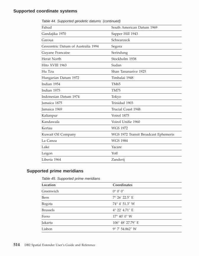
Table 44. Supported geodetic datums (continued)
Fahud South American Datum 1969
Gandajika 1970 Sapper Hill 1943
Garoua Schwarzeck
Geocentric Datum of Australia 1994 Segora
Guyane Francaise Serindung
Herat North Stockholm 1938
Hito XVIII 1963 Sudan
Hu Tzu Shan Tananarive 1925
Hungarian Datum 1972 Timbalai 1948
Indian 1954 TM65
Indian 1975 TM75
Indonesian Datum 1974 Tokyo
Jamaica 1875 Trinidad 1903
Jamaica 1969 Trucial Coast 1948
Kalianpur Voirol 1875
Kandawala Voirol Unifie 1960
Kertau WGS 1972
Kuwait Oil Company WGS 1972 Transit Broadcast Ephemeris
La Canoa WGS 1984
Lake Yacare
Leigon Yoff
Liberia 1964 Zanderij
Supported prime meridians
Table 45. Supported prime meridians
Location Coordinates
Greenwich 0° 0' 0"
Bern 7° 26' 22.5" E
Bogota 74° 4' 51.3" W
Brussels 4° 22' 4.71" E
Ferro 17° 40' 0" W
Jakarta 106° 48' 27.79" E
Lisbon 9° 7' 54.862" W
Supported coordinate systems
514 DB2 Spatial Extender User’s Guide and Reference

Table 45. Supported prime meridians (continued)
Location Coordinates
Madrid 3° 41' 16.58" W
Paris 2° 20' 14.025" E
Rome 12° 27' 8.4" E
Stockholm 18° 3' 29" E
Supported map projections
Table 46. Cylindrical projections
Cylindrical projections Pseudocylindrical projections
Behrmann Craster parabolic
Cassini Eckert I
Cylindrical equal area Eckert II
Equirectangular Eckert III
Gall’s stereographic Eckert IV
Gauss-Kruger Eckert V
Mercator Eckert VI
Miller cylindrical McBryde-Thomas flat polar quartic
Oblique Mercator (Hotine) Mollweide
Plate-Carée Robinson
Times Sinusoidal (Sansom-Flamsteed)
Transverse Mercator Winkel I
Table 47. Conic projections
Albers conic equal-area Chamberlin trimetric
Bipolar oblique conformal conic Two-point equidistant
Bonne Hammer-Aitoff equal-area
Equidistant conic Van der Grinten I
Lambert conformal conic Miscellaneous
Polyconic Alaska series E
Simple conic Alaska Grid (Modified-Stereographic bySnyder)
Supported coordinate systems
Chapter 22. Supported coordinate systems 515

Table 48. Map projection parameters
Parameter Description
central_meridian The line of longitude chosen as the originof x-coordinates.
scale_factor Scale_factor is used generally to reducethe amount of distortion in a mapprojection.
standard_parallel_1 A line of latitude that has no distortiongenerally. Also used for ″latitude of truescale.″
standard_parallel_2 A line of longitude that has no distortiongenerally.
longitude_of_center The longitude that defines the center pointof the map projection.
latitude_of_center The latitude that defines the center pointof the map projection.
longitude_of_origin The longitude chosen as the origin ofx-coordinates.
latitude_of_origin The latitude chosen as the origin ofy-coordinates.
false_easting A value added to x-coordinates so that allx-coordinate values are positive.
false_northing A value added to y-coordinates so that ally-coordinates are positive.
azimuth The angle east of north that defines thecenter line of an oblique projection.
longitude_of_point_1 The longitude of the first point needed fora map projection.
latitude_of_point_1 The latitude of the first point needed for amap projection.
longitude_of_point_2 The longitude of the second point neededfor a map projection.
latitude_of_point_2 The latitude of the second point neededfor a map projection.
longitude_of_point_3 The longitude of the third point neededfor a map projection.
latitude_of_point_3 The latitude of the third point needed fora map projection.
landsat_number The number of a Landsat satellite.
Supported coordinate systems
516 DB2 Spatial Extender User’s Guide and Reference

Table 48. Map projection parameters (continued)
Parameter Description
path_number The orbital path number for a particularsatellite.
perspective_point_height The height above the earth of theperspective point of the map projection.
fipszone State Plane Coordinate System zonenumber.
zone UTM zone number.
Supported coordinate systems
Chapter 22. Supported coordinate systems 517

Reference material
518 DB2 Spatial Extender User’s Guide and Reference
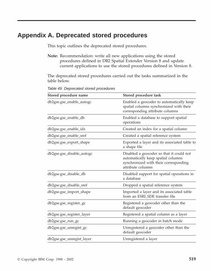
Appendix A. Deprecated stored procedures
This topic outlines the deprecated stored procedures.
Note: Recommendation: write all new applications using the storedprocedures defined in DB2 Spatial Extender Version 8 and updatecurrent applications to use the stored procedures defined in Version 8.
The deprecated stored procedures carried out the tasks summarized in thetable below.
Table 49. Deprecated stored procedures
Stored procedure name Stored procedure task
db2gse.gse_enable_autogc Enabled a geocoder to automatically keepspatial columns synchronized with theircorresponding attribute columns
db2gse.gse_enable_db Enabled a database to support spatialoperations
db2gse.gse_enable_idx Created an index for a spatial column
db2gse.gse_enable_sref Created a spatial reference system
db2gse.gse_export_shape Exported a layer and its associated table toa shape file
db2gse.gse_disable_autogc Disabled a geocoder so that it could notautomatically keep spatial columnssynchronized with their correspondingattribute columns
db2gse.gse_disable_db Disabled support for spatial operations ina database
db2gse.gse_disable_sref Dropped a spatial reference system
db2gse.gse_import_shape Imported a layer and its associated tablefrom an ESRI_SDE transfer file
db2gse.gse_register_gc Registered a geocoder other than thedefault geocoder
db2gse.gse_register_layer Registered a spatial column as a layer
db2gse.gse_run_gc Running a geocoder in batch mode
db2gse.gse_unregist_gc Unregistered a geocoder other than thedefault geocoder
db2gse.gse_unregist_layer Unregistered a layer
© Copyright IBM Corp. 1998 - 2002 519
db2gse.gse_enable_autogc
Use this stored procedure to:v Create triggers that keep a spatial column synchronized with its associated
attribute column or columns. Each time values are inserted into, or updatedin, the attribute column or columns, a trigger calls a registered geocoder togeocode the inserted or updated values and place the resulting data in thespatial column.
v Reactivate the triggers after they are temporarily disabled.v Establish which function to use to geocode the inserted and updated
values.
Authorization:
The user ID under which this stored procedure is invoked must have thefollowing authorities or privileges:v SYSADM or DBADM authority on the database that contains the table on
which the triggers created by this stored procedure are defined.v The CONTROL privilege on this table.v The ALTER, SELECT, and UPDATE privileges on this table.
Parameters:
Table 50. Input parameters for the db2gse.gse_enable_autogc stored procedure.
Name Data type Description
operMode SMALLINT Value that indicates whether the triggers thatinitiate the geocoding are to be created for thefirst time or to be reactivated after beingtemporarily disabled.
This parameter is not nullable.
Comment: To create the triggers, use theGSE_AUTOGC_CREATE macro. To reactivatethem, use the GSE_AUTOGC_RECREATE macro.To find out what values are associated with thesemacros, consult the db2gse.h file. On AIX, thisfile is stored in the$DB2INSTANCE/sqllib/include/ directory. OnWindows NT, it is stored in the%DB2PATH%\include\ directory.
If the operMode parameter is set toGSE_AUTOGC_CREATE, you must assign anidentifier of a registered geocoder to the gcIdparameter.
Deprecated stored procedures
520 DB2 Spatial Extender User’s Guide and Reference

Table 50. Input parameters for the db2gse.gse_enable_autogc storedprocedure. (continued)
Name Data type Description
layerSchema VARCHAR(30) Name of the schema to which the table specifiedin the layerTable parameter belongs.
This parameter is nullable.
If you do not supply a value for the layerSchemaparameter, it will default to the user ID underwhich the db2gse.gse_enable_autogc storedprocedure is invoked.
layerTable VARCHAR(128) Name of the table that the triggers created orreactivated by this stored procedure are tooperate on.
This parameter is not nullable.
layerColumn VARCHAR(128) Name of the spatial column that is to bemaintained by the triggers that this storedprocedure creates or reactivates.
This parameter is not nullable.
The layerColumn parameter must reference acolumn that has been registered as a table layer.
gcId INTEGER Identifier of the geocoder that will be invoked bythe insert and update triggers that this storedprocedure creates or reactivates.
This parameter is not nullable if the operModeparameter is set to GSE_AUTOGC_CREATE. It isnullable if operMode is set toGSE_AUTOGC_RECREATE.
precisionLevel INTEGER The degree to which source data must matchcorresponding reference data in order for thegeocoder to process the source data successfully.
This parameter is not nullable if the operModeparameter is set to GSE_AUTOGC_CREATE. It isnullable if operMode is set toGSE_AUTOGC_RECREATE.
The precision level can range from 1 to 100percent.
Deprecated stored procedures
Appendix A. Deprecated stored procedures 521

Table 50. Input parameters for the db2gse.gse_enable_autogc storedprocedure. (continued)
Name Data type Description
vendorSpecific VARCHAR(256) Technical information provided by the vendor;for example, the path and name of a file that thevendor uses to set parameters.
This parameter is not nullable if the operModeparameter is set to GSE_AUTOGC_CREATE. It isnullable if operMode is set toGSE_AUTOGC_RECREATE.
Results:
Table 51. Output parameters for the db2gse.gse_enable_autogc stored procedure.
Name Data type Description
msgCode INTEGER Code associated with the messages that the callerof this stored procedure can return.
msgText VARCHAR(1024) Complete error message, as constructed at theserver.
db2gse.gse_enable_db
Use this stored procedure to supply a database with the resources that itneeds to store spatial data and to support operations. These resources includespatial data types, a spatial index type, catalog tables and views, suppliedfunctions, and other stored procedures. The external library and functionname for this stored procedure is db2gse.gse_enable_db.
Authorization:
The user ID under which the stored procedure is invoked must have eitherSYSADM or DBADM authority on the database that is being enabled.
Results:
Table 52. Output parameters for the db2gse.gse_enable_db stored procedure.
Name Data type Description
msgCode INTEGER Code associated with the messages that the callerof this stored procedure can return.
msgText VARCHAR(1024) Complete error message, as constructed at theDB2 Spatial Extender server.
Deprecated stored procedures
522 DB2 Spatial Extender User’s Guide and Reference
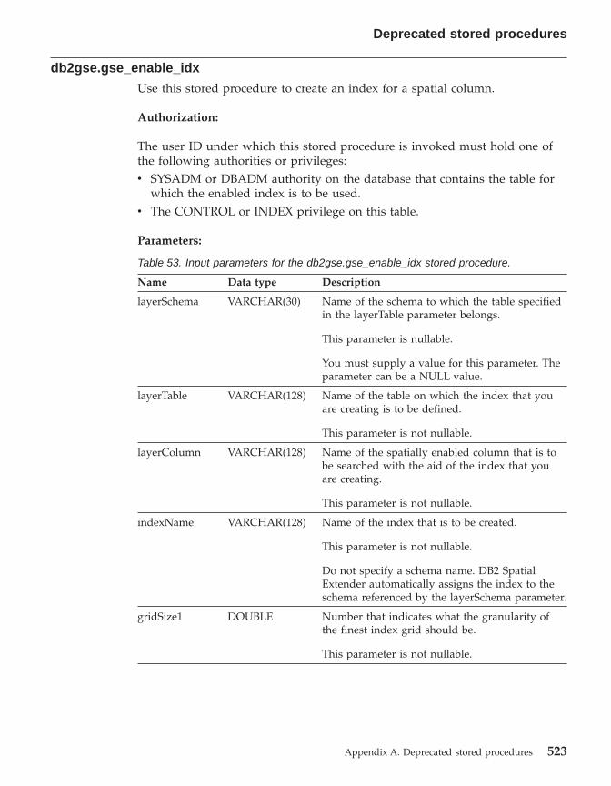
db2gse.gse_enable_idx
Use this stored procedure to create an index for a spatial column.
Authorization:
The user ID under which this stored procedure is invoked must hold one ofthe following authorities or privileges:v SYSADM or DBADM authority on the database that contains the table for
which the enabled index is to be used.v The CONTROL or INDEX privilege on this table.
Parameters:
Table 53. Input parameters for the db2gse.gse_enable_idx stored procedure.
Name Data type Description
layerSchema VARCHAR(30) Name of the schema to which the table specifiedin the layerTable parameter belongs.
This parameter is nullable.
You must supply a value for this parameter. Theparameter can be a NULL value.
layerTable VARCHAR(128) Name of the table on which the index that youare creating is to be defined.
This parameter is not nullable.
layerColumn VARCHAR(128) Name of the spatially enabled column that is tobe searched with the aid of the index that youare creating.
This parameter is not nullable.
indexName VARCHAR(128) Name of the index that is to be created.
This parameter is not nullable.
Do not specify a schema name. DB2 SpatialExtender automatically assigns the index to theschema referenced by the layerSchema parameter.
gridSize1 DOUBLE Number that indicates what the granularity ofthe finest index grid should be.
This parameter is not nullable.
Deprecated stored procedures
Appendix A. Deprecated stored procedures 523

Table 53. Input parameters for the db2gse.gse_enable_idx storedprocedure. (continued)
Name Data type Description
gridSize2 DOUBLE Number that denotes either (1) that there is to beno second grid for this index or (2) what thegranularity of the second grid should be.
This parameter is nullable.
If there is to be no second grid, specify 0. If youwant a second grid, it must be less granular thanthe grid denoted by gridSize1.
gridSize3 DOUBLE Number that denotes either (1) that there is to beno third grid for this index or (2) what thegranularity of the third grid should be.
This parameter is nullable.
If there is to be no third grid, specify 0. If youwant a third grid, it must be less granular thanthe grid denoted by gridSize2.
Results:
Table 54. Output parameters for the db2gse.gse_enable_idx stored procedure.
Name Data type Description
msgCode INTEGER Code associated with the messages that the callerof this stored procedure can return.
msgText VARCHAR(1024) Complete error message, as constructed at theDB2 Spatial Extender server.
db2gse.gse_enable_sref
Use this stored procedure to specify how negative and decimal numbers in aspecific coordinate system are to be converted into positive integers, so thatDB2 Spatial Extender can store them. Your specifications are collectively calleda spatial reference system. When this stored procedure is processed, informationabout the spatial reference system is added to the DB2GSE.SPATIAL_REF_SYScatalog view.
Authorization:
None required.
Deprecated stored procedures
524 DB2 Spatial Extender User’s Guide and Reference
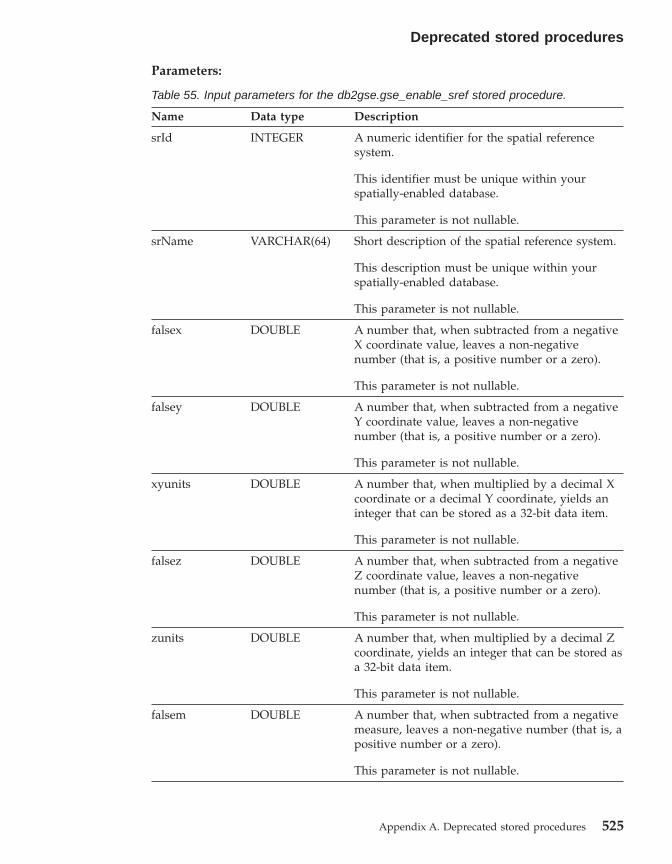
Parameters:
Table 55. Input parameters for the db2gse.gse_enable_sref stored procedure.
Name Data type Description
srId INTEGER A numeric identifier for the spatial referencesystem.
This identifier must be unique within yourspatially-enabled database.
This parameter is not nullable.
srName VARCHAR(64) Short description of the spatial reference system.
This description must be unique within yourspatially-enabled database.
This parameter is not nullable.
falsex DOUBLE A number that, when subtracted from a negativeX coordinate value, leaves a non-negativenumber (that is, a positive number or a zero).
This parameter is not nullable.
falsey DOUBLE A number that, when subtracted from a negativeY coordinate value, leaves a non-negativenumber (that is, a positive number or a zero).
This parameter is not nullable.
xyunits DOUBLE A number that, when multiplied by a decimal Xcoordinate or a decimal Y coordinate, yields aninteger that can be stored as a 32-bit data item.
This parameter is not nullable.
falsez DOUBLE A number that, when subtracted from a negativeZ coordinate value, leaves a non-negativenumber (that is, a positive number or a zero).
This parameter is not nullable.
zunits DOUBLE A number that, when multiplied by a decimal Zcoordinate, yields an integer that can be stored asa 32-bit data item.
This parameter is not nullable.
falsem DOUBLE A number that, when subtracted from a negativemeasure, leaves a non-negative number (that is, apositive number or a zero).
This parameter is not nullable.
Deprecated stored procedures
Appendix A. Deprecated stored procedures 525
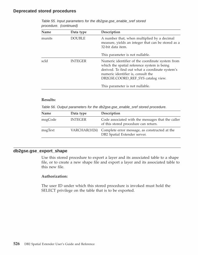
Table 55. Input parameters for the db2gse.gse_enable_sref storedprocedure. (continued)
Name Data type Description
munits DOUBLE A number that, when multiplied by a decimalmeasure, yields an integer that can be stored as a32-bit data item.
This parameter is not nullable.
scId INTEGER Numeric identifier of the coordinate system fromwhich the spatial reference system is beingderived. To find out what a coordinate system’snumeric identifier is, consult theDB2GSE.COORD_REF_SYS catalog view.
This parameter is not nullable.
Results:
Table 56. Output parameters for the db2gse.gse_enable_sref stored procedure.
Name Data type Description
msgCode INTEGER Code associated with the messages that the callerof this stored procedure can return.
msgText VARCHAR(1024) Complete error message, as constructed at theDB2 Spatial Extender server.
db2gse.gse_export_shape
Use this stored procedure to export a layer and its associated table to a shapefile, or to create a new shape file and export a layer and its associated table tothis new file.
Authorization:
The user ID under which this stored procedure is invoked must hold theSELECT privilege on the table that is to be exported.
Deprecated stored procedures
526 DB2 Spatial Extender User’s Guide and Reference
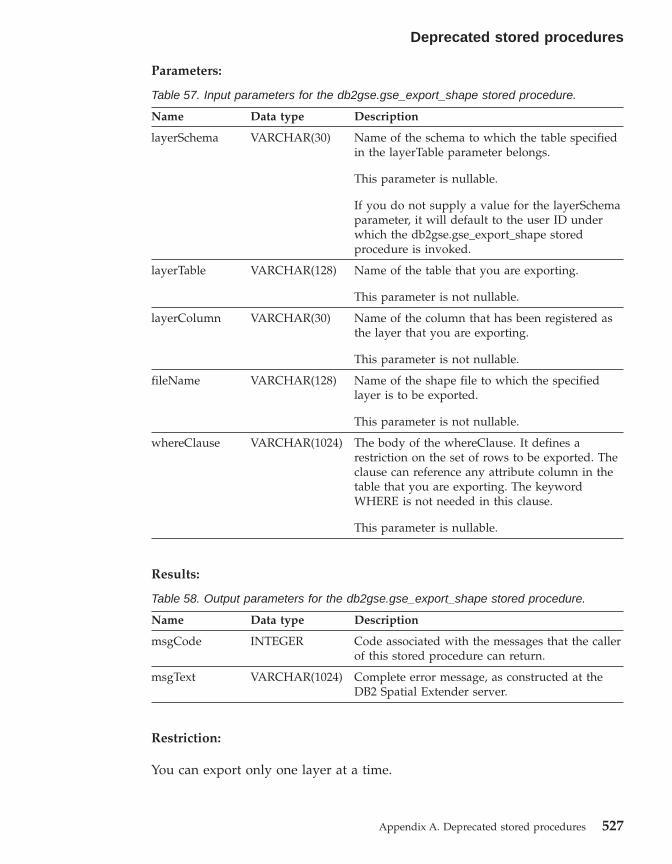
Parameters:
Table 57. Input parameters for the db2gse.gse_export_shape stored procedure.
Name Data type Description
layerSchema VARCHAR(30) Name of the schema to which the table specifiedin the layerTable parameter belongs.
This parameter is nullable.
If you do not supply a value for the layerSchemaparameter, it will default to the user ID underwhich the db2gse.gse_export_shape storedprocedure is invoked.
layerTable VARCHAR(128) Name of the table that you are exporting.
This parameter is not nullable.
layerColumn VARCHAR(30) Name of the column that has been registered asthe layer that you are exporting.
This parameter is not nullable.
fileName VARCHAR(128) Name of the shape file to which the specifiedlayer is to be exported.
This parameter is not nullable.
whereClause VARCHAR(1024) The body of the whereClause. It defines arestriction on the set of rows to be exported. Theclause can reference any attribute column in thetable that you are exporting. The keywordWHERE is not needed in this clause.
This parameter is nullable.
Results:
Table 58. Output parameters for the db2gse.gse_export_shape stored procedure.
Name Data type Description
msgCode INTEGER Code associated with the messages that the callerof this stored procedure can return.
msgText VARCHAR(1024) Complete error message, as constructed at theDB2 Spatial Extender server.
Restriction:
You can export only one layer at a time.
Deprecated stored procedures
Appendix A. Deprecated stored procedures 527

db2gse.gse_disable_autogc
Use this stored procedure to drop or temporarily disable triggers that keep aspatial column synchronized with its associated attribute column or columns.For example, it is advisable to disable the triggers while you geocode thevalues in the attribute column or columns in batch mode.
Authorization:
The user ID under which this stored procedure is invoked must have one ofthe following authorities, privileges, or set of privileges:v SYSADM or DBADM authority on the database that contains the table on
which the triggers that are being dropped or temporarily disabled aredefined.
v The CONTROL privilege on this table.v The ALTER and UPDATE privileges on this table.
Note: For CONTROL and ALTER privileges, you must have DROPINauthority on the DB2GSE schema.
Parameters:
Table 59. Input parameters for the db2gse.gse_disable_autogc stored procedure.
Name Data type Description
operMode SMALLINT Indicates whether the triggers are to be droppedor temporarily disabled.
Dropped triggers have no effect on SQLstatements.
Temporarily disabled triggers can be re-createdwithout having to re-specify previously setparameters.
This parameter is not nullable.
To drop triggers, use the GSE_AUTOGC_DROPmacro. To temporarily disable them, use theGSE_AUTOGC_INVALIDATE macro. To find outwhat values are associated with these macros,consult the db2gse.h file. On AIX, this file isstored in the $DB2INSTANCE/sqllib/include/directory. On Windows NT, it is stored in the%DB2PATH%\include\ directory.
Deprecated stored procedures
528 DB2 Spatial Extender User’s Guide and Reference

Table 59. Input parameters for the db2gse.gse_disable_autogc storedprocedure. (continued)
Name Data type Description
layerSchema VARCHAR(30) Name of the schema to which the table or viewspecified in the layerTable parameter belongs.
This parameter is nullable.
If you do not supply a value for the layerSchemaparameter, it will default to the user ID underwhich the db2gse.gse_disable_autogc storedprocedure is invoked.
layerTable VARCHAR(128) Name of the table on which the triggers that youwant dropped or temporarily disabled aredefined.
This parameter is not nullable.
layerColumn VARCHAR(128) Name of the spatially enabled column that ismaintained by the triggers that you wantdropped or temporarily disabled.
This parameter is not nullable.
Results:
Table 60. Output parameters for the db2gse.gse_disable_autogc stored procedure.
Name Data type Description
msgCode INTEGER Code associated with the messages that the callerof this stored procedure can return.
msgText VARCHAR(1024) Complete error message, as constructed at theDB2 Spatial Extender server.
db2gse.gse_disable_db
Use this stored procedure to remove resources that allow DB2 SpatialExtender to store spatial data and to support operations performed on thisdata.
The purpose of this stored procedure is to help you resolve problems or issuesthat arise after you enable your database for spatial operations, but before youadd any spatial table columns or data to it. For example, if, after you enable adatabase for spatial operations, if you decide to use DB2 Spatial Extender for
Deprecated stored procedures
Appendix A. Deprecated stored procedures 529
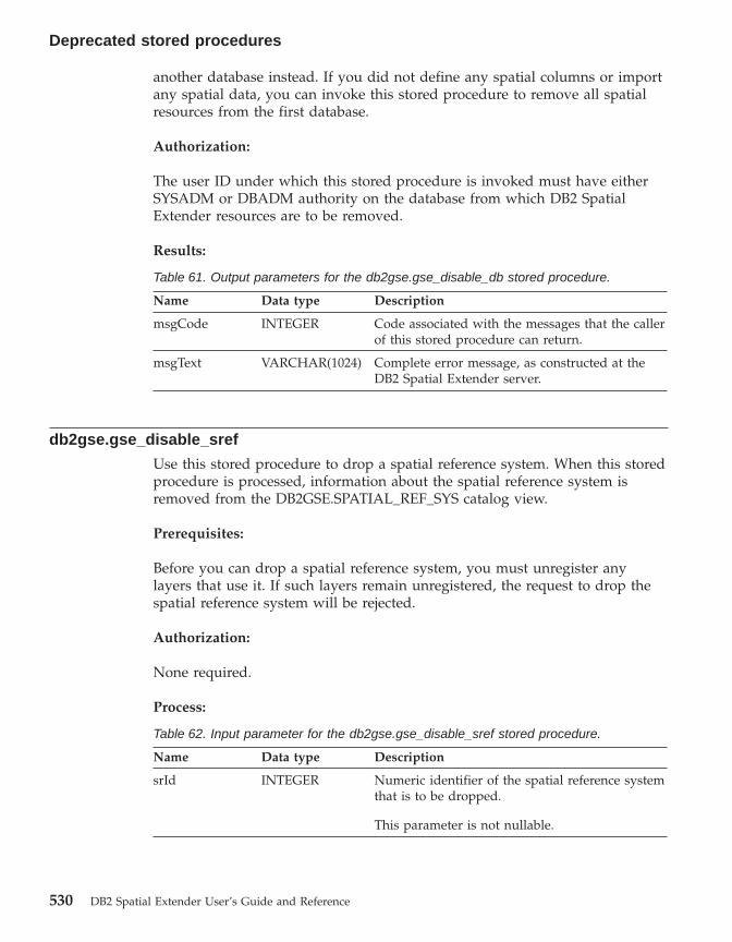
another database instead. If you did not define any spatial columns or importany spatial data, you can invoke this stored procedure to remove all spatialresources from the first database.
Authorization:
The user ID under which this stored procedure is invoked must have eitherSYSADM or DBADM authority on the database from which DB2 SpatialExtender resources are to be removed.
Results:
Table 61. Output parameters for the db2gse.gse_disable_db stored procedure.
Name Data type Description
msgCode INTEGER Code associated with the messages that the callerof this stored procedure can return.
msgText VARCHAR(1024) Complete error message, as constructed at theDB2 Spatial Extender server.
db2gse.gse_disable_sref
Use this stored procedure to drop a spatial reference system. When this storedprocedure is processed, information about the spatial reference system isremoved from the DB2GSE.SPATIAL_REF_SYS catalog view.
Prerequisites:
Before you can drop a spatial reference system, you must unregister anylayers that use it. If such layers remain unregistered, the request to drop thespatial reference system will be rejected.
Authorization:
None required.
Process:
Table 62. Input parameter for the db2gse.gse_disable_sref stored procedure.
Name Data type Description
srId INTEGER Numeric identifier of the spatial reference systemthat is to be dropped.
This parameter is not nullable.
Deprecated stored procedures
530 DB2 Spatial Extender User’s Guide and Reference

Results:
Table 63. Output parameters for the db2gse.gse_disable_sref stored procedure.
Name Data type Description
msgCode INTEGER Code associated with the messages that the callerof this stored procedure can return.
msgText VARCHAR(1024) Complete error message, as constructed at theDB2 Spatial Extender server.
db2gse.gse_import_shape
Use this stored procedure to import an ESRI shape file to a database that isenabled for spatial operations. The stored procedure can operate in either oftwo ways:v If the shape file is targeted for an existing table that has a registered layer
column, DB2 Spatial Extender will load the table with the file’s data.v If the shape file is targeted for a table that does not exist, DB2 Spatial
Extender will create a table that has a spatial column, register this columnas a layer, and load the layer and the table’s other columns with the file’sdata.
When you import a set of ESRI shape representations, you receive at least twofiles. All the files have the same file name prefix, but different extensions. Forexample, the extensions of the two files that you always receive are .shp and.shx.
To receive the files for a set of shape representations, assign the name that thefiles have in common to the fileName parameter. Do not specify an extension.This way, you can be sure that all the files that you need—the .shp file, the.shx file, and any others that might be included—will be imported.
For example, suppose that a set of ESRI shape representations is stored in filescalled Lakes.shp and Lakes.shx. When importing these representations, youwould assign only the name Lakes to the fileName parameter.
SDE transfer files have names but not extensions. Therefore, when importingan SDE transfer file, you assign its name, but no extension, to the fileNameparameter.
Authorization:
The user ID under which this stored procedure is invoked must hold one ofthe following authorities or privileges:
Deprecated stored procedures
Appendix A. Deprecated stored procedures 531

v SYSADM or DBADM authority on the database that contains the table intowhich imported shape data is to be loaded.
v The CONTROL privilege on this table.
Parameters:
Table 64. Input parameters for the db2gse.gse_import_shape stored procedure.
Name Data type Description
layerSchema VARCHAR(30) Name of the schema to which the table or viewspecified in the layerTable parameter belongs.
This parameter is nullable.
If you do not supply a value for the layerSchemaparameter, it will default to the user ID underwhich the db2gse.gse_import_shape storedprocedure is invoked.
layerTable VARCHAR(128) Name of the table into which the imported shapefile is to be loaded.
This parameter is not nullable.
layerColumn VARCHAR(30) Name of the column that has been registered asthe layer into which shape data is to be loaded.
This parameter is not nullable.
fileName VARCHAR(128) Name of the shape file that is to be imported.
This parameter is not nullable.
exceptionFile VARCHAR(128) Path and name of the file in which the shapesthat could not be imported are stored. This is anew file that will be created when thedb2gse.gse_import_shape stored procedure isrun.
Assign a file name, but not an extension, to theexceptionFile parameter
This parameter is not nullable.
srId INTEGER Identifier of the spatial reference system to beused for the layer into which shape data is to beloaded.
This parameter is nullable.
If this identifier is not specified, the internaltransformation will be set to the maximumresolution possible resolution for the shape file.
Deprecated stored procedures
532 DB2 Spatial Extender User’s Guide and Reference

Table 64. Input parameters for the db2gse.gse_import_shape storedprocedure. (continued)
Name Data type Description
commitScope INTEGER Number of records per checkpoint.
This parameter is I was nullable.
Results:
Table 65. Output parameters for the db2gse.gse_import_shape stored procedure.
Name Data type Description
msgCode INTEGER Code associated with the messages that the callerof this stored procedure can return.
msgText VARCHAR(1024) Complete error message, as constructed at theDB2 Spatial Extender server.
db2gse.gse_register_gc
Use this stored procedure to register a geocoder other than the default. Tofind out whether a geocoder is already registered, consult theDB2GSE.SPATIAL_GEOCODER catalog view.
Authorization:
The user ID under which this stored procedure is invoked must hold eitherSYSADM or DBADM authority on the database that contains the geocoderthat this stored procedure registers.
Parameters:
Table 66. Input parameters for the db2gse.gse_register_gc stored procedure.
Name Data type Description
gcId INTEGER Numeric identifier of the geocoder that you areregistering.
This identifier must be unique within thedatabase.
This parameter is not nullable.
Deprecated stored procedures
Appendix A. Deprecated stored procedures 533

Table 66. Input parameters for the db2gse.gse_register_gc storedprocedure. (continued)
Name Data type Description
gcName VARCHAR(64) Short description of the gecoder that you areregistering.
This description must be a unique characterstring within the database.
This parameter is not nullable.
vendorName VARCHAR(64) Name of vendor that supplied the geocoder thatyou are registering.
This parameter is not nullable.
primaryUDF VARCHAR(256) Fully-qualified name of the geocoder that you areregistering.
This parameter is not nullable.
precisionLevel INTEGER The degree to which source data must matchcorresponding reference data in order for thegeocoder to process the source data successfully.
The precision level can range from 1 to 100percent.
This parameter is not nullable.
vendorSpecific VARCHAR(256) Technical information provided by the vendor;for example, the path and name of a file that thevendor uses to set parameters.
This parameter is nullable.
geoArea VARCHAR(256) Geographical area to be geocoded.
This parameter is nullable.
description VARCHAR(256) Remarks provided by the vendor
This parameter is nullable.
Results:
Table 67. Output parameters for the db2gse.gse_register_gc stored procedure.
Name Data type Description
msgCode INTEGER Code associated with the messages that the callerof this stored procedure can return.
Deprecated stored procedures
534 DB2 Spatial Extender User’s Guide and Reference

Table 67. Output parameters for the db2gse.gse_register_gc storedprocedure. (continued)
Name Data type Description
msgText VARCHAR(1024) Complete error message, as constructed at theDB2 Spatial Extender server.
db2gse.gse_register_layer
Use this stored procedure to register a spatial column as a layer. When thisstored procedure is processed, information about the layer being registered isadded to the DB2GSE.GEOMETRY_COLUMNS catalog view.
Authorization:
The user ID under which this stored procedure is invoked must hold one ofthe following authorities or privileges:v For a table layer:
– SYSADM or DBADM authority on the database that contains the table towhich this layer belongs.
– The CONTROL or ALTER privilege on this table.v For a view layer:
– The SELECT privilege on the base table or tables that contain (1) theaddress data that is to be geocoded for this layer and (2) the spatial datathat results from the geocoding.
Parameters:
Table 68. Input parameters for the db2gse.gse_register_layer stored procedure.
Name Data type Description
layerSchema INTEGER(30) Name of the schema to which the table or viewspecified in the layerTable parameter belongs.
This parameter is nullable.
If you do not supply a value for the layerSchemaparameter, it will default to the user ID underwhich the db2gse.gse_register_layer storedprocedure is invoked.
layerTable VARCHAR(128) Name of the table or view that contains thecolumn that is being registered as a layer.
This parameter is not nullable.
Deprecated stored procedures
Appendix A. Deprecated stored procedures 535
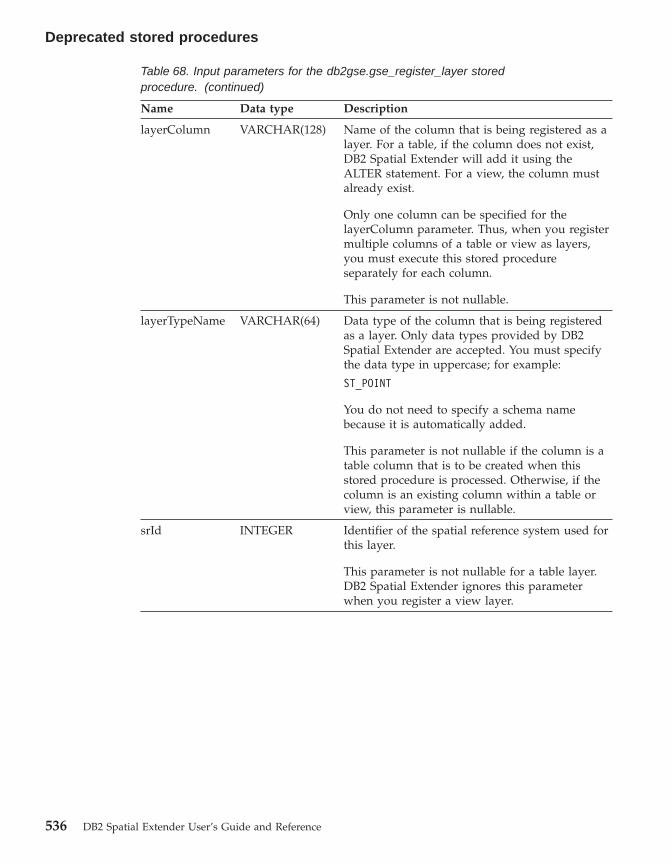
Table 68. Input parameters for the db2gse.gse_register_layer storedprocedure. (continued)
Name Data type Description
layerColumn VARCHAR(128) Name of the column that is being registered as alayer. For a table, if the column does not exist,DB2 Spatial Extender will add it using theALTER statement. For a view, the column mustalready exist.
Only one column can be specified for thelayerColumn parameter. Thus, when you registermultiple columns of a table or view as layers,you must execute this stored procedureseparately for each column.
This parameter is not nullable.
layerTypeName VARCHAR(64) Data type of the column that is being registeredas a layer. Only data types provided by DB2Spatial Extender are accepted. You must specifythe data type in uppercase; for example:
ST_POINT
You do not need to specify a schema namebecause it is automatically added.
This parameter is not nullable if the column is atable column that is to be created when thisstored procedure is processed. Otherwise, if thecolumn is an existing column within a table orview, this parameter is nullable.
srId INTEGER Identifier of the spatial reference system used forthis layer.
This parameter is not nullable for a table layer.DB2 Spatial Extender ignores this parameterwhen you register a view layer.
Deprecated stored procedures
536 DB2 Spatial Extender User’s Guide and Reference
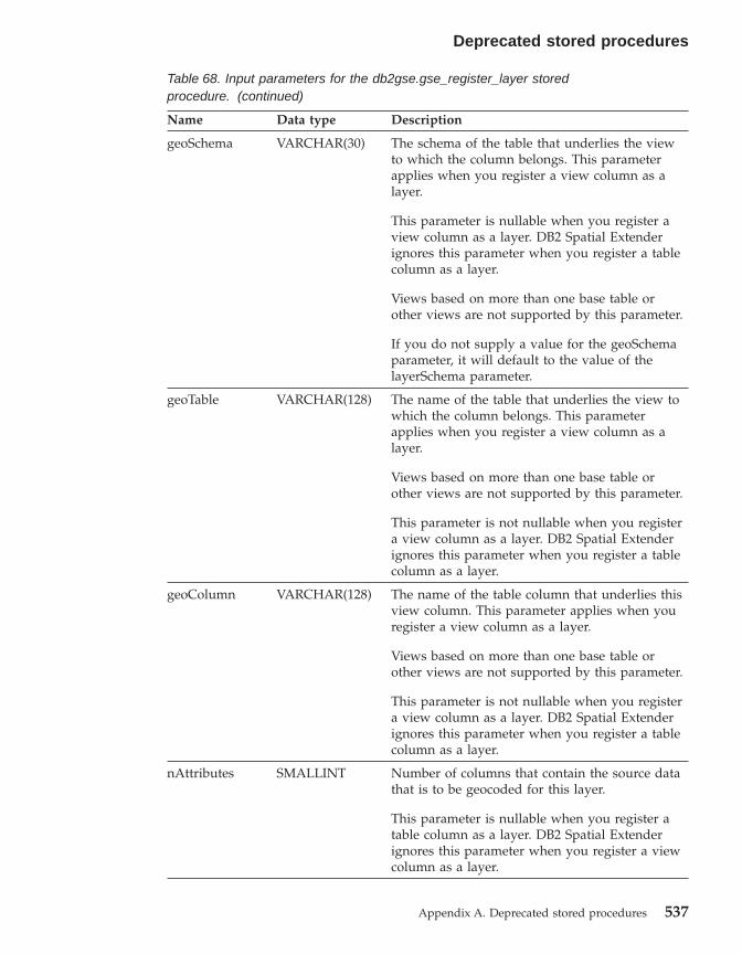
Table 68. Input parameters for the db2gse.gse_register_layer storedprocedure. (continued)
Name Data type Description
geoSchema VARCHAR(30) The schema of the table that underlies the viewto which the column belongs. This parameterapplies when you register a view column as alayer.
This parameter is nullable when you register aview column as a layer. DB2 Spatial Extenderignores this parameter when you register a tablecolumn as a layer.
Views based on more than one base table orother views are not supported by this parameter.
If you do not supply a value for the geoSchemaparameter, it will default to the value of thelayerSchema parameter.
geoTable VARCHAR(128) The name of the table that underlies the view towhich the column belongs. This parameterapplies when you register a view column as alayer.
Views based on more than one base table orother views are not supported by this parameter.
This parameter is not nullable when you registera view column as a layer. DB2 Spatial Extenderignores this parameter when you register a tablecolumn as a layer.
geoColumn VARCHAR(128) The name of the table column that underlies thisview column. This parameter applies when youregister a view column as a layer.
Views based on more than one base table orother views are not supported by this parameter.
This parameter is not nullable when you registera view column as a layer. DB2 Spatial Extenderignores this parameter when you register a tablecolumn as a layer.
nAttributes SMALLINT Number of columns that contain the source datathat is to be geocoded for this layer.
This parameter is nullable when you register atable column as a layer. DB2 Spatial Extenderignores this parameter when you register a viewcolumn as a layer.
Deprecated stored procedures
Appendix A. Deprecated stored procedures 537
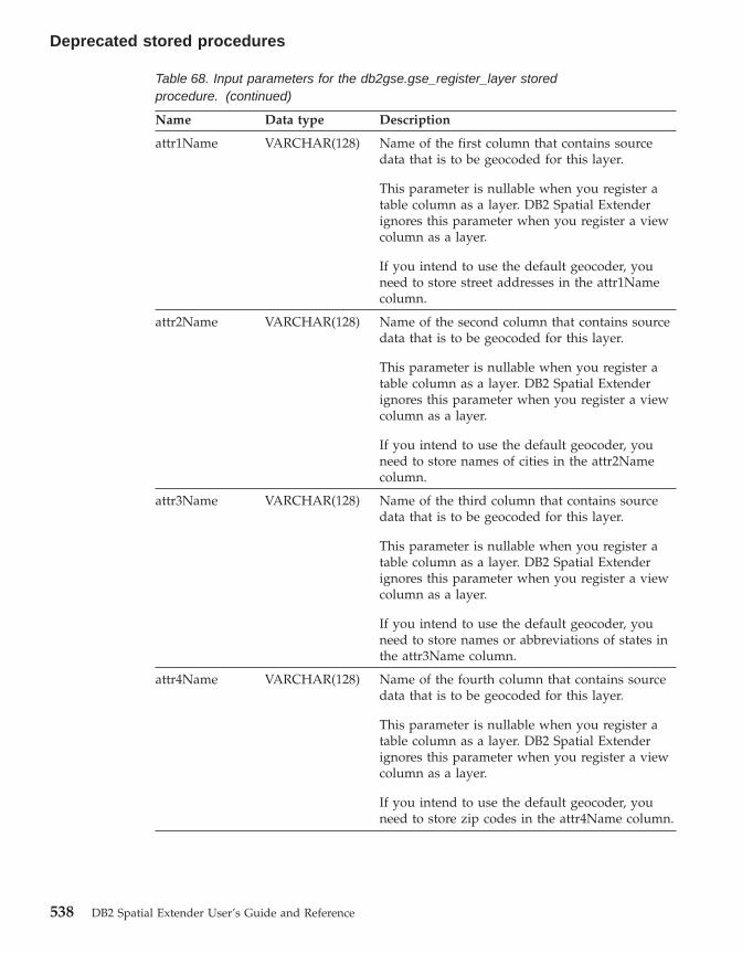
Table 68. Input parameters for the db2gse.gse_register_layer storedprocedure. (continued)
Name Data type Description
attr1Name VARCHAR(128) Name of the first column that contains sourcedata that is to be geocoded for this layer.
This parameter is nullable when you register atable column as a layer. DB2 Spatial Extenderignores this parameter when you register a viewcolumn as a layer.
If you intend to use the default geocoder, youneed to store street addresses in the attr1Namecolumn.
attr2Name VARCHAR(128) Name of the second column that contains sourcedata that is to be geocoded for this layer.
This parameter is nullable when you register atable column as a layer. DB2 Spatial Extenderignores this parameter when you register a viewcolumn as a layer.
If you intend to use the default geocoder, youneed to store names of cities in the attr2Namecolumn.
attr3Name VARCHAR(128) Name of the third column that contains sourcedata that is to be geocoded for this layer.
This parameter is nullable when you register atable column as a layer. DB2 Spatial Extenderignores this parameter when you register a viewcolumn as a layer.
If you intend to use the default geocoder, youneed to store names or abbreviations of states inthe attr3Name column.
attr4Name VARCHAR(128) Name of the fourth column that contains sourcedata that is to be geocoded for this layer.
This parameter is nullable when you register atable column as a layer. DB2 Spatial Extenderignores this parameter when you register a viewcolumn as a layer.
If you intend to use the default geocoder, youneed to store zip codes in the attr4Name column.
Deprecated stored procedures
538 DB2 Spatial Extender User’s Guide and Reference
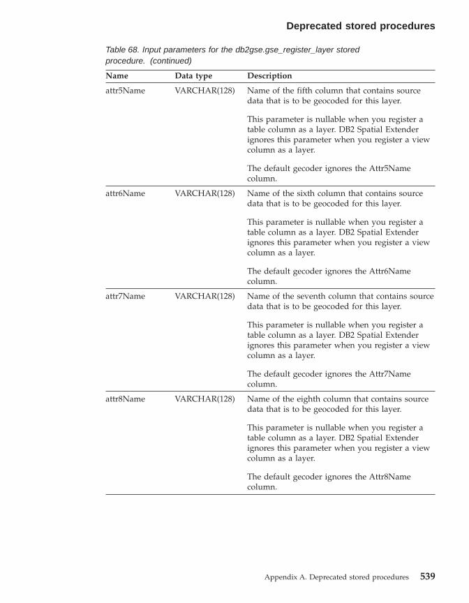
Table 68. Input parameters for the db2gse.gse_register_layer storedprocedure. (continued)
Name Data type Description
attr5Name VARCHAR(128) Name of the fifth column that contains sourcedata that is to be geocoded for this layer.
This parameter is nullable when you register atable column as a layer. DB2 Spatial Extenderignores this parameter when you register a viewcolumn as a layer.
The default gecoder ignores the Attr5Namecolumn.
attr6Name VARCHAR(128) Name of the sixth column that contains sourcedata that is to be geocoded for this layer.
This parameter is nullable when you register atable column as a layer. DB2 Spatial Extenderignores this parameter when you register a viewcolumn as a layer.
The default gecoder ignores the Attr6Namecolumn.
attr7Name VARCHAR(128) Name of the seventh column that contains sourcedata that is to be geocoded for this layer.
This parameter is nullable when you register atable column as a layer. DB2 Spatial Extenderignores this parameter when you register a viewcolumn as a layer.
The default gecoder ignores the Attr7Namecolumn.
attr8Name VARCHAR(128) Name of the eighth column that contains sourcedata that is to be geocoded for this layer.
This parameter is nullable when you register atable column as a layer. DB2 Spatial Extenderignores this parameter when you register a viewcolumn as a layer.
The default gecoder ignores the Attr8Namecolumn.
Deprecated stored procedures
Appendix A. Deprecated stored procedures 539
Table 68. Input parameters for the db2gse.gse_register_layer storedprocedure. (continued)
Name Data type Description
attr9Name VARCHAR(128) Name of the ninth column that contains sourcedata that is to be geocoded for this layer.
This parameter is nullable when you register atable column as a layer. DB2 Spatial Extenderignores this parameter when you register a viewcolumn as a layer.
The default gecoder ignores the Attr9Namecolumn.
attr10Name VARCHAR(128) Name of the tenth column that contains sourcedata that is to be geocoded for this layer.
This parameter is nullable when you register atable column as a layer. DB2 Spatial Extenderignores this parameter when you register a viewcolumn as a layer.
The default gecoder ignores the Attr10Namecolumn.
Results:
Table 69. Output parameters for the db2gse.gse_register_layer stored procedure.
Name Data type Description
msgCode INTEGER Code associated with the messages that the callerof this stored procedure can return.
msgText VARCHAR(1024) Complete error message, as constructed at theDB2 Spatial Extender server.
Restrictions:
This stored procedure does not work on the following table types:v A = Aliasv H = Hierarchy tablev N = Nicknamev S = Summary tablev U = Typed tablev W = Typed view
Deprecated stored procedures
540 DB2 Spatial Extender User’s Guide and Reference

The following restrictions also apply:v If you are registering a view column as a layer, it must be based on a table
column that has already been registered as a layer.v No more than ten attribute columns can contain the data that is to be
geocoded for the layer that you are registering.
db2gse.gse_run_gc
Use this stored procedure to run a geocoder in batch mode.
Authorization:
The user ID under which this stored procedure is invoked must hold one ofthe following authorities or privileges:v SYSADM or DBADM authority on the database that contains the table on
which the specified geocoder is to operate.v The CONTROL or UPDATE privilege on this table.
Parameters:
Table 70. Input parameters for the db2gse.gse_run_gc stored procedure.
Name Data type Description
layerSchema VARCHAR(30) Name of the schema to which the table or viewspecified in the layerTable parameter belongs.
This parameter is nullable.
If you do not supply a value for the layerSchemaparameter, it will default to the user ID underwhich the db2gse.gse_run_gc is invoked.
layerTable VARCHAR(128) Name of the table that contains the column intowhich the geocoded data is to be inserted.
This parameter is not nullable.
layerColumn VARCHAR(128) Name of the column into which the geocodeddata is to be inserted.
This parameter is not nullable.
gcId INTEGER Identifier of the geocoder that you want to run.
This parameter is nullable.
To find the identifiers of registered geocoders,consult the DB2GSE.SPATIAL_GEOCODERcatalog view.
Deprecated stored procedures
Appendix A. Deprecated stored procedures 541

Table 70. Input parameters for the db2gse.gse_run_gc stored procedure. (continued)
Name Data type Description
precisionLevel INTEGER The degree to which source data must matchcorresponding reference data in order for thegeocoder to process the source data successfully.
This parameter is nullable.
The precision level can range from 1 to 100percent.
vendorSpecific VARCHAR(256) Technical information provided by the vendor;for example, the path and name of a file that thevendor uses to set parameters.
This parameter is nullable.
whereClause VARCHAR(256) The body of the WHERE clause. It defines arestriction on the set of records to be geocoded.The clause can reference any attribute column inthe table that the geocoder is to operate on.
This parameter is nullable.
commitScope INTEGER Number of records per checkpoint.
This parameter is nullable.
Results:
Table 71. Output parameters for the db2gse.gse_run_gc stored procedure.
Name Data type Description
msgCode INTEGER Code associated with the messages that the callerof this stored procedure can return.
msgText VARCHAR(1024) Complete error message, as constructed at theDB2 Spatial Extender server.
db2gse.gse_unregist_gc
Use this stored procedure to unregister a geocoder other than the defaultgeocoder. To find information about the geocoder that you want to unregister,consult the DB2GSE.SPATIAL_GEOCODER catalog view.
Authorization:
Deprecated stored procedures
542 DB2 Spatial Extender User’s Guide and Reference

The user ID under which this stored procedure is invoked must hold eitherSYSADM or DBADM authority on the database that contains the geocoderthat is to be unregistered.
Parameters::
Table 72. Input parameter for the db2gse.gse_unregist_gc stored procedure.
Name Data type Description
gcId INTEGER The identifier of the geocoder that is to beunregistered.
This parameter is not nullable.
Results:
Table 73. Output parameters for the db2gse.gse_unregist_gc stored procedure.
Name Data type Description
msgCode INTEGER Code associated with the messages that the callerof this stored procedure can return.
msgText VARCHAR(1024) Complete error message, as constructed at theDB2 Spatial Extender server.
db2gse.gse_unregist_layer
Use this stored procedure to unregister a layer. The stored procedure does thisby:v Removing the definition of the layer from DB2 Spatial Extender catalog
tables.v Deleting the check constraint that DB2 Spatial Extender placed on this
layer’s base table to ensure that the layer’s spatial data conforms to therequirements of the layer’s spatial reference system.
v Dropping the triggers that are used to update the spatial column wheneveraddress data is added, changed, or removed.
When address data in a table row is geocoded, the resulting spatial data isplaced in the same row. Therefore, if the row is deleted, the address data andspatial data are deleted at the same time. Triggers do not delete the spatialdata. When the stored procedure is processed, information about the layer isremoved from the DB2GSE.GEOMETRY_COLUMNS catalog view.
Authorization:
Deprecated stored procedures
Appendix A. Deprecated stored procedures 543
The user ID under which this stored procedure is invoked must hold one ofthe following authorities or privileges:v For a table layer:
– SYSADM or DBADM authority on the database that contains this layer’sbase table.
– The CONTROL or ALTER privilege on this table.v For a view layer:
– The SELECT privilege on the base table or tables that contain (1) theaddress data that is geocoded for this layer and (2) the spatial data thatresults from the geocoding.
Parameters:
Table 74. Input parameters for the db2gse.gse_unregist_layer stored procedure.
Name Data type Description
layerSchema VARCHAR(30) Name of the schema to which the table specifiedin the layerTable parameter belongs.
This parameter is nullable.
If you do not supply a value for the layerSchemaparameter, it will default to the user ID underwhich the db2gse.gse_unregister_layer storedprocedure is invoked.
You must specify in uppercase any schema name,table name, view name, column name, or layername that you assign to a parameter.
layerTable VARCHAR(128) Name of the table that contains the columnspecified in the layerColumn parameter.
This parameter is not nullable.
layerColumn VARCHAR(128) Name of the spatial column that is defined as thelayer that you want to unregister.
This parameter is not nullable.
Only one layer can be specified for thelayerColumn parameter. Thus, when youunregister multiple layers in a table or view, youmust execute this stored procedure separately foreach layer.
Deprecated stored procedures
544 DB2 Spatial Extender User’s Guide and Reference

Results:
Table 75. Output parameters for the db2gse.gse_unregist_layer stored procedure.
Name Data type Description
msgCode INTEGER Code associated with the messages that the callerof this stored procedure can return.
msgText VARCHAR(1024) Complete error message, as constructed at theDB2 Spatial Extender server.
Restriction::
If a view column that has been defined as a view layer is based on a tablecolumn that has been defined as a table layer, you cannot unregister this tablelayer until you unregister the view layer.
Deprecated stored procedures
Appendix A. Deprecated stored procedures 545

Index
546 DB2 Spatial Extender User’s Guide and Reference

Appendix B. Deprecated catalog views
This topic outlines the deprecated catalog views.
Note: Recommendation: Develop all new applications with the views definedin DB2 Spatial Extender Version 8. All current applications should alsobe updated to use the views defined in Version 8. Applications whichreference the undocumented underlying catalog tables defined inVersion 7 will no longer work after migrating to Version 8 and shouldbe modified to use the documented Version 8 catalog views.
DB2GSE.COORD_REF_SYS
When you enable a database for spatial operations, DB2 Spatial Extenderregisters the coordinate systems that you can use in a catalog table. Selectedcolumns from this table comprise the DB2GSE.COORD_REF_SYS catalog view,which is described in the following table.
Table 76. Columns in the DB2GSE.COORD_REF_SYS catalog view
Name Data Type Nullable? Content
CSID INTEGER Yes Unique numeric identifier for this coordinatesystem. If the coordinate system was createdusing the V8 administration interface, then noCSID will be recorded and null is usedinstead
CS_NAME VARCHAR(64) No Name of this coordinate system.
AUTH_NAME VARCHAR(256) Yes Name of the organization that compiled thiscoordinate system adheres to; for example,the European Petroleum Survey Group(EPSG).
AUTH_SRID INTEGER Yes A numeric identifier assigned to thiscoordinate system by the organizationspecified in the AUTH_NAME column.
DESC VARCHAR(256) Yes Description of this coordinate system.
SRTEXT VARCHAR(2048) No Annotation text for this coordinate system.
© Copyright IBM Corp. 1998 - 2002 547

DB2GSE.GEOMETRY_COLUMNS
When you create a layer, DB2 Spatial Extender registers it by recording itsidentifier and information relating to it in a catalog table. Selected columnsfrom this table comprise the DB2GSE.GEOMETRY_COLUMNS catalog view,which is described in the following table.
Table 77. Columns in the DB2GSE.GEOMETRY_COLUMNS catalog view
Name Data Type Nullable? Content
LAYER_CATALOG VARCHAR(30) Yes NULL.
There is no concept of LAYER_CATALOG inDB2 Spatial Extender.
LAYER_SCHEMA VARCHAR(30) No Schema of the table or view that contains thecolumn that was registered as this layer.
LAYER_TABLE VARCHAR(128) No Name of the table or view that contains thecolumn that was registered as this layer.
LAYER_COLUMN VARCHAR(128) No Name of the column that was registered asthis layer.
GEOMETRY_TYPE INTEGER Yes Data type of the column that was registeredas this layer. If the column has a user-definedsubtype of any of the geometry types definedby the spatial extender, then this value will benull
SRID INTEGER No Identifier of the spatial reference system usedfor the values in the column that wasregistered as this layer.
STORAGE_TYPE INTEGER Yes NULL.
DB2GSE.SPATIAL_GEOCODER
Available geocoders are registered in a catalog table. Selected columns fromthis table comprise the DB2GSE.SPATIAL_GEOCODER catalog view, which isdescribed in the following table.
Table 78. Columns in the DB2GSE.SPATIAL_GEOCODER catalog view
Name Data Type Nullable? Content
GCID INTEGER No Numeric identifier of the geocoder.
GC_NAME VARCHAR(64) No Name identifier of the geocoder.
VENDOR_NAME VARCHAR(128) No Name of the vendor that provided thegeocoder.
PRIMARY_UDF VARCHAR(256) No Fully qualified name of the geocoder.
Deprecated catalog views
548 DB2 Spatial Extender User’s Guide and Reference

Table 78. Columns in the DB2GSE.SPATIAL_GEOCODER catalog view (continued)
Name Data Type Nullable? Content
PRECISION_LEVEL INTEGER No The degree to which source data must matchcorresponding reference data in order to beprocessed successfully by the geocoder.
VENDOR_SPECIFIC VARCHAR(256) Yes Path to, and name of, a file a vendor can useto set any special parameters the geocodersupports.
GEO_AREA VARCHAR(256) Yes Geographical area containing the locations tobe geocoded.
DESCRIPTION VARCHAR(256) Yes Description of the geocoder.
DB2GSE.SPATIAL_REF_SYS
When you create a spatial reference system, DB2 Spatial Extender registers itby recording its identifier and information related to it in a catalog table.Selected columns from this table comprise the DB2GSE.SPATIAL_REF_SYScatalog view, which is described in the following table.
Table 79. Columns in the DB2GSE.SPATIAL_REF_SYS catalog view
Name Data Type Nullable? Content
SRID INTEGER No User-defined identifier for this spatialreference system.
SR_NAME VARCHAR(64) No Name of this spatial reference system.
CSID INTEGER No Numeric identifier for the coordinate systemthat underlies this spatial reference system.
CS_NAME VARCHAR(64) No Name of the coordinate system that underliesthis spatial reference system.
AUTH_NAME VARCHAR(256) Yes Name of the organization that sets thestandards for this spatial reference system.
AUTH_SRID INTEGER Yes The identifier that the organization specifiedin the AUTH_NAME column assigns to thisspatial reference system.
SRTEXT VARCHAR(2048) No Annotation text for this spatial referencesystem.
FALSEX FLOAT No A number that, when subtracted from anegative X coordinate value, leaves anon-negative number (that is, a positivenumber or a zero).
Deprecated catalog views
Appendix B. Deprecated catalog views 549
Table 79. Columns in the DB2GSE.SPATIAL_REF_SYS catalog view (continued)
Name Data Type Nullable? Content
FALSEY FLOAT No A number that, when subtracted from anegative Y coordinate value, leaves anon-negative number (that is, a positivenumber or a zero).
XYUNITS FLOAT No A number that, when multiplied by a decimalX coordinate or a decimal Y coordinate, yieldsan integer that can be stored as a 32–bit dataitem.
FALSEZ FLOAT No A number that, when subtracted from anegative Z coordinate value, leaves anon-negative number (that is, a positivenumber or a zero).
ZUNITS FLOAT No A number that, when multiplied by a decimalZ coordinate, yields an integer that can bestored as a 32–bit data item.
FALSEM FLOAT No A number that, when subtracted from anegative measure, leaves a non-negativenumber (that is, a positive number or a zero).
MUNITS FLOAT No A number that, when multiplied by a decimalmeasure, yields an integer that can be storedas a 32–bit data item.
Deprecated catalog views
550 DB2 Spatial Extender User’s Guide and Reference
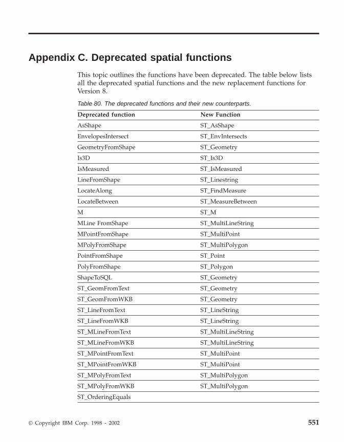
Appendix C. Deprecated spatial functions
This topic outlines the functions have been deprecated. The table below listsall the deprecated spatial functions and the new replacement functions forVersion 8.
Table 80. The deprecated functions and their new counterparts.
Deprecated function New Function
AsShape ST_AsShape
EnvelopesIntersect ST_EnvIntersects
GeometryFromShape ST_Geometry
Is3D ST_Is3D
IsMeasured ST_IsMeasured
LineFromShape ST_Linestring
LocateAlong ST_FindMeasure
LocateBetween ST_MeasureBetween
M ST_M
MLine FromShape ST_MultiLineString
MPointFromShape ST_MultiPoint
MPolyFromShape ST_MultiPolygon
PointFromShape ST_Point
PolyFromShape ST_Polygon
ShapeToSQL ST_Geometry
ST_GeomFromText ST_Geometry
ST_GeomFromWKB ST_Geometry
ST_LineFromText ST_LineString
ST_LineFromWKB ST_LineString
ST_MLineFromText ST_MultiLineString
ST_MLineFromWKB ST_MultiLineString
ST_MPointFromText ST_MultiPoint
ST_MPointFromWKB ST_MultiPoint
ST_MPolyFromText ST_MultiPolygon
ST_MPolyFromWKB ST_MultiPolygon
ST_OrderingEquals
© Copyright IBM Corp. 1998 - 2002 551

Table 80. The deprecated functions and their new counterparts. (continued)
ST_Point(Double, Double, db2gse.coordref) ST_Point(Double, Double, Integer)
ST_PointFromText ST_Point
ST_PolyFromText ST_Polygon
ST_PolyFromWKB ST_Polygon
ST_Transform(Double, Double,db2gse.coordref)
ST_Transform(ST_Geometry, Integer)
ST_SymmetricDiff ST_SymDifference
Z ST_Z
AsShape
Purpose:
AsShape takes a geometry object and returns a BLOB.
Format:
db2gse.AsShape(g db2gse.ST_Geometry)
Results:
BLOB(1m)
EnvelopesIntersect
Purpose:
EnvelopesIntersect returns 1 if the envelopes of two geometries intersect;otherwise it returns 0.
Format:
db2gse.EnvelopesIntersect(g1 db2gse.ST_Geometry, g2 db2gse.ST_Geometry)
Results:
Integer
Deprecated spatial functions
552 DB2 Spatial Extender User’s Guide and Reference

GeometryFromShape
Purpose:
GeometryFromShape takes a shape and a spatial reference system identifier toreturn a geometry object.
Format:
db2gse.GeometryFromShape(ShapeGeometry Blob(1M), SRID db2gse.coordref)
Results:
db2gse.ST_Geometry
Is3d
Purpose:
Is3d takes a geometry object and returns 1 if the object has 3D coordinates;otherwise, it returns 0.
Format:
db2gse.Is3d(g db2gse.ST_Geometry)
Results:
Integer
IsMeasured
Purpose:
IsMeasured takes a geometry object and returns 1 if the object has measures;otherwise it returns 0.
Format:
db2gse.IsMeasured(g db2gse.ST_Geometry)
Results:
Integer
Deprecated spatial functions
Appendix C. Deprecated spatial functions 553
LineFromShape
Purpose:
LineFromShape takes a shape of type point and a spatial reference systemidentifier and returns a linestring.
Format:
db2gse.Line FromShape(ShapeLineString Blob(1M), SRID db2gse.coordref)
Results:
db2gse.ST_LineString
LocateAlong
Purpose:
LocateAlong takes a geometry object and a measure to return as a multipointthe set of points found at the measure.
If LocateAlong is given a multipoint and a measure as input, and if themultipoint does not include this measure, then LocateAlong returns POINTEMPTY.
Format:
db2gse.LocateAlong(g db2gse.ST_Geometry, measure Double)
Results:
db2gse.ST_Geometry
LocateBetween
Purpose:
LocateBetween takes a geometry object and two measure locations and returnsa geometry that represents the set of disconnected paths between the twomeasure locations.
Format:
Deprecated spatial functions
554 DB2 Spatial Extender User’s Guide and Reference

db2gse.LocateBetween(g db2gse.ST_Geometry, measure Double, measureDouble)
Results:
db2gse.ST_Geometry
M
Purpose:
M takes a point and returns its measure.
Format:
db2gse.M(p db2gse.ST_Point)
Results:
Double
MLine FromShape
Purpose:
MLine FromShape takes a shape of type multilinestring and a spatial referencesystem identifier and returns a multilinestring.
Format:
db2gse.MLineFromShape(ShapeMultiLineString Blob(1M), SRIDdb2gse.coordref)
Results:
db2gse.ST_MultiLineString
MPointFromShape
Purpose:
Deprecated spatial functions
Appendix C. Deprecated spatial functions 555

MPointFromShape takes a shape of type multipoint and a spatial referencesystem identifier to return a multipoint.
Format:
db2gse.MPointFromShape(ShapeMultiPoint BLOB(1M), SRID db2gse.coordref)
Results:
db2gse.ST_MultiPoint
MPolyFromShape
Purpose:
MPolyFromShape takes a shape of type multipolygon and a spatial referencesystem identifier to return a multipolygon.
Format:
db2gse.MPolyFromShape(ShapeMultiPolygon Blob(1m), SRID db2gse.coordref)
Results:
db2gse.ST_MultiPolygon
PointFromShape
Purpose:
PointFromShape takes a shape of type point and a spatial reference systemidentifier to return a point.
Format:
db2gse.PointFromShape(db2gse.ShapePoint blob(1M), SRID db2gse.coordref)
Results:
db2gse.ST_Point
PolyFromShape
Purpose:
Deprecated spatial functions
556 DB2 Spatial Extender User’s Guide and Reference

PolyFromShape takes a shape of type polygon and a spatial reference systemidentifier to return a polygon.
Format:
db2gse.PolyFromShape (ShapePolygon Blob(1M), SRID db2gse.coordref)
Results:
db2gse.ST_Polygon
ShapeToSQL
Purpose:
ShapeToSQL constructs a db2gse.ST_Geometry value given its shaperepresentation. The SRID value of 0 is automatically used.
Format:
db2gse.ShapeToSQL(ShapeGeometry blob(1M))
Results:
db2gse.ST_Geometry
ST_GeomFromText
Purpose:
ST_GeomFromText takes a well-known text representation and a spatialreference system identifier and returns a geometry object.
Format:
db2gse.ST_GeomFromText(geometryTaggedText Varchar(4000), SRIDdb2gse.coordref)
Results:
db2gse.ST_Geometry
Deprecated spatial functions
Appendix C. Deprecated spatial functions 557

ST_GeomFromWKB
Purpose:
ST_GeomFromWKB takes a well-known binary representation and a spatialreference system identifier and returns a geometry object.
Format:
db2gse.ST_GeomFromWKB(WKBGeometry Blob(1M), SRID db2gse.coordref)
Results:
db2gse.ST_Geometry
ST_LineFromText
Purpose:
ST_LineFromText takes a well-known text representation of type linestringand a spatial reference system identifier and returns a linestring.
Format:
db2gse.ST_LineFromText(lineStringTaggedText Varchar(4000), SRIDdb2gse.coordref)
Results:
db2gse.ST_LineString
ST_LineFromWKB
Purpose:
ST_LineFromWKB takes a well-known binary representation of the typelinestring and a spatial reference system identifier, and returns a linestring.
Format:
db2gse.ST_LineFromWKB(WKBLineString Blob(1M), SRID db2gse.coordref)
Results:
Deprecated spatial functions
558 DB2 Spatial Extender User’s Guide and Reference

db2gse.ST_LineString
ST_MLineFromText
Purpose:
ST_MLineFromText takes a well-known text representation of typemultilinestring and a spatial reference system identifier and returns amultilinestring.
Format:
db2gse.ST_MLineFromText(multiLineStringTaggedText String, SRIDdb2gse.coordref)
Results:
db2gse.ST_MultiLineString
ST_MLineFromWKB
Purpose:
ST_MLineFromWKB takes a well-known binary representation of typemultilinestring and a spatial reference system identifier and returns amultilinestring.
Format:
db2gse.ST_MLineFromWKB(WKBMultiLineString Blob(1M), SRIDdb2gse.coordref)
Results:
db2gse.ST_MultiLineString
ST_MPointFromText
Purpose:
ST_MPointFromText takes a well-known text representation of type multipointand a spatial reference system identifier and returns a multipoint.
Format:
Deprecated spatial functions
Appendix C. Deprecated spatial functions 559

db2gse.ST_MPointFromText(multiPointTaggedText Varchar(4000), SRIDdb2gse.coordref)
Results:
db2gse.ST_MultiPoint
ST_MPointFromWKB
Purpose:
ST_MPointFromWKB takes a well-known binary representation of typemultipoint and a spatial reference system identifier to return a multipoint.
Format:
db2gse.ST_MPointFromWKB(WKBMultiPoint Blob(1M), SRID db2gse.coordref)
Results:
db2gse.ST_MultiPoint
ST_MPolyFromText
Purpose:
ST_MPolyFromText takes a well-known text representation of typemultipolygon and a spatial reference system identifier and returns amultipolygon.
This function cannot take as input a multipolygon that contains multiplepolygons with the same coordinates.
Format:
db2gse.ST_MPolyFromText(multiPolygonTaggedText Varchar(4000), SRIDdb2gse.coordref)
Results:
db2gse.ST_MultiPolygon
Deprecated spatial functions
560 DB2 Spatial Extender User’s Guide and Reference
ST_MPolyFromWKB
Purpose:
ST_MPolyFromWKB takes a well-known binary representation of typemultipolygon and a spatial reference system identifier and returns amultipolygon.
Format:
db2gse.ST_MPolyFromWKB(WKBMultiPolygon Blob(1M), SRIDdb2gse.coordref)
Results:
db2gse.ST_MultiPolygon
ST_OrderingEquals
Purpose:
ST_OrderingEquals compares two geometries and returns 1 (TRUE) if thegeometries are equal and the coordinates are in the same order; otherwise itreturns 0 (FALSE).
Format:
db2gse.ST_OrderingEquals(g1 db2gse.ST_Geometry, g2 db2gse.ST_Geometry)
Results:
Integer
ST_Point
Purpose:
ST_Point returns an ST_Point, given an x-coordinate, y-coordinate, and spatialreference.
Format:
db2gse.ST_Point(X Double, Y Double, SRID db2gse.coordref)
Deprecated spatial functions
Appendix C. Deprecated spatial functions 561

Results:
db2gse.ST_Point
ST_PointFromText
Purpose:
ST_PointFromText takes a well-known text representation of type point and aspatial reference system identifier and returns a point.
Format:
db2gse.ST_PointFromText(pointTaggedText Varchar(4000), SRIDdb2gse.coordref)
Results:
db2gse.ST_Point
ST_PolyFromText
Purpose:
ST_PolyFromText takes a well-known text representation of type polygon anda spatial reference system identifier and returns a polygon.
Format:
db2gse.ST_PolyFromText(polygonTaggedText Varchar(4000), SRIDdb2gse.coordref)
Results:
db2gse.ST_Polygon
ST_PolyFromWKB
Purpose:
ST_PolyFromWKB takes a well-known binary representation of type polygonand a spatial reference system identifier to return a polygon.
Format:
Deprecated spatial functions
562 DB2 Spatial Extender User’s Guide and Reference
db2gse.ST_PolyFromWKB(WKBPolygon Blob(1M), SRID db2gse.coordref)
Results:
db2gse.ST_Polygon
ST_Transform
Purpose:
ST_Transform associates a geometry to a spatial reference system other thanthe spatial reference system to which the geometry is currently associated.
Format:
db2gse.ST_Transform(g db2gse.ST_Geometry, SRID db2gse.coordref)
Results:
db2gse.ST_Geometry
ST_SymmetricDiff
Purpose:
ST_SymmetricDiff takes two geometry objects and returns a geometry objectthat is the symmetrical difference of the source objects.
The ST_SymmetricDiff function returns the symmetric difference (the Booleanlogical XOR of space) of two intersecting geometries that have the samedimension. If these geometries are equal, ST_SymmetricDiff returns an emptygeometry. If they are not equal, then a portion of one or both of them will lieoutside the area of intersection. ST_SymmetricDiff returns the non-intersectionportion or portions as a collection; for example, as a multipolygon.
If ST_SymmetricDiff is given geometries of different dimensions as input, itreturns a null.
Format:
db2gse.ST_SymmetricDiff(g1 db2gse.ST_Geometry, g2 db2gse.ST_Geometry)
Results:
Deprecated spatial functions
Appendix C. Deprecated spatial functions 563

db2gse.ST_Geometry
Z
Purpose:
Z takes a point and returns its Z coordinate.
Format:
db2gse.Z(p db2gse.ST_Point)
Results:
Double
Related reference:
v “ST_AsShape” on page 300v “ST_MeasureBetween, ST_LocateBetween” on page 397v “ST_EnvIntersects” on page 333v “ST_FindMeasure or ST_LocateAlong” on page 341v “ST_Geometry” on page 351v “ST_Is3d” on page 366v “ST_LineString” on page 381v “ST_M” on page 384v “ST_MultiLineString” on page 418v “ST_MultiPoint” on page 420v “ST_MultiPolygon” on page 422v “ST_Point” on page 437v “ST_Polygon” on page 449v “ST_SymDifference” on page 460v “ST_Transform” on page 473v “ST_Z” on page 485
Deprecated spatial functions
564 DB2 Spatial Extender User’s Guide and Reference

Notices
Index entries
IBM may not offer the products, services, or features discussed in thisdocument in all countries. Consult your local IBM representative forinformation on the products and services currently available in your area. Anyreference to an IBM product, program, or service is not intended to state orimply that only that IBM product, program, or service may be used. Anyfunctionally equivalent product, program, or service that does not infringeany IBM intellectual property right may be used instead. However, it is theuser’s responsibility to evaluate and verify the operation of any non-IBMproduct, program, or service.
IBM may have patents or pending patent applications covering subject matterdescribed in this document. The furnishing of this document does not giveyou any license to these patents. You can send license inquiries, in writing, to:
IBM Director of LicensingIBM CorporationNorth Castle DriveArmonk, NY 10504-1785U.S.A.
For license inquiries regarding double-byte (DBCS) information, contact theIBM Intellectual Property Department in your country/region or sendinquiries, in writing, to:
IBM World Trade Asia CorporationLicensing2-31 Roppongi 3-chome, Minato-kuTokyo 106, Japan
The following paragraph does not apply to the United Kingdom or anyother country/region where such provisions are inconsistent with local law:INTERNATIONAL BUSINESS MACHINES CORPORATION PROVIDES THISPUBLICATION “AS IS” WITHOUT WARRANTY OF ANY KIND, EITHEREXPRESS OR IMPLIED, INCLUDING, BUT NOT LIMITED TO, THEIMPLIED WARRANTIES OF NON-INFRINGEMENT, MERCHANTABILITY,OR FITNESS FOR A PARTICULAR PURPOSE. Some states do not allowdisclaimer of express or implied warranties in certain transactions; therefore,this statement may not apply to you.
© Copyright IBM Corp. 1998 - 2002 565

This information could include technical inaccuracies or typographical errors.Changes are periodically made to the information herein; these changes willbe incorporated in new editions of the publication. IBM may makeimprovements and/or changes in the product(s) and/or the program(s)described in this publication at any time without notice.
Any references in this information to non-IBM Web sites are provided forconvenience only and do not in any manner serve as an endorsement of thoseWeb sites. The materials at those Web sites are not part of the materials forthis IBM product, and use of those Web sites is at your own risk.
IBM may use or distribute any of the information you supply in any way itbelieves appropriate without incurring any obligation to you.
Licensees of this program who wish to have information about it for thepurpose of enabling: (i) the exchange of information between independentlycreated programs and other programs (including this one) and (ii) the mutualuse of the information that has been exchanged, should contact:
IBM Canada LimitedOffice of the Lab Director8200 Warden AvenueMarkham, OntarioL6G 1C7CANADA
Such information may be available, subject to appropriate terms andconditions, including in some cases payment of a fee.
The licensed program described in this document and all licensed materialavailable for it are provided by IBM under terms of the IBM CustomerAgreement, IBM International Program License Agreement, or any equivalentagreement between us.
Any performance data contained herein was determined in a controlledenvironment. Therefore, the results obtained in other operating environmentsmay vary significantly. Some measurements may have been made ondevelopment-level systems, and there is no guarantee that thesemeasurements will be the same on generally available systems. Furthermore,some measurements may have been estimated through extrapolation. Actualresults may vary. Users of this document should verify the applicable data fortheir specific environment.
Information concerning non-IBM products was obtained from the suppliers ofthose products, their published announcements, or other publicly availablesources. IBM has not tested those products and cannot confirm the accuracyof performance, compatibility, or any other claims related to non-IBM
566 DB2 Spatial Extender User’s Guide and Reference

products. Questions on the capabilities of non-IBM products should beaddressed to the suppliers of those products.
All statements regarding IBM’s future direction or intent are subject to changeor withdrawal without notice, and represent goals and objectives only.
This information may contain examples of data and reports used in dailybusiness operations. To illustrate them as completely as possible, the examplesinclude the names of individuals, companies, brands, and products. All ofthese names are fictitious, and any similarity to the names and addresses usedby an actual business enterprise is entirely coincidental.
COPYRIGHT LICENSE:
This information may contain sample application programs, in sourcelanguage, which illustrate programming techniques on various operatingplatforms. You may copy, modify, and distribute these sample programs inany form without payment to IBM for the purposes of developing, using,marketing, or distributing application programs conforming to the applicationprogramming interface for the operating platform for which the sampleprograms are written. These examples have not been thoroughly tested underall conditions. IBM, therefore, cannot guarantee or imply reliability,serviceability, or function of these programs.
Each copy or any portion of these sample programs or any derivative workmust include a copyright notice as follows:
© (your company name) (year). Portions of this code are derived from IBMCorp. Sample Programs. © Copyright IBM Corp. _enter the year or years_. Allrights reserved.
Notices 567

Trademarks
The following terms are trademarks of International Business MachinesCorporation in the United States, other countries, or both, and have been usedin at least one of the documents in the DB2 UDB documentation library.
ACF/VTAMAISPOAIXAIXwindowsAnyNetAPPNAS/400BookManagerC Set++C/370CICSDatabase 2DataHubDataJoinerDataPropagatorDataRefresherDB2DB2 ConnectDB2 ExtendersDB2 OLAP ServerDB2 Universal DatabaseDistributed Relational
Database ArchitectureDRDAeServerExtended ServicesFFSTFirst Failure Support TechnologyIBMIMSIMS/ESAiSeries
LAN DistanceMVSMVS/ESAMVS/XANet.DataNetViewOS/390OS/400PowerPCpSeriesQBICQMFRACFRISC System/6000RS/6000S/370SPSQL/400SQL/DSSystem/370System/390SystemViewTivoliVisualAgeVM/ESAVSE/ESAVTAMWebExplorerWebSphereWIN-OS/2z/OSzSeries
The following terms are trademarks or registered trademarks of othercompanies and have been used in at least one of the documents in the DB2UDB documentation library:
Microsoft, Windows, Windows NT, and the Windows logo are trademarks ofMicrosoft Corporation in the United States, other countries, or both.
Intel and Pentium are trademarks of Intel Corporation in the United States,other countries, or both.
568 DB2 Spatial Extender User’s Guide and Reference

Java and all Java-based trademarks are trademarks of Sun Microsystems, Inc.in the United States, other countries, or both.
UNIX is a registered trademark of The Open Group in the United States andother countries.
Other company, product, or service names may be trademarks or servicemarks of others.
related links
Notices 569

570 DB2 Spatial Extender User’s Guide and Reference

Index
AAPP_CTL_HEAP_SZ parameter,
tuning 53APPLHEAPSZ configuration
parametertuning 53
application control heap sizeconfiguration parameter 53
application heap size parameter(APPLHEAPSZ) 53
applicationssample program 134spatial 131spatial applications
including header files 131Spatial Extender
calling stored procedures 132ArcExplorer
downloading 45using as interface 119
AsShape, deprecated spatialfunction 551
Ccatalog views
ST_COORDINATE_SYSTEMS 229
ST_GEOCODER_PARAMETERS 232
ST_GEOCODERS 233ST_GEOCODING 234ST_GEOCODING_
PARAMETERS 236ST_GEOMETRY_
COLUMNS 231ST_SIZINGS 238ST_SPATIAL_
REFERENCE_SYSTEMS 238ST_UNITS_OF_ MEASURE 242
command line processor (CLP)messages 150
configuration parametersspatial applications
tuning 53values 53
Control Centermessages 153
COORD_REF_SYS, spatialdeprecated catalog view 547
coordinate systems 507angular units 507creating 73description 65geodetic datums 507linear units 507map projections 507prime meridians 507selecting 73spheroids 507ST_COORDINATE_ SYSTEMS
catalog view 229ST_SPATIAL_
REFERENCE_SYSTEMS catalogview 238
Ddata formats
Geography Markup Language(GML) 505
shape representation 505well-known binary (WKB)
representation 503well-known text (WKT)
representation 497data maps
Spatial Extender 47database
enabling spatial operations 60database configuration parameters
spatial applicationsAPP_CTL_HEAP_SZ
parameter 53APPLHEAPSZ parameter 53LOGFILSZ parameter 53LOGPRIMARY parameter 53LOGSECOND parameter 53tuning 53
database manager configurationparameter, tuning for spatial
applications 53databases
configuring for spatialapplications 53
enabling for spatial operationsdiscussion 59
setting up for spatialapplications 53
db2diag.log 155db2se commands 123
db2trc command 154downloading ArcExplorer 45
Eenabling
spatial operations 60EnvelopesIntersect, deprecated
spatial function 551exporting data
SDE transfer files 95shape files 94
Ffunction messages 148
Ggeocoders
description 96reference data 45registering 62running in batch mode 102ST_GEOCODER_ PARAMETERS
catalog view 232ST_GEOCODERS catalog
view 233ST_GEOCODING catalog
view 234ST_GEOCODING_
PARAMETERS catalogview 236
ST_SIZINGS catalog view 238geocoding
batch mode 102geographic features
description 3represented by data 4
Geographic Markup Language(GML), data format 505
geometriesdiscussion 11properties 13
GEOMETRY_COLUMNS, spatialdeprecated catalog view 547
GeometryFromShape, deprecatedspatial function 551
grid indexescreating 106
gse_disable_autogc storedprocedure 182
© Copyright IBM Corp. 1998 - 2002 571

gse_disable_autogc, deprecatedspatial stored procedure 519
gse_disable_db storedprocedure 184
gse_disable_db, deprecated spatialstored procedure 519
gse_disable_sref storedprocedure 187
gse_disable_sref, spatial deprecatedstored procedure 519
gse_enable_autogc storedprocedure 189
gse_enable_autogc, deprecatedspatial stored procedure 519
gse_enable_db storedprocedure 191
gse_enable_db, deprecated spatialstored procedure 519
gse_enable_idx, deprecated spatialstored procedure 519
gse_enable_sref storedprocedure 174
gse_enable_sref, deprecated spatialstored procedure 519
GSE_export_sde storedprocedure 160
gse_export_shape 194gse_import_sde stored
procedure 162GSE_import_sde stored
procedure 162gse_import_shape stored
procedure 198gse_import_shape, deprecated
spatial stored procedure 519gse_register_gc stored
procedure 207gse_register_gc, deprecated spatial
stored procedure 519gse_register_layer stored
procedure 212gse_register_layer, deprecated spatial
stored procedure 519gse_run_gc stored procedure 217gse_run_gc, deprecated spatial
stored procedure 519gse_unregist_gc stored
procedure 224gse_unregist_gc, deprecated spatial
stored procedure 519gse_unregist_layer stored
procedure 226gse_unregist_layer, deprecated
spatial stored procedures 519
Hh header file 131header file, including DB2 Spatial
Extender 131
Iimporting
SDE transfer data 92shape data 91
Index Advisorusing 111
indexescreating a spatial grid 106
installingDB2 Spatial Extender
AIX 32hardware and software
requirements 28HP-UX 34Linux and Linux 390 38Solaris Operating
Environment 36verifying 42Windows 30
instances 40interfaces
DB2 Spatial Extender 17Is3d, deprecated spatial
function 551IsMeasured, deprecated spatial
function 551
LLineFromShape, deprecated spatial
function 551LocateAlong, deprecated spatial
function 551LocateBetween, deprecated spatial
function 551LOGFILSZ configuration
parameter 53LOGPRIMARY configuration
parameter 53LOGSECOND configuration
parametertuning 53
MM, deprecated spatial function 551messages
functions 148migration information 150shape information 150Spatial Extender
CLP 150
messages (continued)Spatial Extender (continued)
parts of 143stored procedures 146
migrationSpatial Extender 49
MLineFromShape, deprecated spatialfunction 551
MPointFromShape,deprecated spatialfunction 551
MPolyFromShape, deprecated spatialfunction 551
PPointFromShape, deprecated spatial
function 551programming considerations
Spatial Extender sampleprogram 131
Qqueries
spatial functions to perform 119spatial indexes, exploiting 121spatial, interfaces to submit 119
Rreference data
DB2 Spatial Extender 61setting up access 61
registeringgeocoders 62spatial columns 86
Ssample programs 134settings
automatic geocoding 101DB2 Spatial Extender 27geocoding operation 98
shape representation, dataformat 505
ShapeToSQL, deprecated spatialfunction 551
spatial applicationsincluding header files 131stored procedures
calling from applications 132spatial catalog views, deprecated
COORD_REF_SYS 547GEOMETRY_COLUMNS 547SPATIAL_GEOCODER 547SPATIAL_REF_SYS 547
spatial columnscreating 86using views to access 118
Index
572 DB2 Spatial Extender User’s Guide and Reference

spatial datacolumns 83data types 83description 4exporting 89importing 89retrieving and analyzing
exploiting indexes 121functions 119interfaces 119
ST_GEOMETRY_COLUMNS 231
using 8Spatial Extender
enabling 60installation 38reference data 61
setting up access 61spatial functions
associated data types 285categorized by operations
performed 119comparisons 252considerations 285converting geometries 243deprecated 551generating new geometries 273MBR aggregate 291miscellaneous 282properties of geometries 266ST_AppendPoint 292ST_Area 294ST_AsBinary 297ST_AsGML 298ST_AsShape 300ST_AsText 301ST_Boundary 302ST_Buffer 304ST_Centroid 307ST_ChangePoint 308ST_Contains 310ST_ConvexHull 312ST_CoordDim 314ST_Crosses 315ST_Difference 317ST_Dimension 319ST_Disjoint 320ST_Distance 327ST_Edge_GC_USA 322ST_Endpoint 331ST_Envelope 332ST_EnvIntersects 333ST_EqualCoordsys 335ST_Equals 336ST_EqualSRS 338
spatial functions (continued)ST_ExteriorRing 339ST_FindMeasure
ST_LocateAlong 341ST_Generalize 343ST_GeomCollection 345ST_GeomCollFromTxt 347ST_GeomCollFromWKB 349ST_Geometry 351ST_GeometryN 353ST_GeometryType 354ST_GeomFromText 355ST_GeomFromWKB 357ST_GetIndexParms 358ST_InteriorRingN 361ST_Intersection 363ST_Intersects 364ST_Is3d 366ST_IsClosed 368ST_IsEmpty 370ST_IsMeasured 371ST_IsRing 372ST_IsSimple 373ST_IsValid 375ST_Length 376ST_LineFromText 378ST_LineFromWKB 379ST_LineString 381ST_LineStringN 383ST_LocateAlong
ST_FindMeasure 341ST_LocateBetween
ST_MeasureBetween 397ST_M 384ST_MaxM 386ST_MaxX 388ST_MaxY 390ST_MaxZ 392ST_MBR 393ST_MBRIntersects 395ST_MeasureBetween
ST_LocateBetween 397ST_MidPoint 398ST_MinM 400ST_MinX 401ST_MinY 403ST_MinZ 405ST_MLineFromText 407ST_MLineFromWKB 408ST_MPointFromText 411ST_MPointFromWKB 412ST_MPolyFromText 414ST_MPolyFromWKB 416ST_MultiLineString 418ST_MultiPoint 420
spatial functions (continued)ST_MultiPolygon 422ST_NumGeometries 424ST_NumInteriorRing 425ST_NumLineStrings 427ST_NumPoints 428ST_NumPolygons 429ST_Overlaps 430ST_Perimeter 432ST_PerpPoints 434ST_Point 437ST_PointFromText 440ST_PointFromWKB 442ST_PointN 443ST_PointOnSurface 444ST_PolyFromText 446ST_PolyFromWKB 447ST_Polygon 449ST_PolygonN 452ST_Relate 453ST_RemovePoint 454ST_SRID
ST_SrsId 456ST_SrsID
ST_SRID 456ST_SrsName 458ST_StartPoint 459ST_SymDifference 460ST_ToGeomColl 463ST_ToLineString 464ST_ToMultiLine 465ST_ToMultiPoint 466ST_ToMultiPolygon 468ST_ToPoint 469ST_ToPolygon 470ST_Touches 471ST_Transform 473ST_Union 475ST_Within 478ST_WKBToSQL 479ST_WKTToSQL 481ST_X 482ST_Y 484ST_Z 485Union aggregate 487using to exploit spatial
indexes 121spatial grid indexes
creating 106spatial indexes
description 105exploiting 121
spatial reference systemscreating 76description 74
Index
Index 573
spatial reference systems (continued)selecting 76
spatial stored proceduresdeprecated 519
SPATIAL_GEOCODER, deprecatedspatial catalog view 547
SPATIAL_REF_SYS, deprecatedspatial catalog view 547
ST_alter_coordsys storedprocedure 165
ST_alter_srs 167ST_COORDINATE_ SYSTEMS 229ST_create_coordsys stored
procedure 172ST_create_srs 174ST_disable_autogeocoding 182ST_disable_db stored
procedure 184ST_drop_coordsys stored
procedure 186ST_drop_srs 187ST_enable_autogeocoding stored
procedure 189ST_enable_db stored procedure 191ST_export_shape stored
procedure 194ST_GEOCODER_
PARAMETERS 232ST_GEOCODERS 233ST_GEOCODING 234ST_GEOCODING_
PARAMETERS 236ST_GEOMETRY_ COLUMNS 231ST_GeomFromText, deprecated
spatial function 551ST_GeomFromWKB, deprecated
spatial function 551ST_import_shape stored
procedure 198ST_LineFromText, deprecated spatial
function 551ST_LineFromWKB, deprecated
spatial functions 551ST_MLineFromText, deprecated
spatial functions 551ST_MLineFromWKB, deprecated
spatial function 551ST_MPointFromText, deprecated
spatial function 551ST_MPointFromWKB, deprecated
spatial function 551ST_MPolyFromText, deprecated
spatial function 551ST_MPolyFromWKB, deprecated
spatial function 551
ST_OrderingEquals, deprecatedspatial function 551
ST_Point, deprecated spatialfunction 551
ST_PointFromText, deprecatedspatial function 551
ST_PolyFromText, deprecated spatialfunction 551
ST_PolyFromWKB, deprecatedspatial function 551
ST_register_geocoder storedprocedure 207
ST_register_spatial_column storedprocedure 212
ST_remove_geocoding_setup storedprocedure 215
ST_run_geocoding storedprocedure 217
ST_setup_geocoding storedprocedure 220
ST_SIZINGS 238ST_SPATIAL_
REFERENCE_SYSTEMS 238ST_SymmetricDiff, deprecated
spatial function 551ST_Transform, deprecated spatial
function 551ST_UNITS_OF_ MEASURE 242ST_UNITS_OF_ MEASURE catalog
view 242ST_unregister_geocoder stored
procedure 224ST_unregister_spatial_column stored
procedure 226stored procedures
callingspatial applications 131
calling from spatialapplications 132
GSE_export_sde 160GSE_import_sde 162problems 146ST_alter_coordsys 165ST_alter_srs 167ST_create_coordsys 172ST_create_srs 174ST_disable_autogeocoding 182ST_disable_db 184ST_drop_coordsys 186ST_drop_srs 187ST_enable_autogeocoding 189ST_enable_db 191ST_export_shape 194ST_import_shape 198ST_register_geocoder 207
stored procedures (continued)ST_register_spatial_column 212ST_remove_geocoding_
setup 215ST_run_geocoding 217ST_setup_geocoding 220ST_unregister_geocoder 224ST_unregister_spatial_
column 226
Ttessellation 276tracing events to isolate
problems 154transform groups
ST_GML 489ST_Shape 489ST_WellKnownBinary
(WKB) 489ST_WellKnownText (WKT) 489
troubleshootingfunctions 148migration messages 150shape information messages 150Spatial Extender
messages 143sample program 44stored procedures 146tracing 154using runGseDemo 44
Vverifying
Spatial Extender installation 42views
DB2 Spatial Extenderaccess spatial columns 118
Wwell-known binary (WKB)
representation, data format 503well-known text (WKT)
representation, data format 497
ZZ, deprecated spatial function 551
Index
574 DB2 Spatial Extender User’s Guide and Reference

Contacting IBM
In the United States, call one of the following numbers to contact IBM:v 1-800-237-5511 for customer servicev 1-888-426-4343 to learn about available service optionsv 1-800-IBM-4YOU (426-4968) for DB2 marketing and sales
In Canada, call one of the following numbers to contact IBM:v 1-800-IBM-SERV (1-800-426-7378) for customer servicev 1-800-465-9600 to learn about available service optionsv 1-800-IBM-4YOU (1-800-426-4968) for DB2 marketing and sales
To locate an IBM office in your country or region, check IBM’s Directory ofWorldwide Contacts on the web at www.ibm.com/planetwide
Product information
Information regarding DB2 Universal Database products is available bytelephone or by the World Wide Web atwww.ibm.com/software/data/db2/udb
This site contains the latest information on the technical library, orderingbooks, client downloads, newsgroups, FixPaks, news, and links to webresources.
If you live in the U.S.A., then you can call one of the following numbers:v 1-800-IBM-CALL (1-800-426-2255) to order products or to obtain general
information.v 1-800-879-2755 to order publications.
For information on how to contact IBM outside of the United States, go to theIBM Worldwide page at www.ibm.com/planetwide
© Copyright IBM Corp. 1998 - 2002 575

����
Part Number: CT19HNA
Printed in U.S.A.
SC27-1226-00
(1P)
P/N:
CT19HNA

Spin
ein
form
atio
n:
��
�IB
M®
DB
2®
Spat
ialE
xten
der
DB
2Sp
atia
lExt
ende
rU
ser’
sG
uide
and
Ref
eren
ceVe
rsio
n8