usepa hydraulic fracturing study water … hydraulic fracturing study water management workshop...
TRANSCRIPT

USEPA Hydraulic Fracturing Study Water Management Workshop
March 29, 2011
How are Appropriate Water Sources for Hydraulic Fracturing Determined? Pre-development
Conditions and Management of Development Phase Water Usage
Red River Watershed Management Institute - LSU Shreveport
Gary Hanson, Director
Amanda Lewis, Assistant to Director

Haynesville Shale
LSUS Red River Watershed Management Institute
AAPG, 2007
Haynesville Shale
Marcellus Shale
Eagle Ford Shale
Barnett Shale
Fayetteville Shale
Woodford Shale

Appropriate water sources of hydraulic
fracturing (fracing) in shale gas plays
• Groundwater (potable)
Groundwater (non-potable)
Surface water
Treated wastewater
Produced brackish or saltwater
No water - LPG
•
•
•
•
•

LSUS Red River Watershed Management Institute
LSU Shreveport and Red River Education & Research Park
Red River Education
& Research Park
LSU Shreveport
Red River
Anderson Watershed
Research Station
A Partnership between the City of
Shreveport and LSU Shreveport

Evolving Community-based Nature Education & Research
Park Model (Red River Education & Research Park)
A River – Red River
A City – Shreveport
A University – LSUS
An Education & Research
Park
The Institute and the
Park have been
developed as flexible
institutions, from the
start, solving real-
world problems by
constantly adapting
An adaptive model - Based on "Sense of Place" institution building
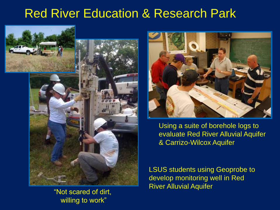
Red River Education & Research Park
“Not scared of dirt,
willing to work”
Using a suite of borehole logs to
evaluate Red River Alluvial Aquifer
& Carrizo-Wilcox Aquifer
LSUS students using Geoprobe to
develop monitoring well in Red
River Alluvial Aquifer

Institute Model
A Watershed Approach
Community
LSUSRed River Watershed
Management InstituteLocal, State &
UniversityFederal Agencies
A NEUTRAL ENTITY
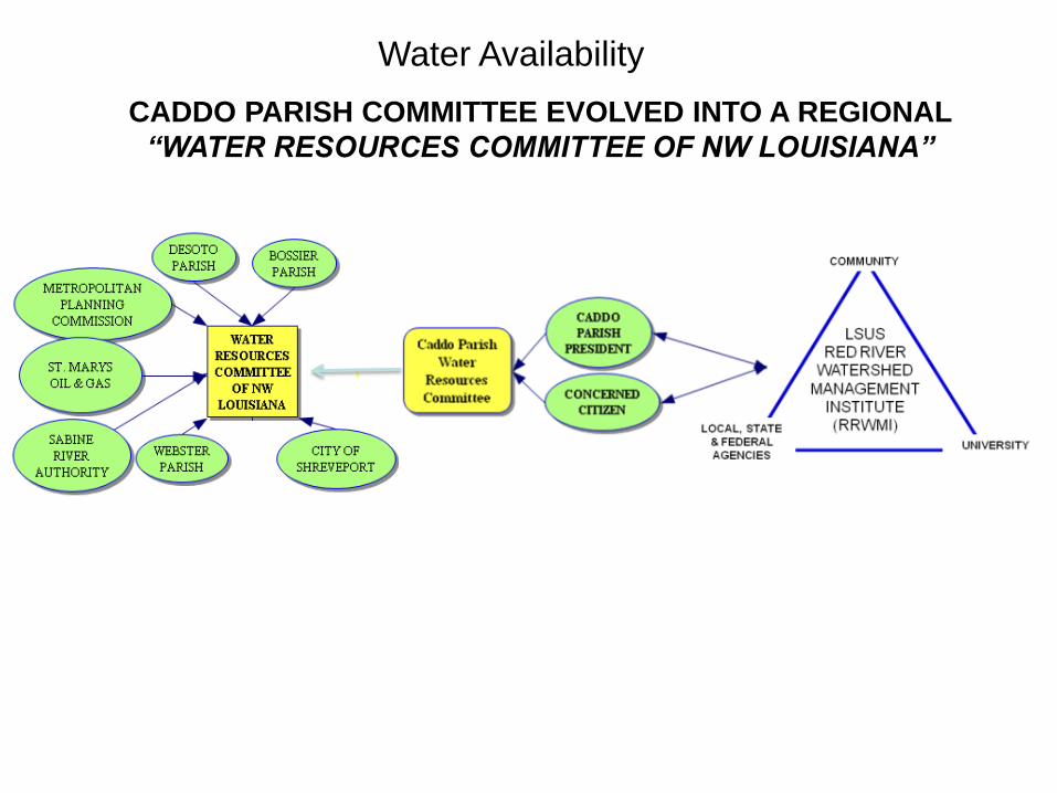
Water Availability
CADDO PARISH COMMITTEE EVOLVED INTO A REGIONAL
“WATER RESOURCES COMMITTEE OF NW LOUISIANA”

Water Resources Committee of Northwest Louisiana Watershed Based - Volunteer Committee
A Self-organizing Institution
– formed to protect water
quality & quantity
The Committee was formed by the Caddo Parish President, a concerned citizen
& Director of the RRWMI. As WRCNL evolved, more issues arose, & it became
more flexible & adapted to solve new challenges.

Wilcox Aquifer Potentiometric Surface

Wilcox Aquifer Recharge Potential
Red
River
Alluvial

Water Energy Working Group – Meeting at LSU ShreveportWG became more flexible & adapted to issues before or as they arose
Participants:
US Army Corps of Engineers Vicksburg (USACE)
Red River Waterway Commission, LAF&WS, LADEQ
Red River Watershed Management Institute (LSUS)
Red River Valley Assoc., Sabine River Authority,
Caddo Levee District, Bossier Levee District, La
DOTD, U.S. Fish & Wildlife Service, Chesapeake ,
Questar, EnCana, Petrohawk, Camterra , JW, Exco,
Shell, El Paso, Titanium Env. , Louisiana Oil & Gas
Assoc., Red River Pump, Impact Energy Services,
Water Resources Committee of Northwest Louisiana,
and International Paper Company, Mansfield
Early on & on a voluntary basis, most
Haynesville operators reduced their use of
groundwater
Co-chairs: Directors of Red River Watershed Management Institute & Red River Waterway Commission

LSUS
CLOSE COORDINATION BETWEEN WATER ENERGY
WORKING GROUP & OFFICE OF CONSERVATION
HAS BEEN CRITICAL FOR SUCCESS
LSUS
RRWMI

Tell me and I forget. Teach me and I remember. Involve me and I learn. Benjamin Franklin
South Camp
250
252
254
256
258
J A S O D J F M A M J J A S N J F A M J
Month
Wate
r L
evel
(ft)
20102008
Caddo Parish/LSUS GW Monitoring
Winter-Spring
Summer Summer
Water level appeared to be dropping rapidly in this area of heavy drilling & hydraulic fracturing
Lewis and Hanson, 2010

Caddo Ph/LSUS Wilcox Monitoring Well Project
2008 2011

Caddo Ph/LSUS Wilcox Monitoring Well Project
2008 2011

1400 GPM25-125 GPM
The Times (Shreveport) - This article is a good example of how
the press can inform and educate the public
Vickie Welborn, 2009

Solutions - Alternative surface water frac sources
EXCO has built a 9 mile pipeline in order to use treated
wastewater from International Paper Co. at Mansfield, La.
12 million gallons/dayThe Times, 2010

Solutions - Alternative surface water frac sources
EXCO’s 9-mile wastewater pipeline
IPCO


Baseline Water Quality Study of Aquifers in
Bossier, Caddo & De Soto Parishes
Louisiana Geological Survey Hydrologist/Geologist Doug Carlson (right) &
Marty Horn (middle) and Gary Hanson (left), LSU Shreveport
LSU & LSU Shreveport
working together. Up to
1000 domestic wells will
be sampled & analyzed

Frac Water Use – Haynesville Shale
Source Louisiana Department of Natural Resources (2010)After D. Carlson et al, 2011

Has Wilcox Aquifer Water Quality
Changed in the Past Three Years in
Response to Haynesville Hydraulic
Fracturing Activity?
Douglas Carlson & Marty Horn Louisiana Geological Survey
&
Thomas Van Biersel
Louisiana Department of Natural
Resources
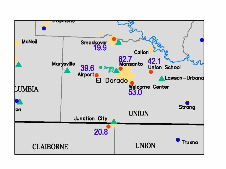
Location of this
study’s
first 450 wells

Location of Caddo Parish wells previously sampled
Location of current match set of wells ~75D. Carlson et al, 2011

June 1, 2010 to December 31, 2011
This study will create a base data set of water quality that
will include 950-1,050 samples analyzed for: Arsenic,
Boron, Bromide, Cadmium, Calcium, Chloride,
Chromium, Copper, Fluoride, Iron, Lead, Magnesium,
Manganese, Nickel, Nitrate, Nitrite, Potassium,
Phosphorus, Phosphate, Rubidium, Sulfate, Silicon,
Sodium, Strontium, TDS, and Zinc. The number of
values of chloride is approximately five times larger than
those in Rapp’s (1996) and even larger for other
parameters when compared to Rapp’s study which was
the largest study previously.
D. Carlson et al, 2011
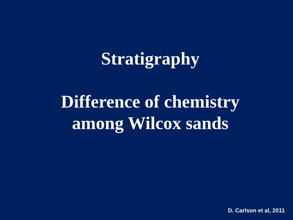
Stratigraphy
Difference of chemistry
among Wilcox sands
D. Carlson et al, 2011

D. Carlson et al, 2011

0.1
1
10
100
1000calc
ium
co
ncen
trati
on
(m
g/L
)
upper sandlower sand
0.1
1
10
100
mag
nesiu
m c
on
cen
trati
on
(m
g/L
)
upper sand lower sand
Calcium Magnesium
D. Carlson et al, 2011
0.001
0.01
0.1
1
10
nit
rate
co
ncen
trati
on
(m
g/L
)
upper sand
lower sand
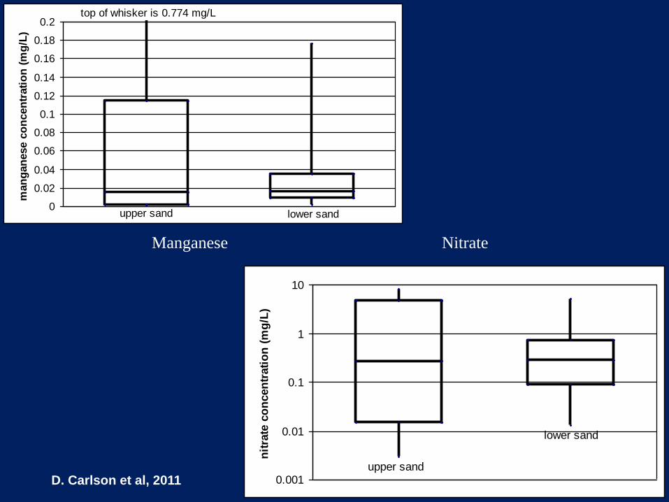
Manganese Nitrate
0
0.02
0.04
0.06
0.08
0.1
0.12
0.14
0.16
0.18
0.2m
an
gan
ese c
on
cen
trati
on
(m
g/L
)
upper sand lower sand
top of whisker is 0.774 mg/L
D. Carlson et al, 2011

1
10
100
1000so
diu
m c
on
cen
trati
on
(m
g/L
)
upper sand
lower sand
1
10
100
1000
ch
lori
de c
on
cen
trati
on
(m
g/L
)
upper sand
lower sand
Sodium Chloride
D. Carlson et al, 2011
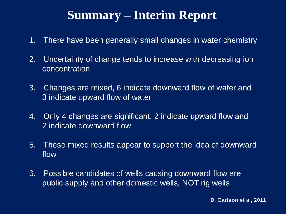
Summary – Interim Report
1. There have been generally small changes in water chemistry
2. Uncertainty of change tends to increase with decreasing ion
concentration
3. Changes are mixed, 6 indicate downward flow of water and
3 indicate upward flow of water
4. Only 4 changes are significant, 2 indicate upward flow and
2 indicate downward flow
5. These mixed results appear to support the idea of downward
flow
6. Possible candidates of wells causing downward flow are
public supply and other domestic wells, NOT rig wells
D. Carlson et al, 2011


Acknowledgements:
US EPA Region 6
City of Shreveport
AEP SWEPCO
LSU Shreveport & LSU System
Halliburton
Anderson Oil & Gas
uisiana Dept. of Natural Resource
ffice of Conservation
Lo s &
O
The Parishes of Caddo, DeSoto, Bossier &
Webster, Sabine River Authority & Red River
Waterway Commission & Metropolitan
Planning Commission
Members of the Water Energy Working Group
Louisiana Geological Survey
Union County Conservation Commission
Thank you!
How are Appropriate Water Sources for Hydraulic Fracturing Determined? Pre-development Conditions and Management of
Development Phase Water Usage Gary Hanson
Louisiana State University Shreveport
The statements made during the workshop do not represent the views or opinions of EPA. The claims made by participants have not been verified or endorsed by EPA.
Historically the determination of water sources for hydraulic fracturing has typically been left up to the oil or gas operator or their drilling contractor. Fresh water, although only one component of frac fluids in tight gas sand stimulation, was the source of choice and ease of access would determine whether surface or groundwater was used. Prior to multistage horizontal fracing of gas shales, use of ponds or nearby streams provided sufficient water to drill and frac a typical tight sand well in most areas of the country. However as the unconventional shale plays arrived on the scene using “slick-water” fracing technique and horizontally drilled wells that required multiple stages in order to effectively stimulate the reservoir, water demands increased dramatically. Groundwater, which had been only used periodically in the past, became the source of choice in many areas. Groundwater use for fracing increased in northwest Louisiana after the discovery of the massive Haynesville Shale. The public and rural water utilities saw this activity as a threat to “their” source of water, so from their perspective a water source (groundwater) that was previously considered an appropriate source for fracing, became an inappropriate source, as drilling and fracing continued. Prior to the onset of the Haynesville Shale gas boom in northwest Louisiana, two critical actions were taken by local government and a university. First, a voluntary water committee called the Water Resources Committee of Northwest Louisiana (WRCNL) was formed and second, one of the member parishes (counties) worked with the local LSU Shreveport University to set up a groundwater monitoring system. Both actions were taken prior to the Haynesville Shale discovery and because there was a perceived need that groundwater and surface water resources were in jeopardy. In some cases, as operators moved into the area multiple Wilcox aquifer water wells were drilled to not only supply water for drilling, but also for fracing. Rig supply wells are considered exempt wells (no notification to Office of Conservation prior to developing) in Louisiana, but groundwater wells used for fracing are considered industrial wells and there is a 60-day pre-drilling notice required. Groundwater use for fracing is not specifically deemed unlawful. As stated earlier, operators have always used groundwater as an appropriate water source for fracing, but with the onset of the Haynesville high volume (5 million gallons), multistage, horizontal well development program, other groundwater users (district water systems, domestic & agriculture) became concerned. For them, groundwater was not an appropriate water source for fracing. The Office of Conservation stepped in and advised that surface water or non-potable aquifer alternatives should be used as a source of water.

5
In 2001, the Red River Watershed Management Institute (Institute) was formed at LSU Shreveport and the Red River Education & Research Park (RRERP) was developed adjacent to the campus in the floodplain of the Red River. Faculty and students developed monitoring wells in the Red River Alluvial Aquifer (RRAA), an aquifer that had been studied historically by the USGS and other agencies. The RRAA is considered non-potable, but exhibits high deliverability due to its’ high porosity and high hydraulic conductivity and was a good candidate for alternative groundwater supply for fracing. The RRAA became an appropriate water source for fracing, and although there exists some competition from agriculture, it is deemed sustainable because it is sourced by the overlying Red River which has been impounded for navigation. In the early stages of the Haynesville development, a sub-committee of the WRCNL was formed and met at the Institute. Co-chaired by the Director of the Institute and the Executive Director of the Red River Waterway Commission, the Water Energy Working Group (WEWG) was comprised of federal and state regulators, operators and water transfer specialists. Although many Haynesville Shale operators had become convinced that they needed to reduce their dependence on the Wilcox Aquifer, appropriate alternatives could not be used without some kind of approval process. The WEWG worked to establish USACE permits for access to the Red River. Following formal opinions by the Louisiana Attorney General and legislation that would allow for the states “running” surface water, including the Red River, to be withdrawn legally, operators were given surface water alternative. Private ponds became an easy and appropriate source of surface water in areas remote from large waterbodies. If landowners filled the ponds using groundwater wells, however, the pond is not considered an appropriate water source for fracing by the state. Has the Wilcox aquifer been changed by Haynesville Shale drilling activity in northwest Louisiana? A study of up to 1000 domestic wells located in the areas of gas shale development, was undertaken by the Louisiana Geological Survey /LSU in cooperation with the watershed Institute at LSU Shreveport. Over one-third of the wells have been sampled and analyzed. About 75 domestic wells that were used in a previous study have been included (re-sampled and analyzed). No significant change in water quality has been observed at this point in the project. A project in nearby south Arkansas has been challenged to develop a recovery plan for Sparta Aquifer, historically the main source of water for pubic and industrial use. This successful project, which funded the construction of a 20-mile pipeline to a large river in order to supply water for industrial needs, allowed industry to stop drawing water from the aquifer and should be a model for the nation. A potential unconventional gas play is in the early stages of development in South Arkansas/North Louisiana and the Union County Water Conservation Board has the potential to supply about 20 million gallons of surface water as an appropriate water source for fracing.