use of sar data for rice assessment - university of...
TRANSCRIPT

Use of SAR data for Rice Assessment
N e e t u , S h i b e n d u S R a y a n d T e a mM a h a l a n o b i s N a t i o n a l C r o p F o r e c a s t C e n t r e ,
D e p a r t m e n t o f A g r i c u l t u r e , C o o p e r a t i o n & F a r m e r ’ s W e l f a r eM i n i s t r y o f A g r i c u l t u r e & F a r m e r ’ s W e l f a r e
G o v e r n m e n t o f I n d i aN e w D e l h i - 1 1 0 0 1 2 , I n d i aE m a i l : n e e t u . n c f c @ n i c . i n
• Introduction• Satellite Data• Methodology• What can be done from SAR data for Rice ?
• Acreage estimation• Biomass estimation• Area estimation during Flood/Drought• CCE Planning • Crop Map
• Validation• Future Scope
• Outlines
Operational Mapping/Monitoring of Agricultural Crops in South/Southeast Asian Countries-Research Needs and Priorities May 2 to 4, 2017

• Rice is the major food grain crop of India.• Rice is grown in multiple seasons in India i.e.
Kharif, Rabi and Summer Rice• India is the second largest producer of Rice in
world (https://apps.fas.usda.gov/).• Rice is grown in different environment in India.• Rice is grown with multiple cultural types in India.• Rice crop is highly dependent on Rainfall in India
(58.0 % Rice crop is irrigated) (Source:DAC&FW).
• Rice yield is highly varying in India. Mean Yield(Bihar ~1650 kg/ha and Punjab ~3900 kg/ha)(Source: DAC&FW)
• Introduction
Operational Mapping/Monitoring of Agricultural Crops in South/Southeast Asian Countries-Research Needs and Priorities May 2 to 4, 2017

• Satellite Data Satellit
e Sens
orResolution Swath
Spectral Bands used
Sets of data
required at a time
Time Period
Radarsat-2
ScanSARNarrow B
25m 300 km C band SAR HH Polarization data
Multi-date KharifSeason (May to July) for Punjab, Haryana
and (June to
September) for rest of the Study
States,(October to January) for Tamil Nadu
RISAT-1 MRS mode
18m 115km C Band SAR HH Polarization data
Multi-date
Sentinel -1 A
SAR 20m 250 km C Band VV
Polarization SAR
data
Multi-date Rabi Season
(January to March) for
Rabi Paddy
CropNo. of Study States
State to Nation
State to Nation
(% Area Contributio
n)
(% Production Contributio
n)
KharifRice 14 90 91
Radarsat-2 and RISAT-1Swath Coverage's over India
Operational Mapping/Monitoring of Agricultural Crops in South/Southeast Asian Countries-Research Needs and Priorities May 2 to 4, 2017

• Methodology
Operational Mapping/Monitoring of Agricultural Crops in South/Southeast Asian Countries-Research Needs and Priorities May 2 to 4, 2017

Operational Mapping/Monitoring of Agricultural Crops in South/Southeast Asian Countries-Research Needs and Priorities May 2 to 4, 2017
• Acreage Estimation
• What can be done from SAR data for Rice ?


Operational Mapping/Monitoring of Agricultural Crops in South/Southeast Asian Countries-Research Needs and Priorities May 2 to 4, 2017
• Acreage Estimation
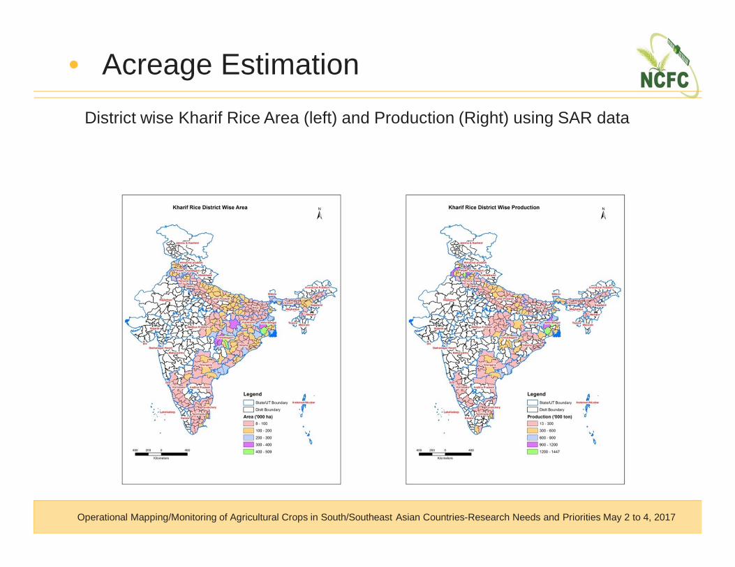
• Acreage EstimationDistrict wise Kharif Rice Area (left) and Production (Right) using SAR data
Operational Mapping/Monitoring of Agricultural Crops in South/Southeast Asian Countries-Research Needs and Priorities May 2 to 4, 2017

• Acreage EstimationState wise Rice Area and Production using SAR
data for Kharif Rice in India from 2012-13 to 2016- 17
Operational Mapping/Monitoring of Agricultural Crops in South/Southeast Asian Countries-Research Needs and Priorities May 2 to 4, 2017

• Biomass Estimation
Source: SAC, ISRO
Mean TP vs Frequency and Normalized age vs Biomass for Bihar 2015-16
Operational Mapping/Monitoring of Agricultural Crops in South/Southeast Asian Countries-Research Needs and Priorities May 2 to 4, 2017

• Area estimation during Flood

• Area estimation during FloodRice-Flooded Area Assessment, post-Phailin Cyclone in Odisha State,
October, 2013
Operational Mapping/Monitoring of Agricultural Crops in South/Southeast Asian Countries-Research Needs and Priorities May 2 to 4, 2017
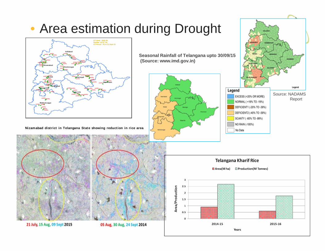
Nizamabad district in Telangana State showing reduction in rice area
GT Used - 2015-16Number of GT: 93GT Period : 03 to 21-Sept-15
• Area estimation during Drought
Source: NADAMSReport
Seasonal Rainfall of Telangana upto 30/09/15 (Source: www.imd.gov.in)

• Generation of crop specific mapusing SAR data and ground truth
• NDVI computation for specificcropped area.
• Integration with other parameters(remote sensing, soil, weather), ifavailable
• Classification into 4-6 classes,based on the variability existing
• Select CCE points randomly withineach stratum
• Overlay the village boundary on theCCE locations
• Prepare a list of CCE points, alongwith the geographical coordinates,village (and block and districtnames)
• CCE Planning
Operational Mapping/Monitoring of Agricultural Crops in South/Southeast Asian Countries-Research Needs and Priorities May 2 to 4, 2017
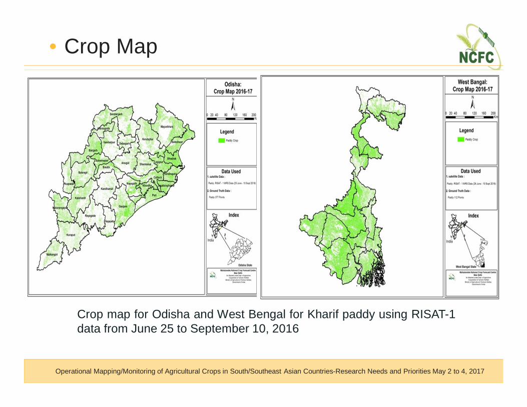
• Crop Map
Crop map for Odisha and West Bengal for Kharif paddy using RISAT-1data from June 25 to September 10, 2016
Operational Mapping/Monitoring of Agricultural Crops in South/Southeast Asian Countries-Research Needs and Priorities May 2 to 4, 2017
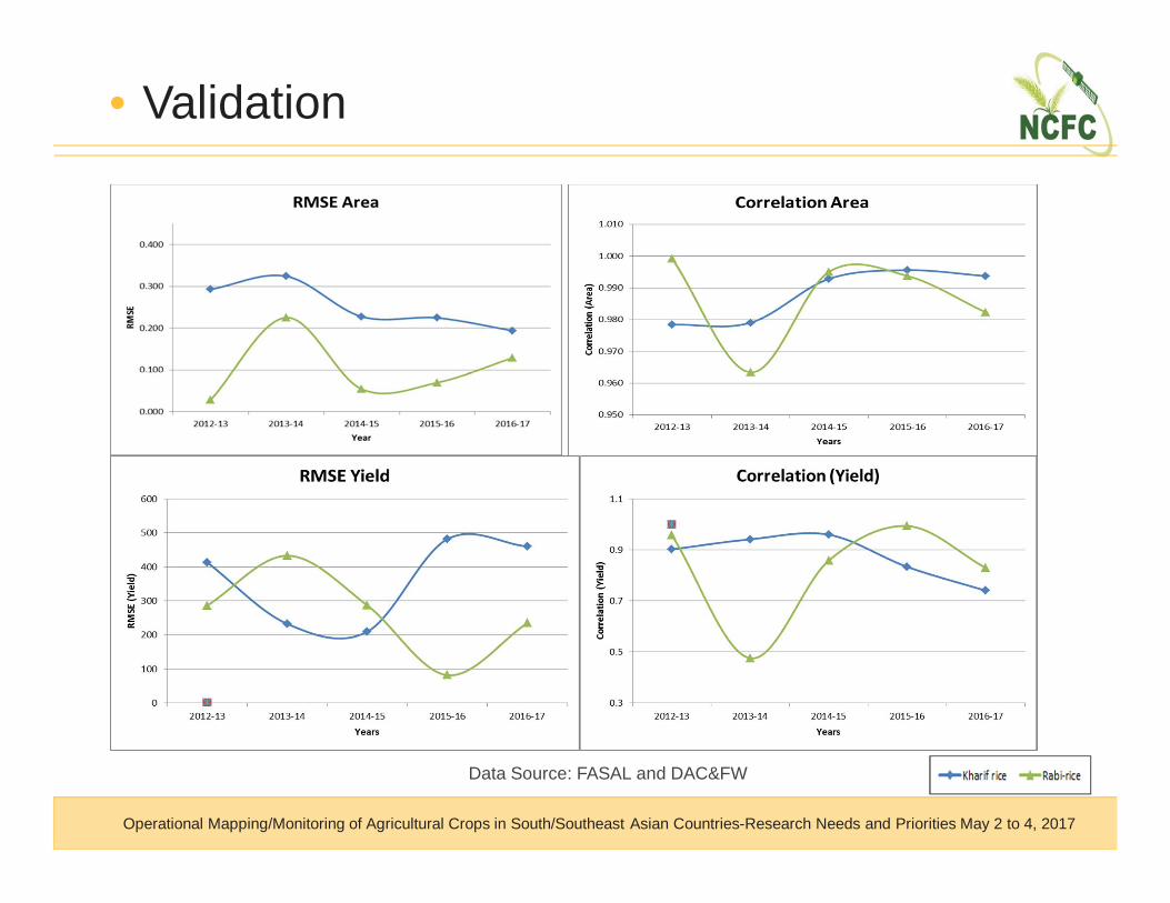
• Validation
Operational Mapping/Monitoring of Agricultural Crops in South/Southeast Asian Countries-Research Needs and Priorities May 2 to 4, 2017
Data Source: FASAL and DAC&FW
• Methodology needs to be developed for more crops (Cotton ,
Maize etc.) grown in Kharif Season using SAR data.
• Farm level/ Village level crop area/loss assessment using High
Resolution SAR (Sentinel, 10 m in every 5 days) data.
• Improved data frequency and resolution will definitely improve
the biomass estimation accuracy.
• Further research needed for crop parameter retrieval (biomass,
LAI, Phenology, Yield) from SAR.
• Future Scope
Operational Mapping/Monitoring of Agricultural Crops in South/Southeast Asian Countries-Research Needs and Priorities May 2 to 4, 2017

Team• Dr. Shalini Saxena• Mr. Sunil Kumar Dubey• Mr. Kanwar Vivek Singh • Mr Akhilesh Porwal • Mr Rajat Saxena• Mr Santosh Kumar• Dr. Varunika Jain • Mr Ashutosh Kumar Gavli
Organizations• Indian Space Research Organization• Department of Agriculture, Cooperation & Farmers’ Welfare• India Meteorological Department• Institute of Economic Growth• State Agriculture Departments• State Remote Sensing Centres• Team Members from MNCFC
• Acknowledgment
THANK YOU
This work has been done under FASAL project of DAC&FW.