use of gps/gnss for future nasa missions - gps.gov
TRANSCRIPT

1
James J. Miller, Sr. GPS Technologist
Space Communications & Navigation
Space Operations Mission Directorate
GNSS Workshop:
Asia-Pacific Regional
Space Agency Forum
January 25-26, 2010
Use of GPS/GNSS for Future NASA Missions

2
Presentation Overview
SCaN Organization & Role at NASA
GPS as a PNT Enabler for Space Ops & Science
Current GPS Activities and Mission Areas
Research and Future GNSS Mission Areas

3•3
NASA Organization Chart
Space Communication and Navigation (SCaN) Office

4•4
Space Communications & Navigation (SCaN) Organization
PNT Policy

5
What does the Global Positioning System (GPS) do for NASA?
• Positioning, Navigation, & Timing (PNT) are the GPS “services” that enable:
1. Real-time On-Board Autonomous Navigation: Use of GPS as a source for position and time allows NASA to maximize the “autonomy” of spacecraft and reduces the burden and costs of network operations. It also enables new precise methods of spaceflight such as formation flying.
2. Attitude Determination: Use of GPS enables some missions to meet their attitude determination requirements, such as the International Space Station (ISS).
3. Earth Science: GPS used as a remote sensing tool supports atmospheric and ionospheric sciences, geodesy, and geodynamics -- from monitoring sea level heights and climate change to understanding the gravity field.

6
GPS as a PNT Enabler: Emerging Trends • Trend analyses based on worldwide launch logs, launch manifests, and
missions under R&D indicate that: – Approximately 60% of future worldwide space missions to operate in Low
Earth Orbit (LEO), which is inside the GPS Terrestrial Service Volume– And additional 35% of missions to operate beyond LEO and up to
Geosynchronous Orbit (GSO) altitude, which is inside the GPS Space Service Volume
• In summary, approximately 95% of projected worldwide space missions over the next 20 years will operate within the GPS service envelope
• GPS Application Areas in Space – Navigation, Attitude Determination, Science, etc.
International Space Station(Application: Attitude Determination)
Space Shuttle(Application: Navigation)
Earth Observing System (Application: Science)

7
Current GPS Activities and Mission Areas:Space Navigation with GPS
•GPS Terrestrial Service Volume–Up to 3,000 km altitude–Most current applications
•GPS Space Service Volume (SSV)–3,000 km altitude to GEO–Many emerging space users–Geostationary Satellites–High Earth Orbits (Apogee above GEO altitude)
•SSV users share unique GPS signal challenges–Number of satellite views more limited
–GPS first side lobe signals are important
•Performance requirements established via three parameters–Pseudorange accuracy–Received power–Signal availability
8
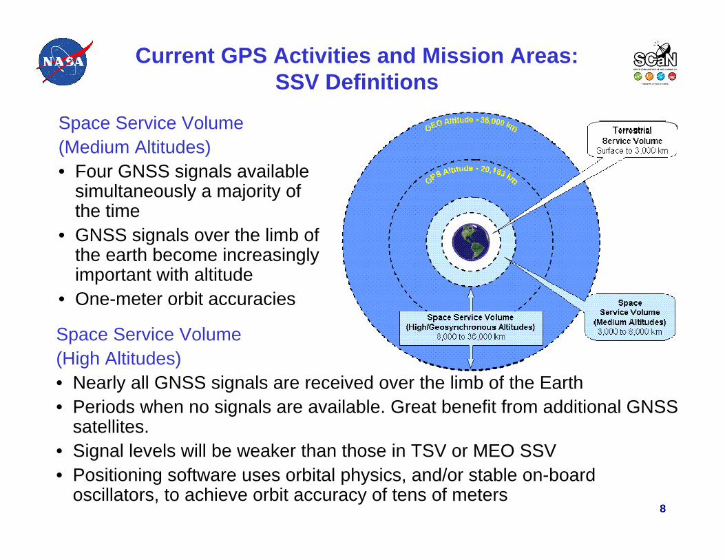
Current GPS Activities and Mission Areas:SSV Definitions
Space Service Volume (Medium Altitudes)• Four GNSS signals available
simultaneously a majority of the time
• GNSS signals over the limb of the earth become increasingly important with altitude
• One-meter orbit accuracies
Space Service Volume (High Altitudes)• Nearly all GNSS signals are received over the limb of the Earth• Periods when no signals are available. Great benefit from additional GNSS
satellites.• Signal levels will be weaker than those in TSV or MEO SSV• Positioning software uses orbital physics, and/or stable on-board
oscillators, to achieve orbit accuracy of tens of meters

9
Current GPS Activities and Mission Areas:Tracking of Launch Vehicles
• Space-based navigation, GPS, and Space Based Range Safety technologies are key components of the next generation launch and test range architecture
• Provides a more cost-effective launch and range safety infrastructure while augmenting range flexibility, safety, and operability
• Memorandum signed in November 2006 for future GPS Metric Tracking (GPS MT) for all DoD, NASA, and U.S. commercial vehicles launched at the Eastern andWestern ranges
•GPS-TDRSS Space-Based Range

10
Current GPS Activities and Mission Areas:Human Space Flight
Space Shuttle Program• Specialized GPS receivers designed to accept
Inertial Navigation System (INS) aiding • One GPS receiver (retaining TACAN1 as backup)
installed on Discovery and Atlantis• Three GPS receivers on Endeavour (TACAN
removed)• GPS taken to navigation for the first time on STS-
115 / Atlantis during re-entry and landing• GPS/INS – only navigation used on STS-118 /
Endeavour for re-entry and landing
STS-115: 9-21 Sept. 2006
International Space Station (ISS)• Combined GPS + INS receiver tested on
shuttle flights April 2002 (STS-110 / Atlantis)
• Four GPS antennas on the ISS truss assembly
• Used for attitude determination
STS-118: 8-21 Aug. 2007
ISS as viewed from STS-118
1Tactical Air Navigation System
Project Constellation• A combination of GPS receivers and INS will be used
on Orion, which is scheduled to replace the Space Shuttle
Artist concepts of Orion approaching the ISS and Orion landing

11
Current GPS Activities and Mission Areas:Earth Science Applications
IONOSPHEREIONOSPHEREOCEANSOCEANS SOLID EARTHSOLID EARTH
ATMOSPHEREATMOSPHERE
Significantwave heightSignificant
wave height
Ocean geoid andglobal circulationOcean geoid andglobal circulation
Surface windsand sea state
Surface windsand sea state
Short-term eddyscale circulationShort-term eddyscale circulation
OCEANSOCEANS
Significantwave heightSignificant
wave height
Ocean geoid andglobal circulationOcean geoid andglobal circulation
Surface windsand sea state
Surface windsand sea state
Short-term eddyscale circulationShort-term eddyscale circulation
OCEANSOCEANS
High resolution 3Dionospheric imagingHigh resolution 3D
ionospheric imaging
Ionospheric struc-ture & dynamics
Ionospheric struc-ture & dynamics
Iono/thermo/atmo-spheric interactionsIono/thermo/atmo-
spheric interactions
Onset, evolution& prediction ofSpace storms
Onset, evolution& prediction ofSpace storms
TIDs and globalenergy transportTIDs and globalenergy transport
Precise ion cal forOD, SAR, altimetryPrecise ion cal forOD, SAR, altimetry
IONOSPHEREIONOSPHERE
Climate change &weather modelingClimate change &weather modeling
Global profiles of atmosdensity, pressure, temp,and geopotential height
Global profiles of atmosdensity, pressure, temp,and geopotential height
Structure, evolutionof the tropopause
Structure, evolutionof the tropopause
Atmospheric winds,waves & turbulenceAtmospheric winds,waves & turbulence
Tropospheric watervapor distribution
Tropospheric watervapor distribution
Structure & evolutionof surface/atmosphere
boundary layer
Structure & evolutionof surface/atmosphere
boundary layer
ATMOSPHEREATMOSPHERE
High resolution 3Dionospheric imagingHigh resolution 3D
ionospheric imaging
Ionospheric struc-ture & dynamics
Ionospheric struc-ture & dynamics
Iono/thermo/atmo-spheric interactionsIono/thermo/atmo-
spheric interactions
Onset, evolution& prediction ofSpace storms
Onset, evolution& prediction ofSpace storms
TIDs and globalenergy transportTIDs and globalenergy transport
Precise ion cal forOD, SAR, altimetryPrecise ion cal forOD, SAR, altimetry
IONOSPHEREIONOSPHERE
Climate change &weather modelingClimate change &weather modeling
Global profiles of atmosdensity, pressure, temp,and geopotential height
Global profiles of atmosdensity, pressure, temp,and geopotential height
Structure, evolutionof the tropopause
Structure, evolutionof the tropopause
Atmospheric winds,waves & turbulenceAtmospheric winds,waves & turbulence
Tropospheric watervapor distribution
Tropospheric watervapor distribution
Structure & evolutionof surface/atmosphere
boundary layer
Structure & evolutionof surface/atmosphere
boundary layer
ATMOSPHEREATMOSPHERE
Earth rotationPolar motion
Earth rotationPolar motion
Deformation of thecrust & lithosphereDeformation of thecrust & lithosphere
Location & motionof the geocenter
Location & motionof the geocenter
Gross massdistributionGross massdistribution
Structure, evolution of the deep interior
Structure, evolution of the deep interior
Shape of the earthShape of the earth
SOLID EARTHSOLID EARTH
Earth rotationPolar motion
Earth rotationPolar motion
Deformation of thecrust & lithosphereDeformation of thecrust & lithosphere
Location & motionof the geocenter
Location & motionof the geocenter
Gross massdistributionGross massdistribution
Structure, evolution of the deep interior
Structure, evolution of the deep interior
Shape of the earthShape of the earth
SOLID EARTHSOLID EARTH
Southern California Integrated GPS Network•Operated and maintained by NASA, SOPAC (Scripps Orbit And Permanent Array Center) , and USGS (U.S. Geological Survey)
Gravity Field Measurements(GRACE Mission)
Ionospheric Remote Sensing using GPS Occultation
Ocean Topography
(2004 Tsunami with GPS offsets)

12
US agencies that contribute to the IGS include: • National Aeronautics and Space Administration (NASA), • National Geospatial-Intelligence Agency (NGA), • National Oceanic and Atmospheric Administration (NOAA)• National Geodetic Survey (NGS), • Naval Research Laboratory (NRL), • National Science Foundation (NSF), • US Naval Observatory (USNO), and • US Geological Survey(USGS),
… and numerous universities & research organizations.
•Graph courtesy Analysis Coordinator
•G. Gendt, GFZ Potsdam
GPS Applications in IGS Projects & Working GroupsIGS Reference FrameSupporting AREF - African Reference FramesPrecise Time & Frequency TransferGLONASS Pilot Service Project, now routine within IGS processesLow Earth Orbiters ProjectIonosphere WGAtmosphere WGSea Level - TIGA ProjectReal-Time ProjectData Center WGGNSS WG
•GNSS: Global Navigation Satellite System
The IGS is a voluntary federation of more than 200 worldwide agencies in more than 90 countries that pool resources and permanent GPS station data to generate precise GPS products.
Over 350 permanent tracking stations operated by more than 100 worldwide agencies comprise the IGS network. Currently the IGS supports two GNSS: GPS
and the Russian GLONASS.
IGS products are formed by combining independent results from each of several Analysis Centers. Improvements in signals and computations have brought the centers’consistency in the Final GPS satellite orbit calculation to ~ 2cm http://igscb.jpl.nasa.gov
NASA funds the coordinating center the IGS Central Bureau
Current GPS Activities and Mission Areas: International GNSS Service (IGS)

13
Current GPS Activities and Mission Areas: Global Differential GPS System (GDGPS)
• Global, seamless, GPS augmentation system developed and operated by NASA's Jet Propulsion Laboratory– Supports real-time positioning, timing, and environmental monitoring for agency
science missions. Provides advanced real-time performance monitoring– Provides timely products for GPS situational assessment, natural hazard
monitoring, emergency geolocation, and other applications.– Operational since 2000, has more than 100 dual-frequency GPS reference
stations(100+ tracking
sites)
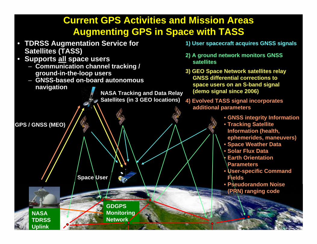
Current GPS Activities and Mission AreasAugmenting GPS in Space with TASS
• TDRSS Augmentation Service for Satellites (TASS)
• Supports all space users– Communication channel tracking /
ground-in-the-loop users– GNSS-based on-board autonomous
navigation
3) GEO Space Network satellites relay GNSS differential corrections to space users on an S-band signal (demo signal since 2006)
1) User spacecraft acquires GNSS signals
2) A ground network monitors GNSS satellites
• GNSS integrity Information• Tracking Satellite
Information (health, ephemerides, maneuvers)
• Space Weather Data• Solar Flux Data • Earth Orientation
Parameters • User-specific Command
Fields• Pseudorandom Noise
(PRN) ranging code
4) Evolved TASS signal incorporates additional parameters
NASA Tracking and Data Relay Satellites (in 3 GEO locations)
GPS / GNSS (MEO)
Space User
GDGPS Monitoring Network
NASA TDRSS Uplink
15
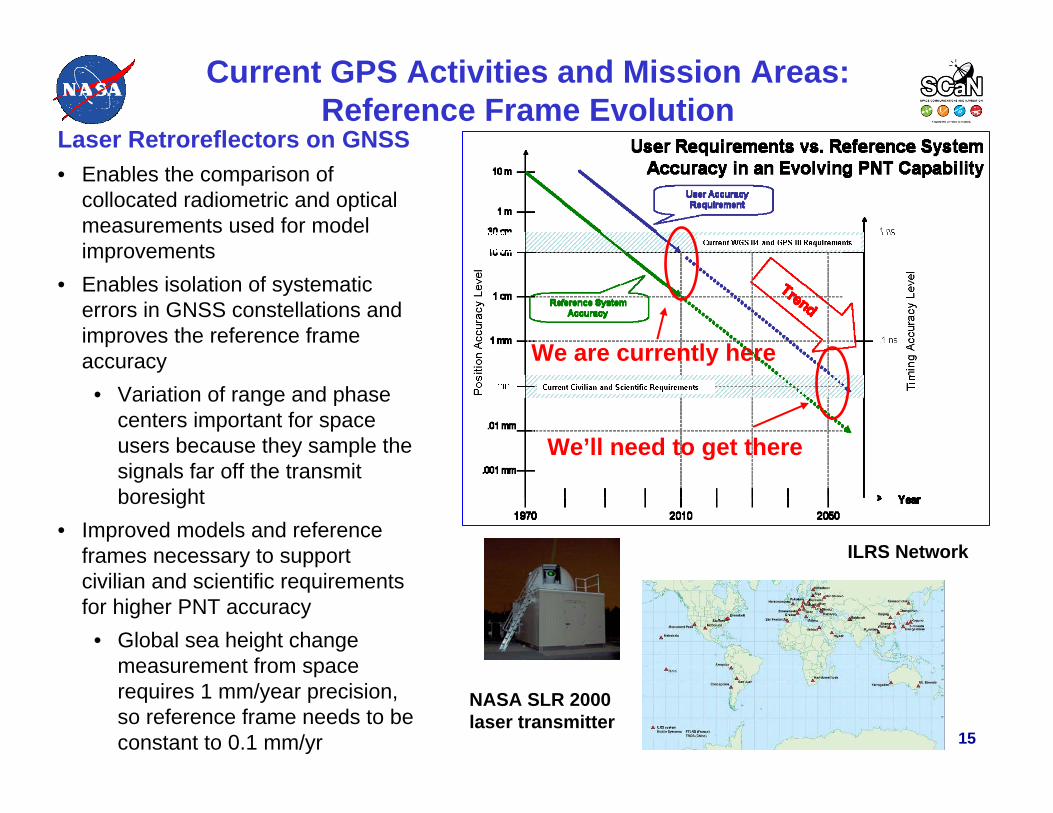
Current GPS Activities and Mission Areas: Reference Frame Evolution
Laser Retroreflectors on GNSS• Enables the comparison of
collocated radiometric and optical measurements used for model improvements
• Enables isolation of systematic errors in GNSS constellations and improves the reference frame accuracy
• Variation of range and phase centers important for space users because they sample the signals far off the transmit boresight
• Improved models and reference frames necessary to support civilian and scientific requirements for higher PNT accuracy
• Global sea height change measurement from space requires 1 mm/year precision, so reference frame needs to be constant to 0.1 mm/yr
We are currently here
We’ll need to get there
ILRS Network
NASA SLR 2000 laser transmitter

16
Current GPS Activities and Mission AreasDistress Alerting Satellite System (DASS)
•Uplink antenna
•Downlink antenna
•Repeater
•SARSAT Mission Need:• More than 800,000 emergency beacons in use worldwide by the civil community – most mandated by regulatory bodies
• Expect to have more than 100,000 emergency beacons in use by U.S. military services
• Since the first launch in 1982, current system has contributed to saving over 20,000 lives worldwide
•Status:• SARSAT system to be discontinued as SAR payload implemented on Galileo
• NASA and Air Force developed options for U.S. SAR system
• Successful NASA Proof-of-Concept DASS on GPS IIR(M) and IIF satellites
• GPS III transition underway

17
Mission GNSS Application Orbit Receiver Signals Launch
Glory GPS Orbit LEO BlackJack L1 2010
LandSat GPS Orbit LEO GD Viceroy L1 2012
COSMIC IIAGPS, GLONASS, Galileo
Occultation LEO TriG (potential) L1, L2, L5, Galileo, GLONASS 2013
Jason IIIGPS, GLONASS, Galileo
Oceanography LEO TriG (potential) L1, L2, L5, Galileo, GLONASS 2013
GPM GPS Orbit, time GEO Navigator L1 C/A 2013
COSMIC IIBGPS, GLONASS, Galileo
Occultation LEO TriG (potential) L1, L2, L5, Galileo, GLONASS 2014
Orion Crew Vehicle GPS Orbit, trajectory
LEO, MEO, GEO,trans-lunar
2 HI (Navigator) L1 C/A 2014
MMS GPS Rel. range, orbit, time up to 30 Re Navigator L1 C/A 2014
CLARREOGPS, GLONASS, Galileo
Occultation LEO TriG (potential) L1, L2, L5, Galileo, GLONASS 2015
GOES-R GPS Orbit GEO Navigator L1 C/A 2015
DESDynl GPS Precise orbit LEO TriG (potential) L1, L2, L5, Galileo, GLONASS 2016
Research and Future GNSS Mission Areas:Upcoming Missions
18
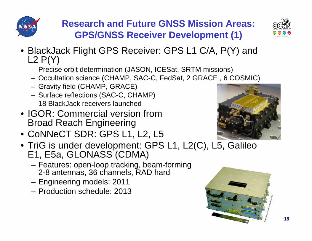
• BlackJack Flight GPS Receiver: GPS L1 C/A, P(Y) and L2 P(Y)– Precise orbit determination (JASON, ICESat, SRTM missions)– Occultation science (CHAMP, SAC-C, FedSat, 2 GRACE , 6 COSMIC)– Gravity field (CHAMP, GRACE)– Surface reflections (SAC-C, CHAMP)– 18 BlackJack receivers launched
• IGOR: Commercial version fromBroad Reach Engineering
• CoNNeCT SDR: GPS L1, L2, L5• TriG is under development: GPS L1, L2(C), L5, Galileo
E1, E5a, GLONASS (CDMA)– Features: open-loop tracking, beam-forming
2-8 antennas, 36 channels, RAD hard– Engineering models: 2011– Production schedule: 2013
Research and Future GNSS Mission Areas:GPS/GNSS Receiver Development (1)
19
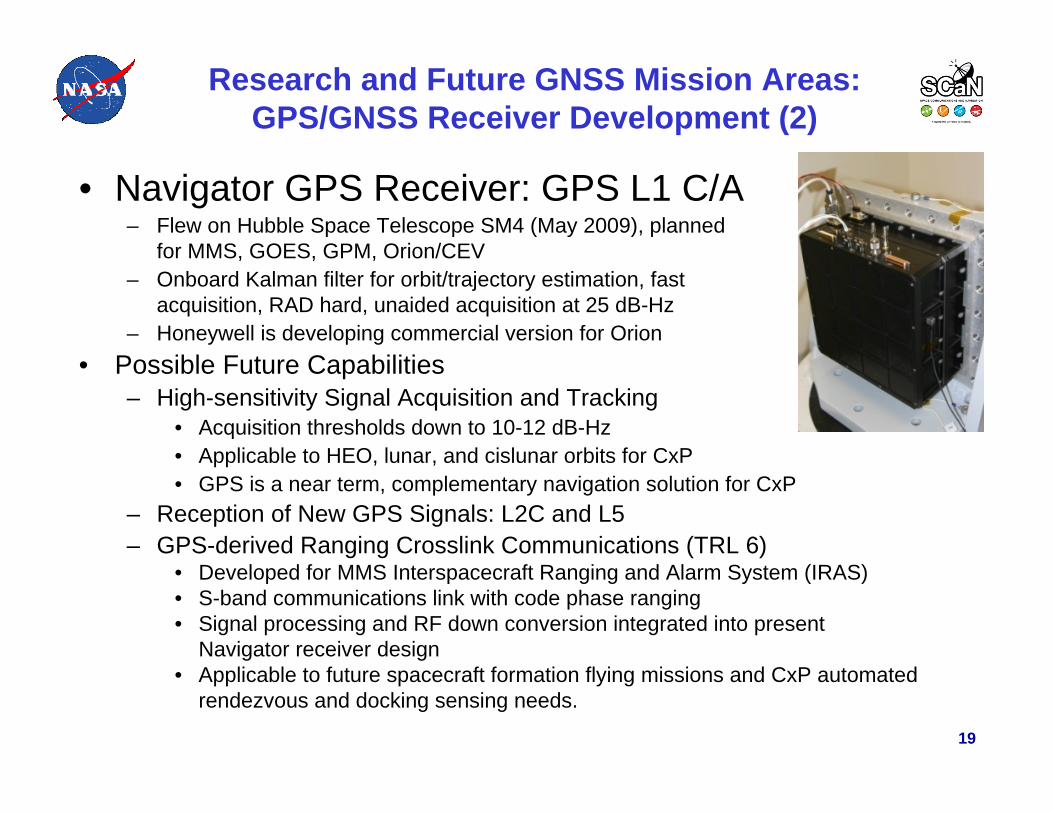
• Navigator GPS Receiver: GPS L1 C/A– Flew on Hubble Space Telescope SM4 (May 2009), planned
for MMS, GOES, GPM, Orion/CEV– Onboard Kalman filter for orbit/trajectory estimation, fast
acquisition, RAD hard, unaided acquisition at 25 dB-Hz– Honeywell is developing commercial version for Orion
• Possible Future Capabilities– High-sensitivity Signal Acquisition and Tracking
• Acquisition thresholds down to 10-12 dB-Hz• Applicable to HEO, lunar, and cislunar orbits for CxP• GPS is a near term, complementary navigation solution for CxP
– Reception of New GPS Signals: L2C and L5– GPS-derived Ranging Crosslink Communications (TRL 6)
• Developed for MMS Interspacecraft Ranging and Alarm System (IRAS)• S-band communications link with code phase ranging• Signal processing and RF down conversion integrated into present
Navigator receiver design• Applicable to future spacecraft formation flying missions and CxP automated
rendezvous and docking sensing needs.
Research and Future GNSS Mission Areas:GPS/GNSS Receiver Development (2)
20
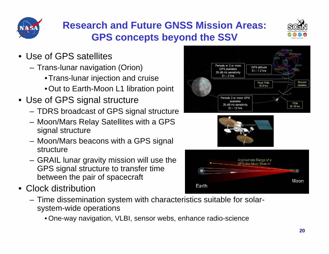
• Use of GPS satellites– Trans-lunar navigation (Orion)
•Trans-lunar injection and cruise•Out to Earth-Moon L1 libration point
• Use of GPS signal structure– TDRS broadcast of GPS signal structure– Moon/Mars Relay Satellites with a GPS
signal structure– Moon/Mars beacons with a GPS signal
structure– GRAIL lunar gravity mission will use the
GPS signal structure to transfer timebetween the pair of spacecraft
• Clock distribution– Time dissemination system with characteristics suitable for solar-
system-wide operations• One-way navigation, VLBI, sensor webs, enhance radio-science
Research and Future GNSS Mission Areas:GPS concepts beyond the SSV

21
Questions?

22
Contact Information
James J. Miller, Sr. GPS TechnologistSpace Communications and NavigationSpace Operations Mission DirectorateNational Aeronautics and Space Administration
(202) [email protected]