usace erdc’s coastal storm modeling · pdf file · 2015-11-17usace...
TRANSCRIPT

USACE ERDC’s Coastal Storm Modeling System
Chris Massey, Jay Ratcliff, and Mary Cialone USACE-ERDC-Coastal & Hydraulics Lab Vicksburg, MS
Innovative solutions for a safer, better world BUILDING STRONG®
Chris Massey USACE-ERDC-CHL
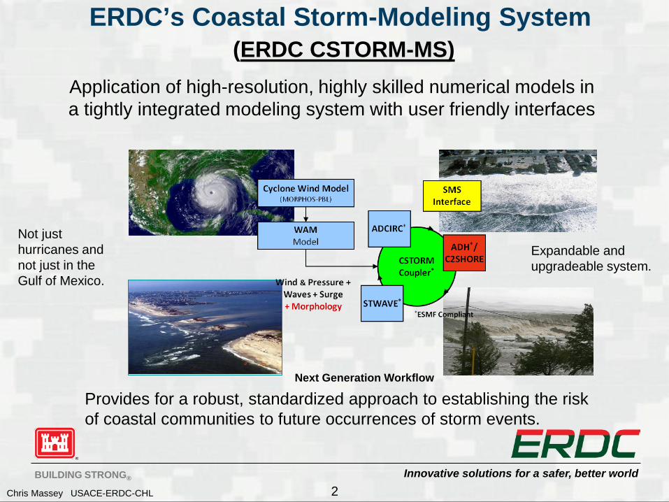
ERDC’s Coastal Storm-Modeling System (ERDC CSTORM-MS)
2
Next Generation Workflow
Not just hurricanes and not just in the Gulf of Mexico.
Expandable and upgradeable system.
Application of high-resolution, highly skilled numerical models in a tightly integrated modeling system with user friendly interfaces
Provides for a robust, standardized approach to establishing the risk of coastal communities to future occurrences of storm events.

Innovative solutions for a safer, better world BUILDING STRONG®
Chris Massey USACE-ERDC-CHL
An Example Storm Surge and Wave Problem
3
Morganza to the Gulf of
Mexico Feasibility Study

Innovative solutions for a safer, better world BUILDING STRONG®
Chris Massey USACE-ERDC-CHL
Storm 314 Without Project With Project
Sea
Leve
l Ris
e 0.
35 m
Exi
stin
g W
ater
Lev
el
Sea
Leve
l Ris
e 0.
35 m
Exi
stin
g W
ater
Lev
el
4

Innovative solutions for a safer, better world BUILDING STRONG®
Chris Massey USACE-ERDC-CHL
SMS Graphical User Interface
• New GUI for Project Overview
• New GUI for MORPHOS PBL Cyclone Model
• New GUI for CSTORM Coupled Models
• Updated GUI for AdH
• New GUI for WAM Wave Model
•Updated GUI for STWAVE
• Updated GUI for ADCIRC
Through the SMS GUI’s users can setup and execute models as well as visualize model results.
5

Innovative solutions for a safer, better world BUILDING STRONG®
Chris Massey USACE-ERDC-CHL
Incorporating Land Use Types
6
Land Cover Model Attributes

Innovative solutions for a safer, better world BUILDING STRONG®
Chris Massey USACE-ERDC-CHL
CSTORM Coupling Framework (Example Waves + Circulation)
• One unstructured finite element circulation mesh – A single instance of ADCIRC/ADH
• One or more structured wave grids – Multiple instances of STWAVE
• Half-Plane • Full-Plane
STWAVE Snaps
CIRC Timeline
CIRC WAVE
,x yτ τ
, ,u vζ
Information to Exchange
For consistency use the same winds and bathymetry (can be passed also)
Need to be able to synchronize both time and spatial frames of reference.
7

Innovative solutions for a safer, better world BUILDING STRONG®
Chris Massey USACE-ERDC-CHL
Circulation Wave Coupling
8
Schematic for CSTORM-MS Spiral 1 -- ADCIRC+STWAVE
• Controller – 1 cpu • Coupler – 1 cpu (1 coupler/STWAVE) • CIRC/STWAVE share cpu’s
• Model coupling between ADCIRC/ADH and STWAVE is performed using CSTORM-MS Couplers written in FORTRAN and MPI.
• Models run sequentially, so Circ. and Wave models share processors
• One benefit of using the ESMF coupling standards is that the individual codes stay virtually autonomous.
• Specification of how the two models are to interact is done with a simple control file (mf_config.in).
• If more than one STWAVE grid is involved, fine detail control over any overlapping regions can be specified by using a (merge_file).
Expandable !
PC and HPC applications!

Innovative solutions for a safer, better world BUILDING STRONG®
Chris Massey USACE-ERDC-CHL
Hurricane Sandy Response Advisory 31 Time Series Water Elevation (ft MSL)
Times are UTC
•Used two ADCIRC meshes • EC2001FIMP Grid • FEMA Region 2 Grid
• Used tidal forcing • Used an imbedded asymmetric vortex Holland wind/pressure model with inputs derived from the NHC forecast using the ASGS • Now able to use winds/pressure from NOAA’s GFDL models
9

Innovative solutions for a safer, better world BUILDING STRONG®
Chris Massey USACE-ERDC-CHL
Total Water Depth (feet MSL)
Total Water Depth (ft MSL)
Results from ADCIRC, using the FEMA Region 2 Mesh and NWS Forecast Winds from Advisory 31 of Hurricane Sandy.
Location of Tunnel Entrance/Exit
Location of Tunnel Entrance/Exit

Innovative solutions for a safer, better world BUILDING STRONG®
Chris Massey USACE-ERDC-CHL
North Atlantic Coast Comprehensive Study
Sandy Impact Areas This study computed the joint probability of Hurricane Sandy and historical coastal storm forcing parameters for the east coast region from Maine to Virginia as a primary requirement for project performance evaluation. The primary focus was on storm winds, waves and water levels along the coast for both tropical and extra-tropical storm events.

Innovative solutions for a safer, better world BUILDING STRONG®
Chris Massey USACE-ERDC-CHL
NACCS Grids and Save Points
12
ADCIRC
~ 3.1 million nodes Resolution from 10 m to 100 km
ADCIRC Mesh Resolution
Save Points Project Specific

Innovative solutions for a safer, better world BUILDING STRONG®
Chris Massey USACE-ERDC-CHL
Wave Grids
13
STWAVE WAM*
10 STWAVE Domains
resolution from 100m to 200m
~7.8 million cells
Innovative solutions for a safer, better world BUILDING STRONG®
Chris Massey USACE-ERDC-CHL
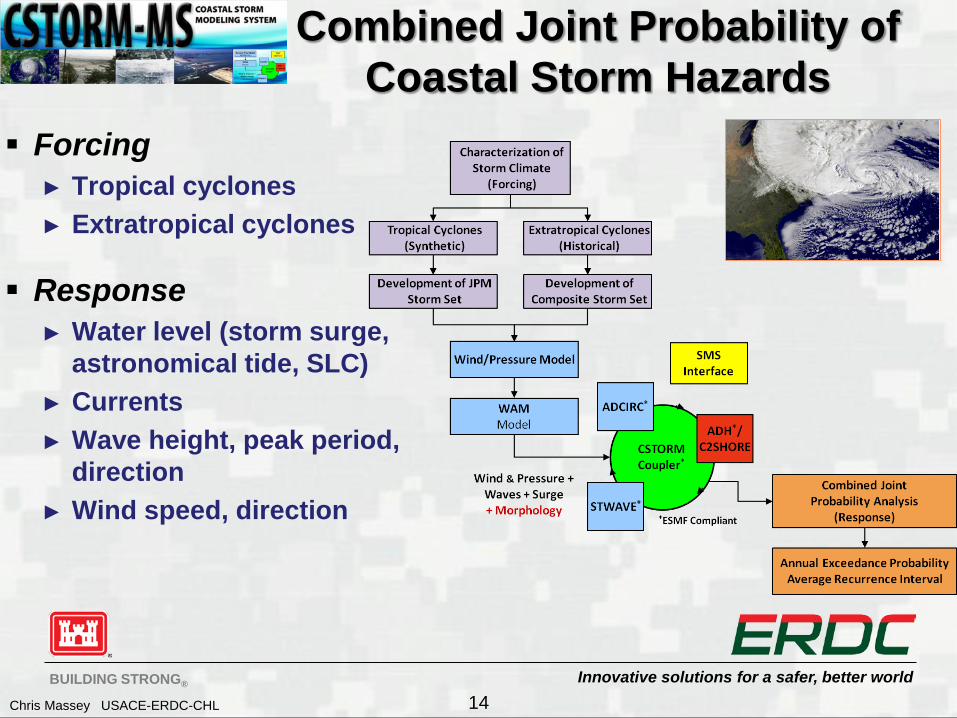
Combined Joint Probability of Coastal Storm Hazards
Forcing ► Tropical cyclones ► Extratropical cyclones
Response ► Water level (storm surge,
astronomical tide, SLC) ► Currents ► Wave height, peak period,
direction ► Wind speed, direction
14
Innovative solutions for a safer, better world BUILDING STRONG®
Chris Massey USACE-ERDC-CHL
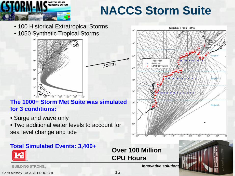
NACCS Storm Suite
The 1000+ Storm Met Suite was simulated for 3 conditions: • Surge and wave only • Two additional water levels to account for sea level change and tide Total Simulated Events: 3,400+
• 100 Historical Extratropical Storms • 1050 Synthetic Tropical Storms
15
Over 100 Million CPU Hours

Innovative solutions for a safer, better world BUILDING STRONG®
Chris Massey USACE-ERDC-CHL
CSTORM Production System
16
• The CSTORM Production System (CSTORM-PS) makes use of standard Linux/Unix tools (bash scripting) and readily available open source software, Python
• The production system allows for • Rapid preparation of necessary input files for individual CSTORM-MS
production runs (Reduces chances for human error) • Execution of the simulation • Execution of the CSTORM Visualization and Report tool • Efficient file storage and archival
• The production system is general enough for expanded use in future projects
Setup Simulation
Prep ADCIRC for
Parallel Execute
CSTORM Visualize &
Stats Compress Outputs
Tar Results Together
Archive Results

Innovative solutions for a safer, better world BUILDING STRONG®
Chris Massey USACE-ERDC-CHL
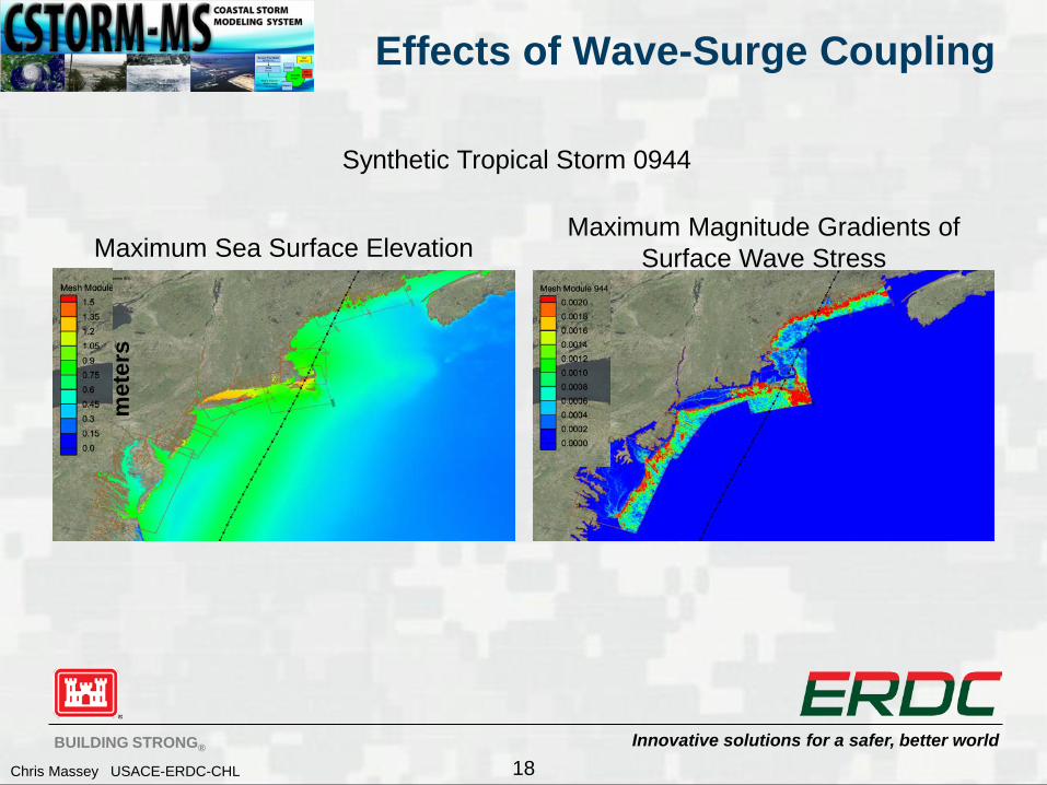
Effects of Wave-Surge Coupling
17
Maximum Wind Speeds Minimum Central Pressure
Synthetic Tropical Storm 0944 m
/s
mb
Innovative solutions for a safer, better world BUILDING STRONG®
Chris Massey USACE-ERDC-CHL
Effects of Wave-Surge Coupling
18
Maximum Sea Surface Elevation Maximum Magnitude Gradients of
Surface Wave Stress
Synthetic Tropical Storm 0944 m
eter
s

Innovative solutions for a safer, better world BUILDING STRONG®
Chris Massey USACE-ERDC-CHL
Effects of Wave-Surge Coupling
19
Difference Max. Sea Surface Elevation (Wave Coupling – No Waves)
Difference Max. Sea Surface Elevation (Wave Coupling – No Waves)
Synthetic Tropical Storm 0944 m
eter
s
met
ers

Innovative solutions for a safer, better world BUILDING STRONG®
Chris Massey USACE-ERDC-CHL
Effects of Wave-Surge Coupling
20
Difference Max. Sea Surface Elevation (Wave Coupling – No Waves)
Topography/Bathymetry
Synthetic Tropical Storm 0944 m
eter
s
met
ers

Innovative solutions for a safer, better world BUILDING STRONG®
Chris Massey USACE-ERDC-CHL
Effects of Wave-Surge Coupling
21
Maximum Significant Wave Heights Difference Maximum Significant Wave Heights (With Surge – No Surge)
Synthetic Tropical Storm 0944
Innovative solutions for a safer, better world BUILDING STRONG®
Chris Massey USACE-ERDC-CHL
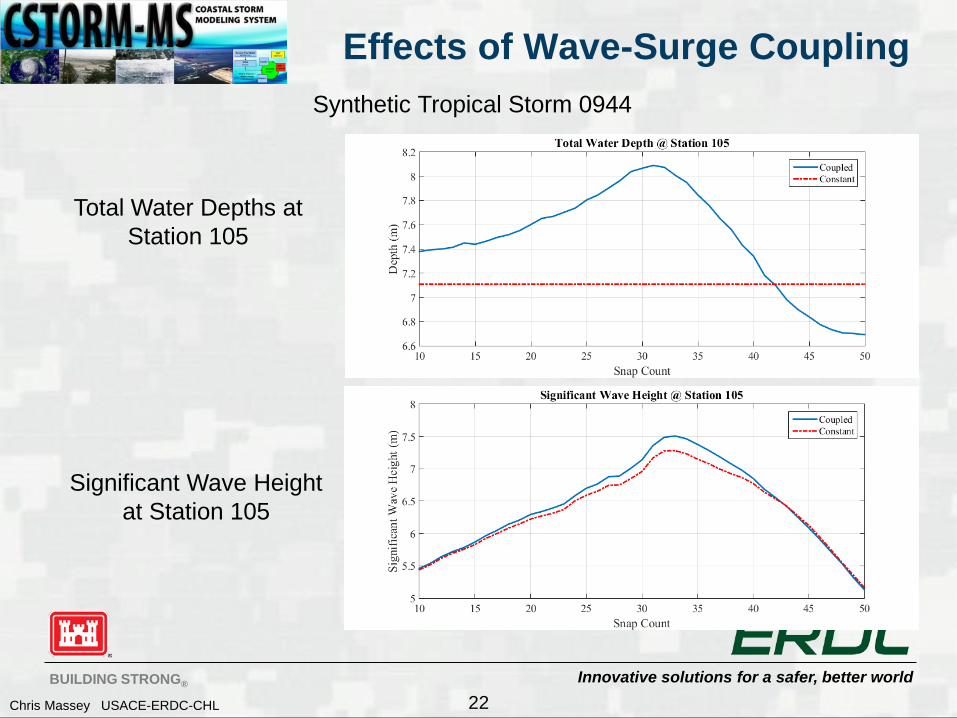
Effects of Wave-Surge Coupling
22
Total Water Depths at Station 105
Significant Wave Height at Station 105
Synthetic Tropical Storm 0944

Innovative solutions for a safer, better world BUILDING STRONG®
Chris Massey USACE-ERDC-CHL
Effects of Wave-Surge Coupling
23
Total Water Depths at Station 2161
Significant Wave Height at Station 2161
Synthetic Tropical Storm 0944
2.7m

Innovative solutions for a safer, better world BUILDING STRONG®
Chris Massey USACE-ERDC-CHL
CSTORM System Components 2015
Winds/Pressure: PBL Cyclone Model Waves:
► Regional: WAM ► Nearshore: STWAVE* ► Unstructured WaveWatch3* (FY15/FY16)
Circulation/Surge: ► ADCIRC* ► ADH*
Morphology: SEDLIB/C2Shore Coupling Framework: CSTORM-MS* Graphical User Interface: SMS Overland Flow – GSSHA (FY16/FY17)
Earth System Modeling Framework (ESMF) Compliance • Multiple federal agency support ESMF • ESMF compliant models are readily available to be linked with each other and
with other agencies’ ESMF compliant models. • Individual models stay virtually autonomous when coupling.

Innovative solutions for a safer, better world BUILDING STRONG®
Chris Massey USACE-ERDC-CHL
• Leveraging USACE regional coastal studies • Gathering historical measurements and high-fidelity
climate, surge, and wave modeling results • Creating national storm database • Web tool with Google Earth map interface • Data mining and analysis tools (plotting, extremal
analysis) • Surrogate modeling from database (high-fidelity
surge prediction layer)
1-m Flood in New Orleans
Storm Track, Flood Level, Probabilities
Coastal Hazards System ( CHS )
25
https://chs.erdc.dren.mil

Innovative solutions for a safer, better world BUILDING STRONG®
Chris Massey USACE-ERDC-CHL
Summary
26
• CSTORM-MS is an efficient, robust, extensible modeling system for quantifying the risk of coastal communities to storm events. • Its’ streamlined workflow saves time and reduces both computational and personnel cost. • Model data feeds into CHS for easy access and reuse purposes. • Stay connected to other users and get help via the Knowledge Hub
https://chs.erdc.dren.mil Coastal Hazards System Webpage

Innovative solutions for a safer, better world BUILDING STRONG®
Chris Massey USACE-ERDC-CHL
Basic Directory Hierarchy
28
CSTORM_Sims
Historical
ExtraTropical
Tropical RNC
Synthetic Tropical
RNC = Run_NM_Tides_TN_SLC_SN_RFC_RN_WAV_WN_GCP_PN_UID_IDV • Run_NM = Storm Number, NM = 0001 to 1050 • Tides_TN = Tidal Scenario, TN = 0 to 5 • SLC_SN = Sea Level Change/Steric Adjustment Scenario, SN = 0 to 2 • RFC_RN = River Forcing Conditions, RN = 0 to 2 • WAV_WN= Waves Off/On, WN = 0 or 1 • GCP_PN = Grid Configuration Packet • UID_IDV = User Identification, IDV = person performing simulation