u.s. department of the interior u.s. … · u.s. department of the interior u.s. geological survey...
TRANSCRIPT

U.S. DEPARTMENT OF THE INTERIOR
U.S. GEOLOGICAL SURVEY
COSTA RICA VOLCANO PROFILE
by
Cynthia M. Stine1
Norman G. Banks1
Open-File Report 91-591
This report is preliminary and has not been reviewed for conformity with U.S. Geological Survey editorial standards (or with the North American Stratigraphic code). Any use of trade, product, or firm names is for descriptive purposes only and does not imply endorsement by the U.S. Government.
*U.S. Geological SurveyDavid A. Johnston Cascades Volcano Observatory 5400 MacArthur Blvd. Vancouver, WA. 98661

TABLE OF CONTENTS
Introduction.......................................................^Background.........................................................Tectonic setting..................................................................................................................................................5General description of volcanic hazards.......................................................................................................5
TephrafaU...........................................^Pyroclastic flows and surges..............................................................................................................6Mudflows...............................................................................................................................................6Lava flows..............................................................................................................................................6Debris avalanches................................................................................................................................?Volcanic gases and acid rain...........................................................................................,.................?Ballistic projectiles...............................................................................................................................?Earthquakes..........................................................^Atmospheric shock waves..................................................................................................................8
Individual volcanoes..........................................................................................................................................9Orosi.................................................^Cacao....................................................................................................................................................12Rincdn de la Vieja.............................................................................................................................15Miravalles............................................................................................................................................19Tenorio...-.-.-.-..-----..---.------.--.-----.-----..-.--.-.-..-.---.-.-.--..-...--^^Arenal......................................................................................................^Platanar...................................................Pods... ---..-..--..-..-..........-.-..-......--.- ..-. .. ^^Barva.......-............-...-......--.......---....---...........-..-.-.-.-..-.......-...-.-..----^^Irazu---...--.-.....-...-..--....-........--...-.-.....--.--....-...---.-...--..-...-....-^Turrialba--.-...-....--.---..--.....-.-.......-......-..--.--.---......---.-....-^
Civil Defense hierarchy and disaster preparedness.................................................................................53General country data......................................................................................................................................53
Population...............................................................Time zone............................................................................................................................................53Currency..............................................................Phone exchange.-..-...--......-.-.......-..-..-.-.-............-......-.... . . . ...................53Rainy season....-........--..-.-.......-..-..-......-.-..-.-...--...............-.........-............ . .53Precipitation..----....-........-.-..---.-....-..-.--.....-..--......-...-..-..-.-....-..-...-.......-.-........-.......54Temperature.................................................................................................................54Atmospheric pressure...--......-......---.....-..-.-......---........-..-- . .. .55Winds..--..--.--..-..--...-..-..........-..-..--.-.-....---....--..-..-.--...-.--....---.-.---..---.--.-...-..55Electric supply....-....-..--.-..-.......--.--....-..-......-..--...-....-.-............-.-----. .. .55Communications-.---...----....------.--.--.---..-.---...-.--.---------.----.-.--.-......--.--55
Geologic organizations and information sources. . ................................. 56Other earth scientists and organizations........-...-..........-......-.. . ........................59

COSTA RICA VOLCANO PROFILE
By Cynthia M. Stine and Norman G. Banks
INTRODUCTION
Volcanic eruptions have caused considerable damage in Costa Rica in the past and they are certain to do so again in the future. In developing countries, the number of victims of natural catastrophes increases approximately 6% a year, a rate approximately double that of population growth (Masure, in press). Population increases accompanied by deforestation, agriculture and rapid, poorly planned urbanization cause further encroachment onto the slopes of volcanoes, greatly increasing the population at risk from eruptions. However, future losses can be minimized through preventative planning.
A necessary first step in this planning is the analysis of current and existing preparedness for occurrence of natural disaster, followed by an active program in response to this analysis. For volcano hazard mitigation, this first step includes geologic evaluation and demographic studies, followed by land-use zoning, public education, monitoring for early warning, and establishment of alarm, evacuation, and rescue systems.
This report provides background data that should be useful in the evaluation of and preparation for volcanic hazards in Costa Rica. It is intended to serve as an information source for donor nations and to assist their efforts in preparation for unrest at high-risk volcanoes. Included are descriptions of the geologic setting and current evaluation of activity, hazards, and risk for each active volcano in Costa Rica. Their locations and general geographic information are provided with descriptions of historical eruptions. Volcano monitoring stations that could be precisely located appear on the maps. Map references have been included for each volcano; sources of maps and aerial photographs are noted in the section entitled Geologic organizations and information sources. Also included are evaluations of the near-field population at risk and a listing of in-country geologic and civil defense organizations with their current activities and status in preparedness. This general information about Costa Rica should facilitate a rapid response to a future volcanic emergency and be useful in activities that prepare for these crises.
Information sources were the demographic and scientific literature, resident contributors, and on-site reconnaissance by the authors. Collection of the data was jointly supported by the U.S. Geological Survey's Volcano Crisis Assistance Team (VCAT) and the Office of Foreign Disaster Assistance (OFDA) through the USGS/OFDA Volcano Early-warning and Disaster Assistance Program (VDAP). The in-country contributors included Jorge Barquero, Rudolfo Van der Laat, Federico Guendel, and Eric Ferndndez of Observatorio Vulcanol6gico y Sismoldgico de Costa Rica (OVSICORI), and Sergio Mora and Guillermo Alvarado of Institute Costarricense de Electricidad (ICE).
An effort was made to obtain current, reliable data; however, hazard mitigation activities in Costa Rica are in progress and conditions can change faster than updates can be issued. Therefore, this report is preliminary and will be subject to updates as information becomes available.
BACKGROUND
Costa Rica occupies one of the geologically most active areas in the world and is therefore susceptible to a variety of natural hazards including damaging earthquakes, landslides,
1
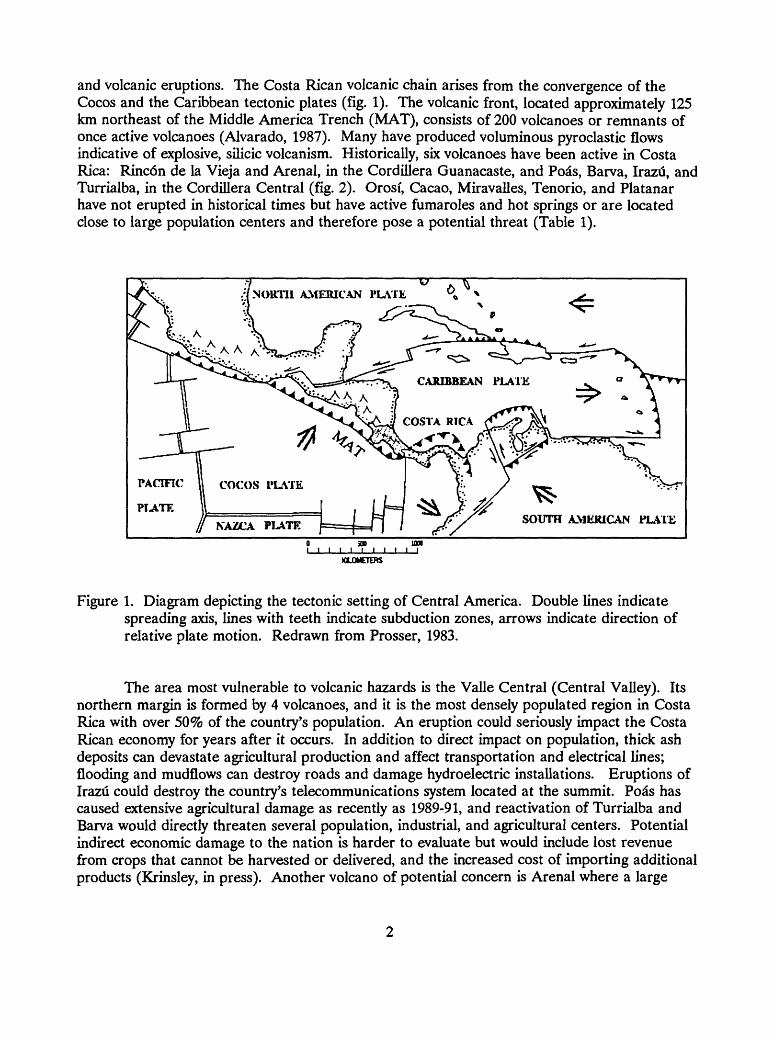
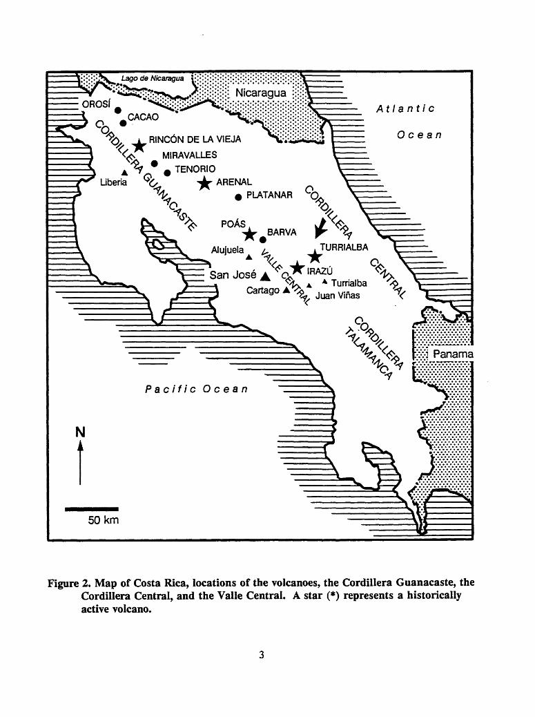
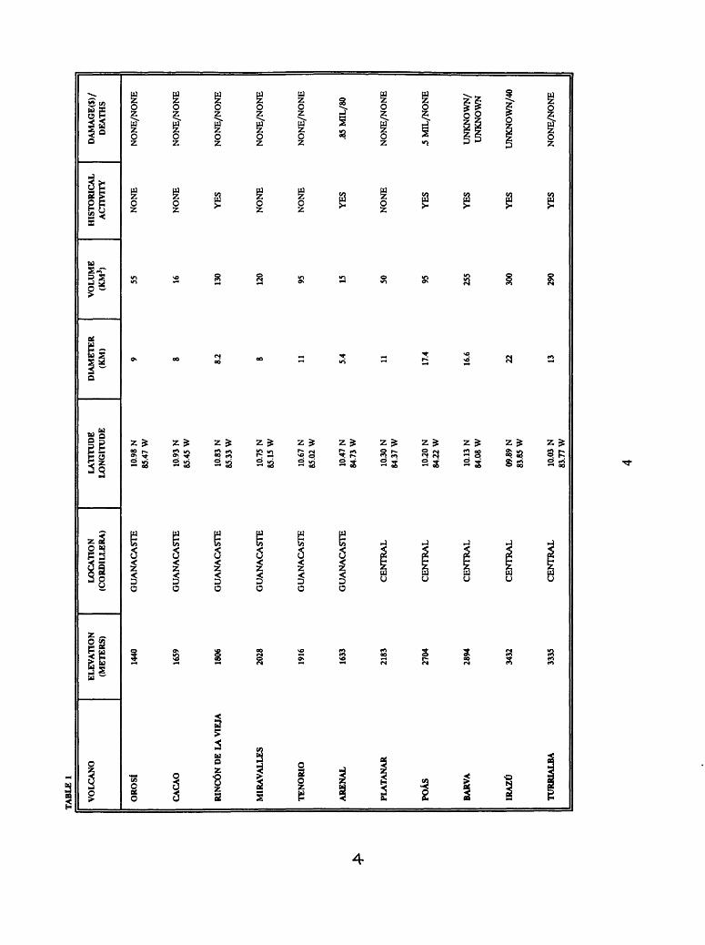
and volcanic eruptions. The Costa Rican volcanic chain arises from the convergence of the Cocos and the Caribbean tectonic plates (fig. 1). The volcanic front, located approximately 125 km northeast of the Middle America Trench (MAT), consists of 200 volcanoes or remnants of once active volcanoes (Alvarado, 1987). Many have produced voluminous pyroclastic flows indicative of explosive, silicic volcanism. Historically, six volcanoes have been active in Costa Rica: Rincdn de la Vieja and Arenal, in the Cordillera Guanacaste, and Pods, Barva, Irazti, and Turrialba, in the Cordillera Central (fig. 2). Orosi, Cacao, Miravalles, Tenorio, and Platanar have not erupted in historical times but have active fumaroles and hot springs or are located close to large population centers and therefore pose a potential threat (Table 1).
NORTH AMERICAN PLATE
SOUTH AMKJUCAN PLATE
o ao ion i i i i i i i i i i i
KLOMETERS
Figure 1. Diagram depicting the tectonic setting of Central America. Double lines indicate spreading axis, lines with teeth indicate subduction zones, arrows indicate direction of relative plate motion. Redrawn from Prosser, 1983.
The area most vulnerable to volcanic hazards is the Valle Central (Central Valley). Its northern margin is formed by 4 volcanoes, and it is the most densely populated region in Costa Rica with over 50% of the country's population. An eruption could seriously impact the Costa Rican economy for years after it occurs. In addition to direct impact on population, thick ash deposits can devastate agricultural production and affect transportation and electrical lines; flooding and mudflows can destroy roads and damage hydroelectric installations. Eruptions of Irazu could destroy the country's telecommunications system located at the summit. Pods has caused extensive agricultural damage as recently as 1989-91, and reactivation of Turrialba and Barva would directly threaten several population, industrial, and agricultural centers. Potential indirect economic damage to the nation is harder to evaluate but would include lost revenue from crops that cannot be harvested or delivered, and the increased cost of importing additional products (Krinsley, in press). Another volcano of potential concern is Arenal where a large
l-ago & Nicaragua v,'\':''
Q, A RINCON DE LA VIEJA
MIRAVALLES
TENORIO
POAS^BARVA r ^
Alujuela ^ .TURRIALBA
SanJoseA^Q^ IRA2° ^ v^>t^ A A Turrialba x> A
CartagoA^ ,.._ x/;^0 ^ '
£vj Panama
Pacific Ocean
Figure 2. Map of Costa Rica, locations of the volcanoes, the Cordillera Guanacaste, the Cordillera Central, and the Valle Central. A star (*) represents a historically active volcano.
TA
BL
E 1
VO
LCA
NO
EL
EVA
TIO
N
LOC
ATI
ON
LA
TITU
DE
(MET
ERS)
(C
OR
DIL
LER
A)
LON
GIT
UD
E
OR
OSf
14
40
GU
AN
AC
AST
E
10.9
8 N
85
.47
W
CA
CA
O
Id59
G
UA
NA
CA
STE
10
.93
N
85.4
5 W
RIN
CO
N D
E LA
VIE
JA
1806
G
UA
NA
CA
STE
10
.83
N
85.3
3 W
MIR
AV
ALL
ES
2028
G
UA
NA
CA
STE
10
.75
N
85.1
5 W
TE
NO
RIO
19
16
GU
AN
AC
AST
E
10.6
7 N
85
.02
W
AR
ENA
L 16
33
GU
AN
AC
AST
E
10.4
7 N
84
.73
W
PLA
TAN
AR
21
83
CE
NT
RA
L
10.3
0 N
84
.37
W
POA
S 27
04
CE
NT
RA
L
10 JO
N
84.2
2 W
BARV
A
2894
C
EN
TR
AL
10
.13
N
84.0
8 W
IRA
ZU
3432
C
EN
TR
AL
09
.89
N
83.8
5 W
TUR
RIA
LBA
33
35
CE
NT
RA
L
10.0
3 N
83
.77
W
DIA
MET
ER
VO
LUM
E H
ISTO
RIC
AL
DA
MA
GE(
$)/
(KM
) (K
M3)
A
CTI
VIT
Y
DEA
THS
9 55
N
ON
E
NO
NE
/NO
NE
8 16
N
ON
E
NO
NE
/NO
NE
82
130
YES
N
ON
E/N
ON
E
8 12
0 N
ON
E
NO
NE
/NO
NE
11
95
NO
NE
N
ON
E/N
ON
E
5.4
15
YE
S .8
5 M
IL/8
0
11
50
NO
NE
N
ON
E/N
ON
E
17.4
95
Y
ES
.5 M
IL/N
ON
E
16.6
25
5 Y
ES
UN
KN
OW
N/
UN
KN
OW
N
22
300
YE
S U
NK
NO
WN
/40
13
290
YES
N
ON
E/N
ON
E
eruption could damage the Sangregado Hydroelectric Plant, which supplies 60% of the electricity for the country.
Costa Rica is among the best-prepared Latin American countries to deal with future unrest at its volcanoes. A dedicated cadre of geoscientists, technicians, and students has been actively pursuing evaluation and mitigation of the seismic and volcanic hazards of the country for decades. Three main scientific groups are major contributors: Observatorio Vulcanoldgico y Sismologico (OVSICORI) affiliated with the Universidad Nacional (UNA), Institute Costarricense de Electricidad (ICE), and the Universidad de Costa Rica (UCR). Through self- motivation and donor-country support, these organizations possess the trained staffs and instrumentation required to adequately deal with the anticipated seismic and volcanic unrest in Costa Rica. Their combined capabilities in seismic, deformation, and geochemical monitoring programs are among the best in Latin America. In spite of these major accomplishments, Costa Rica is not thoroughly prepared for the onset of volcanic unrest at all of its high-risk volcanoes. There are, for example, few detailed geologic maps of Costa Rican volcanoes, few hazard- zonation maps, and coordination between the two main geoscience groups has at times been poor.
Long-term donor-country support and training in the use of instrumentation that has already been provided to Costa Rica are needed to maintain a successful assistance program. Parts for volcano monitoring equipment are difficult or impossible to obtain locally and are expensive to import. Equipment that has been brought on line must be maintained and not allowed to fall into disuse when installation phases of the programs are completed. In addition, donor-country assistance is needed to expand and upgrade current capabilities.
TECTONIC SETTING
Costa Rica is located on an active, convergent plate boundary where the Cocos Plate is being subducted to the northeast beneath the Caribbean Plate. One consequence of this subduction is an 1100-km-long, NW-SE-trending volcanic chain that stretches from Mexico through the middle of Costa Rica (Weyl, 1980). The part of this chain in northwest Costa Rica is referred to as the Cordillera de Guanacaste and is offset about 40 km to the southwest from the Nicaraguan chain. The remainder of the Costa Rican volcanoes, southeast of the Cordillera de Guanacaste, are located in the Cordillera Central (Stoiber and Carr, 1973). There are no active volcanoes in Costa Rica south of the Cordillera Central.
GENERAL DESCRIPTION OF VOLCANIC HAZARDS
Tephra fallMany volcanic eruptions produce airborne tephra which is dispersed in fan-shaped
patterns downwind of the vent. In the proximal areas, death related directly to tephra fall is rare. However, death and other losses from indirect causes including collapse of roofs, breakage of electrical and communications lines, contamination of water supplies, damage to machinery and airplanes, and destruction of agricultural grazing land and crops can be extensive (Scott, 1989). Tephra deposition accompanied or followed by heavy rainfall can generate destructive mudflows. Conditions that favor generation of such mudflows may last long after ash is deposited. In Costa Rica the prevailing wind directions will direct most tephra fall deposits to the west of the source volcano. Thus, the heavily populated Valle Central, the location of the
capital city, San Jos6, could be severely impacted by a large eruption of any of the four volcanoes forming the northeastern border of the valley. During the 1963 eruption of Irazu, tephra was deposited in the capital, 24 km from the summit. The Costa Rican Ministry of Agriculture estimated that tephra from this eruption damaged 112,000 acres of land (Murata and others, 1966).
Pyroclastic flows and surgesPyroclastic flows and surges are gravity-driven flows of hot (300 to 800 degrees C)
pyroclastic material and gases which destroy everything in their path. Small to moderate-sized flows tend to travel unrestrained by topography near their sources but often become channelized on or beyond the flanks of a volcano. They travel at velocities ranging from 30 to 300 km/hr (Scott, 1989). In 1968, Arena! produced violent explosions and small pyroclastic flows that killed 80 people living within 5 km of the summit (Melson and Sa"enz, 1973). Large pyroclastic flows can remain unrestrained by topography for tens or even hundreds of kilometers from their vents. The pyroclastic flow associated with the blast at Mount St. Helens traveled in this manner for as many as 30 km. There have not been any large pyroclastic flows in Costa Rica during historical times; however, huge ash flow sheets are the dominant Quaternary volcanic product by volume in Costa Rica (Weyl, 1980).
MudflowsMudflows are hot or cold, water-saturated debris flows that can originate on the flanks of
a volcano. They are confined to drainages and outflow fans but can travel quite far at speeds up to 110 km/hr (Blong, 1984). Mudflows pose a great threat to downstream populations, which may be lulled into a false sense of security owing to their great distance from the volcano.
Mudflows may be primary or secondary in origin. Primary mudflows are generated by eruptions through crater lakes, overrunning and incorporation of streamflow by pyroclastic flows, and melting of ice and snow by pyroclastic flows. Secondary mudflows occur through breaking of natural and man-made dams or through mobilization of pyroclastic deposits by torrential rainfall.
Historical and prehistorical records indicate that mudflows frequently affected the Valle Central. Large destructive mudflows would most likely result from the remobilization of erupted ash, pumice, and pyroclastic-flow deposits by heavy rainfall. Such events occurred during the Irazu eruption of 1963-1965, in which over 20 people were killed and 400 homes, some factories, a major highway, and a railway line were destroyed. (Murata and others, 1966). Loss of life can be minimized through prior warning, evacuation, land-use zoning, and the construction of barriers and diversion channels.
Lava flowsLava flows are not expected to cause many deaths in Costa Rica. Most move slowly, and
the majority do not travel far beyond the flanks of a volcano. Due to the slow advance of most lava flows, a warning period of hours to days is usually provided. However, they do cause great property damage, and the stratigraphic record reveals that many Costa Rican volcanoes have produced large lava flows in the past and are therefore likely to do so in the future. Effects of lava flows include damage to structures by ignition, exerting force on and destroying walls, and burial. They also cut off roads, railway lines, and electric and water supplies (Blong, 1984). Collapse of the .front of a thick lava flow can generate pyroclastic flows that travel at high velocity several kilometers and advance far beyond lava flow.
Debris avalanchesDebris avalanches are caused by the collapse of a portion of a volcano; they completely
destroy everything in their path. Debris avalanches may travel over 100 km/hr and have caused over 20,000 fatalities in historical times (Siebert, 1984). Some travel over 10 km from their sources; several can be traced for 50 to 100 km and cover areas of 500 to 1500 km2. Slope failure associated with debris avalanches can trigger explosive activity, such as a lateral blast, by releasing the pressure of a hydrothermal-magmatic system. Associated hazards include rapid introduction of volcanic debris into drainages, which can generate destructive mudflows. There may also be generation of secondary mudflows through the impoundment of streams and failure of debris dams. Historical records indicate that catastrophic debris avalanches have occurred 6 times in the last century (Siebert, 1984). In Costa Rica, prehistoric debris avalanches occurred at Miravalles, Cacao, and Turrialba in late Quaternary time. The probability of a debris avalanche increases where portions of a volcanic edifice are hydrothermally altered and where the upper flanks are oversteepened. Debris avalanches can occur by simple gravitational collapse or be triggered by intrusive activity or by shaking associated with local or regional earthquakes.
Volcanic gases and acid rainVolcanic gases and acids released directly from a vent or created through interaction of
the gases with the atmosphere include carbon monoxide, carbon dioxide, sulfuric acid, hydrochloric acid, hydrofluoric acid, carbonic acid, and ammonia. The effect of these gases and acids generally decreases downwind of the vent. Rain passing through a gas-laden plume absorbs these pollutants and can consequently contaminate and acidify water supplies. Acid rain can burn vegetation, and cause eye and respiratory problems. Gas and acid components adsorbed on tephra particles frequently cause digestive or more serious problems for grazing animals (Blong, 1984). In 1988, increased fumarolic activity at Pods produced acid vapors that damaged vegetation and caused continuing health problems for nearby inhabitants. Coffee crop losses were estimated to be in excess of $0.5 million (SEAN, Barquero, 1989, v. 14, no. 3).
Ballistic projectilesBallistic projectiles are fragments of rock and lava of variable size that are ejected from
a vent at high speeds. Trajectories of these projectiles are generally not affected by the wind. Fragments become finer-grained with distance from the vent. The greatest hazard is from the force of impact and heat (Scott, 1989). Grass and forest fires sometime accompany impact of hot ballistics. These types of projectiles were a major source of destruction in the 1968 eruption of Arenal.
EarthquakesVolcanic earthquakes are associated with the movement of magma in volcanic areas and
frequently precede or accompany eruptions. If volcanoes are adequately monitored, earthquake trends can be used to forecast eruptions. Large volcanic earthquakes can cause damage.
Observatorio VulcanohSgico y Sismoldgico (OVSICORI) of the Universidad Nacional (20 stations) and Institute Costarricense de Electricidad (ICE)-Secci6n de Sismologfa e Ingenieria Sismica, in association with the Universidad de Costa Rica (15 stations), have been monitoring both tectonic and volcanic seismicity in Costa Rica for decades.

Atmospheric Shock WavesSome eruptions produce strong atmospheric shock waves when volcanic material and
gases are ejected at high velocity from the vent. The energy of a shock wave decreases with distance from a vent; however, damage to buildings and windows has occurred as far as 10 km from the vent. Some eruptions are reported to have broken windows hundreds of kilometers from the source (Scott, 1989).

INDIVIDUAL VOLCANOES from North to SouthOROSI (sometimes referred to as Gongora which is actually the name of another conesoutheast of Orosfl
GENERAL GEOLOGIC SETTING: Orosi is a composite volcano located 17 km SW of the Nicaraguan border at the NW end of the Cordillera de Guanacaste (fig. 2, 3). The most recently active vent is one of 4 clustered, eroded cones (Mooser and others, 1958). The crater, breached to the southwest, is large and poorly preserved. Also in the area is Cerro Orosilito, a small cone to the southeast between Orosi and Cacao, and a cluster of Tertiary cones 7 km to the WNW.
ERUPTIVE STYLE AND HAZARDS: There are very few geological data available to evaluate Orosi. The most recent dated event, based on radiocarbon dating, is a large lahar which moved south from the summit around 4000 ybp (Melson and others, 1988).
EVALUATION OF ACTIVITY AND RISK (1989): All deposits from Orosi are very old (thick well-developed soils), and the slopes are deeply dissected and covered with forests. There have been no geophysical or visual signs of activity. Therefore, the probability of an eruption in the foreseeable future is very small. However, sector collapse has a higher probability. The oversteepened slopes are deeply weathered and soil-covered, and old megabreccia deposits, occurring to the west of the volcano, indicate predisposition for such events at Orosi (field reconnaissance by Banks).
There are no geologic studies available with which to evaluate eruption recurrence intervals or potential for large infrequent eruptions. Eruptions are reported for 1844 and 1849 although Orosi was at the time and still is covered with thick vegetation (Mooser and others, 1958), however, these reports are probably in error. A study of the historical record indicates that these eruptions took place at Rincdn de la Vieja which is located approximately 20 km SE of Orosi in a remote part of Costa Rica (Barquero, J., pers. comm., 1988).
PROXIMAL POPULATION AT RISK: The area is remote, therefore few people in the near field are at risk. The volcano is located in the Guanacaste National Park, and future development of the area will be restricted.
OROSf*
QUADRANT POPUL 0-5
NE
SE
SW
NW
ATION POPULATION KM 5-10 KM
63
24
39
(Data from G. Alvarado, ICE)* Population figures are for quadrants. Populations located along drainages are at thegreatest risk.

U.S
. DE
PAR
TM
EN
T O
F TH
E IN
TE
RIO
R
U.S. G
EO
LO
GIC
AL
SfflV
EY
OPE
N-FIL
E R
EPO
RT
9
1-5
91
CO
NT
OU
R IN
TE
RV
AL = 20 M
Figure 3. T
opographic map of O
rosi.
This m
ap is preliminary and .has not b
een review
ed for conformity w
ith 11
U.S. G
eological Survey editorial standards. A
ny use of trade, firm, or product
names is for descriptive purposes only and d
oes not imply endorsem
ent by the U
.S. Governm
ent.
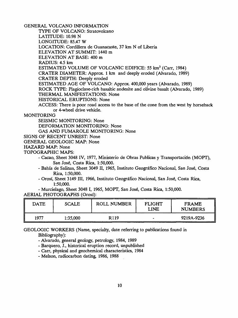
GENERAL VOLCANO INFORMATIONTYPE OF VOLCANO: StratovolcanoLATITUDE: 10.98 NLONGITUDE: 85.47 WLOCATION: Cordillera de Guanacaste, 37 km N of LiberiaELEVATION AT SUMMIT: 1440 mELEVATION AT BASE: 400 mRADIUS: 4.5 kmESTIMATED VOLUME OF VOLCANIC EDIFICE: 55 km3 (Carr, 1984)CRATER DIAMETER: Approx. 1 km and deeply eroded (Alvarado, 1989)CRATER DEPTH: Deeply erodedESTIMATED AGE OF VOLCANO: Approx. 400,000 years (Alvarado, 1989)ROCK TYPE: Plagioclase-rich basaltic andesite and olivine basalt (Alvarado, 1989)THERMAL MANIFESTATIONS: NoneHISTORICAL ERUPTIONS: NoneACCESS: There is poor road access to the base of the cone from the west by horseback
or 4-wheel drive vehicle. MONITORING
SEISMIC MONITORING: NoneDEFORMATION MONITORING: NoneGAS AND FUMAROLE MONITORING: None
SIGNS OF RECENT UNREST: None GENERAL GEOLOGIC MAP: None HAZARD MAP: None TOPOGRAPHIC MAPS:
- Cacao, Sheet 3048 IV, 1977, Ministerio de Obras Publicas y Transportacidn (MOPT), San Jose, Costa Rica, 1:50,000.
- Bahia de Salinas, Sheet 3049 II, 1965, Institute Geogrdfico Nacional, San Jose, Costa Rica, 1:50,000.
- Orosi, Sheet 3149 III, 1966, Institute Geogrdfico Nacional, San Jose, Costa Rica, 1:50,000.
- Murcielago, Sheet 3048 I, 1965, MOPT, San Jos6, Costa Rica, 1:50,000. AERIAL PHOTOGRAPHS (Orosi):
DATE SCALE ROLL NUMBER FLIGHT LINE
FRAME NUMBERS
1977 1:35,000 R119 - 9219A-9236
GEOLOGIC WORKERS (Name, specialty, date referring to publications found in Bibliography):- Alvarado, general geology, petrology, 1984, 1989- Barquero, J., historical eruption record, unpublished- Carr, physical and geochemical characteristics, 1984- Melson, radiocarbon dating, 1986, 1988
10

CACAO
GENERAL GEOLOGIC SETTING: Cerro Cacao is located in the Cordillera de Guanacaste, 6 km SE of Volcan Orosi (fig. 2). The volcano is deeply eroded, has well developed soils, and is covered with thick vegetation (fig. 4). The crater is breached to the southwest and contains a dome. A smaller cone, Volcan Pedregal, breached to the west, is located 3 km SW of Cacao.
ERUPTIVE STYLE AND HAZARDS: Debris avalanche deposits from Cacao occur 3.5 km SW of the volcano in the Rio Gdngora valley and are believed to be 6000 years old (Castillo, 1977). Altered rhyolite, perhaps part of an earlier silicic dome, is found in these deposits. An eroded dome occurs in the breach left by the debris avalanche, and a thin 3,500 year old tephra- fall deposit from Rincon de la Vieja overlies the avalanche deposits (Melson and others, 1986). No other geologic data are available for Cacao.
EVALUATION OF ACTIVITY AND RISK (1989): The flanks of Cacao are deeply dissected and covered by thick, well-developed soils. There have been no geophysical or visual signs of historical unrest. The presence of rhyolite on the southwest flank, perhaps the remnant of an old dome transported in a debris avalanche, suggests that the volcano may have been highly explosive in the late Quaternary.
PROXIMAL POPULATION AT RISK: The area is remote, therefore few people are at risk.
CACAO
QUADRANT
NE
SE
SW
NW
POPULATION 0-5 KM
-
-
3
-
POPULATION5-10 KM
66
99
24
-
(Data from G. Alvarado, ICE)
GENERAL VOLCANO INFORMATIONTYPE OF VOLCANO: StratovolcanoLATITUDE: 10.93 NLONGITUDE: 85.45 WLOCATION: Cordillera de GuanacasteELEVATION AT SUMMIT: 1659 mELEVATION AT BASE: 700 mRADIUS: 4 kmESTIMATED VOLUME OF VOLCANIC EDIFICE: 16 km3CRATER DIAMETER: Deeply erodedCRATER DEPTH: Deeply erodedESTIMATED AGE OF VOLCANO: Approx. 400,000 years (Alvarado, 1989)
12
U.S. D
EPA
RT
ME
NT
OF T
HE
INT
ER
IOR
U
.S. GE
OL
OG
ICA
L SU
RV
EY
10.99- N
OPE
N-FIL
E R
EPO
RT
9
1-5
91
CO
NT
OU
R IN
TE
RV
AL
=2
0 M
Figure 4. T
opographic map of C
acao.14
This m
ap is preliminary and has not b
een review
ed for conformity w
ith U
.S. Geological Survey editorial standards.
Any use of trade, firm
, or product nam
es is for descriptive purposes only and does not im
ply endorsement by the
U.S. G
overnment.
ROCK TYPE: Augite andesite and rhyolite (Alvarado, 1989)THERMAL MANIFESTATIONS: NoneHISTORICAL ERUPTIONS: NoneACCESS: There is poor access from the west to the base of the cone by 4-wheel drive
vehicle. MONITORING
SEISMIC MONITORING: NoneDEFORMATION MONITORING: NoneGAS AND FUMAROLE MONITORING: None
SIGNS OF RECENT UNREST: NoneGENERAL GEOLOGIC MAP: Yes, 1:50,000 by Castillo R. (1977) HAZARD MAP: None TOPOGRAPHIC MAPS:
- Cacao, Sheet 3048 IV, 1977, MOPT, San Jose, Costa Rica, 1:50,000. AERIAL PHOTOGRAPHS (Cacao):
DATE SCALE ROLL NUMBER FLIGHT LINE
FRAME NUMBERS
1977 1:35,000 R119 - 9219A-9236
GEOLOGIC WORKERS (Name, specialty, date referring to publications found in Bibliography):- Alvarado, general geology, 1989- Barquero, J., historical eruption record, unpublished- Castillo, reconnaissance geology, 1977- Kempter, geology, unpublished
13

RINCON de la VIEJA
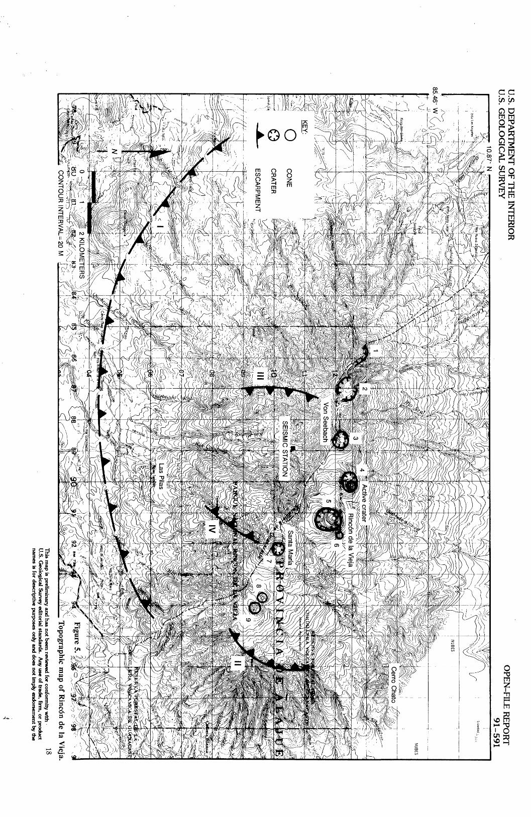
GENERAL GEOLOGIC SETTING: Rincdn de la Vieja is located in the Cordillera de Guanacaste, 30 km south of the Nicaraguan border. It consists of a large composite volcano with a series of 9 aligned cones and craters forming a NW-SE-trending ridge (Alvarado, 1989) (fig. 2, 5). The youngest craters are to the northwest and suggest a northwestward migration of activity. The older craters are hydrothermally altered. The most recently active crater is located 1 km NW of the main cone and contains a crater lake. The Von Seebach Cone and the Volcdn Santa Maria are part of the volcanic complex. Healy (1969) suggested that a series of escarpments on the southern and eastern flanks of the volcano (I and II in fig. 5) are remnants of a caldera with a diameter of 15 to 20 km. Carr and others (1985) provide further evidence for the existence of a large caldera. They noted that an extensive ignimbrite sheet slopes gently to the south away from the volcano. The presence of fresher, younger escarpments exposed on the west and east flanks (III and IV in fig. 5) led Carr and others (1985) to suggest that a younger 5 km-diameter caldera is nested within the larger one. The arcuate ridge of cones and craters occurs along the projected northern rim of this structure. A geothermal area, called Las Pilas, occurs at the projected intersection of these younger scarps on the south flank of the volcanic edifice. Cerro Fortuna, a Quaternary dome complex with active fumaroles, is located 12 km WSW of Rincdn de la Vieja.
ERUPTIVE STYLE AND HAZARDS: The stratigraphic sequence of historical and late prehistoric deposits is dominated by plinian to sub-plinian tephra deposits and two-pyroxene andesitic lava flows (Kempter and Benner, 1989). The last plinian eruption was estimated at 4000 ybp by radiocarbon dating (Melson, 1988, pers. comm.) Recent eruptions have been explosive but have been small and confined to the upper slopes of the cone with accessory debris produced by phreatic eruptions dominating over juvenile material.
EVALUATION OF ACTIVITY AND RISK (1989): The volcano has active fumarolic areas and has had several small phreatic eruptions between 1983 and 1987. OVSICORI recorded increased seismicity accompanying many of these events. In addition, they recorded harmonic tremor in March 1987, prior to an eruption that produced small mudflows from ejected lake water (Barquero and Fern£ndez, 1987). Owing to extensive hydrothermal alteration and steep upper slopes, there exists the possibility of a sector collapse or mudflows on the north flank of the volcano (Kempter, pers. comm., 1989). Based on the historical record, the probability of a large, explosive eruption is small unless future geophysical evidence signals the movement of magma bodies beneath the edifice.
PROXIMAL POPULATION AT RISK: The south slope of the volcano is in a national park and consequently the near-field population at risk is small. Development on the upper slopes of the volcano is restricted. Increasing numbers of people are cultivating the land on the north slope. This area is at risk from mudflows.
15
RINCON DE LA VIEJA
QUADRANT POPUL 0-5
NE
SE
SW
NW
ATION POPULATION KM 5-10 KM
60
66
27
87
(Data from G. Alvarado, ICE)
GENERAL VOLCANO INFORMATIONTYPE OF VOLCANO: StratovolcanoLATITUDE: 10.83 NLONGITUDE: 85.33 WLOCATION: Cordillera de Guanacaste, 24 km NNE of LiberiaELEVATION AT SUMMIT: 1806 mELEVATION AT BASE: 750 mRADIUS: 4.1 kmESTIMATED VOLUME OF VOLCANIC EDIFICE: 130 km3 (Carr, 1984)CRATER DIAMETER: 250 mCRATER DEPTH: 80 m to lake levelESTIMATED AGE OF VOLCANO: No informationROCK TYPE: Pyroxene andesite (Kempter and Benner, 1989)THERMAL MANIFESTATIONS: Thermal springs are located on the SW flank:
Hornillas, Azufrales, Boriquen, and Las Pilas. These features are aligned in aNW-SE direction, parallel to faulting in the area (Alvarado, 1989).
HISTORICAL ERUPTIONS:1844 - No details (Barquero, pers. comm.)1849 - No details (Barquero, pers. comm.)1860 - Ash eruption (Mooser and others, 1958)1863 - Ash eruption for 3 days (Alvarado, 1989)1812 - Steam and ash eruption (Alvarado, 1989)1922 - Ash eruption (Barquero and de Dios Segura, 1983)1966 - Ash eruption (Barquero and de Dios Segura, 1983)1967 - Steam and ash eruption (Alvarado, 1989) 1969 - Steam and sulfur emissions (Alvarado, 1989)1969 - Gas and ash emissions (Alvarado, 1989)1970 - Ash eruption (Alvarado, 1989)1983 - Phreatomagmatic eruption deposited tephra (to SE, S, and SW) 1.5 km
from summit and generated a small mudflow in the Rio Penjamo(Barquero and de Dios Segura, 1983)
1986 - Small phreatic eruption (Barquero and Ferndndez, 1987)1987 - Small phreatic eruption, small mudflow in Quebrada Azufrada and Rio
16

Penjamo (Barquero, pers. comm.) 1991 - Small phreatic eruption generated mudflows, ash deposited 14 km NW of
summit (Fern£ndez, pers. comm.)ACCESS: Road from Liberia to Las Pilas, 3 hour walk to summit.
MONITORINGSEISMIC MONITORING: Yes
TYPE: One station, telemetered (OVSICORI) LOCATION: 2 km SW of summit DURATION: Since 1983
DEFORMATION MONITORING: YesTYPE: Spirit-level tilt, 2 stations (OVSICORI)
LOCATION: No information DURATION: Since 1982, every 10 weeks
TYPE: Electronic tilt, 1 station (OVSICORI) LOCATION: No informationDURATION: Every 12 weeks (read by hand-held meter)
GAS AND FUMAROLE MONITORING: None SIGNS OF RECENT UNREST: Occasional seismic swarms have occurred since 1983. Phreatic
eruptions occurred in 1986, 1987, and 1991. GENERAL GEOLOGIC MAP: In preparation by Kurt Kempter of Louisiana State University
and A. Chesada of Universidad de Costa Rica. HAZARD MAP: In preparation by Kurt Kempter (LSU) TOPOGRAPHIC MAPS:
- Curuband6, Sheet 3148 III, 1977, MOPT, San Jos6, Costa Rica, 1:50,000.- Cacao, Sheet 3048 IV, 1977, MOPT, San Jos6, Costa Rica, 1:50,000.
AERIAL PHOTOGRAPHS (Rincdn de la Vieja):
DATE SCALE ROLL NUMBER FLIGHT LINE
FRAME NUMBERS
1976 1:20,000 R097 Lll 4345-4394
1977 1:35,000 R119 - 9214-9236
GEOLOGIC WORKERS (Name, specialty, date referring to publications found in Bibliography):- Alvarado, general geology, petrology, 1989- Barquero, J., and de Dios Segura, historical eruption record, 1983- Carr, and others, geologic mapping, physical and geochemical characteristics, 1984, 1985- Healy, geologic mapping, 1969- Kempter and Benner, geologic mapping, petrology, geochemistry, 1989- Melson, radiocarbon dates, 1986
17
U.S. D
EPA
RT
ME
NT
OF T
HE
INT
ER
IOR
U
.S. GE
OL
OG
ICA
L SU
RV
EY
OPE
N-FIL
E R
EPO
RT
91-591
85.46- W v
A\
ft l
KILO
ME
TE
RS
^^^-
CO
NT
OU
R IN
TE
RV
AL=
20 MT
opographic map of R
inc6n de la Vieja.
This m
ap is preliminary and has not b
een review
ed for conformity w
ith 1 *
U.S. G
eological Survey editorial standards. A
ny use of trade, firm, or product
names is for descriptive purposes only and does not im
ply endorsement by the
MIRAVALLES
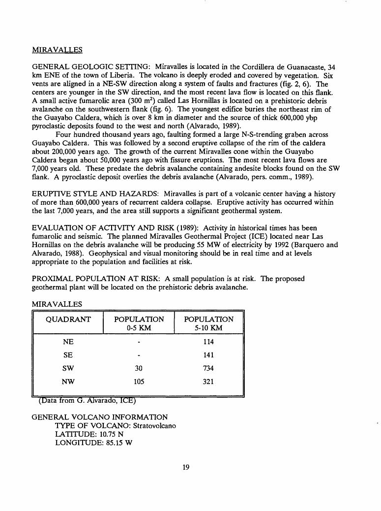
GENERAL GEOLOGIC SETTING: Miravalles is located in the Cordillera de Guanacaste, 34 km ENE of the town of Liberia. The volcano is deeply eroded and covered by vegetation. Six vents are aligned in a NE-SW direction along a system of faults and fractures (fig. 2, 6). The centers are younger in the SW direction, and the most recent lava flow is located on this flank. A small active fumarolic area (300 m2) called Las Hornillas is located on a prehistoric debris avalanche on the southwestern flank (fig. 6). The youngest edifice buries the northeast rim of the Guayabo Caldera, which is over 8 km in diameter and the source of thick 600,000 ybp pyroclastic deposits found to the west and north (Alvarado, 1989).
Four hundred thousand years ago, faulting formed a large N-S-trending graben across Guayabo Caldera. This was followed by a second eruptive collapse of the rim of the caldera about 200,000 years ago. The growth of the current Miravalles cone within the Guayabo Caldera began about 50,000 years ago with fissure eruptions. The most recent lava flows are 7,000 years old. These predate the debris avalanche containing andesite blocks found on the SW flank. A pyroclastic deposit overlies the debris avalanche (Alvarado, pers. comm., 1989).
ERUPTIVE STYLE AND HAZARDS: Miravalles is part of a volcanic center having a history of more than 600,000 years of recurrent caldera collapse. Eruptive activity has occurred within the last 7,000 years, and the area still supports a significant geothermal system.
EVALUATION OF ACTIVITY AND RISK (1989): Activity in historical times has been fumarolic and seismic. The planned Miravalles Geothermal Project (ICE) located near Las Hornillas on the debris avalanche will be producing 55 MW of electricity by 1992 (Barquero and Alvarado, 1988). Geophysical and visual monitoring should be in real time and at levels appropriate to the population and facilities at risk.
PROXIMAL POPULATION AT RISK: A small population is at risk. The proposed geothermal plant will be located on the prehistoric debris avalanche.
MIRAVALLES
QUADRANT
NE
SE
SW
NW
POPULATION 0-5 KM
-
-
30
105
POPULATION 5-10 KM
114
141
734
321
(Data from G. Alvarado, ICE)
GENERAL VOLCANO INFORMATIONTYPE OF VOLCANO: Stratovolcano LATITUDE: 10.75 N LONGITUDE: 85.15 W
19

LOCATION: Cordillera de Guanacaste, 34 km ENE of Liberia ELEVATION AT SUMMIT: 2028 m ELEVATION AT BASE: 700 m RADIUS: 4 kmESTIMATED VOLUME OF VOLCANIC EDIFICE: 120 km3 (Carr, 1984) CRATER DIAMETER: Eroded, no remnants of crater CRATER DEPTH: Not applicableESTIMATED AGE OF VOLCANO: 50,000 ybp (Alvarado, pers. comm., 1989) ROCK TYPE: Hypersthene-augite andesite to basaltic andesite (Alvarado, 1989) THERMAL MANIFESTATIONS: Fumaroles and hot springs are located SW of the
summit in an area called Las Hornillas (Alvarado, 1989). Commercial geothermal field under development.
HISTORICAL ERUPTIONS: NoneACCESS: Paved road from Bugaces to Guayabo (base of the volcano)
MONITORINGSEISMIC MONITORING: Yes
TYPE: Eight stations; telemetered since 1983 (ICE)LOCATION: 1.) 4.6 km WSW of summit (permanent); 2.) 12.5 km SW of
summit (permanent); 3.) 10.3 km SSW of summit (permanent); 4.) 5.5 km S of summit (permanent); 5.) 5.7 km NNW of summit (portable); 6.) 13 km WSW of summit (portable); 7.) 15 km SW of summit (portable); 8.) 8 km SW of summit (portable)
DURATION: Since 1977 DEFORMATION MONITORING: Yes
TYPE: EDM, 2 stations (ICE)LOCATION: No information DURATION: No information
TYPE: Trigonometric leveling (ICE) LOCATION: No information DURATION: Since 1983
TYPE: Spirit-level tilt, 4 stations (ICE)LOCATION: 1.) 3.7 km SW of summit, 2.) 4.5 km SW of summit, 3.) 6.5
km SW of summit, 4.) 7 km SW of summit DURATION: No information
TYPE: Gravity, LaCoste instrumentation (ICE, Open University, England) LOCATION: Network inside Guayabo Caldera DURATION: Since 1985
GAS AND FUMAROLE MONITORING: Yes, temperature and water chemistry ofexploration wells (ICE). Frequency of measurements is unknown.
SIGNS OF RECENT UNREST: None, the only historical activity has been fumarolic andbackground seismicity (Barquero, 1987).
GEOLOGIC MAP: Yes, detailed, 1:50,000 (Santana, 1977) HAZARD MAP: None TOPOGRAPHIC MAPS:
- Miravalles, Sheet 3148 II, 1966, U.S. Army Map Service, Washington, D.C., 1:50,000.
20

AERIAL PHOTOGRAPHS (Miravalles):
DATE SCALE ROLL NUMBER FLIGHT LINE
FRAME NUMBERS
1977 1:25,000 R114 L3 16304
1977 1:35,000 R119 - 9219-9236
1979 1:25,000 R136 - 14020-14023
GEOLOGIC WORKERS (Name, specialty, date referring to publications found in Bibliography):- Alvarado, general geology, 1989- Barquero, J., historical eruption record, unpublished- Barquero, R., monitoring, general geology, 1989a- Santana, geologic mapping, 1977
21

U.S. D
EPA
RT
ME
NT
OF T
HE
INT
ER
IOR
U
.S. GE
OL
OG
ICA
L SU
RV
EY
i u. /y
OPE
N-FIL
E R
EPO
RT
91-5
91
^ r\>\..;%^.
' V
V \
1-.i.,-
\*
Border of prehistoric
Guayabo C
aldera
PR
O V
INC
I A
DE
AL
AIJU
E
Volcan M
iravalles
! i\, -T- S
EIS
MIC
ST
AT
ION
) if
SaTIO
L
g'S
ME
SAS
3
\" /
).I'.
Las Hornillas
CO
NE
CR
AT
ER
SP
IRIT
-LEV
EL T
ILT S
TA
TIO
N
U
: '
X'/f/L
a F
ortu
ne
0
Vy
J, 1
/1 /JL,a fortu
ne
w
.^
T1
' ^
2 K
ILO
ME
TE
RS
/
"^ ~;
. '
u:"-- *--^_
_<
\'l^.
,J
! .
, .iLC
l?^:
CO
NT
OU
R IN
TE
RV
AL=
20 MFigure 6.
Topographic m
ap of Miravalles.
22T
his map is preliininary and has not b
een review
ed for conformity w
ithU
.S. Geological Survey editorial standards.
Any use of trade, firm
, or productu
TG
o*
f°rdcSCriptiV
B P
urposes only and does not imply endorsem
ent by the

TENORIO
GENERAL GEOLOGIC SETTING: Tenorio, located in the Cordillera de Guanacaste (fig. 2, 7), 10 km north of the Laguna de Arenal, has not erupted in historical times. The complex consists of 4 volcanic cones aligned in a NW-SE direction (Alvarado, 1989). The cones, from the NW to SE consist of 1) a series of domes, 2) Cerro Montezuma, which has a double crater, 3) a dissected cone whose crater is breached to the NE, and 4) Tenorio, the active cone which also has a double crater. The morphologies of both of these craters and their lava flows are well-preserved, indicative of eruptive activity in the recent past. The northwestern crater is the most recently active (Alvarado, 1989).
ERUPTIVE STYLE AND HAZARDS: Deposits of lava flows, pyroclastic surges, pyroclastic flows, and mudflows indicate a variety of eruptive styles and hazards.
EVALUATION OF ACTIVITY AND RISK (1989): There have been no overt signs of unrest; however, there are active hot springs and fumaroles on the flanks of the volcano, and the youngest features have youthful morphology. Deposits on the west flank of Tenorio are deeply weathered and covered with .5 to 1 m of well-developed soil with no obvious tephra units.
PROXIMAL POPULATION AT RISK: There is a small population located to the west and northwest of the volcano.
TENORIO
QUADRANT
NE
SE
SW
NW
POPULATION 0-5 KM
-
-
41
-
POPULATION 5-10 KM
129
36
249
543
(Datalrom GTAlvarado, ICE)
GENERAL VOLCANO INFORMATIONTYPE OF VOLCANO: StratovolcanoLATITUDE: 10.67 NLONGITUDE: 85.02 WLOCATION: Cordillera de GuanacasteELEVATION AT SUMMIT: 1916 mELEVATION AT BASE: 600 mRADIUS: 5.5 kmESTIMATED VOLUME OF VOLCANIC EDIFICE: 95 km3CRATER DIAMETER: 250 mCRATER DEPTH: 50 mESTIMATED AGE OF VOLCANO: No information
23

U.b. U
tFA
KlM
tlNl O
h IH
t INT
ER
IOR
U
.S. G
EO
LO
GIC
AL
SU
RV
EY
OPE
N-FIL
E R
EP
OR
T
91
-59
1
CO
NT
OU
R IN
TE
RV
AL^ 20 M
Figure 7. T
opographic map of T
enorio,
25T
his map is prelim
inary and has not b
een review
ed for conformity w
ith U
.S. Geological Survey editorial standards.
Any use of trade, firm
, or product nam
es is for descriptive purposes only and does not imply endorsem
ent by the U
.S. Governm
ent.

ROCK TYPE: Augite-hypersthene andesite and olivine basalt (Alvarado, 1989) THERMAL MANIFESTATIONS: Fumaroles named Los Quemados cover 2500 m2 and
are located on the northeast flank of the volcano at 965 m; hot springs named La Casa are located 1 km to the north.
HISTORICAL ERUPTIONS: NoneACCESS: Canas Road leads to Bijagua at the base of the volcano.
MONITORINGSEISMIC MONITORING: None DEFORMATION MONITORING: NoneGAS AND FUMAROLE MONITORING: Hot springs have been sampled for Ph,
temperature, sulfur, chloride, and fluoride (OVSICORI). Frequency of measurements is unknown.
SIGNS OF RECENT UNREST: None GEOLOGIC MAP: Yes, reconnaissance, 1:50,000, (ICE). There is also a reconnaissance
geomorphology study at 1:50,000 (OVSICORI). HAZARD MAP: None TOPOGRAPHIC MAPS:
- Miravalles, Sheet 3148 II, 1966, U.S. Army Map Service, Washington, D.C., 1:50,000.- Tierras Morenas, Sheet 3147 I, 1966, U.S. Army topographic Command, Washington,
D.C, 1:50:000.- Arenal, Sheet 3247 IV, 1965, Institute Geogrdfico Nacional, San Jos6, Costa Rica,
1:50,000.- Guatuso, Sheet 3248 III, 1965, Institute Geogrdfico Nacional, San Jos6, Costa Rica,
1:50,000. AERIAL PHOTOGRAPHS (Tenorio):
DATE SCALE ROLL NUMBER FLIGHT LINE
FRAME NUMBERS
1977 1:35,000 R119 - 9215-9218
GEOLOGIC WORKERS (Name, specialty, date referring to publications found in Bibliography):- Alvarado, general geology, 1989- Barquero, J., historical eruption record, unpublished- Bravo, geomorphology, 1989
24
ARENAL
GENERAL GEOLOGIC SETTING: Arenal is located at the east end of Laguna de Arenal in the Cordillera de Guanacaste. It is an active, symmetrical, small-volume cone growing 3 km northwest of the dissected remains of a smaller inactive volcanic center, Cerro Chato (fig. 2, 8). The active cone is largely composed of basaltic-andesite lava flows with subordinate tephra deposits (Melson, 1982). Arenal is thought to have begun erupting about 3000 years ago (Borgia and others, 1988), giving an average eruption rate of .01 km3/year. Until 1968, Arenal was considered inactive. But on July 29, 1968, after 10 hours of felt earthquake activity, an eruption destroyed 12 km2 of forest and formed 3 new craters on the western flank. These 3 craters and the main fumarolic area are arranged along a NW-SE fissure. Pyroclastic flows were emplaced in major drainages, killing 78 people; ash was deposited to the west. The explosive phase was followed by the extrusion of a blocky lava flow (Minakami and Utibori, 1969) which has continued during 23 years since the onset of activity. Losses have been estimated at $850,000. Older pyroclastic deposits more voluminous than those produced in 1968 are seen on the flanks.
ERUPTIVE STYLE AND HAZARDS: The 1968 eruption was characteristic of the volcano's typical eruptive style as suggested by the stratigraphic record: long periods of repose (300 ± 150 years), followed by a short, intense plinian explosive phase that produces small-volume pyroclastic flows and then grades into a largely effusive phase. At least 9 such eruptions have occurred over the past 3000 years (Borgia and others, 1988).
EVALUATION OF ACTIVITY AND RISK: The Sangregado Hydroelectric Dam, located 6.5 km WNW of the summit on the Rio Arenal, produces 60% of the electricity for Costa Rica. Tephra events and mudflows could seriously impact the dam and surrounding settlements. Very young appearing mudflows on the east flank of Arenal near the Rio Burio may indicate high potential for destruction of the downstream town of La Fortuna (pop. 3000). There also is a possibility that moderate sized debris avalanches could impact the lake and dam through collapse of part of the steep flanks. The blocky lava flow continues to be extruded accompanied by frequent explosions of gas, vapor, ash, and ballistic fragments. As long as this activity continues, risk in the near field from ballistic fragments remains high, and in 1988, one climber was killed and another was injured by such projectiles. Acid rain from the summit gas plume renders the western slopes unsuitable for agriculture. Because only small-volume pyroclastic flows and tephra deposits are known in the geologic record, voluminous pyroclastic eruptions are not anticipated (Field reconnaissance by Banks).
PROXIMAL POPULATION AT RISK: The population at risk is relatively low. The Sangregado Hydroelectric Dam, 6.5 km WNW of the summit, and the towns of La Fortuna, east of the summit in the Rio Burio valley are at risk if there is renewed intense activity.
26
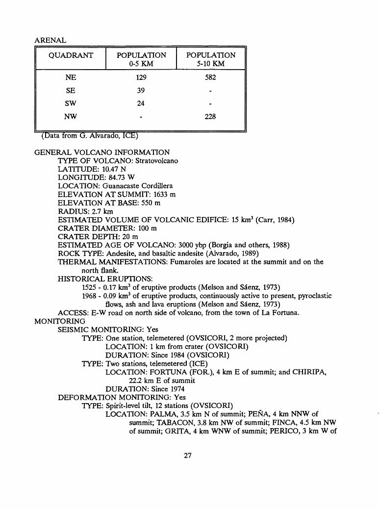
ARENAL
QUADRANT
NE
SE
SW
NW
POPULATION 0-5 KM
129
39
24
-
POPULATION 5-10 KM
582
-
-
228
(Data from G. Alvarado7TCE)
GENERAL VOLCANO INFORMATIONTYPE OF VOLCANO: StratovolcanoLATITUDE: 10.47 NLONGITUDE: 84.73 WLOCATION: Guanacaste CordilleraELEVATION AT SUMMIT: 1633 mELEVATION AT BASE: 550 mRADIUS: 2.7 kmESTIMATED VOLUME OF VOLCANIC EDIFICE: 15 km3 (Carr, 1984)CRATER DIAMETER: 100 mCRATER DEPTH: 20 mESTIMATED AGE OF VOLCANO: 3000 ybp (Borgia and others, 1988)ROCK TYPE: Andesite, and basaltic andesite (Alvarado, 1989)THERMAL MANIFESTATIONS: Fumaroles are located at the summit and on the
north flank. HISTORICAL ERUPTIONS:
1525 - 0.17 km3 of eruptive products (Melson and Sa"enz, 1973)1968 - 0.09 km3 of eruptive products, continuously active to present, pyroclastic
flows, ash and lava eruptions (Melson and Sa"enz, 1973) ACCESS: E-W road on north side of volcano, from the town of La Fortuna.
MONITORINGSEISMIC MONITORING: Yes
TYPE: One station, telemetered (OVSICORI, 2 more projected) LOCATION: 1 km from crater (OVSICORI) DURATION: Since 1984 (OVSICORI)
TYPE: Two stations, telemetered (ICE)LOCATION: FORTUNA (FOR.), 4 km E of summit; and CHIRIPA,
22.2 km E of summit DURATION: Since 1974
DEFORMATION MONITORING: YesTYPE: Spirit-level tilt, 12 stations (OVSICORI)
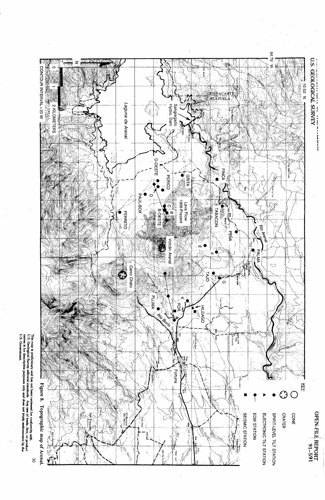
LOCATION: PALMA, 3.5 km N of summit; PENA, 4 km NNW ofsummit; TABACON, 3.8 km NW of summit; FINCA, 4.5 km NW of summit; GRITA, 4 km WNW of summit; PERICO, 3 km W of
27
summit; B-OESTE, 1.9 km W of summit; D-OESTE, 3.5 km W of summit; PAUL-BOX, 3 km SW of summit; FERRETO, 3 km SSW of summit; PLUMA, 3.25 km E of summit; TAJO, 3 km NE of summit
DURATION: Since 1982, measured every 10 weeks. TYPE: Spirit-level tilt, 9 station (ICE)
LOCATION: B, 1.8 km W of summit; C, 2.2 km WSW of summit; D, 3.3 km WSW of summit; E, 2.2 km N of summit; F, 2.8 km N of summit; G, 3.4 km NNW of summit; I, 1.8 km NE of summit; J, 2.5 km NE of summit; K, 3.2 NE of summit
DURATION: Since 1982 TYPE: Electronic tilt, 2 stations (OVSICORI)
LOCATION: near C-OESTE, 2.1 km W of summit; HIDALGO, 3.7 kmNE of summit
DURATION: Every 2 weeks since 1983 (read by hand-held meter) TYPE: EDM (OVSICORI), 2 lines, measured every 2 weeks
LOCATION: West side and east side DURATION: Since 1984
TYPE: Gravity (ICE)LOCATION: Stations are arranged in a line E and W of the volcano;
additional stations are located to the N of the summit. DURATION: No information
GAS AND FUMAROLE MONITORING: Yes 6 sites for geochemical sampling of water (OVSICORI) 9 sites for geochemical sampling of water (ICE) 6 sites for radon cups since 1981 (OVSICORI). 7 stations to measure acid rain (OVSICORI). In affiliation with Dr. J.L. Cheminee of the Centre Nationale Francais de
1'Investagation Scientifique and OVSICORI, measurements of gas, condensates, fumarole temperatures, compositions, and proportions of isotopes since 1979.
Frequency of measurements varies from 2 to 8 weeks. SIGNS OF RECENT UNREST: Eruptive activity continues since 1968. Lava flow is still being
emitted; summit explosions and light ashfalls occur frequently. GEOLOGIC MAP: Yes, Malavassi, detailed, 1:10,000, 1980 HAZARD MAP: 1:50,000, Being developed by Eduardo Malavassi, Guillermo Alvarado, and
Andrea Borgia. TOPOGRAPHIC MAPS:
- Fortuna, Sheet 3247 II, 1981, MOPT, San Jose, Costa Rica, 1:50,000.- Tilaran, Sheet 3246 IV, 1982, MOPT, San Jose, Costa Rica, 1:50,000.- Arenal, Sheet 3247 IV, 1965, Institute Geogrdfico Nacional, San Jose\ Costa Rica,
1:50,000.- Monterrey, Sheet 3247 I, 1969, U.S. Army Topographic Command, Washington, D.C.,
1:50:000.
28
U.S. G
EO
LO
GIC
AL
SUR
VE
Y10.53- N
O
OPE
N-FIL
E R
EPO
RT
!
91
-59
1
CO
NE
CR
AT
ER
SP
IRIT
-LEV
EL T
ILT S
TA
TIO
N
ELE
CT
RO
NIC
TILT
ST
AT
ION
ED
M S
TA
TIO
N
ti Ci^
'Ta
:
\ m:,« /
, G
RIT
A
jij;:^'
I av
a F
low
(T
^^
^^
K^
^.f^
^
^^|p
1968-Present
|^^
' ^J
/
PE
RIC
O ^ii C
^
CO
NT
OU
R IN
TE
RV
AL=
20 MFigure 8.
Topographic m
ap of Arenal.
30T
his map is prelim
inary and has not been
reviewed for conform
ity with
U.S. G
eological Survey editorial standards. A
ny use of trade, firm, or product
names is for descriptive purposes only and does not im
ply endorsement by the
U.S. G
overnment.

AERIAL PHOTOGRAPHS (Arenal):
DATE SCALE ROLL NUMBER FLIGHT LINE
FRAME NUMBERS
1988 1:30,000 R251 - 43753-43577
GEOLOGIC WORKERS (Name, specialty, date referring to publications found in Bibliography):- Alvarado, general geology, 1989- Barquero, J., historical eruption record, unpublished- Borgia, structure, stratigraphy, petrology, 1983, 1988- Carr, physical and geochemical characteristics, 1984- Casadevall, plume geochemistry, 1984- Corrado, lava flow dynamics, 1984- Fudali, eruption dynamics, 1977- Malavassi, geology, petrology, 1979, 1982- Melson, geology, geochemistry, eruption cycles, radiocarbon dates, 1973, 1982, 1984,
1986; on-going eruption monitoring- Minakami, geology, eruption chronology, 1969- Reagan, geochemistry, 1987- Stoiber, tectonics, 1973- Wadge, eruption rates, 1982a, 1983
29
PLATANAR
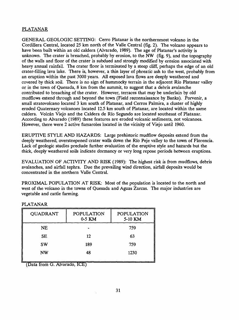
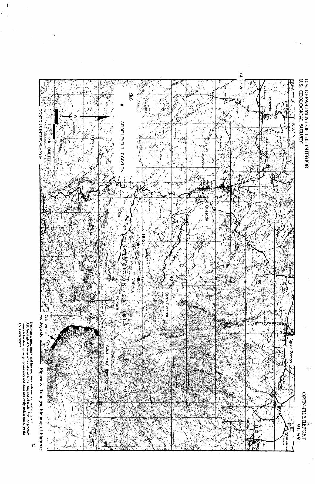
GENERAL GEOLOGIC SETTING: Cerro Platanar is the northernmost volcano in the Cordillera Central, located 25 km north of the Valle Central (fig. 2). The volcano appears to have been built within an old caldera (Alvarado, 1989). The age of Platanar's activity is unknown. The crater is breached, probably by erosion, to the NW (fig. 9), and the topography of the walls and floor of the crater is subdued and strongly modified by erosion associated with heavy annual rainfall. The crater floor is terminated by a steep cliff, perhaps the edge of an old crater-filling lava lake. There is, however, a thin layer of phreatic ash to the west, probably from an eruption within the past 3000 years. All exposed lava flows are deeply weathered and covered by thick soil. There is no sign of hummocky terrain in the adjacent Rio Platanar valley or in the town of Quesada, 8 km from the summit, to suggest that a debris avalanche contributed to breaching of the crater. However, terraces that may be underlain by old mudflows extend through and beyond the town (Field reconnaissance by Banks). Porvenir, a small stratovolcano located 3 km south of Platanar, and Cerros Palmira, a cluster of highly eroded Quaternary volcanoes located 12.5 km south of Platanar, are located within the same caldera. Volcdn Viejo and the Caldera de Rio Segundo are located southeast of Platanar. According to Alvarado (1989) these features are eroded volcanic sediments, not volcanoes. However, there were 2 active fumaroles located in the vicinity of Viejo until 1960.
ERUPTIVE STYLE AND HAZARDS: Large prehistoric mudflow deposits extend from the deeply weathered, oversteepened crater walls down the Rio Peje valley to the town of Florencia. Lack of geologic studies preclude further evaluation of the eruptive style and hazards but the thick, deeply weathered soils indicate dormancy or very long repose periods between eruptions.
EVALUATION OF ACTIVITY AND RISK (1989): The highest risk is from mudflows, debris avalanches, and airfall tephra. Due the prevailing wind direction, airfall deposits would be concentrated in the northern Valle Central.
PROXIMAL POPULATION AT RISK: Most of the population is located to the north and west of the volcano in the towns of Quesada and Aguas Zarcas. The major industries are vegetable and cattle farming.
PLATANAR
QUADRANT
NE
SE
SW
NW
POPULATION 0-5 KM
-
12
189
48
POPULATION 5-10 KM
759
63
759
1230
(Data from G. AlvaradoT ICE)
31

GENERAL VOLCANO INFORMATIONTYPE OF VOLCANO: StratovolcanoLATITUDE: 10.30 NLONGITUDE: 84.37 WLOCATION: Cordillera CentralELEVATION AT SUMMIT: 2183 mELEVATION AT BASE: 1000 mRADIUS: 5.5 kmESTIMATED VOLUME OF VOLCANIC EDIFICE: 50 km3 (Carr, 1984)CRATER DIAMETER: (deeply eroded) Approximately 500 mCRATER DEPTH: Not applicableESTIMATED AGE OF VOLCANO: UnknownROCK TYPE: Pyroxene andesite (Alvarado, 1989)THERMAL MANIFESTATIONS: NoneHISTORICAL ERUPTIONS: NoneACCESS: Follow Road #140 from Quesada to the NE. There are several unimproved
roads from the southeast that lead up to 1440 m. MONITORING
SEISMIC MONITORING: YesTYPE: One station, telemetered (OVSICORI)
LOCATION: No information DURATION: No information
DEFORMATION MONITORING: YesTYPE: Spirit-level tilt, 2 stations (OVSICORI)
LOCATION: HUGO, 4 km SW of the summit; VARELA, 2 km SW ofsummit
DURATION: Since May, 1982, every 24 weeks. No changes have beenobserved.
GAS AND FUMAROLE MONITORING: None SIGNS OF RECENT UNREST: Yes, there was felt seismicity in 1980, which was confirmed
with a temporary seismic net (Guendel, pers. comm.). GEOLOGIC MAP: Yes, 1:50,000, reconnaissance, by Guillermo Alvarado HAZARD MAP: None TOPOGRAPHIC MAPS:
- Aguas Zarcas, Sheet 3347 III, 1970, U.S. Army Topographic Command, Washington, D.C., 1:50:000.
- Quesada, Sheet 3346 IV, 1970, U.S. Army Topographic Command, Washington, D.C,1:50:000.
AERIAL PHOTOGRAPHS (Platanar):
DATE SCALE ROLL NUMBER FLIGHT LINE
FRAME NUMBERS
1961 1:25,000 R143 - 6636-6639
1977 1:35,000 R019 L3A 713-764
32
GEOLOGIC WORKERS (Name, specialty, date referring to publications found in Bibliography):- Alvarado, general geology, 1989- Barquero, J., historical eruption record, unpublished- Paniagua and Soto, volcanic hazards, 1988
33
U.b. U
tWV
KI M
tNT
OF T
HE
INT
ER
IOR
U
.S. GE
OL
OG
ICA
L SU
RV
EY
* 10.38" N
OPE
N-FIL
E R
EPO
RT
9
1-5
91
84.5
0' W
1
SP
IRIT
-LEV
EL T
ILT S
TA
TIO
N
^,^- \
0 ;%
1 ^
2 KILO
ME
TE
RS
CO
NT
OU
R IN
TE
RV
AL=
20 MF
igure 9. T
opographic map of P
latan ar.
This m
ap is preliminary and has not been review
ed for conformity w
ith U
.S. Geological S
urvey editorial standards. A
ny use of trade, firm, o
r product nam
es is for descriptive purposes only and does not imply endorsem
ent by the U
.S. Governm
ent.
34
POAS (also referred to as Los Botos)
GENERAL GEOLOGIC SETTING: Pods is located at the northern margin of the Valle Central, 20.5 km north of the town of Alajuela. It is a large basaltic-andesite composite volcano with a rounded dome-like shape and gently sloping flanks (fig. 2, 10). Two poorly preserved nested calderas with diameters of 12 and 8 km are recognized by Mooser and others (1958). All historical activity has been phreatic and phreatomagmatic and has taken place within the inner caldera which formed > 40,000 years ago. Several other features have developed since the calderas formed. Aligned from north to south are 1) the Von Frantzius Cone, an eroded composite cone with a crater breached to the south, 2) the Main Crater, a .8 km diameter collapse crater which contains the hot, acid Laguna Caliente, and 3) the Botos Cone, a cone smaller and younger than the Von Frantzius Cone which contains Laguna Del Poas, a cold freshwater lake (Prosser and Carr, 1987).
High annual rainfall has contributed to the deep weathering and erosion of the north slope of the volcanic edifice, and deposits on all the flanks are very deeply weathered, with no intermixed tephra in the 1- to 2-m-thick soil.
Volcdn Congo and a series of lake-filled maars and small calderas, the largest of which is Laguna Hule lie on the lower northern flanks of the Pods complex, generally in alignment with the NNE-aligned craters and cones on Pods' summit (Alvarado, 1989). These maars and small calderas have youthful morphology and Melson (1988) reports a radiocarbon age of 5,140 ±110 ybp for a pyroclastic-flow deposit from Volcdn Congo. Similarly youthful features are not apparent on the southern flanks of Pods.
ERUPTIVE STYLE AND HAZARDS: A study by Prosser (1987) of recent summit lava flows defines three intermediate to mafic compositional cycles, each lasting from 1,000 to 10,000 years. Prosser observed that a new, intermediate lava sequence is associated with a change in location or structure of the active vent. Mafic lava compositions (50% SiO2) signal the end of an eruptive cycle. An analysis of these trends indicates repeated fractionation of a slowly cooling magma chamber deep in the crust. The present cycle was initiated > 7,540 years ago. Less than 7,000,000 m3 of volcanic material has been produced in historical times.
Four types of activity have been observed historically at Pods: 1) phreatic geyser-like explosions at variable intervals, 2) violent, but small volume, phreatic eruptions that produce ash that falls as far as the Valle Central, 3) strombolian and effusive activity, and 4) quiet degassing (Prosser, 1983). In the Main Crater, the site of all historical activity, pyroclastic deposits are about twice as abundant as lava flows (Prosser, 1986).
Rymer and Brown (1987) have suggested that microgravity variations measured at Pods since 1983 indicate subsurface density changes have occurred. They conclude that the fluctuations in volume of gas in the underlying magma, a process driven by thermal convection cycles, can account for these changes.
EVALUATION OF ACTIVITY AND RISK: Pods has been frequently active since first explored by the Spanish in 1747. Eruptions have consisted of small phreatic and strombolian events and have deposited mud, ash, and pumice to a distance of 12 km (Walker, 1982). In 1971, the summit was made into a national park, which receives over 60,000 visitors per year. There is a high probability for small, infrequent phreatic and strombolian eruptions that create moderate to high hazards to visitors to the park in the summit area. However, the park is closed immediately following any signs of increased activity. Probability for a large eruption is low; also probability of large mass failures of the flanks is moderate on the N and E slopes, but
35

low on the SW slopes (Field reconnaissance by Banks).Distribution of tephra-fall deposits is controlled by the prevailing low-level northeasterly
winds. As a result, deposits of future eruptions would most likely affect the southwestern flanks. Gas, acid rain, and acid leachate from ash and tephra have seriously impacted the local economy by damaging or destroying cash crops during past eruptions. Commercial coffee, sugar cane, fruit, and vegetable farms share the flanks of the volcano with livestock farms, all of which could suffer heavy losses through contamination of forage and water supplies.
The start of the last episode of activity began with increased gas temperature and seismic swarms in January 1981 and has continued through 1991. In June 1987, lake acidity increased by a factor of 4. Several 200- to 300-m-high, geyser-like eruptions occurred in March and April 1988. The crater lake disappeared in April 1989 and explosive activity deposited traces of lake sediments and lithic ash up to 20 km west of the summit (Guendel, pers. comm., 1989). Acid rain affected the economy and the health of the population located as far as 11 km from the summit on the NW flank of the volcano. Coffee plants and other vegetation died. In addition, many people are suffering from respiratory problems (Barquero, SEAN, 1989).
PROXIMAL POPULATION AT RISK: The summit area is a national park and receives 60,000 visitors a year (Prosser, 1983). Additionally, the southern and western flanks are populated with farms producing sugar cane, coffee, dairy products, strawberries, and commercial flowers.
POAS
QUADRANT POPUL 0-5
NE
SE
SW
NW
ATION POPULATION KM 5-10 KM
291
810
780
264
(Data from G. Alvarado, ICE)
GENERAL VOLCANO INFORMATIONTYPE OF VOLCANO: StratovolcanoLATITUDE: 10.20 NLONGITUDE: 84.22 WLOCATION: Central Cordillera, 35 km NW of San Jos6ELEVATION AT SUMMIT: 2704 mELEVATION AT BASE: 1200 mRADIUS: 8.7 kmESTIMATED VOLUME OF VOLCANIC EDIFICE: 95 km3 (Carr, 1984)CRATER DIAMETER: 1.5 kmCRATER DEPTH: 275 mESTIMATED AGE OF VOLCANO: > 1 my (Sdenz, 1982)ROCK TYPE: Andesite, basaltic andesite (Alvarado, 1989)
36

THERMAL MANIFESTATIONS: Fumaroles and a hot lake located in the Main Crater. HISTORICAL ERUPTIONS:
1834 - Ash as far as 40 km to the southwest (Boza and Mendoza, 1981)1838 - Eruption uncertain (Mooser and others, 1958)1880 - Phreatic explosions (Mooser and others, 1958)1907 - Phreatic explosions (Mooser and others, 1958)1910 - Phreatomagmatic eruption, 8-km-high eruption cloud, ashfall in San Jose
33 km to the SW (Casertano and others, 1985)1914 - Phreatic explosions (Mooser and others, 1958)1914 - Phreatic explosions (Mooser and others, 1958)1946 - Phreatic explosions (Hantke, 1951)1952 - Phreatic explosions, the plume reached 7 km in altitude and ashfall was
reported 15 km away (Barquero and Malavassi, 1982)1961 - No details (Bull, of Volcanic Eruptions, 1964)1963 - No details ((Bull, of Volcanic Eruptions, 1965))1964 - Steam and ash eruptions (Krushensky and Escalante, 1967)1967 - No details (Bull, of Volcanic Eruptions, 1972)1969 - Phreatic explosions (Bull, of Volcanic Eruptions, 1972)1972 - Explosions through crater lake (Bull, of Volcanic Eruptions, 1974, 1975)1974 - Phreatic explosions (Bull, of Volcanic Eruptions, 1976, 1977)1976 - Explosions through crater lake (Simkin and others, 1981)1977 - A column of water, ash, and mud rose more than 1 km above the vent
(McClelland and others, 1989)1978 - explosions, gas emissions (McClelland and others, 1989)1979 - Phreatic activity (McClelland and others, 1989)1980 - Continuous phreatic activity (McClelland and others, 1989)1987 - Phreatic activity (Barquero, pers. comm.)1988 - Phreatic activity (Barquero, pers. comm.)1989 - Phreatic activity (Barquero, pers. comm.) 1991 - Phreatic activity (Barquero, pers. comm.)
ACCESS: Paved road to the summit from the south MONITORING
SEISMIC MONITORING: YesTYPE: One station, telemetered (OVSICORI)
LOCATION: POA2, 2 km SW of summit DURATION: Since 1984
TYPE: Five stations (ICE)LOCATION: No information DURATION: Since 1991
TYPE: One station (UCR)LOCATION: In park museum DURATION: No information
DEFORMATION MONITORING: YesTYPE: Spirit-level tilt, 11 active stations (OVSICORI). No significant changes
were detected during 1982-1987 nor during the phreatic activity of 1987- 1988.LOCATION: PICNIC, 200 m S of crater rim on the road; LANCE, 2 km
SW of summit; SANTA ROSA, 10 km SW of summit; SAN JUAN
37
NORTE, 8 km SSW of summit; GUIDO, 9.5 km SSE of summit; SABANA REDONDA, 8 km SE of summit; OMAR, 4 km SE of summit; FLORY, 4.7 km SE of summit; HROL-3, 5.1 km SE of summit; TERRANOVA, 5.8 km SE of summit; LA PAZ, 6.1 km SE of summit;
DURATION: Since 1982, measured every 10 weeks TYPE: EDM, 1 line (OVSICORI)
LOCATION: Across craterDURATION: Since 1984, measured every 10 weeks. No changes were
detected from 1984 through 1987; slight line shortening was reported before the 1987-1988 phreatic activity.
TYPE: Electronic tilt, 2 stations (OVSICORI)LOCATION: GUIDO, 9.5 km SSE of summit; PICNIC, 200 m south of
the crater rim on the road. No changes larger than noise (10 urads) observed over period of measurements.
DURATION: Since 1984, measured every 2 weeks (read by hand-heldmeter)
TYPE: LevelingLOCATION: 1) 15 km first order line from San Pedro to summit in 1974
and 1982 (no change) (OVSICORI); 2) 15 km 12 station trigonometric level line (French, March 1982); 3) 18 km radial line measured every 3 years (OVSICORI)
DURATION: Measured in 1982 and 1988 TYPE: Gravity, 18 stations, Rymer and Brown, of the Open University, Milton
Keyes, U.K., cyclic variations spanning a 140 uGal amplitude change.LOCATION: Net spans the Main Crater and crater rimDURATION: Since 1983
TYPE: Crack measurement (OVSICORI)LOCATION: No informationDURATION: No information
GAS AND FUMAROLE MONITORING: Yes Measurements of fumarole gas (sulfur, chloride, and fluoride) and
temperature measurements at the summit every 4 weeks (OVSICORI, ICE)
Measurements of the lake water: Ph, temperature, sulfur, chlorine, and fluorine (OVSICORI, ICE)
9 sites, radon cups measured every 2 weeks (OVSICORI) 7 site acid rain network measured every 2 weeks (OVSICORI)
SIGNS OF RECENT UNREST: Yes, increased lake temperature, fumarolic activity, acid rain,microgravity changes since 1985, currently in eruption.
GEOLOGIC MAP: Yes, Prosser (1983), unpublished M.S. thesis, 1:4,500. There is also adetailed 1:4,500 geomorphology map by OVSICORI.
HAZARD MAP: Yes, reconnaissance, 1:50,000 maps by both OVSICORI and GuillermoAlvarado, Gerardo Soto, and Sergio Paniagua of ICE.
TOPOGRAPHIC MAPS:- Poas, Sheet 3346 I, 1970, U.S. Army Topographic Command, Washington, D.C.,
1:50:000.- Barba, Sheet 3346 II, 1965, U.S. Army Map Service, Washington D.C., 1:50,000.
38

- Quesada, Sheet 3346 IV, 1970, U.S. Army Topographic Command, Washington, D.C., 1:50:000.
- Naranjo, Sheet 3346 III, 1980, Institute Geograiico Nacional, San Jos6, Costa Rica,1:50,000.
AERIAL PHOTOGRAPHS (Po£s):
DATE SCALE ROLL NUMBER FLIGHT LINE
FRAME NUMBERS
1988 1:30,000 R250 - 43211-43215
GEOLOGIC WORKERS (Name, specialty, date referring to publications found in Bibliography):- Alvarado, general geology, 1989- Barquero, J., historical eruption record, unpublished- Brantley, lake chemistry, 1987- Casadevall, plume geochemistry, 1984- Casertano, magnetics, seismology, 1982, 1985, 1987- Ferndndez, geochemistry, unpublished- Krushensky and Escalante, geologic mapping, 1967- Paniagua and Soto, volcanic hazards, 1988- Prosser, geologic mapping, 1983- Rymer and Brown, microgravity, 1987
39

U.S. G
EO
LO
GIC
AL
SUR
VE
Y
KE
Y:^
C
ON
E
CR
ATE
R
OPE
N-FIL
E R
EPO
RT
91-591
SP
IRIT
-LEV
EL T
ILT S
TA
TIO
N
LEV
ELIN
G LIN
E
ELE
CT
RO
NIC
TILT
ST
AT
ION
^W
^H
^F
30*
Von F
rantzius Cone
w^ >
Laguna del P
oas y^
Volcan C
ongo. >,.">£ .
i ,-=
-, . 1
Laguna Caliente
JUA
N N
OR
TE
2 KILO
ME
TE
RS
CO
NT
OU
R IN
TE
RV
AL=
20 MF
igure 10. T
opographic map of Pods.
40T
his map is prelim
inary and has not been
reviewed for conform
ity with
U.S. G
eological Survey editorial standards. A
ny use of trade, firm, or product
names is for descriptive purposes only and d
oes not imply endorsem
ent by the U
.S. Governm
ent.

BARVA (also spelled Barba)
GENERAL GEOLOGIC SETTING: Barva, located at the northern margin of the Valle Central 20 km north of San Jose, is a large composite volcano with many vents and parasitic cones (fig. 2, 11). A crater lake occupies one of the old vents. Basaltic-andesite lava flows alternate with thick pyroclastic beds. All deposits on the flanks are very deeply weathered, with tephra intermixed in the 1-2 m thick soil. However, overall weathering appears to be less than is the case for Po£s. Thick pyroclastic-flow deposits occur on the western slopes (Field reconnaissance by Banks). Cerro Guarari, located 3.4 km from the summit of Barva, is the erosional remnant of an ancient cone (Alvarado, 1989). Cacho Negro, 9 km NNW of Barva, is the site of thermal springs. A cluster of ancient cones, Cerros Zurqui, is located 11 km SE of Barva (Alvarado, 1989).
ERUPTIVE STYLE AND HAZARDS: The stratigraphic record reveals large explosive eruptions have produced pyroclastic flows at Barva in prehistoric times. However, there are very few geological data available for evaluating Barva.
EVALUATION OF ACTIVITY AND RISK (1989): Barva has been quiet since colonial times, and there have been no indications of seismic or thermal activity. However, the probability of mudflows and mass failures of the flanks, with or without an eruption, is moderate on the east slopes, and lower on the west slopes (Field reconnaissance by Banks). Should an eruption occur, the long repose period and past history of dome formation and pyroclastic flows would elevate Barva to a high hazard status. Tephra dispersal would be dominantly controlled by the prevailing low-level northeast winds (depositing ash on the southwest flanks).
PROXIMAL POPULATION AT RISK: The southern and western flanks are moderately populated. The local economy is dominated by sugar cane, coffee, and dairy farms.
BARVA
QUADRANT
NE
SE
SW
NW
POPULATION 0-5 KM
15
54
138
93
POPULATION 5-10 KM
-
282
2067
561
(Data from G. Alvarado, ICE)
GENERAL VOLCANO INFORMATIONTYPE OF VOLCANO: StratovolcanoLATITUDE: 10.13 NLONGITUDE: 84.08 WLOCATION: Central Cordillera, 23 km N of San Jos6ELEVATION AT SUMMIT: 2894 m
41

U.S. D
EPA
RT
ME
NT
OF T
HE
INT
ER
IOR
U
.S. GE
OL
OG
ICA
L SU
RV
EY
OPE
N-FIL
E R
EPO
RT
91-591
10.16' N
CO
NT
OU
R IN
TE
RV
AL=
20 MFigure 11.
Topographic m
ap of Barva.43
This m
ap is preliminary and has not b
een review
ed for conformity w
ith U
.S. Geological Survey editorial standards.
Any u
se of trade, firm, or product
names is for descriptive purposes only and does not im
ply endorsement by the
U.S. G
overnment.

ELEVATION AT BASE: 1500 mRADIUS: 8.3 kmESTIMATED VOLUME OF VOLCANIC EDIFICE: 255 km3 (Carr, 1984)CRATER DIAMETER: .8 kmCRATER DEPTH: No informationESTIMATED AGE OF VOLCANO: 1 million ybp (Alvarado, 1989)ROCK TYPE: Basalt to andesiteTHERMAL MANIFESTATIONS: Hot springs are located 4 km north of the summit.HISTORICAL ERUPTIONS:
1770 or 1776 - Explosions (?) and mudflow in the Rio Itiquis valley (Von Frantzius, 1981)
ACCESS: There is a road from the south to 2300 m. MONITORING
SEISMIC MONITORING: NoneDEFORMATION MONITORING: NoneGAS AND FUMAROLE MONITORING: NoneSIGNS OF RECENT UNREST? No
GEOLOGIC MAP: Yes, reconnaissance, 1:50,000 by Sergio Paniagua and Gerardo Soto. HAZARD MAP: Yes, reconnaissance, 1:50,000, by Sergio Paniagua and Gerardo Soto. TOPOGRAPHIC MAPS:
- Barba, Sheet 3346 II, 1965, U.S. Army Map Service, Washington D.C., 1:50,000. AERIAL PHOTOGRAPHS (Barva):
DATE
1977
SCALE
1:35,000
ROLL NUMBER
R003
FLIGHT LINE
L13
FRAME NUMBERS
27-31
GEOLOGIC WORKERS (Name, specialty, date referring to publications found in Bibliography):- Alvarado, general geology, 1969- Barquero, J., historical eruption record, unpublished- Paniagua and Soto, volcanic hazards, 1988
42

IRAZU (also referred to as Volcdn de Cartage)
GENERAL GEOLOGIC SETTING: Irazu is the highest volcano in Costa Rica and is one of the most active. It forms part of the northern margin of the Valle Central 24 km due east of San Jose. The volcanic edifice is composed of interbedded deposits of ashfall, pyroclastic flows, mudflows, and lava flows produced at the central crater and at flank vents (fig. 2, 12). An old crater, Diego de la Haya, is located .5 km to the east of the present active crater. According to Sapper (1925) Diego de la Haya was the site of the 1723 eruption. Active fumaroles occur in the main crater and to the NW of the crater. Steep erosional escarpments are present north of the volcano. Cerro Alto Grande, located 4 km NE of the main crater, is an eroded stratovolcano. Cerros Noche Buena, Pasqui, Cabeza de Vaca, Retes, and Guardian are cinder cones on the south flank of Irazu (Alvarado, 1989).
ERUPTIVE STYLE AND HAZARDS: Only pyroclastic ejecta was produced during the 4 major historical eruptive periods (1723, 1726, 1917-21, and 1963-65). Very little of the ejecta was juvenile (Krushensky and Escalante, 1967). Ashfall is thick on the western and northwestern flanks of the volcano. The most recent lava flow occurred approximately 13,500 to 14,000 ybp (Murata and others, 1966). Mudflows and airfall are the greatest hazards.
EVALUATION OF ACTIVITY AND RISK (1989): The 1963-65 phreatic eruptions deposited ash and defoliated 95% of the upper drainages originating on the slopes of the volcano (Krushensky, 1972). The eruptive activity for nearly 2 years produced heavy ashfall that extended as far as the city of San Jose, 24 km west of the volcano (Murata and others, 1966). These deposits contaminated water supplies and impeded air and surface transportation. Dairy and tobacco farms, coffee plantations, and citrus orchards were severely affected. The surface of ash formed a thin impermeable crust that reduced the infiltration capacity of the soil. Runoff increased causing flash floods that incorporated ash and rock debris downstream (Waldron, 1967). Rain mobilized the ash and debris to generate secondary mudflows that swept down the Rio Chiquito, killing 20 people and destroying many structures. Debris flows and erosion were also severe in the Rio Reventado valley on the southwest slope where as many as 46 mudflows occurred during a 2-year period, one of which caused the death of at least 20 people and destroyed 400 houses and some factories (Krushensky, 1972). Loss of life was minimized through prior evacuation and river watches. The Rio Tiribi, Rio Durazna, and Rio Virrilla drainages were similarly impacted but to a lesser degree.
PROXIMAL POPULATION AT RISK: The cone itself has been designated a national park. The park receives visitors throughout the year but remains in close contact with monitoring groups. In addition, the area south of the volcano in the Valle Central is moderately populated, and in the far field along the rivers draining the volcano, the population is dense. The western suburbs of Cartago on the Rio Reventado are at high risk from flooding and mudflows.
44
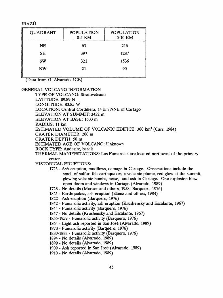
IRAZtJ
QUADRANT
NE
SE
SW
NW
POPULATION 0-5 KM
63
397
321
21
POPULATION5-10 KM
216
1287
1536
90
(Data from G. Alvarado, ICE)
GENERAL VOLCANO INFORMATIONTYPE OF VOLCANO: StratovolcanoLATITUDE: 09.89 NLONGITUDE: 83.85 WLOCATION: Central Cordillera, 14 km NNE of CartagoELEVATION AT SUMMIT: 3432 mELEVATION AT BASE: 1600 mRADIUS: 11 kmESTIMATED VOLUME OF VOLCANIC EDIFICE: 300 km3 (Carr, 1984)CRATER DIAMETER: 200 mCRATER DEPTH: 50 mESTIMATED AGE OF VOLCANO: UnknownROCK TYPE: Andesite, basaltTHERMAL MANIFESTATIONS: Las Fumarolas are located northwest of the primary
crater. HISTORICAL ERUPTIONS:
1723 - Ash eruption, mudflows, damage in Cartago. Observations include thesmell of sulfur, felt earthquakes, a volcanic plume, red glow at the summit, glowing volcanic bombs, noise, and ash in Cartago. One explosion blew open doors and windows in Cartago (Alvarado, 1989)
1726 - No details (Mooser and others, 1958; Barquero, 1976)1821 - Earthquakes, ash eruption (Sa"enz and others, 1984)1822 - Ash eruption (Barquero, 1976)1842 - Fumarolic activity, ash eruption (Krushensky and Escalante, 1967)1844 - Fumarolic activity (Barquero, 1976)1847 - No details (Krushensky and Escalante, 1967)1855-1959 - Fumarolic activity (Barquero, 1976)1864 - Light ash reported in San Jose" (Alvarado, 1989)1870 - Fumarolic activity (Barquero, 1976)1880-1888 - Fumarolic activity (Barquero, 1976)1894 - No details (Alvarado, 1989)1899 - No details (Alvarado, 1989)1909 - Ash reported in San Jose" (Alvarado, 1989)1910 - No details (Alvarado, 1989)
45

1917-1924 - Phreatic eruption with dome extrusion, ash deposited as far as theGulf of Nicoya (Alvarado, 1989)
1928-1930 - Ash eruptions (Barquero, 1976) 1933 - Ash reported in San Jos6 (Alvarado, 1989) 1939-1940 - Ash eruption (Barquero, 1976) 1953 - Fumarolic activity (Barquero, 1976) 1962 - Fumarolic activity (Barquero, 1976) 1963-1965 - Ash fell for several days in San Jos6; rain mobilized ash created
destructive mudflows (Murata and others, 1966) 1966-1978 - Fumarolic activity in the crater (Barquero, 1976) 1979-1989 - Fumarolic activity on the NW flank and elevated seismicity
(Alvarado, 1989) ACCESS: There is a road from Cartage north to the summit.
MONITORINGSEISMIC MONITORING: Yes
TYPE: One station, telemetered (OVSICORI) LOCATION: 3.5 km from crater DURATION: Since 1983
TYPE: One station, telemetered (ICE) LOCATION: 1 km from crater DURATION: since 1980
DEFORMATION MONITORING: YesTYPE: Spirit-level tilt, 10 stations (OVSICORI)
LOCATION: SAN GERARDO, 2.5 km NNE of the summit; LIEBRES, 3.5 km E of the summit; CASITA, 2 km E of the summit; PLAYA HERMOSA, .5 km S of the summit; TORRES, 1.7 km SW of the summit; GUARDIAN, 3.5 km S of the summit; PASQUI, 10.75 km S of the summit; MIRADOR, 6.75 km S of the summit; POTRERO CERRADO, 8 km SSW of the summit; TTTORAL, 8.25 km SSE of the summit
DURATION: Since May, 1982, every 10 weeks. There has been nochange since installation.
TYPE: Electronic tilt, 2 single axis (radial) Sperry tiltmeters (read by hand-held meter) (OVSICORI). LOCATION: 1) PLAYA HERMOSA, poor data was obtained for
1982-1984, station has been moved to new site on 1.7 km SW of the summit named TORRES. There have been no changes since installation. 2) CASETA, installed in Jan 1986, is located at the guard house at Park Entrance 2 km ESE of the summit. There have been no changes since installation.
DURATION: Measured every 2 weeks since 1982 TYPE: EDM, 2 lines
LOCATION: One line crosses crater; no information on second line. DURATION: Since 1984, measured every 2 years
TYPE: Leveling, first order, San Jos6 to the summit, by the Institute Geogrdfico Nacional de Costa Rica LOCATION: No information
46
DURATION: in 1949, 1961, 1964, 1966, 1982 and every 3 yearsthereafter; only small changes recorded.
TYPE: Gravity (Ken Hudmut, Dartmouth) and short leveling line radial to 1963 crater. Lamont-Doherty conducts current gravity measurements. LOCATION: No information DURATION: Every 3 years
GAS AND FUMAROLE MONITORING: Yes Fumarole gas and temperature measurements at the summit taken once yearly
(OVSICORI). 5 sites, radon cups measures every 2 weeks (OVSICORI) Intermittent measurements of lake water Ph, temperature, sulfur, chlorine, and
fluorine. SIGNS OF RECENT UNREST: Yes, increased fumarolic activity sustained since 1982, seismic
swarm in June 1982.GEOLOGIC MAP: Yes, reconnaissance, 1:50,000 by Krushensky, R. (1972). HAZARD MAP: Yes, reconnaissance, 1:50,000 by Paniagua and Soto (1986) and Alvarado
(1987). TOPOGRAPHIC MAPS:
- Cartago (Istaru), Sheet 3445 IV, 1968, U.S. Army Map Service, Washington D.C.,1:50,000.
AERIAL PHOTOGRAPHS (Irazu):
DATE SCALE ROLL NUMBER FLIGHT LINE
FRAME NUMBERS
1978 1:35,000 R133 L219 13140-13148
GEOLOGIC WORKERS (Name, specialty, date referring to publications found in Bibliography):- Alvarado, general geology, 1989- Barquero, J., historical eruption record, unpublished- Hudnut, geology and geophysics, 1983- Krushensky, geologic mapping, 1973- Mora, volcanic hazards, 1987- Murata, geology, eruption chronology, 1966- Paniagua and Soto, volcanic hazards, 1988
47

Figure 12. Topographic map of Irazu at scale 1:50,000. Filled circles indicate spirit-level tilt stations; open circles indicate electronic tilt stations; x indicates a seismic station.
48

U.S. D
EPA
RT
ME
NT
OF T
HE
INT
ER
IOR
U
.S. GEO
LOG
ICA
L SUR
VEY
OPE
N-FIL
E R
EPO
RT
91-591
CO
NE
CR
AT
ER
SP
IRIT
-LEV
EL T
ILT S
TA
TIO
N
ELE
CT
RO
NIC
TILT
ST
AT
ION
SA
N G
ER
AR
DO
o^rv
^ir
Volc^n IrazO
(-~T \ -"^>
JT" Diego de la H
aya
Active C
rater
PLA
YA
HE
RM
OS
AC
erro Cabeza de V
acaR
fo Durazna
Cerro N
oche Buena^V
W
5^
/ u- -
>S
i- ST
. ^'s
-n^
^ Cerro G
uardian
'^JW
.yV
K/'.W
Cerro P
asqul
CO
NT
OU
R II^T
ER
VA
L=20 M
^Figure 12.
Topographic m
ap of Irazii.
tT
^^^^^n
t^la
teo
riH
n*,*
*
48CX

U.S. G
EO
LO
GIC
AL
SUR
VEY
m 9.93* N
OPE
N-FIL
E R
EPO
RT
91-591
. V
^U
^fe
T^
CO
NE
CR
ATE
R
SP
IRIT
-LEV
EL T
ILT S
TA
TIO
N
ELE
CT
RO
NIC
TILT
ST
AT
ION
jti%&
i A
ctive Crater *P
LAY
A H
ER
MO
SA
Cerro N
oche Buena
< ^
x
Cerro G
uardian ^\9fer<&
PO
TR
ER
O C
ER
RA
DO
KILO
ME
TE
RS
CO
NT
OU
R IN
TE
RV
AL=
20 M
;Figure 12.
Topographic m
ap of Irazii.
48T
his map is prelim
inary and has not been reviewed for conform
ity with
U.S. G
eological Survey editorial standards. A
ny use of trade, firm, or product
names is for descriptive purposes only and does not im
ply endorsement by the
U.S. G
overnment.

TURRIALBA
GENERAL GEOLOGIC SETTING: Turrialba is the southeasternmost active volcano in Costa Rica. It forms part of the northeastern margin of the Valle Central and is located 15 km north of the towns of Juan Vinas and Turrialba (fig. 2). The current cone, with three well defined craters within a collapsed caldera, is built on a cluster of deeply eroded older volcanic edifices (fig. 13). The central crater is breached to the NE, probably the result of headward erosion, debris avalanches, and mudflows (Reagan, 1987). There are relatively recent lava flows on the northeast flank located between the Rio Elia and Rio Guacimo.
ERUPTIVE STYLE AND HAZARDS: Turrialba has erupted explosively 4 times in the last 2,000 years and currently supports solfataras. The most recent eruption occurred in 1864. Tephra-fall, pyroclastic flows, and mudflows accompanied all eruptions. One prehistoric lava flow on the NE flank extends 19 km from its vent. The rocks range in composition from basaltic andesite through dacite. Thicknesses and maturity of successive soils suggest that the repose periods are becoming progressively shorter (Reagan, 1987). The most recent eruption, in 1864- 66, which deposited ash as far as San Jose, was preceded by several years of increased fumarolic activity and emission of sulfurous gas that destroyed vegetation northwest of the cone. Reagan (1987) also lists occurrences of significant magmatic eruptions about 8,250, 2,000, and 1,040 years ago, possibly after a hiatus that may have been longer than 60,000 years.
EVALUATION OF ACTIVITY AND RISK (1989): Turrialba is currently exhibiting fumarolic activity on the north wall of the central crater and in the southwest crater. A basaltic-andesitic eruption like that of 1864-66 is the most likely scenario for eruptions in the near future, and it is likely that they would produce pyroclastic surges which would devastate the summit area. Light ash would be deposited to the west as far as San Jos6. Mudflows and pyroclastic surges would affect surrounding drainages such as the Rios Toro Amarillo, Mercedes, Elia, Guacimo, Guayabo, Guayabito, and Aquiares (Reagan, 1987). The eruption of andesite would be more explosive and affect a larger area. In either case, there is a high probability of a debris avalanche and mudflows on the northeast flank of the volcano. The Rio Elia and Rio Guacimo valleys could be inundated by such events as far as the coastal plain (Reagan, 1987).
PROXIMAL POPULATION AT RISK: Population is concentrated to the south of the volcano.
TURRIALBA
QUADRANT
NE
SE
SW
NW
POPULATION 0-5 KM
27
177
126
18
POPULATION 5-10 KM
45
201
186
-
(Data from G. Alvarado, ICE)
49
GENERAL VOLCANO INFORMATIONTYPE OF VOLCANO: StratovolcanoLATITUDE: 10.03 NLONGITUDE: 83.77 WLOCATION: Central Cordillera, 25 km NE of CartageELEVATION AT SUMMIT: 3335 mELEVATION AT BASE: 1450 mRADIUS: 6.5 kmESTIMATED VOLUME OF VOLCANIC EDIFICE: 290 km3 (Carr, 1984)CRATER DIAMETER: (1) 0.1 km, (2) 0.45 km, (3) 0.35 kmCRATER DEPTH: (2) 50 mESTIMATED AGE OF VOLCANO: 75,000 ybp (Alvarado, 1989)ROCK TYPE: Pyroxene andesite and basaltic andesite (Alvarado, 1989)THERMAL MANIFESTATIONS: Continuously active fumaroles are located in the
central and southeast crater. HISTORICAL ERUPTIONS:
1723 - Fumarolic activity (Sapper, 1917; Alvarado, 1989) 1847 - Fumarolic activity (Sapper, 1917; Alvarado, 1989) 1853 - Fumarolic activity, incandescent material ejected (Sapper, 1917; Alvarado,
1989)1855 - Fumarolic activity, flames at summit (Sapper, 1917; Alvarado, 1989) 1859 - Fumarolic activity (Sapper, 1917; Alvarado, 1989) 1861 - Fumarolic activity (Sapper, 1917; Alvarado, 1989 1864 - No details (Reagan, 1987) 1866 - Ash as far as Corinto, Nicaragua (Reagan, 1987)
ACCESS: There is a dirt road to the summit crater from the town of Turrialba. MONITORING
SEISMIC MONITORING: YesTYPE: One station, telemetered (OVSICORI)
LOCATION: No information DURATION: No information
DEFORMATION MONITORING: YesTYPE: Spirit-level tilt, 8 stations (OVSICORI)
LOCATION: LA SILVA, 2.4 km NW of summit; LA CENTRAL, 3 km SW of summit; LACHNER, 4.6 km SW of summit; FUENTE ARRIBA, 2.6 SSW of summit; FUENTE ABAJO, 3.7 km SSW of summit; SANTIAGO, 3.3 km E of summit; BONILLA, 8 km E of summit
DURATION: Since 1983, every 10 weeks, no change since installation TYPE: EDM
LOCATION: No information DURATION: No information
GAS AND FUMAROLE MONITORING: Yes Fumarole gas (sulfur, chlorine, fluorine) and temperature measurements at the
summit every 8 weeks (OVSICORI) Fumarole temperature measurements (ICE) 3 sites, radon cups every 2 weeks (OVSICORI) 6 site, acid rain studies every 2 weeks (OVSICORI)
50
SIGNS OF RECENT UNREST: Fumarolic activity in the crater.GEOLOGIC MAP: Yes, detailed of summit, by Reagan (1987). Also a detailed, 1:50,000 map
by Soto (1985). HAZARD MAP: Yes, detailed, 1:50,000, by Paniagua and Soto (1986) and Soto (1989). A land
use and risk map at 1:50,000 is being developed by OVSICORI. TOPOGRAPHIC MAPS:
- Carrillo, Sheet 3446 III, 1967, Institute Geogrdfico Nacional, San Jose", Costa Rica, 1:50,000.
- Cartago (Istaru), Sheet 3445 IV, 1968, U.S. Army Map Service, Washington D.C., 1:50,000.
- Bonilla, Sheet 3446 II, 1965, Institute Geogrdfico Nacional, San Jos6, Costa Rica, 1:50,000.
- Tucurrique, Sheet 3445 I, 1965, U.S. Army Map Service, Washington D.C., 1:50,000. AERIAL PHOTOGRAPHS (Turrialba):
DATE SCALE ROLL NUMBER FLIGHT LINE
FRAME NUMBERS
1978 1:35,000 R133 L219 13140-13148
GEOLOGIC WORKERS (Name, specialty, date referring to publications found in Bibliography):- Alvarado, general geology, 1989- Barquero, J., historical eruption record, unpublished- Duarte, geomorphology, demographics, unpublished- Melson, radiocarbon, 1986- Paniagua and Soto, volcanic hazards, 1988- Reagan, geologic mapping, geochemistry, 1987, 1989
51
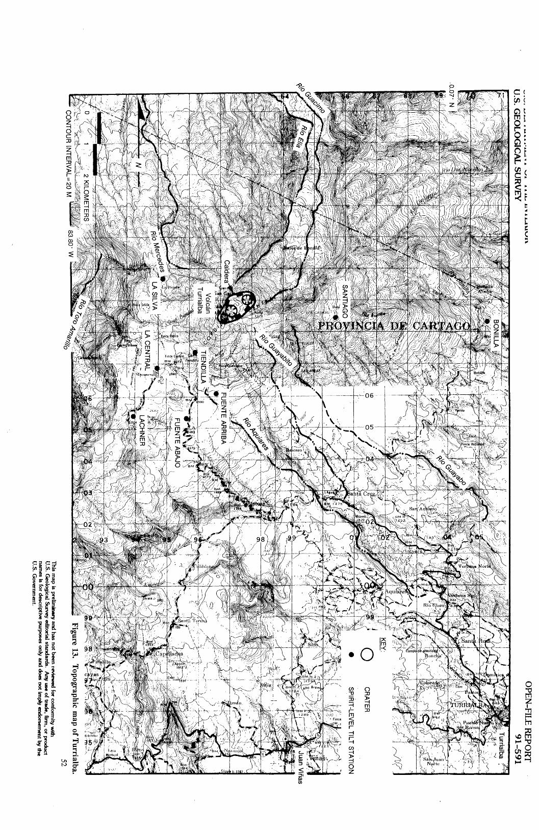
A A
1.1
Ill
* J
UJIV
IVS
II
U.S. G
EO
LO
GIC
AL
SUR
VE
YO
PEN
-FILE
RE
POR
T
91-591
Juan Vinas
BONILLA w$&£$-
\
0.07- N I
CR
ATE
R
SP
IRIT
-LEV
EL T
ILT S
TA
TIO
N
H\
V '^
r4<
-
V/ i^H
t-1,d
/ -^
T;5
S-<
r=L
VM
ll1
. "
f'l^-f^
Volcein
TurrialbaT
IEN
DIL
LA
j
LA S
ILVA
s&
2 KILO
ME
TE
RS
*^
mr'-i,---
\X^i^
li/Sm
kf.
~~
~
fcte
CO
NT
OU
R IN
TE
RV
AL=
20 MFigure 13.
Topographic m
ap of Turrialba.
52T
his map is prelim
inary and has not been
reviewed for conform
ity with
U.S. G
eological Survey editorial standards. A
ny use of trade, firm
, or product nam
es is for descriptive purposes only and does not im
ply endorsement by th
e U
.S. Governm
ent.
CIVIL DEFENSE HIERARCHY AND DISASTER PREPAREDNESS: According to the National Emergency Plan, the President directs the Civil Defense during a national emergency. An Executive Committee of Civil Defense is formed from representatives of the various ministries and selected government and private institutions. This plan has not been practiced. Most emergencies have been handled by the National Emergency Commission (CNE), which is under the jurisdiction of the Ministry of Public Works and Transportation (MOPT). The Executive Office of CNE oversees the use of emergency funds. The Emergency Operations Center is a communications office that maintains 24-hour contact with the Civil and Rural guards, the Electric Company (ICE), and the Red Cross to inform the CNE of possible emergencies.
OTHER RELIEF AGENCIES
Costa Rican Red Cross (CRCR)14th Ave. between 6th and 8th Streets San Jos6, Costa Rica Telephone: 33-70-33
United Nations Development Program (UNDP)Palais des Nations CH-1211 Geneve 10 Switzerland Telephone: 4122 7310-211, 7346-011 FAX: 4122 7335-623
GENERAL COUNTRY DATAPOPULATION: 2,460,226 (1984 Census) TIME ZONE: = GMT - 6CURRENCY: 109 colones = $1 (10-1-91)PHONE EXCHANGE: US to CR, 011-506-(#)
CRtoUS, 116-(#)RAINY SEASON: May to October
Mountains in the central highlands create a rainshadow effect that inhibits rainfall on the Pacific coast and the southern Guanacaste area.
53

PRECIPITATION (Monthly mean in mm)*: San Jos6 (1931-1960) Lat. 9.93° N Long. 84.13° W, elevation 1,120 m
330 -
300 -
250 -
200 -
130 -
"From Schwerdtfeger, 1976, Climates of Central and South America
TEMPERATURE (Monthly mean in °C) AS A FUNCTION OF ELEVATION*:
Elevation (meters)
3,000
2,500
2,000
1,500
1,000
500
M.S.L.
January
6.0
11.0
14.9
17.3
20.3
23.5
27.8
April
10.4
13.9
16.6
19.4
23.9
26.6
28.9
July
8.4
13.1
16.5
19.1
22.1
25.1
28.0
October
6.9
11.0
14.8
18.6
21.5
24.1
26.7
*From Schwerdtfeger, 1976, Climates of Central and South America
54

ATMOSPHERIC PRESSURE: The trends are characterized by a double diurnal pressure wave. The minimums occur around 4 AM and 4 PM local time. The maximums occur around 10 AM and 10 PM local time.
WINDS: NE tradewinds (from NOAA, Monthly climatic data for the world) *data for San Jose, Costa Rica
January
February
March
April
May
June
July
August
September
October
November
December
Direction* Speed**
Direction Speed
Direction Speed
Direction Speed
Direction Speed
Direction Speed
Direction Speed
Direction Speed
Direction Speed
Direction Speed
Direction Speed
Direction Speed
No data
No data
79 32
55 18
105 4
407
No data
No data
No data
No data
No data
No data
in degrees ** meters per second
ELECTRIC SUPPLY: 110-120VAC, 60 Hz, single phase; 220-240VAC is available for larger appliances. Transformers are not needed when using U.S.-made electric products.
COMMUNICATIONS: Costa Rica has a well developed communications network. Nearly everyone has a radio and many have televisions. The Institute Costarricense de Electricidad (ICE) manages the telephone system.
55

GEOLOGIC ORGANIZATIONS AND INFORMATION SOURCES: Geologic information and related technical resources are provided by a variety of organizations listed below. Four of these (ICE, UCR, OVSICORI, and UNA) are directly interested in and/or responsible for volcano/seismic hazards in Costa Rica.
- Ministerio de Energia Minos y Petroleo, under which is the Department of Geology and Mines. They produce generalized geologic maps at a scale of 1:200,000.
- ICE - Institute Costarricense de Electricidad; an autonomous organization with the longest history in seismologic studies in Costa Rica. They are located at Apdo. 10032-1000, San Jos£, Costa Rica, Telephone - (506)207141; Telefax - (506)333871; Telex - (376)2140. In 1974, the Arenal seismic net (Red Sismoldgica Nacional, RSN) was established in coordination with the University of Texas at Galveston. In 1982, a national seismic net (RSN) was established. In 1990 it consisted of 15 stations located throughout the country. Four of these are located close to active volcanoes: Miravalles, Arenal, Pods, and Irazu. ICE also has 8 portable seismographs. ICE has published the Boletin del Observatorio Vulcanologico del Arenal since 1988.
STAFF 1990 (from Directory of Volcano Observatories, WOVO) Alvarado, Guillermo - Petrology, tectonics Barquero, Rafael - Seismology Barrantes, Jos£ Miguel - Electronics Boschini, Ileana - Seismology Calvo, Guido - Electronics Cordero, Carlos - Topography Ferndndez, Jose" Francisco - Chemistry Leandro, Carlos - Gravimetry and magnetometry Mora, Sergio - Geological hazards Soto, Gerardo - Geology, Tumalba
- UCR - Universidad de Costa Rica, San Jos^ - This organization is affiliated with ICE and has a bachelor-of-science program in geology.
STAFF 1989Borgia, Andrea - Geology, Arenal Ferndndez, Mario - Geology Kussmaul, Sigfried - Geology and petrology Montero, Walter - Seismology Morales, Luis Diego - Seismology Paniagua, Sergio - Volcanology
- OVSICORI - Observatorio Vulcandlogico y Sismoldgico de Costa Rica - This group has been publishing the Boletin de Vulcanologfa since 1979. They are located at Apdo 86, Heredia 3000, Costa Rica, Telephone - (506)374570, 376363; Telefax - (506)380086; Telex - (376)7550 UNAVI CR.
STAFF 1990Barbosa, Vilma - Volcanic seismology Barquero, Jorge - Director, Volcanology, geochemistry
56
Bravo, Juan - Geomorphology, La Fortuna, TenorioBrenes, Jorge - Geology, seismologyDuarte, Eliecer - Turrialba geomorphology, demographicsFerna"ndez, Eric - GeochemistryGonzales, Victor - Coordinates with UNA, seismology, computer specialistGuendel, Federico - Director, seismologyHerndndez, Fernando - Geodesy, deformationMalavassi, Eduardo - Petrology, Arenal, Quaternary cinder conesMarino, Tomas - Geodesy, deformationMata, Antonio - ElectronicsMontero, Carlos - SeismologyProtti, Marino - Seismology, tectonicsRojas, Daniel - ElectronicsS£enz, Rodrigo - Volcanologyde Dios Segura, Juan - SeismologyVan der Laat, Rudolofo - Geodesy, deformation
- UNA - Universidad Nacional Autonoma, Campus Omar Dengo, Heredia. This organization is affiliated with OVSICORI.
Raccichini, Sergio - Volcanic hazards
Photographs and maps are available through:Ministerio de Obras Publicas y Transportacidn (MOPT) Avenida 20, Calles 9/11 San Jos6, Costa Rica
Maps cost $4.00 each (1989). Arnold de Soto is a section head of Remote Sensing geology. Three-fourths of Costa Rica has Landsat coverage. Maps are also available through Inter-American Geodetic Survey (LAGS).
IGN (Institute Gr£fico Nacional) does first-order leveling.
57
OTHER EARTH SCIENTISTS and associated organizations involved in Costa Rican volcanology (Specialty listed after name)
Brantley, Susan (geochemistry, Poas) Department of Geosciences Penn State University State College, PA 16802 USA
Brown, Geoff (microgravity, Pods)Department of Earth SciencesThe Open UniversityWalton HallMilton Keynes, MK76AA, UK
Carr, Michael (geochemistry, Rincdn de laVieja, Arenal)Department of GeologyRutgers CollegeNew Brunswick, New Jersey 03755USA
Casadevall, Tom (geochemistry, Pods,Arenal)U.S. Geological SurveyDenver Federal CenterP.O. Box 25046Lakewood, CO 80225USA
Casertano, Lorenzo (geochemistry, Pods) Institute of Geology and Geophysics University of Naples Naples Italy
Cigolini, Corrado (petrology, Arenal) Institute of Petrography University of Turin Via San Massimo 24 Turin, Italy
Corrado, G. (deformation, Arenal) Institute di Geologia e Geoflsica Universitd di Napoli Largo S. MarcelUno 10 Napoli, Italy
Escalante, G. (Irazu, Pods) Costa Rican Civil Defense San Jose, Costa Rica
Gill, Jim (geochemistry, Turrialba) Earth Sciences Board University of California Santa Cruz, CA 95064 USA
Harlow, David (seismology) U.S. Geological Survey 345 Middlefield Rd. MS-977 MenloPark, CA 94025 USA
Kempter, Kurt (Rincdn de la Vieja, Cacao) Louisiana State University Baton Rouge, La. 70803-4101 USA
Krushensky, R.D. (Irazu) U.S. Geological Survey National Center Reston, VA 22092 USA
McNally, Karen (seismology)University of Calif., Santa Cruz1156 High St.Santa Cruz, CA 95064USA
Melson, William (eruption dynamics,Arenal)Museum of Natural HistorySmithsonian Institution MS-129Washington, D.C. 20560USA
58
Prosser, Jerome (petrology, Poas) Texasgulf Minerals and Metals 239 South Elliott Rd. Chapel Hill, NC 27514 USA
Reagan, Mark (Turrialba, hazards,petrology)University of IowaIowa City, Iowa 52242USA
Rose, Bill (geochemistry) Michigan Technological University Houghton, MI 49931 USA
Rowe, Gary (geochemistry, Poas) Department of Geosciences Penn State University State College, PA 16802 USA
Rymer, Hazel (microgravity, Pods)Department of Earth SciencesThe Open UniversityWalton HallMilton Keynes, MK76AA, UK
Sheridan, Mike (stratigraphy) SUNY at Buffalo, Geology Dept. 424 Ridge Lea Campus Buffalo, NY 14260 USA
Sussman, David (geochemistry, Rincon de laVieja)UNOCAL Geothermal Division3576 Unocal PI.P.O. Box 6854Santa Rosa, CA 95406USA
Wadge, G. (Arenal, deformation) Department of Geography University of Reading White Knights, RG 6 2AB UK
Walker, George (stratigraphy) Department of Geology University of Hawaii 2525 Correa Rd. Honolulu, HI 96822 USA
White, Randy (seismology) U.S. Geological Survey 345 Middlefield Rd. MS- 977 Menlo Park, CA 94025 USA
EARTH SCIENCE ORGANIZATIONS
CEPREDENAC (volcanic hazards) El Centre de Coordinacion para la Prevencion de desastres naturales en America Central 7a. Av. 14-57 Zona 13 Guatemala Cuidad, Guatemala, C.A. Phone 502-2-313967, 314967 FAX 502-2-363944
Earthwatch Brian Rosborough 680 Mount Auburn St. P.O. Box 403 Watertown, MA 02272 Phone (617) 926-8200
Institut de Physique du Globe de ParisObservatoires Volcanologiques (gasgeochemistry)J.L. Cheminee4 place Jussieu75252 Paris Cedex 05, France
Japan International Cooperation Agency(JICA)P.O. Box 216Mitsui BuildingShinjuku, Tokyo 163
RET Corporation (seismic engineering) Deborah Reid-Jerez 6551 Loisdale Ct. Springfield, VA 22150 Phone (703) 922-9713
59
Earth Science Organizations (con't)USGS/OFDA Volcanic Disaster AssistanceProgramVolcano Crisis Assistance Team(volcanic hazards)Cascades Volcano Observatory5400 MacArthur Blvd.Vancouver, WA 98661 USAPhone (206) 696-7693Fax (206) 696-7866
EMBASSIESU.S. Mission in Costa Rica
Embassy of the United States and USAID MissionAvenida 3 and Calle 1San Jos6, Costa RicaPhone: 20-39-39(APO Miami, Fl. 34020)
Office of Foreign Disaster Assistance maintains a regional office for Latin America in San Jose" to perform assessments following disasters and to coordinate OFDA responses. The office is located at: USAID Annex, General Development Division, at the U.S. Embassy (tel. 33- 86-45, 33-93-29, 24,54,14). This team of three disaster specialists maintains a portable, battery operated radio communications system and ten 4-wheel drive vehicles.
OFDA Regional Advisors Bell, Paul Bermudez, Ricardo James, Alejandro
French Mission in Costa Rica Japanese Mission in Costa RicaFrench Consulate Japanese EmbassyCalle 5, Avenidas 1/3 (No. 140) Apdo. 501 E 10San Jos6, Costa Rica 145 San Jos6, Costa RicaPhone: 22-11-4 Phone: 32-12-55FAX: 3037600-2191 FAX: 313140Telex: 3032191 Telex: C.2205 A.2205 TAISI
Italian Mission in Costa RicaItalian EmbassyCalle 29 Avenida 8 y 10Casa 842 Ap 1729San Jos6, Costa RicaPhone 24-65-47FAX: noneTelex: 003762769, Ans: ITALDIPL
60

BIBLIOGRAPHY
Alvarado, G., 1984, Aspectos petroldgicos-geoldgicos de los volcanes y unidades lavicas delCenozoico Superio de Costa Rica: Tesis de Licenciatura, Escuela Centroamericana de Geologfa, Universidad de Costa Rica, San Jose\ 183 p. (unpublished).
Alvarado, G.E., 1989, Los volcanes de Costa Rica: Universidad Estatal a Distancia, San Jose", Costa Rica, 175 p.
Alvarado, G. E., and Barquero, R., 1987, Las senales sismicas del Volcin Arenal (Costa Rica) y su relacidn con las fases eruptivas (1968-1986): Ciencia y Tecnologia, v. 11, no. 1, p. 15-35.
Alvarado, G.E., Dominguez, S.A., and Calderdn, C.C., 1988, Interpretacidn preliminar de las deformaciones associadas al Volcdn Arenal (Costa Rica): Boletin del Observatorio Vulcanologico del Arenal, Ano 1, no. 2, p. 26-43.
Barquero, J., 1976, El Volcdn Irazu y su actividad: Tesis de Licenciatura, Escuela de Ciencias Geograficas, Universidad Nacional, Heredia, 63 p.
Barquero, J., and de Dios Segura, J., 1983, La actividad del Volcdn Rincdn de la Vieja: Boletin Vulcanologia, v. 13, p. 5-10.
Barquero, J., and Ferndndez, E., 1987, Estados de los volcanes en Costa Rica: Boletin Vulcanologia, v. 18, p. 5-6.
Barquero, J, and Ferndndez, E., 1989, Estado de los volcanes, Enero 1988 - Mayo 1989: Boletin de Vulcanologia, v. 20, p. 5-7.
Barquero, J., and Malavassi, E., 1982, Field guide for U.S.-C.R. joint seminar in volcanology: San Jose\ 21 p.
Barquero, R., 1987, Estudio sismoldgico compilativo, Proyecto Geotermico Miravalles: Institute Costarricense de Electricidad, San Jose\ Costa Rica, 23 p.
Barquero, R., 1989a, Miravalles Volcano and geothermal project (Costa Rica): monitoring and geological setting: Boletin Observatorio Vulcanoldgico del Arenal, Ano, no. 3, p. 22-27.
Barquero, R., 1989b, Estudio geoquimico preliminar de fuentes termales y frias del Volcan Arenal: Boletin del Observatorio Vulcanologico del Arenal, ano 2, no. 3, p. 38-55.
Barquero, R., and Alvarado, G., 1988, Volcanoes of Costa Rica: Institute Costarricense de Electricidad, San Jose\ 11 p.
Blong, R.J., 1984, Volcanic hazards, a sourcebook on the effects of eruptions: Academic Press, Orlando, FL, 424 p.
61

Borgia, A., Linneman, S., Spencer, D., Morales, L.D., and Andre, J.B., 1983, Dynamics of lava flow fronts, Arenal Volcano, Costa Rica: Journal of Volcanology and Geothermal Research, v. 19, p. 303-329.
Borgia, A., Poore, C, Carr, M.J., Melson, W.G., and Alvarado, G.E., 1988, Structural,stratigraphic, and petrologic aspects of the Arenal-Chato volcanic system, Costa-Rica: evolution of a young stratovolcanic complex: Bulletin Volcanologique, v. 50, p. 86-105.
Boza, M.A., and Mendoza, R., 1981, The National Parks of Costa Rica: Costa Rican Institute of Tourism, San Jose, Costa Rica, 310 p.
Brantley, S.L., Borgia, A., Rowe, G., Ferndndez, J.F., and Reynolds, J.R., 1987, Pods volcanocrater lake acts as a condenser for acid metal-rich brine: Nature, v. 330, no. 6147, p. 1-3.
Bravo, J., Barquero, J., Ferndndez, E., Sdenz, R., and Melson, W., 1989, Geomorfologia del complejo volcanico Tenorio: Boletin de Vulcanologia, v. 20, p. 11-14.
Bulletin of volcanic eruptions, Annual reports of the world volcanic eruptions: Volcanological Society of Japan.
Carr, M.J., 1976, Underthrusting and Quaternary faulting in northern Central America: Geological Society of America Bulletin, v. 87, p. 825-829.
Carr, M.J., 1984, Symmetrical and segmented variation of physical and geochemicalcharacteristics of the Central American volcanic front: Journal of Volcanology and Geothermal Research, v. 20, p. 231-252.
Carr, M.J., Chesner, C.A., and Gemmel, J.B., 1985, New analyses of lavas and bombs from Rinc6n de la Vieja Volcano, Costa Rica: Boletin de Vulcanologia, v. 16, p. 23-30.
Carr, M.J., Rose, W.I., and Stoiber, R.E., 1982, Volcanism in Central America, in Thorpe, ed., Andesites. Orogenic Andesites and Related Rocks, John Wiley, New York, p. 149-166.
Carr, M.J., and Stoiber, R.E., 1977, Geologic setting of some destructive earthquakes: Geological Society of America Bulletin, v. 88, p. 153-156.
Carr, M.J., and Stoiber, R.E., 1988, Volcanism: in Dengo, G., and Case, E., eds., The Caribbean region: Geological Society of America, The Geology of North America, Boulder, Colorado, v. H, p. 375-391.
Casadevall, T.J., Rose, W.I. Fuller, W.H., Hunt, W.H., Hart, M.A., Movers, J.L., Woods, D.C., Chuan, R.L., and Friend, J.P., 1984, Sulfur dioxide and particles in quiescent volcanic plumes from Pods, Arenal, and Colima volcanoes, Costa Rica and Mexico: Journal of Geophysical Research, v. 89, no. D6, p. 9633-9641.
Casertano, L., Borgia, A., and Cigolini, C., 1982, Geophysical investigations at Pods Volcano, Costa Rica: Boletin de Vulcanologia, v. 14, p. 94-97.
62
Casertano, L., Borgia, A., Cigolini, C, Morales, L.D., Montero, W., Gomez, ML, and Fernandez, J.F., 1985, Investigaciones geofisicas y caracteristicas geoqufmicas de las aguas hidrotermales: Volcan Poas, Costa Rica: Geofisica Internacional, v. 24, p. 315-332.
Casertano, L., Borgia, A., Cigolini, C., Morales, L.D., Montero, W., Gomez, M., and Ferndndez, J.F., 1987, An integrated dynamic model for the volcanic activity at Pods Volcano, Costa Rica: Bulletin of Volcanology, v. 49, p. 588-598.
Castillo, R., 1977, Reconocimiento geo!6gico preliminar de una parte de las faldas del CerroCacao, Cordillera de Guanacaste, Costa Rica: CODESA, Boletin Geologia y de Recursos Minerales, v. 1, p. 268-279.
Corrado, C., Borgia, A., and Casertano, L., 1984, Intra-crater activity, A'a - block lava, viscosity and flow dynamics: Arenal Volcano, Costa Rica: Journal of Volcanology and Geothermal Research, v. 20, p. 155-176.
De la Haya, D., 1852, La actividad del Volcdn Irazu en 1723: Revista Geografia de America Central, v. 4, p. 203-210.
Directory of Volcano observatories 1990-1991, 1991, World Organization of Volcano Observatories/UNESCO, Reykjavik, 99 p.
Feigenson, M.D., and Can, M.J., 1986, Positively correlated Nd and Sr isotope ratios of lavas from the Central American volcanic front: Geology, v. 14, p. 79-82.
Francis, P.W., Thorpe, R.S., Brown, G.C., and Glasscock, J., 1980, Pyroclastic sulfur eruption at Pods volcano, Costa Rica: Nature, v. 283, p. 754-756.
Fudali, R.F., and Melson, W.G., 1977, Ejecta velocities, magma chamber pressure and kinetic energy associated with the 1968 eruption of Arenal Volcano: Bulletin Volcanologique, v. 35, no. 2, p. 383-401.
GalU-Olivier, C., 1979, Ophiolite and island-arc volcanism in Costa Rica: Geological Society of America Bulletin, Part I, v. 90, p. 444-452.
Gemmell, J.B., 1987, Geochemistry of metallic trace elements in fumarolic condensates from Nicaraguan and Costa Rican volcanoes: Journal of Volcanology and Geothermal Research, v. 33, p. 161-181.
Guendel, F., McNally, K.C., Lower, J., Protti, M., Sdenz, R., Malavassi, E., Barquero, J., Van der Laat, R., Gonzales, V., Montero, C., Ferndndez, E., Rojas, D., Segura, de Dios, J., Mata, A., and Solis, Y., 1989, First results from a new seismographic network in Costa Rica, Central America: Bulletin of the Seismological Society of America, v. 79, no. 1, p. 205-210.
Hantke, G., 1951, Ubersicht iiber die vulkanische tatichkeit 1941-1947: Bulletin Volcanologique, v. 11, ser. 2, p. 161-208.
63
Harris, S.A., 1971, Quaternary vulcanicity in the Talamanca Range of Costa Rica: Canadian Geotechnical Journal, v. 15, p. 141-145.
Healy, J., 1969, Notas sobre los volcanes de la sierra volcanica de Guanacaste, Costa Rica: Inst. Geog. Nac. Informe Semestral, v. 15, p. 37-47.
Hudnut, K.W., 1983, Geophysical survey of Irazu Volcano: Senior Honors thesis, Dartmouth College, 93 p.
Hudnut, K.W., Williams, S.N., and Stoiber, R.E., 1983, Geological and geophysical study of Irazu volcano, Costa Rica: in EOS, Transactions of the American Geophysical Union Annual Meeting, San Francisco, v. 64, p. 892.
Kellogg, J.N., 1988, Plate motion measurements with satellite geodesy in the northern Andes: Journal of South American Earth Sciences, v. 1, no. 4, p. 419-421.
Kempter, K.A., and Benner, S.G., 1989, Rinc6n de la Vieja Volcano, northwestern Costa Rica: Evolution of a compound stratovolcano [abstract]: in Continental Magmatism Abstracts, New Mexico Bureau of Mines and Mineral Resources, Bulletin 131, p. 150.
Krinsley, D., in press, The human economic losses of natural disasters: Proceedings of the Sixth Circum-Pacific Energy and Mineral Resources Conference.
Krushensky, R.D., 1973, Geology of the Istaru Quadrangle, Costa Rica: Geological Survey Bulletin 1358, p. 1-46.
Krushensky, R.D., and Escalante, G., 1967, Activity of Irazu and Pods volcanoes, Costa Rica, November 1964-July 1965: Bulletin Volcanologique, v. 31, p. 75-84.
Malavassi, R., 1979, Geology and petrology of Arenal Volcano, Costa Rica: Unpub. M.S. thesis, University of Hawaii, 111 p.
Malavassi, E.R., 1982, Petrology of Arenal Volcano: Boletin de Vulcanologia, v. 6, p. 61-64.
Masure, P., in press, Taking natural hazards into account in development projects: A necessity for Latin American and Caribbean countries: Proceedings of the Sixth Circum-Pacific Energy and Mineral Resources Conference.
McClelland, L., Simkin, T., Summers, M., Nielsen, E., and Stein, T., eds., 1989, Global Volcanism 1975-1985: Smithsonian Institution, 655 p.
Melson, W.G., 1982, Alternation between acidic and basic magmas in major explosive eruptions of Arenal Volcano, Costa Rica: Boletin de Vulcanologia, v. 14, p. 65-74.
Melson, W.G., 1984, Prehistoric eruptions of Arenal volcano, Costa Rica: Vinulos, v. 10, no. 1-2, p. 34-59.
64

Melson, W.G., Barquero, J., Saenz, R., and Ferndndez, E., 1986, Erupciones explosivas de importancia en volcanes de Costa Rica: Boletin de Vulcanologfa, v. 16, p. 15-20.
Melson, W.G. and Sa"enz, R., 1973, Volume, energy and cyclicity of eruptions of Arenal volcano, Costa Rica: Bulletin Volcanologique, Tome 37, no. 3, p. 416-437.
Melson, W.G., S£enz, R., Barquero, J., and Ferndndez, E., 1988, Edad relativa de las erupciones del Cerro Congo y Laguna Hule: Boletin de Vulcanologia, v. 19, p. 8-10.
Miller, C.T., 1970, The Eruption of Arenal: Pacific Discovery, California Academy of Sciences v. 23, no. 1, p. 25-31.
Minakami, T., 1960, Fundamental research for predicting volcanic eruptions: Earthquakes and crustal deformations originating from volcanic activities: Bulletin of the Earthquake Research Institute, v. 38, p. 497-544.
Minakami, T., Utibori, S. and Hiraga, S., 1969, The 1968 eruption of Volcano Arenal, Costa Rica: Bulletin of the Earthquake Research Institute, v. 47, p. 783-802.
Molnar, P., and Sykes, L.R., 1969, Tectonics of the Caribbean and Middle America Regions: Geological Society of America Bulletin, v. 80, p. 1639-1646.
Mooser, F., Meyer-Abich, H., and McBirney, A.R., 1958, Catalogue of the Active Volcanoes of the World, Part VI, Central America: International Volcanology Association, Napoli, Italy, 148 p.
Mora, S., 1987, Analisis preliminar de la amenaza y vulnerabilidad potenciales generadas por el Rio Reventador y el deslizamiento de San Bias, Cartago, Costa Rica: Technologia en Marcha, v. 9, no. 1, p. 19-37.
Murata, K.J., Dondoli, C, and Sa"enz, R., 1966, The 1963-65 eruption of Irazu Volcano, Costa Rica (The period of March 1963 to October 1964): Bulletin Volcanologique, v. 29, p. 765-793.
Newhall, C.G., and Dzurisin, 1988, Historical unrest at large calderas of the world: U.S. Geological Survey Bulletin 1855, 1108 p.
NOAA, and World Meteorological Organization, 1976, Monthly climatic data for the world: National Climatic Center, Ashville, N.C., v. 29, p. 5.
Paniagua, S., and Soto, G, 1988, Peligros volcanicos en el Valle Central de Costa Rica: Escuela Centroamericana de Geologia-Red Sismol6gico Nacional, Universidad de Costa Rica, 12P-
Prosser. J.T., 1983, The geology of Poas Volcano, Costa Rica: Unpub. M.S. thesis Dartmouth College, New Hampshire, 165 p.
65
Prosser, J.T., and Carr, M., 1987, Po£s volcano, Costa Rica: Geology of the summit region and spatial and temporal variations among the most recent lavas: Journal of Volcanology and Geothermal Research, v. 33, p. 131-146.
Protti, R., 1986, Geologia del flanco sur del Volcan Barva: Boletin de Vulcanologia, v. 17, p. 23-31.
Raccichini, S., 1977, Criterios para la zonificacidn de Costa Rica en base al riesgo volcanico potential: Revista Geografica, v. 86-87, p. 147-160.
Reagan, M.K., 1987, Turrialba Volcano, Costa Rica: Magmatism at the southeast terminus of the Central American Arc: Unpublished Ph.D. thesis, University of California, Santa Cruz, 216 p.
Reagan, M.K., and Gill, J.B., 1989, Coexisting calcalkaline and high-niobium basalts fromTurrialba volcano, Costa Rica: implications for residual titanates in arc magma sources: Journal of Geophysical Research, v. 94, no. B4, p. 4619-4633.
Reagan, M.K., Gill, J.B., Malavassi, E., and Garcia, M.O., 1987, Changes in magma composition at Arenal volcano, Costa Rica, 1968-1985: Real-time monitoring of open-system differentiation: Bulletin Volcanologique, v. 49, p. 415-434.
Rymer, H., and Brown, G.C., 1987, Causes of microgravity change at Pea's Volcano, Costa Rica: An active but non-erupting system: Bulletin Volcanologique, v. 49, p. 389-398.
Sa"enz, R., 1974, Volcanic prediction in Costa Rica: Bulletin Volcanologique, v. 37, no. 3, p. 401- 405.
Sa"enz, R., 1982, Edades radiom&ricas de algunas rocas de Costa Rica: Boletin de Vulcanologia, v. 8, p. 8-10.
Saenz, R., Barquero, J., and Malavassi, E., 1982, Erupcion estromboliana del Volcdn Irazu periodo active 1963-65: Boletin de Vulcanologia, v. 14, p. 101-116.
Santana, A.I., 1977, Geologia de un area de las hojas Miravalles y Tierras Morenas: Tesis de Licenciatura, Universidad de Costa Rica, 89 p.
Sapper, K., 1925, Los volcanes de la America Central: Verlag-Max Niemayer, Halle, 144 p.
Scott, W.E., 1989, Volcanic and related hazards, in Tilling, R.I., ed., Volcanic Hazards, Shortcourse in Geology: Volume 1: American Geophysical Union, Washington, D.C., p. 9-23.
Simkin, T., Siebert, L., McClelland, L., Bridge, D., Newhall, C, and Latter, J.H., 1981, Volcanoes of the World: Smithsonian Institution, Hutchinson Ross Publishing Co., Stroudsburg, Pa., 232 p.
Stoiber, R.E., and Carr, M.J., 1973, Quaternary volcanic and tectonic segmentation of Central America: Bulletin Volcanologique, v. 37, p. 304-324.
66

Stoiber, R.E., and Rose, W.I., 1970, The geochemistry of Central American volcanic gas condensates: Geological Society of America Bulletin, v. 81, p. 2891-2912.
Stoiber, R.E., and Rose, W.I., 1974, Fumarole incrustations at active Central American volcanoes: Geochimica et Cosmochimica Acta, v. 38, p. 495-516.
Thorpe, R.S., Locke, C.A., Brown, G.C., Francis, P.W., and Randal, M., 1981, Magma chamber below Pods volcano, Costa Rica: Journal of the Geological Society of London, v. 138, p. 367-373.
Vasconez, K.C., 1987, Costa Rica, a country profile: Office of U.S. Foreign Disaster Assistance, Agency for International Development, 128 p.
Von Frantzius, A., 1981, Cuadro sindptico de las cadenas volcdnicas de Costa Rica in Vargas, C.A., ed., Antologia del Volcdn Pods: San Jose\ Universidad de Estatal a Distancia, p. 11-32.
Wadge, G., 1982a, El campo de flujos de lava 1968-1980 y las ratas de erupcion de magma en el volcdn Arenal: Boletin de Vulcanologia, v. 14, p. 75-78.
Wadge, G., 1982b, Steady state volcanism: Evidence from eruption histories of polygenetic volcanoes: Journal of Geophysical Research, v. 87, no. B5, p. 4035-4049.
Wadge, G., 1983, The magma budget of Volcan Arenal, Costa Rica from 1968 to 1980: Journal of Volcanology and Geothermal Research, v. 19, p. 281-302.
Waldron, H.H., 1967, Debris flow and erosion control problems caused by the ash eruptions of Irazu Volcano, Costa Rica: U.S. Geological Survey Bulletin 1241-1, p. 1-35.
Walker, J.P.L., 1982, Volcanic Hazard: Boletin de Vulcanologia, v. 14, p. 41-48.
Weyl, R., 1980, Geology of Central America: Berlin, Gebruder Borntraeger, 371 p.
White, R.A., in press, Significant shallow volcanic chain earthquakes of Central America:Proceedings of the Sixth Circum-Pacific Energy and Mineral Resources Conference.
Wood, R., 1974, Microearthquakes at Central American volcanoes: Bulletin of the Seismological Society of America, v. 64, no. 1, p. 275-277.
Woodruff, L.G., Rose, W.I., and Rigot, W., 1979, Contrasting fractionation patterns forsequential magmas from two calc-alkaline volcanoes in Central America: Journal of Volcanology and Geothermal Research, v. 6, p. 217-240.
67

MAT
31721273338465161657379
68