u.s. department of the interior geologic map … · balkwill (1964). new geologic mapping in the...
TRANSCRIPT

U.S. DEPARTMENT OF THE INTERIOR
U.S. GEOLOGICAL SURVEY
GEOLOGIC MAP OF THE HART PEAK QUADRANGLE, CALIFORNIA AND
NEVADA
by
Jane E. Nielson 1 and Ryan D. Turner2
Open-File Report 98-470
Although here released in the Open File series, this report has been reviewed for conformity with U.S. Geological Survey editorial standards and the North American Stratigraphic Code. Any use of trade, product, or firm names is for descriptive purposes only and does not imply endorsement by the U.S. government.
1 Emeritus, 345 Middlefield Road, Menlo Park, CA, 940252 Turner Associates, Chapel Hill, North Carolina
1998
DEPARTMENT OF THE INTERIOR U.S. GEOLOGICAL SURVEY
TO ACCOMPANY MAP OF 98-470
GEOLOGIC MAP OF THE HART PEAK QUADRANGLE, CALIFORNIA AND NEVADA
by
Jane E. Nielson and Ryan D. Turner
INTRODUCTIONThe Hart Peak 1:24,000-scale quadrangle is located
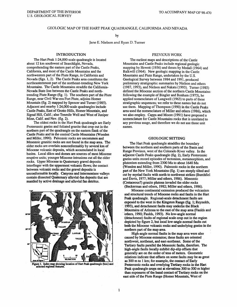
about 12 km southwest of Searchlight, Nevada, comprehending the eastern part of the Castle Peaks, California, and most of the Castle Mountains and the northwestern part of the Piute Range, in California and Nevada (figs. 1,2). The Castle Peaks area constitutes the northeasternmost part of the northeast-trending New York Mountains. The Castle Mountains straddle the California- Nevada State line between the Castle Peaks and north- trending Piute Range (fig. 1). The southern part of the Piute Range, near Civil War-era Fort Piute, adjoins Homer Mountain (fig. 2) mapped by Spencer and Turner (1985). Adjacent and nearby l:24,000-scale quadrangles include Castle Peaks, East of Grotto Hills, Homer Mountain, and Signal Hill, Calif.; also Tenmile Well and West of Juniper Mine, Calif, and Nev. (fig. 2).
The oldest rocks in the Hart Peak quadrangle are Early Proterozoic gneiss and foliated granite that crop out in the northern part of the quadrangle on the eastern flank of the Castle Peaks and in the central Castle Mountains (Wooden and Miller, 1990). Paleozoic rocks are uncommon and Mesozoic granitic rocks are not found in the map area. The older rocks are overlain nonconformably by several km of Miocene volcanic deposits, which accumulated in local basins. Local dikes and domes are sources of most Miocene eruptive units; younger Miocene intrusions cut all the older rocks. Upper Miocene to Quaternary gravel deposits interfinger with the uppermost volcanic flows; the contact between volcanic rocks and the gravel deposits is unconformable locally. Canyons and intermontane valleys contain dissected Quaternary alluvial-fan deposits that are mantled by active drainage and alluvial fan detritus.
Figure 1. Index mm showing location of Hatt Peak quadrangle (box) and selected regional features.
PREVIOUS WORKThe earliest maps and descriptions of the Castle
Mountains and Castle Peaks include regional geologic mapping by Hewett (1956) and theses by Medall (1964) and Balkwill (1964). New geologic mapping in the Castle Mountains and Piute Range, undertaken by the U.S. Geological Survey between 1984 and 1991, produced preliminary stratigraphic summaries by Nielson and others (1987,1993), and Nielson and Nakata (1993). Turner (1985) defined the Miocene section of the northern Castle Mountains: following the example of Bingler and Bonham (1973), he applied nomenclature of Longwell (1963) to parts of these stratigraphic sequences; we refer to these names but do not use them. Mapping of Thompson (1990) in the Castle Peaks area used the nomenclature of Miller and others (1986), which we also employ. Capps and Moore (1991) have proposed a nomenclature for Castle Mountains rocks that is unrelated to any previous usage, and therefore we do not use those unit names.
GEOLOGIC SETTINGThe Hart Peak quadrangle straddles the boundary
between the northern and southern parts of the Basin and Range Province, west of the Colorado River valley. In the adjacent Castle Peaks quadrangle (fig. 2), Early Proterozoic gneiss units record episodes of tectonism, metamorphism, and plutonism extending from 2300 Ma to about 1640 Ma (Wooden and Miller, 1990). Paleozoic rocks in the northern part of the New York Mountains (fig. 1) are steeply tilted and cut by myriad faults with north to northwest strikes (Burchfiel and Davis, 1977; Miller and others, 1986). Mesozoic (Cretaceous?) granite plutons invaded the older rocks (Beckerman and others, 1982; Miller and others, 1986).
Miocene continental extension produced the volcanism and structural trends of Miocene rocks and faults in the Hart Peak quadrangle. Regional-scale detachment faults are exposed to the west in the Kingston Range (fig. 1; Reynolds, 1993), and detachment faults may underlie the Black Mountains of Arizona to the east of the map area (Faulds and others, 1990; Faulds, 1993). No low-angle normal (detachment) faults of regional scale crop out in the region depicted by figure 2, but local low-angle normal faults cut both the Miocene volcanic rocks and underlying gneiss in the northern part of the map area.
High-angle normal faults in the map area were also caused by Miocene extension; these faults are oriented northwest, northeast, and east-northeast. Some of the Tertiary faults parallel the Mesozoic faults, therefore. The high-angle faults locally exhibit dip-slip offsets that generally are on the order of tens of meters. Geometric relations indicate that offsets on some faults may be as great as 300 m to 1 km; for example, the contact of Early Proterozoic rocks and overlying Tertiary rocks in the Hart Peak quadrangle crops out at elevations 300 to 500 m higher than exposures of the basal contact of Tertiary rocks on the
east side of the Piute Range (Homer Mountain, West of

DEPARTMENT OF THE INTERIOR U.S. GEOLOGICAL SURVEY
TO ACCOMPANY MAP OF 98-470
Juniper Mine, and Tenmile Well quadrangles). This offset of the basal nonconformity over a lateral distance of 5 km likely is due to a high-angle normal fault, or zone of faults, with
Steep faults that offset basement rocks at the boundary between the Castle Mountains and Piute Range probably produce the steep gravity and magnetic gradients observed in this part of the quadrangle (U.S. Geological Survey, 1983; Mariano and others, 1986). The relation of exposed high- angle faults to hypothetical Miocene low-angle normal faults at depth, or to regional strike-slip faults such as the Las Vegas shear zone, remains unclear (Faulds and others, 1990).
PRE-TERTIARY ROCKSPre-Tertiary rocks in the Hart Peak quadrangle include
Early Proterozoic leucocratic granite and granitic gneiss (Xlg) in the Castle Peaks and migmatitic gneiss (Xmg) in the central part of the Castle Mountains. The leucocratic gneiss represents granitic plutons that were intruded at about 1680 Ma, after the Ivanpah orogeny at about 1710 Ma (Wooden and Miller, 1990). The migmatitic gneiss may be equivalent to exposures of multiply metamorphosed older Early Proterozoic rocks in the nearby New York and Ivanpah Mountains (fig. 1; Wooden and Miller, 1990). One small outcrop of Paleozoic limestone (Pzl) is known in the Hart Peak quadrangle, in apparent fault contact with gneiss (Capps and Moore, 1991).
OLDER TERTIARY ROCKS
Regional UnitsThe lowermost Tertiary
(Oligocene? and Miocene) unit exposed in the Castle Peaks and Piute Range is locally derived arkosic sandstone and conglomerate. In the Hart Peak quadrangle the stratigraphically lowest Tertiary volcanic unit (Tps) is a sanidine-rich, sphene-bearing, ash-flow tuff of alkalic rhyolite composition (fig. 3, tables 1 and 2). In the Castle Peaks and Piute Range this tuff overlies the arkosic sandstone and conglomerate unit, whereas in the Castle Mountains, the unit overlies pre-Tertiary plutonic rocks. Turner and Glazner (1990) reported conventional K-Ar ages of 18.5±0.5 Ma (biotite) and 17.5±0.4 Ma (sanidine) from this ash-flow tuff unit (location 2, fig. 2); another sample (location 3, fig. 2) produced an age of 18.79±0.04 Ma by the single-crystal 40Ar/39Ar laser fusion technique (B.D. Turrin, oral commun., 1991; reported by Nielson and others, 1993). This relatively high precision laser-fusion age is indistinguishable from the 18.5±0.2- Ma age of the regionally widespread Peach Springs Tuff (Tps) of Young and Brennan (1974), which is also a sanidine-rich, sphene-bearing ash-flow tuff of alkalic rhyolite composition (Nielson and others, 1990).
The regional correlation of isolated tuff outcrops with the Peach Springs Tuff is supported by its unusual
strikes parallel to the west side of the Piute Range; one such fault crops out in the Hart Peak quadrangle.
paleomagnetic direction for rocks of Miocene age (Young and Brennan, 1974; Wells and Hillhouse, 1989). A sample of the lower tuff unit collected in the adjacent Castle Peaks quadrangle yielded this unusual Miocene paleomagnetic direction (Wells and Hillhouse, 1989), confirming that the Peach Springs Tuff is present locally.
Two conventional K-Ar mineral ages of about 22 Ma were reported for a sample from the basal ash-flow tuff (location 3, fig. 2) by Capps and Moore (1991; their "Castle Mountains Tuff (member) of the Castle Mountains Volcanic rocks"). These ages are explained by incremental heating 40Ar/ 39Ar experiments (Nielson and others, 1990), which demonstrated that the Peach Springs Tuff may produce spuriously old ages due to contamination by xenocrysts from surface regolith that the ash-flow tuff incorporated during its deposition. In both the Hart Peak and Castle Peaks quadrangles, the lowermost part of this basal ash-flow tuff contains granite and gneiss xenoliths, and on this basis we propose that the conflicting results of conventional K-Ar and laser-fusion techniques demonstrate xenocrystal contamination of the Capps and Moore (1991) sample. We therefore conclude that the basal ash-flow tuff in the Hart
O Surficial deposits /fit ifitaman/\
Playa deposits (Tertiary and Quaternary?)
Surfidal deposits (Tertiary) Middle and upper Miocene strata West of juniper Mine
Mostly volcanic rocks (Tertiary) Lower and middle Miocene depositsIgneous rocks (Mesozote)
Plate Spring Signal
HillMetamorphic rocks
(Proterozoic)Dated sample location
35Figure 2. Map showing generalized geology and 7.5-minute quadrangles that cover
the Castle Peaks, Castle Mountains, and Piute Range, California and Nevada. Numbers indicate locations of dated samples (also see tables 3 and 4).

TO ACCOMPANY MAP OF 98-470
Peak quadrangle is the Peach Springs Tuff.
Local UnitsVolcanic and sedimentary rocks that overlie either the
arkosic sandstone and conglomerate unit and (or) the Peach Springs Tuff in the Hart Peak quadrangle are locally erupted mafic to silicic, alkalic to subalkaline flows, tuff, and breccia of early and middle Miocene age, which are interbedded with volcaniclastic and minor epiclastic sedimentary rocks. The volcanic rocks of the Castle Peaks and Piute Range are predominantly of mafic and intermediate compositions (fig. 3; tables 2 and 3). The Castle Mountains volcanic sequence includes a significant volume of rhyolite that is underlain by mafic and intermediate rocks resembling the Castle Peaks sequence (table 1), and which underlies and interfingers with mafic and intermediate flows characteristic of the Piute Range. Interfingering relations between the Castle Peaks and Castle Mountains volcanic rocks are not exposed, and relations elsewhere suggest that the sequences may be juxtaposed by a buried regional-scale fault (D.M. Miller, oral commun., 1995; queried on cross sections). The total thickness of the Castle Peaks volcanic sequence is 350 m, that of the Piute Range is as much as 600 m, and that of the Castle Mountains volcanic sequence may be 1 to 1.5 km.
Castle Peaks Volcanic RocksThe lowest locally erupted unit of the Castle Peaks
volcanic sequence is light-colored volcanic breccia (Tbr), consisting of monolithologic eruptive breccia and megabreccia. This breccia unit is locally rhyolitic and contains mafic dikes and interbedded finer grained heterolithologic volcaniclastic eruptive rocks. Stream channels that developed on the surface of the breccia unit are filled by gravel deposits, consisting of volcanic, granitic, and gneissic clasts, and very little matrix. White lithic tuff (Tcp) generally overlies the breccia unit, but locally the base of the lithic tuff is interbedded with the upper part of the breccia
unit. Massive to brecciated pyroxene-bearing andesitic flows (Tap) cap the sequence (Thompson, 1990). Many dikes in the breccia unit are feeders for these capping flows, as well as for zones with andesitic composition within the breccia unit.
Reliable isotopic ages have not yet been produced from samples of the Castle Peaks volcanic sequence. A clast from the volcanic breccia, sampled in the Castle Peaks quadrangle to the west, produced a K-Ar age of 14.7±0.4 Ma (biotite) and a highly imprecise 40Ar/39Ar total fusion age of 17.5±10.4 (sanidine; table 5). A sample of the Castle Peaks Tuff produced a relatively imprecise 40Ar/ 39Ar total fusion age of 21.4±1.6 (sanidine; table 5). The actual minimum age of the Castle Peaks volcanic sequence may be indicated by a silicic welded ash-flow tuff that we call the tuff of Barnwell, which is part of the capping andesite flow unit. The tuff of Barnwell contains an oxide-rich suite of heavy minerals (Gusa and others, 1987), and may be laterally equivalent to a subunit of the Wild Horse Mesa Tuff of McCurry (1988). High - resolution 40Ar/ 39Ar techniques have produced ages of 17.7 to 17.8 Ma for the Wild Horse Mesa Tuff (McCurry and others 1995).
Castle Mountains Volcanic RocksThe lowest locally erupted volcanic unit in the Castle
Mountains (volcanic flows and breccia of the Castle Mountains, Tcm) is composed mostly of trachyandesite to trachybasalt flows and breccia and interbedded sedimentary rocks derived principally from mafic volcanic sources. In the north-central part of the Hart Peak quadrangle, the unit is conformably overlain by varicolored, upwardly fining, predominantly lacustrine, sedimentary strata composed of volcaniclastic and arkosic detritus (Tlss). The lacustrine sedimentary rocks are overlain by the tuff of Jacks Well (Tjw), a 16-Ma partly welded ash-flow tuff (tables 1 and 4; Turner and Glazner, 1990), which underlies a thick unit of massive to layered, white, pink, and lavender rhyolite flows, tuff, and breccia (Tr). Most of this unit constitutes overlapping aprons of ejecta that erupted from vents now represented by northeast-alined rhyolite domes and dikes
£ 10
U
40 50 60 70 SiC>2 content, in weight percent
EXPLANATION
Peach Springs Tuff (Tps) of Young and Brennan (1974)
O Volcanic breccia of the Castle Peaks (Tbr)
A Pyroxene andesite porphyry flows cappingCastle Peaks (Tap), also volcanic flows and breccia of the Castle Mountains (Tcm)
X Tuff of Castle Peaks (Tcp)
Tuff of Jack's Well (Tjw)
Rhyolite tuff, breccia, flows, and intrusions (Tts, Tr)
» Tuff of Juan (Tj)
A Mafic, intermediate-composition, and silicic rocks of Piute Range and Castle Mountains (includes Ta,
Tia, Tb, and Tid in table 2)
V Rhyolite plugs and domes (Tir)
D Basaltic dikes and sills
Figure 3. Compositions of volcanic rocks of the Castle Peaks, Castle Mts, and Piute Range, plotted on diagram of Cox and others (1979). Data listed in tables 1-3; includes units not found in the Hart Peak quadrangle (table 2). Samples that plot outside the fields probably show alteration effects (silicification).

TO ACCOMPANY MAP OF 98-470
(Tir). A unit of layered tuff and sedimentary material (Tts) is mapped wherever it is distinguishable from the rhyolite flows, tuff, and breccia unit. Thick rhyolite flows (Trf), reworked
volcaniclastic sandstone (Tvss), and lahar (Tvl) all are local units present either within or between thick local deposits of rhyolitic ejecta.
Table 1. Major-element whole-rock compositions of volcanic units in Castle Mountains, in Hart Peakquadrangle
[All analyses by U.S. Geological Survey except 351T and 353T. X-ray spectroscopic analysts: J. Ardith, J. Baker, A. Bartel, J. Bartel, R.V. Mendes, K. Stewart, J.E. Taggart, and J.S. Wahlberg. Gravimetric analysts: L.L. Jackson, P. Klock, S. MacPherson, G. Mason, S. Neil, H. Neiman, J. Ryder, and W. Updegrove]
Sample No. 178T§
Major-element oxide (wt. SiO 2 74.6A12°3Fe2 O3*FeOMgOCaONa2 0K2 OTiOoP^OSMnOH2 O+ H2 O"
00 2
Total
K2 O+Na2 O
Unit
Sample type
Sample No.
12.71.27***
.22
.432.665.27
.24
.05
.05
.89
.27
.29
98.94
7.93
Tps
Tuff
122Tt
8Ht
percent) 61.215.34.01
.092.314.543.702.68
.6532.04
2.48 1.78 21
99.37
6.38
Tern
Lava flow
40Tt
Major-element oxide (wt percent) SK) 2 48.7 52.1A12 O3Fe2 O3*FeOMgOCaONa20K2 OTiO2P2°5MnOH2 0+ H2 O"
00 2
Total
K2 O+Na2 0
Unit
Sample type
16.14.624.538.319.063.501.161.4456.14.96 .41 .20
99.69
4.66
Tbts
Lava flow
16.66.021.825.238.243381.721.23
31.13
1.17 .82 J02
98.79
5.1
Tib
Sill
19Ht
52.7166.53
363.506.353.923.871.151.08
.061.27 1.47 1.26
99.52
7.79
Ton
Lava flow
139Tt
47.516.83.585.96731
10.403.19
651.6426.16
1.97 .61 .18
100.21
3.84
Tib
Sill
HTt
52.815.86.22
.754.136.993.614.301.151.06
.07
.49 55 .10
98.02
7.91
Tern
Lava flow
126T
61.114.62.821.633.464.453.153.06
.6925.07
2.15 1.77 21
99.47
6.21
Tb
Lava flow
351Tt
65.416.7
**
4.271.074.224.153.70
.81
.26
.060 0 0
100.64
7.85
Tern
Lava flow
ISlbTt
61.816.34.08
.811.334.463.713.841.02
.42
.04
.90
.75
.13
9959
7.55
Tb
Lava flow
353Tt
58.917.3
**
4.37.48
5.284.294.06
.88
.27
.080 0 0
95.91
835
Tern
Flow/Sill
137T§t
71.914.21.56
.20
.451.213.844.92
30.08.05.43 33 2A
99.71
8.76
Tj (basal)
Tuff
62T§t
70.413.9
1.41.2553
1.123.446.56
31.10.04.68 .01 .19
98.94
10.00
Tjw
Tuff
140Tt
68.114.71.22
.7458
1.603.984.68
37.10j05
2.36 .64 .16
99.28
8.66
Tj (upper)
Tuff
141aT
73.612.1
.4920.1056
2.445.86
.07
.05
.043.59
30 2A
99.64
83
Tts+Tr
Tuff
24Ht
74.911.80
.89
.16
.863.534.66
.11
.05
.0333 54 .01
97.87
8.19
Tlr
Dome
143aT
73.811.7
.41***
.281.611.976.47
.06
.05
.13
.79
.47 1.06
98.8
8.44
Tts+Tr
Tuff
71Tt
74.912.7
.82
.07
.16
.733.664.94
.09
.05
.0432 .16 .04
98.68
8.6
Tir
Dome
143bT
76.510.3
.42
.1337
1.65.19
6.33.05.05.02
1.15 .61
1.06
98.83
6.52
Tts+Tr
Tuff
183Tt
77.211.9
.71
.10
.1058
3.49456
.08O5.0335 .1931
99.65
8.05
TIT
Dome
159T
78.011.2
50.163357.44
5.28.06.05.02
1.51 .98 .48
9958
5.72
Tts+Tr
Tuff
68T
54.216.64.551.363.326.633.702.371.7653.06
1.64 2.75
26
99.73
6.07
Tib
Dike
* Dated sample; age given in table 4.* Analyses previously published by Turner and Glazner (1990).* Fe2 03 calculated from FeO determined gravimetrically, and total Fe reported as Fe 2O3.** Total Fe reported as FeO.*** FeO below gravimetric detection level (< 0.05 percent).
TO ACCOMPANY MAP OF 98-470
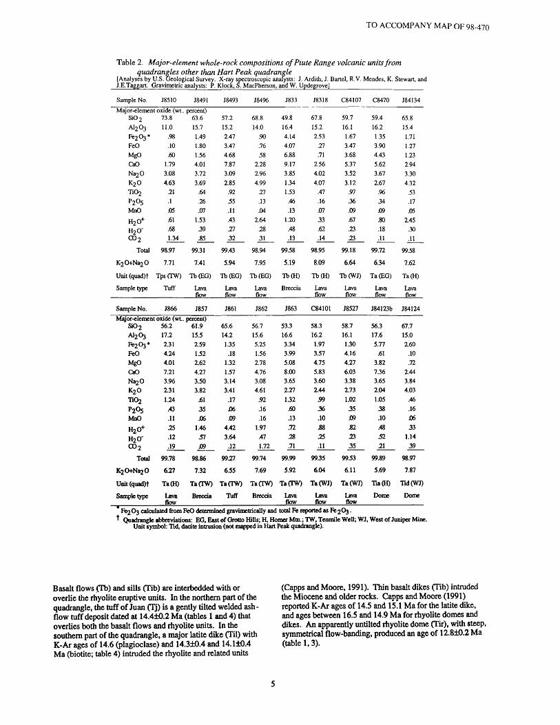
Table 2. Major-element whole-rock compositions ofPiute Range volcanic units from quadrangles other than Hart Peak quadrangle
[Analyses by U.S. Geological Survey. X-ray spectroscopic analysts: J. Ardith, J. Bartel, R.V. Mendes, K. Stewart, and J.E.Taggart. Gravimetric analysts: P. Klock, S. MacPherson, and W. Updegrove]
Sample No. J8510
Major-element oxide (wt.. SiO 2 73.8A12 O3 11.0Fe2 O3*FeOMgO CaONa20 K20
P2°5MnOH2O+
CO 2
Total
K2CMi^O
Unit (quad)t
Sample type
Sample No.
.98
.10
.60 1.793.08 4.63
21.1.05.61 .681.34
98.97
7.71
TpsCTW)
Tuff
J866
Major-element oxide (wt. SiO 2 56.2 A12 O3 17.2Fe^*
FeOMgO CaONa2 O K2 O T102P205 MnOH20+ H2O"
CO 2
Total
K2O+Na2O
Unit (quad)t
Sample type
2.31 4.244.01 7.213.96 131 1.24
.43 .1125 .12 .19
99.78
6.27
Ta(H)
Lava flow
J8491
percent) 63.615.71.491.801.56 4.013.72 3.69
.64
.26
.071.53 39.85
99.31
7.41
Tb(EG)
Lava flow
J857
percent) 61.9 15.52.59 1.522.62 4.273.50 3.82
.61 35 .06
1.46 57 .09
98.86
732
Ta(TW)
Breccia
J8493
57.2 15.22.473.474.68 7.873.09 2.85
.9255.11.43 2732
99.43
5.94
Tb(EG)
Lava flow
J861
65.6 14.21.35
.18132 1.573.14 3.41
.17 J06 .09
4.42 3.64
.12
9927
655
Ta(TW)
Tuff
J8496
68.8 14.0
.90
.7658
2.282.96 4.99
.27
.13
.042.64
.2831
98.94
7.95
Tb(EG)
Lava flow
J862
56.7 15.65.25 1.562.78 4.763.08 4.61
.92
.16
.161.97
.47 1.72
99.74
7.69
Ta(TW)
Breccia
J833
49.8 16.44.144.076.88 9.173.85 1.34 1.53
.46
.131.20
.48
.13
99.58
5.19
Tb(H)
Breccia
J863
53.3 16.6334 3.995.08 8.003.65 2.27 1.32
.60
.13
.72 28 .71
99.99
5.92
TaCTW)
Lava flow
J8318
67.8 15.22.53
.27
.71 2.564.02 4.07
.47
.16
.07
.33
.62
.14
98.95
8.09
Tb(H)
Lava flow
C84101
58.3 16.21.97 3.574.75 5.833.60 144
59 36 .10.88 25 .11
9935
6.04
Ta(WJ)
Lava flow
C84107
59.7 16.11.673.473.68 5.373.52 3.12
.97
.36
.09
.67
.2323
99.18
6.64
Tb(WJ)
Lava flow
J8527
58.7 16.11.30 4.164.27 6.033.38 173 1.02 35 .09.82 23 35
9953
6.11
Ta(WJ)
Lava flow
C8470
59.4 16.21.353.904.43 5.623.67 2.67
.9634.09.80 .18.11
99.72
6.34
Ta(EG)
Lava flow
J84123b
563 17.65.77
.613.82 7.363.65 2.04 1.05 38 .10.48 52 21
99.89
5.69
Tia(H)
Dome
J84134
65.8 15.41.711.271.23 2.943.30 4.32
53.17.05
2.45 30.11
9958
7.62
Ta(H)
Lava flow
J84124
67.7 15.0160
.10
.72 1443.84 4.03
.46
.16 J0633
1.14 39
98.97
7.87
Tid(WJ)
Dome
Fe2 O3 calculated from FeO determined gravimetrically and total Fe reported as Fe 2O3.Quadrangle abbreviations: EG, East of Grotto Hills; H, Homer Mtn.; TW, Tenmile Well; WJ, West of Juniper Mine.
Unit symbol: Tid, dacite intrusion (not mapped in Hart Peak quadrangle).
Basalt flows £Tb) and sills (Tib) are interbedded with or overlie the rhyolite eruptive units. In the northern part of the quadrangle, the tuff of Juan (Tj) is a gently tilted welded ash - flow tuff deposit dated at 14.4±0.2 Ma (tables 1 and 4) that overlies both the basalt flows and rhyolite units. In the southern part of the quadrangle, a major latite dike (Til) with K-Ar ages of 14.6 (plagioclase) and 14.3±0.4 and 14.1±0.4 Ma (biotite; table 4) intruded the rhyolite and related units
(Capps and Moore, 1991). Thin basalt dikes (Tib) intruded the Miocene and older rocks. Capps and Moore (1991) reported K-Ar ages of 14.5 and 15.1 Ma for the latite dike, and ages between 16.5 and 14.9 Ma for rhyolite domes and dikes. An apparently untilted rhyolite dome (Tir), with steep, symmetrical flow-banding, produced an age of 12.8±0.2 Ma (table 1,3).

TO ACCOMPANY MAP OF 98-470
The rhyolite units (Tr, Tts) are thickest in the western part of the Castle Mountains, where domes are most abundant. The greatest thickness (about 1 km) is found 2 km north of Hart town site (SW ] /4) sec. 13, T. 14 N., R. 17 E.). Less than 2 km to the east (NE ] /4 , sec. 18,T. 14N..R. 18E.), the Castle Mountains rhyolite sequence is represented by a thin (0.1 km) rhyolite tuff unit (Tts) that overlies Early Proterozoic gneiss and is overlapped in turn by basaltic lava of the Piute Range. The main exposures of the rhyolite unit (Tr) in the east part of the map area are eruptive and intrusive breccia that form the marginal carapace of a dome; for example, near Lewis Holes, Nevada (sec. 15, T. 30 S., R. 62 E.). Related dikes trend northeast, parallel to both a major fault zone and to the trend of domes on the west side of the Castle Mountains.
Abundant zones of alteration, including silicified and gold-bearing veinlets, are present in tuff and breccia of the rhyolite and related units near Hart, which supported gold mining in the early 20th century. Pits in altered tuff (NW %, SW 1 /4 ,sec. 24, T. 14 N., R. 17 E.) have yielded china clay (kaolinite) since World War II. The Viceroy Gold Corporation began development of a major heap-leach gold mine south of the kaolinite pits (N 1 /2 ,sec. 25, T. 14 N., R. 17 E.), in 1991.
Piute Range Volcanic RocksThe Piute Range volcanic sequence in the Hart Peak
quadrangle is composed predominantly of a unit of stubby andesite and trachyandesite flows and flow breccia (Ta); this unit is interleaved with and locally overlain by basalt, trachybasalt, and basaltic andesite flows and flow breccia (Tb). Both units include sparse dacite and rhyolite flows, as well as gravel-filled channels (Tg). Both units may be interbedded with a horizon of white air-fall tuff (Tpr). The predominantly andesitic flows (Ta) contain dikes and domes of the same lithology (Tia); the largest dome in the quadrangle, about 300 m in diameter, is hornblende trachyandesite in composition. Samples of units Ta and Tb obtained from all parts of the Piute Range (fig. 2, tables 4 and 5) have produced substantial age ranges: Ta, 19.8 to 8 Ma; Tb, 12.2 to 10.7 Ma. A rhyolitic flow within unit Tb yielded an age of 13.3 Ma. Including the silicic types, most rocks of the Piute Range are generally dark colored, markedly in contrast with coeval leucocratic rhyolite units exposed in the Castle Mountains.
YOUNGER TERTIARY SEDIMENTARY ROCKSSilicified rhyolite breccia of the rhyolite tuff, flows, and
intrusive rocks unit (Tr) grades upward into a horizon of bentonitic clay in the area of Hightower Well (sec. 14, T. 14 N., R. 17 E.) in the western Castle Mountains. This probable paleosol (R.E. Reynolds, oral commun., 1994) is overlain by crystal-rich sandstone that contains lenses of coarse gravel. The sandstone coarsens upsection to predominantly gravel with pebble- and cobble-size clasts and very little matrix (Tg); this gravel unit can be mapped continuously from the area of Hightower Well westward into the Castle Peaks quadrangle, where basalt lava flows and a silicified rhyolite tuff are interbedded in the basal part of the gravel unit. Clasts of the gravel unit are mostly Early Proterozoic gneiss and granite, Paleozoic limestone and marble, and Mesozoic granite. The gravel unit generally contains a low proportion of volcanic clasts, although horizons composed entirely of clasts derived from the Castle Peaks volcanic sequence are found locally. Similar deposits of the gravel unit fill channels developed on
or within flows in the Piute Range. A younger gravel unit (QTe) of similar desctintion. conformable with *n<\ W«]],,indistinguishable from the Tertiary gravel unit, is also mapped in the area between the Castle Peaks and Castle Mountains in the Hart Peak quadrangle.
QUATERNARY ALLUVIAL AND PLAYA DEPOSITSSeveral generations of unsorted alluvial-fan and stream-
channel deposits are found throughout the ranges and intervening valleys. Older fan deposits (Qoa) are highly dissected and have surfaces that have been stripped of soil, exposing calcified zones. Alluvium of intermediate age can be distinguished morphologically, either as fan (Qiaj) or channel deposits (Qia2). In the Piute Range (but not in Hart Peak quadrangle) the an older and younger generation of each intermediate unit can be distinguished by truncation and surface erosion. The intermediate age unit is less eroded than the older fan unit and has featureless surfaces and thick but poorly defined soil profiles. The intermediate-age channel deposits have bar-and-swale surfaces, but also may show significant soil development. The older fan and channel deposits are overlain by alluvium of present-day active channels (Qya).
STRUCTURE
DIPS AND UNCONFORMITIES
Exposures of lower and middle Miocene volcanic and sedimentary rocks in the northwest corner of the map area (easternmost Castle Peaks), dip gently southeast toward the Castle Mountains, whereas the thick sequence of Miocene volcanic units of the northwestern Castle Mountains generally dip 30° to 40° W. toward the Castle Peaks. Miocene flows of the Piute Range mostly dip W. 15° or less in the Hart Peak quadrangle.
East of Hart town site in the southern part of the Castle Mountains (NW ! /4 , sec. 19, T. 14 N., R. 18 E.), the Peach Springs Tuff and a lower unit of mafic flows and breccia (Tern) have measured dips as much as 65° W; farther to the north, the Peach Springs Tuff dips around 40° W. In both the southern and northern parts of the Castle Mountains, the overlying rhyolite units (Tjw, Tr, Tts, Tj) generally dip more moderately (between 45° and 25° W.). Injection of domes locally steepened or reversed dips of intruded strata and also deflected the strike of units (for example, units Tlss and Tjw exposed north of small dome in the middle of cross section A- A 1).
South and west of Quail Spring (SW l /4 , sec. 4, T. 14 N., R. 18 E.), mafic flows of the volcanic flows and breccia of the Castle Mountains (Tcm) unit dip gently southward. In this part of the map area, the variations of dip and strike in this unit resemble the nose of an anticlinal fold with northeast- trending hinge line and southwest plunge (Turner and Glazner, 1990).
No unconformities of greater than local scale can be distinguished within any of the Miocene volcanic sequences in the Hart Peak or nearby quadrangles. However, local buttress and angular unconformities between domes and eruptive units are common within the rhyolite tuff, flows, and intrusive rocks (Tr) unit in the Castle Mountains and basalt and andesite units (Tb, Ta) in the Piute Range.

TO ACCOMPANY MAP OF 98-470
Table 3. Major-element whole-rock compositions of volcanic units in Piute Range, within Hart Peak quadrangle
Sample No. C8429
Major-element oxide (wt. SiO 2 58.5A12 O3Fe2 O3*FeOMgOCaONa2 OK20TiC^P2°5MnOH20+ H2O'
CO 2
Tola 1
K2 O+Na2O
Unit
Sample type
17.14.301.032.455.523.812.91
.9737.08.87
1.18 .09
99.18
6.72
Ta
Lava flow
C8433§
percent) 61.916.71.432.602.054.233.643.74
.77
.30
.061.57
.30
.09
99.38
7.38
Ta
Lava flow
C8439§
49.316.95.223.696.409.423.511.281.54
.58
.141.14
.43
.07
99.62
4.79
To
Lava flow
C8442
62.216.81.512.562.094.273.613.88
.78
.30
.061.10
.19
.16
99.51
7.49
Ta
Lava flow
C8486
75.212.41.24
.1636.94
3.404.47
22.06.03.46 37 .10
99.41
7.87
Tir
Dome
J8481
60173.291.292.605.363.693.21
.83
.34
.07
.84 36 .48
99.36
6.9
Ta
Lava flow
J8484
61.616.94.21
351.734.533.893.48
.8432.06.51 .79 .10
99.31
7.37
To
Lava flow
J84109a
62.116.41.542.422.004.123.523.78
.7729.06
1.72 33 .10
99.15
73
Ta
Lava flow
J84CMP
53.716.92.524.775.567.883.661.861.37
.43
.12
.45 38 .24
99.84
5.52
To
Lava flow
* Dated sample; age given in table 4.* Fe2 03 calculated from FeO determined gravimetrically, and total Fe reported as Fe 2Q3.
Table 4. Isotopic ages of volcanic units in Hart Peak quadrangle[na, not applicable]
Sample No. Latitude (N.)
Longitude Location* (W.)
Unit Material dated ,%<> (wtpct)
**#I0'u
(mol/g)
Percent <%*
Calculated age(Ma)§
Assigned age (Ma)
Castle Mountains
138Tt
J901
J903137Tt**
62Tt«*
t** 178T 1
J8446¥
35° 21' 51"
35° 16' 54"
35° 16' 56"
35° 21-27"
35° 21' 55"
35° 19' 13"
35C 17'49"
115° 04' 00"
115° 05' 24"
115° 05* 32"
115° 0506"
115° 03' 22"
115° 03' 50"
115° 04' 23"
7
14
15
5
4
2
3
Tir
Til
Til
Tj(basal)
Tjw
Tps
Tps
Sanidine
Plagioclase,biotite
Biotite
BiotiteSanidine,
biotiteSanidine,
biotite
Sanidine
10.06.909
8.52
8.44
8.628.828.689.378.66
na
1.85
1.911.76
1.71
1.792.072.022.362.32
na
40.145.149.9
48.8
63.558.272.450.765.7
na
11814.614.3
14.1
14.416.2
. 16.117.518.5
na
12.8±0.2
14.4±0.4
14.4±0.2
16.1±0.4
18.5±0.5
18.79±0.04
Piute Range
*** C8433*C8439***
35° 17 35"
35° 19' 12"
115° 02' 15"
115° 01' 44"
13
11
Ta
To
Whole rock
Whole rock
3.85
1.33
4.84.1
2.042.02
46.546.8
35.236.7
8.647.41
10.6010.70
8.0±0.6
10.7±0.3
Sample location plotted on figure 2 and map.§ K-Ar ages calculated using the constants for the radioactive decay and abundance of K recommended by the International Union of Geological Sciences
Subcommission on Geochronology (Steiger and Jfiger, 1977). These constants are: Xg = 0.580 x 10 yr~*, fyj = 4.962 x lO'^yr"1 , and ̂ VKtotal =1.167 x 10⁴ mol/mol.
t Conventional K-Ar age, J.E. Spencer, analyst (Turner, 1985). Ages of sample 62T and 178T previously published by Turner and Glazner (1990).Rock composition given in table 1
¥ ^Ar/^Ar laser fusion age, B.D. Turrin, analyst, dted by Nielson and Nakata (1993). * Conventional K-Ar age, J.K. Nakata, analyst, previously published by Nielson and Nakata (1993).
TO ACCOMPANY MAP OF 98-470
FAULTS
The Castle Mountains are divided into north and south parts by faults in the central part of the quadrangle (sec. 8, T. 14 N., R. 18 E.) with steep dips and west- to northwest- strikes. These faults cut the lower volcanic section and exposures of underlying migmatitic gneiss. Most other faults in the Castle Mountains strike north-northeast and west- northwest and dip steeply to the east, although low-angle normal faults in the lower part of the Castle Mountains volcanic sequence (for example, near Jacks Well, sec. 4, T. 30 S., R. 62 E.) have moderately low dips to the east. High-angle faults generally cut low-angle faults, although one major high- angle, oblique-slip fault north and northeast of Jacks Well turns into a low-angle fault as the strike changes from east to north (Turner, 1985). Faults within Piute Range rocks generally trend north and northeast, and all apparently have steep dips.
Steep northeast-striking normal faults that crop out in the Castle Peaks, west of the quadrangle, drop basement gneiss units and overlying Miocene rocks down to the northwest (Miller and others, 1986; Thompson, 1990). The relation between those faults and faults that cut Castle Peaks rocks in the northwest corner of the quadrangle is unknown. Reconstruction of Cretaceous granite plutons and faults south of the New York Mountains (fig. 1) suggests about 10 km of strike slip offset on the northeast-striking Cedar Canyon fault (D.M. Miller, oral commun., 1995), which also shows dip slip displacement of early Miocene volcanic units down to the southeast (Miller, 1995a).
If the inferred magnitude of strike slip offset on the Cedar Canyon fault is correct and of Miocene age, projected traces of related faults within early Miocene deposits and underlying rocks in the area of the Hart Peak quadrangle may also have strike-slip offsets. We therefore have tentatively inferred a fault (unmapped; represented on cross sections), now covered by middle Miocene and younger deposits, to explain the differences between the Castle Peaks and Castle Mountains, both of exposed Early Proterozoic rocks and of the lower Miocene volcanic units. This inferred fault would be found in the area where the oppositely-directed dips of the Castle Peaks and Castle Mountains (see above) must intersect.
A zone of alteration and severe brecciation in the area of Hightower Well (sec. 14, T. 14 N., R. 17 E.) may represent shearing by normal faults that formed during Miocene extensional tectonism and associated volcanism (Capps and Moore, 1991). These faults define crustal blocks in the Castle Mountains area that were dropped down to the southwest, thus creating a subsiding half-graben basin which ponded drainages as indicated by the unit of lacustrine deposits and collected eruptive materials. Faults on the west side of the Piute Range may also have a large local displacements. Other fault displacements appear relatively small, however, and the map area appears less extended than the neighboring Eldorado and Black Mountains of the Lake Mead region (Anderson, 1971; Anderson and others, 1972; Bohannon, 1979; Faulds and others, 1990).
INTERPRETATION
STRATIGRAPHIC RELATIONS BETWEEN MIOCENE SEQUENCES
The locally erupted volcanic sequences in the Hart Peak quadrangle all formed after deposition of the Peach Springs Tuff at about 18.5 Ma. All Miocene deposits older than 12.8 Ma are tilted (Turner and Glazner, 1990). The timing of
volcanic activity and deformation coincides with major episodes of extensional faulting in the nearby Black and El Dorado Mountains of Nevada (fig. 1; Faulds and others, 1994). Both volcanic vents for the Castle Mountains flows and ejecta and feeder dikes of the Piute Range flows are abundant in the quadrangle. Feeder dikes for capping andesitic flows (Tap) in the Castle Peaks also are common but feeders for the underlying units are less conspicuous; the coarse clast sizes of the Castle Peaks' volcanic breccia (Tbr) deposit indicate that the sources must have been local intrusive and eruptive domes.
The volcanic sequences of the Castle Mountains and Piute Range formed coevally, for the most part, in close proximity on an irregular topography. The relation between the Castle Peaks and Castle Mountains volcanic sequences is less clear. Ages determined on volcanic units from all parts of the Piute Range bracket those of the Castle Mountains volcanic sequence, but mafic and intermediate-composition eruptive rocks of the Piute Range in the Hart Peak quadrangle are age equivalents of only the upper volcanic and intrusive units (Tts, Tr, Tb, Til, Tir) of the Castle Mountains. The tentative correlation of the tuff of Barn well, a part of the capping andesite flow (Tap) unit in the Castle Peaks, with the 17.8-Ma tuff of Wild Horse Mesa at the west side of Lanfair Valley (fig. 1), suggests that the entire Castle Peaks volcanic sequence may be coeval with Castle Mountains units Tern and Tlss, both of which are older than 16 Ma.
MIOCENE DEPOSITIONAL ENVIRONMENTS
Castle Mountains DepositsThe total thickness of major rhyolite units (Tts, Tr)
changes from about 1 km near Hart town site to less than 100 m near Quail Spring, about 6.5 km to the northeast. In the area of Quail Spring the lowermost Miocene units, principally the Peach Springs Tuff and basal volcanic flows and breccia (Tcm), have tilts of as much as 65°, whereas overlying units have uniformly moderate dips (30° to 40°). The abrupt variation in thickness, as well as the lower proportion of rhyolitic rocks in the Castle Peaks area, west of the Castle Mountains, indicate that the rhyolite units accumulated in a half-graben basin that shoaled to the east In addition, the steeper dips of the older units (Tps, Tcm) show that they underwent a greater amount of tilting than the overlying voluminous rhyolite eruptive units, substantiating the inference that the younger units were deposited as the basin subsided and deepened.
We agree with interpretations of Capps and Moore (1991), that the southern part of the Castle Mountains is a volcano-tectonic depression created by the eruption of rhyolite and tuff units equivalent to units Tr and Tts. We also agree with Capps and Moore (1991) who located the western edge of this depression at the zone of sheared and silicified volcanic rocks near Hightower Well. We do not concur with Capps and Moore's (1991) interpretation that the volcano- tectonic depression is limited to the southern part of the Castle Mountains, however. The basis for this disagreement is: 1) the volume of rhyolite eruptive units (Tts, Tr) in the northern part of the quadrangle is about equivalent to that in the area near Hart and Hightower Well, 2) domes (Tir) are nearly as abundant north of Hightower Well, although not as large or as concentrated as farther south, and 3) the generally north trending alignment of latite and rhyolite intrusions shows no measurable change from the southern to the northern Castle Mountains. The zone of shearing and silicification does not

TO ACCOMPANY MAP OF 98-470
Table 5. Isotopic ages of volcanic units of Castle Peaks and Piute Range, in areas other than Hart Peak quadrangle
Conventional K-Ar ages
Sample No.
S901***
J8493***
J84%***
C8470+**
J866***
Jooz
***J863
Sample No.
J9081
S901
Latitude (N.)
35° 19' 33"
35° 13' 00"
35° 14' 00"
35° 12' 00"
35° 05' 31"
35° 16' 18"
35° 16' 18"
Latitude (N.)
35° 20' 56"
35° 19' 33"
Longitude Location* Unit Material dated KjO ^^rad j<?rcent W-> (quadt) (wtpct) UJ-Honol/g) ^tad
115° 13' 55" 17 Tbr(CP) Biotite 8.54
11 5° 01' 50" 6 Tb(EG) Whole rock 2.95
115° 01' 35" 10 Tb(EG) Biotite 8.84
11 5° 01' 06" 8 Ta(EG) Whole rock 2.74
114° 58' 23" 1 Ta(H) Whole rock 1.5
114° 59' 02" 9 TaCTW) Whole rock 3.56
11 4° 59' 43" 12 Ta(TW) Whole rock 2.40
40Ar/39Ar total fusion ages[John K. Nakata, analyst]
Longitude Location* Unit *>. . 37 A . 36 A . ^Ar ^ (Material (q^ f) ^ 39^ 39^' («>tes)
dated) Ar Ar Ar
115° 07' 29" 16 Tcp(CP) 8.01 .65 .015 4.7x10⁻¹⁴(Sanidine)
115° 13' 55" 17 Tbr(CP) 12.3 2.01 .0327 2.05x10⁻¹⁴(Sanidine)
1.8
5.135.28
1.71.7
4.75.4
4.3
5.846.88
3.353.72
Pet ^Arnri
46.0
23.0
67.967.068.038.355.5
63.578.4
75.5
73.471.4
56.863.6
Pet 39 Ca
.04
.13
Calculated age (Ma) §
14.7
12.0412.38
13.3113.40
11.8513.60
19.82
11.3613.4
9.6610.74
Pet K/Ca36 Ca
12 .75
1.65 .24
Assigned age (Ma)
14.7±0.4
12.2±0.3
13.3±0.3
12.710.8
19.8±0.5
12.4+1.4
10.2+0.7
Age (Ma)
21.4±5.5
17.5±10.4
Location plotted on figure 2.Quadrangle abbreviations: EG, East of Grotto Hills; H, Homer Mtn.; TW, Tenmile Well; CP, Castle Peaks.K-Ar ages were calculated using the constants for the radioactive decay and abundance of K recommended by the International Union of Geological Sciences
= 4-962 x lO" . and = 1.167 xSubcommission on Geochronology (Steiger and Jager, 1977). These constants are: ^ = 0.580 x lO'y 104 mol/mol
Conventional K-Ar age, previously published by Nielson and Nakata (1993); data above includes one corrected sample number and two corrected longitudes. Rock composition given in table 2.
crop out in the northern part of the Castle Mountains, however, possibly due to a lower volatile content of late intrusions. The west- and northwest-striking faults in the central Castle Mountains likely define an intrabasinal boundary.
Piute Range DepositsThe change in elevation of the contact of basal
Miocene rocks on Early Proterozoic rocks in the Hart Peak and adjacent quadrangles, shows that faults must offset pre-Miocene basement rocks 300 m to 500 m down to the east. Geophysical data also support the interpretation that Piute Range faults with north to northeast strikes and apparently steep dips in the east part of the Hart Peak quadrangle have displacements that are down to die east. These faults likely are members of a fault system that formed the western boundary of an eastern volcano - tectonic half-graben basin. In the eastern basin, Piute Range lavas accumulated coeval with eruption of Castle Mountains rhyolite ejecta and domes hi the western basin.
The presence of adjacent, coeval volcano- tectonic basins is shown in aeromagnetic data (fig. 4; U.S. Geological Survey, 1983). A positive magnetic anomaly with northeast trend in the northeastern part of the quadrangle is generated by exposed and near-surface gneiss of the Castle
115*0r30* Hart Peak 115'TenmileWeH
35' or30* E. of Grotto Hills W. of Juniper Mine
Figure 4. Aeromagnetic survey of Hart Peak quadrangle and adjacent quadrangles. Magnetic values in gammas; contour interval 50 gammas. Light shading depicts outcrops of Tertiary and older rocks; darker shading shows outcrops of Early Proterozoic migmatitic gneiss (Xmg) unit in Hart Peak quadrangle. Symbols: .Hart; A, Quail Spring. Data from U.S. Geological Survey (1983).
TO ACCOMPANY MAP OF 08470
Mountains. South of Hart town site, a negative magnetic anomaly trends east, and trends northeast over the westernmost outcrops of Piute Range flows (fig. 4). Immediately east of Quail Spring, the steep magnetic gradient between these positive and negative anomalies trends northeast; this gradient probably corresponds to a steep contact between the migmatitic gneiss (Xmg) unit, including intrusive rhyolite domes and dikes (Tir) on the northwest side, and relatively less magnetic volcanic rocks of the Piute Range, which must thicken abruptly on the southeast side. That abrupt thickening most likely is due to the fault or faults that dropped the basement rocks down to the east while the Piute Range volcanic units were erupted. Gravity measurements (Mariano and others, 1986) similarly support offset of the basement rocks down to the east by a fault (or faults) that strikes parallel to the west side of the Piute Range.
The apparent buttress contact between the migmatitic gneiss (Xmg) unit and the volcanic flows and breccia of the Castle Mountains (Tcm) unit (cross section B-B*) suggests that the Piute Range basin began forming toward the end of eruption of unit Tcm in the Castle Mountains. This supposition is supported by the abundance and continuity of rhyolite dikes and domes that intruded that contact, and which crop out from south of Quail Spring to north of Lewis Holes. Most of the intrusions appear to postdate fault movements, except for one in the area southwest of Quail Spring in the central Castle Mountains (E l /2 , NW l /4 , and W l /2 , NE l /4 , sec. 8, T. 14 N., R. 18 E.) that is pervasively sheared by northwest-striking faults.
Fault-Basin Origin of the So-Called Castle Mountains Anticline
The outcrop pattern that has been interpreted as an anticline in the Castle Mountains (Bingler and Bonham, 1973; Turner and Glazner, 1990) probably is not due to compressional folding, but more likely is an artifact of differential subsidence during volcanic eruptions that was driven by regional extensional faulting in the nearby Eldorado Mountains (Faulds and others, 1990,1994). As noted above, formation of the volcano-tectonic basin of the Castle Mountains produced the westerly dips of Miocene rocks, and most dips of rocks in the Piute Range are also to the southwest.
Very low southerly and easterly dips (toward the Piute Range) are measured on volcanic flows and breccia of the Castle Mountains (Tcm) unit of the lower part of the Castle Mountains volcanic sequence, in a belt that extends from southwest of Quail Spring to Lewis Holes. Units Tcm, Tts, and Tvl at the south end of this belt (NE I i4 , sec. 18, T. 14 N., R. 18 E.) are very thin and directly overlie migmatitic gneiss; the unit and basal contact dip very gently to the southeast beneath olivme-bearing basaltic flows (Tb). The section is truncated to the east by a north-striking fault. This attenuated section of gently south- or east-dipping units probably does not constitute an east-dipping fold limb, but more likely is the remnant of a thinner accumulation of volcanic units on a ridge of pre-Tertiary basement rocks. The basement ridge separated the western and eastern volcano-tectonic depressions of the Castle Mountains and Piute Range, respectively (Nielson and others, 1993).
POST-VOLCANIC DEPOSITSUpper Miocene sandstone and gravel deposits (Tg)
overlie volcanic rocks of the Castle Peaks and Castle Mountains on a distinct angular unconformity. The basal part
of the gravel deposits unit generally is derived from gneiss and granite of the basement complex. Thus, in Miocene time as today, high elevations at the heads of drainages provided detritus composed mostly of pre-Tertiary rocks. The local concentrations of volcanic clasts from the uppermost part of the Castle Peaks volcanic sequence indicate that some of the Castle Peaks andesite flows (Tap) also occupied high topographic positions and that erosion of the unit began in late Miocene time.
Depositional and structural relations of the gravel deposits unit (Tg), exposed in the Hart Peak and adjacent quadrangles, support continued episodes of faulting in Pliocene or latest Miocene time. Clasts of gray, chert-bearing Paleozoic limestone are present in the gravel deposits near Hightower Well and southeast of Hart town site, in association with Mesozoic granitic rocks. These clasts probably were derived from the area of the Mescal Range and Ivanpah Mountains, although clasts of some Mesozoic granite types may have come from sources in the southern New York Mountains.
Possible drainage routes between the Mescal Range and Ivanpah Mountains and Castle Peaks-Castle Mountains area are presently obstructed by the topographic barrier of the New York Mountains. Also, present-day drainages emerging from the southern New York Mountains are deflected by the western flank of the Castle Mountains and flow southeast, opposite to the direction required for transport of clasts into areas where the Tertiary gravel unit is exposed in the Castle Peaks and Castle Mountains (Nielson, 1995).
These relations all show that the topographic barriers must postdate deposition of the Miocene gravel unit (Miller, 1995b; Nielson, 1995); thus, the earliest time that the topographic barriers could have formed is late Miocene. The topographic barriers probably were created by late Tertiary faulting episodes that caused relative uplift of the mountain ridges or relative subsidence of the valleys. Later faulting events may have continued, providing wide exposure of basement rocks and generating sources of detritus that was shed into the drainage systems. Those surficial deposits are represented by the undeformed younger gravel unit (QTg), which is conformable with and locally indistinguishable from, the older Quaternary alluvium (Qoa).
Another topographic barrier was formed by the linear western boundary of Piute Range flows, which blocked Lanfair Valley drainages after the cessation of volcanism in the late Miocene. By early Pleistocene, thick playa deposits
L accumulated at this buttress (Nielson, 1995). Subsequently, cross-cutting drainages for example, the east-trending canyon leading to the end of Old Homestead Road (sees. 4- 16. T. 14 N., R. 18 E.; fig. 2) were superimposed on the Piute Range. Immediately south of the Hart Peak quadrangle, some streams of the western Piute Range form the headwaters of Piute Gorge, an east-trending superimposed canyon of the southern Piute Range. These streams are prevented from merging with the major south-flowing washes of eastern Lanfair Valley by a low terrace of intermediate alluvium (Qia i) units. The terrace was formed by incision of the intermediate alluvium unit, which could another indication of continued faulting, and relative offset of valleys and mountain ridges, after Miocene time (Nielson, 1995).
REFERENCES CITEDAnderson, R.E., 1971, Thin skin distension in Tertiary rocks
of southeastern Nevada: Geological Society of America Bulletin, v. 82, no. 1, p. 43-58.
10

TO ACCOMPANY MAP OF 98-470
Anderson, R.E., Longwell, C.R., Armstrong, R.L., andMarvin, R.F., 1972, Significance of K-Ar ages of Tertiary rocks from the Lake Mead region, Nevada-Arizona: Geological Society of America Bulletin, v. 83, no. 2, p. 273-288.
Balkwill, H.R., 1964, Geology of the central New YorkMountains, California; Los Angeles, University of Southern California, M.S. thesis, 93 p.
Beckerman, G.M., Robinson, J.P., and Anderson, J.L., 1982, The Teutonia batholith: a large intrusive complex of Jurassic and Cretaceous age in the eastern Mojave Desert, California, in Frost, E.G., and Martin, D.L., eds., Mesozoic-Cenozoic tectonic evolution of the Colorado River region, California, Arizona, and Nevada: San Diego, California, Cordilleran Publishers, p. 205-221.
Bingler, E.G., and Bonham, H.F., 1973, Reconnaissance geologic map of the McCullough Range and adjacent areas, Clark County, Nevada: Nevada Bureau of Mines and Geology Map 45, scale 1:125,000.
Bohannon, R.G., 1979, Strike-slip faults of the Lake Mead region of southern Nevada, in Armentrout, J.M., Cole, M.R., and Terbest, Harry, Jr., eds., Cenozoic paleogeography of the western United States: Pacific Section, Society of Economic Paleontologists and Mineralogists, Pacific Coast Paleogeography Symposium 3, p. 129-140.
Burchfiel, B.C., and Davis, G.A., 1977, Geology of theSagamore Canyon-Slaughterhouse Spring area, New York Mountains, California: Geological Society of America Bulletin, v. 88, p. 1623-1640.
Capps, R.C., and Moore, J.A., 1991, Geologic settrng of mid- Miocene gold deposits in the Castle Mountains, San Bernardino County, California and Clark County, Nevada, in Raines, G.L., Lisle, R.E., Shafer, R.W., and Wilkinson, W.H., eds., Geology and ore deposits of the Great Basin: Geological Society of Nevada, Symposium Proceedings, v. 2, p. 1195-1219.
Cox, K.G., Bell, J.D., and Pankhurst, R J., 1979, Theinterpretation of igneous rocks: London, George Alien and Unwin, 450 p.
Faulds, J.E., 1993, Miocene stratigraphy of the central Black Mountains, northwestern Ariz.: variations across a major accommodation zone, in Sherrod, D.R., and Nielson, J.E., eds., Tertiary stratigraphy of highly extended terranes, California, Arizona, and Nevada: U.S. Geological Survey Bulletin 2053, p. 37-43..
Faulds, J.E., Cans, P.B., and Smith, E.I., 1994, Spatial and temporal patterns of extension in the northern Colorado River extensional corridor, northwestern Arizona and southern Nevada [abs.]: Geological Society of America Abstracts with Programs, v. 26, no. 2, p. 51.
Faulds, J.E., Geissman, J.W., and Mawer, C.K., 1990,Structural development of a major extensional accommodation zone in the Basin and Range province, northwestern Arizona and southern Nevada: implications for kinematic models of continental extension, in Wernicke, B.W., ed., Basin and Range extensional tectonics near the latitude of Las Vegas, Nevada: Geological Society of America Memoir 176, p. 37-76.
Glazner, A.F., Nielson, J.E., Howard, K.A., and Miller, D.M., 1986, Correlation of the Peach Springs Tuff, a large-volume Miocene ignimbrite sheet in California and Arizona: Geology, v. 14, no. 10, p. 840-843.
Gusa, Sharon, Nielson, J.E., and Howard, K.A., 1987, Heavy mineral suites confirm the wide distribution of the Peach Springs Tuff in California and Arizona, USA: Journal of Volcanology and Geothermal Research, v. 32, no. 4, p. 343-336.
Hewett, D.F., 1956, Geology and mineral resources of theIvanpah quadrangle, California and Nevada: U.S. Geological Survey Professional Paper 275,172 p.
Longwell, C.R., 1963, Reconnaissance geology between Lake Mead and Davis Dam, Arizona-Nevada: U.S. Geological Survey Professional Paper 374-E, 51P-
Mariano, John, Helferty, M.G., and Gage, T.B., 1986,Bouguer and isostatic residual gravity maps of the Colorado River region, including the Kingman, Needles, Salton Sea, and El Centre quadrangles: U.S. Geological Survey Open-File Report 86-347, 7 sheets, scale 1:250,000.
McCurry, Michael, 1988, Geology and petrology of theWoods Mountains volcanic center, southeastern California: implications for the genesis of peralkaline rhyolite ash flow tuffs: Journal of Geophysical Research, v. 93, no. B12, p. 14,385- 14,855.
McCurry, Michael, Lux, D.R., and Mickus, K.L, 1995, Neogene structural evolution of the Woods Mountains volcanic center, East Mojave National Scenic Area, in Reynolds, R.E., and Reynolds, Jennifer, eds., Ancient surfaces of the east Mojave Desert: San Bernardino County Museum Association Quarterly, v. 42 no. 3, p. 75-80.
Medall, S.E., 1964, Geology of the Castle Mountains,California: Los Angeles, University of Southern California, M.S. thesis, 107 p.
Miller, D.M., 1995a, Characteristics, age, and tectonic implications of the Mid Hills pediment, in Reynolds, R.E., and Reynolds, Jennifer, eds., Ancient surfaces of the east Mojave Desert: San Bernardino County Museum Association Quarterly, v. 42 no. 3, p. 69-74.
Miller, D.M., 1995b, Tectonic implications of a middleMiocene paleovalley, northeastern New York Mountains, California, in Reynolds, R.E., and Reynolds, Jennifer, eds., Ancient surfaces of the east Mojave Desert: San Bernardino County Museum Association Quarterly, v. 42 no. 3, p. 155-159.
Miller, D.M., Frisken, J.G., Jachens, R.C., and Gese, D.D., 1986, Mineral resources of the Castle Peaks Wilderness Study Area, San Bernardino County, California: U.S. Geological Survey Bulletin 1713-A, 17 p.
Nielson, J.E., 1995, Cenozoic geologic framework andevidence for late Cenozoic uplift of the Castle Mountains, Castle Peaks, and Piute Range, California, in Reynolds, R.E., and Reynolds, Jennifer, eds., Ancient surfaces of the east Mojave Desert: San Bernardino County Museum Association Quarterly, v. 42 no. 3, p. 149-153.
Nielson, J.E., Frisken, J.G., Jachens, R.C., and McDonnell,J.R., Jr., 1987, Mineral resources of the Fort Piute
11

TO ACCOMPANY MAP OF 98-470
Wilderness Study Area, San Bernardino County, California: U.S. Geological Survey Bulletin 1713-C, 12 p.
Nielson, I.E., Lux, D.R., Dalrymple, G.B., and Glazner, A.F., 1990, Age of the Peach Springs Tuff, southeastern California and western Arizona: Journal of Geophysical Research, v. 95, no. Bl, p. 571-580.
Nielson, I.E., and Nakata, J.K., 1993, Tertiary stratigraphyand structure of the Piute Range, Calif, and Nev., in Sherrod, D.R., and Nielson, I.E., eds., Tertiary stratigraphy of highly extended terranes, California, Arizona, and Nevada: U.S. Geological Survey Bulletin 2053, p. 51-53.
Nielson, I.E., Turner, R.D., and Glazner, A.F., 1993, Tertiary stratigraphy and structure of the Castle Mountains and Castle Peaks, Calif, and Nev., in Sherrod, D.R., and Nielson, I.E., eds., Tertiary stratigraphy of highly extended terranes, California, Arizona, and Nevada: U.S. Geological Survey Bulletin 2053, p. 45-^9.
Reynolds, R.E., 1993, Erosion, deposition, and detachment: the Halloran Hills area, Calif., in Sherrod, D.R., and Nielson, I.E., eds., Tertiary stratigraphy of highly extended terranes, California, Arizona, and Nevada: U.S. Geological Survey Bulletin 2053, p. 21-24.
Spencer, I.E., and Turner, R.D., 1985, Geologic map ofHomer Mountain and the southern Piute Range, southeastern California: U.S. Geological Survey Miscellaneous Field Studies Map MF-1709, scale 1:24,000.
Thompson, S.M., 1990, Miocene volcanic rocks of the Castle Peaks area, New York Mountains, eastern San
Bernardino County, California: Los Angeles, California State University, Los Angeles, M.S. thesis, scale 1:24,000,71 p.
Turner, R.D., 1985, Miocene folding and faulting of anevolving volcanic center in the Castle Mountains, southeastern California and southern Nevada: Chapel Hill, University of North Carolina, M.S. thesis, 56 p.
Turner, R.D., and Glazner, A.F., 1990, Miocene volcanism, folding, and faulting in the Castle Mountains, southern Nevada and eastern California, in Wernicke, B.P., ed., Basin and Range extensional tectonics near the latitude of Las Vegas, Nevada: Geological Society of America Memoir 176, p 23-35.
U.S. Geological Survey, 1983, Aeromagnetic map of theKingman-Trona area, California: U.S. Geological Survey Open-File Report 83-663,2 sheets, scale 1:250,000.
Wells, R.E., and Hillhouse, J.W., 1989, Paleomagnetism and tectonic rotation of the lower Miocene Peach Springs Tuff: Colorado Plateau,,Arizona to Barstow, California: Geological Society of America Bulletin, v. 101, no. 6, p. 846-863.
Wooden, J.L., and Miller, D.M., 1990, Chronologic andisotopic framework for Early Proterozoic crustal evolution in the eastern Mojave Desert region, SE California: Journal of Geophysical Research, v. 95, no. B12, p. 20,133-20,146.
Young, R.A., and Brennan, W.J., 1974, Peach Springs Tuff:its bearing on structural evolution of the Colorado Plateau and development of Cenozoic drainage in Mohave County, Arizona: Geological Society of America Bulletin, v. 85, no. 1, p. 83-90.
12