u.s. army corps of engineers helena regulatory...
TRANSCRIPT

270 1 Prospect Avenue Brian Schweitzer, Governor PO Box 20 100 I
Helena MT 59620- 100 1
March 27,2006
Allan Steinle U.S. Army Corps of Engineers Helena Regulatory Office 10 West 15 '~ Street, Suite 2200 LEGISLATIVE ENVl RONMENTAL --
Helena, Montana 59626 POI-ICY OFFICE
Subject: Evaro to McClure Road NH 5-1(30)7 (Project 1 -US 93 Evaro to Polson) Control Number L744 Corps file number 2001-90-416
Dear Mr. Steinle:
The purpose of this application is to obtain an individual Section 404 permit for the implementation of Evaro to McClure Road referred to as Project 1 - US 93 Evaro to Polson. Project 1 begins in Evaro, Montana, at approximately US 93 reference post 6.5 and extends to approximately reference post 13.5 at McClure Road.
This application is the seventh of eight applications to be processed by your office for the projects related to the US 93 Evaro - Polson EIS.
Each permit application will include a ledger of comdor-wide impacts and comdor-wide mitigation (see attached table). The ledger presents the amount of wetland impact for the project for which MDT is seeking the permit and the amount of wetland mitigation for onsite mitigation projects as well as projects for which applications have already been submitted to your office. This ledger will track the amount of wetland impacts permitted and the amount of compensation available through onsite wetland mitigation. Remaining credits needed for the comdor will be obtained at CSKT Finley Creek property, formerly the Norgaard property.
Enclosed is a completed Joint Application and the following:
1) Summary Document - Includes project history; expected wetland impacts for the project comdor and measures to minimize those impacts; status of wetland mitigation for the project corridor; documentation of Endangered Species Act (ESA) compliance; and a list of relevant documentation previously provided to the Corps office
2) Project Area Topographic Map
3) Road Construction Plans
4) Section 404 Permit Permitting Plan Sheets 1 to 15 (dated 2/9/06)
An Equal Opportunity Employer

Allen Steinle March 27,2006 Page 2
If you have any questions about the materials contained in this application please contact Susan Kilcrease at (406) 523-5842 or me at (406) 444-0456. Due to the complexity of this project, this office is available to meet with your staff at your convenience to discuss and explain the project.
Sincerelv.
Engineering Section Supervisor Environmental Services Bureau.
Attachment & Enclosures
cc (with application on1 Dwane Kailey, I% .- MDT Acting Missoula District Administrator Paul R. Ferry, P.E. - MDT Highways Engineer Kent M. Barnes, P.E. - MDT Bridge Engineer Bonnie Steg - MDT Resources Section Supervisor Larry Urban - MDT Wetland Mitigation Coordinator Jake Goettle - MDT Erosion Control/Construction Permitting Engineer
cc (with all materials): Mike Durglo - CSKT - Water Quality Specialist Mary Price - CSKT WetlandIRiparian Ecologist Susan Kilcrease - MDT Project Development Engineer Environmental Services file

March 27,2006
Wetland impacts and mitigation ledger: US 93 Evaro to Polson number of acres of permitted wetland impacts and acres of permitted onsite mitigation.
Project
Project 1 - Evaro to McClure Road, Station 110 to 212, RP 6.4 to 12.8
Project 2 - McClure Rd to North of Arlee, Station 2 12 to 305, RP 12.8 to 18.5 Project 3 - N. of Arlee to Vicinity White Coyote Rd, Station 305 to 329, RP 18.5 to 20.0
Project 4 - Vicinity White Coyote Road to S. Ravalli, Station 329 to 436, RP 20.0 to 26.7
"project 5 - South Ravalli to Medicine Tree, Station 436 to 513, RP 26.7 to 31.4
Project 6 - Medicine Tree to Vicinity Red Horn Road, Station 5 13 to 599, RP 3 1.4 to 36.8
Project 7 - Spring Creek Road to Minesinger Trail, Station 768 to 889, RP 48.3 to 56 [Including Mud Creek Structures Project]
Project 8 - Minesinger Trail to MT 35, Station 889 to 922, RP 56 to 58.1
Total (Permitted or pennits submitted) Impacts To Date
Total Impacts To Date Plus Impacts Anticipated for the "subject Project
Date Application Submitted
3/27/06
4/28/04
51 1 9/05 Supplemented
71 1 5/05
911 9/05
3/22/05
81 17/05
10/20/04
Wetland Mitigation Wetland
CSKT Regulated Wetlands
(acres)
15.21
1.55
3.64
1.29
11.32
5.74
0.00
23-54
38.75
Wetland Mitigation Site
Frog Creek US 93 Overcrossing at MRUFinley Creek Old US 93 Abutment Removal
Finley Creek Tributary Total Mitigation Credits Expected
Impacts
Corps Regulated Wetlands
(acres)
7.05
1
2.5
1.26
10.05
5-74
0.29
21.39
28'44
Expected CSKT Credits (acres)
0.06 0.49
0.12
0.11 0.78
Expected Corps Credits (acres)
0.21 0.34
0.17
0.11 0.83
No Onsite Mitigation in Project 2
Jocko River Bridge Total Mitigation Credits Expected
Bouchard Property Jocko Spring Creek
Total Mitigation Credits Expected
Pistol Creek Total Mitigation Credits Expected
Mission Creek Peterson Parcel
Total Mitigation Credits Expected
Mud Creek Total Mitigation Credits Expected
0.54 0.54
13.35 1.49 14.84
dropped
04x2
0.15 1.31 1.46
7.64
7.64
0 3 3 0.33
12.15 2-26 14.41
dropped
M-6
0.22 2.39 2.61
6.81
6.81
No Onsite Mitigation in Project 8
24.16
24.99
Total (Permitted) Mitigation To Date
Total Permitted Mitigation To Date Plus Mitigation Anticipated for the "subject Project
24.48
.25.26

Summarv Document-US 93 Evaro to Polson: Project 1
Summary Document for Section 404 Permit Application
US 93 Evaro to Polson
Project 1 - Evaro to McClure Road
Project History
The Montana Department of Transportation and the Federal Highway Administration, in cooperation with the Confederated Salish and Kootenai Tribes, propose to reconstruct approximately 66 kilometers (41 miles) of US 93 from Evaro, Montana to Montana Highway 35 (MT 35) in Polson, Montana, excluding an 18-kilometer (1 1.2-mile) segment in the Ninepipe area (north of St. Ignatius through Ronan). A Supplemental Environmental Impact Statement to be published in 2005 is currently being prepared to address the excluded Ninepipe segment.
The effects of the project were addressed in the US Highway 93 - Evaro to Polson, Missoula and Lake Counties Final Environmental Impact Statement and Section 407 Evaluation FHWA-MDT Project F 5-1 (9) 6 (FHWA and MDT 1996), herein referred to as the 1996 FEIS. At the time the 1996 FEIS was completed, the proposed action involved reconstruction of approximately 90.6 kilometers (56.3 miles) of US 93 from Evaro, Montana through Polson and ending on the west side of the Polson bridge over the Flathead River. At the time the 1996 FEIS was issued, agreement on the lane configuration for the new roadway had not been reached by interested parties.
On December 20,2000, the Montana Department of Transportation, the Confederated Salish and Kootenai Tribes, and the Federal Highway Administration signed the Memorandum of Agreement US 93 - Evaro to Polson providing for the completion of the environmental review process and for lane configuration and design concepts for a 66-kilometer (41-mile) portion of the US 93 corridor from Evaro to MT 35 that excluded a 18-kilometer (1 1.2-mile) portion of the corridor in the Ninepipe National Wildlife Refuge area, as well as the 6.4-kilometer (4-mile) portion of the route north of MT 35 through Polson. The impacts of the newly selected lane configurations were analyzed in the Reevaluation of the Final Environmental Impact Statement and Section 407 Evaluation (Skillings-Connolly 2001) herein referred to as the 2001 Reevaluation.
After the lane configurations were selected and the 2001 Reevaluation was completed, the roadway corridor was divided into eight projects and eight design firms were selected to prepare the roadway designs. The location of the eight projects and the design firm responsible for roadway designs are identified below in Table 1.
March 27, 2006
Summary Document-US 93 Evaro to Polson: Project 1
Project Impacts
The roadway designs and construction sequencing were altered to minimize impacts to wetlands in the project corridor. At several locations, fill slopes were steepened and passing lanes were terminated early to avoid wetlands. In addition, retaining walls will be used in other locations to minimize fill slopes. Corridor wide measures are summarized in the Supplemental 404 @)(I) Showing, which was provided to your office on April 28,2004 with the submittal for Project 3. Measures to minimize impacts that were incorporated in this project are described in the enclosed application.
Table 1. Location of the eight projects and the responsible design firms for the US 93 Evaro to Polson project.
Project Location Approximate Station Reference Post Design Firm
1 Evaro to McClure Road 110 to 212 6.4 to 12.8 Great West Engineering
2 McClure Road to North of Arlee 212 to 305 12.8 to 18.5 Allied Engineering Couplet
3 North of Arlee to Vicinity of White 305 to 329 18.5 to 20.0 WGM Group Coyote Road
4 Vicinity of White Coyote Road to 329 to 436 20.0 to 26.7 Robert Peccia and South Ravalli Associates
5 South of Ravalli to Medicine Tree 436 to 513 26.7 to 3 1.4 TD&H 6 Medicine Tree to Vic Red Horn Road 5 13 to 599 3 1.4 to 36.8 Stahly Engineers
7 Spring Creek Road to Minesinger Trail 768 to 889 48.3 to 56.0 Carter Burgess 8 Minesinger Trail to MT 35 889 to 922 56.0 to 58.1 Stelling Engineers
Table 2 is a summary of expected wetland impacts for each permitted project in the corridor. The first column of wetland impacts presented in the table was calculated in support of the 2001 Reevaluation. The second column of wetland impacts will be updated with each subsequent permit application submittal. This column calculates the wetland impacts for th'e project afier the application of avoidance and minimization measures.
This project will permanently impact 7.05 acres of wetlands.
March 27. 2006 2

Summarv Document-US 93 Evaro to Polson: Project I
Table 2. Summary of wetland impacts in the US 93 Evaro to Polson reconstruction project corridor.
September 19, 2005 3
Project
Project 1 - Evaro to McClure Road
Great West Engineering
Station 1 10 to 2 12
Reference Post 6.4 to 12.8
Wetland ID
A0
Evaro WetlandC
A3
A4
Project 2 - McClure Road to North of Arlee Couplet
Allied Engineering
Station 2 12 to 305
Reference Post 12.8 to 18.5
Current Impact ~ r e a ~
(acres)
0.26
1.41
0.30
0.41
MDT Rating
I1
I11
I1
IV
A22
A23
A24
A3 3
A34
A3 5
A3 6
A3 7
A3 8
A2- 1
USFWS Class
PSS andPEM
PEM
PSS andPEM
PEM
I11
IV
I11
I11
IV
IV
IV
I11
IV
I11
Re-Evaluation Impact Areaa
(acres)
0.26
NA
0.20
0.43
PSS
PSS
PEM
POW
PSS
PSS
PSS
PSS
PSS
PEM
0.3 1
0.00
0.19
0.00
0.00
0.00
0.00
0.00
0.00
0.00
0.3 1
0.002
0.22
0.00
0.29
0.1 1
0.14
0.21
0.01
0.06

Summary Document-US 93 Evaro to Polson: Project 1
Table 2. Summary of wetland impacts in the US 93 Evaro to Polson reconstruction project corridor (continued).
March 27, 2006 4
Current Impact Areab
(acres)
0.28
0.20
1.83
0.50
0.27
0.74
0.04
1.55
0.00
0.00
0.00
0.10
0.89
0.07
0.00
0.17
0.02
0.22
0.54
0.22
0.30
2.5
0.77
0.00
0.09
0.39
0.01
1.26
Project
Project 2 (continued)
Project 3 - N. of Arlee to Vicinity White Coyote Rd
WGM Group
Station 305 to 329
Reference Post 18.5 to 20.0
Project 4 - Vicinity White Coyote Road to S. Ravalli Robert Peccia & Assoc. Station 329 to 436 Reference Post 20.0 to 26.7
Project 5 - South of Ravalli to Medicine Tree
Thomas, Dean, and Hoskins
Station 436 to 5 13
Reference Post 26.7 to 3 1.4
Wetland ID
A3 9
B2
CIA
ClB
ClD
ClE
C3A
C4
C5
C7
C9
C10
C11
C15
C16
D 1
D2
D3
D4
F 1
F5
F6
F7
F8
MDT Rating
I11
IV
I11
I
I11
I11
I11
I11
I11
I11
I11
I1
I11
IV
I11
I11
I1
I1
I1
I11
I11
I11
I11
I11
USFWS Class
PEM
PUB
Total Corps Impacts
POW
PSS
PSS
PSS
Total Corps Impacts
PEM
PUB
PSS
PEM
PEM
PSS
PSS
PEM
PSS
PSS
PSS
PSS
PSS
Total Corps Impacts
PFO
PEM
POW
PFO
PFO
Total Corps Impacts
Re-Evaluation Impact Areaa
(acres)
0.00
0.13
0.63
1.13
0.62
0.74
0.05
2.54
0.10
1.46
0.58
0.00
0.01
0.19
0.15
0.56
0.04
0.80
3.89
0.72
0.22
0.04
0.13
0.01
1.12

Table 2. Summary of wetland impacts in the US 93 Evaro to Polson reconstruction project corridor (continued).
Re-Evaluation Impact Areaa
(acres) Project
Project 6 - Medicine Tree to Vicinity I11 PSS andPEM 0.50
IV PEM 0.75
Wetland ID
I I PFO and PSS I 1 .O 1 I I
Red Horn Road G3
Stahly Engineering ~4~
Station 5 13 to 599 G5
Reference Post 3 1.4 to 36.8 G6
G7
G8
H1
PEM
2.90
PFO. PSS and 3.99
Current Impact Areab
(acres)
H4A PEM 0.45 0.30
H5 PEM 0.27 0.20
H3 I I11 I PEM
H6 I I11 I PEM 1 0.55 0.44
0.42 0.42
H8
H9
H11
Project 7 - Spring Creek Road to Minesinger Trail Mud Creek Structures - L1
Carter Burgess
1 1 iii 1 PEM 1 0:7 1 PEM
Station 768 to 889 K3 I11 PEM 1 .O 1 0.63
Total Corps Impacts
I11
I11
I11
14.06
Reference Post 48.3 to 56.0
PEM
PEM
PEM
10.05
Project 8 - Minesinger Trail to MT 35
Station 889 to 922 Total Corps Reference Post 56.0 to 58.1 I 1 I Imoacti 1 0.24 1 0.29
K4
K5
Lle
L2
Stelling Engineers
a. Estimated wetland impacts identified in the 2001 Reevaluation (Skillings-Comolly 2001). b. Current wetland impacts using the calculations that have been provided to date for the permit applications. c. Not included in the original delineations. d. Original wetland size underestimated. e. Original wetland size overestimated.
0.2 1
0.49
0.62
N1
March 27, 2006
0.22
0.37
0.37
I11
I11
I1
I11
N2 I I11 I PEM
I11
PEM
PAB
PEM .
PEM
Total Corps Im~acts
0.12
PUB
0.07
0.57
0.3 1
5.14
1.10
8.20
0.66
0.19
2.14
1.31
5.74
0.12 0.22

Summarv Document-US 93 Evaro to Polson: Proiect 1
Project Mitigation
Compensatory wetland mitigation sites for the US 93 North Evaro - Polson projects were selected through a series of meetings attended by representatives of Montana Department of Transportation, Confederated Salish and Kootenai Tribes (CSKT), and U.S. Army Corps of Engineers, comprising the US 93 Wetland Mitigation Group. During these meetings, numerous sites were considered for onsite compensatory mitigation. The final list of sites is summarized in Table 3. This summary table presents preliminary estimates of the expected credits based on the conceptual mitigation designs for the sites and the estimated credits for the mitigation designs that are currently being permitted. Depending on the final designs, these sites are expected to yield approximately 25 acres of on-site credit.
There was one on-site mitigation site in Project 5, referred to as the Pistol Creek wetland mitigation site. This site was estimated to yield approximately 0.1 6 acres of Corps credits. This mitigation site was recently dropped due to the high cost of obtaining an easement from the landowner. The high cost of the easement combined with the minimal amount of expected credits from this site necessitated this decision.
MDT will monitor all mitigation sites in accordance with the NIDT standard monitoring protocols and submit annual monitoring reports to the Corps until the sites meet the mitigation goals set forth in the Section 404 permit conditions for this project. Any additional wetland mitigation credits required would be obtained through a wetland mitigation reserve being established by CSKT at CSKT Finley Creek property, formerly the Norgaard site, which is now owned and operated by CSKT. An agreement between MDT and CSKT is currently being prepared and will be provided to your office as soon as it is available.
A draft onsite wetland mitigation plan was issued on November 18,2003 to Todd Tillinger in the Helena Regulatory Office and a group meeting was held on November 21, 2003 to identify outstanding issues to be resolved relative to mitigation for this project. In March 2004, the Wetland Mitigation Group met to review final designs for the onsite mitigation sites. As a result of that meeting and subsequent field reviews, one of the sites under consideration, Parcel 2-126, was dropped due to the high cost of implementation and low yield of credits. Subsequent to the March 2004 meetings, additional field reviews occurred at the most challenging wetland mitigation sites as well as additional reviews and coordination on the final mitigation designs.
The final Onsite Wetland Mitigation Plan: US 93 Evaro to Polson was published and provided to your office during the week of July 6,2004. This document largely describes the process used to select mitigation sites and develop the concepts and describes the original concepts for each site. The permit applications currently being submitted to your office include the final onsite mitigation designs for the US 93 Evaro to Polson corridor. All of the comments provided by the US 93 Wetland Mitigation Group, including the Corps, since the March 2004 meetings have been addressed and are reflected in these final mitigation designs.
There are four onsite mitigation sites in Project 1, referred to as Frog Creek, US 93 MRL Overcrossing, Old US 93 Abutment Removal, and Finley Creek Tributary mitigation sites. These sites are estimated to yield 0.83 acres of Corps credits. These sites are more thoroughly described in the attached application.
March 27, 2006 6

Summary Document-US 93 Evaro to Polson: Project 1
Table 3. Summary of onsite wetland mitigation sites in the US 93 Evaro to Polson reconstruction project corridor and estimated migration credits based on the conceptual and final design.
March 27, 2006 7
Mitigation Site Name
Project 1
Frog Creek
US 93 Overcrossing at MRL
Old US 93 Abutment Removal
Finley Creek Tributary
Project 3
Jocko River Bridge
Project 4
Bouchard Property
Jocko Spring Creek
Project 5
DROPPED
Expected Construction
Date
2006-2007
2006-2007
2006-2007
2006-2007
2004-2005
2005-2007
2005-2007
ax%
Station
132+87
163+05
163+05
172+45
3 12+20
338+00
38 1+00
Ownership
MDT Right of Way &
MRL Right of Way / MDT Right of Way
MRL Right of Way
MDT Right of Way / CSKT Tribal trust
MDT Right of Way
MDT (purchased)
MDT Right of Way / MRL Right of Way
581+88- -
Mitigation Type
Creation
Restoration (re-establishment), Enhancement
Restoration (re-establishment), Enhancement
Restoration (re-establishment), Enhancement
Rehabilitation
Restoration (re-establishment), Enhancement, Creation
Enhancement
Targeted Functions and Values
Fish habitat, Wildlife habitat, Flood attenuation, Sediment stabilization
Wildlife habitat, Fishlaquatic habitat, Sediment stabilization, Sediment removal, Food chain
Wildlife habitat, Fishlaquatic habitat, Water storage, Sediment removal
Wildlife habitat, Sediment stabilization
Wildlife habitat, Flood attenuation, Sediment stabilization, Water storage
Wildlife habitat, Water storage
Wildlife habitat, Fishlaquatic habitat, Food chain, Sediment removal
Estimated Corps Credits (acres)
Conceptual ~~~i~~
0.16
0.55
0.25
0.2
0.5
16.58
2.14
4 4 4
Final Design
0.2 1
0.34
0.17
0.1 1
0.33
12.15
2.26
or%

Summan/ Document-US 93 Evaro to Polson: Project 5-
Table 3. Summary of onsite wetland mitigation sites in the US 93 Evaro to Polson reconstruction project corridor and estimated migration credits based on the conceptual and final design (continued).
March 27, 2006 8
Project 6
Mission Creek
Peterson Parcel
Project 7
Mud Creek
2005-2006
2005-2006
2006-2007
Total
528+62
577+20
808+30
29.26
MDT Right of Way
MDT (purchased)
MDT Right of Way
24.99
Restoration (re-establishment), Enhancement
Restoration (rehabilitation), Creation
Restoration (rehabilitation), Enhancement
Threatened & Endangered species, Wildlife habitat, Flood attenuation, Shorelinelsediment stabilization, Groundwater recharge
Wildlife habitat, Water storage, Flood attenuation, Sediment stabilization
Wildlife habitat, Fishlaquatic habitat, Flood attenuation, Sediment removal, Food chain, Shorelinelsediment stabilization, Water storage
Estimated Corps Credits (acres)
0.22
7.17
1.49
0.22
2.39
6.81

Summarv Document-US 93 Evaro to Polson: Project 5
ESA Compliance
The USFWS issued a Biological Opinion for the US 93 Evaro to Polson project on October 19, 2001 (M. 17 FHWA - Evaro -Polson [Hwy 931). Since that time, proposed critical habitat for bull trout has been identified in the project corridor. Potential impacts on critical habitat were assessed in a recent addendum to the Biological Assessment. The USFWS has issued a Conference Opinion (an addendum to the Biological Opinion containing the USFWS response on the addendum to the BA) on proposed critical habitat in the project corridor and concurred with the findings in the Addendum. A copy of the Conference Opinion has been provided to your office. In September 2004 the USFWS announced designation of critical habitat for bull trout in the Columbia and Klamath River basins, but the designation did not include any water bodies in Montana. As a result there is not proposed or designated Critical Habitat for bull trout in the project corridor.
List of Documents Previously Provided to the Corps Office
The following documents have previously been provided to your office under separate cover and during project wetland mitigation meetings attended by Todd Tillinger:
H US Highway 93 Evaro to Polson, Missoula and Lake Counties, Montana, Final Environmental Impact Statement and Section 4&l Evaluation, FHWA-MDT Project F5-1(9)6. Montana Department of Transportation and Federal Highway Administration. FHWA-MT-EIS-95-0 1 -F. 1996.
H Memorandum of Agreement: US 93 Evaro to Polson. Montana Department of Transportation, Federal Highway Administration, and the Confederated Salish and Kootenai Tribes. December 20,2000.
H Reevaluation of the US Highway 93 - Evaro to Polson-Missoula and Lake Counties: Final Environmental Impact Statement and Final Section 4&l Evaluation. Prepared for Montana Department of Transportation and Federal Highway Administration. Prepared by Skillings-Comolly, Inc, Lacey, Washington. 200 1.
H Draft memorandum on US 93 wetland mitigation crediting. Herrera Environmental Consultants, Seattle, Washington. December 2,2002.
H Biological Assessment - US Highway 93 Reconstruction, Evaro to Polson. Prepared for Montana Department of Transportation and Federal Highway Administration. Prepared by Herrera Environmental Consultants, Seattle, Washington. May 200 1.
Supplement to the Biological Assessment - US Highway 93 Reconstruction, Evaro to Polson. Prepared for Montana Department of
March 27, 2006 9

Summan/ Document-US 93 Evaro to Polson: Proiect 5
Transportation and Federal Highway Administration. Prepared by Herrera Environmental Consultants, Seattle, Washington. August 200 1.
Biological Opinion - US Highway 93 Reconstruction, Evaro to Polson. U.S. Fish and Wildlife Service, Montana Field Office, Helena, Montana. October 19,200 1.
US Highway 93 Evaro to Polson, Compensatory Wetland Mitigation Crediting. U.S. Army Corps of Engineers. Corps File Number 2001 -90- 416, addressed to Tom Parker, Herrera Environmental Consultants, Inc., from Todd Tillinger, U.S. Army Corps of Engineers, Helena, Montana. December 18,2002.
Electronic deliverable. Draft US 93 Evaro to Polson Wetland Mitigation Monitoring Plan. Prepared by Herrera Environmental Consultants, Seattle, Washington. October 2003.
Electronic deliverable. US 93 Special Provisions Wetland Mitigation. Draft 9110103. Prepared by Carter Burgess, Salt Lake City Utah and circulated by Tom Parker, Herrera Environmental Consultants, Seattle, Washington.
Wetland Mitigation Plan: US 93 Evaro to Polson. Draft. Prepared by Herrera Environmental Consultants, Seattle, Washington. November 2003.
Conference Opinion - US Highway 93 Reconstruction, Evaro to Polson. U.S. Fish and Wildlife Service, Montana Field Office, Helena, Montana. March 3,2004.
Supplemental 404 (b)(l) Showing for the US 93 Evaro to Polson Reconstruction Project. Prepared by Herrera Environmental Consultants, Seattle, Washington. Included with the application for Project 3 submitted on April 28,2004.
CSKT Finley Creek Property and Frog Creek Meadow: US 93 Evaro to Polson-Offsite Wetland Mitigation Plan. Prepared by Herrera Environmental Consultants, Seattle, Washington. Prepared for Montana Department of Transportation. Helena, Montana. April 2,2004.
Onsite Wetland Mitigation Plan: US 93 Evaro to Polson. Prepared by Herrera Environmental Consultants, Seattle, Washington. Prepared for Montana Department of Transportation Helena, Montana. July 2004.
March 27, 2006 10

Figure 1. Quadrangle map with project limits and streams for US Highway 93 Project 1-NH 5-1(30)7.

Corps File Number 200 1-90-4 16 a d e r a 1 Aid ~roiect number NH 5-l(30) 7, Project 1 - Evaro to McClure Road
To reduce paperwork, the agencies listed below have created this joint a~~ l i ca t i on form. This is check all permits that apply to your proposed work. After you complete the form, make a each copy. Send one copy with original signatures to each agency responsible for each "Information for Applicant' sheet on the back of this form or the 'Guide to Stream Permitting in
[XI Floodplain Permit County Floodplain Administrator Varies ($25-$400)
Conservation (DNRC)
Application Revised 0 1/28/02
( NOTE: Other lcnvs may apply. It isvour ~ p o m i 6 i l i t y toobtain all necessary permits before beginnin; work. ~ n c o m ~ l e t e applications will be rejected I
Form can be downloaded from: www.d~c.state.mt.us/~ermit.html
1. NAME OF LANDOWNER Montana Department of Transportation Address 2701 Pros~ect Avenue, P.O. Box 201002 Day Phone J406) 444-7228 CityIStatelZip Helena, Montana 59620-1001 Evening Phone 1406) 444-7228 Contact Susan Kilcrease (406) 523-5842 or Tom Hansen (406) 444-0456
AGENCY USE ONLY Application # Date Received - Date Accepted Date Forwarded -
2. NAME OF APPLICANT (if different from landowner) Applicant is: (check one) [X1 Landowner Contractor Other (explain)
Government Agency Landowner's Agent (Title) Address Day Phone
JOINT APPLICATION FOR PROPOSED WORK IN MONTANA'S STREAMS, WETLANDS, FLOODPLAINS AND OTHER WATER BODIES
CityIStatelZip Evening Phone Has the landowner consented to this project? [XI Yes No
3. ATTACH A MAP, including DIRECTIONS,
Project 1 of the US Highway 93 North project begins approximately 19 miles north of Missoula, Montana in the town o'f Evaro. The project will occur in Missoula County and on the Flathead Indian Reservation. The segment begins at approximately milepost 6.4 and extends to approximately milepost 12.9 at McClure Road (see cover sheet of plan set for location map).
4. NAME OF STREAM OR WATER BODY at site location O'Keefe Creek, Frog Creek, Finley Creek, Schley Creek, and East Fork Finley Creek. See Table 1 for complete list. Nearest town Evaro Location See Table 1. County Missoula.
This space is for SPA 124permits only (governmmtprojects). Project Name I
Control Number Contract letting date MEPAMEPA Compliance Yes NO
5. TYPE OF PROJECT (check all that a ~ p l y ) Stream Crossing (bridges, culverts, fords) [XI Fish HabitatlPond Mining
[XI BridgeICulvert Removal Recreation (docks, marinas, etc.) Dredging Road Construction/Maintenance New Residential Structure Core Drill
[XI Bank Stabilization Manufactured Home [X1 Placement of Fill Flood Protection Commercial Structure Water Well
[XI Channel Alteration Improvement to Existing Structure [XI Wetland Alteration [XI Irrigation Structure Utilities [XI On-site wetland mitigation

Corps File Number 200 1-90-4 16 Federal Aid project number NH 5-l(30) 7, Project 1 - Evaro to McClure Road
6. WHAT IS THE PURPOSE of the proposed project?
The purpose of the proposed project is to improve approximately 66 km (41 miles) of U.S. Highway 93 from Evaro, Montana to Montana Highway 35 in Polson, Montana, excluding an 18.5-km (1 1.5-mile) segment in the Ninepipe area (north of St. Ignatius through Ronan). The proposed project will improve safety, traffic flow, access, and secondary features of the roadway and will provide for wildlife crossing structures. The U.S. Highway 93 corridor is important for local, regional, and national transportation. The existing roadway from Evaro to Polson has features that do not meet current safety and design guidelines, the level of service is poor, and the per mile accident rate is substantially higher than the statewide average for similar roadways.
This project would replace 12 culverts in perennial and intermittent drainages and one culvert in an irrigation canal with new culverts; would remove two abandoned culverts; and would replace one additional culvert in Finley Creek with a bridge. Approximately 80 meters (260 feet) of the Frog Creek stream channel would be restored. Approximately 240 meters (790 feet) of the Finley Creek stream channel would be restored at two sites within the corridor. Approximately 120 meters (390 feet) of the Finley Creek tributary (wildlife crossing 4) would be realigned and restored.
7. IS APPLICATION for an annual maintenance permit? • Yes !XI No If yes, an annual ~ l a n of operation must be attached to this application.
8. PROPOSED CONSTRUCTION DATE: Start Fall 2006 Finish Fall 2008, final stabilization completed by Fall 2009) Is any portion of the work already completed? Yes (XI No If yes, describe the completed work.
9. IN SECTIONS 9(a) through 9(e), DESCRIBE IN DETAIL the you plan to do. Attach additional sheets if necessary.
Attach a plan or drawing of the proposed project. Include (1) the dimensions of the project; (2) dimensions and locabon of fill or excauation sites; (3) location of storage or stockpile materials; (3) location of existing or proposed structures, such as bu~ldings, utilities, roads, or bridges; (4) drainage facilihes; (5) a north arrow Floodplain permit applicants are encouraged to inquire locally since addihonal inforrnabon is required,
The information contained in this permit application proposes one approach to construction sequencing. If the contractor chooses to pursue an alternative option, they will be required to seek an amendment to this permit.
a. Dimensions of the project. Describe the impacted area. How many linear feet of bank will be impacted? How far will the proposed project extend into and away from the water body?
Impacts on stream channels and drainages resulting from project implementation and from stream restoration at mitigation sites are summarized in Table 1. Temporary impacts on streams would result from the placement of diversion dams to reroute stream flows during culvert replacements. These impacts are also described in Table 1. One of the crossings listed in Table 1 is a Flathead Agency Irrigation Division (FAID) operated irrigation canal.
Based on recent legislation (Headwaters Inc. v. Talent Irrigation District) this system may be regulated by the Corps as a water of the United States. For the purposes of this application, primary canals that divert flows from waters of the US or discharge to waters of the US are included in the summary of impacts in Table 1. Secondary (or lateral) canals are canals that divert flows from the primary canals to irrigated lands. There are no secondary canals in this project.
A summary of culverts to be removed and replaced in the corridor is provided on Sheets 23 & 24. Generally, the culverts listed in this summary are maintaining hydrologic connections between wetlands, and the impacts associated with these replacements are included in Table 2. Cross-sectional diagrams for culvert installations at streams and drainages are shown on Sheets 72 through 79. Bridge layouts for the MRL overcrossing mitigation site are included on Sheets B2 to B4.
b. How much vegetation and what type of vegetation will be removed or covered with fill material? How will the disturbed area be reclaimed?
All streams and drainages in the project corridor have associated wetlands. Therefore, impacts on vegetation associated with stream channels and drainages are reflected in the summary of wetland impacts in Table 2. Additional information on vegetation disturbance associated with Frog Creek, Finley Creek, and Finley Creek tributary is provided toward the end of this application in the discussion of onsite mitigation.
After construction, exposed soils will be seeded and erosion-stabilizing materials may be used on stream bank edges. At onsite mitigation sites in the corridor [Frog Creek - station 132+87.6; MRL Overcrossing (Finley Creek) - station 163+05; Abutment Removal (Finley Creek) downstream of station 163+05; and Wildlife Crossing 4 (Finley Creek tributary) - station 172+45], the disturbed areas will be revegetated with herbaceous, shrub, and tree species (Sheets W-1 to W-6).

Corps File Number 2 0 0 1-90-41 6 3/27/2006 Federal Aid project number NH 5-l(30) 7, Project 1 - Evaro t o McClure Road
Table 1. Summary of existing and proposed culverts or bridges for stream and drainage crossings in project 1 of the US 93 Evaro to Polson corridor.
Station
Driveway accessing US 93 at 1 11 t44 LS
132+87
148+02
162+53
163+12
Resource Infornlation
O'Keefe Creek (AO), perennial system
Frog Creek (A3), perennial system Wildlife Crossing # 1
Unnanled drainage (AS) intermittent system, Wildlife Crossing # 2
Finley Creek tributa~y (A8), perennial systenl
Finley Creek (AB), perennial system, Wildlife Crossing # 3
Location
TISN, R20W, S26
TI 5N, R20W, S24
T l j N , WOW, S13
TISN, R20W, S 12
TlSN, WOW, S12
Existing culvert'
910-mm (3-foot) RCP (approach pipe)
132+39 1,100- x 700-n1m (3.5- X 2.5-foot) RCPA
132+73 - driveway accessing US 93 800-nlm (2.5-foot) RCP
914-mnl (3-foot) RCP at station 148+33
1,829-m~n (6-foot) CSP
1,829-mnl (6-foot) CSP
Proposed Culvert1/ Bridge
1,050-mm (3.5- foot) RCP or CMP
2,100- X 1,500-mm (7- X 5-foot) RBC or 3,000- x 2,150-n1m (9.8- 7,0-foot) Steel HE skewed 350 Left
6,700- X 3,650-mm (22- X 12-foot) RCB or 7 , 7 5 0 - ~ 5,100 mm (25.5- >( 17-foot) Steel HE
350 right
1,800-mm (6-foot) CSP
104-meter (340- foot) bridge
Linear Feet of Bank Disturbance, Amount of Fill Material to be Placed
The existing 910-mm (3-foot) culvert measuring 13.4 meters (44 feet) in length underneath a driveway accessing US 93 ~rpould be replaced with a longer culvert measuring 21 meters (69 feet) in length (Sheet 25 and 404-1). Approximately 10 cubic meters (13 cubic yards) of nlaterials would be subexcavated for the new culvert. Some bedding material2 may be placed to create a suitable foundation for the new culvert. The approximate area of permanent impact within the stream channel would be (0.008 hectares) 0.02 acres. The existing 19-meter (62-foot) RCPA culvert underneath US 93 would shifted approximately 48 meters (160 feet) north and would be replaced with a 28.8-meter (94.5-foot) wildlife crossing structure # l (Sheets 404-4 and 72). A new, approximately 92-meter (300-foot) stream channel and culvert crossing would be created in adjacent uplands and the old, approximatzly 64-meter (210-foot) channel would be abandoned (Sheet 39). Approximately 29.5 cubic meters (39 cubic yards) of fill material3 would be placed inside the culvert and 77 cubic meters (100 cubic yards) of fill material3 would be placed outside the culvert for the stream. In addition, approximately 3.4 cubic meters (4.5 cubic yards) of concrete would be placed for culve~t cutoff walls. Approximately 0.03 hectares (0.07 acres) of stream channel would be disturbed for culve~t placement and stream restoration. T o implement mitigation at this location, a temporary diversion dam would be placed in the stream channel upstream of the project site to divert flows around the work area (Sheet 72). The diversion dam would place approximately 27 cubic meters (35 cubic yards) of natural materials below the OHWM of the stream, temporarily filling a 25-square-meter- (270-square-foot-) area (Sheet 46). The abandoned channel on the west side of US 93 would be regraded to maintain wetland characteristics and planted with site appropriate species (Sheet W-2). On the east side of US 93, the abandoned channel (approximately 45 meters [I48 feet]) would be regraded and a portion of it ~vould be seeded; the remainder would become highway right-of-way (Sheet 162). An existing 914-mm (3-foot) cu lve~ l measuring 22 meters (73 feet) would be replaced with a 6,700- x 3,650-mm (22- x 12-foot) RCB measuring 25.5 meters (85 feet) (Sheet 404-7). A new drainage channel would be excavated to the south in an adjacent upland and flows would be redirected to this crossing. Impacts at the abandoned drainage are included in the discussion of \vetland impacts in section 10a of this application. Temporary impacts on the stream channel required for construction include a temporary culvert extension at station 148+40 (Sheet 73). The temporary culvert extension would be a 900-nlm (3- foot) culvert measuring approxin~ately 2 1 meters (70 feet) in length. The existing culvert and culvert extension would be removed after flow is diverted into the new crossing. The existing culvert would be lengthened by 28.5 meters (93.5 feet) (Sheets 404-9 and 23). Approximately 15 cubic meters (20 cubic yards) of materials \rrould be excavated to place the extended culvert. Approximately (75 cubic meters) 98 cubic yards of bedding nlaterial would be placed to create a suitable foundation for the new structure and 3.3 cubic nleters (4.3 cubic yards) of concrete would be placed for culvert cutoff walls. The existing 50.6-meter (166-foot) culvert would be replaced by a 104-meter (340-foot) bridge (Sheets 23, B2 and B3). Approximately140 meters (460 feet) of the Finley Creek streal11 channel would be recreated under the bridge adjacent to the former stream channel (Sheets 40, W-3 and W-4). To implement mitigation at this location, the existing culvert and roadway fill will be removed and a new stream channel and associated wetland will be created. A temporary diversion dam

Corps File Number 2 0 0 1-90-4 1 6 Federal Aid project number N H 5-1 (30) 7, Project 1 - Evaro to McClure Road
Table 1. Summary of existing and proposed culverts or bridges for stream and drainage crossings in Project 1 of the US 93 Evaro to Polson corridor (continued).
Station
Downstream of US 93 crossing of Finley Creek (340 meters left of Sta 165*)
168+62
Dri\leway access to US 03 at 169+02
Resource Information
Old US 93 Abutment Removal Mitigation Site, Finley Creek, perennial system
Finley Creek tributary (A9), perennial system, Wildlife Crossing # 4
Finley Creek tributa~y (A9), Mitigation Site
Location
TI 5N, R20W, S 12
Tl5N, R19W, S7
TI SN, R19W, S7
Existing culvert'
65-meter (2 10 feet) in length
914-mm (3-foot) RCP
600-mm (2-foot) CMP approach pipe 46.9 meters left of centerline
Proposed Culvert1/ Bridge
None
6,700- X 4,250-nlm (22- X 14-foot) CBC or 7,950- x 5,550-n1m (26- 18,2-foot) Steel HE.
None
Linear Feet of Bank Disturbance, Amount of Fill Material to be Placed
would be placed in the stream channel upstream of the project site to divert flows around the work area (Sheets 40 and 46). The diversion dam would place 27 cubic nleters (35 cubic yards) of natural materials below the OHWM of the stream, temporarily filling a 25-square-meter- (270- square-foot-) area (Sheet 46). In addition, the length of the abandoned stream channel would be regraded to maintain wetland characteristics and planted with site appropriate species (Sheets W- 3 and W-4). Approximately 352 cubic meters (460 cubic yards) of materials would be excavated from the area originally covered by fill and from adjacent wetlands to create the new channel. The new channel would be lined with approximately 230 cubic nleters (300 cubic yards) of streambed gravels and natural materials. Bank habitat log features will be placed to create in- stream habitat. Overhanging and toe log habitat features will also be used to create in-stream habitat (Sheets 29, 40 and 45).
Mitigation at this site includes removing an existing 65-meter (2 10-foot) culvert and associated fill material to daylight the Finley Creek stream channel. A 100-meter (330-foot) channel would be recreated and instream habitat features added (Sheets 29, 4 1 and 46) and adjacent areas planted (Sheet W-5). A temporary diversion dam would be placed in the stream channel upstream of the project site to divert flows around the work area (Sheets 41 and 46). The diversion danl would place 27 cubic meters (35 cubic yards) of natural materials below the OHWM of the stream, tenlporarily filling a 25-square-meter- (270-square-foot-) area. Bank habitat log features will be placed to create in-stream habitat. Overhanging and toe log habitat features will also be used to create in-stream habitat (Sheets 29, 4 1 and 45).
The existing 914-mm (3-foot) culvert measuring 50.9 meters (167 feet) \vould be replaced by a 6,700- X 4,250-mn~ (22- X 14-foot) CBC or 7,950- X 5,550-mm (26- X 18.2-foot) Steel HE, measuring approximately 32.5 meters (106 feet) in length culvert4 (Sheet 74). Approxin~ately 420 cubic meters (550 cubic yards) of native fill materials would be placed below the OHWM to replace excavated muck and approximately 63 cubic nleters (83 cubic yards) of bedding materials2 would be placed to create a suitable foundation for the new culve~-1. Approximately 3 1.5 cubic nleters (4 1 cubic yards) of streambed gravels3 and river rock would be placed in the culvert and 27 cubic meters (35 cubic yards) would be placed outside the culvert to line the disturbed stream channel. Approximately 6 cubic nleters (8 cubic yards) of concrete would be placed below the OHWM for the culvert cutoff walls. The area of permanent impact within the stream channel would be approximately 0.02 hectares (0.06 acres) for culvert placement and stream restoration features.
To implement mitigation at this location, a temporary diversion danl \vould be placed in the stream channel upstream of the project site to divert flows around the work area (Sheets 42, 46, and 118). The diversion dam would place 27 cubic meters (35 cubic yards) of natural materials below the OHWM of the stream, temporarily filling a 1 1.6-square-meter- (1 50-square-foot-) area. The existing 600 mm (2-foot) by 25-meter (8 1 -foot) long culvert and associated fill \vould be removed and approximately 120 meters (390 feet) of stream channel would be recreated. Bank habitat log features will be placed to create in-stream habitat (Sheets 29, 42 and 45). The area would be planted with site appropriate species (Sheet W-6).
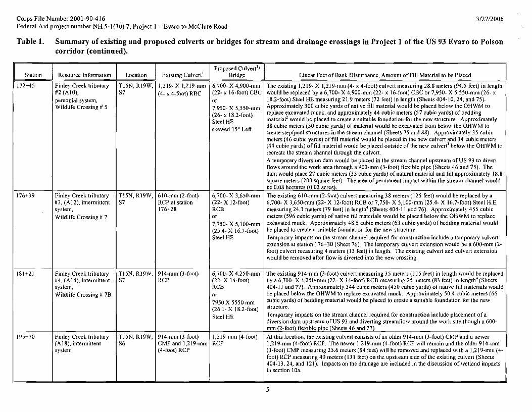
Corps File Number 2001 -90-41 6 Federal A id project number NH 5-1 (30) 7, Project 1 - Evaro to McClure Road
Table 1. Summary of existing and proposed culverts or bridges for stream and drainage crossings in Project 1 of the US 93 Evaro to Polson corridor (continued).
Station
172+45
176+39
181+21
195+70
Resource lnformation
Finley Creek tributary #2 (AIO), perennial system, Wildlife Crossing # 5
Finley Creek tributary #3, (A12), intermittent system, Wildlife Crossing # 7
Finley Creek tributary #4, (A14), intermittent system, Wildlife Crossing # 7B
Finley Creek tributaly (A1 8), internlittent system
Location
T14N, R19W, S7
T15N, R19W, S7
T15N, R19W, S7
T15N, R19W, S6
Existing ~ u l v e r t l
1,219- X 1,219-mm (4- 4-foot) RBC
610-mm (2-foot) RCP at station 176+28
914-n1n1 (3-foot) RCP
914-n1n1 (3-foot) CMP and 1,2 19-mm (4-foot) RCP
Proposed Culvert1/ Bridge
6,700- X 4,900-mm (22- x 16-foot) CBC or 7,950- 5,550-n1m (26- 18,2-foot) Steel HE skewed 15" Left
6,700- X 3,650-nlm (22- X 12-foot) RCB or 7,750- x 5 , ~ 0 0 - ~ ~ (2 5.4- x 16.7-foot) Steel HE
6,700- X 4,250-mm (22- X 14-foot) RCB or 7950 5550 mm (26.1- X 18.2-foot) Steel HE
1,219-mm (4-foot) RCP
Linear Feet of Bank Disturbance, Amount of Fill h4aterial to be Placed
The existing 1,219- X 1,219-mm (4- x 4-foot) culvert measuring 28.8 meters (94.5 feet) in length would be replaced by a 6,700- X 4,900-mm (22- x 16-foot) CBC or 7,950- X 5,550-mn~ (26- x 18.2-foot) Steel HE measuring 21.9 meters (72 feet) in length (Sheets 404-10,24, and 75). Approximately 300 cubic yards of native fill material \vould be placed below the OHWM to replace excavated muck, and approximately 44 cubic meters (57 cubic yards) of bedding material2 would be placed to create a suitable foundation for the new structure. Approxinlately 38 cubic meters (50 cubic yards) of material would be excavated from below the OHWM to create steplpool structures in the stream channel (Sheets 75 and 88). Approximately 35 cubic meters (46 cubic yards) of fill material would be placed in the new culvert and 34 cubic meters (44 cubic yards) of fill material would be placed outside of the ne\rl culvert3 below the OHWM to recreate the stream channel through the culve~t. A temporary diversion dam would be placed in the stream channel upstream of U S 93 to divert flows around the work area through a 900-n1n1 (3-foot) flexible pipe (Sheets 46 and 75). The dam would place 27 cubic nleters (35 cubic yards) of natural material and fill approximately 18.8 square meters (200 square feet). The area of permanent impact within the stream channel would be 0.08 hectares (0.02 acres). The existing 610-mm (2-foot) culvert measuring 38 meters (125 feet) would be replaced by a 6,700- X 3,650-mm (22- X 12-foot) RCB or 7,750- X 5,100-nlm (25.4- X 16.7-foot) Steel H.E. measuring 24.3 meters (79 feet) in length4 (Sheets 404-1 1 and 76). Approximately 455 cubic meters (596 cubic yards) of native fill materials would be placed below the OHWM to replace excavated muck. Approximately 48.5 cubic meters (63 cubic yards) of bedding material would be placed to create a suitable foundation for the new structure. Temporary impacts on the stream channel required for construction include a temporary culvelt extension at station 176+30 (Sheet 76). The temporary culvelt extension would be a 600-mm (2- foot) culvert measuring 4 meters (1 3 feet) in length. The existing culvert and culvert extension ~vould be removed after flow is diverted into the new crossing.
The existing 914-mm (3-foot) culvert measuring 35 meters (1 15 feet) in length ~vould be replaced by a 6,700- X 4,250-mm (22- X 14-foot) RCB measuring 25 meters (83 feet) in length4 (Sheets 404-1 1 and 77). Approximately 344 cubic meters (450 cubic yards) of native fill materials would be placed below the OHWM to replace excavated muck. Approximately 50.4 cubic meters (66 cubic yards) of bedding material would be placed to create a suitable foundation for the new
Temporary impacts on the stream channel required for construction include placement of a diversion dam upstream of US 93 and diverting streamflow around the work site though a 600- mnl (2-foot) flexible pipe (Sheets 46 and 77).
At this location, the existing culvert consists of an older 914-mm (3-foot) CMP and a newer 1,2 19-mm (4-foot) RCP. The newer 1,2 19-mm (4-foot) RCP will remain and the older 9 14-mm (3-foot) CMP measuring 25.6 meters (84 feet) will be removed and replaced with a 1,219-mm (4- foot) RCP measuring 40 meters (13 1 feet) on the upstream side of the existing culvert (Sheets 404-13,24, and 121). lmpacts on the drainage are included in the discussion of wetland impacts in section 10a.

Corps File Number 2 0 0 1-90-41 6 Federal Aid project number N H 5-1 (30) 7, Project 1 - Evaro to McClure Road
Table 1. Summary of existing and proposed culverts or bridges for stream and drainage crossings in Project 1 of the US 93 Evaro to Polson corridor (continued).
Station
198+40
199+74
Downstream of 198+40, approx. 100 m left (west) of main line roadway Sta. 198+80
204+09
Resource Information
Schley Creek (A19), perennial system, Wildlife Crossing # 8
Drainage associated with Schley Creek (A3 1 ) Schley Creek, perennial system
East Fork Finley Creek (A20), perennial system, Wildlife Crossing # 9
Location
T15N, R19W, S6
T16N, R19W, S6
T16N, R19W, S3 1
Existing culvert'
1,524-mm (5- foot) RCP
610-mm (2-foot) RCP
2,438- X 1,829-mm (8- X 6-foot) RCB at station 204+12
Proposed Culvert1/ Bridge
6,700- X 4,250-mm (22- X 14- foot) RBC or 7,750- 5,100-mm (25.4- foot) Steel HE skewed 15" right
600-mnl (2-foot) RCP, CSP, or CAP
6,700- X 4,250-mm (22- X 14-foot) RCB or 7,750- 5,100-mm (25,4- 16,7- foot) Steel HE
Linear Feet of Bank Disturbance, Amount of Fill Material to be Placed
The existing 1,524-nlm (5- foot) culvert measuring 3 1.8 meters (104 feet) in length would be replaced by a 6,700- X 4,250-mm (22- X 14- foot) RBC or 7,750- X 5,100-nlm (25.4- X 16.7- foot) Steel HE measuring 30 meters (98 feet) in length4 (Sheets 404-14, 24 and 76). Approximately 230 cubic meters (300 cubic yards) of native fill materials would be placed below the OHWM to re lace excavated muck and approximately 59.3 cubic meters (78 cubic yards) of P bedding material would be placed to create a suitable foundation for the new structure. Approximately 5.1 cubic meters (6.7 cubic yards) of concrete would be placed for cutoff walls. Approximately 42 cubic meters (55 cubic yards) of material would be excavated from below the OHWM to create steplpool structures in the stream channel (Sheet 78 and 88). Approxin~ately 52.5 cubic meters (69 cubic yards) of fill material would be placed in the culvert and 90 cubic meters (1 18 cubic yards) of fill material4 would be placed outside the culvert to create instream habitat. A temporary diversion dam would be placed in the stream channel upstream of US 93 (Sheets 78 and 43) to divert flows around the work area through a 900-min (3-foot) flexible pipe The dam would place 19 cubic meters (25 cubic yards) of natural material1 borrow in the channel, filling an 18.5-square-meter- (200-square-foot) area. The area of permanent impact within the stream channel for culvert placement and instream habitat features would be 0.016 hectares (0.04 acres).
The existing 610-mm (2-foot) RCP measuring 19.3 meters (63 feet) would be replaced by a 600- mm (2-foot) RCP, CSP, or CAP measuring 34.5 meters (I02 feet) (Sheets 404-14,24, and 122). Impacts at this site are described in section 10a. To prevent non-native fish from moving upstream, a fish barrier will be installed at the existing irrigation diversion structure in Schley Creek downstream o f US 93 (Sheets 43 and 44). The existing drop structure would be removed and a new drop structure would be installed. In addition, approximately 20 meters (65 feet) of stream channel would be regraded at a 1% slope to accommodate the additional drop. Instream work will occur outside the irrigation season (between October 1 and April 14). Flows would be diverted around the work site through a 900- mnl (3-foot) flexible pipe (probably the same on used for the culvert replacement upstream, so that only one diversion dam is required).
The existing 2,438- X 1,829-mm (8- X 6-foot) culvert measuring 25.7 meters (84 feet) would be replaced by a 6,700- X 4,250-n11n (22- X 14-foot) RCB or 7,750- X 5,100-mnl(25.4- X 16.7- foot) Steel HE measuring 24.3 meters (80 feet) (Sheets 404-l5,24, and 79). Approximately 2 10 cubic meters (275 cubic yards) of-native fill materials would be placed below the OHWM to replace excavated muck and approxin~ately 48.5 cubic meters (63 cubic yards) of bedding material1 would be placed to create a suitable foundation for the new structure. Approximately 5.1 cubic meters (6.7 cubic yards) of concrete would be placed below the OHWM for cutoff walls. Approximately 42 cubic meters (55 cubic yards) of material would be excavated for construction of steplpool st~uctures. Approximately 45 cubic meters (59 cubic yards) of fill material3 would be placed in the culvert and 117.5 cubic meters (154 cubic yards) of fill material3 would be placed outside the culvert (Sheet 45 and 79). A temporary diversion dam would be placed in the stream upstream o f U S 93 during culvert installation (Sheets 46 and 79) to divert flows around the work area through a 1500-rnm (5-foot) flexible pipe The dam would require placement of 27 cubic meters (35 cubic yards) of natural material1 borrow, filling a 28-sqaure-meter- (300-square-foot) area. The area of permanent

Corps File Number 2001 -90-41 6 Federal Aid project number NH 5-l(30) 7, Project 1 - Evaro to McClure Road
Table 1. Summary of existing and proposed culverts or bridges for stream and drainage crossings in Project 1 of the US 93 Evaro to Polson corridor (continued).
1. Culvert types: CMP- Corrugated metal pipe, CAP - Corrugated aluminum pipe, CSP- Corrugated steel pipe. RCP - Reinforced concrete pipe. RCPA - Reinforced concrete pipe arch, CSPA - Corrugated steel pipe arch, RCB - Reinforced concrete box, Steel HE - Steel horizontal ellipse.
2. Bedding material will be aggregate reasonably free of clay, silt, and other deleterious materials, arid have the following gradation: 100% passing the 4" (I00 nim) sieve; 2540% passing the No.4 - 0.2 " (4.75 nim) sieve; 12% max passing the No.200 - 0.003" (0.075 mm) sieve.
3 . Fill ~i~aterial placed in the culverts consists of natural fill material, streanibed gravels, and river rock. Fill material placed outside the culverts consists of streanibed gravels and river rock. 4 . Many of the proposed culvert lengths are shorter because the new structures are concrete box culverts and most will function as wildlife crossing structures. These culverts are measured along the box length froni
opening to opening. The ends of these culverts include wing walls or head walls that flare out and extend beyond the length of the culvert. These walls however are riot directly adjacent to the stream and therefore were not included in the linear feet of stream channel affected.
Station
2 0 7+3 6
Resource Information
S Canal
This canal diverts from and returns flows to the Jocko River.
Proposed ~ulver t ' f Bridge
1,800- X 1,500-mnl (6- X 5-foot) RCB
Location
T16N, R19W, S3 1
Linear Feet of Bank Disturbance, Amount of Fill Material to be Placed
impact within the streall1 channel for culvert installation and instream habitat features would be 0.03 acres. The existing 1,829- X 1,524-nim (6- X 5-foot) culvert measuring 19.3 meters (63 feet) would be replaced with a 1,800- X 1,500-mm (6- X 5-foot) RCB measuring 28.5 meters (93.5 feet in length (Sheets 404-15,24,47 and 123). Approximately 32 cubic meters (42 cubic yards) of bedding material would be placed below the OHWM to create a suitable foundation for the new structure. Approximately 2.2 cubic meters (2.9 cubic yards) of concrete would be placed below the OHWM for cutoff walls.
Existing Culvert1
1,829- X 1,524-mm (6- X 5-foot) RCB

Corps File Number 2001 -90-4 16 3/27/2006 Federal Aid project number NH 5-l(30) 7, Project I - Evaro to McClure Road
Table 2. Characteristics of and impact acreage for wetlands in Segment 1 of the US 93 Evaro to Polson corridor.
\j7etland ID and Associated Waterbody
AO, O'Keefe Creek
Evaro Wetland
A3, Frog Creek
A4
A 5
AS, Finley Creek
A9, Finley Creek Tributary
A10
A12
A 13
A 14
A16
Station LocationISide of Roadway 1
11 I+60 to 113+80 /LS
Along Frontage Road that accesses US 93 at station 1 19+80
13 1+60 to 134+30 /BS
I43+00 to 145+20 /LS
I48+00 to 148+60 /BS
162+40 to 163+20 /BS
- -
168+20 to 169+20'/BS
Drainage at 172+50 /BS
Seep wetland at 171+10 to 172+30
3 75+30 to 176+40 /LS
177+00 to 178+00 L S
181+20to181+80/BS
187+40 to 189+00 /RS
Temporary Impact Type
Temporary detour route
Temporary detour route
Temporary detour route
Riprap apron
Temporary detour route
Township, Range, Section
T 15N, R 20W, S 2 6
T 15N, R 20W, S 23
T 15N, R 20W, S 24
T I5N. R 20\V, S 13
T 15N, R 20W, S 13
T 15N, R 20W, S 12
-
T 15N, R 19W, S 7
T l5N, R 19W, S 7
T 15N, R 19W, S 7
T I 5N, R 19W, S 7
T15N,R 19W, S 7
T 15N, R 19W, S 6
Cowardin Class
PSS and PEM
PEM
PSS (45%) PEM (5%)
PEM
PSS (20%) PEM (80%)
PSS (60%) PEM (20%)
-
PSS (90%)
Drainage is PSS (30%)
seep is PFO (60%) PSS (40%)
PFO (20%) PSS (80%)
PSS
PSS
PEM
Dominant Vegetation
Shrub species
Sedges, grasses, carnas, willow-herb, and buttercup
Sedges, rushes, cattail, red- osier dogwood, thinleaf alder
Cattail
Primarily emergent species with some shrub species
Bebb willow, drummonds willow, alder, beaked sedge, inflated sedge, reed canarygrass - -
Alder, red-osier dogwood, sedges, large-leaved avens
Black cottonwood (drainage), Conifers with shrub species in the understory of the seep
Engelmann spruce, black cottonwood
Engelmann spruce, black cottonwood
Engelmann spruce, black cotton\wood
Cattail
MDT Rating
11
111
I1
IV
111
11
-
I1
I11 (drain-age)
11 (seep)
I1
111
I11
IV
Impact Type
roadway fill, culvert replacement
Fill from new frontage road
roadway fill, wildlife crossing structure # 1 installation, culvert replacement
roadway f i l l
roadway fill, culvert replacement, and wildlife crossing structure #2 installation
roadway fill, culvert installation, and wildlife crossing structure installation, bridge replacement
roadway fill removal and wildlife crossing structure installation
roadway fill, culvert replacement, wildlife crossing structure #5 installation
roadway fill, culvert replacement, and \wildlife crossing structure #7 installation
roadway f i l l
roadway fill, culvert replacement, and wildlife crossing structure #7B installation
roadway fill
MDT Functional
Points
6.9
5.4
7.7
1.8
4.1
9.2
-
7.6
5.7
5.7
4
3.5
1.8
Permanent Impact
Acreage
0.26
1.41
0.30
0.4 1
0.14
0.81
0.74
0.19
0.13
0.4 1
0.19
0.17

Corps File Number 2 0 0 1-90-4 16 Federal Aid project number N H 5-l(30) 7 , Project 1 - Evaro to McClure Road
Table 2. Characteristics of and impact acreage for wetlands in Project 1 of the US 93 Evaro to Polson corridor (continued).
1 Facing north, RS = right side, LS = left side, BS = both sides.
\Vetland ID and Associated Waterbody
AIS
A 19, Schley Creek
A20, East Fork Finley Creek
A2 1
A24
A27, Frog Creek Meadow
A2 8
A29
A30
A3 1
Station Location/Side of Roadway 1
196+00 to 196+40 /BS
198+00 to 198+80 /RS
203+70 to 204+60 /BS
207+00 to 208+00 /LS
205+60 to 207+60 R S
137+60to141+20/RS
156+00 to 156+50 R S
175+00 to 176+50 R S
183+60 to 184+40 R S
199+60 /RS
Township, Range, Section
T 15N, R 19W, S 6
T 1 5N, R 19W, S 6
T 16N, R I9W, S 3 1
T 16N, R 19W, S 31
T 16N, R 19W, S 3 1
T 1 5 N , R 20W, S 12
T 15N, R 20W,S12
T 15N, R 19W, S 7
T 15N, R 19W, S 6
T 16N, R I9W, S 6
Cowardin Class
PFO (95%)
PFO (40%) PSS (60%)
PSS (5%)
PSS (55%) PEM (35%)
PSS (15%) PEM (80%)
PEM
PSS (90%) PEM(IO%)
PFO (20%) PSS (80%)
PSS (90%)
Dominant Vegetation
Black cottonwood
Alder, black cottonwood
Black cottonwood, Douglas-fir
Mixture of herbaceous, shrub, and tree dominated communities
Cattail
Herbaceous species, including a camas population
Primarily shrub species
Engelmann spruce
Primarily shrub species
MDT Functional
Points
7.3
10.2
7
5.4
4.5
3.7
5
5.7
1.8
4.7
Total acres
MDT Rating
I1
I
I1
I11
111
111
111
11
IV
111
Permanent Impact
Acreage
0.22
0.07
0.48
0.26
0.45
0.13
0.01
0.22
0.02
0.03
7.05
Impact Type
roadway fill and culvert replacement
roadway fill and wildlife crossing structure #9installation
roadway fill and wildlife crossing structure installation
roadway fill and culvert replacement
S-canal
roadway f i l l and culvert replacement
S-canal
roadway f i l l and culvert replacement
roadway fill and culvert replacement
roadway fill and culvert replacement
roadway fill
roadway fill
Temporary Impact Type
Riprap apron
Riprap apron
Riprap apron

COGS File Number 200 1-90-41 6 Federal Aid project number NH 5-l(30) 7, Project 1 - Evaro to McClure Road
c. What materials will be used, and how much (cubic yards, linear feet, etc., of each)?
Roadway fill material will consist of locally excavated and processed materials with similar physical and chemical characteristics to materials that occur in the project corridor. In addition, where suitable materials are available, fill material will include embankment materials generated on site or nearby through excavation of cut areas.
This project contains numerous areas with soft mucky soils. To install wildlife crossing structures within these sites, the soft mucky soils must be removed and native fill material will be placed to replace the sub and muck excavation. Bedding material will be placed to create a suitable foundation for the structures. The bedding material will consist of aggregate reasonably free of clay, silt, and other deleterious materials. Gradations of materials to be used are provided in footnote 2 of Table 1, Sheets 46, 87, and 88. Approximate cubic yards of fill placement for streams and drainages are summarized in Table 1. Culvert types to be used and the approximate linear feet of disturbance for culvert placement are also described in Table 1. The approximate quantities of materials (bedding materials, cut off wall concrete, and stream bed gravel, etc.) for the two options for all the wildlife crossing structures are found on sheet 24. The quantities for the reinforced concrete box option are given in Table 1.
d. What equipment will be used for the work? The following equipment will likely be used for construction of the roadway including bridge installation and culvert replacement: Dozers, Track hoe, Crane, Loader, Scrapers, Blade, and Dump Trucks. Installation of the wildlife fencing may require the use of a excavator or backhoe. Hand tools will be used in many instances to complete revegetation activities.
Dozers and Excavators will be used for the restoration of wetlands and stream channels to remove temporary structures and to implement stream channel restoration. In addition, hand tools will be used in many instances to complete revegetation activities.
e. What steps will be taken during and after construction to minimize: (use additional sheets if necessary)
1. Erosion and sedimentation?
Best Management Practices included in the stormwater pollution prevention plan (SWPPP) will be implemented to minimize erosion and sedimentation during construction. After construction, exposed soils will be revegetated to prevent erosion and sedimentation to streams and wetlands. In addition, bioswales and filter strips will be implemented throughout the project corridor to provide permanent erosion and sedimentation control by intercepting stormwater and provide some detainment and treatment.
Bioswales or grassed channels will be used where stormwater runoff is concentrated. The MDT standard roadside ditch section provides a good place for bioswales with the wide, relatively flat bottom. Non-standard ditch sections can also be used as long as the design criteria are met for flow through the channel. Flow will concentrate in the roadside ditches, and run toward a stream or wetland. The bioswales will be placed in the roadside ditches leading up to the water resource to be protected.
Vegetated filter strips will provide water quality treatment for storm water runoff that sheet flows off of the highway near sensitive areas. These are used mostly in fill sections where there is no roadside ditch to collect runoff. They are also used in areas where there is a roadside ditch, but insufficient length or area for a bioswale.
2. Stream channel alterations?
Prior to construction, areas to be preserved will be fenced. All construction activities within and adjacent to stream channels will adhere to the best management practices outlined in the MDT standard specifications, special provisions, and described in the SWPPP.
The roadway fill slopes have been steepened to avoid streams and to shorten culvert lengths. These locations include:
Frog Creek (Wetland A3), Tributary to Finley Creek (A9) (Wildlife Crossing 4), Tributary to Finley Creek (A10) (Wildlife Crossing 5), Tributary to Finley Creek (Al?) (Wildlife Crossing 7), Tributary to Finley Creek (A14) (Wildlife Crossing 7B), Schley Creek (A19), and East Fork Finley Creek (A20).
At the five following stream crossings the streambed gravels and river rock will be placed to recreate the stream channel through the culvert. Streambed gravels and river rock will also be placed outside the culvert as part of the stream restoration process:

corps File Number 200 1-90-4 16 3/27/2006 Federal Aid project number NH 5-l(30) 7, Project 1 - Evaro to McClure Road
Frog Creek (A3), Tributary to Finley Creek (A9) (Wildlife Crossing 4), Tributary to Finley Creek (A 10) (Wildlife Crossing 5), Schley Creek (A 19), and East Fork Finley Creek (A20),
Finlev Creek (A81 - Stream channel alterations will occur during construction at Finley Creek with the removal of an existing culvert (Sheet 404-9) and installation of a new bridge (Sheets B2 to B3). Alterations of the stream channel will be minimized during construction by constructing the new bridge adjacent to the existing alignment. Traffic will then be shifted onto the new bridge while the existing roadway fill and culvert are removed. This method eliminates the need for a detour route, which would have required a temporary work bridge adjacent to the existing one.
3. Effects on streamflow o r water quality caused by materials used o r removal of ground cover?
All construction activities within and adjacent to stream channels and drainages will adhere to the best management practices outlined in the MDT standard specifications. Streamflow will be maintained at all sites during construction, although flows may be diverted around the work site through a pipe. In addition, a SWPPP has been prepared for this project outlining appropriate measures to be implemented during construction to reduce soil erosion and reduce site sediment loss. Prior to construction, areas to be preserved will be fenced.
Where in-stream work is required, diversion dams will be placed and stream flows will be diverted around the work site. The flow reintroduction will be staged to minimize erosion of newly stabilized areas.
I . Effects on fish and aquatic habitat? Construction of this project will result in short-term increases in turbidity in project area streams, primarily during removal of the culverts and as flows are introduced into the new stream channels. Flow reintroduction will be staged to minimize erosion of newly stabilized areas. Increases in turbidity may displace aquatic species kom the immediate project area. Overall, the project would not cause adverse long-term effects on fish or aquatic habitat.
To minimize impacts on fish and aquatic habitat, equipment will be operated kom the banks versus the channel where feasible. Where in-stream work is required and fish may be present (Finley Creek, Schley Creek, and East Fork Finley Creek), streamflow will be piped around the work site during installation of the new culverts and removal of the existing culvert and roadway fill. The flow diversion will be staged in order to minimize sediment transport and allow fish to move out of the dewatered channel, by turning half of the flow the first day, half of the remaining flow the second day and the remainder the third day.
After construction is completed, stream channels will be recreated within the wildlife crossing structures and at the onsite mitigation sites to provide instream habitat features (Sheets 39 to 46, 72 to 79, 87, and 88).
5. Risks of flooding o r erosion problems upstream and downstream? No risks of flooding are anticipated. Implementation of the SWPPP would minimize the risk of erosion and resulting sedimentation.
Stream crossings will be designed to replicate natural channels to minimize the risk of flooding after construction. Stream channels were designed using fish passage information on velocity and minimum depth as well as high (2 -year) flow and low (95% exceedance) flow (Sheet 34). Within wildlife crossing structures, a shallow slope will be constructed between the edge of the channel and the wildlife path within the structures to accommodate discharges greater than the 2-year storm and will likely contain major floods including the 50- and 100-year events. Steplpool (weir) systems will be used at Finley Creek Tributary 2 (AlO), Schley Creek (A19), and East Fork Finley Creek (A20) to maintain low velocities and achieve steep gradients to minimize the flood risk and prevent bedload accumulations within the wildlife crossing structures (Sheets 75, 78, and 79, respectively).
10. COMPLETE 10(a) through 10(c) ONLY if you are applying for a FLOODPLAIN OR SECTION 404lSECTION 10 PERMIT
a. Will the project involve placement of fill material in a wetland? If yes, describe. How much wetland area will be filled? Include a delineation of the wetland boundary and a calculation of the impacted acreage.
Permanent Impacts
Yes, the project involves placement of fill in several wetlands. A total of 7.05 acres of wetlands will be permanently filled by the project. All wetland impacts are summarized in Table 2. Table 2 summarizes the wetlands in the project area including wetland ID, location, associated waterbody, Cowardin classification, dominant vegetation, MDT rating, MDT functional points, permanent and type of temporary impact. Wetland areas, the impact locations (indicated by a cross-hatch pattern), and the amount of impact in acres are shown on the attached plan sheets (Sheets 404-1 to 404- 15). Please note that these sheets also depict the locations and impact area associated with wetlands that are not under the jurisdiction ofthe Corps as
11

' COGS File Number 200 1-90-41 6 Federal Aid project number NH 5-l(30) 7, Project 1 - Evaro to McClure Road
confirmed by Todd Tillinger via an October 20,2003 email. These wetlands are regulated by Confederated Salish and Kootenai Tribes. These wetlands are clearly labeled on the plan sheets and are not included in Table 2. Riparian areas shown on Sheets 404-1 to 404-15 represent non-wetland areas adjacent to wetland or stream features that provide riparian functions. These areas do not meet the criteria of a jurisdictional wetland according to the 1987 manual; however, these sites are regulated by the Confederated Salish and Kootenai Tribes and are therefore shown on these plan sheets.
Minimization of Permanent Impacts
This segment of the US 93 corridor begins as a four-lane roadway in Evaro and transitions to a three-lane configuration (two lanes and an alternating passing lane). Long-term effects on aquatic habitats were minimized through roadway designs, including changes in the horizontal alignment to minimize impacts on wetlands. The bridge over Finley Creek (A8) (station 162+40) was lengthened to span the entire wetland area east of the railroad tracks. In addition, fill slopes at wetland A27, station 137+00 to 148+00, were steepened fiom 6: 1, typically required by MDT, to 4: 1. This change avoided 1.34 acres of impact at this location. Where guardrail is proposed, fill slopes were steepened to avoid streams and wetland areas (guardrail locations are shown on Sheets 404-1 to 404-1 5).
Compared to the initial estimate of impacts completed at the time of the 200 1 Reevaluation, which did not include the Evaro Wetland, 1.60 acres of impact were avoided through roadway design modifications in this segment. An attempt was made to avoid impacts at the Evaro wetland. Shifting the Frontage Road to the northwest as close to the railroad tracks as feasible to minimize the impact on this wetland was investigated. However, Montana Rail Link maintains a right-of-way along their railroad tracks. Therefore, the location of the Frontage Road on Sheet 404-2 represents the minimum distance &om the railroad tracks allowed by the Montana Rail Link, and wetland impacts could not be further avoided.
Temporary Impacts
Temporary impacts are necessary for construction of detour routes, riprap aprons, and construction vehicle access. Locations where these impacts would occur are provided in Table 2. In these areas, any temporary fill will be removed and the site will be regraded and seeded after construction is complete.
Additional temporary impacts on wetlands would result fiom the installation of wildlife fencing. Wildlife fencing would be buried to a depth of approximately 0.9 meters (3 feet) below ground and would extend approximately 6 feet above ground (Sheet 91). Fencing locations are designated on Sheets 156-195. To minimize impacts, where soils allow, a trencher could excavate the trench. In other locations an excavator or backhoe with a 0.6-meter- (2-foot) wide bucket would be used to excavate the trench. The trench would then be backfilled with the excavated soils and the area would be seeded.
ONSITE MITIGATION
This segment also includes four wetland mitigation sites for unavoidable impacts on wetlands in the US 93 Evaro to Polson corridor. These sites include the Frog Creek, Finley Creek - MRL Overcrossing, Finley Creek - Abutment Removal, and Wildlife Crossing 4 mitigation site. Impacts at the mitigation sites are included in Tables 1 and 2 and the design is described below.
Frog Creek Mitigation Site
Location
The Frog Creek mitigation site is located at the US 93 crossing of Frog Creek at approximately station 132+87 (Sheets 404-4, W-2, 39, and 72). The mitigation site is located in MDT right-of-way. Existina Condition
Currently, Frog Creek is conveyed under US 93 through a 6 10-rnrn (?-foot) reinforced concrete pipe. The riparian corridor immediately adjacent to the highway crossing consists of a narrow band of forested, shrub, and emergent species on the west side. On the east side of the highway, the stream flows within the highway right-of-way through a roadside ditch dominated with sedges. Beyond the right-of-way on the east side of the roadway, shrub species dominate. Common species found at this site are serviceberry (Syrnphoricarpus sp.), alder (Alnus incana), and hawthorne (Crataegus douglasii).
The wetland functional assessment conducted at this site rated the Frog Creek system as a Category I1 system yielding 7.7 functional points.
Miti.cation Prooosal
The wetland mitigation proposal for this site involves relocating the stream channel, replacing the culvert under US 93, restoring instream habitat features, slightly expanding the floodplain, and planting the site with native species.
A new 100-meter (3 13,-foot) stream chamel would be excavated within the upland area to the north of the existing channel and Frog Creek would be relocated out of the roadside ditch (Sheet 39). The existing 610-mm (;-foot) culvert underneath US

' Cofps File Number 200 1-90-4 16 Federal Aid project number NH 5-l(30) 7, Project 1 - Evaro to McClure Road
93 would be replaced with a 2,150- X 1,500-mm (7- X 5-foot) CBC or 3,000- X 2,150-rnm (9.8- X 7.0-foot) Steel HE approximately 48 meters (160 feet) to the north, which will also function as a wildlife crossing structure (Sheets 404-4 and 72). The new stream channel would include bank habitat log features and would be lined with stream gravels and river rock to create instream habitat (Sheet 39). The abandoned channel segment on the west would be regraded to maintain wetland characteristics and planted with site appropriate species. The abandoned channel segment (approximately 45 meters [148 feet]) on the east side would be filled and planted with species suitable for the highway right-of-way. Froa Creek Credits
The total area of creation at the Frog Creek site is 0.08 hectares (0.21 acres). Therefore, this site is ex~ected to yield 0.21 acres of Corps credits (Sheet PP- 1) using a 1 : 1 crediting ratio.
Finley Creek - MRL Overcrossing: Mitigation Site
Location
The Finley Creek - MRL Overcrossing mitigation site is located at the crossing of US 93 and Finley Creek and the Montana Rail Link at approximately station 162+80 (Sheets 404-9, W-3, and W-4). This site is owned by MDT. Existinn Condition
The Montana Rail Link parallels Finley Creek at this location and bounds the floodplain to the south. Currently, Finley Creek is conveyed under US 93 through a 1,800-mm (6-foot) corrugated steel pipe. Upstream of US 93, beaver activity has created a pool at the culvert inlet. The riparian corridor of Finley Creek near the highway crossing primarily consists of shrub species with emergent species common along the banks of the stream channel. Common species found at this site are Bebb willow (Saliw bebbiana), raspbeny (Rubus sp.), sedges (Carex sp.) and mannagrass (Glyceria sp.).
The wetland functional assessment conducted at this site rated the Finley Creek system as a Category I1 system yielding 9.2 functional points. Mitieation Proposal
The proposed roadway project would replace the existing culvert with a 340-foot multi-span bridge. The wetland mitigation proposal for this site involves restoring the stream channel and floodplain in the area currently covered with roadway fill material. After the culvert and associated fill is removed, a new channel will be excavated and adjacent areas will be regraded to maintain wetland characteristics. The channel will be lined with gravels and river rocks. In addition, upstream and downstream reaches of the stream channel will be regraded an instream features will be added. Bank habitat log features and overhanging and toe log habitat features will be added to the stream channel to create instream habitat (Sheets 40 and 4 3 , and the site will also be planted with a variety of site appropriate species (Sheets W-3 and W-4). Finlev Creek Credits
The total area of restoration at the Finley Creek - MRL Overcrossing site is approximately 0.37 hectares (0.92 acres). The MDT hc t iona l points are expected to increase from 9.2 to 9.6 for this site. In addition, the site would improve from a Category I1 wetland to a Category I wetland. Based on the following calculations, this site would yield 0.14 ha (0.34 acres) of Corps credits (Sheet PP-2 and PP-3).
Reestablishment - 0.32 acres (1 12 sq meters + 1201 sq meters) at 1.1 = 0.32 acres of credit.
Enhancement - 0.60 acres (148 sq meters + 2275 sq meters) at 25: 1 = 0.02 acres of credit.
Enhancement factor = 'pas, - ' p r e (9.6 - 9.2 ) ( Fpre ) = 9.2
= 0.04 --- 25:l
Finlev Creek - Abutment Removal Mitigation Site
Location
The Finley Creek Abutment Removal mitigation site is located on Finley Creek, approximately 200 yards downstream of the US 93 crossing at station 162+80, which is the location of the Finley Creek - MRL Overcrossing mitigation site. This site is owned by Montana Rail Link; and MDT and MRL have developed a conservation easement and maintenance provisions to preserve this site.
exist in.^ Condition
Currently, Finley Creek is conveyed through a culvert under an abandoned roadway abutment. Upstream of the culvert, the culvert inlet is partially filled, creating a large ponded area. The riparian area upstream of the culvert is primarily a shrub community dominated by willows and raspbeny. Downstream of the culvert, the riparian area is a narrow forested draw dominated by en gel ma^ spruce (Picea engelmanni) and Douglas-f~ (Pset~dotsuga memiesii).

Corps File Number 200 1-90-416 Federal Aid project number NH 5-l(30) 7, Project 1 - Evaro to McClure Road
The wetland functional assessment conducted at this site rated the onsite wetlands as Category I1 yielding 7.9 functional points.
Miti.qation Proposal
The wetland mitigation proposal for this site involves removing the existing culvert and abutment fill material and restoring the stream channel and floodplain.
In addition, the site would be regraded to recreate the stream channel and associated floodplain, creating a transition from the shrub dominated wetland upstream of the abutment to the narrow riparian forest downstream of the abutment (Sheet 41). Native vegetation would be planted along the floodplain at the abutment removal site (Sheet W-5)
The project will create 50 meters (160 feet) of stream channel where culvert and fill are removed and an additional 50 meters (160 feet) of stream channel will be enhanced. Adjacent wetlands will be regraded and planted to recreate the floodplain in this reach.
Finlev Creek Abutment Credits
The total area of restoration at the Finley Creek Abutment Removal site is 0.09 hectares (0.23 acres). The MDT functional points for the wetland restoration area are expected to increase from 7.9 to 8.8. The site is expected to retain a Category I1 rating and yield 0.07 hectares (0.17 acres) of Corns credits, based on the following calculations (Sheet PP-4).
Reestablishment - 0.16 acres (90 sq meters + 569 sq meters) at 1: 1 = 0.16 acres of credit.
Enhancement - 0.07 acres (49 sq meters + 246 sq meters) at 9: 1 = 0.0 1 acres of credit.
(8.8 - 7 .9 ) Enhancement factor =' =0.11 --- 9:l
Finlev Creek Tributary - Wildlife Crossing, 4 Mitigation Site Location
The Finley Creek tributary, wildlife crossing 4 mitigation site is located on the west side of US 93 at station 168+60 (Sheets 404-9 and 404-10). This site is owned by CSKT. Agreements on the future protection of this site will be provided as soon as they are available.
Existine Condition
The mitigation site is located in a narrow, steep draw that leads to a conifer-dominated riparian system. Currently, an access road completely fills the draw with a small culvert for water passage in the bottom of the draw. Conifers dominate the overstory of the riparian area and shrub species such as alder and red-osier dogwood (Cornus stolonfera) dominate the shrub layer. Herbaceous species, including large leaved avens (Geum macrophyllum) and sedges dominate the understory.
The wetland functional assessment conducted at this site rated the onsite wetlands as Category I1 yielding 7.6 functional points.
Mitiaation Proposal
The proposed roadway project would remove the access road, associated fill material, and culvert from the narrow riparian draw. A new stream channel would be created and restored in the draw bottom and stream gravels and bank habitat logs would be added for instream habitat features (Sheets 42 and 74). Native vegetation would be planted along the new stream channel (Sheet W-6).
Finlev Creek Tributaw Credits (Wildlife Crossinp 4)
The total area of restoration at the Finley Creek Tributary, wildlife crossing 4 mitigation site is 0.10 hectares (0.25 acres). The MDT functional points for the wetland restoration area are expected to increase to 7.9. The site is expected to retain a Category I1 rating. Based on the following calculations, this site would yield 0.04 hectares (0.11 acres) of Corps credits (Sheet PP-5).
Reestablishment - 0.1 1 acres (41 sq meters + 408 sq meters) at 1: 1 = 0.1 1 acres of credit.
Enhancement - 0.10 acres (30 sq meters + 358 sq meters) at 25: 1 = 0.004 acres of credit.

Corps File Number 200 1-90-4 16 Federal Aid project number NH 5-l(30) 7, Project 1 - Evaro to McClure Road
(7.9 - 7 .6 ) Enhancement factor = = 0.04 --- 25: 1
b. List names and addresses of landowners adjacent to and across fiom the project site. (At its discretion, the permitting agency may contact these landowners.)
See Table 3 Landowner List for non-tribal landowners adjacent to the project site and other interested parties in the project corridor. The attached list includes all non-tribal landowners adjacent to the project site and those parties within 300 feet of the beginning and ending points of the project site.
c. If you have already applied for any permits, list them and indicate whether they were issued, denied, or are pending.
The following permits will be sought.
CSKT - ALCO 87A Permit Flathead Agency Irrigation District - Special Use Permit MFWP - SPA 124 Permit EPMCSKT - 40 1 Certification MT DEQ - MPDES Permit EPA - NPDES Permit
The contractor will be responsible for obtaining other necessary permits.
d. FEMA Map Number: Not available.
e. Does this project comply with local planning or zoning regulations? Yes No

Coips File Number 200 1-90-4 16 Federal Aid project number N H 5-l(30) 7, Project 1 - Evaro to McClure Road
Application Submittal Information (Send only to those agencies checked on page one of this form.)
310 Permits. Submit three copies of the application form and plans to the conservation district. Nothing additional is required unless specifically requested by the conservation district. Application review usually takes 30 to 60 days. SPA 124 Permits (government projects only). A set of preliminary plans or sketches of the proposed project must accompany the application. (Note: For projects sponsored by the Department of Transportation, two sets of plans must be sent with this form to the Helena DFWP office.) Application review may take up to 60 days. Floodplain Permits. Prior to submitting this application, contact the local floodplain administrator. Permit requirements and fees may vary. Applicant may be required to hire a professional engineer to submit plans. Application review usually takes up to 60 days. Section 404lSection 10 Permits. Nothing additional is required unless specifically requested. Application review may take 30 to 120 days. 318 Authorizations. Do not send this form directly to DEQ if you are applying for a 310 permit of SPA 124 permit. You will be notified if you must apply. If this authorization is needed, application review usually takes 10 days. Easements on State Navigable Water Bodies. Additional fees, a land survey, and other information will be required. Contact the local DNRC land office for information. Land use license review usually takes up to 60 days. Easements may take up to 90 days.
I certify that the above statements are true and correct. I fiuther certify that I possess the authority to undertake the work described authorities. Both the landowner and the person doing the work have the duty to comply with the stipulations of all permits and laws.
Signature of Landowner Date Signature of Applicant Date (may be waived by agency for utilities and other easement holders)
Contractor/Agent Date
For 310 applicants only
When an applicant or other team member disagrees with the conservation district supervisors' decision, the applicant or other team member shall request that an arbitration panel be appointed as provided in MCA 75-7-1 13 to hear the dispute and make a decision. The request must be made in writing and must be received by the district within five working days of the receipt of the supervisors' decision. Disputes may also be solved informally. The rules of arbitration are included with this form.
By signing this form, I acknowledge that I have read and understand the Natural Streambed and Land Preservation Act rules of arbitration and agree, in any disputes arising from the supervisors' decision, to abide by the rules of arbitration.

peox aln(33pv 01 oler\g - I 13aro~d '1 (OE)I-s HN laqmnu parold p!v papa3 9 1 P-06- IOOZ JaWnN al!d sd~03
18- 1
08- 1
6~- [
SL- l SL- 1
PL-1
EL- 1
SL- I
92-1
LE- I SZ-[
PS-I El-I
ZZ-I
IZ-1
OZ- 1
8 1-1
LI- I
9 1 - I
2 1- 1
PI- I
El-l
ZI- I
! [ I - I 01- 1
6-1 8- 1
L- 1
9- 1 5- I
P-l
E-I
i;-1
1-1 - .ON
la3led
80865 80865
80865
80865 80865
80862
80865
80865
80865
80865
20865 20865
80865 80865
80865
90865
80865
80865
80865
20865 OEP16
Z086C 02965
80865
80865
80865
10865
80865
80865
.n ai(e>~ pue .D p!~ea i(ali!qs pue .v d~~al
/(pnll pue same1
ple~a~) pue .x au!fanb3ef
'>I aua%p!ltl pue lle~ a!~e~ uala~ prle u!~la~
,(a[i!qs pue 'V X~iaf
ma1 ae~ pue .v L~AJ~H
'8 a11!3"7
a3601 epuaJa pue srlna? uaqdals
em13 Pue "I Pleu03 e.1~13 pue .? pleuo3
.lalad
.a au!qdaso[
.? uo~eqs
euomex pue uaqlv
a!le~ pue KI!N~N
auke~ -3
UAIJW eJeS pue .N inquv
V S!JW
? EPu!?
'x hn? pue '3 uaqox
'3 p!"ea eJeqJea pue (re3
qoo~q3~ uuv agnf pue aui(e~
euualg pue '7 uaqox
'>I pleuoa same1 pleuox pug a!~ek~ uuv
.X uaq3la.lg
arwN ISJ!~ JaUh\O
euezznky suo~uru!g
laph\o.13
?l!se?ln? lanes
vq3sa suoruru!g
~d uos.Ialad
su!ZZ!H
a?lJe13 a?lJel3
!JJaq!? ueruna~
a.rea~
a?l3eeH
1aqe.L apeq3suadsg
ql!u~sh\oi~v
WJJo?
i(alu1a'I
(uemnil) qz~eu~ure~
euemoky 30 aleis uospuepg
aia!ne3 '.I[ 'uospne1~3
noleu11 "au~ '~ea-,v\o~3
.~UI '~alua3 k!unmuro3 oie~3
d?? 's~ua~u~sa~u~ M
PealsIeH laddalx
qezsq
%!II!M
ssau!sna /ame~ lseq .rau,\\o
PX sau!d Zu!~ads!qM 05802 N E6 /CMH OSSOZ
N £6 XMH O590Z PX Sau!d %u!~ads!qM OSLOZ PX sau!d zu!~ads!qM 0690Z
PX sau!d au!Jads!qM SOPOZ N E6 L~\H Sn 0550Z
PX sau!d S~!J~~S!YM s L EOZ
N E6 ~MH Sfl OOE6I
N E6 AH Sfl 0808 I N E6 AH Sfl 50081 N E6 L~\H Sfl 5008 I N E6 AH Sn 008LI
N E6 L\H Sn 009L I PX UlN sse~3Jea8 06 L L I
866Z xof3 'O'd N E6 J~\H Sfl OLSLI
N E6 L~\H Sn 55PLI
N E6 /CMH 5Ot.L I N E6 A~\H 55ELI
I al!nS 'PX OPueuJad ueS E E E I I N E6h\H SZZLt
S~HJO ldaa
N E61h\H S~O~ILI N E6 Sfl 560L I
PX S~OOl!l Z8 L9
aA!Ja anhlaa 6291 peox u!emnolnl .&lzz!~~ I 10 1
N E6 A~\H Sn 56691
20865 LkV elnoss!N
I0865 LW elnoss!ky
80865 LkV elnoss!~
80865 LkV elnoss!~
apo3 d!z alws &!3
LN LN
LN LN LN
LN
LN
LN
LN
LN LN
LN
LN
LN
LN
LN
Lkv LkV
LN
LN
V3
LN LN
LN
LkV LN
LN
LN LN
N E6 LMH Sn 55691 V# Ja uetleds 66L
N E6 AMH 58891
WIoN E6 Aeh\@!~ 6 I99 1
ssalppy %u!l!s~ ~aun\o
elnoss!~ elnoss!~
elnoss!~
elnoss!~
elnoss!py elnoss!~ elnoss!~
elnoss!~
elnoss!~
elnoss!~
elnoss!~ elnoss!~
elnoss!~
elnoss!~
elnoss!~
elnoss!W
elnoss!~
elnoss!~
elnoss!~
elnoss!~
opueu~ad ues
elnoss!~ eua~a~
elnoss!~
e[noss!gq elnoss!~
elnoss!~ OJ~A~
om AZJ

Corps File Nu~nber 200 1-90-4 16 Federal Aid project number NH 5-l(30) 7, Project 1 - Evaro to McClure Road
Parcel No.
1-82 1-83
1-84
1-85
Owner Mailing Address
20550 Hwy 93 N P.O. BOX 426373 (415) 621-7338
20780 US Hwy 93 N
PO Box 95
Owner Last Narnel Business
Sin~mons Brandley
Vaile
Clinkenbeard
Citv Owner First Name
Jerry A. and Shirley Kent Paul
John and Letha
Dorothv
State 1 z ip CO,
p r 94 142
59808 5982 1
MissouIa San Francisco
Missoula Arlee
Gray Wolf Drive
15 14 N. Morely Ave. 22720 US H \ y 93 N RR 1. Box 1524
1 - 122
1 - 123 1 - 126
1-127
Arlee
Napa Arlee
Arlee
Great Falls Philipsburg Missoula
Hayward
Arlee
Arlee Arlee
lvanoff
Frederick
Hendrickson Bond
4812 62nd Ave SW 170 Black Pine Rd 726 Kensineton
Barney and Evelyn Alexander Peter
Drew E. Teddv Gwen and Shirlev Ann
1-128 1 - 129 1-130
9863 Callahan Rd
23460 US Hwy 93 S
23565 US Hwy 93 N - Box 186 23580 US 93 N.
Stafford Therriault Simons
1-1 3 1
1-132
1-133
1 - 134
1 - 13 5
1-136
1-1 37
1-138
1-140
1-14]
1-142
1 - 170 1-177
P.O. Box 323
24325 US Hwy 93 N
14100 US Hwy 93 N
P.O. Box 466 24325 US H\w 93 S
Donald R. and Sandra J. Alvin and Margaret Michael H.
Arlee
Arlee
Missoula
Arlee
Arlee
Otoupalik
Kiriaze
Schulz Howes
Daniels
Lytle
Otoupalik
Morin
Lytle
Lytle Ursua
Montana Rail Link Schulz
24325 US Hwy 93 S
Ernie and Shelley
George
Gary Gordon and Lindsay M.
Alan and Rosemary Dr. John
Maurice D. and Vernabelle
Ernie and Shelley
Steven Maurice D and Vernavelle
Maurice D. and Vernavelle
Larinio L and Jill J
Obediah
Arlee Arlee
Missoula Arlee
24450 US Hwy 93 N 10 1 International Way
530 Martz Road
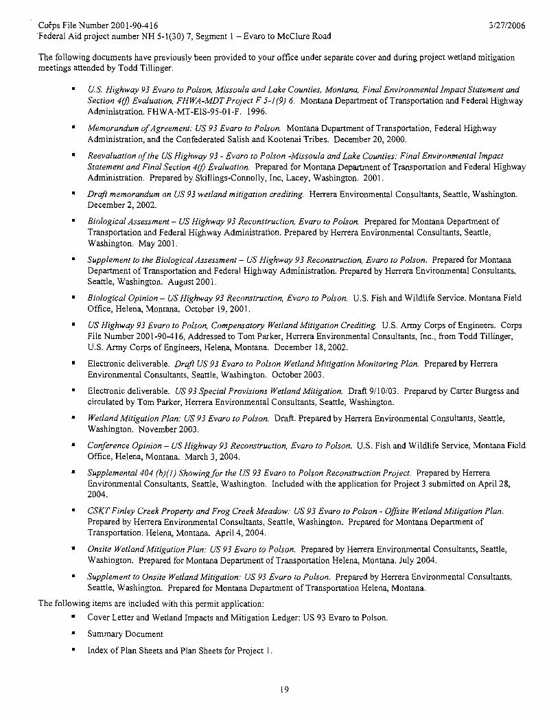
Coips File Number 200 1-90-4 16 'Federal Aid project number NH 5-l(30) 7, Segment 1 - Evaro to McClure Road
The following documents have previously been provided to your office under separate cover and during project wetland mitigation meetings attended by Todd Tillinger.
U.S. Highwqv 93 Evaro to Polson, Missoula and Lake Counties, Montana, Final Environmental Impact Statement and Section 4# Evaluation, FHWA-MDT Project F 5-I(9) 6. Montana Department of Transportation and Federal Highway Administration. FH WA-MT-EIS-95-0 I -F. 1996.
Memorandum of Agreement: US 93 Evaro to Polson. Montana Department of Transportation, Federal Highway Administration, and the Confederated Salish and Kootenai Tribes. December 20, 2000.
Reevaluation of the US Highwqv 93 - Evaro to Polson -Missoula and Lake Counties: Final Environmental Impact Statement and Final Section 1# Evaluation. Prepared for Montana Department of Transportation and Federal Highway Administration. Prepared by Skillings-Connolly, Inc, Lacey, Washington. 2001.
Draft memorandum on US 93 wetland mitigation crediting. Herrera Environmental Consultants, Seattle, Washington. December 2,2002.
Biological Assessment - US Highwqv 93 Reconstruction, Evaro to Polson. Prepared for Montana Department of Transportation and Federal Highway Administration. Prepared by Herrera Environmental Consultants, Seattle, Washington. May 200 1.
Supplement to the Biological Assessment - US Highwqv 93 Reconstruction, Evaro to Polson. Prepared for Montana Department of Transportation and Federal Highway Administration. Prepared by Herrera Environmental Consultants, Seattle, Washington. August 200 1.
Biological Opinion - US Highway 93 Reconstruction, Evaro to Polson. U.S. Fish and Wildlife Service. Montana Field Office, Helena, Montana. October 19, 2001.
US Highwqv 93 Evaro to Polson, Compensatory Wetland Mitigation Crediting. U.S. Army Corps of Engineers. Corps File Number 200 1-90-4 16, Addressed to Tom Parker, Herrera Environmental Consultants, Inc., from Todd Tillinger, U.S. Army Corps of Engineers, Helena, Montana. December 18,2002.
Electronic deliverable. Draft US 93 Evaro to Polson Wetland Mitigation Monitoring Plan. Prepared by Herrera Environmental Consultants, Seattle, Washington. October 2003.
Electronic deliverable. US 93 Special Provisions Wetland Mitigation. Draft 9/10/03. Prepared by Carter Burgess and circulated by Tom Parker, Herrera Environmental Consultants, Seattle, Washington.
Wetland Mitigation Plan: US 93 Evaro to Polson. Draft. Prepared by Herrera Environmental Consultants, Seattle, Washington. November 2003.
Conference Opinion - US Highwqv 93 Reconstruction, Evaro to Polson. U.S. Fish and Wildlife Service, Montana Field Office, Helena, Montana. March 3,2004.
Supplemental 404 (b)(l) Showing for the US 93 Evaro to Polson Reconstruction Project. Prepared by Herrera Environmental Consultants, Seattle, Washington. Included with the application for Project 3 submitted on April 28, 2004.
CSKT Finley Creek Proper& and Frog Creek Meadow: US 93 Evaro to Polson - Offsite Wetland Mitigation Plan. Prepared by Herrera Environmental Consultants, Seattle, Washington. Prepared for Montana Department of Transportation. Helena, Montana. April 4, 2004.
Onsite Wetland'Mitigation Plan: US 93 Evaro to Polson. Prepared by Herrera Environmental Consultants, Seattle, Washington. Prepared for Montana Department of Transportation Helena, Montana. July 2004.
Supplement to Onsite Wetland Mitigation: US 93 Evaro to Polson. Prepared by Herrera Environmental Consultants, Seattle, Washington. Prepared for Montana Department of Transportation Helena, Montana.
The following items are included with this permit application:
Cover Letter and Wetland Impacts and Mitigation Ledger: US 93 Evaro to Polson.
Summary Document
Index of Plan Sheets and Plan Sheets for Project 1