urs australia “pilot survey of stygofauna - red hill project”eisdocs.dsdip.qld.gov.au/red hill...
TRANSCRIPT
URS AUSTRALIA
“PILOT SURVEY OF STYGOFAUNA -
RED HILL PROJECT”
February 2012

CQ212625-2011-001 URS Australia Final Pilot Survey of Stygofauna at BMA Goonyella– Red Hill Project
i
The ALS Water Sciences Group is part of the Environmental Division of ALS, one of the largest and most
geographically diverse environmental testing businesses in the world.
CERTIFICATE OF APPROVAL FOR ISSUE OF DOCUMENTS
Client: URS Australia
Project Title: Stygofauna Pilot Survey
Report Title: Pilot Survey of Stygofauna – Red Hill Project
Document No: CQ212625-2011-001
Document Status: Final Version 2
Date of Issue: February 2012
Comments:
Position Name Signature Date
Prepared by: Manager ALS Water
Sciences QLD Garry Bennison 08/09/2011
Internal Review by: Principal Scientist Jamie Corfield 09/09/2011
Peer Review by: Senior Ecologist URS Australia
Angus McLeod 21/09/2011
Approved by: Manager ALS Water
Sciences QLD Garry Bennison 28/09/2011
For further information on this report, contact:
Name: Garry Bennison
Title: Manager - ALS Water Sciences QLD
Address: PO Box 3216 Yeronga QLD 4104
Phone: 07 3859 7802
Mobile: 0407 243 139
E-mail: [email protected]
Document Revision Control
Version Description of Revision Person Making Issue Date Approval
1 Working Draft 1 Garry Bennison 08/09/2011 GLB
2 Working Draft 2 Garry Bennison 28 /09/2011 GLB
3 FINAL Garry Bennison 10/11/2011 GLB
FINAL Version 2 Garry Bennison 16/02/2012 GLB
© ALS Water Resources Group
This document has been prepared for the Client named above and is to be used only for the purposes for which
it was commissioned. The document is subject to and issued in connection with the provisions of the
agreement between ALS Water Resources Group and the Client. No warranty is given as to its suitability for
any other purpose.
Ecowise Australia Pty Ltd trading as ALS Water Resources Group.
ABN 94 105 060 320
The photo on the front cover was taken by ALS from project work conducted in central QLD and is © ALS Water
Resources Group.

CQ212625-2011-001 URS Australia Final Pilot Survey of Stygofauna at BMA Goonyella– Red Hill Project
ii
TABLE OF CONTENTS
1 Introduction 1
1.1 Background to Project ........................................................................................................ 1
1.1.1 Overview of the Proposed Expansion Project ........................................................................................ 1
1.2 Stygofauna .......................................................................................................................... 2
1.3 Stygofauna Ecological Requirements ................................................................................. 3
1.4 Processes That Threaten Stygofauna ................................................................................ 4
1.5 Other Studies ...................................................................................................................... 5
1.6 Requirements For Sampling ............................................................................................... 6
2 Methodology 8
2.1 Sampling Protocol ............................................................................................................... 8
2.2 Bore Characteristics and Sampling Sites ............................................................................ 8
2.3 Geology ............................................................................................................................ 10
2.3.1 Moranbah Coal Measures .................................................................................................................... 10
2.3.2 Tertiary and Quaternary Formations .................................................................................................... 11
2.4 Geomorphology ................................................................................................................ 11
2.5 Aquifer Occurrence ........................................................................................................... 11
2.5.1 Quaternary Alluvial Aquifers ................................................................................................................ 12
2.5.2 Tertiary Sediment Aquifers .................................................................................................................. 12
2.5.3 Tertiary Basalt Aquifers ........................................................................................................................ 13
2.5.4 Permian Strata Aquifers ....................................................................................................................... 13
2.6 Laboratory Processing ...................................................................................................... 14
3 Results 15
3.1 Location of Sampling Sites ............................................................................................... 15
3.2 Bore Water Quality ........................................................................................................... 15
3.3 Groundwater Fauna .......................................................................................................... 15
4 Discussion 17
5 Conclusions 19
6 References 20
CQ212625-2011-001 URS Australia Final Pilot Survey of Stygofauna at BMA Goonyella– Red Hill Project
1
1 Introduction
Australian Laboratory Services (ALS) was contracted by URS Australia Pty Ltd (URS) in June 2011
to analyse five stygofauna samples collected by URS from the Red Hill Project (the project) in
central Queensland and to identify any stygofauna found to Order/Family level. URS required ALS
to prepare a report on the findings and to specifically address the following:
The presence and nature of any stygofauna occurring in groundwater likely to be affected by
the project;
The potential impacts on stygofauna of any changes in the quality and quantity of groundwater;
Any mitigation measures that may be applied.
1.1 Background to Project
BM Alliance Coal Operations Pty Ltd (BMA) operates the existing Goonyella Riverside and
Broadmeadow (GRB) mine complex. Environmental approval for the GRB mine complex is
authorised under environmental authority MIN200491507. The mine is currently producing at a rate
of approximately 14.5 million tonnes per annum (mtpa) based on a life of mine (LOM) of 57 years.
The Goonyella Riverside Mine (GRM) is an open-cut operation. The Broadmeadow Underground
Mine (BRM) is a punch longwall underground mine which has been developed off an existing
highwall of the open-cut operation.
In addition to the mining operation, the GRB mine complex includes two coal handling and
preparation plants (CHPP) which are located at the Goonyella mine industrial area (MIA) and the
Riverside MIA. The CHPP remove the non-coal materials and reduce the coal to the specified size
range. Rejects are placed into designated reject dumps. Tailings are pumped to licensed tailings
structures and the water is reclaimed for re-use in the CHPP and for dust suppression.
There is also a third MIA at the BRM.
Following processing, product coal is transported by rail to the BMA-owned Hay Point Coal
Terminal south of Mackay from where it is shipped to markets around the world.
1.1.1 Overview of the Proposed Expansion Project
BMA proposes to expand its current coal mining operations with a new greenfield underground
mine called the Red Hill Mine (RHM). The proposed development, along with increased operational
efficiencies at the GRB mine complex, will increase local product coal production rate up to

CQ212625-2011-001 URS Australia Final Pilot Survey of Stygofauna at BMA Goonyella– Red Hill Project
2
approximately 32 mtpa over an estimated 25 year LOM. The project will produce a hard coking
coal product for the export market.
The key elements of the project include:
A new underground mine within mining lease application (MLA) 70421, to the east of the GRB
mine complex, to target the Goonyella Middle Seam (GMS). The mine layout consists of a
main drive extending approximately west to east with longwall panels ranging to the north and
south.
Extension of the existing BRM into MLA70421 involving extension of panels 14, 15 and 16.
A network of bores and associated surface infrastructure over the underground mine footprint
for incidental mine gas pre-drainage and management and goaf methane drainage.
A ventilation system for ventilation of underground workings.
A new MIA for the new RHM.
A new CHPP adjacent to the Riverside MIA. The Red Hill CHPP will consist of three 1,200
tonne per hour modules.
A conveyor system linking the RHM to the CHPP.
Associated coal handling infrastructure and stockpiles.
A new conveyor linking coal stockpiles to a new rail load out facility.
Upgrades to the existing GRB site water management system to allow integration of the RHM
water management. A key component of this upgraded system will be a new water storage
dam, the RS1NX dam, located west of the existing GRB mine complex.
A new accommodation village for the construction and operational workforces with capacity up
to 3,000 workers.
A bridge across the Isaac River for all-weather access. This will be located above the main
drive, and will also provide a crossing point for other mine related infrastructure including water
pipelines and power supply.
1.2 Stygofauna
Stygofauna are aquatic animals that live in groundwater. Communities are often dominated by
crustacean invertebrates, but also contain oligochaetes, insects, other invertebrate groups, and
occasionally fish. Species occur in limestone, calcrete, and fractured rock aquifers, but seem most
CQ212625-2011-001 URS Australia Final Pilot Survey of Stygofauna at BMA Goonyella– Red Hill Project
3
abundant in alluvial aquifers (Hancock and Boulton 2008) where they are likely to contribute to
water quality through processes such as biochemical filtration (Hancock et al 2005). Scientifically,
stygofauna are extremely valuable as they have linkages to species with no or very few surface-
dwelling representatives. Examples include Bathynellacea, Thermosbanacea, and Remipeda
(Humphreys 2008). Many stygofauna evolved from surface-dwelling ancestors, so are critical to
improving our understanding of evolution and can be used to help understand the aridification of
Australia (Humphreys 2008).
1.3 Stygofauna Ecological Requirements
Stygofauna are groundwater invertebrates intricately linked to the aquifer environment and are
adapted to the relative stability of their surroundings. Compared to surface environments,
groundwater fluctuates less in level and in physico-chemical variables such as electrical
conductivity, temperature, and pH (Hancock et al. 2005). Groundwater is also generally lower in
dissolved oxygen and has less readily available organic matter than surface water environments
(Humphreys 2002). As there is no direct photosynthesis in aquifers, stygofauna rely on
connections to the land surface to provide them with food. These connections may be hydrological,
with infiltrating water bringing dissolved or particulate organic matter to form the basis of
subterranean food webs, or it may be more direct, with tree roots that extend below the water table
providing leachates or organic carbon or fine rootlets for food (Hancock et al 2005). Generally,
stygofauna biodiversity is highest near the water table and declines with depth (Datry et al 2005).
Stygofauna biodiversity is also higher in areas of recharge where the water table is close (< 10 m)
to the land surface (Humphreys 2000; Hancock and Boulton 2008). This is because the water table
is likely to have the highest concentration of oxygen and organic matter. Stygofauna still occur at
considerable depth below the water table, but are fewer in number, have lower diversity, and may
be different species (Datry et al 2005). In some karstic aquifers, where there is relatively high
vertical exchange, or flow does not come into contact with large microbial surface areas (such as
occurs in sedimentary aquifers), stygofaunal communities can occur at depths exceeding 100 m
(Humphreys 2000).
In Australia, stygofauna are known from alluvial, limestone, fractured rock, and calcrete aquifers
(Hancock et al 2005; Humphreys 2008). As yet, no species are known from coal aquifers apart
from a copepod from central Queensland that occurred in a shallow seam adjacent to an alluvial
aquifer (ALS unpublished). As stygofauna require a space to live, the porosity of the sediments,
degree of fracturing, or extent of cavity development must be sufficient, as must the connectivity
between the living spaces.
There are three critical factors that threaten stygofauna communities in aquifers impacted by
human activity. Many species need stable conditions, and groundwater communities require links
to the surface environment to provide organic matter and oxygen. It is likely that stygofauna are
able to tolerate natural fluctuations in water level, electrical conductivity (EC), and temperature, and

CQ212625-2011-001 URS Australia Final Pilot Survey of Stygofauna at BMA Goonyella– Red Hill Project
4
this has been demonstrated experimentally (Tomlinson unpublished, Hancock unpublished) for
stygofaunal amphipods, copepods, and syncarids. However, drawdown that is too rapid, or creates
too much separation between the land surface and the water table, could lead to loss of
biodiversity. Likewise, an increase in EC could also reduce biodiversity.
The third critical factor that makes stygofauna vulnerable to human activity is their high degree of
endemism (Humphreys 2008). This comes about because, unlike many surface-dwelling aquatic
invertebrates, stygofauna do not have aerially dispersing life stages. To migrate between areas,
stygofauna must be able to swim or crawl, and any barriers to this, such as an area of lower
porosity, sections of poor water quality, or other disruptions, prevent natural species migration.
This also means that stygofauna are poorly equipped to re-colonise an area once it has been
disturbed.
Many species of stygofauna are restricted to small geographical areas. This is particularly the case
in non-alluvial aquifers such as some of the calcrete aquifers in Western Australia, where one or
more species are known only from a single aquifer, or part of an aquifer (Humphreys 2002). This
means that any process that threatens the aquifer, potentially threatens an entire species. There is
also a high degree of endemism in alluvial aquifers, even between adjacent systems (Hancock and
Boulton 2008). However, providing there is sufficient hydrological connectivity within the aquifer,
and physico-chemical conditions are suitable, the distribution of species will not be restricted to
small parts of an aquifer.
1.4 Processes That Threaten Stygofauna
Stygofauna are potentially threatened by activities that change the quality or quantity of
groundwater, disrupt connectivity between the surface and aquifer, or remove living space. This
has become a particular issue for mining proponents over the last decade or so, principally because
of the perceived biodiversity value of stygofauna and the fact that little is known of their
environmental water requirements.
Mining operations incorporate a range of water affecting activities in their operations, including
some or all of the following (SKM 2010):
Below water table mining;
Water supply development (e.g. groundwater, dewatering, surface water);
Dust suppression;
Tailings disposal;
Backfilling and rehabilitation works;

CQ212625-2011-001 URS Australia Final Pilot Survey of Stygofauna at BMA Goonyella– Red Hill Project
5
Water diversions and surface sealing;
Hazardous and dangerous goods storage; and
Water storages including waste water ponds.
In recognition of the above mining activities, direct effects on groundwater dependent ecosystems
may be as follows:
Quantity (groundwater levels, pressures and fluxes);
Quality (concentrations of salts and other important water quality constituents);
Groundwater interactions (interactions between groundwater systems and between
groundwater and surface systems); and
Physical disruption of aquifers (excavation of mining pits and underground workings).
The existence and extent of these water affecting activities, and their potential impact on local to
regional scale groundwater resources, will depend largely on the scale of the mining operation,
mining method, and process water requirements, as well as climatic and geological setting.
1.5 Other Studies
The National Water Commission (NWC) has reported (NWC Waterlines 2011) that extensive gaps
exist in our knowledge of the distribution, composition and biodiversity value of Australian
stygofauna. Despite this incomplete inventory it is apparent that stygofauna are present across a
variety of Australian subsurface environments and are generally characterised by high diversity and
local-scale endemicity. They are also often of high scientific interest; for example, the occurrence
of the only known southern hemisphere representatives of several phyletic relict lineages.
In Australia, at least 750 stygofauna species have been described (Humphreys 2008), but this is a
conservative estimate of total continental biodiversity as more than 66% of known species come
from just two regions of Western Australia (Humphreys 2008) and large parts of Australia remain
unsurveyed. In Queensland there are approximately 40 species of stygofauna known, but this
estimate will certainly increase as more surveys are conducted and taxonomic knowledge
improves.
Several small surveys have confirmed at least 4 stygofaunal taxa (one Copepoda, two
Bathynellacea, and one Amphipoda) live in the Bowen Basin. To date, two species are known from
near Clermont, one near Collinsville, and one near Nebo. These were collected from
alluvial/sedimentary aquifers rather than coal seam aquifers. The likely reason for this is that the
water in the alluvial aquifers has lower EC than coal seam aquifers.
CQ212625-2011-001 URS Australia Final Pilot Survey of Stygofauna at BMA Goonyella– Red Hill Project
6
Only one stygofauna taxon is known from a coal seam aquifer - a species of harpacticoid collected
from central Queensland (ALS unpublished). This specimen occurred in a shallow coal seam (50m
deep), with low electrical conductivity (< 2000 uS/cm), a moderate to high amount of fracturing, and
a good connection to a small alluvial aquifer.
One coal mining area that has a longer history of stygofauna sampling is the Hunter Valley, where
surveys of alluvial aquifers were conducted between 2000 and 2008. Surveys of the
groundwater/surface water interface along the Hunter River between Singleton and Glenbawn Dam
from 2000 and 2003 found a diverse community of stygofauna (Hancock 2004). A follow-up project
from 2004 to 2008 surveyed groundwater monitoring bores in agricultural areas and on several
mine sites of the upper Hunter Valley (Hancock and Boulton 2008). This latter work found at least
40 taxa new to science (this number is likely to increase since not all specimens have yet been
identified to species) and confirmed that stygofauna can exist in areas dominated by coal mining. It
is worth mentioning that although the Hunter Valley has one of the richest known communities of
stygofauna in Australia, no animals were collected from coal seams. All of the bores that contained
stygofauna were in alluvial aquifers of the Hunter River and its tributaries. This may reflect a
sampling bias, since most of the bores surveyed entered alluvium rather than coal seams, and the
presence of stygofauna in coal seams should not be ruled out. However, it is likely that the majority
of taxa in the Hunter Valley do live in alluvial aquifers, which is also likely to be the case for
stygofauna in the QLD Bowen Basin.
1.6 Requirements For Sampling
Under the draft environmental impact statement (EIS) Terms of Reference (ToR) for many new or
renewing projects, aquifers need to be sampled for stygofauna as follows:
Aquatic biology
... “The EIS should provide a description to Order or Family taxonomic rank of the presence
and nature of stygofauna occurring in groundwater likely to be affected by the Project.
Sampling and survey methods should follow the best practice guideline which is currently
that published by the Western Australian Environmental Protection Authority - Guidance for
the Assessment of Environmental Factors No.54 (December 2003) and No.54a (August
2007)”…
Potential impacts and mitigation measures
... “In any groundwater aquifers found to contain stygofauna, describe the potential impacts
on stygofauna of any changes in the quality and quantity of the groundwater and describe
any mitigation measures that may be applied”…
CQ212625-2011-001 URS Australia Final Pilot Survey of Stygofauna at BMA Goonyella– Red Hill Project
7
DERM requires sampling in areas where stygofauna are ‘likely’ to occur, and for the current project,
it has been assumed that sampling is required to meet the requirements for surveys undertaken for
environmental impact assessments in Western Australia (WA), as detailed in the following
documents:
WA EPA Guidance Statement No. 54, Consideration of Subterranean Fauna in Groundwater
and Caves during Environmental Impact Assessment in Western Australia (EPA 2003);
WA EPA Guidance Statement No. 54a, Sampling Methods and Survey Considerations for
Subterranean Fauna in Western Australia (EPA 2007, or its revision).
DERM do not have any established (published) protocols for sampling stygofauna in QLD and
adopt the WA guidelines by default. The WA Guidance Statements (EPA 2003, 2007) provide
information which the WA EPA considers important when assessing proposals where subterranean
fauna is a relevant environmental factor. By adopting the WA protocols for sampling stygofauna,
results should be readily acceptable by DERM.
WA Guidance Statement 54 (2003) specifies that sampling should occur in at least two seasons
and bores should encompass the full range of aquifer types present, with the more prospective
habitats assigned significant sampling effort. The guidance statement recommends that the most
efficient sampling design will include sampling 20 impact bores (i.e. those within the zone of mining
impact) in two seasons spaced at least 3 months apart. This equates to a total of 40 impact bores
across two sampling events within the mine footprint. An equal sampling effort using comparable
methods should be expended on control bores located outside the zone of influence of the mine.
As it can be difficult for mining companies to find a sufficient number of bores outside the impact
area, a focus on finding sufficient bores inside the expected zone of impact is recommended. A
small mesh size (50 micron) is required for stygofauna sampling to ensure the reliable collection of
the smaller species of stygofauna. If stygofauna species are collected from these bores that are
not known from elsewhere (e.g. previous surveys, published literature and reports), then further
efforts will be needed to find these species from areas not affected by mining.
The WA guidelines do allow for the conduct of Pilot Studies where it is considered that the
likelihood of finding stygofauna is very low (e.g. poor groundwater quality, historic sampling of the
local area has not recovered stygofauna, lack of groundwater etc.). In the event that a Pilot Study
does find stygofauna, additional survey effort is required to satisfy the full WA Guideline
requirements.

CQ212625-2011-001 URS Australia Final Pilot Survey of Stygofauna at BMA Goonyella– Red Hill Project
8
2 Methodology
2.1 Sampling Protocol
Stygofauna were sampled using a purpose built plankton net with 150 micron mesh. The plankton
net was lowered to the bottom of each bore and moved up and down over a distance of
approximately 1 m, 3 to 5 times. The plankton net was then slowly retrieved and the entire contents
of the net washed into the sampling sieve (150 micron mesh). This process was repeated up to six
times where possible. The sample collected was then transferred to a sample jar filled with ethanol
(100% AR Grade). ALS analysed 5 stygofauna samples ‘as received’ from URS at its Brisbane
Laboratory.
2.2 Bore Characteristics and Sampling Sites
Eighteen groundwater monitoring bores were selected for stygofauna sampling by URS (Table 1).
Only 5 of the 18 bores were able to be sampled due to a combination of landholder access
issues, dry bores, piezometers installed in bores and wet ground conditions.
Table 1: Five groundwater bores were sampled for stygofauna (see highlighted rows below).
Monitoring Bore ID
Easting (m)
Northing (m)
Aquifer Screen Interval (mbgl)
Casing Diameter (mm)
Installation Date
Depth to Water (mbgl)
Sampling Notes
GW1 600214.417 7581417.76 Moranbah Coal Measures
59-65 50 2009 12.06 Sampled with four retrievals due to increasing turbidity blocking net with agitation
GW2 604622.09 7590557 Tertiary Sediments
23-29 50 2009 21.84 Sampled with three retrievals due to increasing turbidity blocking net with agitation
GW3 596942.9 7600280 Back Creek Group
30-36 50 2009 Not measured
No access to bore due to wet ground conditions
GW6 596744.5 7596096 Back Creek Group
41-47 50 2009 Not measured
Sampled with six retrievals
GW7 595291.8 7592354 Quaternary Alluvium
7-10 50 2009 Not measured
No access to bore due to land access restrictions
GW9 595763.3 7588781 Back Creek Group
21-24 50 2009 Not measured
No access to bore due to land access restrictions

CQ212625-2011-001 URS Australia Final Pilot Survey of Stygofauna at BMA Goonyella– Red Hill Project
9
GW10 592738.6 7590604 Back Creek Group
21-24 50 2009 Not measured
No access to bore due to land access restrictions
39211 602622.84 7583440.4 Moranbah Coal Measures
~54-60 50 1995 14.45 Sampled with six retrievals
39512 601932.77 7582378.8 Moranbah Coal Measures
~54-60 50 1995 Not measured
Bore Dry
39514 601845.23 7583554.8 Moranbah Coal Measures
~54-60 50 1995 Not measured
Blockage within bore @ 3mbgl prevented sampling
40448S 603253.28 7589353.7 Moranbah Coal Measures
81-87 50 1998 Not measured
Vibrating wire piezometer installed in bore not able to be removed blocking sampling access
40942 605397.95 7589587 Moranbah Coal Measures
282-291 50 1998 Not measured
Vibrating wire piezometer installed in bore not able to be removed blocking sampling access
40952 603722.1 7589367.1 Moranbah Coal Measures
237-246 50 1998 Not measured
Vibrating wire piezometer installed in bore not able to be removed blocking sampling access
43840 605109.13 7587460.2 Quaternary Alluvium
4.05-14.35
50 2006 Not measured
Bore Dry
43841 605082.28 7587287.1 Quaternary Alluvium
9.05-15.05
50 2006 13.31 Sampled with six retrievals
45318 599755.33 7584383.2 Moranbah Coal Measures
55-61 50 2003 Not measured
No access to bore due to wet ground conditions
45319 599750.49 7584387.4 Tertiary Basalt
36.7-38 50 2003 Not measured
No access to bore due to wet ground conditions
45320 599919.03 7583738 Moranbah Coal Measures
46.5-55.5
50 2003 Not measured
No access to bore due to wet ground conditions
CQ212625-2011-001 URS Australia Final Pilot Survey of Stygofauna at BMA Goonyella– Red Hill Project
10
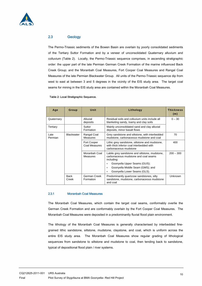
2.3 Geology
The Permo-Triassic sediments of the Bowen Basin are overlain by poorly consolidated sediments
of the Tertiary Suttor Formation and by a veneer of unconsolidated Quaternary alluvium and
colluvium (Table 2). Locally, the Permo-Triassic sequence comprises, in ascending stratigraphic
order: the upper part of the late Permian German Creek Formation of the marine influenced Back
Creek Group; and the Moranbah Coal Measures, Fort Cooper Coal Measures and Rangal Coal
Measures of the late Permian Blackwater Group. All units of the Permo-Triassic sequence dip from
west to east at between 3 and 5 degrees in the vicinity of the EIS study area. The target coal
seams for mining in the EIS study area are contained within the Moranbah Coal Measures.
Table 2: Local Stratigraphic Sequence.
Age Group Unit Lithology Thickness (m)
Quaternary Alluvial deposits
Residual soils and colluvium units include all blanketing sandy, loamy and clay soils
0 – 30
Tertiary Suttor Formation
Mainly unconsolidated sand and clay alluvial deposits, minor basalt flows
Late Permian
Blackwater Rangal Coal Measures
Grey sandstone and siltstone, with interbedded mudstone, carbonaceous mudstone and coal
70
Fort Cooper Coal Measures
Lithic grey sandstone, siltstone and mudstone, with thick inferior coal interbedded with carbonaceous mudstone
400
Moranbah Coal Measures
Labile grey sandstone and siltstone, mudstone, carbonaceous mudstone and coal seams including:
Goonyella Upper Seams (GUS);
Goonyella Middle Seam (GMS); and
Goonyella Lower Seams (GLS).
200 – 300
Back Creek
German Creek Formation
Predominantly quartzose sandstones, silty sandstone, mudstone, carbonaceous mudstone and coal
Unknown
2.3.1 Moranbah Coal Measures
The Moranbah Coal Measures, which contain the target coal seams, conformably overlie the
German Creek Formation and are conformably overlain by the Fort Cooper Coal Measures. The
Moranbah Coal Measures were deposited in a predominantly fluvial flood plain environment.
The lithology of the Moranbah Coal Measures is generally characterised by interbedded fine-
grained lithic sandstone, siltstone, mudstone, claystone, and coal, which is uniform across the
entire EIS study area. The Moranbah Coal Measures show regular grading of lithological
sequences from sandstone to siltstone and mudstone to coal, then tending back to sandstone,
typical of depositional flood plain / river systems.
CQ212625-2011-001 URS Australia Final Pilot Survey of Stygofauna at BMA Goonyella– Red Hill Project
11
The Moranbah Coal Measures are characterised by several laterally persistent thick coal seams
interspersed with several thin minor seams, which split and coalesce. Coal occurs in four distinct
horizons within the EIS study area:
Goonyella Upper Seam (GUS); P seams; Goonyella Middle Seam (GMS); and Goonyella Lower Seam (GLS).
Coal of a suitable thickness and quality to be mined is confined to the GUS, GMS, and GLS, which
sub-crop within the mining area.
2.3.2 Tertiary and Quaternary Formations
The EIS study area is covered by a 0.5 to 30 m thick layer of poorly consolidated Tertiary and
Quaternary sediments unconformably overlying an irregular erosion surface of Permian strata.
These sediments consist of lenses of river channel gravels and sands separated by sandy silts,
sandy clays and clays. The Tertiary silts and clays are densely compacted and hard. Lag deposits
of sand and gravel are found directly on the Tertiary/Permian unconformity, and can also be
present related to recent Quaternary deposition from the Isaac River.
2.4 Geomorphology
Features of subsurface geomorphological significance have not been found in the EIS study area.
The Quaternary and Tertiary formations that cover the mining area are predominantly sediments
which hold no geomorphological significance. The Tertiary basalt that occurs in the west of the
mining area is generally thin and extensively weathered, therefore no surface lava tubes or similar
geomorphologically significant volcanic features are known to be present. Exploration drilling
through basalt has not encountered voids that could be interpreted as lava tubes or lava caves.
There are no limestone or similar carbonate units on site, therefore no karst or cave systems are
present.
2.5 Aquifer Occurrence
The groundwater regime in the area of the proposed project comprises Quaternary alluvial aquifers
associated with the creeks and river in the area, Tertiary sediment aquifers, Tertiary basalt aquifers
and Permian sedimentary rock aquifers.
The occurrence and continuity of the aquifers will be highly dependent on the spatial distribution of
the corresponding geological units in the area. In general, the occurrence of the Quaternary and
Tertiary aquifers is not well defined. These aquifers are summarised in more detail below.

CQ212625-2011-001 URS Australia Final Pilot Survey of Stygofauna at BMA Goonyella– Red Hill Project
12
2.5.1 Quaternary Alluvial Aquifers
Quaternary alluvial deposits in the region occur predominantly along creeks and the Isaac River.
The Quaternary alluvial deposits associated with the Isaac River consist of 2-8 m of clay and sandy
clay at the surface underlain by up to 15 m of sand and gravel with varying proportions of clay and
silt. Potential for groundwater exists within sandy and gravelly sections of alluvium, and represents
an unconfined to semi-confined aquifer. Groundwater movement within the alluvium will be
predominantly via inter-granular flow.
Recharge to the shallow alluvial aquifer is likely to come from two main sources:
seepage from creek beds and banks during strong surface water flow or flooding; and surface infiltration of rainfall and overland flow, where alluvium is exposed and no substantial
clay barriers occur in the shallow sub-surface.
Due to their shallow depth, lack of continuity and thickness, the Quaternary alluvium is not
considered a significant aquifer. However, during periods of creek flow, the alluvium may become
fully saturated and discharge to sub-cropping coal seams.
2.5.2 Tertiary Sediment Aquifers
The Tertiary sediments of the region consist of lenses of palaeochannel gravels and sands
separated by sandy silts, sandy clays and clays. The Tertiary sediments vary in thickness from 15
to 80 m. The silts and clays are densely compacted, hard and generally dry. Potential for
groundwater exists within sandy and gravelly sections of the sediment pile, and represents an
unconfined to confined aquifer depending on location. Most of the clean sand and gravel lenses
are permeable but are of limited lateral and vertical extent. Groundwater movement within the
Tertiary sediment will be predominantly via inter-granular flow.
Recharge to the Tertiary sediment aquifers is likely to come from surface infiltration of rainfall and
overland flow, where the Tertiary sediments are exposed and no substantial clay barriers occur in
the shallow sub-surface. Recharge may also occur by vertical seepage from overlying Quaternary
alluvial aquifers.
The nature of the Tertiary sediment aquifers, and hence its permeability and porosity, is likely to be
highly variable, depending on the proportion of fine material. A review of borehole logs for the EIS
study area showed that the Tertiary stratigraphy is dominated by clays and sandy clays with
isolated areas of loose sand. Historically mining issues with Tertiary sediment derived
groundwaters appear to have been limited to pit wall stability rather than ongoing problems with
groundwater inflow, indicating the limited lateral extent of the more permeable areas.

CQ212625-2011-001 URS Australia Final Pilot Survey of Stygofauna at BMA Goonyella– Red Hill Project
13
2.5.3 Tertiary Basalt Aquifers
Tertiary basalt exists as small discontinuous remnants to the south and in the west of the EIS study
area, with a larger continuous unit to the north. The basalt is predominantly highly to extremely
weathered, clayey and dry. The distribution of less-weathered, fractured and vesicular water-
bearing basalt is variable. The Tertiary basalt aquifers are classed as a secondary porosity aquifer
and are expected to represent unconfined to confined aquifers depending on location.
Groundwater is principally stored and transmitted in the fractures, joints and other discontinuities
within the rock mass.
The nature of the Tertiary basalt, and hence its permeability and porosity, is highly variable,
depending on the degree of weathering and the intensity and interconnectedness of fracturing.
Where the basalt is less weathered and more fractured or vesicular, the unit may have local zones
of moderate to high hydraulic conductivity. Hydraulic testing at Moranbah North mine (JBT 2010)
indicated the Tertiary basalt to be moderately permeable with hydraulic conductivity values ranging
from one to four metres per day and storage coefficient between 1 x 10⁻² and 1 x 10⁻⁴. Onsite,
interpreted hydraulic conductivity values of 1.21 and 0.48 metres per day were obtained from the
variable head test for the existing southern extension of the Airstrip Pit (AGE 2004) located in the
southwest of the EIS study area. The drilling program undertaken as part of this Airstrip Pit
groundwater study showed that the Tertiary basalt appears to be highly heterogeneous and
discontinuous locally. In the area of the Airstrip Pit, the basalt intersected during drilling was
generally not water-bearing; however for the few holes that did intersect measurable groundwater
flows, airlift yields were at most 1.25 litres per second (L/s).
2.5.4 Permian Strata Aquifers
Primary porosity in the Permian strata is likely to be limited, as even the sandstone beds have a
significant clay content. Excluding the larger scale discontinuities, such as faults, flow in this unit is
therefore likely to be predominantly via fracture flow.
In common with other areas in the Bowen Basin the coal seams constitute the main aquifers in the
Permian, but the jointed sandstone overburden and interburden may also be important, locally, for
storage and transmittal of water. The vertical anisotropy in the Permian strata may restrict
upward/downward leakage, both between layers within the Permian and from the overlying Tertiary
formations and alluvium.
Recharge of coal seams is generally by direct infiltration of rainfall and overland flow in subcrop
areas, and by downward leakage from overlying aquifers in the Cainozoic formations. It is
considered that due to the clayey nature of the Tertiary formations unconformably overlying the coal
seams, recharge from rainfall infiltration will be limited.

CQ212625-2011-001 URS Australia Final Pilot Survey of Stygofauna at BMA Goonyella– Red Hill Project
14
Testing indicates that with depth the cleats and joints in the coal are less open, with a
corresponding decrease in permeability. Historically mining issues with the Permian strata derived
groundwaters appear to have been limited to pit wall stability rather than ongoing problems with
groundwater inflow, indicating the generally low permeability of the Permian strata on site.
Hydraulic testing of the interburden aquifers reveals that they have highly variable hydraulic
conductivity from relatively pervious to highly impervious. This is evidence that the water bearing
zones are heterogeneous over short distances and the very low hydraulic conductivity in some
parts would isolate more conductive parts of these zones.
2.6 Laboratory Processing
Rose Bengal, which stains animal tissue pink, was added to each sample before processing to
allow stygofauna (if present) to be distinguished from sediments and other organic matter and to
speed up the sorting process. For initial sorting, samples were elutriated to remove most of the
mineral component of the sample, and poured through a 50 µm sieve. The sieve contents,
consisting of fine sediments, were spread thinly over the base of a channelled sorting tray and
carefully picked to ensure all stygofauna (if present) were detected.
Sample jars were drained of ethanol and washed gently into channelled sorting trays to create a
thin layer of sediment spread across the bottom of the tray. Samples were then sorted under a
Leica MZ9 stereomicroscope with planachromat 10x objective lenses and a zoom capability of
between 6.3x and 60x.
CQ212625-2011-001 URS Australia Final Pilot Survey of Stygofauna at BMA Goonyella– Red Hill Project
15
3 Results
3.1 Location of Sampling Sites
The groundwater regime in the area of the proposed project comprises Quaternary alluvial aquifers
associated with the creeks and river in the area, Tertiary sediment aquifers, and Permian
sedimentary rock aquifers. The five bores selected by URS for sampling covered all the major
aquifer types located within the EIS study area (Table 1).
3.2 Bore Water Quality
The following water quality data was supplied by URS for the five bores sampled for stygofauna
(Table 3). The water quality information provided indicates four of the five bores recorded a
relatively low salinity concentration compatible with the existence of stygofauna (GW2 may be
marginal). Bore GW6 recorded a high salinity concentration and it is less likely that stygofauna
would exist in this environment. The collection method for bore water samples is detailed in the
URS Red Hill Project EIS Appendix J.
Table 3: Concentrations of major ions in the five groundwater bores sampled for stygofauna
Monitoring Bore ID Salinity Major Ions (mg/L)
µS/cm Na Ca K Mg Cl SO4 HCO3 as CaCO3
GW1
Moranbah Coal Measures
1800 77 18 4 9 64 14 151
GW2
Tertiary Sediments
7030 212 62 3 33 165 38 509
43841
Quaternary Alluvium
650 46 35 3 14 59 14 152
39211
Moranbah Coal Measures
400 13 15 8 6 21 1 62
GW6
Back Creek Group
13700 2530 222 82 300 4820 670 434
3.3 Groundwater Fauna
The ALS Brisbane laboratory analysed 5 stygofauna samples collected by URS from within the EIS
study area in central Queensland (Table 4). No stygofauna were recorded from any of the samples
collected (Table 5). The samples received by ALS were notably lacking in sediment (organic and
inorganic).

CQ212625-2011-001 URS Australia Final Pilot Survey of Stygofauna at BMA Goonyella– Red Hill Project
16
Table 4 : Details of stygofauna samples collected by URS Australia.
URS Bore Code
Date Collected
Date Received by
ALS Time
Collected Matrix Collecting Agency
Sample Preservative
GW1 18/06/11 29/06/11 1615hrs Water URS
Australia
Ethanol
GW2 18/06/11 29/06/11 1240hrs Water URS
Australia
Ethanol
43841 18/06/11 29/06/11 1520hrs Water URS
Australia
Ethanol
39211 18/06/11 29/06/11 1100hrs Water URS
Australia
Ethanol
GW6 19/06/11 29/06/11 1430hrs Water URS
Australia
Ethanol
Table 5: Results from analysis of stygofauna samples.
URS Bore Code Date Sample Collected Stygofauna
GW1 18/06/11 None Found
GW2 18/06/11 None Found
43841 18/06/11 None Found
39211 18/06/11 None Found
GW6 19/06/11 None Found

CQ212625-2011-001 URS Australia Final Pilot Survey of Stygofauna at BMA Goonyella– Red Hill Project
17
4 Discussion
Five groundwater samples were collected by URS from within the EIS study area in central
Queensland and analysed for stygofauna by the ALS Water Sciences Group in Brisbane. There
were no stygofauna present in any of the 5 samples analysed.
The following relevant information was not available to ALS at the time of preparing this report:
The geographical location of the five groundwater bores sampled in relation to both the EIS
study area and the significant local and regional hydrogeological features.
Details of the proposed operation of the project, particularly as it relates to the local
hydrogeology (i.e. proposed drawdown of aquifers).
Overall compliance with the WA guidelines (2003 & 2007) including QA/QC protocols for
sample collection.
To be suitable for stygofauna, aquifers must have sufficient porosity or fractionation for adequate
living space, and have a sufficient flux of organic matter (DOC) and dissolved oxygen (Humphreys
2008). Alluvial aquifers adjacent to large permanent rivers often have suitable conditions, and can
contain diverse stygofauna communities (Danielopol and Marmonier 1992; Hancock and Boulton
2008). Parts of aquifers with short hydrological transit time, such as those with a shallow water
table or close to recharge areas, often have high stygofauna diversity (Datry et al 2005), as do
those aquifers with tree roots entering the water table (Hancock and Boulton 2008). Groundwater
bore 43841 targeted the Quaternary Alluvium and was sampled as part of this project. This bore
was shallow, was low in salinity and would be highly prospective for stygofauna. The quaternary
alluvial aquifers located within the EIS study area should have been a key focus of the sampling
program with significant effort devoted to sampling these highly prospective aquifers at various
locations within the EIS study area. The deeper Permian Strata Aquifers (particularly the Moranbah
Coal Measures) also contained groundwater with relatively low salinity. These bores also have
potential for containing stygofauna and require a substantial sampling effort in order to be able to
conclude with some certainty about the presence/absence of stygofauna.
The absence of stygofauna from any of the project samples may be due to unsuitable geological
conditions (low porosity, low hydraulic conductivity), poor water quality or an inappropriate sampling
strategy (e.g. net design) or simply by chance that stygofauna were not present or were not
captured at the time of sampling (hence the need for replicate sampling across seasons as required
by the WA guidelines). A second round of sampling is recommended for the 2012 post-wet season
in order to confirm this.
CQ212625-2011-001 URS Australia Final Pilot Survey of Stygofauna at BMA Goonyella– Red Hill Project
18
The WA guidelines do allow for the conduct of Pilot Studies where it is considered that the
likelihood of finding stygofauna is very low (e.g. poor groundwater quality, historic sampling of the
local area has not recovered stygofauna, lack of groundwater etc.). The project is geographically
located between Clermont and Nebo in central Queensland. ALS (unpublished data) has recorded
stygofauna in the Clermont region as well as the Collinsville region in addition to south of Nebo, so
the presence of stygofauna in the area is established. The project, therefore, lies within a
prospective area for stygofauna. The water quality of some of the alluvial and tertiary sediment
aquifer bores (GW1, 39211 and 43841) were also conducive to the presence of stygofauna.
However, it is considered that these locations offer relatively low opportunities for stygofauna.
Mining proposals, where stygofauna are considered to be a relevant environmental factor, need to
be closely assessed with respect to the extent of the proposed groundwater drawdown zone and
the likely impacts on groundwater quality. Both of these activities, over time, may cause
prospective stygofauna habitat (e.g. alluvial aquifers) to be degraded or lost with the potential for
significant impact on stygofauna communities.
The stygofauna sampling equipment used in this project did not conform to WA guideline No.54A
(2007) requirements as a 150 micron mesh collection net and sieve was used. Many stygofauna
are <0.15mm in diameter (particularly the microcrustacea) and even some of the larger stygofauna
(<0.5mm) are elongate in bodyform. The WA guidelines require sampling with a very fine 50
micron mesh for the reliable collection of the smaller species of stygofauna. A larger mesh size of
150 micron may have allowed stygofauna to pass through it and be lost when processing the net
sample. The use of the larger mesh net and sieve could also explain why there was very little
sediment and organic matter in all five samples collected (refer section 3.3).

CQ212625-2011-001 URS Australia Final Pilot Survey of Stygofauna at BMA Goonyella– Red Hill Project
19
5 Conclusions
An initial round of sampling from 5 groundwater bores within the EIS study area found no stygofauna, and it is considered that the EIS study area offers relatively low opportunities for stygofauna. It is however recommended that a review of the stygofauna sampling strategy be undertaken and a second round of post-wet sampling be conducted in 2012. This survey would be undertaken using by experienced samplers using WA Guideline compliant equipment which includes 50 micron mesh and a solid framed net. A minimum of 10 groundwater bores would be sampled that include a focus on shallow alluvial aquifers within the EIS study area. This strategy would conform with a pilot study approach.

CQ212625-2011-001 URS Australia Final Pilot Survey of Stygofauna at BMA Goonyella– Red Hill Project
20
6 References
Australasian Groundwater and Environmental Consultants Pty Ltd (AGE), (2004), Groundwater
Depressurisation Assessment, Airstrip South Project – Goonyella, Project No. G1201.
Danielopol D.L. & Marmonier P. (1992) Aspects of research on groundwater along the Rhône,
Rhine and Danube. Regulated Rivers: Research & Management 7, 5-16.
Datry T., Malard F. & Gibert J. (2005) Response of invertebrate assemblages to increased
groundwater recharge rates in a phreatic aquifer. Journal of the North American Benthological
Society 24, 461-477.
Hancock P.J. (2004) The effects of river stage fluctuations on the hyporheic and parafluvial ecology
of the Hunter River, New South Wales. PhD Thesis, University of New England, Armidale.
Hancock P.J., Boulton A.J. & Humphreys W.F. (2005) Aquifers and hyporheic zones: Towards an
ecological understanding of groundwater. Hydrogeology Journal 13, 98-111.
Hancock, P., Boulton, A., and Humphreys, W. (2005) Aquifers and hyporheic zones: toward an
ecological understanding of groundwater. Hydrogeology Journal 13, 98-111.
Hancock, P.J. and Boulton, A.J. (2008) Stygofauna biodiversity and endemism in four alluvial
aquifers in eastern Australia. Invertebrate Systematics 22, 117-126.
Humphreys, W.F. (2000) First in, last out: Should aquifer ecosystems be at the vangard of
remediation assessment ? Contaminated Site Remediation Conference, Melbourne, 4-8 December,
2000.
Humphreys, W.F. (2002) Groundwater ecosystems in Australia: an emerging understanding.
Keynote address. Proceedings of the International Association of Hydrogeologists Conference,
Darwin, 12-17 May, 2002.
Humphreys, W.F. (2008) Rising from Down Under: developments in subterranean biodiversity in
Australia from a groundwater perspective. Invertebrate Systematics, 22, 85-102.
JBT Consulting, (2010), Grosvenor Coal Project Environmental Impact Study Groundwater Impact
Assessment, Project JBTO1 007 003.
NWC (2011) Evolving Issues and Practices in Groundwater Dependent Ecosystem Management.
Waterlines Report Series No.46, May 2011. SKM.

CQ212625-2011-001 URS Australia Final Pilot Survey of Stygofauna at BMA Goonyella– Red Hill Project
21
SKM (2010) Framework for Assessing Potential Local and Cumulative Effects of Mining on
Groundwater Resources. Report 15: Guidelines for Conducting a Groundwater Effects Statement.
Version 3, December 2010. National Water Commission.
WA EPA (2003) Guidance for the assessment of environmental factors (in accordance with the
Environmental Protection Act 1986). Sampling of subterranean fauna in groundwater and caves.
Guidance Statement 54. Environmental Protection Authority, Western Australia.
WA EPA (2007) Guidance for the assessment of environmental factors (in accordance with the
Environmental Protection Act 1986).Sampling methods and survey considerations for Subterranean
Fauna in Western Australia. Guidance Statement 54a: Technical appendix for Guidance Statement
54. Environmental Protection Authority, Western Australia.