urban design & transportation - home, home · urban design and transportation challenges urban...
TRANSCRIPT

3eople want Uptown to be a lively place to live, work and play. This refrain washeard clearly in the Consortium’s public meetings. To create a “sense of place”for Uptown, the Consortium's Urban Design Framework unifies disparate elements
into a coherent whole, while supporting institutional and neighborhood growth. Thisincludes strategies such as; providing a clear and visible sense of arrival in Uptown bycreating gateway features or developments, forming walkable connections betweenstrengthened neighborhood retail centers, reinforcing the historic street grid andenhancing and attracting amenities.
Building on the Urban Design Framework, the transportation vision for Uptownseamlessly connects residents, employees and visitors to jobs, shopping andamenities through a multi-modal transportation network. Uptown's transportationsystems, streets and highways, public and private transit and pedestrian and bicyclefacilities should be fully integrated and designed cohesively to better linkneighborhoods, institutions and commercial centers. Currently, these systems areoften disconnected, fragmented or redundant. The framework proposes a balancedset of transportation systems connecting neighborhoods and institutions, linkingUptown to Center City and the region, and enhancing the pedestrian environment.
STR
ATEG
IC O
PPO
RTU
NIT
Y PL
AN U
PTO
WN
CIN
CIN
NAT
I
URBAN DESIGN & TRANSPORTATION
3.2
P
Fig 3.1 The Urban Design and Transportation Framework Plan

3
STR
ATEG
IC O
PPO
RTU
NIT
Y PL
AN U
PTO
WN
CIN
CIN
NAT
I
URBAN DESIGN & TRANSPORTATION
3.3
Urban Design
• Strong existing neighborhoods are the building blocks of Uptown.
• These neighborhoods are the home of major institutions and employment centers.
• There are six existing neighborhood centers, some are vibrant, while others are struggling.
• Uptown has numerous parks and public spaces, but they are not all serving the community well.
• Momentum for revitalization is strong, but Uptown's many redevelopment projects are not yet connected together to create a coherent whole.
Urban Design and Transportation Assets
Transportation
• Uptown is accessible by major Interstate and regional roadways and from the airport.
• Several of Uptown's institutions and amenities are highly visited by local, regional and national visitors. For example, more than one million people visit the Cincinnati Zoo and Botanic Garden annually.
• Uptown and its environs are the subject of several city and state transportation initiatives currentlyunderway including the Ohio Kentucky Indiana Regional Council of Governments (OKI) Study and others.
Fig 3.2 Uptown’s neighborhoods and institutions.

Urban Design and Transportation Challenges
Urban Design
• The area lacks a strong identity for Uptown as a whole - it is divided into individual neighborhood identities. While each neighborhood should continue to have its own unique identity, all neighborhoods should also feel a larger affinity in the broader community of Uptown.
• The legacy of urban renewal has created a fragmented street grid, with one-way and non-continuous streets, as well as large land assemblages and "superblocks", leading to broken connections and disorientation for visitors.
• Urban renewal also created large land assemblages and institutional "superblocks", forming barriers between Uptown's neighborhoods.
• The natural hilly topography of the area also isolates neighborhoods from one another.
• Uptown's neighborhood centers are not all equally successful as neighborhood focal points and retail activity nodes. Some residential areas have a vibrant local shopping district within walking distance while others do not.
• Public parks and open spaces not currently serving as amenities for the Uptown community, due to inadequacies in maintenance,security, design, access, available activities and other factors.
• Many existing parking garages are unsightly,and their blank and inactive walls create "dead space" alongmajor neighborhood streets.
Transportation
• The hilly topography creates difficult sightlines for pedestrians and motorists.
• Vine Street, the historic central spine, connecting Uptown to Center City, was severed and rerouted around the existing University Plaza in the 1970's. This disconnection created Short Vine Street, a small retail center, which is difficult to locate as a pedestrian or motorist, and presents continued challenges for retailers and public safety officials. In addition, this change created the Jefferson Street bypass and largemulti-lane interchanges, resulting in significant barriers to pedestrians.
• The I-75 and I-71 Interstate connections in Uptown are poorly designed and difficult to navigate for motorists.
• Some of Uptown's key streets (such as Jefferson Avenue) are designed according to highway or suburban roadway standards, and thus poorly balance traffic flow with pedestrian needs.
• There is limited parking for institutions and neighborhood amenities in some areas. Discussions among Uptown's institutions to create shared parking alternatives have occurred, but no concrete plans have yetmaterialized.
• Local and regional transportation initiatives appear to exacerbate Uptown's transportationchallenges by continuing to view Uptown as place to "drive through" instead of place to drive to and stay.
3
STR
ATEG
IC O
PPO
RTU
NIT
Y PL
AN U
PTO
WN
CIN
CIN
NAT
I
URBAN DESIGN & TRANSPORTATION
3.4

3URBAN DESIGN & TRANSPORTATION
STR
ATEG
IC O
PPO
RTU
NIT
Y PL
AN U
PTO
WN
CIN
CIN
NAT
I
3.5
Fig 3.3 Urban Design & TransportationChallenges: The intersection of MLK and VineStreet
Fig 3.4 Urban Design & TransportationChallenges: The superblock at the south end ofShort Vine.
Urban Design and Transportation Assets and Challenges: Conclusions
Looking at these assets and challenges it is clear that Uptown already possesses mostof the ingredients for success as a vibrant, diverse urban district. What is missing is theright recipe - a way to think about these assets as working together towards a commonvision for the area, creating synergies and spinoff benefits, eliminating redundancy andbuilding a coherent whole. The Urban Design Framework is designed to provide thefirst draft of such a structure.
The Framework is a synthesis of many ideas, and combines small, medium and largeproposals and short and long-term opportunities. Several strategic infrastructureprojects are proposed as important elements of the Framework; "big moves" that willhelp unlock the potential of Uptown. Principal among these is the reconnection of VineStreet - an opportunity that will have a positive ripple effect through many areas, fromtraffic, to pedestrian safety, to retail vitality, to removing barriers between campus andcommunity.
The "Strategic Opportunities" that follow are not freestanding ideas, but build to form acomplete picture. Each opportunity creates better conditions for the other ideasdiscussed in this chapter and in this report to succeed.

STR
ATEG
IC O
PPO
RTU
NIT
Y PL
AN U
PTO
WN
CIN
CIN
NAT
I
3.6
Strategic Opportunity 1:Strengthen and reinforce theexisting urban grid
Uptown can be disorienting and confusing tomove around by automobile: this is a result of thehilly topography as well as a history of urbanrenewal that caused the closing or rerouting ofnumerous streets. Of all of these changes to thestreet grid, the most damaging was the severingof Vine Street, the historic spine linking Uptownto Center City and the Ohio River.
The Strategic Framework plan recommends therestoration of some of these lost connections,including the reconnection of Vine Street, as wellas the strengthening of the existing street grid byresponding to the strong hierarchy of major andminor streets to provide orientation andwayfinding. Several major arterial streets traverseUptown; these must be easy to find, follow, andmove among if the area and its destinations areto become more accessible and unified.
Vine Street and Martin Luther King Boulevard aremajor routes crossing through the area andconnecting to the surrounding region and thehighway system. Additional major streets, suchas Clifton Avenue, Burnet Avenue, and ReadingRoad, among others, also define the area'sneighborhoods and institutions.
This street pattern, essential to movement andaccess within Uptown, should be strengthenedand made clear to motorists and pedestriansthrough a variety of techniques. This goal shouldbe consciously followed during any redesign ofstreets, intersections or interchanges, as well asin the creation of wayfinding and signagesystems, and even in the design of maps of thearea for visitors. A clear street network can makethis complicated area easier to navigate andtherefore more likely to attract and retain visitors.
3URBAN DESIGN & TRANSPORTATION
Fig 3.5 Uptown’s major arterial streets and the retail corridors located along them.

Strategic Opportunity 2:As part of institutional planning,create better access to andthrough large institutionalcampuses, superblocks andparks
Like the historic changes to the street grid, theexpansion of Uptown's large institutions over theyears has created large areas of land, or“superblocks”, with few through-connections,forming barriers between Uptown'sneighborhoods. In some cases, it is possible tomove through these areas, but the lack ofsightlines, winding pathways or limitations onpublic access make them seem inaccessible.
Burnet Woods is also a large property with poorthrough-connections, creating a barrier. In somecases, including Burnet Woods, former streets orconnections were closed for safety or otherreasons.
The Framework seeks to make these areasboth safe and accessible through acombination of strategies. While new streetsthrough institutional campuses may not beappropriate except in select cases, the goalof making superblocks and parks moreopen can be acheived through a variety ofother means.
The superblocks can become more openand accessible by creating andstrengthening pathways and connections forthe public, and by enhancing lighting,security, wayfinding and other aspects topromote their use.
In selected cases, new streets may be anappropriate way to improve connections andmake historic superblocks more accessible.Such streets should be designed to “calm”traffic flow and balance pedestrian needs, inconcert with enhanced management andsecurity policies.
3
STR
ATEG
IC O
PPO
RTU
NIT
Y PL
AN U
PTO
WN
CIN
CIN
NAT
I
URBAN DESIGN & TRANSPORTATION
3.7Fig 3.6 Connections through Uptown’s superblocks should be strengthened, and new links created.

Strategic Opportunity 3:Explore the feasibility ofreconnecting Short Vine with VineStreet
Vine Street is a major local north southcontinuous route that connects Uptown withCenter City and the Ohio River. It is one of thekey Uptown streets, but was disconnectedthrough 1960's urban redevelopment initiatives.The Team studied conceptual options forreconnecting Vine Street, to provide thecontinuity and orientation that the street onceprovided. Vine Street may not be an appropriatecarrier of long trips, but it is important to theidentity of Uptown and the area's relationship tothe rest of the city.
To reconnect Short Vine Street, severalmodifications should be made to both the south(at William H. Taft Road) and north (at MartinLuther King Boulevard) ends. These changesmay allow better service to both the Short Vine
and Taft/McMillan retail areas. Such modificationsmay also improve access and circulation to theseareas from MLK, and reestablish the historiccontinuity of Vine Street.
The study contemplates three alternatives toconsider both the vehicular impacts of VineStreet's reconnection and the correspondingeffects on pedestrian accessibility anddevelopment opportunities. The improvements ateither end of Vine Street may be interchangedamongst alternatives; however, therecommended alternative is based on theStrategic Opportunity Plan' objectives.
A. No Action Alternative
There are several concerns with the existingroadway configuration. The termination of ShortVine Street at Taft Road creates a "superblock"that acts as a visual, pedestrian and vehicularbarrier. This design is not conducive to an urbanenvironment, and requires extended search
3
STR
ATEG
IC O
PPO
RTU
NIT
Y PL
AN U
PTO
WN
CIN
CIN
NAT
I
URBAN DESIGN & TRANSPORTATION
3.8Fig 3.7 Reconnecting Vine Street - No Action Alternative (existing conditions).
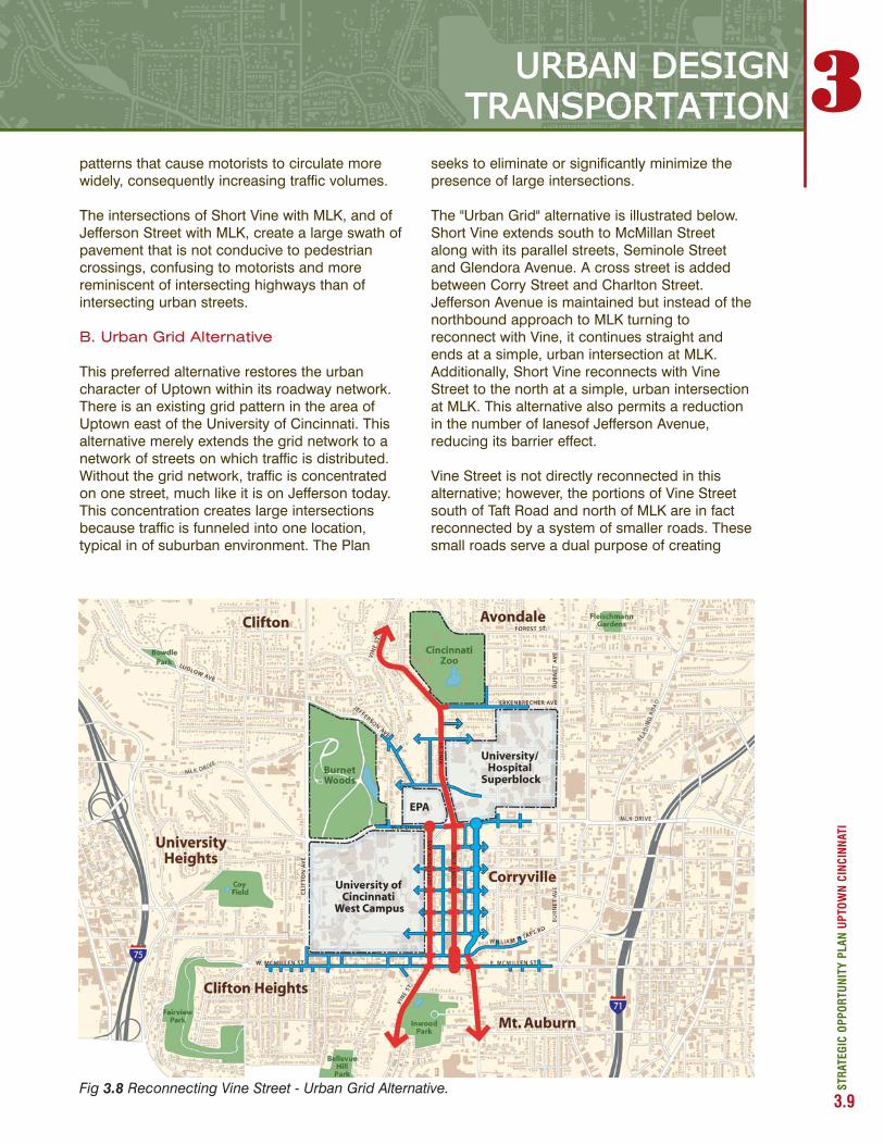
patterns that cause motorists to circulate morewidely, consequently increasing traffic volumes.
The intersections of Short Vine with MLK, and ofJefferson Street with MLK, create a large swath ofpavement that is not conducive to pedestriancrossings, confusing to motorists and morereminiscent of intersecting highways than ofintersecting urban streets.
B. Urban Grid Alternative
This preferred alternative restores the urbancharacter of Uptown within its roadway network.There is an existing grid pattern in the area ofUptown east of the University of Cincinnati. Thisalternative merely extends the grid network to anetwork of streets on which traffic is distributed.Without the grid network, traffic is concentratedon one street, much like it is on Jefferson today.This concentration creates large intersectionsbecause traffic is funneled into one location,typical in of suburban environment. The Plan
seeks to eliminate or significantly minimize thepresence of large intersections.
The "Urban Grid" alternative is illustrated below.Short Vine extends south to McMillan Streetalong with its parallel streets, Seminole Streetand Glendora Avenue. A cross street is addedbetween Corry Street and Charlton Street.Jefferson Avenue is maintained but instead of thenorthbound approach to MLK turning toreconnect with Vine, it continues straight andends at a simple, urban intersection at MLK.Additionally, Short Vine reconnects with VineStreet to the north at a simple, urban intersectionat MLK. This alternative also permits a reductionin the number of lanesof Jefferson Avenue,reducing its barrier effect.
Vine Street is not directly reconnected in thisalternative; however, the portions of Vine Streetsouth of Taft Road and north of MLK are in factreconnected by a system of smaller roads. Thesesmall roads serve a dual purpose of creating
3
STR
ATEG
IC O
PPO
RTU
NIT
Y PL
AN U
PTO
WN
CIN
CIN
NAT
I
URBAN DESIGN TRANSPORTATION
3.9Fig 3.8 Reconnecting Vine Street - Urban Grid Alternative.

STR
ATEG
IC O
PPO
RTU
NIT
Y PL
AN U
PTO
WN
CIN
CIN
NAT
I
3.10
vitality for the surrounding land uses anddistributing cars. This alternative embraces thebasic idea of connecting multiple urban areas tocreate interconnected "walkable zones". CenterCity is connected to Uptown, and Uptown isconnected to areas north.
C. Direct Connection Alternative
The modifications at the MLK intersections arethe same in this alternative as in the "Urban Grid"alternative. Jefferson Avenue will maintain astraight right of way up to its intersection withMLK and will not connect with Vine Street northof that point. Short Vine directly connects withVine Street north of MLK. Two urban intersectionstake the place of the existing large intersectionand provide more access to more streets.
The southern portion of Short Vine is directlyreconnected with Vine Street south of Taft Road.The connection alignment on the south end ofShort Vine unfortunately recreates similar
conditions to what currently exists at today'sconnection of Jefferson to Vine at MLK, which isa diagonal large intersection. There are ways,however, to minimize the size of this intersectionand the degree of angle by using more urbandesign standards. Since Vine Street is not a high-speed road, large curb radii on corners andchannelized right turn lanes can be reduced.
The one-way pair of McMillan and Taftcomplicates vehicular circulation on the southernportion of Short Vine. McMillan is one-wayeastbound and Taft is one-way westbound.There is on-street parking on both streets. Inorder to improve the ease of automobile traveland to ensure development, the Teamrecommends that a feasibility study is conductedto determine if it is possible to convert bothMcMillan and Taft into two-way streets. Thisrecommendation coincides with arecommendation within the University VillageUrban Renewal Plan. Both of these alternativesassume the repositioning of University Plaza.
3URBAN DESIGN & TRANSPORTATION
Fig 3.9 Reconnecting Vine Street - Direct Connection Alternative.

STR
ATEG
IC O
PPO
RTU
NIT
Y PL
AN U
PTO
WN
CIN
CIN
NAT
I
3.11
Strategic Opportunity 4:Extend Calhoun/Clifton Heightsmomentum to the Short Vinecorridor and create continuous“walkable zones”.
Approximately $120,000,000 has been investedto date in mixed-use development and otherimprovements to create the Calhoun StreetMarketplace project. Led by the Clifton HeightsCommunity Redevelopment Corporation, theproject will include 65 market rate apartments, 42condominiums and 88,000 square feet ofcommercial and retail space among otherdevelopments. To be completed in 2006, theproject is designed to revitalize an area that ischaracterized by student-serving retail and rentalhousing in varying condition.
This investment in the Clifton Heightsredevelopment can be leveraged by extendingthe momentum of urban revitalization to the ShortVine corridor, creating a continuous "walkable
zone" in a large "L" shape around the south andeast edges of the University of Cincinnati.
Reconnecting Vine Street in some fashion is thekey to unlocking the potential of the CliftonHeights/Short Vine connection. Redesign of theroadway network would provide a continuous,pedestrian-friendly street grid between these twoareas, uninterrupted by the barrier of the VineStreet-to-Jefferson Street bypass that is currentlydiscouraging and unsafe for pedestriansattempting to move between Clifton Heights andCorryville at Short Vine.
A vibrant, connected walkable zone, activated byretail and other amenities, can become a citywidedestination, while providing for local needs andservices for Clifton Heights, Corryville, and theUniversity and hospital communities. This areawould become the largest of several walkableretail districts serving the various neighborhoodsof Uptown.
3URBAN DESIGN & TRANSPORTATION
Fig 3.10 Creating interconnected “walkable zones”.

Strategic Opportunity 6:Make MLK intersections a safeand legible urban place forpedestrians and cars
In addition to improvements at the southern end ofShort Vine, the reconnection of Vine Street alsocreates opportunities to improve the area at thenorthern end, by redesigning the intersections ofMartin Luther King Boulevard with Vine, Jefferson,and other nearby streets.
This area is currently forbidding and dangerous forpedestrians to cross, because of the wide, high-speed traffic interchange. The redesign of streetand traffic patterns in this area should seek toimprove the balance between the needs ofpedestrians and those of automobiles, followingroadway design principles adapted to apedestrian-friendly urban neighborhood. In theprocess, new sites for development and openspace may be created surrounding theintersection of MLK and Vine.
Strategic Opportunity 5:Establish the southern end ofShort Vine at Calhoun as a keygateway to Uptown.
While many local neighborhood centers havestrong identities, Uptown as a whole lacks a"sense of arrival."
Several sites serve as important points of arrivalor “gateways” to Uptown, with the potential tostrenghten Uptown’s identity through publicspace, signage, lighting and transportationimprovements, as well as strategicredevelopments. Among these, the southern endof Vine Street is a key opportunity.
The reconnection of Vine Street, redesign ofintersections at the southern end of Short Vine,and redevelopment of the current superblock inthis area into multiple small urban blocks, canbecome a dramatic new gateway to Uptown forvisitors arriving from Center City.
STR
ATEG
IC O
PPO
RTU
NIT
Y PL
AN U
PTO
WN
CIN
CIN
NAT
I
3.12
3URBAN DESIGN & TRANSPORTATION
Fig 3.11 Creating a southern gateway to Uptown, and improving the MLK intersections.

change lanes, and provide a clearerunderstanding of how the interchange operates.The existing wayfinding signs should be checkedfrom a motorist's perspective on each roadwayleading to the interchange to insure thedirections are understandable and notobstructed.
B. I-71 Access
The interchange at William H. Taft Road andMcMillan Street only serves motorists travelingsouthbound to westbound, or eastbound tonorthbound. There is no access to and from thesouth or to and from the neighborhoods to theeast. The nearest interchange to the south is atReading Road and Liberty Street, just over onemile from the Taft/McMillan interchange. Thenearest interchange to the north is atMontgomery Road, just less than two miles fromthe Taft/McMillan interchange. The AmericanAssociation of State Highway and TransportationOfficials (AASHTO) standards and practice inOhio permits interchange spacing in urban areasto be less than one mile apart. Since there areapproximately three miles of I-71 between LibertyStreet and Montgomery Road that are relativelyinaccessible, Uptown is underserved by the I-71system. It is desirable to modify the interchangesystem to better serve Uptown while, at the sametime, it is important to avoid a design that willhave the potential of attracting short distancetrips on the expressways.
C. I-71 Access: Alternatives
The transportation team was asked to evaluatethe existing plans proposed by the OhioKentucky Indiana Regional Council ofGovernments (OKI) within the context of theUptown Strategic Opportunity Plan. The teamanalyzed three alternatives for improving regionalaccess from I-71. The first is the "Existing Plan"alternative, based on previously prepareddesigns for an interchange at I-71 and MLKBoulevard. The second is the "Frontage Road"alternative, whereby a frontage road system iscreated between the existing interchange atMcMillan/Taft and MLK providing multiple pointsof access. The third is the "MLK Interchange"alternative that would facilitate the movementsthat are currently lacking at the McMillan/Taftinterchange.
Strategic Opportunity 7:Improve regional access toUptown through a reevaluation ofthe proposed MLK 1-71Interchange and improvedwayfinding for I-75 access.
Two interchanges from the regional interstatesystem serve Uptown. The interchange at MLKon I-75 serves all directions to and from I-75 andMLK, including all eight possible movements.The interchange at McMillan Street and WilliamH. Taft Road serves two of the possible eightmovements. There is a southbound towestbound ramp from I-71 to Taft Road and aneastbound to northbound ramp from McMillanStreet to I-71. There is no access to and from thesouth, nor is there access to and from the east.
A. I-75 Access
The existing interchange at MLK, while it servesall directions, can be confusing to thosemotorists who do not use it on a regular basis.There are several reasons for the confusion:
• A non-typical interchange configuration, resulting in northbound ramp entrances that are not in the locations expected by motorists.
• The hilly topography affected the interchange configuration when it was designed and built. This disorients motorists by limiting sight distances, particularly when traveling to and from the east.
• Wayfinding signs are either absent or give confusing directions at critical locations such as ramp entrances.
Improved wayfinding may serve as a partial orshort-term solution to decreasing motorists'confusion at the interchange, but is not aseffective as natural patterns that can beperceived without the use of signs. The locationof signs and the actual sign messages areimportant and should be considered in improvingthis condition. Due to atypical ramp locations andthe topography that limits sight distances, signsshould be placed further in advance on the crossroad to give motorists adequate warning to
STR
ATEG
IC O
PPO
RTU
NIT
Y PL
AN U
PTO
WN
CIN
CIN
NAT
I
3.13
3URBAN DESIGN &TRANSPORTATION

I-71 Access: Existing Plan Alternative
The "Existing Plan" alternative assumes that thereis no change to the existing interchange plan forI-71 and MLK Boulevard, illustrated in Figure X.The ramp system shown in the plan is designedto be constructed entirely north of MLK, toprovide adequate interchange spacing. Allpossible movements on and off I-71 would beaccommodated. As discussed above, this actionwould improve regional accessibility to Uptown;however, the current plans require significantconsumption of land to accommodate theramping system, which may have a detrimentalimpact on surrounding neighborhoods. Some ofthe required land also consists of brownfieldsthat may require environmental cleanup prior toconstruction. Furthermore, the non-conventionalinterchange design has the likelihood ofconfusing motorists instead of orienting them asthey arrive in Uptown.
STR
ATEG
IC O
PPO
RTU
NIT
Y PL
AN U
PTO
WN
CIN
CIN
NAT
I
3.14
3URBAN DESIGN & TRANSPORTATION
Fig 3.13 I-71 Access - Existing Plan Alternative (interchange design as currently proposed).
Fig 3.12 I-71 viewed from the McMillan Streetoverpass.

I-71 Access: Frontage Road Alternative
The Team recommends this alternative, illustratedbelow. This "frontage road" alternative providesall possible movements on and off I-71, whilealso creating access to other cross roads goingin and out of Uptown. This alternative providesthe greatest flexibility for the futureredevelopment of Uptown and areas east,because it has the greatest potential trafficcapacity of the various alternatives. For example,should plans for a Technology Park emerge forareas adjacent to I-71 (as shown conceptually inthe illustration), such an area would be wellserved regionally. As a result, there would be alikely decrease of traffic on some of the moreminor roadways serving that same area, becauseusing I-71 would become a more efficient routefor longer distance trips.
The Team urges the Consortium and/or itsregional partners to initiate a feasibility studybefore any design moves forward, to ensure the
appropriate right-of-way is obtainable and thatthe ramping system and intersections willoperate effectively. The figure illustrating thisalternative is strictly conceptual and may bemodified upon completion of a feasibility study
STR
ATEG
IC O
PPO
RTU
NIT
Y PL
AN U
PTO
WN
CIN
CIN
NAT
I
3.15
3URBAN DESIGN &TRANSPORTATION
Fig 3.14 I-71 Access - Frontage Road Alternative (recommended).

I-71 Access: MLK Interchange Alternative
This alternative, conceptually illustrated at right,provides the movements that are not currentlyprovided at the Taft/McMillan interchange at MLK.There may need to be an auxiliary lane added toboth the northbound and southbound lanes of I-71 stretching between the entrance and exitramps at MLK and McMillan/Taft. This lane wouldminimize any weaving effects on I-71 due toentering and exiting traffic; however, thenecessity of such a lane has not been studied.The benefit of this alternative is that regionalaccess is improved with minimal land acquisitionand new construction. This two-interchangesystem may be confusing for motorists, however,since not all movements are accommodated ateither interchange. If an auxiliary lane is needed,it can be designed separately from the mainlanes so the problem of interchange spacing isreduced or eliminated.
This alternative does not provide the access orflexibility of the "Frontage Road" alternative butserves the main purpose of improving regionalaccess in a form different from the "Existing Plan"alternative.
STR
ATEG
IC O
PPO
RTU
NIT
Y PL
AN U
PTO
WN
CIN
CIN
NAT
I
3.16
3URBAN DESIGN TRANSPORTATION
Fig 3.15 I-71 Access - MLK Interchange Alternative.
Strategic Opportunity 8:Establish the opportunity for abalanced, multi-modaltransportation system thatunifies Uptown.
The Uptown transit system operates within aregional network that feeds smaller, more localnetworks. Currently, there are four separatetransit systems operating in Uptown. The first isthe city bus system run by the Southwest OhioRegional Transit Authority (SORTA). This systemtakes riders to and from Center City, and goesthrough or near Uptown. The second is thecampus shuttle system for the University ofCincinnati. Most of its stops are internal to thecampus, with the exception of one on CalhounStreet. The third is the Health Alliance shuttle,and the fourth is Children's Hospital service. Mostof the stops are located at entrances to theinstitutions. These four systems actindependently from one another, andthere arefew opportunities to transfer from one system tothe next without having to walk between stops.
Uptown's various shuttle and bus systems shouldbe integrated. Ideally, there should be anUptown "system" that connects the activitycenters, the neighborhoods, the institutions andthe regional network. The Consortium, inpartnership the city and other institutionalpartners, should explore the creation of ahierarchy of transit lines including the regionalsystem and the institutional shuttles. Furtherstudy and continued partnership with the city isnecessary.
Creating a coordinated Uptown system requiresthe identification of stop locations that serve theneighborhoods, the institutions and also connectto the regional system. According to SORTA,approximately 30% of workers in downtown usethe city bus system to get to work; however only5% of workers in Uptown use the city bus systemto get to work. If demand is identified, as thesenumbers suggest, a variety of shuttle routescould connect to the regional system at theactivity centers, such as on Calhoun Street, VineStreet, Clifton Avenue, or Burnet Avenue, as wellas other locations.
MLK Drive
E. University Ave.
Oak St.
Taft Rd.
W McMillan St.
I- 71

Putting it all Together: The complete Urban Design andTransportation Framework
The diagram below shows the precedingStrategic Opportunities assembled together in acomposite map. The Urban Design andTransportation Framework map shows how thedifferent Strategic Opportunities work together,creating synergies and spinoff benefits for eachother. It shows how infrastructure improvementscan create new opportunities for land use,pedestrian conditions, and open space.
For example, the reconnection of Vine Street willimprove traffic patterns and reduce confusionand disorientation for motorists visiting Uptown,but also has other benefits; this infrastructurechange will allow increased pedestrian safety, thereduction of the barrier of Jefferson Avenue alongthe east edge of the University of Cincinnaticampus, a new gateway and sense of arrival toUptown from Center City, and a vibrant walkablezone connecting Clifton Heights with Short Vine.
The Urban Design and Transportation Frameworkdemonstrates the benefits of thinking holisticallyabout Uptown and its various systems. TheUptown Consortium is in a unique position tounderstand and leverage the synergies betweentransportation, land use, open space and otheraspects of Uptown's revitalization. A strong andclear framework for the area will provide positiveconditions for the other aspects studied in thisreport, such as housing, retail, and public safety.
The Urban Design and Transportation Frameworkprovides a general structure and guide for future,more detailed planning and design efforts. Itsfunction is to set the general direction for moredetailed urban design plans for specificsubdistricts within Uptown. By referring to theUrban Design Framework, the likelihood isincreased that separate developments will workto mutually support a broader vision of arevitalized Uptown.
STR
ATEG
IC O
PPO
RTU
NIT
Y PL
AN U
PTO
WN
CIN
CIN
NAT
I
3.17
3URBAN DESIGN & TRANSPORTATION
Fig 3.16 Putting it all together - The Urban Design and Transportation Framework Plan

Design Principles and Guidelines
Design Principles and Guidelines are animportant tool to implement the Framework. Theycan establish clear expectations for the qualityand character of the design of new buildings,parking facilities, landscapes, streetscapes,infrastructure and signage. Established Principlesand Guidelines will provide the Consortium withcriteria to evaluate new projects and ensure thatthey conform to the goals for Uptown.Alternatively, a newly created "Uptown DesignCenter" could act as the caretaker of theFramework, and utilize Design Principles andGuidelines to review projects.
What follows is not a final set of Principles andGuidelines, but examples of the types of issuesthat should be addressed. They are categorizedhere as Building Design, Street Design, ParkingDesign, and Wayfinding, although othercategories may be added. An official set ofDesign Principles and Guidelines can be draftedand adopted by the Consortium as part of itsongoing implementation program.
Wayfinding and parking are unique in that theyrequire comprehensive thinking at the scale ofthe entire area. The Consortium should considerpreparing an Uptown Wayfinding Plan and anUptown Parking Plan. These would be supportedby Principles and Guidelines to apply toindividual projects.
Buildings: Design Principles andGuidelines
Architecture in Uptown, including new buildings,renovated historic structures, and redevelopmentareas, can and should be of the highest quality.Uptown's institutions are responsible forsignificant amounts of new construction, and canact as patrons of quality architecture, as hasbeen demonstrated by the University ofCincinnati's long tradition of building bold andenduring landmarks, often by internationallyrenowned architects.
New architecture does not always have to begroundbreaking, however, to contribute to theattractiveness and quality of life of Uptown. Inmost cases, it is not the particular style ofarchitecture which is important, but rather the
STR
ATEG
IC O
PPO
RTU
NIT
Y PL
AN U
PTO
WN
CIN
CIN
NAT
I
3.18
3URBAN DESIGN &TRANSPORTATION
way in which buildings are shaped, the views andshadows they produce, the way they frame anddefine streets and public spaces, and the waythey contribute to the activity and life of the streetthat matters. It is not so much each particularbuilding, but the assemblage of many buildingstogether, built with a sensitivity to these issues,that will create beautiful and livableneighborhoods and campuses.
These aspects of new developments should beguided by principles and guidelines of urbandesign that reinforce the Framework Plan, suchas the following examples.
Examples of Building Design Principles:
• Available lands should be used effectively as opportunities for new housing, institutional or mixed-use development that contributes positively to neighborhood-building.
• Building massing and design should complement the scale and character of surrounding neighborhoods, and transition between larger and smaller buildings.
• Building massing and design should frame and define streets, parks, squares and other public spaces. Buildings should not be located behind parking lots.
• Buildings should provide human scale and activity at ground level such as retail, or multiple residential entrances.
• Main entrances should face pedestrian-oriented streets and sidewalks.
• Buildings should be "extroverted", and oriented towards streets and public spaces, rather than to interior courts or gated enclosures.
• Balconies, bay windows and other features should be used to animate facades and avoid large flat expanses of wall.
• Building massing and design should enhance and protect important views and vistas.

Parking: Design Principles andGuidelines, and an UptownParking Plan
The Consortium and its partners should establisha comprehensive parking strategy for Uptown.Institutions continue to assess their parkingneeds independently from each other andproposed development projects. This situationresults in redundancies, and could be improvedby identifying opportunities for shared parkingfacilities serving multiple institutions or other useswith differing peak parking demand times.
In addition to providing strategic planning for theamount and location of parking facilities inUptown, the Consortium can help set principlesand guidelines for parking lot and garage designthat meet the goals of a unified and attractiveUptown. The following parking principles providean initial guide to the planning and developmentof parking in Uptown.
Examples of Parking Design Principles:
• Coordinate institutional planning for garage expansions
• Pursue opportunities for shared parking
• Integrate parking within the building fabric
• Wrap above-grade parking structures with active uses, where possible
• Integrate and treat service, parking and employee entries with care to enhance the public realm
• Maximize on-street parking to serve neighborhoods and street-related retail activity
Streets: Design Principles andGuidelines
Uptown's streets are designed according tohighway or suburban roadway standards, ratherthan as urban neighborhood streets that wouldbalance traffic flow and pedestrian needs. Suchstandards are often based on "design speeds"that are too high for urban areas, whichsubsequently result in a wide range of roaddesign details that are detrimental to pedestriancomfort and urban character.
Roadway design standards that balance theneeds of traffic flow, while giving equal priority topedestrian access and safety are moreappropriate to the urban neighborhood setting ofUptown. Such standards may include "trafficcalming" measures designed to make urbanstreets safer while maintaining traffic volume.They can also improve the visual quality of thestreetscape, by reducing the width of pavement,adding space for street trees and landscaping,and reducing or eliminating turning lanes andcorner radii at intersections.
Examples of Street Design Principles:
• Maintain a fine-grained street grid: minimizeclosings of streets or alleys.
• Utilize traffic calming measures to increase pedestrian safety, particularly in residential areas.
• Maximize on-street convenience parking to support retail and supplement parking garages.
• Provide street trees of consistent type, spacing and alignment.
• Minimize turning radii at intersections to reduce driving speed at corners.
• Discourage curb cuts, driveways, and drop-offs on major streets.
• Reduce lane widths on all streets.
• Use reduced "design speeds" for traffic planning and design.
STR
ATEG
IC O
PPO
RTU
NIT
Y PL
AN U
PTO
WN
CIN
CIN
NAT
I
3.19
3URBAN DESIGN & TRANSPORTATION

Wayfinding: Design Principlesand Guidelines, and an UptownWayfinding Plan
The Uptown Consortium should consider thedevelopment of a comprehensive wayfindingsystem that serves the area's numerousinstitutions and destinations, while providing anoverarching "brand" for Uptown as a unifiedurban district with a strong identity. As part of acomprehensive marketing strategy, theConsortium should coordinate with its Membersand partners to develop a unified signageprogram for both pedestrians and motorists. Aspart of this package, visitor maps and directionalsignage to commercial/entertainment areas,institutions and parking should be created forUptown's visitors. Graphic identity design ofsignage and maps can be coordinated with othermarketing and branding efforts, such as thedesign of a coordinated shuttle system.
Examples of Wayfinding Design Principles:
• Provide clear wayfinding and orientation for Uptown.
• Coordinate streetscape elements with designated roadway hierarchies and functions.
• Develop design standards for unified signage for drivers and pedestrians.
• Integrate signage and maps of various institutions.
• Develop a common "vocabulary" for District streetscape improvements including lighting, paving landscaping, street furniture, etc.
STR
ATEG
IC O
PPO
RTU
NIT
Y PL
AN U
PTO
WN
CIN
CIN
NAT
I
3.20
3URBAN DESIGN & TRANSPORTATION