urban design review findings - department of planning and
TRANSCRIPT

6 Urban Design Review Findings
16
6Urban Design Review Findings
Outlined below are the key design drivers and decisions that have shaped our approach to the precinct. They are presented in the order of production to reflect our design process:
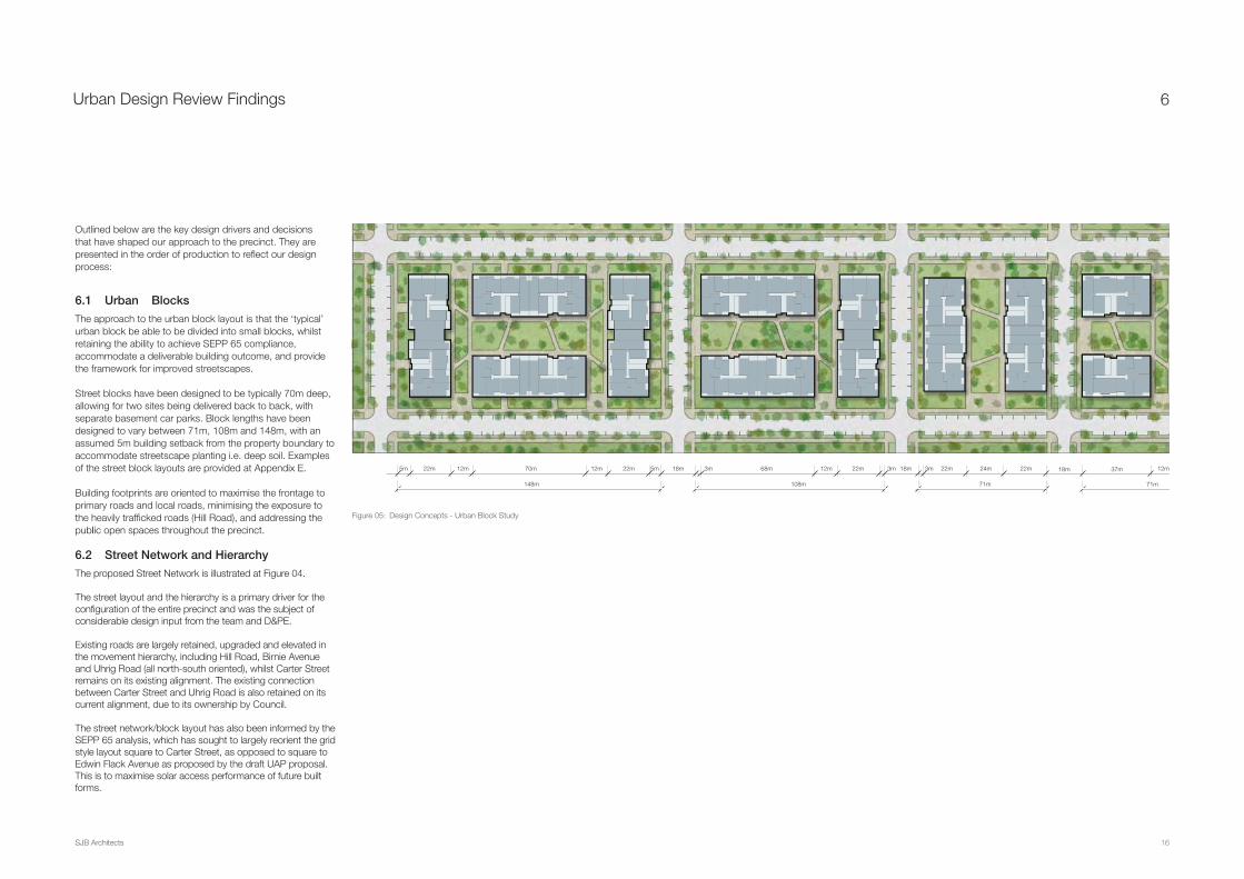
6.1 Urban Blocks
The approach to the urban block layout is that the ‘typical’ urban block be able to be divided into small blocks, whilst retaining the ability to achieve SEPP 65 compliance, accommodate a deliverable building outcome, and provide the framework for improved streetscapes.
Street blocks have been designed to be typically 70m deep, allowing for two sites being delivered back to back, with separate basement car parks. Block lengths have been designed to vary between 71m, 108m and 148m, with an assumed 5m building setback from the property boundary to accommodate streetscape planting i.e. deep soil. Examples of the street block layouts are provided at Appendix E.
Building footprints are oriented to maximise the frontage to primary roads and local roads, minimising the exposure to the heavily trafficked roads (Hill Road), and addressing the public open spaces throughout the precinct.
6.2 Street Network and Hierarchy
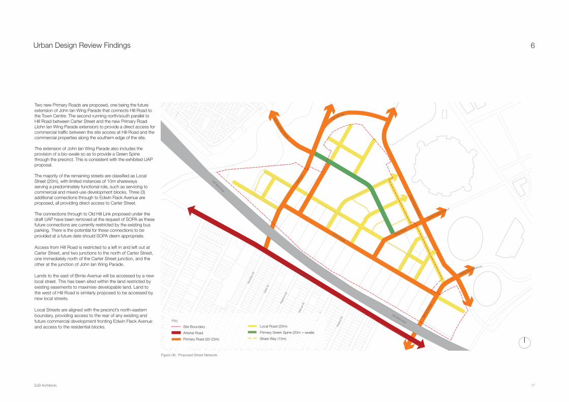
The proposed Street Network is illustrated at Figure 04.
The street layout and the hierarchy is a primary driver for the configuration of the entire precinct and was the subject of considerable design input from the team and D&PE.
Existing roads are largely retained, upgraded and elevated in the movement hierarchy, including Hill Road, Birnie Avenue and Uhrig Road (all north-south oriented), whilst Carter Street remains on its existing alignment. The existing connection between Carter Street and Uhrig Road is also retained on its current alignment, due to its ownership by Council.
The street network/block layout has also been informed by the SEPP 65 analysis, which has sought to largely reorient the grid style layout square to Carter Street, as opposed to square to Edwin Flack Avenue as proposed by the draft UAP proposal. This is to maximise solar access performance of future built forms.
SJB Architects
5m 5m 3m 3m 3m 18m18m18m 22m 24m22m70m 68m 37m22m 12m 12m 12m 12m
71m71m148m 108m
22m 22m
Figure 05: Design Concepts - Urban Block Study
17
Urban Design Review Findings
SJB Architects
Carter Street
M4 Motorway
Parramatta Road
Uhrig Road
Dawn Fraser Avenue
Birn
ie A
venu
e
Edwin Flack Avenue
Hill R
oad
Bom
bay
St
Del
hi S
t
Plat
form
St
Jellic
oe S
t
Mon
s St
Ost
end
St
Shane Gould Avenue
Old Hill Link
M4 Motorway
John Ian Wing Parade
6
Figure 06: Proposed Street Network
Two new Primary Roads are proposed, one being the future extension of John Ian Wing Parade that connects Hill Road to the Town Centre. The second running north/south parallel to Hill Road between Carter Street and the new Primary Road (John Ian Wing Parade extension) to provide a direct access for commercial traffic between the site access at Hill Road and the commercial properties along the southern edge of the site.
The extension of John Ian Wing Parade also includes the provision of a bio-swale so as to provide a Green Spine through the precinct. This is consistent with the exhibited UAP proposal.
The majority of the remaining streets are classified as Local Street (20m), with limited instances of 10m shareways serving a predominately functional role, such as servicing to commercial and mixed-use development blocks. Three (3) additional connections through to Edwin Flack Avenue are proposed, all providing direct access to Carter Street.
The connections through to Old Hill Link proposed under the draft UAP have been removed at the request of SOPA as these future connections are currently restricted by the existing bus parking. There is the potential for these connections to be provided at a future date should SOPA deem appropriate.
Access from Hill Road is restricted to a left in and left out at Carter Street, and two junctions to the north of Carter Street, one immediately north of the Carter Street junction, and the other at the junction of John Ian Wing Parade.
Lands to the east of Birnie Avenue will be accessed by a new local street. This has been sited within the land restricted by existing easements to maximise developable land. Land to the west of Hill Road is similarly proposed to be accessed by new local streets.
Local Streets are aligned with the precinct’s north-eastern boundary, providing access to the rear of any existing and future commercial development fronting Edwin Flack Avenue and access to the residential blocks.
J
Mon
s St
Mon
sM
ons
Moon
ss St
sSt
s StSt
Key
Site Boundary
Arterial Road
Primary Road (20-23m)
Local Road (20m)
Primary Green Spine (20m + swale)
Share Way (10m)
18
Urban Design Review Findings
SJB Architects
6
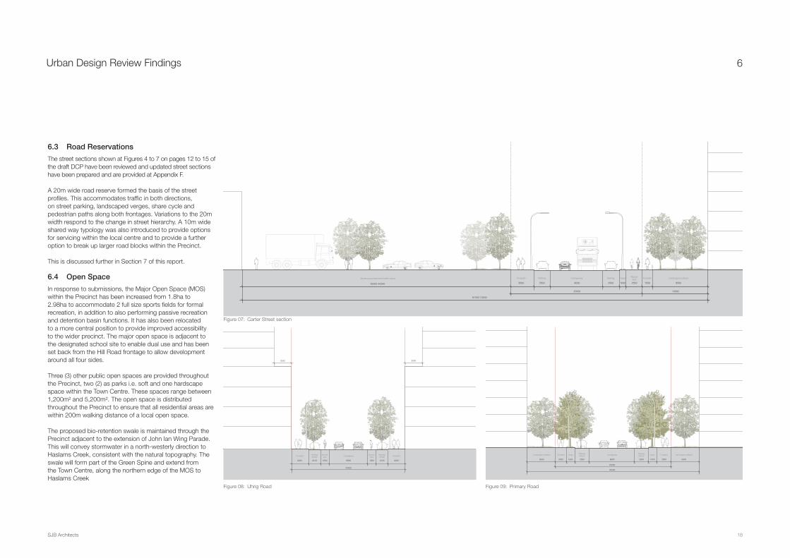
6.3 Road Reservations
The street sections shown at Figures 4 to 7 on pages 12 to 15 of the draft DCP have been reviewed and updated street sections have been prepared and are provided at Appendix F.
A 20m wide road reserve formed the basis of the street profiles. This accommodates traffic in both directions, on street parking, landscaped verges, share cycle and pedestrian paths along both frontages. Variations to the 20m width respond to the change in street hierarchy. A 10m wide shared way typology was also introduced to provide options for servicing within the local centre and to provide a further option to break up larger road blocks within the Precinct.
This is discussed further in Section 7 of this report.
6.4 Open Space
In response to submissions, the Major Open Space (MOS) within the Precinct has been increased from 1.8ha to 2.98ha to accommodate 2 full size sports fields for formal recreation, in addition to also performing passive recreation and detention basin functions. It has also been relocated to a more central position to provide improved accessibility to the wider precinct. The major open space is adjacent to the designated school site to enable dual use and has been set back from the Hill Road frontage to allow development around all four sides.
Three (3) other public open spaces are provided throughout the Precinct, two (2) as parks i.e. soft and one hardscape space within the Town Centre. These spaces range between 1,200m² and 5,200m². The open space is distributed throughout the Precinct to ensure that all residential areas are within 200m walking distance of a local open space.
The proposed bio-retention swale is maintained through the Precinct adjacent to the extension of John Ian Wing Parade. This will convey stormwater in a north-westerly direction to Haslams Creek, consistent with the natural topography. The swale will form part of the Green Spine and extend from the Town Centre, along the northern edge of the MOS to Haslams Creek
Footpath FootpathCarriageway
3500 8000
20000
67000-73000
1500
Landscaped setback
8500
10000
Infrastructure easement (width varies)
35000-40000
Parking
2500
Verge
1000
Parking
2500
Bicyclelane
2500
30003000
Footpath FootpathCarriageway
3000
Parking/WSUD
2100
Bicyclelane
15006800
20000
3000
Parking/WSUD
2100
Bicyclelane
1500 1500
Verge VergeFootpath FootpathCarriagewayParking/WSUD
2000 8000
30000
20000
2500
Parking/WSUD
2500 1500 2000
Landscaped setback
5000
Landscaped setback
5000
Figure 07: Carter Street section
Figure 08: Uhrig Road Figure 09: Primary Road

19
Urban Design Review Findings
SJB Architects
6
Figure 10: Proposed Public Open Space
A further 9,300m² of dedicated public open space is proposed in the form of a 20m wide linear reserve along the southern bank of Haslams Creek.
The public open space across the Precinct has a total area of approximately 4.75ha which equates to 14.1% of the residential developable area (33.6ha) or approximately 9% of the whole precinct. This calculation excludes the landscape setbacks along Carter Street, Hill Road/Old Hill Link and the M4 corridor which would be maintained in private ownership.
The existing public open space owned by Auburn City Council at the corner of Carter Street and Hill Road is excluded from the calculation due to its poor useability and the likelihood it will be compromised by future M4 works. It is proposed to remain RE1 Public Recreation in the interim, however there may be the potential for this space to be rezoned to B6 Enterprise Corridor as proposed for the adjoining employment land south of Carter Street, once road requirements have been determined.
A copy of the proposed public open space is illustrated in Figure 10.
6.5 School
The Indicative Structure Plan in the draft UAP identified that a new primary school would be provided within the Precinct. However, it did not identify a minimum site area for the school and the location was shown indicatively on the corner of two of the local streets adjacent to Hill Road.
The peer review has identified a 2ha site for the purposes of a school. We understand via DP&E that DEC are satisfied with this location. The site of the school is proposed to be zoned SP2 Infrastructure (School) to provide greater certainty.
The site of the school has been relocated further north from that identified under the draft proposal. This is a function of the amended road layout, relocation of the major open space and the identification of a potential site for the school adjacent to the existing cutting on the Goodman landholdings.
The school site maintains a co-location immediately adjacent to the major open space to enable dual use of the open space.
+8.0
+10.0
+12.0
+12.0
+14.0
+14.0
+16.0
+16.0 +18.0
+10.0
+6.0
+6.0
+4.0
+4.0
+2.0
0.2ha
0.12ha
2.98ha
School
Can
alInfrastructure easement
0.93ha
0.52ha
200m
200m
200m
200m
400m
Carter Street
M4 Motorway
Parramatta Road
Uhrig Road
Dawn Fraser Avenue
Birn
ie A
venu
e
Edwin Flack Avenue
Bom
bay
St
Del
hi S
t
Plat
form
St
Jellic
oe S
t
Mon
s St
Ost
end
St
Old Hill Link
M4 Motorway
Total site area 52.4 ha
Residential Developable area 33.6 ha
Public open space 4.75 ha
% Open space 14.1%
· Public open space excludes landscape setbacks · Developable area does not include lots designated for
commercial use
Hill R
oad
Shane Gould Avenue
John Ian Wing Parade
Je
Mon
s St
Site Boundary
Public Open Space
Landscape Buffer
Key Roads
Overland Flow Path
Detention Basin (Integrated)
Key

20
Urban Design Review Findings
SJB Architects
6
Carter Street
M4 Motorway
Parramatta Road
800m
400mUhrig Road
Dawn Fraser Avenue
Birn
ie A
venu
e
Edwin Flack Avenue
Hill R
oad
Bom
bay
St
Del
hi S
t
Plat
form
St
Jellic
oe S
t
Mon
s St
Ost
end
St
Shane Gould Avenue
Old Hill Link
M4 Motorway
John Ian Wing Parade
Figure 11: Proposed Indicative Structure Plan
6.6 Revised Indicative Structure Plan
The key observations or amendments to the Indicative Structure Plan relate to the following:
· Reorientation of the grid style street network layout was required square to Carter Street, as opposed to square to Edwin Flack Avenue, to maximise solar access performance of future built forms;
· Increase in the size and amended location of the major open space and relocation of the smaller ancillary open space areas;
· Relocation of the school site to the northern side of the major open space;
· Provision of a new intersection on Hill Road and east-west street to provide alternative access to the Precinct instead of Carter Street, as the Carter Street/Hill Road intersection is impacted upon by traffic congestion from the M4 and Parramatta Road access;
· Consolidation of the Local Centre land around Uhrig Road rather than extending along the southern side of Edwin Flack Avenue.
A proposed Indicative Structure Plan is illustrated in Figure 11.
Mon
s St
Ost
end
St
Key
Precinct BoundaryCatchment
ResidentialBusinessLocal Centre
Open SpaceLandscape Setback
Primary Route TowerFuture Link
Infrastructure Landscape Link

21
Urban Design Review Findings
SJB Architects
6
6.7 Setbacks
Consistent with the exhibited UAP proposal, setbacks are proposed to be used throughout the Precinct to establish the character of the different streetscapes and to achieve deep soil planting (refer to Figure 12).
Nil setbacks are provided in the town centre to promote activation and provide a differentiation in built form outcome. A 3m setback above the podium level is proposed for development along the eastern and western frontage of Uhrig Road and side streets/returns. The majority of the urban blocks feature a 5m setback. 3m setbacks are proposed along Local Streets likely to carry lower volumes of traffic, including the streets to the east of the town centre and connecting streets.
The adoption of 3m and 5m setbacks is to vary the character of the streetscapes throughout the precinct, reinforcing the character of individual sub-precincts, such as the area to the east of the town centre, the town centre itself and extension of John Ian Wing Parade.
A 10m setback is proposed along the drainage channel in the west of the site.
10m setbacks are proposed along Hill Road, Carter Street (north) and Birnie Avenue east to address issues associated with noise and traffic impacts. A 20m landscaped setback is maintained along the precinct’s southern boundary to the M4. The 40m landscaped setback to the M4 Motorway proposed for residential buildings under the draft UAP is proposed to be reduced to 20m as as no residential is proposed along the M4.
Carter Street
M4 Motorway
Parramatta Road
Uhrig Road
Dawn Fraser Avenue
Birn
ie A
venu
e
Edwin Flack Avenue
Hill
Roa
d
Hill R
oad
Bom
bay
St
Del
hi S
t
Plat
form
St
Jellic
oe S
t
Mon
s St
Ost
end
St
Shane Gould Avenue
Old Hill Link
M4 Motorway
John Ian Wing Parade
Figure 12: Proposed Illustrative Setbacks Plan
Je
Mon
s St
Key
10m setback20m setback3m setback above 3-6 storey podium
Precinct BoundaryInfrastructure easement2-storeys, 20m south of easement
No setback 3m setback 5m setback

22
Urban Design Review Findings
SJB Architects
6
Carter St
M4 MotorwayParramatta Road
Uhrig R
oad
Daw
n Fraser Avenue
Birnie Avenue
Edwin Flack Avenue
John Ian Wing Parade
Shane G
ould Avenue
Old H
ill Link
Key
R4 High Density Residential
B6 Enterprise Corridor
B2 Local Centre
RE1 Public Recreation
6.8 Building Heights
Building heights across the Precinct were restricted to a maximum of 30-storeys, which responds to and is comparable with the maximum proposed building heights within the Sydney Olympic Park.
Building heights were revisited with the view to creating a different character. The broad approach to building heights adopted was to locate taller buildings (i.e. towers) at gateways to the precinct and key destinations.
Towers are positioned at the south-eastern corner of the site to mark the entry points off Birnie Avenue, adjacent to the M4 Motorway. A cluster of three towers ranging from 20-30 storeys are proposed to mark the Uhrig Road Town Centre.
Buildings located to the north and along the eastern and western edges of the public open spaces are restricted to a maximum of 12-storeys to mitigate the impact of over-shadowing whilst maintaining an appropriate scale of development to contain the space.
Building heights, and some yields have been increased on the land-holdings to the east of Birnie Avenue and at the south-west corner as it was recognised that these sites had the potential to accommodate additional height and to provide a greater incentive to redevelop.
For the purposes of calculating building heights, the following heights were used:
· Residential - 3.2m floor to floor
· Retail/Commercial Ground – 4m floor to floor
· Retail/Commercial First Floor – 3.6m
· Commercial – 4m floor to floor
· Allowance for a 2m lift overrun.
The recommended building heights are illustrated at Figure 13.
Artist impression of the built form have been prepared and are attached at Appendix G.
Figure 13: Massing
23
Urban Design Review Findings
SJB Architects
6
6.9 Development Yields
The residential yield within the precinct would increase from the 5,500 indicated in the draft UAP proposal to over 6,069 dwellings as proposed in this peer review. This has been based on 606,873m² GFA and the assumed rate of 1 dwelling per 100m² of residential GFA.
The retail yield is a proposed GFA of 11,025m² as shown on the site layout plan, though it is noted that the building envelopes have the capacity to deliver more retail if required to meet the 12,000m² proposed by the UAP.
The extent of commercial land (i.e. B6 Enterprise Corridor) is recommended to be extended across the southern half of the Swire site given the constraints of the existing pipeline easements affecting this site. The B6 zoned land has the potential to deliver approximately 203,538m² GFA which will deliver approximately 6,785 jobs, based on the rate of 1 job per 30m².
Potential yields have been increased on the Swire site north to improve their developability.
Further breakdown of the development yields on a block-by-block and building-by-building basis is outlined in the schedule at Appendix D. A breakdown by specific land holdings is also provided at Appendix D. 6.10 Staging and Delivery
Street network and hierarchy, site layout plan and the urban structure plans have been revised to align with the Goodman lot boundaries and leasing plan to facilitate the deliverability of individual urban blocks.
Staging of development on the Goodman landholdings considers the even distribution of higher-density (tower) residential development in the earlier stages and provision of community uses and open spaces in the latter stages.
Roads have been aligned with the staging/lot boundaries to allow infrastructure and utilities to be delivered as part of the staged development.
Provision of open space and community uses (i.e. schools) distributed evenly across the stages 1-5, with the higher-density residential and town centre development proposed early, and the open spaces/schools proposed in the latter stages (4 and 5)
6.11 Planning Tools
Planning tools are used to control intensity of development and land use to achieve differentiation and character in our urban areas. The difficulty lies in the application of right tool and when using multiple tools ensuring that they match or complement one another.
The draft Proposal and associated planning framework proposes to amend the current planning framework under the Auburn LEP 2010 through a SEPP Amendment and amendments to the Landuse Zoning Map, Height of Buildings Map and Floor Space Ratio Map.
This peer review has reviewed each of the proposed maps and recommends changes to all three maps, to achieve greater definition of the local centre and the gateways to the Precinct.
6.11.1 Zoning
The peer review of the proposed zoning plan has generally sought to retain the proposed zoning throughout the precinct. Minor changes are proposed to reflect the proposed new structure plan. Open space is proposed to be zoned RE1 to fix the location of the proposed parks, as these open spaces also inform the future street layout. Similarly the future school is proposed to be zoned SP2 to fix the location of the school and surrounding street layout. The zone boundaries align with known locations such as existing cadastral boundaries and existing landforms.
It is noted that the B2 Local Centre zoning under the Auburn LEP 2010 permits the construction of standalone “residential flat buildings” within this zone. An active frontages control will need to be introduced in the key areas of the B2 zone to ensure that active frontages are achieved in such locations.
6.11.2 Height of Buildings
Detailed analysis of the land within the Precinct, individual land holding constraints, developable areas, built forms and building heights has informed the appropriate heights and FSRs for all landholdings.
The Height of Buildings Map has sought to provide greater variation in height than that under the draft UAP proposal, whilst still endeavouring to keep the Height of Buildings Map simple and allowing for variation of heights to ensure that not
all buildings are of the same height within each height area. However, the Height of Buildings Map has been prepared to ensure that the proposed FSR can be realised across the respective landholding and or each block.
6.11.3 FSR
It is important to note that the FSR control will be the determining factor. The FSR control will restrict development such that the maximum height cannot be achieved across the whole of an individual height area. The FSR control will therefore dictate a variety of heights within the Precinct.
The analysis has also tested how recommended FSRs apply to the whole site and as a potentially subdivided site, if development was to occur in a more fragmented way. Where new infrastructure is required to be delivered in accordance with a broad strategy, development site areas do not always correspond with the area available to be developed, which can result in different FSR’s if subdivision and infrastructure provision occurs early.
The FSR map (refer to Appendix H) provides FSR controls for the whole site, excluding any RE1 Public Recreation or SP2 Infrastructure zoned land.
It was noted in the peer review that several submissions from the landowners of the proposed B6 land requested an increase in FSR above the 1.5:1 to facilitate the redevelopment of their landholdings. However, as noted in the exhibited UAP Planning Report, the results of the Traffic Study and intersection modelling of the two main gateway intersections, identified that roads will begin to experience upstream queuing when the commercial development in Carter Street Precinct is approximately 55-65% of its full theoretical floor space. The Planning Report has assumed a 65% take up of the employment lands under the current proposal. In this respect, until such time as there are staged improvements to public transport and road networks, the FSR or height controls applicable to the B6 Enterprise Corridor zoned land are unable to be increased. It is envisaged that the FSR and height controls of the B6 corridor may be able to be reviewed in the future once road networks have been improved and a greater modal split to public transport is achieved.
6.11.4 Other
Other controls within the DCP will ensure that the appropriate character is achieved through street typologies, appropriate building setbacks and building lengths.
Recommendations on this suite of planning tools are provided in Section 7.

7 Planning Outcomes and Recommendations

25
Planning Outcomes and Recommendations
SJB Architects
7
7.1 SEPP Amendment
7.1.1 Zoning
The zonings recommended under the peer review broadly align with those outlined in the exhibited UAP. A copy of the proposed Land Zoning map is provided in Figure 14 and Appendix H. The key changes are:
· The size of the B2 Local Centre zoned land has been reconfigured in area and extends along Uhrig Road through the Town Centre to Carter Street. The eastern and western boundaries of the B2 Local Centre zoned land are inclusive of new local roads to be constructed, so that the zone boundaries reflect the proposed road pattern.
· The B2 Local Centre maintains a small urban plaza at its centre on Uhrig Road that is proposed to be zoned RE1 Public Recreation;
· RE1 Public Recreation zoned land has been amended to reflect the new park layouts. The main change being a larger public park (2.98ha) within the western half of the precinct;
· The school site has been proposed to be zoned SP2 Infrastructure (School) and includes part of a future street along the southern boundary, but otherwise is exclusive of future roads.
· The Sydney Water Pump Station (SPS) site at the western end of the precinct is proposed to be zoned RE1 Public Recreation. The SPS is still permissible in the RE1 zone under the SEPP (Infrastructure) 2007. It is noted that the RE1 land surrounding the SPS is not in public ownership.
· The strip of land between the M4 Motorway and No.12-14 Birnie Avenue currently zoned IN2 under the Auburn LEP 2010 and proposed to be rezoned to RE1 Public Recreation under the draft UAP, is proposed to be zoned B6 in response to the submission by Auburn Council.
It is noted that the land to be zoned RE1 Public Recreation and the SP2 School site will be subject to the acquisition clause.
Given the B2 Local Centre zone under the Auburn LEP 2010 permits standalone “residential flat buildings”, it is recommended that an active frontage control be implemented in the zone to ensure that active frontages are delivered in the important locations within the B2 zone. This is explained further in Section 7.1.5.
Recommendation:
· Update zoning map to reflect amended zoning map at Appendix H.
Carter Street
M4 Motorway
Parramatta Road
Uhrig Road
Dawn Fraser Avenue
Birn
ie A
venu
e
Edwin Flack Avenue
Hill
Roa
d
Hill R
oad
Bom
bay
St
Del
hi S
t
Plat
form
St
Jellic
oe S
t
Mon
s St
Ost
end
St
John Ian Wing Parade
Shane Gould Avenue
Old Hill Link
M4 Motorway
Figure 14: Proposed Land Zoning Map
Key
Precinct Boundary
R4 High Density ResidentialB6 Enterprise Corridor
B2 Local CentreRE1 Public RecreationSP2 Infrastructure

26
Planning Outcomes and Recommendations
SJB Architects
Figure 15: Proposed Heights of Buildings Map
7
7.1.2 Height of Buildings
The draft UAP proposal proposed five building height categories across the precinct, comprising: · 15m (4 storeys)
· 22.9m (6 storeys)
· 27m (8 storeys)
· 40m (12 storeys)
· 64m (20 storeys)
The majority of the residential land was subject to a 27m height control (8 storeys) with isolated 64m (20 storeys) landmark locations. South of Carter street was subject to the 22.9m (6 storey) height control.
The peer review recognised that there was little variation proposed in the height controls across the Precinct and that there was opportunity to deliver a variety of different heights across the precinct to reflect a varied built form.
A draft Height of Buildings Map illustrating the proposed height controls is provided at Figure 15 and at Appendix I.
The purpose of this is to achieve a varied building height and character throughout the Precinct. The heights have been translated into the following: · 24m (6 sotreys - commercial)
· 29m (8 storeys - residential)
· 42m (12 storeys)
· 55m (16 storeys)
· 68m (20 storeys)
· 100m (30 storeys)
Recommendation:
· Update the Height of Buildings Map to reflect the amended Height of Buildings Map in Appendix H.
Y(42m)
Y(42m) Y
(42m)
Y(42m)
T(29m)
Z(55m)
AA(68m)
AA(68m)
AA(68m)
AA(68m)
AB(100m)
S(24m)
S(24m)
S(24m)
Carter Street
M4 Motorway
Parramatta Road
Uhrig Road
Dawn Fraser Avenue
Birn
ie A
venu
e
Edwin Flack Avenue
Hill
Roa
d
Hill R
oad
Bom
bay
St
Del
hi S
t
Plat
form
St
Jellic
oe S
t
Mon
s St
Ost
end
St
Shane Gould Avenue
Old Hill Link
M4 Motorway
John Ian Wing Parade
Key
Precinct Boundary 24m
29m
42m
55m
68m
100mT
AAS
Z
Y
AB

27
Planning Outcomes and Recommendations
SJB Architects
1.75:1
2.5:1
2.5:1
3.25:1
3.5:1
3.5:1
3.25:1
1.75:1
1.5:1
1.5:1
1.5:1
4:1
2.5:1
2:1
2:1
2:1
Carter Street
M4 Motorway
Parramatta Road
Uhrig Road
Dawn Fraser Avenue
Birn
ie A
venu
e
Edwin Flack Avenue
Hill
Roa
d
Hill R
oad
Bom
bay
St
Del
hi S
t
Plat
form
St
Jellic
oe S
t
Mon
s St
Ost
end
St
Shane Gould Avenue
Old Hill Link
M4 Motorway
John Ian Wing Parade
Note: Calculated on zoned site area onlyExcludes RE1 Lands
7
7.1.3 Floor Space Ratio
The draft UAP proposed FSRs of 1.5:1 across the B6 Enterprise Corridor zoned land and 2.0:1 across the R4 High Density Residential and B2 Local Centre parts of the precinct, with the exception of the land west of Hill Road which was proposed at 1.5:1.
The peer review has sought to achieve a 2:1 FSR yield across the combined residential development site areas, and on the individual land-holdings. This equates to approximately 200 dwellings per hectare or 6,600 dwellings across the 33.6ha. However, after further analysis of building heights and modelling of floor space, the peer review has identified that the proposed R4 Residential and B2 Local Centre zoned part of the Precinct could accommodate approximately 6,069 dwellings. The FSR has been amended to reflect the change in built form outcomes and to marry with the proposed changes in building heights. The resultant FSR’s range from 1.5:1 to 4:1. It is noted that the FSR control will limit the extent of development yield on a site and will result in varied heights within each site rather than all buildings achieving the maximum height control.
No change has to be made to the B6 Enterprise Corridor FSR due to the local and regional road/traffic constraints.
A draft FSR map illustrating the proposed FSR across the whole of the precinct is provided at Figure 16 and Appendix H.
Recommendation:
· Update the FSR map to reflect the amended FSR Map at Appendix J.
Figure 16: Proposed Floor Space Ratio Map
Key
Precinct Boundary1.5-1.75:12:12.5:1
3.25:13.5:14:1

28
Planning Outcomes and Recommendations
SJB Architects
7
Site 4
Site 1
Site 2
Site 5
Site 3
Carter Street
M4 Motorway
Parramatta Road
Uhrig Road
Dawn Fraser Avenue
Birn
ie A
venu
e
Edwin Flack Avenue
Hill R
oad
Bom
bay
St
Del
hi S
t
Plat
form
St
Jellic
oe S
t
Mon
s St
Ost
end
St
Shane Gould Avenue
M4 Motorway
7.1.4 Key Sites
The peer review recommends the identification of five (5) key sites within the precinct through the use of a Key Sites Map. These five (5) sites are proposed to have height controls of 20 or more storeys and are typically the gateway or landmark sites that form the markers within the Precinct.
The key sites are sized to include the immediately adjoining roads or parks. The purpose of the Key Sites Map is to ensure that a higher level of design quality is achieved on the landmark buildings and require a Stage 1 DA, to ensure that varied built form is achieved on the landmark sites. It is noted that the Auburn LEP 2010 has a Key Sites Map, so any provisions applying to key sites within the Carter Street Precinct will need to be distinguished from any existing provisions applying to the existing Key Sites Map.
A copy of the proposed Key Sites Map is provided at Figure 17 and attached at Appendix H.
Figure 17: Key Sites Map
Precinct Boundary
Key Site
Key

29
Planning Outcomes and Recommendations
SJB Architects
7
Recommendation:
· Include a Key Sites Map in the SEPP Amendment.
· Any development on these sites be the subject of a Stage 1 DA to establish the building heights, massing and delivery of infrastructure. This could be achieved through the following clause.
7.20 Development requiring preparation of a development control plan
(1.) This clause applies to any of the following development:(a.) development for the purposes of a new building,(b.) development that increases the gross floor area of
an existing building.(2.) Development consent must not be granted to
development to which this clause applies on the following land unless a development control plan that provides for the matters in subclause (4) has been prepared for the land:(a.) land identified as a “Key Site” and shown edged
heavy black and distinctively coloured on the Key Sites Map
(3.) A development control plan is not required to be prepared if the consent authority is satisfied that such a plan would be unreasonable or unnecessary in the circumstances or that the development:(a.) involves only alterations or additions to an existing
building, and(b.) does not significantly increase the height or gross
floor area of the building, and(c.) does not have significant adverse impacts on
adjoining buildings or the public domain, and(d.) does not significantly alter any aspect of the
building when viewed from public places.
(4.) The development control plan must provide for all of the following:(a.) requirements as to the form and external
appearance of proposed development so as to improve the quality and amenity of the public domain,
(b.) requirements to minimise the detrimental impact of proposed development on view corridors,
(c.) how proposed development addresses the following matters:
(i.) the suitability of the land for development,(ii.) the existing and proposed uses and use
mix,(iii.) any heritage issues and streetscape
constraints,(iv.) the location of any tower proposed,
having regard to the need to achieve an acceptable relationship with other towers (existing or proposed) on the same site or on neighbouring sites in terms of separation, setbacks, amenity and urban form,
(v.) the bulk, massing and modulation of buildings,
(vi.) street frontage heights,(vii.) environmental impacts, such as sustainable
design, overshadowing and solar access, visual and acoustic privacy, noise, wind and reflectivity,
(viii.) the achievement of the principles of ecologically sustainable development,
(ix.) pedestrian, cycle, vehicular and service access and circulation requirements, including the permeability of any pedestrian network,
(x.) the impact on, and any proposed improvements to, the public domain,
(xi.) the impact on any special character area,(xii.) achieving appropriate interface at ground
level between the building and the public domain,
(xiii.) the excellence and integration of landscape design,
(xiv.) the incorporation of high quality public art into the fabric of buildings in the public domain or in other areas to which the public has access.
Note. Section 83C of the Environmental Planning and Assessment Act 1979 provides that if an environmental planning instrument requires the preparation of a development control plan before any particular or kind of development is carried out on any land, that obligation may be satisfied by the making and approval of a staged development application in respect of that land.
· Any Development Applications for these sites be reviewed by a Design Review Panel and require Design Excellence. This could be achieved through a clause along the lines of the following:
7.5 Design excellence
(1.) This clause applies to the following development on land to which this clause applies.(a.) the erection of a new building, or(b.) additions or external alterations to an existing
building that, in the opinion of the consent authority, are significant,
(2.) The clause applies to site identified as a “Key Site” and shown edged heavy black and distinctively coloured on the Key Sites Map
(3.) Development consent must not be granted for development to which this clause applies unless the development has been considered by a Design Review Panel.
(4.) Development consent must not be granted for development to which this clause applies unless the consent authority considers that the development exhibits design excellence.
(5.) In considering whether the development exhibits design excellence, the consent authority must have regard to the following matters:(a.) whether a high standard of architectural design,
materials and detailing appropriate to the building type and location will be achieved,
(b.) whether the form and external appearance of the development will improve the quality and amenity of the public domain,
(c.) how the development addresses the following matters:
(i.) heritage issues and streetscape constraints,(ii.) the location of any tower proposed,
having regard to the need to achieve an acceptable relationship with other towers (existing or proposed) on the same site or on neighbouring sites in terms of separation, setbacks, amenity and urban form,
(iii.) bulk, massing and modulation of buildings,(iv.) street frontage heights,(v.) environmental impacts such as sustainable
design, overshadowing, wind and reflectivity,(vi.) the achievement of the principles of
ecologically sustainable development,(vii.) pedestrian, cycle, vehicular and service
access, circulation and requirements,(viii.) the impact on, and any proposed
improvements to, the public domain.
(6.) In this clause:
Design Review Panel means a panel of 2 or more persons established by the consent authority for the purposes of this clause.

30
Planning Outcomes and Recommendations
SJB Architects
7
7.1.5 Active Street Frontages
The Auburn LEP 2010 permits stand alone “residential flat buildings” within the B2 Local Centre zone. To ensure that active street frontages are delivered along the key frontages within the proposed Uhrig Road local centre, it is recommended that an active frontage control be implemented.
A draft Active Street Frontages Map is provided at Figure 18 and attached at Appendix H.
The map will also need to be supported by an Active Street Frontages clause.
6.6 Active street frontages
(1.) The objective of this clause is to promote uses that attract pedestrian traffic along certain ground floor street frontages.
(2.) This clause applies to land identified as “Active Street frontage” on the Active Street Frontages Map.
(3.) Development consent must not be granted to the erection of a building, or a change of use of a building, on land to which this clause applies unless the consent authority is satisfied that the building will have an active street frontage after its erection or change of use.
(4.) Despite subclause (3), an active street frontage is not required for any part of a building that is used for any of the following:(a.) entrances and lobbies (including as part of mixed
use development),(b.) access for fire services,(c.) vehicular access.
(5.) In this clause, a building has an active street frontage if all premises on the ground floor of the building facing the street are used for the purposes of business premises or retail premises.
Carter Street
M4 Motorway
Parramatta Road
Uhrig Road
Dawn Fraser Avenue
Birn
ie A
venu
e
Edwin Flack Avenue
Hill
Roa
d
Hill R
oad
Bom
bay
St
Del
hi S
t
Plat
form
St
Jellic
oe S
t
Mon
s St
Ost
end
St
Shane Gould Avenue
Old Hill Link
M4 Motorway
John Ian Wing Parade
Figure 18: Proposed Active Street Frontages Map
Key
Active street frontage

31
Planning Outcomes and Recommendations
SJB Architects
7
7.2 DCP Amendments
The key changes to the DCP to be recommended from the urban design review relate to the following:
· Typical Street Sections
· Indicative Structure Plan/All diagrams
7.2.1 Typical Street Sections
Typical Street Sections at Figures 4 to 7 on Pages 12 to 14 of the DCP are to be updated to reflect the new street sections provided at Appendix F.
7.2.2 Other Changes
Otherwise the following changes will be required: · Update Table 1 Key Elements to reflect the amended plans
· Replace Figure 2 with new Structure Plan
· Replace Figures 3 to 8
· Update Open Space Controls 1, 3 and 4
· Replace Figure 9 Public Spaces
· Delete Figure 10 Uhrig Road Village Park
· Update 4.1 Building Height and Form Controls 1 and 3 to better reflect the new plans
· Amend 4.1 Building Height and Form Control 3.
4.1(3) currently states:
Buildings of 12 storeys and above are to meet the following requirements: · Be located at least 60 metres from any other building of
10 storeys or above · Be located to minimise overshadowing on public land
and communal open space · Have a maximum individual building footprint of 750m² · Incorporate a semi podium to soften street presence · Have a strong vertical emphasis in façade articulation
This wording of 4.1(3) of the Draft DCP is considered too onerous as it requires buildings over 12 storeys to have 60m separation from other 12 storey buildings and restricts building footprints to 750m².The 60m separation requirement is considered excessive and too onerous as it significantly exceeds the separation requirements of SEPP 65. Furthermore, a 60m separation would affect the ability to provide taller buildings in key locations and would potentially trigger larger street blocks so as to accommodate taller buildings, in turn reducing the permeability within the Precinct.
The requirement for buildings over 12 storeys to have a maximum building footprint of 750m² is considered onerous. A 750m² footprint limit is appropriate in the City of Sydney LGA in the more confined city context. However given the size of the landholdings within the Precinct, there is sufficient capacity to accommodate larger buildings without the detrimental impacts on surrounding or neighbouring properties. A maximum building footprint of 950m² is considered appropriate for this location. A 950m² footprint translates into a GFA of approximately 700m², which equates to approximately 7 to 10 dwellings per level and will require 3-4 lifts depending on the height of the building.
Notably, if the increased yield as proposed under this peer review is to be retained, building heights would have to be significantly increased, if a 750m² maximum building footprint control is to be maintained.
· It is recommended that 4.1(3) of the DCP be amended to read as follows:
“Buildings of 12 storeys and above are to meet the following requirements: · be located to minimise overshadowing on public and
communal open space · have a maximum individual building footprint of 950m² · incorporate a semi-podium to soften street presence · have a strong vertical emphasis in façade articulation”
· Amend 4.2 Setback controls to reflect amended setbacks.
· Section 4.2 Control 12 – This control in the draft exhibited DCP seeks to encourage non-residential uses on the ground floor along Hill Road and the John Ian Wing Parade extension. It is recommended that this control not apply to Hill Road as it will encourage on street car parking along the Hill Road frontage, which is not available due to the traffic constraints of Hill Road. It is also recommended that it not appy to the John Ian Wing Parade extension, as the amended Precinct Layout Plan no longer identifies this road as a key road.
It is recommended that this control be amended to delete reference to non-residential uses on ground floor along Hill Road and Ian Wing Road, so that the control only relates to the B2 Local Centre zoned land.
· Replace Figure 12.