urban design element - san diego · urban design 247 urban design urban design is a process to...
TRANSCRIPT

URBAN DESIGN ELEMENT

URBAN DESIGN 247
Urban Design Urban Design is a process to foster environmental quality as the City changes. It is the complex interaction of physical and psychological factors relating to our urban environment. In a real sense, urban design provides the sense of place, of diversity and of distinctiveness so often lacking in land use plans. "How does a city face what is really a massive socio-esthetic catastrophe? How does it keep its individual quality and style against the onslaught of scaleless, qualityless, value-destroying, speculative construction that produces pedestrian look-alikes and disaffected citizens without pride of place or community?. . . How do you help cities to think about the problem and to devise answers; ways to exercise the 'city option' of style, quality and continuity that make a satisfying and identifiable place to live"? Ada Louise Huxtable "Lessons in How to Heal the City's Scars" "The concept of the public welfare is broad and inclusive. The values it represents are spiritual as well as physical, aesthetic as well as monetary. It is within the power of the legislature to determine that the community should be beautiful as well as healthy, spacious as well as clean, well-balanced as well as carefully patrolled." U.S. Supreme Court, 1954 Berman vs. Parker, 348 US 26, 75 Supreme Court 98, Ed. 27 (1954) The pattern of a city is the visual framework composed of the natural base upon which the city rests, together with the built or man-made environment. The pattern is not rigid but rather one of balance and compatibility with diverse and random features fitting together to form the whole. The pattern of San Diego's appearance is perhaps the basis of the city's quality. San Diego will grow and change, but the City is already here and what is here will continue to be a major determinant of form and quality. A careful look at what should be saved and repaired in the existing City is the first task. Conservation of the natural setting is an urgent priority as is preserving the older parts of the City. Much of the City needs repair and restoration in varying degrees. As in any city that has grown fast, mistakes have been made. Public use and public access have been preempted. The public environment is all too often simply the leftover space between. The Urban Design Element deals with the preservation, rehabilitation, and reuse of existing man-made facilities. The element also addresses the integration of new development with the natural landscape or within the framework of an existing community, with minimum impact on that community's physical and social assets. The Urban Design Element will also serve as a springboard for innovative legislation to deal with development more effectively than present controls do.

URBAN DESIGN 248
This element is vital in implementing logical and planned growth as well as cohesiveness between all other elements in the General Plan. The various elements address the quality, location, timing and sequence of development and facilities, but they do not necessarily address the issue of form and human feeling that new development should take, nor do they describe an ideal to which new development should aspire. These issues are urban design issues. Implementation of the other elements of the General Plan alone will not improve the quality of the environment, but the combination of these elements carried out under the guidance of the criteria of the Urban Design Element will more fully address that quality. An Image of San Diego FINDINGS The image of the City can be more fully defined as environmental cognition. It refers to the awareness, images, information, impressions, and beliefs that individuals and groups have about the elemental, structural, functional, and symbolic aspects of real and imagined physical, social, cultural, economic, and political environments. The image most people have of San Diego is generally positive and full of affection. The physical setting appears as the most important feature. The City's site, its openness, its sun and mild climate, the sea and the contrasts of the landscape are unique assets. However, this setting is being destroyed. Development here is a copy of development everywhere in this country, rather than a pattern suited to the needs of San Diego. Freeways, arterial streets, airports, industrial areas and shopping centers, all look familiar. The newer residential areas are quite the same. It is only in the older communities where a character has evolved which is comfortable and humane. The image of the City is composed of the balance of many features fitting together to form the whole. These features consist of:
Water, the Ocean and San Diego and Mission Bays which are an edge of the City and a part of this climate and lifestyle. The water is open space, a focus of major view and a place of human activity.
Mesas, Canyons and Hillsides which allow the City to be seen, define communities and neighborhoods and which give communities an opportunity to be unique.
Streets and Highways which determine in many cases the character of development, accommodate man's movements and joins the communities of the City.
Residences, which occupy more of the land in San Diego than any other single use. Most neighborhoods are of good quality, varied and well maintained. However many large single-family housing areas tend to be monotonous and lack distinctiveness. Monotony is most acute in the newer areas containing many houses of similar age.

URBAN DESIGN 249

URBAN DESIGN 250
Zoning and subdivision practices promoting uniform development have encouraged endless repetition of house styles. In addition many current codes were written long after much of our existing housing was built, and their excessive standards now frustrate our avowed conservation objectives.
Other Buildings and Structures and clusters of them, which reflect the character of communities and centers of activity, provide reference points for human orientation and may add to (but can detract from) topography and views.
The image of the City has important psychological effects upon its residents. It provides organization and measured relationships that give a sense of time and place and reduce the amount of stress in urban life. Views on a pleasant and varied pattern give a comforting sense of living with the environment.
The image also helps people to identify communities and neighborhoods, particularly those in which they themselves live. Recognition of such areas by their prominent features,

URBAN DESIGN 251
their edges and their centers for activity breaks up a large and intense City into units that are visually and psychologically manageable. Furthermore, awareness of communities and neighborhoods increase the pride in one's area and in one's own life.
GOAL • DEVELOPMENT OF A COMPREHENSIVE CONCERN FOR THE VISUAL AND
OTHER SENSORY RELATIONSHIPS BETWEEN PEOPLE AND THEIR ENVIRONMENT.
GUIDELINES AND STANDARDS • RECOGNIZE AND PROTECT MAJOR VIEWS IN THE CITY WITH PARTICULAR
ATTENTION TO THOSE OF OPEN SPACE AND WATER.

URBAN DESIGN 252
Views contribute immeasurably to the quality of the City and to the lives of its residents. Protection should be given to major views whenever it is feasible, with special attention to the characteristic views of open space and water that reflect the natural setting of the City and give a colorful and refreshing contrast to man's development. • RECOGNIZE THAT BUILDINGS, WHEN SEEN TOGETHER PRODUCE A TOTAL
EFFECT THAT CHARACTERIZES THE CITY AND ITS COMMUNITIES. The relationships of building forms to one another, to other elements of the City image and to the City's residents should be moderated so that effects will be complementary and harmonious. The general pattern of development should emphasize the topographic form of the City and the importance of centers of activity. Structures should stand out prominently in the City scape only when they signify the presence of important community facilities and occupy visual focal points that benefit from buildings and structures of such design. • EMPHASIZE THE UNIQUE CHARACTER OF EACH COMMUNITY. The design of public improvements and to some extent those for private properties as well, should capitalize on opportunities to emphasize the distinctive nature of communities and neighborhoods. Landscaping can take into account differences in climate among communities. Distinctiveness can also be imparted by preservation and high lighting of topographic and architectural features common to an area and recognition of the diversity of life styles and preferences of the various groups that make up the City.
• PROTECT AND PROMOTE OPEN SPACE SYSTEMS THAT DEFINE
COMMUNITIES. Visually prominent features such as drainage basins, canyons, hillsides and floodplains often define the edges of communities and neighborhoods. They can create an awareness of areas within the total City framework and should be reinforced.

URBAN DESIGN 253
• INCREASE THE VISIBILITY OF MAJOR DESTINATION AREAS AND OTHER POINTS FOR ORIENTATION.
The design of streets, the determination of street use and the control of land uses and building types along streets should all be carried out with the visibility of such orienting features taken into account. Views from streets and other public areas should be preserved, created, and improved where they include the water, open space, large buildings and other major features. • RECOGNIZE THE RELATIONSHIP OF LAND TO STRUCTURE AND THE NATURE
AND IMPORTANCE OF THE NATURAL LANDFORMS AND THE NATURAL EVIRONMENT.
If a new form must be given to the land, the final form should have a strong, smoothly flowing character typical of the existing hills. The basic character of the original site should provide the theme with adjustments to make the slopes gentle. Particular attention should be paid to the transition areas where the existing terrain stops and earthwork begins. • CONTINUE SYSTEMATIC REVIEW AND EVALUATION OF THE CITY'S ZONING,
SUBDIVISION, AND BUILDING REGULATIONS TO ENSURE A CONSCIOUS CHOICE OF THE BEST OF AVAILABLE OPTIONS, INSTEAD OF MERE SATISFACTION OF MINIMUM STANDARDS.

URBAN DESIGN 254
The development process should, insofar as possible, be shaped by planning and regulatory bodies, lenders, accountants, appraisers, and other participants so that developers, homebuyers, and other consumers come to perceive the maintenance and enhancement of the quality of the environment as the key to profitability. The two colors on a checkerboard appear to advance or recede one from the other from time to time. This is an instance of the optical phenomenon known as figure ground. The dominant color is referred to as the figure, the other as the ground. The relationship between hillside structures and hillside vegetation is such a figure ground relationship. When the hillside can be read as the ground within which the figure rests, the hillside will retain its natural visual appearance. When development is so dominant that it becomes the ground, the hillside character has irreversibly changed.
Natural site vegetations is the ground
Development starts, structures is the figure.
Development continues. Equilibrium
attained.
Figure/Ground reverses. Hillsides lose character.
• EVALUATE DISCRETIONARY ACTIONS THAT RELATE TO PLANNING, URBAN
DESIGN AND IMPACT CRITERIA RATHER THAN EQUITY-TYPE VARIANCE FINDINGS:
• That the location, size, design, and operating characteristics of the site and the proposed
development will be compatible with and will not adversely affect the livability or appropriate development of abutting properties and the surrounding neighborhood. With consideration to be given to harmony in scale, bulk, coverage, and density, to the availability of civic facilities and utilities, to the harmful effect, if any, upon desirable neighborhood character, to the generation of traffic and the capacity and physical character of surrounding street, and to any other relevant impact of the development;
• That the location, design, and planning of the site and the proposed development will
provide a convenient and functional living, working, shopping, or civic environment, and will be as attractive as the nature of the use and its location and setting warrant;
• That the proposed development will enhance the successful operation of the
surrounding area in its basic community functions, or will provide an essential service to the community or region.

URBAN DESIGN 255
RECOMMENDATIONS • Prepare guidelines for the systematic consideration of visual and sensory quality in making
environmental impact statements. • Develop water conserving techniques and guidelines for planting, grading and landscaping
management. • Study major City views and important approaches with guideline for their protection and
enhancement. • Coordinate the design of street improvements and building features through cooperative
efforts by property owners and public agencies and through community planning. • Prepare an evaluation of perceived access to, and use of, the amenities of the City by
different social groups, and recommendations for more equitable distribution. The Natural Base In the urban environment of San Diego, there are parts of the natural landscape that have not changed. These features, the valleys and canyons and the shoreline, provide a feeling and relief from the crowding and stress of City life. As the City grows the keeping of these features becomes more difficult. Preservation and enhancement programs must be undertaken if the City is to keep a sense of unspoiled nature for future generations. FINDINGS The Valleys and Canyons The valleys, canyons, and hillsides are San Diego's priceless assets. The flat-floored valleys hold the water and the vegetation, and have been left open until recently, since new housing has avoided the floodplain and occupied high mesas. But now the valleys are facing development pressures despite the flood dangers. Fingering out from the long valleys, the narrow, brushy canyons, too steep for building, penetrate the City. They are a naturally connected system of open space that is close to almost every community. Many canyons show signs of use by local children, and a few have walking trails. Most lie unused - inaccessible to their neighborhoods, in many cases severed from these neighborhoods by urban development at their base where they connect to the valleys. Heavy machinery can fill them over or terrace them to make flat building sites. But cost, flood danger, erosion, and respect for the land all argue against tampering with this natural drainage system. Development trends in recent years have brought about many problems. Technological progress has dealt more with quantity rather than quality. Man has resculptured the terrain, remaking the environment, resulting in a sterile landscape. Constantly expanding development has eradicated
URBAN DESIGN 256
the unique character and identity of natural land forms. For miles in each direction neighborhoods and their houses become virtually indistinguishable. The Shoreline Many people value the ocean shore as the most important asset of the City. Although much of San Diego's shore is in public ownership, some of that is military ownership, and in other cases access is difficult because of the steep slopes, indirect routes, or the possessiveness of local shore communities. San Diego has a fairly wide range of income and housing in its coastal neighborhoods, but economic realities pressure for higher densities and higher rents. Some large buildings have been constructed, strongly objected to by beach communities who feared a solid line of structures walling off the shorelines. Concern over this possibility precipitated the passage of Propositions "D" (30 foot coastal height limit) and 20 (The California Coastal Initiative), in 1972. Unfortunately, the 30 foot height limit has done little toward resolving the problem of "walling off,” since if height is not permitted, the bulk of the building will expand to achieve the same desired and permitted density. An alternative could be the development of performance standards which would deal with variations of particular circumstances. The Silver Strand, the logical beach to serve the South Bay communities, is mostly under Navy control and the approach is circuitous and expensive. San Diego Bay, a unique and intimate expanse, has limited accessibility. Ocean Beach, Mission Beach, and the La Jolla shore are heavily used but parking is difficult. The bluffs at Torrey Pines shelter a magnificent strand, ideal for vigorous people willing to climb down to it, but inaccessible to others. The basic question to be answered is how much of the shore should be accessible to whom, and by what means. Shore communities should not have exclusive rights, nor should tourist accommodations be able to appropriate special frontages. The diversity of beach character and diversity of access should be maintained. There should be less reliance on the car, and more on the feet, or by bicycles and public transportation. GOAL • PRESERVE THE NATURAL BASE OF THE CITY; THE VALLEYS, CANYONS, HILL-
SIDES AND SHORELINE BY ENCOURAGING DEVELOPMENT TO RESPECT A VANISHING RESOURCE.
GUIDELINES AND STANDARDS The Valleys, Canyons and Hillsides • MAINTAIN THE CHARACTER OF THE UNDEVELOPED VALLEYS, CANYONS
AND HILLSIDES.

URBAN DESIGN 257
Confine development to the mesas and less sensitive areas of the canyons and protect the hillsides and rims, as well as the floor, so that the rural character of the valley or canyon is preserved, and erosion and flood damage is prevented. Floodplain and hillside zoning must be much more tightly drawn and specifically applied. Structures should be kept back from the rims, with few exceptions. Valley sides should be left to their natural vegetation, and the valley floors should be devoted to open space uses which are unharmed by flood. No further channeling of the streams should be permitted. • VALLEYS AND CANYONS SHOULD NOT BE CONSIDERED AS RIGHT-OF-WAY
FOR HIGHWAYS AND FUTURE TRANSIT LINES UNTIL ALL OTHER ALTERNATIVES HAVE BEEN EXPLORED.
Grading Principles The steeper the natural slope, the more severe the cut and fill required to produce level areas and the higher the resulting banks. Therefore, in steep terrain: • Lower the requirements for level areas; e.g., narrower streets, smaller yards, etc, • Make level areas in smaller increments to minimize bank height; e.g., split streets, multi-
level houses and yards, etc. • Create level areas by structure rather than by grading on extreme slopes; e.g., platform
houses, decks, etc. In level terrain: • Create interest by building up earth forms. In all terrain: • Preserve smooth flowing planes in the ground form. Steep slopes are difficult to plant and
maintain and nature breaks down sharp edges, so avoid them in the first place. Not only do highways destroy the natural character, they inevitably bring further development. The uses which most need their access are above, on the mesas, and this means even more ramps to get up there. Except for short local routes serving valley uses, roads should cross canyons and valleys at right angles, SAN DIEGO HAS A UNIQUE OPPORTUNITY TO DEVELOP AS A TWO-LEVEL CITY - ONE LEVEL A GREENWAY UNDISTURBED BY CITY TRAFFIC. • PARTS OF THE VALLEY AND CANYONS SHOULD BE ECOLOGICAL
PRESERVES. OTHERS, CAMPGROUNDS AND PARK LANDS FOR CHILDREN TO EXPLORE.

URBAN DESIGN 258
Agricultural, recreational and educational uses could be located there, wherever the natural character can be maintained. But uses which mean large gatherings and extensive parking lots - even public - do not belong.
Make level areas in smaller increments.
Avoid harsh, easily eroded forms and high, steep banks.
Make level areas in smaller increments.
Create level areas by structure rather than grading.
In level terrain, create interest by building earth forms.
Retain smooth flow of ground form: minimize steep slopes.

URBAN DESIGN 259
A COMPLETE TRAIL SYSTEM - FOR WALKING, CYCLING, AND HORSEBACK RIDING - SHOULD BE DEVELOPED ALONG THESE NATURAL VALLEYS.
Since they penetrate the region at regular intervals and run from mountains to sea on easy grades, they are ideal for recreational travel, and might even be a component in the movement of bicycle commuters. Selected canyons could be developed as connectors between the communities and the valleys, while others could serve for strolling, exploration and local connections. • ALLOW FOR A REASONABLE USE OF HILLSIDE AREA. Sensitive development, built in a way which complements the natural character of hillsides and relates well to the regional open space system, should be encouraged. Environmental resources, significant public views and a clear sense of hillside topography must be protected. Re-contour rather than cut and fill if earth moving is necessary. The Shoreline • NEW DEVELOPMENT SHOULD BE BACK FROM THE WATER'S EDGE. Whenever possible, development of vacant land and redevelopment should be at least 100 yards back of the beach or shore and set well behind the brow of the bluff. In many places it should be set farther back. Forward of that line, the land should be given to water-related public recreation, or occasionally leased to low and moderately-priced commercial recreation open to the general public. Where possible parking should be kept on the inland side of shoreline roads. • MAKE THE BEACHES ACCESSIBLE WITHOUT DESTROYING THE LOCAL
COMMUNITIES BEHIND THEM. Major transportation and parking should be kept well back of the beach, with frequent foot access. Elephant trains, bicycles, mini-buses, and boardwalks should predominate along the coast, reaching back to the major routes, while discreet public access routes run down the bluff faces. Continuous shore roads are not needed, but connected cycle and foot trails run along the

URBAN DESIGN 260
ocean, both behind the strand and along the rim of the bluffs. • ENCOURAGE HOUSING OF MIXED PRICE AND TYPE TO LOCATE ALONG
THE SHORE.
Densities should be allowed to increase moderately in this zone in accordance with adopted community plans, but bulk and character must be controlled. The existing mix of income should be protected, and a mix ensured in any new development. Quotas of low and moderately priced housing may have to be imposed, for the privilege of developing shore-front property. Residential use, and its attendant services, and small scale employment should be the natural disposition of coastal land, except where there are fragile estuaries to be maintained in their natural condition.
• CONTROL THE HEIGHT AND BULK OF SHOREFRONT DEVELOPMENT. Tall buildings and bulky low scale structures block views and impair access. In general, buildings should be low at the beach, and higher up on the bluffs and mesas in order to give everyone a look. Buildings close to the water should be limited in their dimensions parallel to the shore. Stairs, plantings, and other works on the highly visible face and rim of the bluff should be controlled to maintain the natural aspect. At the same time and while maintaining their intimate character, residential densities could be increased in many beach communities. Prototype designs for shoreline residence and for combinations of recreational and residential use should be examined. • PRESERVE THE HISTORICAL ASPECT OF THE SAN DIEGO BAY WATERFRONT.

URBAN DESIGN 261
As the historical aspect of the San Diego waterfront is an important element in the City's history, all developments should preserve and enhance to the greatest extent possible, buildings of architectural qualities or historical interest. • IN THE LONG TERM, REMOVE ALL USES FROM THE SHORE WHICH ARE
NOT WATER-RELATED, AND ARE NOT HOUSING OR RECREATION. Much of the shorefront industry, military, and transport facilities no longer use the water. Some like the airfields, are noisy and dangerous. In the long run, large scale industry can be dispersed to inland locations and the military uses consolidated or moved to other locations.
Access to the water should be opened up at many points, and the large blockading factories and military bases should be shifted to inland sites as this becomes possible. As other uses take over the bayside, it will be entirely appropriate that small centers of employment be located within them.

URBAN DESIGN 262
RECOMMENDATIONS • Accord high priority to programs for management and preservation of irreplaceable natural
areas. • Review existing codes and ordinances to ensure that development results in minimum
disturbance of the natural terrain.
• Prepare a long-term plan for the recapture of San Diego Bay for public use, including the gradual replacement of inappropriate activities, the treatment of the shore and its access, and the reuse of the bayside sites for housing and recreation. The work must be done together with the Port District, the Coastal Commission, and the military.
• Establish a strong sense of continuity along the shoreline and of connections between the waterfront, the City and the water.
The Neighborhood Environment FINDINGS Existing Communities The San Diego region contains communities of all sizes, levels of cohesion, income, race, age and environmental quality. The quality of the community is of overriding importance to the individual, since the most basic human needs must be satisfied close to home. Today people are more aware of environment problems than they were even a few years ago and less willing to accept poor conditions. There is no great difference of opinion as to what makes a community a good place to live from an urban design standpoint; people wish to have a tolerable and comfortable living environment, safe and free from stress, and the elements that make up such an environment are easily described.1 People also wish to know that their communities and neighborhoods will be guarded against physical deterioration, and that any elements they consider deficient are likely to be improved. Community quality must be defined in the residents' own terms. Some communities have greater needs because their residents live in conditions of greater congestion, less amenity or because the residents include more children and older people who tend to live within a smaller world in which the resources close at hand are the most important. People of low income, too, especially renters who have little direct role in maintaining their own physical environment, have special needs that characterize certain communities where the danger of physical decline is already very apparent. These differences in communities point up the need to establish priorities in the programs that will stabilize and improve the local environment. Where serious physical deficiencies already exist, and where the density, age and economic status of residents indicate special needs, the communities require immediate and continuing assistance. Of equal importance, however, are many other areas that may be on the verge of physical decline. These other areas require priority

URBAN DESIGN 263
because the resident's fear of change may contribute as much as any other factor to real deterioration, and such fear can overcome by visible efforts to stabilize the community. Once lost, the existing resources in any neighborhood can be restored only through great expense and dislocation. Even though these neighborhoods may offer a sense of individuality within a community and that conservation and rehabilitation of similar neighborhoods have proven economically attractive, unless lending institutions, regulatory agencies and others are committed to a conservation policy, market pressures may force demolition of even sound neighborhoods. The programs relating to community environment should, therefore, be designed both to hold neighborhood quality at its present levels and to improve deficient areas that do not enjoy the fine attributes of other parts of San Diego. New Communities The continuing rapid growth of San Diego is a serious issue, as it is in much of the United States. Environmental quality is only one element to consider in thinking about growth, but it is a key one. The growth of the region probably cannot be stopped, but the region can certainly redirect the location of growth, and modify its nature. At this point, the considerations of environmental quality become crucial.
An analysis of San Diego's newer communities indicates:
First, that rapid growth has outrun public services. There are not enough schools, even though there may be empty classrooms in the inner City. The main roads of these communities are congested. Community institutions are lacking. The rate of growth is too fast.
Second, the landscape is being carelessly destroyed. The tough natural cover and thin soil are being stripped off, leaving dusty, barren surfaces. Hills and banks are cut off, canyons buried. All the potentialities of the land are lost.

URBAN DESIGN 264
Third, the form of settlement itself, which is borrowed from the humid east, is inappropriate. Streets are too wide; yards are empty; houses and people are unprotected from the sun. The plants struggle with drought and poor soil. The public spaces are barren; the resulting landscape is hot, arid, empty, and monotonous. At the same time, it is wasteful of space and wasteful of water. Fourth, development is at such a large scale, and of such a single type, that not even skilled design could prevent a sense of endlessness, of remoteness from the natural setting. Many times this takes place in areas that are still largely open. Small design decisions, such as a choice of roof form or wall color, become overwhelming when repeated so often. More serious, perhaps, the scale and homogeneity of development isolates people from work, from services, and from people who are not like themselves.
Finally, the location of this new development, almost all of which is in the inland area, puts more people in a climate which is hotter in summer and colder in winter, where they must expend more water and more energy to remain comfortable. It is farther from the sea, and increases their dependence on the car, with its attendant road congestion, oil consumption, smog, and its reduction of the independence of children and the elderly. These areas are more expensive to serve, while facilities in the inner City lie underused. It should be noted that these communities are not substandard in any legal sense. Their form abides strictly by the public rules for construction, street widths, setbacks, street walls, bulk, and type of use. Their road patterns have been carefully reviewed. In official terms, they are properly done. In sum, it seems that the present suburban growth is too rapid, too poorly coordinated with public services, too extensive and homogenous, too destructive of the land, inappropriate in form, and in the wrong place. Redirection of Suburban Growth Policies for regulating and redirecting suburban growth could be extremely dangerous if no alternate location for growth were provided. San Diego cannot stop migrants at her borders, nor forcibly reduce its birth rate. A check in suburban growth alone will simply raise the price of housing and confine moderate income families to shrinking, inadequate, inner City stock of houses. If there were acceptable ways of controlling the mix of housing types, prices and rents, to prevent discrimination against the less affluent, or of directly supplying low cost housing, then growth could be more severely controlled without loss of equity. As it is, a suburban slow-down must be accompanied by the encouragement of new growth in presently urbanized areas. This reflects the principal objective of the General Plan, "development of a more compact city" and the "redirection of growth to older developed communities" objective of the Growth Management Study. The fulfillment of these objectives can add a social diversity to communities that are becoming more homogenous.

URBAN DESIGN 265
"Densification" is the gradual addition or "infill" of dwellings to an existing community. When done well it may also be defined as "creative infill.” The most visible kind of "densifying" happens where new apartments built on old single-family lots invade a block en masse. They transform the population, and thus overturn the community. They steal each other's light and air, display their tawdry fronts, and appropriate the curbs with their parked cars. They make a new, rather unpleasant, single use area, which will in time be ripe for its own decline. Except for their wide streets, many of the older communities are already quite dense for their type of housing, due to the gradual accumulation of rear houses and converted cottages, all still in good repair. The original densities, in many cases have already come near to doubling, indeed, this is an illustration of how a slow and scattered process of increase can come without disruption. Many of the older communities can take more housing, but only if it is gradual and dispersed, so that the change does not upset the present mix of people and buildings, if most new buildings are in scale with the existing community and if the community is compensated for the new population load by corresponding new public investments: schools, parks, transit, street improvements, new services. Unless there is a concerted policy for infill in the present urban area, suburban growth cannot and very possibly should not be checked. Public agencies must key their land assessments and investments to those decisions based on surveys of the relative ability of City and rural land to absorb growth (due to water, soils, energy use, climate, visual quality, hazards, transport, amenities, potentials, etc.), compared with the need for housing expansion. GOAL • IMPROVEMENT OF THE NEIGHBORHOOD ENVIRONMENT TO INCREASE
PERSONAL SAFETY, COMFORT, PRIDE AND OPPORTUNITY.

URBAN DESIGN 266
GUIDELINES AND STANDARDS Existing Communities • AVOID RADICAL AND INTRUSIVE CHANGES TO EXISTING RESIDENTIAL
CHARACTER. San Diego draws much of its strength and vitality from the quality of its communities. Measures must be taken to stabilize and improve the health and safety of the local environment, the psychological feeling of community, the opportunities for recreation and other fulfilling activities, and the small-scale visual qualities that make the City a comfortable and often exciting place in which to live. Identify and then conserve the streets, landmarks, and areas that have a sense of place or history. Develop guidelines to ensure that new development adds to the existing character of the community, including such things as height bulk and setback, land use, open space, parking, landscaping, and architectural quality. It takes a detailed study to write guidelines that express the special quality of a place, and that still allow change. This is the next logical extension of the community planning process.
• PROTECT THE RESIDENTIAL AREAS FROM THROUGH TRAFFIC. Studies show that an increase of traffic on residential streets cause families to move, to withdraw from the street, to reduce their feeling of responsibility for it. Cars are noisy, polluting, and dangerous. There are simple ways of controlling traffic volume and speed. Diagonal diverters can be built at four-way intersections; street entrances can be necked down, traffic islands erected. By making some gridiron streets into cul-de-sacs, while using the alleys for auto access, clustered parking can be provided, as well as open space for neighborhood use. • BRING MORE OPEN SPACE INTO USE. Street parks can be created by traffic management, vacant lots or canyons brought into use. Neighborhood groups should be encouraged to make and maintain their own mini-parks for children or to cultivate block gardens for vegetables or flowers. Individual yards are often too small for these amenities.

URBAN DESIGN 267
The closing of streets or portions of streets can provide more pleasant, safer walkways for children going to school and adults on their way to shop. Cycle trails can be built down these closed streets or along the alleys. A network of cycle trails on separate rights-of-way should connect shopping, bus stops, public facilities, and public open space.
• IMPROVE THE SURROUNDINGS OF SCHOOLS, LIBRARIES, CHURCHES, AND
COMMUNITY FACILITIES. In San Diego's climate many of the activities of these local institutions could have outdoor learning environments far more rich and interesting than the current asphalt and cyclone fenced playgrounds making them a positive feature in the community. Libraries and churches could have quiet sitting out spaces for contemplation and reading, outdoor exhibits and local art could be placed in public open spaces. Pedestrians precincts (automobile free zones) around these institutions could also protect them from traffic and noise. In addition the institutions themselves should be designed to better fit with the character of the community. They should become focal points and assets to the community rather than negative elements.

URBAN DESIGN 268
• IMPROVE THE PEDESTRIAN ENVIRONMENT IN THE COMMERCIAL STRIP. Older shopping areas are often designed as a string of sales outlets where automobile riders may stop off to buy. There are few trees, benches, or human amenities of any kind. Yet these streets are the local service centers. Facilities for those who walk, bike, or come by transit are urgently needed. Shopping can be a pleasant social activity. Wider sidewalks, shade, arcades, pedestrian crossings, and pedestrian signs can begin to create a human atmosphere. Convenience clusters at bus stops can be furnished with benches, restrooms, shade trees, fountains, news stands, bulletin boards, and local works of art. Avoid placing parking lots along street frontages where they detract from street life and impair definition of street space. Placement of buildings adjacent to the street, with the parking behind, can improve this situation, however, the different types of street uses and street life must be recognized. • REMOVE AND OBSCURE DISTRACTING AND CLUTTERING ELEMENTS. Signs can be more lively, more informative, and yet less cluttered billboards are out of scale with the strip and more signs simply confuse and detract. The chaos can be controlled by reducing sign size and movement, and by limiting signs to those building facades to which they refer. Signs of local establishments can be encouraged to develop an individual style. Mass-produced signs and those for products not related to the place can be clustered in areas where they do not submerge the local scene. Particular attention should be paid to traffic, directional and informational signs, which are often poor in graphic quality, and many in number. Signing is a necessary art and can create character and sparkle, instead of simply assaulting the eye. Lights and graphics can enliven the scene - high, cold, uniform lighting benefits the passing traffic and no one else. Warmer, smaller lights grouped in clusters are more useful for those who walk along the sidewalks and gather at the bus stops. Special night lighting can create a new mood, or enliven a community event. Street murals can be painted on the walls of buildings, or on screens around parking lots. • INCREASE THE TRAFFIC CAPACITY OF THE MAJOR ARTERIAL STREETS. An increase in arterial capacity will become urgent as present freeways fill up, and as residential areas reject through traffic. Handled in the usual manner, i.e., by increasing the width of the traffic pavement, this can negate any other improvement of the strip, and finally destroy its social and commercial function. If through traffic is diverted around the shopping street, the street is then cut off from its neighborhood. In this case, it is better to maintain and enhance the pedestrian turf on either side. Fortunately, San Diego's arterial rights-of-way are wide. Median strips and side strips, the prohibition of curb parking and curb entrances, better traffic control, shifting traffic pavements off-center to give a wide walkway on one side and the use of pedestrian overpasses, all can help to increase capacity without reducing pedestrian amenity. Capacity in terms of persons transported can be still further increased if special lanes are devoted to buses or bicycles.

URBAN DESIGN 269
• USE APPROPRIATE PLANT MATERIALS AND GIVE CAREFUL CONSIDERATION
TO ENVIRONMENTAL FACTORS IN THE DESIGN OF LANDSCAPING AND OPEN SPACE TO CONTRIBUTE TO THE ENVIRONMENTAL QUALITY OF THE COMMUNITY.
Planting alone could raise the quality of San Diego's arterials far above their present mediocre level. Streets need not be lined with trees on the standard model. Problems of maintenance and

URBAN DESIGN 270
the use of water set limits to this. But there could be frequent oasis of lush planting, not located for visual reasons alone, but where they also serve to shade pedestrians. New Communities • SLOW DOWN THE INLAND SUBURBAN GROWTH, BUT DO NOT TRY TO STOP
IT. Extend public services gradually, on a phased basis. Tie the pace of development strictly to that extension of service so that all public services (schools, utilities, roads, fire protection) are budgeted and provided before houses are complete. Find ways of levying the real public costs of extension directly onto the suburban developments that cause them — not only the initial construction costs, but the operating costs, and those more intangible costs of traffic, smog, wasted water, etc. Zoning and subdivision controls can not be relied on alone to stem the tide, as these are often ineffective where development pressures are strong, and there is no established community to offer resistance. These new areas should be developed in accordance with the planning principles outlined in the "New Communities" report. The use of timed and transferable development rights to impose a control on the regional rate of development, while maintaining equity for those land owners who would prefer that their land be the next to develop should be considered. 2
• ENCOURAGING SMALLER, LESS HOMOGENEOUS DEVELOPMENT. When development happens in smaller pieces and there is a greater mixture of house type, employment and services with the housing, a more interesting landscape is produced. In addition the community will be more varied in age and social composition. The journey to work and to shopping can be correspondingly reduced. This means much more flexible and fine-grained

URBAN DESIGN 271
zoning and other public rules. It indicates a greater reliance on planned unit development techniques and on performance standards rather than on use zone boundaries. • USE A MORE APPROPRIATE FORM OF SETTLEMENT. This could be based on a prototype more suited to San Diego's landscape and climate. Some of the City's older neighborhoods provide an excellent example for the prototype. This may be more compact site planning, narrow (even shaded) streets, the use of roofs, interior courts and small intensive gardens in place of lawns and yards. In San Diego's dry air, reliance should be placed on breeze and shade for cooling in place of air-conditioning. Native plants should be used and the application of water concentrated. All this can be done without sacrificing family privacy, home ownership, or reasonable costs. It may be necessary to impose minimum densities, to encourage compactness and save the land. Minimum density standards would have to be accompanied by other rules to prevent the equally inappropriate form: the high tower set in an arid parking lot. The higher costs of energy and the need for national independence for sources of energy have caused a greater need for proper energy planning from a new perspective. Single structures can be easily oriented on a site to maximize energy conservation and solar energy utilization. While more difficult, groups or clusters of houses or structures on a site and in an area, can be oriented to provide maximum energy conservation and at the same time provide necessary utilities, services, transportation and complementary land uses in the most efficient and economical manner. Similarly, orientation and siting of structures should also take into account water conservation, by management of water run-off and the use of plant material appropriate to the climate.

URBAN DESIGN 272

URBAN DESIGN 273
HOT – ARID ZONE In this zone desirability of heat loss over rules the demands of cool periods. Lower hillside locations, benefiting from cool air flow, are preferable if arrangements are made to interrupt the air flow during under heated times. Wind effects have resistively small importance. In a large portion of the year afternoon shade is required, making sites with east-southeast exposure preferable in the hot-arid zone. Objectives: Maximize shade for late morning and afternoon solar radiation • Orient active living areas to the south-east
to collect early morning sun
• Glass areas should face south with properly designed overhangs
• East and west windows should be avoided to minimize radiation with low sun angles
• Cluster buildings and utilize solar panels for shade. MAXIMIZE DESIRABLE AIR
MOVEMENTS Maximize the humidity and cooling effects of evaporation across water bodies
• Utilize the lower hillsides to benefit from cool natural air movements in early
evenings and warm air movements in early morning.

URBAN DESIGN 274
Redirection of Growth • "DENSIFICATION" SHOULD BE BALANCED WITH CITY AND REGIONAL NEEDS. Densification (infill) is to be gained in return for public investment and services. It must also be in accordance with adopted community plans. In all cases the needs of the individual neighborhoods must be balanced with the regional needs, as in building a connected transit system, for example, or in trying to diminish social segregation. • THE RATE AND CHARACTER OF DENSIFICATION SHOULD NOT DESTROY
EXISTING COMMUNITY CHARACTER. Particular guidelines will be needed for each community. Guidelines can deal with the control of parking and paved areas, the provision of landscaping, the design of buildings so as not to destroy the privacy or overshadow smaller neighbors, the use of materials/ and the activities which front the street. It will depend on the neighborhood character to be preserved. Where possible residential streets should be short loops or cul-de-sacs. These streets tend to have a higher safety factor and a higher level of commitment from the residents. In general, additional units should be low, scattered, and added gradually. Relaxed spacing and density rules must be accompanied by new performance standards. Consideration should be given to reinstatement of those development regulations used in initial development of the community. • PUBLIC IMPROVEMENTS SHOULD FOCUS ON PRESENT URBAN AREAS. The old arterial commercial streets should be renewed, along with local streets and alleys, small parks added, schools, libraries and public utilities rebuilt. Suburban restraint and the revitalization of the existing City must go hand in hand. • PROMOTE MIXED USAGE AS A KEY TO AN ACTIVE, LIVELY URBAN
ENVIRONMENT. The concept of mixing uses is a plea for an environment in which inhabitants can enjoy the amenities of living while finding freedom from total dependence on the automobile. In our present society, it is generally accepted that differing land uses have to be separated. The automobile and zoning, within a relatively short history, have fostered this attitude. The idea behind zoning is to separate incompatible uses; what has in fact happened is that we have separated all uses. Even variations of one basic use such as housing, have been separated and segregated into an unbelievable number of differing zones. The incompatibility of certain industrial, and semi-industrial uses that create high levels of noise, offensive smells, or that in some way constitute a possible danger to the community, seem obvious. The incompatibility of a small shop adjacent to an apartment seems, more often than not, imaginary.

URBAN DESIGN 275
RECOMMENDATIONS • In conjunction with the growth management program and adopted community plans, prepare
a survey of the City's communities in order to judge their ability to absorb further growth. Where should densities increase to take expected growth? What form should that increase take, and how can the decision be carried out? Selected urban neighborhoods should be analyzed to see how they could take growth without damage to neighborhood character, and what public investment would be required? Illustrative designs, performance standards, private incentives, and public regulations would be drawn up.
Mixed Usage The key to an active, lively urban environment is mixed usage. This mixing of residential, commercial and professional uses within a compact area assures activity throughout the day and evening.
Apartments over shops offer an excellent opportunity to introduce-lower rent apartments. The introduction of people living above stores reduces possible-vandalism during off hours since there are no off hours. Commercial use is more than a shopping center, it is a town... The unfortunate thing about parking lots is that they are empty most of the time. Not so with mixed usage - the very times that some lots are lull are when others are empty. There aren't really more cars at certain times of the day, rather, the cars travel from one parking lot to another. The mixing of uses means we only need one lot in place of two, three or more. The mixing of residential gives, to many, an important option that does not now exist, to live without an automobile. This is particularly important to students, singles and older people to whom the automobile represents an exorbitant and unnecessary expense.

URBAN DESIGN 276
• Prepare an analysis of typical commercial arterials in the City, and develop proposals for the public action needed to convert these "strips" into humane landscapes.
• Investigate funding and legislative assistance programs to bring about the restoration and
preservation of older buildings and districts. • Use encouragement and advice, wherever practical, to avoid demolition of significant older
buildings or remodelings that would detract from their original character, and securing of competent architectural assistance in such remodelings.
• To preserve neighborhood character, use design review procedures in a positive and creative
manner, primarily through extension of existing procedures rather than imposition of new controls.
• Study the use of underutilized street areas for recreation and community purposes.
Height, Bulk and Density FINDINGS During the past decade, citizens throughout the City of San Diego have petitioned the City Council for the imposition of temporary or permanent height limitation zones over different communities and residential areas. These requests have perhaps been culminated with the passage of Proposition "D,” the 30 foot coastal height limit and Proposition 20 the Coastal Zone Conservation Act, in 1972. Concern about height has usually been prompted by the construction of buildings that are out of scale and character with the existing community. However, height

URBAN DESIGN 277
limitation zones do not adequately deal with this problem. In addition to height the problems stem from issues of building bulk, location and orientation, density, traffic congestion, and perhaps most importantly the existing scale and character of the community.
“The fitting in of new development is, in a broad sense, a matter of scale. It requires a careful assessment of each building site in terms of the size and texture of its surroundings, and a very conscious effort to achieve balance and compatibility in the design of the new building. Good scale depends upon a height that is consistent with the total pattern of the land and of the skyline, a bulk that is not overwhelming, and an overall appearance that is complementary to the building forms and other elements of the city. Scale is relative, therefore, since the height, bulk and appearance of past development differ among the districts of the city." (San Francisco Urban Design Plan, San Francisco Planning Department, 1971).
In questions of scale the height of buildings has received the most public attention. However, exceptional height can have either positive or negative effects upon the character of a community. A well designed structure can strengthen the community's form if it is well placed, however, the same buildings at the wrong location can have very disruptive results. An additional aspect of the building scale to be considered is that of bulk, or the apparent massiveness of a building in relation to its surroundings. A building may appear to have great bulk whether or not it is of extraordinary height, and the result can be a blocking of near and distant views and a disconcerting dominance of the skyline and the neighborhood. The users of modern building space may find these bulky forms more efficient, and the forms may seem logical for combining several uses in a single development, but such considerations do not measure the external effects upon the City. Neither height limits nor limits upon the amounts of floor space permitted will directly control excessive bulk, and therefore, specific attention to this problem is called for. The apparent bulk of a building is a function of height, width, breadth, and design, and because of these factors it is also one of perception. Accordingly, controls seeking to avoid excessive bulkiness must consider the existing scale of development in each area of the City and the effects of the topography in exposing building sites to wide spread view. It has been suggested that height and bulk controls are really density controls. Density is the numerical relationship between the number of dwelling units on a given quantity of land. It is quantitative rather than qualitative. It is not uncommon to hear that low-density is good and high density is bad, however the problem of density is not one of numbers, but a complex set of physical and psychological factors, that cannot be reduced to a set of numerical constraints.

URBAN DESIGN 278
It is interesting to note that while most of us think of older European cities as being composed primarily of low, quaint buildings a closer look reveals that most buildings are six, eight or ten stories in height. A look at a recent American eight story buildings shows some striking differences. 1. The older buildings are usually narrower, often in groups. The
groupings tend to deemphasize each one individually. Newer buildings tend to be larger often standing alone. This serves to bring attention to the building as a whole including its total height.
2. A closer look reveals that the older buildings are composed of smaller architectural elements: windows, cornices and other details are really not much bigger than they would be on a single-family house. The newer building is probably more correctly scaled to its total size, that however only brings attention to its total size.
3. Traditional buildings have tended to reserve the ground floor for shops and stores. This has diverted our attention from the total building. Recent concern for corporate image has resulted in pristine, monumental lobbies or a prestigious bank. Most newer buildings have been designed to impress us.
Existing height, bulk, and density controls indicate no sensitivity for individual communities beyond generalized mapping for the various districts within the City. No account is taken of the various geographic, social or economic conditions within differing areas. As far as existing zoning is concerned, they represent identical situations. As the City changes new development can and must be fitted in with established community character in complementary fashion. Harmony with existing development requires careful consideration of the character of the surroundings of each site. The scale of each new building must be related to the prevailing height, bulk, and intensity of use in the area, and to the wider effects upon the neighborhood, views and topographic form. GOAL • REVIEW AND REVISE REGULATIONS DEALING WITH HEIGHT, BULK, AND
DENSITY TO REFLECT QUALITY DEVELOPMENT RATHER THAN QUANTITY. GUIDELINES AND STANDARDS • PROMOTE DEVELOPMENT WHICH IS SENSITIVE TO THE PARTICULAR NEEDS
OF INDIVIDUAL AREAS.
Traditional European 8-story building
Recent American 8-story building

URBAN DESIGN 279
Height Most concern about height has to do with its apparent visual impact on its surroundings. Due to a variety of reasons buildings of recent years have tended to be larger and bulkier with particular architectural emphasis being placed on accentuating height. The result has been larger more impressive structures that have tended to relate poorly to their adjacent neighbors.
1.
Existing and new structures built within existing lot lines appear to be harmonious.
When many smaller lots are joined to make one large lot the result is often a structure that in no way resembles the other buildings in the neighborhood.
2. Lot lines Side yard Requirement
Recognition of sideyard requirement that previously existed

URBAN DESIGN 280
The feeling of distinctiveness which characterizes most of the communities of San Diego must be encouraged. Regulations should be developed which describe intensity of use and generalized performance criteria rather than arbitrary quantitative requirements. Not only should buildings be designed to be sensitive to the scale, rhythm, texture, penetration, color, and character of their neighbors but the spaces between the buildings must be designed. Many neighborhoods are destroyed (visually) by chaotic parking and random open space around buildings. This indicates the need for flexible regulatory techniques. What is appropriate for Mira Mesa should be mandatory in Park West (setbacks, parking requirements, building codes, etc.). • PROMOTE HARMONY IN THE VISUAL RELATIONSHIPS AND TRANSITIONS
BETWEEN NEW AND OLDER BUILDNGS. New buildings should be made sympathetic to the scale, form and proportion of older development. This can often be done by repeating existing building lines and surface treatment. Where new buildings reach exceptional height and bulk, large surfaces should be articulated and textured to reduce their apparent size and to reflect the pattern of older buildings. • PROMOTE EFFORTS TO ACHIEVE HIGH QUALITY OF DESIGN FOR BUILDINGS
TO BE CONSTRUCTED AT PROMINENT LOCATIONS. Certain buildings will achieve visual prominence, whatever their design, because of their exposed locations. Among such locations are those at canyon rims, the tops of hills, those fronting on permanent open space such as the ocean, San Diego Bay, Mission Bay, Balboa Park and areas with height limits, those facing wide streets or closing the vista at the end of a street, and those affording a silhouette against the sky.

URBAN DESIGN 281
• PROMOTE BUILDING FORMS THAT WILL RESPECT AND IMPROVE THE INTEGRITY OF OPEN SPACES AND OTHER PUBLIC AREAS.
New buildings should not block significant views of public open space and the water. Buildings near the open spaces should permit visual access, and in some cases physical access to them. Buildings adjacent to parks and plazas should be limited in height or effectively oriented so as not to prevent the penetration of sunlight to such parks and plazas. In addition, larger parks and plazas will benefit from uniform facade lines and cornice heights around them, which will visually contain the open space.
Large buildings and developments should, where feasible, provide ground level open space on their sites, well situated for public access and for sunlight penetration. The location and dimensions of such open space should be carefully considered with respect to the placement of other buildings and open spaces in the area, and with respect to the siting and functioning of the building with which it is provided. • RELATE THE HEIGHT OF BUILDNGS TO IMPORTANT ATTRIBUTES OF THE CITY
PATTERN AND TO THE HEIGHT AND CHARACTER OF EXISTING DEVELOPMENT.
Tall, slender buildings should occur on many of the City's hilltops to emphasize the hill form and safeguard views, while buildings of smaller scale should occur at the base of hills. Views along streets and from major roadways should be protected. The height of buildings should taper down to the shoreline of the bays and ocean, preserving topography and views.

URBAN DESIGN 282
Tall buildings should occur closest to major centers of employment and community services which themselves produce significant building height, and at locations where height will achieve visual interest consistent with other neighborhood considerations. IN ALL CASES, THE HEIGHT AND CHARACTER OF EXISTING DEVELOPMENT SHOULD BE CONSIDERED. • RELATE THE BULK OF BUILDINGS TO THE PREVAILING SCALE OF
DEVELOPMENT TO AVOID AN OVERWHELMING OR DOMINATING APPEARANCE IN NEW CONSTRUCTION.
When buildings reach extreme bulk, by exceeding the prevailing height and prevailing horizontal dimensions of existing buildings in the area, especially at prominent and exposed locations, they can overwhelm other buildings, open spaces and the natural land forms, block views and disrupt the community's character. • RECOGNIZE THE SPECIAL URBAN DESIGN PROBLEMS POSED IN
DEVELOPMENT OF LARGE PROPERTIES. The larger a potential site for development, the greater are apt to be the size and variety of the urban design questions raised. Larger sites may mean greater visual prominence of development and greater impact upon the City pattern. As more land area is included in a single project, the possibilities are increased that the public resources in natural areas, historic sites and street space will be affected. Larger developments also have substantial requirements of public services, including transportation. RECOMMENDATIONS • Prepare a plan for the location and control of high-rise buildings. Use the guidelines
contained in this element as the basis for this plan. If the plan is not prepared on a citywide basis priority should be given to hillside and shoreline area, areas with the greatest development pressures.
A. Tall, slender buildings near the crown of a hill emphasize the form of the hill and preserve views.
B. Extremely massive buildings on or near hills can overwhelm the natural land forms, block views, and generally disrupt the character of the City.

URBAN DESIGN 283
• Study methods for making the height, bulk and density guidelines as flexible as possible in their application, in accordance with their essential purposes, through bonuses, review processes, performance standards, etc.
• In the absence of further legislated controls use the principles and standards in this element
in project reviews already required by law where the external effects of the project must be considered.
• Enact legal controls where necessary to reduce the cumulative advantages of large site
assembly in terms of the floor area, height and bulk permitted, and to take into account the external effects produced by exceptionally large developments.
• The Planning Department and the Police Department should undertake a study of the
concept of "defensible space" or "Architectural Design for Crime Prevention" leading to the development of implementing standards.
Continuity & COMPACTION… Continuity and compaction is really a continuation of our concern for pedestrian scale. Compaction is necessary in order to place the essential elements close enough to one another to induce pedestrian movement. Continuity has to do with the quality of compaction – that there be a fairly continuous stream of items of pedestrian interest.
The vitality of shopping districts is dependent upon continuity. Large scale tenants such as banks, theatres and supermarkets can often sever this continuity beyond hope. The continuity of stores windows gives the pedestrian new things to look at every few feet - insert a bank and there is one or two hundred feet of no merchandise and few people. It is not the "bankness" of the bank that makes it incompatible, but rather its long expanse of inactive street frontage.

URBAN DESIGN 284
1. Take one typical shopping center
2. Squash it! Eliminate unnecessarily high ceilings, eliminate
thick floors required by long runs of heating and air conditioning duct work. Eliminate false parapets used to make building look bigger.
3. Fracture it.
4. Redistribute it. Eliminate island effect.
5. Now that we have lots of small buildings in place of one big one, there is really no need to build them like big buildings. Indeed, if they're house size they can be built like houses.
6. Now if we can just put the parking lots some-
where, like across the street!
7. If houses look like shops and shops look like
houses why do we have a street separating them? Indeed, wouldn't it be better if we could reclaim some land previously lost to the automobile and put it back to use?
Now how are we to decide where to separate commercial from residential? Why anyone could open a shop right out of his own living room! And look at the unfair advantage of being right next door to where people have come to shop! Why you'll have people selling everything from homemade wooden spoons to ship models, and why not!
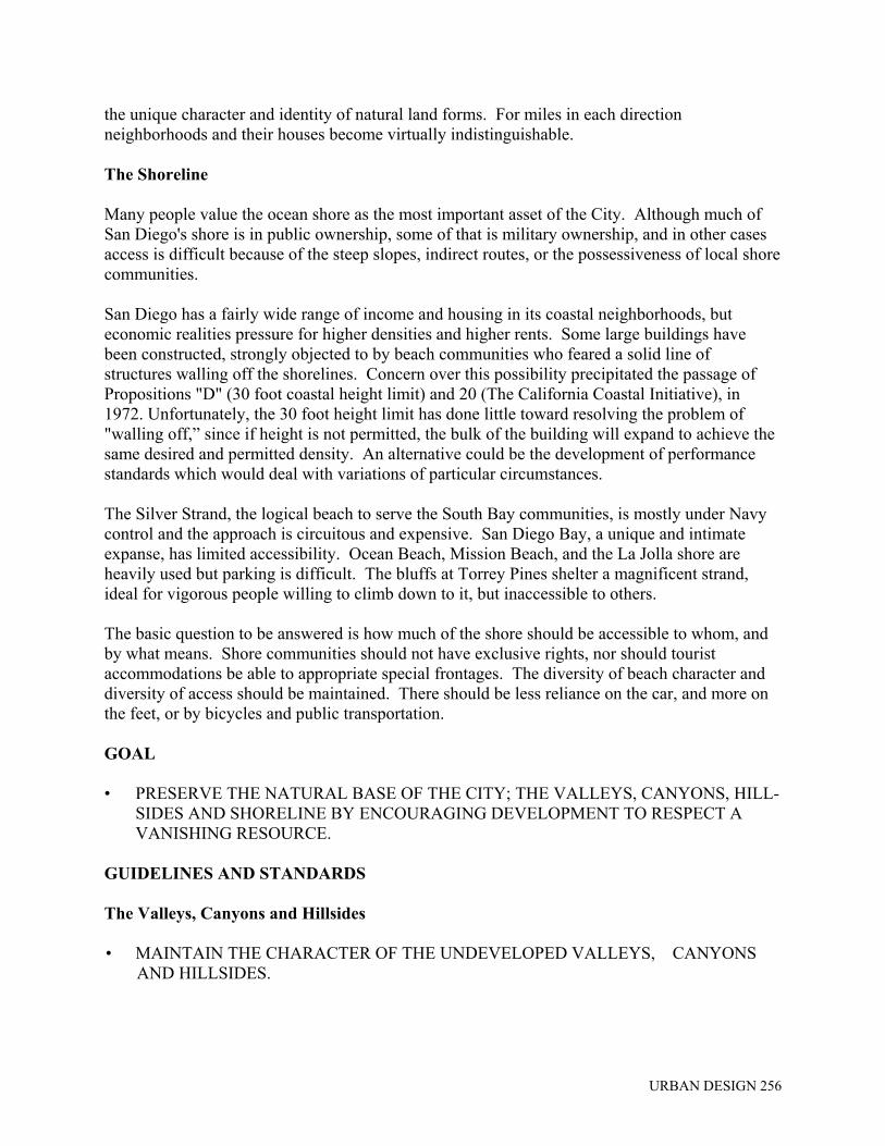
Circulation People experience their environment by traveling through it. Circulation systems set the character of cities. One aspect of transportation planning which has often been overlooked is that portion of its site planning which involves the art or form of the transportation facility. It is especially important that roadways be regarded as an integral part of the landscape in which they are sited. There must be something more than the standard provision of a surface for moving cars or guiding public transit vehicles. However, the design of the facility must not override, but be considered equally with the safety and capacity of the facility.

URBAN DESIGN 285
San Diego is an auto city that is becoming aware of the costs of a narrow transportation base. Air pollution is an immediate problem. San Diego already discharges far more than the allowable oxidant load into its atmosphere. At current rates of growth, it will continue to fall below federal standards indefinitely, unless there is an unexpected great leap forward in the technology of emissions control, or a decided shift away from the use of the car. Congestion is not yet as acute as in other cities, but the energy situation indicates the uncertainties of depending on cars. The rapid spread of the City and region is associated with the automobile, and so is the disruption of residential neighborhoods by freeways. Less dramatic is the slow deterioration of older areas and shopping centers, and the effects on personal health of the lack of exercise - not to speak of the disadvantages suffered by those who cannot drive: the old, the poor, the handicapped, the young. But it will take a massive effort to get people out of their automobiles, a two-pronged strategy of slowing the growth of auto facilities, while speeding that of other modes.
Automobile
The automobile is one of the users of space in the urban environment. It has already severed, broken and diluted many of our urban spaces. It has yielded alternative transportation methods useless. The automobile must be accepted as a means of transportation but not the only means, as it has been. We must not allow it to guide our thinking as has been so true in the past. At times it should be difficult to find parking, this prompts us to walk a few blocks when we would otherwise drive.
FINDINGS Freeways In many parts, San Diego's freeway system is magnificent. It was put in place largely prior to development, and is still not badly congested, except in certain locations and at certain times. They are masterpieces of 20th Century engineering. However, at times, it is difficult to know which freeway one is on. Gravel pits, bare hills, graded cuts not yet recovered, scar the natural landscape. Except thru Balboa Park, with its lavish use of water and its old trees, the effort to create a green setting has been unsuccessful. The adjacent urbanized land, which has its back to the freeway and yet is undergoing a rapid change due to that freeway access, is the effective visual setting, and it is nondescript. In some stretches, the freeway is flanked by telephone poles and signs. When the glare from the concrete is coupled with this open, dry landscape, the experience can be arid and eye-scorching. The freeways clearly cannot be replaced or relocated, but they need visual enhancement.

URBAN DESIGN 286
Streets We are now finding out that most of our thinking about the purpose of streets, has been one-dimensional. Officially translated into traffic policy and concrete, it has over adapted our cities to a single transportation mode, bringing on strangulation, hampering adaptability to new modes, taking flexibility and "stretch" out of our street systems. Consequently, many of the City's other purposes and systems are suffering. Obviously, streets serve a variety of purposes. One is the circulation of people, vehicles, goods and services (utilities). Streets also serve as shopping corridors, restaurant rows, linear parks, residential front yards, extensions of office lobbies, playground, ceremonial gathering places, battlefields, parade grounds, racing courses, display areas, entertainment strips, etc. For the street is really the City, organized along a corridor. It is a continuous forum for gathering where all those activities, making city life what it is, have their overture. It has economic, social, aesthetic, political, ecological, even philosophical implications - this in addition to providing a right-of-way for the circulation of people and things. Many streets in San Diego have no distinctive quality to identify due to their similar appearance. Some streets appear so "busy" with signs, billboards, utility poles and lines, and gaudy structures that they are confusing and discomforting to the observer. This condition is particularly characteristic of commercial strip development. Many major streets are inadequate in width by current standards, and have buildings set back on the basis of the present widths. Widening will bring the streets very close to these buildings, disturbing occupants with traffic noise and fumes. Widening and realignment may also destroy the visual character and identity of streets. Mature trees, other landscaping and pedestrian strips have had to be removed. Traffic generated by commercial activities fronting major streets impedes the smooth flow of through traffic. Interference with traffic movement is especially acute at intersections, where on-street parking, left turns, bus stops and numerous parking lot entrances and exits all contribute to traffic delays.

URBAN DESIGN 287
Congestion and loss of capacity are the major problems here; however, the resulting traffic chaos also looks bad. Transit The bus is the fundamental unit of a public transportation system, but people will be attracted to them, and away from cars, only if the convenience, frequency, character, and location of service is much improved. The economics of transportation costs and energy will also play an important part in the utilization of public transportation. The choice of a transit system will involve many environmental and design considerations. The size and design of the vehicles will affect the degree of privacy, awkwardness and comfort. The frequency of the stops will affect the speed of travel and ease of access, but also the number of local areas disrupted. System design can also influence the noise produced, heaviness of the structure, the ease of inserting alignments into the urban fabric. The general location of routes and stations may affect the form of regional growth. A transit system together with appropriate zoning and land use policies can induce growth just as a highway system does, therefore, the location of its routes and stations is critical for the future form of the City. Pedestrians Pedestrians in San Diego are a rarity today. It takes courage and stamina to walk. Rules, regulations, and practices governing development discourage walking as a meaningful form of transportation or recreation. The sidewalk is considered primarily as reserve space for future right-of-way expansion. If as much attention were given to sidewalks as to streets, the walker would have a chance. For instance, since cars climb more easily than people do, streets should be raised or lowered to allow level pedestrian crossings, rather than vice versa. Footways need not always hug the road system. The importance of street-front activity, trees, seats, signs, lights, and walk surfaces, must be remembered. Walking is a form of transportation which must be provided for, especially in neighborhoods for short trips to local commercial and public facilities and in business areas where many shoppers congregate. Sidewalks, malls and similar spaces provide not only for pedestrian movement but also for children's play, socializing among residents, window shopping, and sitting and watching. Congestion occurs on sidewalks in high activity areas, just as it does on streets. The inadequacy of pedestrian space creates inconveniences for those trying to pass through and those shopping or stopping to talk or look or rest. GOAL • IMPROVE THE VISUAL QUALITY AS WELL AS THE PHYSICAL EFFICIENCY OF
THE EXISTING AND FUTURE CIRCULATION SYSTEM.

URBAN DESIGN 288
GUIDELINES AND STANDARDS Freeways • FREEWAYS MUST BE SENSITIVELY DESIGNED. Beauty in freeway design is a result of the sum total of carefully planned and sensitively handled elements. Full consideration must be given to location, alignment, cross-section, scale, environmental impact, architectural detailing, and landscape development. So far as visual quality in highway design is concerned, the best solutions are "natural" solutions. These include the rolling of the highway with and around (rather than across or through) attractive topographical features. Scars resulting from road cuts should be minimized. Attractive natural elements such as hills and groves should be preserved and featured rather than destroyed. • INCORPORATE THE FREEWAY INTO THE COMMUNITY LANDSCAPE, WHERE
FEASIBLE. The existing freeway system divides the City into units of development. The improvement of the physical appearance of the freeways should be viewed as an opportunity for reinforcing these development units. Noise, fumes, and visual intrusions can be reduced by buffers and walls, but consistent sound proofing would lead to monstrous, continuous walls. Buffers must be applied with care and locally fitted. • CLUSTER PLANTS, VEGETATION, USE NATIVE PLANTS It is too expensive and water-consuming to plant the freeways continuously. Intense clumps of vegetation are more effective than slim lines of trees, or narrow bands of ice plant. Native plants or drought-resistant trees may take time to grow, but it may be possible to use irrigated planting until the native species take over. • URBAN FREEWAYS SHOULD BE PLEASANT TO DRIVE. By location and design, urban thoroughfares should be pleasant to drive. Contributing factors include an ease in finding direction, apparent directness of routing toward desired destinations, and a sense of smooth uninterrupted flow, in harmony with the landscape forms and well related to architectural features. Coloring the pavement and the guardrails in dark green, blues and browns, could do much to relieve the sense of glare and heat. Varied lighting systems, or signs which had local character and conveyed local names and information would support a sense of place in the City. U.S. highway details are presently neutral, standardized over vast areas of the state and the nation.

URBAN DESIGN 289
Streets • DESIGN STREETS FOR A LEVEL OF TRAFFIC THAT WILL NOT CAUSE A
DETRIMENTAL IMPACT ON ADJACENT LAND USES. The need for traffic carriers must be balanced against the adverse effects of heavy traffic on the use of adjacent land and the quality of the environment. The needs of residents for peace and quiet, safety from harm, and useful open space must be given consideration. Each area and each street of the City have different characteristics which determine the level of traffic to be absorbed without serious adverse impacts. The following factors should be the basis for a judgment on the acceptable levels of traffic on a specific street:
• the distance between the curb and building line established by sidewalk width or setback;
• the presence or absence of buffering between street and buildings in the form of
landscaping, change in elevation, or similar condition;
• the level of pedestrian traffic;
• the proportion of the street which is residential in land use;
• whether residences face the street;
• the presence of hospitals, schools, parks or similar facilities on or near the street. The widening of streets at the expense of sidewalks or of setbacks should not occur where space is necessary for pedestrian movement, buffering from noise, useful open space and landscaping. This is especially true in densely populated neighborhoods and commercial areas with little public or private open space. No additional sidewalk narrowings, tow-away zones and one-way streets should be instituted in residential neighborhoods. • STREET LAYOUTS WHICH DO NOT EMPHASIZE TOPOGRAPHY REDUCE THE
CLARITY OF THE CITY'S FORM AND IMAGE. Contour streets on hills which align buildings to create a pattern of strong horizontal bands that conflict with the hill form should be avoided. • THE FOLLOWING DESIGN GUIDELINES SHOULD BE USED IN THE DESIGN OF
THE STREET SYSTEM. Major Streets
• Where residential uses abut on major and secondary thoroughfares, they should be screened visually and physically wherever possible.

URBAN DESIGN 290
• A consistent pattern of trees at regular intervals should be used to identify major streets.
• Extensive buffers should be used to separate busy thoroughfares from active pedestrian areas.
• The brightness (apparent illumination) of street lighting should be greater than on
residential streets and the color or hue different from that on residential streets. The location of street lighting and transit stops must be coordinated.
• Destination information should be concentrated on major streets with signs used to
route traffic on the major streets system. Local Residential Streets
• Excessive traffic speeds and volumes should be restricted and discouraged by every means possible.
• Where possible, vehicular access directly to and from local streets should be from other
than major thoroughfares, e.g., via a secondary thoroughfare or collector street.
• When alternate access is possible, residences should not access to major thoroughfares.
• Local streets, other than collectors, should be primarily for access to residences and to serve for emergency vehicles; pedestrian-dominant streets with the maximum feasible amount of street space devoted to environmental amenities desired and needed by the residents.
• Residential streets should be well-lighted without being excessively bright.
Intersections
• Street width, traffic controls, destination and route information and illumination should be maximized at the intersection of two major thoroughfares.
• Two intersecting residential streets should have minimal roadway width, wide
sidewalks and no change in illumination from that on the streets themselves.
• Intersections of residential streets and major thoroughfares should be minimized; where they must intersect, cross and left-turn movements should be limited by curb alignments or medians.
• INCREASE THE CLARITY OF ROUTES FOR TRAVELERS. Many types of improvements can be made in street area and in their surroundings to provide greater clarity and increase the ease of travel. Once such improvements have been made, adequate maintenance of them is of equal importance.
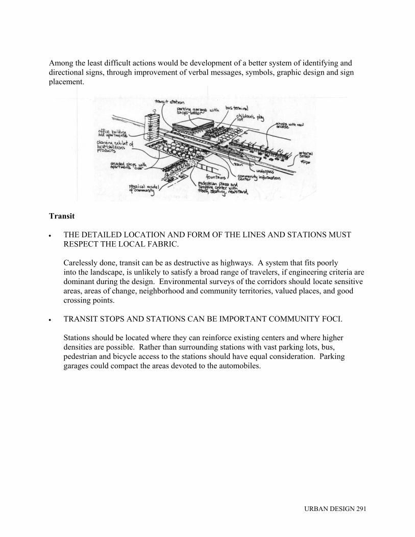
URBAN DESIGN 291
Among the least difficult actions would be development of a better system of identifying and directional signs, through improvement of verbal messages, symbols, graphic design and sign placement.
Transit • THE DETAILED LOCATION AND FORM OF THE LINES AND STATIONS MUST
RESPECT THE LOCAL FABRIC.
Carelessly done, transit can be as destructive as highways. A system that fits poorly into the landscape, is unlikely to satisfy a broad range of travelers, if engineering criteria are dominant during the design. Environmental surveys of the corridors should locate sensitive areas, areas of change, neighborhood and community territories, valued places, and good crossing points.
• TRANSIT STOPS AND STATIONS CAN BE IMPORTANT COMMUNITY FOCI.
Stations should be located where they can reinforce existing centers and where higher densities are possible. Rather than surrounding stations with vast parking lots, bus, pedestrian and bicycle access to the stations should have equal consideration. Parking garages could compact the areas devoted to the automobiles.

URBAN DESIGN 292
• TRANSIT ROUTES, STOPS, AND TRANSFER POINTS CAN BE MORE EASILY
UNDERSTOOD AND REMEMBERED IF THEY ARE DISTINCTIVELY IDENTIFIED BY SIGNS, LANDSCAPING AND ILLUMINATION.
Attractive, easily seen symbols at bus stops that indicate the type of service and the route can facilitate use of the transit system. The importance of transfer points can be expressed by the amount and type of landscaping, provision of shelters for waiting passengers, and nighttime lighting. • THE FOLLOWING DESIGN GUIDELINES SHOULD BE FOLLOWED IN THE
DESIGN OF THE TRANSIT SYSTEM.
• Major transit transfer locations should be highly visible and identifiable; wherever possible, there should be adjacent space for shelter, information, amenities and off-street loading.
• Special lighting should be used to identify transit stops.
• Lines named for streets, such as the El Cajon bus, should stay on those streets as much
as possible.
• As many routes as possible should pass through major transfer "transit locations."
• Routes should, to the extent possible, run in straight lines between well-known termini.
• Waiting areas should be extended into the parking lane and vehicle stops made in the right-hand traffic lane on major transit routes.
• Graphic symbols and color coding should be used to identify specific transit routes or
districts and places served.
• Vehicles should be distinctively marked to identify the type of service they offer: local, express, shuttle, limited-stop.

URBAN DESIGN 293
Pedestrians • WIDEN SIDEWALKS WHERE INTENSIVE COMMERCIAL, RECREATIONAL, OR
INSTITUTIONAL ACTIVITY IS PRESENT AND WHERE RESIDENTIAL DENSITIES ARE HIGH.
In many high-activity areas of the City sidewalks are narrower than required for pedestrians. Where pedestrian traffic is high and through vehicular traffic is light or can be moved to alternate routes or reduced by transit improvements, some street space can be made into wider sidewalks, landscaped strips, and sitting areas. Through traffic should be discouraged or eliminated to avoid conflicts which inconvenience drivers and pedestrians and may increase accidents. In a high density residential area with little open space, wider sidewalks and small plazas should be created to provide more usable space as well as to discourage through traffic. • ENSURE CONVENIENT AND SAFE PEDESTRIAN CROSSINGS. Where streets are designed for high volumes or relatively fast movements of vehicles, adequate provision must be made for safe and convenient pedestrian crossings. This is especially important near schools, parks and hospitals, and in high-density residential areas. Wide streets should have adequately timed lights and median strips or islands at intersections to allow safe crossings. If grade separation of pedestrian and vehicular movement is necessary, the roadway should be depressed to maintain continuity of pedestrian paths wherever possible. If a change in pedestrian levels is required, ramps are preferable to stairs. • PARTIALLY OR WHOLLY CLOSE CERTAIN STREETS NOT REQUIRED AS
TRAFFIC CARRIERS FOR PEDESTRIAN USE OR OPEN SPACE. Some streets in active shopping areas and in residential areas can be closed wholly or partially to vehicular traffic, because the streets are not required for vehicular use, except possibly at infrequent intervals or during emergencies. Partial closings can be achieved by substantially narrowing the roadway or by installing temporary barriers during certain periods of the day. Doing so would open up the street for nontraffic uses, without its loss for emergency use or access to homes and businesses.

URBAN DESIGN 294
• PROVIDE ADEQUATE LIGHT IN PUBLIC AREAS. In order to reduce the hazards of traffic at night, and provide security from crime and other dangers, public areas should have adequate lighting. Although the need for lighting is general, special attention should be given to crosswalks, bus stops and to pathways in parks and around public buildings. Care should be taken to shield the glare of any such lighting from residential properties. • DESIGN WALKWAYS AND PARKING FACILITIES TO MINIMIZE DANGER TO
PEDESTRIANS. Pedestrian walkways should be sharply delineated from traffic areas, and set apart where possible to provide a separate circulation system. Where necessary and practical, the separation should include landscaping and other barriers, and walkways should pass through the interiors of blocks. Walkways that cross streets should have pavement markings and good sight distances for motorists and pedestrians.
Driveways across sidewalks should be kept to a practical minimum, with control maintained over the number and width of curb cuts. Barriers should be installed along parking lots to avoid encroachments on sidewalks, with adequate sight distances maintained at driveways. Truck loading should occur on private property rather than in roadways or on sidewalks, and sidewalk elevators should be discouraged. Residential parking should be as close as possible to the dwellings served, with adequate lighting along the walking route from the parking to the dwellings.
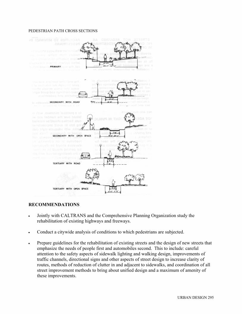
URBAN DESIGN 295
PEDESTRIAN PATH CROSS SECTIONS
RECOMMENDATIONS • Jointly with CALTRANS and the Comprehensive Planning Organization study the
rehabilitation of existing highways and freeways. • Conduct a citywide analysis of conditions to which pedestrians are subjected. • Prepare guidelines for the rehabilitation of existing streets and the design of new streets that
emphasize the needs of people first and automobiles second. This to include: careful attention to the safety aspects of sidewalk lighting and walking design, improvements of traffic channels, directional signs and other aspects of street design to increase clarity of routes, methods of reduction of clutter in and adjacent to sidewalks, and coordination of all street improvement methods to bring about unified design and a maximum of amenity of these improvements.
URBAN DESIGN 296
• Analyze along with the CPO and the MTDB proposed transit systems in order to gauge potential problems of quality, encourage good joint development, and to improve the experience of the ride and transfer. Guidelines should be laid out for the location and design of the routes, stations, and vehicles. Similar studies should be made of bus stops and routes.

URBAN DESIGN 297
GENERAL URBAN DESIGN RECOMMENDATIONS The Urban Design Element establishes a framework within which the City can preserve that which is good in the present environment, enhance that which could be better, guide or control that which is new so that it will be compatible with its surroundings both natural and built, and improve the environment where it is deficient in the qualities that are desired by the community. The Urban Design Component is a system of common reference points to enlist community agreement on courses of action with respect to urban design. It seeks to resolve the conflicts that arise from the pressures of growth and change. Just as there has been no overall plan in the past to define quality in the San Diego environment, there has been no overall implementation system, no authorized hierarchy of standards and procedures to be used in questions affecting urban design. Such a system is both difficult to establish and difficult to adapt to new pressures and changing needs. To be effective, an urban design program must employ a variety of implementing methods including regulatory provisions, capital improvement guidelines, inter-and intra-governmental procedures and public information and participation efforts. In general, an implementation program should be based on the following premises: • Effective, long-term solutions to urban design problems do not come from repeated
confrontations over development proposals. The emphasis should be upon evolving solutions by use of the best design talents, and upon the making of decisions through a rational choice among the available alternatives with all significant urban design values taken into account.
• To establish a climate for such solutions and decisions, there must be widespread agreement
on points or terms of reference before a given development project is either designed or announced. These terms of reference must be defined by public planning to which the community is committed.
• In order that such planning may have real meaning, there must be early and continuous
involvement of urban design professionals who express the public's point of view, in all significant projects affecting the physical development of the City. It is critical that this involvement be timely if it is to be effective and persuasive.
• These urban design professionals, and others who seek solutions or make decisions affecting
urban design, will be able to respond to the public's interest in a better city only if there is citizen discussion of the major issues, citywide and in each community.
The general approach just described is dependent upon processes in planning, in project review and in decision making. Taken in a very broad sense, the approach means that there must be a "planning-development process" that includes all the elements of the City affected by planning and development, both public and private. This process proceeds from the setting of overall

URBAN DESIGN 298
objectives and policies to the final execution of projects without any break in the chain of planning and decision making. The concept of such a process is extremely challenging, but it is essential to the working out of a comprehensive plan with real community significance. An effective process requires organization, which means primarily the organization of the city government to carry out its responsibilities effectively and in a responsive manner. Although organization is the business of the whole government, in matters of planning and especially urban design the City Planning Department and the City Planning Commission are cast in a central role for the making of policy and the outlining of programs to carry it out. Thorough processes and strong organization will not be fully used without community education in matters of urban design. Planning is itself an educational experience, for it helps to highlight the urban design issues and to outline the available alternatives for both the general public and their representatives in government. Among all the means of education, open meetings in the community are the most effective in encouraging a free exchange of ideas. In project review especially, but in other public and private design processes as well, it is important that key points be identified for review and consultation involving the public urban design professionals. Those professionals would in most cases be members of the staff of the City Planning Department. The input of urban design planning in these processes involves certain financial costs. It requires a commitment to a permanent urban design staff, adequate in numbers and talent to carry out its responsibilities. For effective work, and for adequate explanation of the urban design issues to other participants, especially to the public at large, the design input requires a variety of graphic illustrations, including three-dimensional models. Such illustrations are necessary to show what design alternatives are available, and to show the effects of the alternatives upon the rest of the City. On the part of private developers, who may have to provide some of this illustrative material, the urban design input may also result in additional costs in architectural services in order to improve the design of their projects. The same may be true where the projects are built with public funds. On the other hand, it is possible that the total net effect of methodical review of the urban design considerations will be a lower cost. Certainly this will be so if such review is substituted for a period of extended confrontation and redesign resulting from chaotic review and decision making. In some cases, too, the improved design solutions for either public or private projects may simply involve less expensive construction. In any event, if all public costs are considered, and the long-term effects of each project upon the City are included, any higher immediate costs that may be imposed may be regarded overall as a wise bargain. • INSTITUTE AN URBAN/ENVIRONMENTAL DESIGN PROCESS FOR THE CITY. The process will concentrate on regulatory methods, the most widely applied planning implementation technique, but also the method which has most often failed to improve environmental quality.

URBAN DESIGN 299
The Urban Design Element is intended to supplement the planning background that assists in specific application of the provisions of the planning and zoning regulations. The element is not deemed however to supersede or negate any explicitly existing provision of the planning and zoning regulations and no change can occur unless and until it is accomplished by specific legislation adopted in the manner required for ordinances. The Urban Design Element should be used as: • the basis for preparation of similar elements in community plans; • the basis for preparation of specific studies and legislation dealing with issues confronting
the built environment; • the basis for revisions to the development regulations section of the planning and zoning
regulations. The Urban Design Element and subsequent studies should be used as criteria and standards for evaluating projects requiring discretionary action; CUPs, Planned Developments, Zoning Variances and exceptions, etc. The Urban Design Element should become the basis for preparation of a council policy on design of the built environment. As part of the urban design process a method should be developed so that the planning and zoning regulations and adopted community plans can be used together to determine the appropriateness of proposed public and private development projects. • CREATE AN URBAN DESIGN SECTION WITHIN THE PLANNING DEPARTMENT. In order to begin a continuous urban design/environmental planning process the following actions should be undertaken: • Make a detailed assessment of the quality of the San Diego environment and how it is
perceived and used by its people; • Analyze how the City's environmental quality is created today, and propose strategic
changes in that process. • Propose images and policies for the future City that will stimulate public discussion and
provide a framework for the present scattered efforts to improve the quality of San Diego.
• Review and revise the zoning ordinance and other land development regulations to comply with the Urban Design Program. Prepare performance standards, development regulations, and maintenance rules to govern the private and public use of land.

URBAN DESIGN 300
Ongoing functions of the Urban Design Section would include: • Design review including evaluation of planned developments, Conditional Use Permits, and
other discretionary actions. • With other City departments and public agencies: Promote design considerations and coordinate key public projects, with private projects in redevelopment or special planning areas. • Participate in, organize, and lead special task forces formed to design and coordinate
complex public projects, or to guide the development of special districts of the City. FOOTNOTES 1. Lynch and Appleyard in their report “Temporary Paradise?" described "six basic values
which might be thought of as the environmental rights of any citizen":
Livability: An environment in which one can act with confidence, free from such dangers and discomforts as noise, pollution, accident, heat, glare, and fatigue.
Access: A region in which all groups--including, the young, the old, the poor, the handicapped, and the Spanish-speaking--have equal access to work places, education and medical facilities, recreation and open space, and to public environments of equal quality.
Sense of Place and Time: A landscape which has the definite sense of place and history of which citizens can be proud, and where the different communities take pride in their own territories.
Responsiveness: An environment in the human scale, which allows for personal control and the expression of personal values.
Pleasure and Sensibility: A landscape that is a pleasure to live in, where the senses are heightened by its richness, esthetic quality, and sense of life. Conservation: A place in which all valuable resources, both natural and urban, are cared for and conserved.
Allen B. Jacobs, former Planning Director of San Francisco, in a speech to the 1968 ASPO Convention gave the following description:
"I'm afraid that I would define social goals in fairly simplistic terms. When you put them together, they mean, to me, the Good Life! The good life is whatever each person or family or group thinks it is, or should be."

URBAN DESIGN 301
"Having said that, it does become necessary at least to try to define it. Perhaps it boils down to such simple terms and concepts as the following:"
Health: the ability to grow up and live free of environmental disorders.
Privacy: the opportunity to be alone when a person wants to be alone, with no one "bugging" him.
Comfort: physical comfort in housing and in getting around.
Fun: laughter, facilities; a place to go when a person wants to go somewhere; people around or available when one wants company, and sex. That's fun!
A chance: a chance for achievement, a chance to achieve what a person wants in terms of jobs, education, housing.
Freedom: freedom of movement, of choice, of play.
Security: physical safety; a setting in which a person may relax.
2. Time and transferable development rights are a new idea, whereby growth might be more
strictly controlled in location and timing, without giving windfall profits to some landowners and causing severe losses to others. In brief, a total maximum growth rate would be set for some region, and specific, limited zones be designated in which that growth would be al-lowed to happen. At the same time, all landowners in the region would be given marketable development rights on some equitable basis. Developers in the favored areas would have to buy up rights from other owners in order to proceed with anything more than low-density building on their land. See Lynch, "Controlling the Location and Timing of Development by the Distribution of Marketable Development Rights," unpublished, 1973.
Illustration in the Urban Design Element courtesy of: Matt Potter, "You See San Diego"S.D.A.I.A. Kevin Lynch, Donald Appleyard, "Temporary Paradise?" "Urban Design San Diego" S.D.A.I.A. National Association of Home Builders