uranium exploration in nigeria the journey so far · mika zone ne, nigeria uranium mineralisation...
TRANSCRIPT

FEDERAL REPUBLIC OF NIGERIA
The Journey so farA
November 2014
URANIUM EXPLORATION IN NIGERIA
ALEX. NWEGBU DIRECTOR GENERAL
NIGERIAN GEOLOGICAL SURVEY AGENCY (NGSA)

OUTLINE
Introduction
Historical Perspective
Geology of Nigeria
Exploration for Uranium
Current Exploration Status
Challenges
Conclusion

Introduction --Country Profile
Area: Total: 923,768 m2
Land: 910,768 m2
Water:13,000 m2
Coastline: 853 km
Capital: Abuja
Official Language: English
Major Languages: Igbo,Hausa, Yoruba.
Others include Fulani, Ijaw, Tiv, Ibibio, Kanuri,Idoma
About 250 linguistic groups
Population: 160 Million (2006)
Currency: Naira
1 USD = 156 NGN
GDP: Approx. 510 billion USD (2013)
Per – Capita Income: Approx. 2,800 USD (2013)
6.18% growth rate
Oil revenue main stay of economy

Historical Perspective
CELEBRATED 100 YEARS AS A COUNTRY IN 2014
MINERAL EXPLORATION IMPORTANT COMPONENT OF THE 100 YEAR ODYSSEY
CONDUCTED THROUGH INSTRUMENTALITY OF THE GEOLOGICAL SURVEY OF NIGERIA
TECHNICALLY SET-UP IN 1919 BY THE BRITISH TO CONDUCT RECONNAISSANCE OF MINERAL RESOURCES RATHER THAN TIME CONSUMING GEOLOGICAL MAPP
TECHNICALLY STEERED BY THE IMPERIAL INSTITUTE IN
LONDON

Early Activities of NGSA
Tar Sand at Agbabu Lignites of Asaba,
Tin & Columbite Lead/Zinc in Abakalik,
Arufui
Coal in Enugu, Udi, Kaolin
Limestones (incl. Marble)
Iron ore in Lokoja Gold in Birnin Gwari
Talc in Lapai Salt – Awe, Kukawa

Lignites of
Asaba,
Tin & Columbite
in Jos, Uwet
Tar Sand at
Agbabu
Lead/Zinc in
Abakalik, Arufui
Coal in Enugu,
Udi,
Kaolin
Limestones
(incl. Marble) in
different parts of
the country
Iron ore in Lokoja
Gold in Birnin
Gwari
Talc in Lapai
Salt – Awe,
Kukawa


Industrial Minerals known in Nigeria (Bold Letters) as at 1957;
other minerals are those required for complete industrialization

HISTORICAL PERSPECTIVE CONT.
World largest producer of Columbite
8th World producer of tin
Produced coal for railway locomotives,
Cement Manufacture and for export
Contributed substantially to GDP
Downtrend with the discovery of oil and
almost total neglect of the industry

Geological Mapping
Systematic geological mapping of selected sheets on
1:100,00 and 1:125,000
- Delineation of areas of exposure of Basement Complex & the sedimentary cover, i.e. the earliest version of the geological map of Nigeria
. The intense focus on mineral search would account for the fact that the publication of the first (even then provisional) geological map of Nigeria waited till 1943, some 23 years after the establishment of the Geological Survey of Nigeria in 1919

Provisional Geological Map of Nigeria, 1943

Geological and Mineral Map of Nigeria as at 1957

Au, Ta,U
Sn, Nb, Ta,U
Pb, Zn, Ba,U
Metallogenic (Mineral Bearing ) Provinces

Basement Complex
The migmatite-gnesis complex. The schist belts composed of metasedimentary and metavolcanic rocks. The pan-African Granitoids comprising the Older Granites and associated charnockitic rocks
Found within the
basement
complex
•Ring complexes
emplaced
during the
Jurassic
Younger Granites
Tertiary-Recent
Volcanic rocks.
Volcanic rocks

Geology of Nigeria
Sedimentary Series in 7 basins
• Niger Delta, Dahomey, Anambra,
Bida, Benue related to the opening of
the Gulf of the Guinea.
• Sokoto and Chad basins are part of
larger basins outside Nigeria.

Schists • From North-
West to South West
• Associated with Au, Nb-Ta wolframite and Gemstone mineralisation
Granitic Rocks
North-west, North-Central, South-West, zones and South-Eastern to North –Eastern axis
• Sn, Ta, W
• Gemstone
Old Sedimentary rocks
• Benue Valley South Eastern, North Central and North-Eastern Flank
• Associated with Pb, Zn, Ag, Co, Ba, Cu

Radiometric Anomalies (1974-76 Data)
1974-1976 airborne
survey at 2km spacing
These areas covered by
the survey include:
The lower Benue and the
adjoining regions.
Ugep – Cross River State
Niger/Benue Confluence
(Kogi State)
Sokoto and Dange areas


Govt. Initiative on Uranium exploration
NORTHWEST-Ririwai Younger Granite ring Complex Major known prospect appears to lie in the Ririwai Younger Granites hosting reportedly the largest deposit of uraniferous pyroclore, an ore of niobium with small amounts of U & Th
i. Peralumunous Granite
ii Peralkaline (Pyrochlore)
NORTHEAST-
i Mika (Uraniferous rhyolites emplaced in Pan Africa Granites
ii Gumchi (Sheared porphyric Granite
iii Mayo Lope (Bima sandstone)
SOUTHEAST- i Ugep-Idomi in Cross River state
ii Udi in Enugu state
NORTH WEST- Sokoto Phosphate Exploration

URANIUM EXPLORATION INTENSIFIED
To further the process of Uranium exploration
the Fed. Govt. of Nigeria formed the;
Nigerian Uranium Mining corporation in
Technical Partnership with TOTAL COMPAGNIE
MINIERE (TCM) of France
Primarily to explore, develop and mine uranium
deposits in Nigeria

NUMCO Operations
NUMCO’S Choice of location was based on;
i PanAfrican granitic and metamorphic basement
ii Young granites and volcanic complexes
iii Sedimentary cover with Niger type targets
Operated on an area 112,346 sq km
(Lat. 11* 30’N-8* N and Long. 10* 30’E to the Cameroun boarder)

NUMCO EXPLORATION INITIATIVE
MIKA
GUMCHI
VLF survey 65 nos. drill holes 6,348 metres 100 t U at grade of 0.9 % up to 200 m at cut off of 0.03% 5,679 m logged
MAYO LOPE
Stratiform occurrences at 200-350m depth Hydrogeochemical survey 3 nos. holes drilled (257.86m)
14,173 line km of Heliborne gama-ray
spec. survey Mineralization at granite shear zone 23 nos. 434.8 m of drill cores 52 t U at 0.63% at 130m cut off of 0.03%


Uranium Exploration-N.E. Nigeria
Promising areas include Kaltungo Gubrunde, Ghumshi, Mika and Mayolope.
Garkida (Mubi Area)
Mika (South Benue Area)
Kaltungo
Gubrunde

S/
N Proje
ct
locati
on
Geology Quant
ity
Average
grade
ppm
UNFC
-2009
Class
UNFC
-2009
Subcl
ass
E F G Remarks
1. Mika
zone
NE,
Nigeria
Uranium
mineralisation in
Rhyolite
130tU 540ppm Expl.
projec
t
3 3 3 More
drilling
needed
2. Ririwai
NW,
Nigeria
Uranium bearing
mineral is
pyrochlore in
Peralkaline
Granite
215ppm Expl.
projec
t
3 3 4 More
drilling
needed
3. Ghumc
hi
Uranium in
Brecciated,
Silicified and
Mylonitized rocks
Hosting U
Anomalies
porphyric
granites,
2000pp
m
3 3 4 More
drilling
needed
4. Mayo
lope
sycline
Uranium in
Cretaceous Bima
Sandstone
1826pp
m
3 3 4 More
drilling
needed

AIRBORNE GEOPHYSICAL COVERAGE

Areas with concentration greater than 5 ppm.
Red patches indicate
high uranium anomaly
whereas, green
shading indicates
medium uranium
anomaly. You could
observe from the map
that uranium also occur
within the sedimentary
Basins - especially the
Lower Benue Trough
and larger part of the
Bida Basin

Uranium Concentration map of Bida
basin
Areas with pink
colour in the
central and
southern parts
are anomalous
zone for
Uranium
mineralisation.

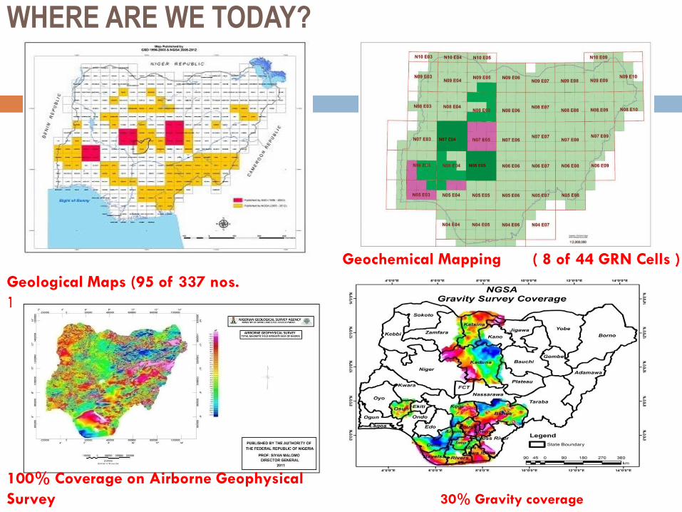
WHERE ARE WE TODAY?
30% Gravity coverage
Geological Maps (95 of 337 nos.
1:100,000
Geochemical Mapping ( 8 of 44 GRN Cells )
100% Coverage on Airborne Geophysical
Survey

Survey Outputs: Types of Geoscience Data used by Industry
31
Geological Maps Geochemistry map (Gold – Koton Karfi Cel)
Geophysical Map (Nigeria)

Where are we today?
Airborne EM coverage (24,000Km) Lineament Map

Moving Forward
NGSA will continue more systematic exploration taking advantage of new air borne data
Continuation of our National geochemical mapping programme
More comprehensive analysis of the Coal and Phosphate resources
Re-analyzing the cores from the NUMCO uranium exploration projects
Studying the oil company cores/logs
Ensuring easy access to geoscience data for interested investors

CHALLENGES TO UNCF
IMPLEMENTATION
Limited access to credible data from private companies
operating in the solid minerals and the petroleum sector
Time frame required to educate all stakeholders on the
need to adopt the UNFC-2009
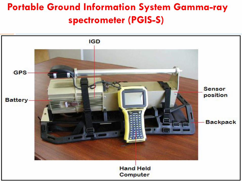
Portable Ground Information System Gamma-ray
spectrometer (PGIS-S)

SURVEY TECHNIQUES
THANK YOU www.ngsa-nig.org