updating a medium-scale landslide database for...
TRANSCRIPT

1
Add: 67 Chien Thang Street, Ha Dong District,
Hanoi City, Vietnam
Phone : (++84) 4 3854 4386
Fax: (++84) 4 3854 2125
Email: [email protected]
Website: http://www.vigmr.vn
On-going program of the State-Funded Landslide Project (SFLP):
Updating a medium-scale landslide database for
high-risk areas using community surveys in Vietnam
Coordinated by: Le Quoc Hung, Pham Van Son, Nguyen Thi Hai Van et al.

CONTENTS
I. Introduction - Master Project (SFLP)
II. Aims and main tasks of on-going project
III. Pilot surveys and initial results
IV.Challenges

I. INTRODUCTION
State-Funded Lanslide Project (SFLP)
Full title: Investigation, assessment and warning zonation for
landslides in the mountainous regions of Vietnam
❖ Carrying out by:
➢ ~500 staffs of 15 organizations in Vietnam)
➢ Leading agency : Vietnam Institute of Geosciences and Mineral Resources (VIGMR)
❖ Implemented in mountainous areas
➢ 75% area of the country mainland
➢ 37/63 provinces
❖ Goals:
➢ Establishment of a standard national database on landslides and generation of landslide
hazard maps at 1:50,000 for 37 mountainous provinces of Vietnam, and at 1:10,000 for hot-
spot areas
➢ Design of an Early Warning System for landslides, and implementing that in a number of
test areas

1. A national database and WebGIS on landslides and related
factors;
2. Landslide warning zonation maps at 1:50,000 scales for 37
mountainous provinces, and at 1:10,000 scales for hotspots
areas:
➢ Landslide inventory maps
➢ Landslide susceptibility maps
➢ Landslide hazard maps
➢ Landslide risk maps
3. A pilot network of landslide monitoring stations
4. Reports and guidelines to end-users for:
➢ Using the result maps, WebGIS and database
➢ Recommendation of landslide mitigation measures;
➢ Dissemination and communication of landslide preparedness, prevention and
mitigation;
➢ Proposed network of landslide monitoring and early warning for very high
landslide hazard areas.
SFLP: Main outputs

SFLP: Workflow
(adapted from Castellanos Abella, E.A., de Jong, S.M., Van Westen, C.J. and van Asch, W.J., 2008. Multi-scale landslide risk assessment in Cuba. ITC,
University of Utrecht. ITC Dissertation 154, 272 p. ISBN: 978-90-6164-268- 8)
A: Data collection and factor mapping
B: Susceptibility and hazard assessment
C: Vulnerability assessment
D: Risk assessment

SFLP: Results so far
Nr. Provinces Inventory Maps
Susceptibility Maps
Hazard, Vunerability and
Risk Maps
1 Lai Chau 2013 2016 -
2 Dien Bien 2013 2016 -
3 Son La 2013 2016-2017 -
4 Lao Cai 2013 2014 -
5 Yen Bai 2013 2014 -
6 Ha Giang 2013 2017 -
7 Tuyen Quang 2013 2018 -
8 Cao Bang 2014 2017 -
9 Bac Kan 2013 2017 -
10 Bac Giang 2014 2018 -
11 Quang Ninh 2014 2018 -
12 Hoa Binh 2014 2018 -
13 Thanh Hoa 2012 2014 -
14 Nghe An 2012 2014 -
15 Lang Son 2016 2018 -
16 Ha Tinh 2017 - -
17 Quang Binh 2017 - -
18 Quang Tri 2018 - -
19-37 19 other provinces
- - -
Results maps at 1:50,000 scale:

PROJECT RESULT SO FAR
(10/2012-12/2015)Landslide inventory maps at 1:50,000 scales for 17 Northern mountainous provinces that are compiled
for publication

PROJECT RESULT SO FAR
(10/2012-12/2017)Landslide susceptibility maps at 1:50,000 scales for 10 Northern mountainous provinces: Nghe An,
Thanh Hoa, Lao Cai, Yen Bai, Lai Chau, Dien Bien, Son La, Ha Giang, Cao Bang, Bac Kan

1. Those maps were not regularly to be updated
➔ the environmental factors have kept changing
➔ landslides have still occurred
➔ previously-produced maps much different from present situation
2. For many high-risk areas, the authorities demand the risk maps at larger
scales
➔ very difficult to construct due to the lack of necessary input data.
3. It is required to implement a program to update the landslide database for
selected high-risk areas.
SFLP: Urgent needs
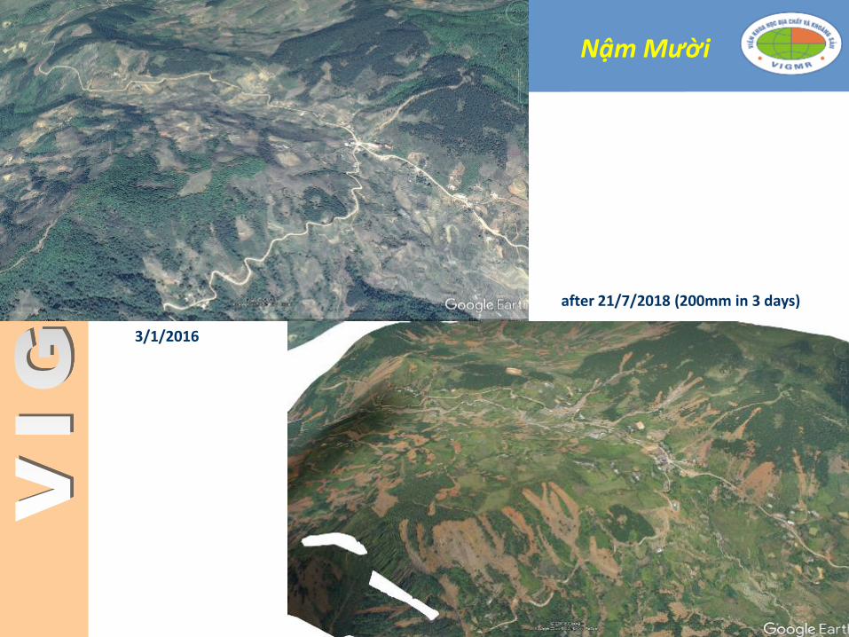
Nậm Mười
3/1/2016
after 21/7/2018 (200mm in 3 days)
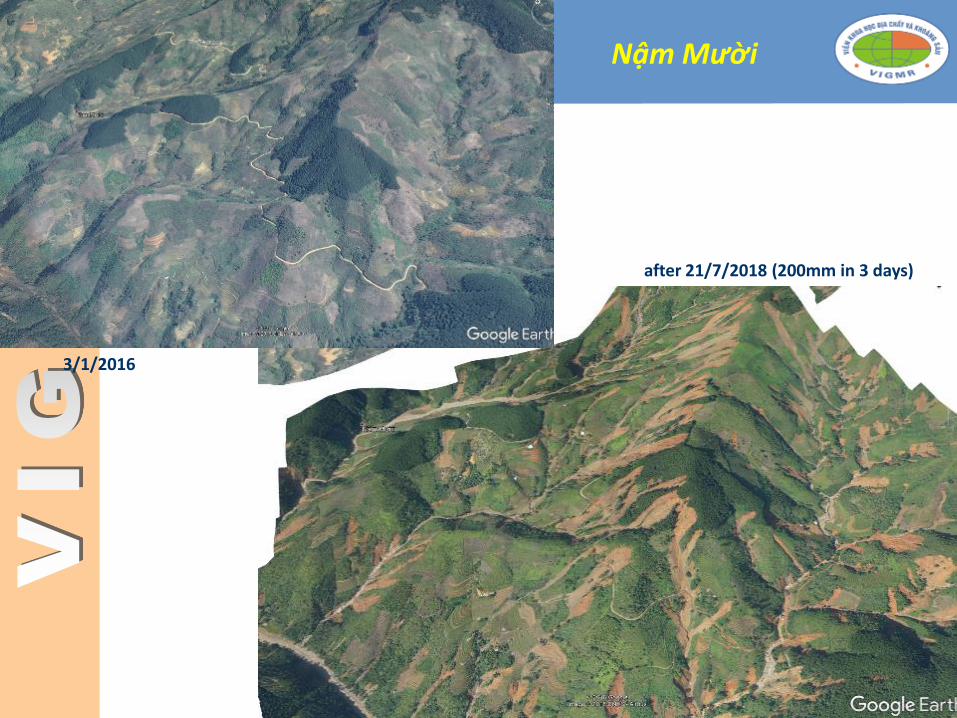
3/1/2016
Nậm Mười
after 21/7/2018 (200mm in 3 days)

II. ONGOING PROJECT
Full title: Updating a medium-scale landslide database for
high-risk areas using community surveys in Vietnam
❖ Study areas:
➢ Selected 220 high risk communes in 10 Northern mountainous provinces
(20,000 km2)
❖ Goals:
➢ Investigating and updating the landslide database for the 220 selected high-
risk communes in landslide-prone areas in Northern mountainous
provinces using community surveys
➢ Mapping the landslide risk areas at 1: 10,000 scale and disseminating the
result maps to the local authorities and people with community guidance

II. ONGOING PROJECT
Deliverables
➢ An up-to-date spatial landslide database for high-risk
communes;
➢ A set of landslide inventory, susceptibility and risk maps
at 1:10.000 scale;
➢ Guidelines for dissemination and communication of
landslide preparedness, prevention and mitigation for
local authorities and people

II. ONGOING PROJECT
Main approaches
➢ Community surveys
➢ Geological surveys
➢ Image interpretation

COMMUNIIY AND GEOLOGICAL SURVEYS
Field work...
Field note...
Landslide
description sheet
Landslide inventory Database
GIS and Mapping
Soil description
sheet

IMAGE INTERPRETATION
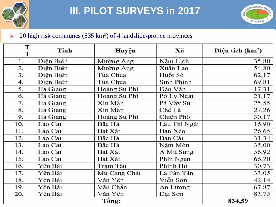
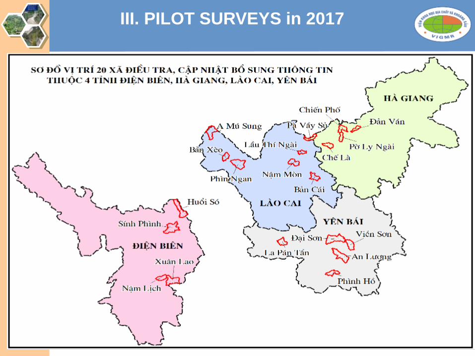
III. PILOT SURVEYS in 2017
➢ 20 high risk communes (835 km2) of 4 landslide-pronce provinces
III. PILOT SURVEYS in 2017

III. INITIAL RESULTS:
Updated database inventory mappingXã Previous database Updated
database
Updated unstable
slopes
Interviews
Nặm Lịch 8 37 14 25
Xuân Lao 1 25 8 38
Huổi Só 0 40 21 9
Sính Phình 20 101 48 29
Lầu Thí Ngài
8 43 6 13
Bản Cái 2 9 13 11
Nậm Mòn 3 31 16 17
Bản Xèo 7 51 21 9
A Mú Sung 10 63 11 5
Phìn Ngan 10 77 22 5
Đản Ván 1 32 32 12
Pờ Ly Ngài 1 50 22 17
Chiến Phố 15 131 60 9
Pà Vầy Sủ 0 59 15 7
Chế Là 2 31 23 26
Phình Hồ 5 48 11 9
La Pán Tẩn 15 114 29 13
An Lương 7 18 17 17
Đại Sơn 24 57 18 33
Viễn Sơn 13 47 19 36
TỔNG 152 1064 426 340

III. INITIAL RESULTS:
Updated database: susceptibility mappingTT Communes Area
(km2)Very high
(km2)
High (km2)
Moderate (km2)
Low Very low
(km2)
Very high (%)
High (%)
Moderate (%)
Low (%)
Very low (%)
1 Nặm Lịch 36 5.20 15.81 14.79 0.88 0.17 14.11 42.92 40.14 2.38 0.45
2 Xuân Lao 59.7955 8.21 28.85 19.82 1.48 1.39 22.29 78.31 53.78 4.03 3.78
3 Huổi Só 62.1712 6.09 12.23 30.19 10.52 4.32 16.54 33.20 81.93 28.55 11.74
4 Sính Phình 70.0634 20.85 20.10 23.82 5.22 0.33 56.58 54.56 64.64 14.17 0.88
5 Lầu Thí Ngài 16.9 4.58 4.06 5.59 2.32 0.32 12.44 11.01 15.16 6.29 0.86
6 Bản Cái 31 4.61 19.43 7.79 0.07 12.50 52.74 21.13 0.18
7 Nậm Mòn 35 6.96 14.70 8.38 4.63 0.19 18.89 39.90 22.73 12.55 0.50
8 Bản Xèo 26.5288 7.97 6.98 7.71 3.90 21.64 18.93 20.94 10.58
9 A Mú Sung 57 14.80 26.18 13.67 1.80 0.11 40.16 71.06 37.10 4.89 0.31
10 Phìn Ngan 66 30.63 23.25 6.97 4.18 0.88 83.14 63.09 18.92 11.35 2.39
11 Đản Ván 17 6.37 8.33 2.53 17.29 22.62 6.87
12 Pờ Ly Ngài 21.6223 7.54 8.79 4.82 20.48 23.85 13.09
13 Chiến Phố 30.31 18.83 9.20 2.28 51.11 24.96 6.19
14 Pà Vầy Sủ 25.55 9.84 13.82 1.47 0.08 26.70 37.50 3.98 0.21
15 Chế Là 26.34 6.07 15.00 5.04 0.23 16.47 40.70 13.67 0.62
16 Phình Hồ 31 6.30 12.66 11.64 17.09 34.35 31.59
17 La Pán Tẩn 33.2726 15.63 11.03 6.33 42.43 29.93 17.19
18 An Lương 68.51 6.50 16.17 42.52 1.45 1.45 17.63 43.88 115.41 3.93 3.94
19 Đại Sơn 81.15 6.55 28.82 41.55 3.96 3.07 17.78 78.22 112.77 10.75 8.34
20 Viễn Sơn 42.5116 7.21 12.72 20.92 1.18 0.25 19.56 34.53 56.79 3.21 0.69
TỔNG 837.7254 200.74 308.13 277.82 41.90 12.48 544.82 836.27 754.01 113.71 33.88

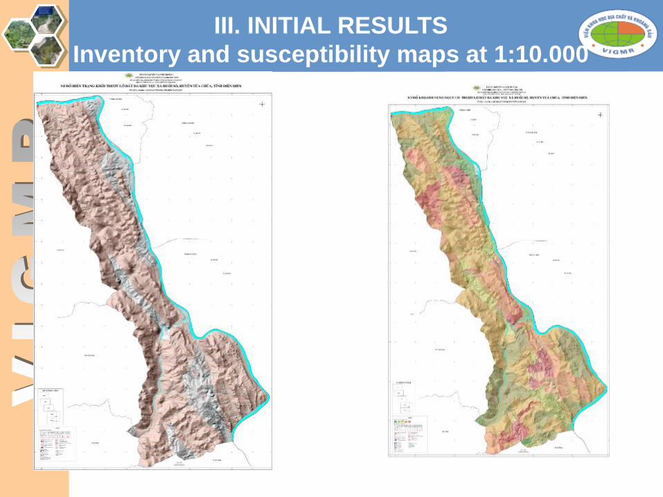
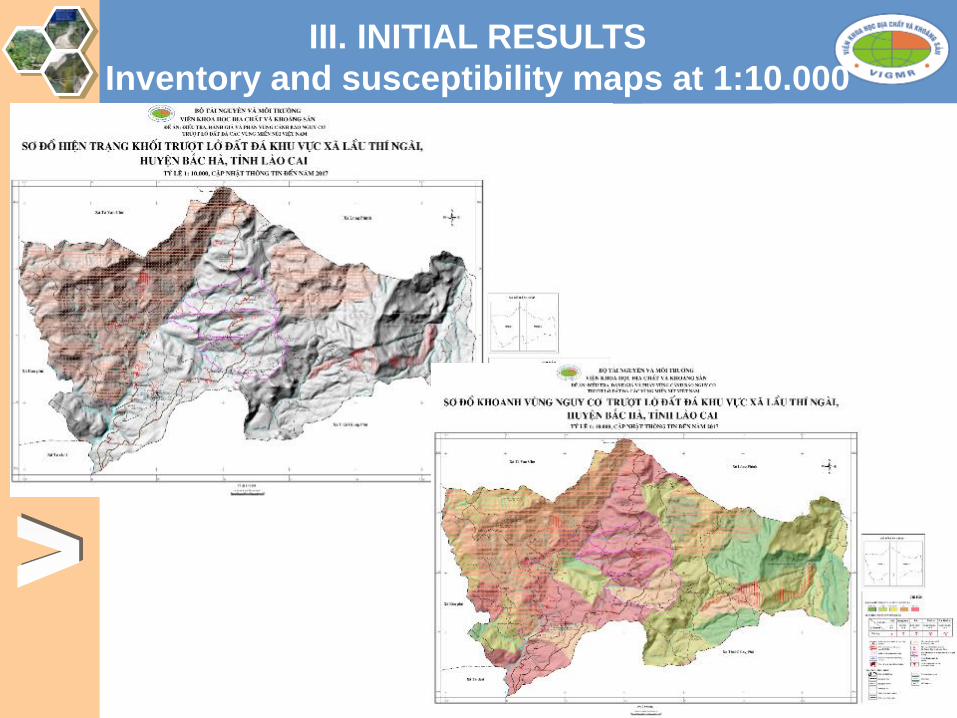
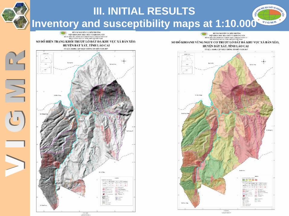
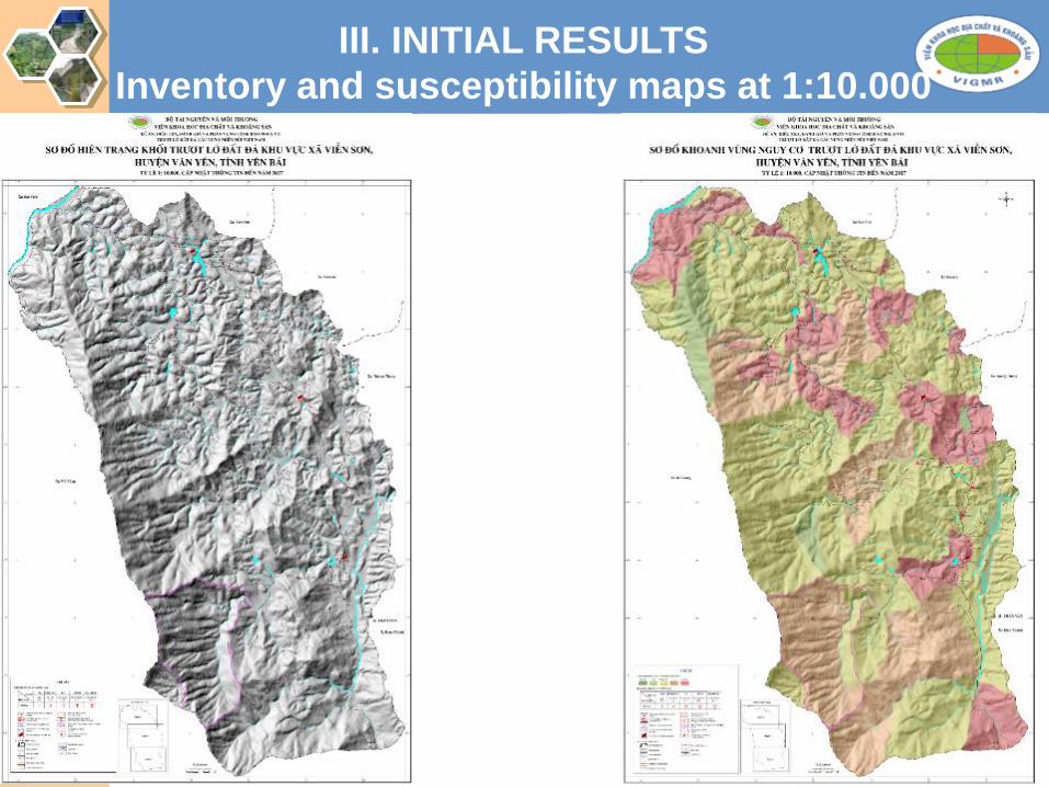
III. INITIAL RESULTS
Inventory and susceptibility maps at 1:10.000
scale

III. INITIAL RESULTS
Inventory and susceptibility maps at 1:10.000
scale

III. INITIAL RESULTS
Inventory and susceptibility maps at 1:10.000
scale
III. INITIAL RESULTS
Inventory and susceptibility maps at 1:10.000
scale
III. INITIAL RESULTS
Inventory and susceptibility maps at 1:10.000
scale

III. INITIAL RESULTS
Inventory and susceptibility maps at 1:10.000
scale

III. INITIAL RESULTS
Inventory and susceptibility maps at 1:10.000
scale

III. INITIAL RESULTS
Inventory and susceptibility maps at 1:10.000
scale

III. INITIAL RESULTS
Inventory and susceptibility maps at 1:10.000
scale
III. INITIAL RESULTS
Inventory and susceptibility maps at 1:10.000
scale

III. INITIAL RESULTS
Inventory and susceptibility maps at 1:10.000
scale

III. INITIAL RESULTS
Inventory and susceptibility maps at 1:10.000
scale

III. INITIAL RESULTS
Inventory and susceptibility maps at 1:10.000
scale

III. INITIAL RESULTS
Inventory and susceptibility maps at 1:10.000
scale

III. INITIAL RESULTS
Inventory and susceptibility maps at 1:10.000
scale

III. INITIAL RESULTS
Inventory and susceptibility maps at 1:10.000
scale

III. INITIAL RESULTS
Inventory and susceptibility maps at 1:10.000
scale

III. INITIAL RESULTS
Inventory and susceptibility maps at 1:10.000
scale

III. INITIAL RESULTS
Inventory and susceptibility maps at 1:10.000
scale
III. INITIAL RESULTS
Inventory and susceptibility maps at 1:10.000
scale

IV. CHALLENGES AND NEXT PLANS
❖Updating the landslide database to propose the areas
for temporal evacuation and for permament relocation
❖Collaboration with local government for:
➢ Community education using Project resutls and deliverables;
➢ Updating landslide inventory database from communities
through email, WebGIS, facebook, SMS, etc.);
➢ Setup of a pilot landslide monitoring system.
❖Collaboration with international experts for improve
the survey technologies

Looking forwards to hearing your
comments to improve our work!