up 2008 12.09 1 coune - mit opencourseware | free … · centered near the town of cape charles,...
TRANSCRIPT

UP 2008 12.09 1 Special Topicm Coune January 8 - 22,3008
Mamwhumettm Inmtitute of Technology

1. Introduction to Terrestrial Impact Cratering
2. Review of Some Major Research Studies of Terrestrial Impact Craters
3. Tools of Analysis4. Impact Crater: Chesapeake Bay
Well Logging and Geochemical Studies
5. Impact Cratering: Economic Potential and Environmental Effects
6. Conclusion2
January 17, 2008: IAP
2008 12.091 SE
SS
ION
4: P.ILA

The course work involves the following:January 8, 10, 15, 17, 22 10 AM to Noon5 sessions each of 2 hours - 25%Study/work assignments – 4 - 20%ProjectLiterature Survey &Writing a report - 30%
Project Presentation - 25%Required percentage to pass this course is 95%Grading: P/F
3
January 17, 2008: IAP
2008 12.091 SE
SS
ION
4: P.ILA

4
January 17, 2008: IAP
2008 12.091 SE
SS
ION
4: P.ILA

Chesapeake Bay Impact Structure
Hydrogeological study:Geophysical Well Logging InvestigationGeochemical Study:
North American Tektite Investigation
5
January 17, 2008: IAP
2008 12.091 SE
SS
ION
4: P.ILA

Chesapeake Bay Impact CraterVirginia, USA
Latitude N 37° 17'Longitude W 76° 1'Diameter 90.00 kmAge 35.5 ± 0.3 Ma
Regional map of Chesapeake Bay Impact Crater can be seen in the USGS Open File Report 2007-1094.
6
January 17, 2008: IAP
2008 12.091 SE
SS
ION
4: P.ILA

CHESAPEAKE BAY IMPACT STRUCTURE
Chesapeake Bay impact structure formed ● about 35 million years ago,● during the late Eocene period,● a comet fragment or asteroid struck the
U.S. Atlantic continental shelf ● currently the area is the southern part of
Chesapeake Bay & adjacent land masses in the Virginia Coastal Plain.
The impact structure ● approximately circular,
● 53-mile-diameter crater,● centered near the town of Cape Charles,
Va.Materials within the structure currently exist beneath hundreds of feet of younger Cenozoic marine sediments.(65 Ma to Present) 7
January 17, 2008: IAP
2008 12.091 SE
SS
ION
4: P.ILA

The scientific community has been studying Chesapeake Bay impact crater, impact event and its effects
Early 1980s - Glomar Challenger deep-sea cores containing the crater’s ejecta off Atlantic City, New Jersey.
8
January 17, 2008: IAP
2008 12.091 SE
SS
ION
4: P.ILA

Information about the Chesapeake Bay impact structure is available in numerous published studies such as:Koeberl and others (1996), Poag (1997),Powars and Bruce (1999), Powars (2000), Edwards et al (2004), Poag et al (2004),Horton and others(2005),Gohn et al (2007).
9
January 17, 2008: IAP
2008 12.091 SE
SS
ION
4: P.ILA
The purpose of the discussion is to understand what is involved in geophysical well logging andand its use in the hydrogeologic study.
The following discussion is based on the USGS Report byG. S. Gohn, W. E. Sanford, D. S. Powars, J. W. Horton,
Jr., L. E. Edwards, R. H. Morin, and J. M. Self-Trail,Site report for USGS test holes drilled at CapeCharles, Northampton County, Virginia, in 2004 USGS Open-File Report 2007–1094.
10
January 17, 2008: IAP
2008 12.091 SE
SS
ION
4: P.ILA

The Chesapeake Bay impact structure spatially coincides with a well used inland zone of salty ground water. This spatial association strongly suggests a genetic association(Powars and Bruce, 1999; McFarland and Bruce, 2005). The presence of the inland salt-water zone has practical significant effect on the increasing demand on fresh water supply by the rapid population and commercial growth in areas above and near to the salt-water zone. (Emry and Miller, 2004). Detailed knowledge of the distribution of the salt-water zone and its formative processes are important to determine whether increased ground-water pumping in adjacent areas will lead to migration of the salt water. [Horton and others (2005a, b)]
11
January 17, 2008: IAP
2008 12.091 SE
SS
ION
4: P.ILA
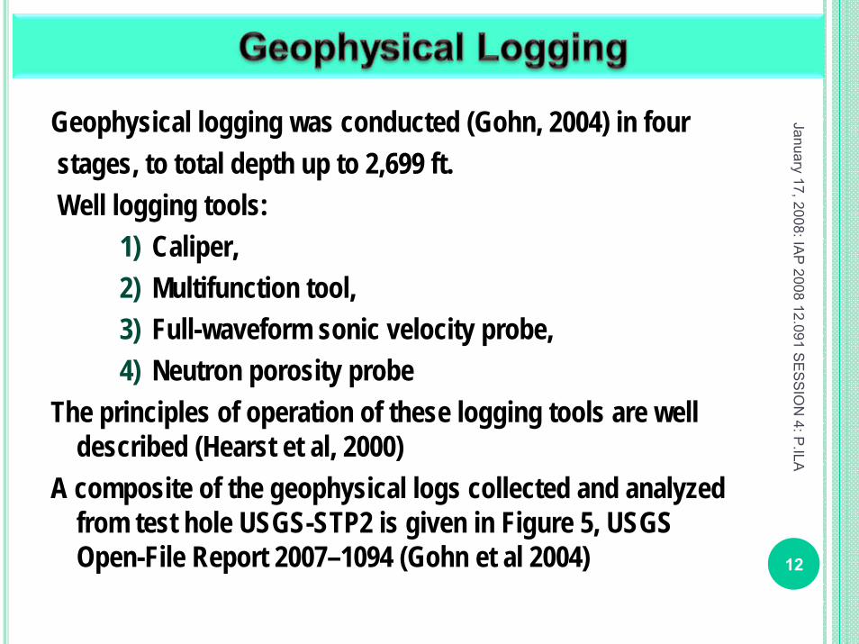
Geophysical logging was conducted (Gohn, 2004) in fourstages, to total depth up to 2,699 ft. Well logging tools:
1) Caliper,2) Multifunction tool, 3) Full-waveform sonic velocity probe, 4) Neutron porosity probe
The principles of operation of these logging tools are well described (Hearst et al, 2000)
A composite of the geophysical logs collected and analyzed from test hole USGS-STP2 is given in Figure 5, USGS Open-File Report 2007–1094 (Gohn et al 2004) 12
January 17, 2008: IAP
2008 12.091 SE
SS
ION
4: P.ILA

The caliper log provides information about uniformity of the bore hole
the mechanical strength of the bore hole materials.
Log displays significant enlargements in borehole diameter within the postimpactsediments and the sediment-clast breccia that extend well beyond bit gauge. Significant variation in the sediment (borehole) diameter is indicative of a very unstable and mechanically weak geologic materials. Improvement of the conditions are seen markedly below 2,150 ft in the more competent breccia-gneiss section, and the replacement of the drilling bit with the coring bit near 2,440 ft is recognized as a step reduction in diameter at 2,444 ft.
13
January 17, 2008: IAP
2008 12.091 SE
SS
ION
4: P.ILA
1) Measurement of borehole diameter by caliper

January 17, 2008: IAP
2008 12.091 SE
SS
ION
4: P.ILA
14
Figure shows Depth vs. Borehole diameter
variationenlargements in borehole diameter within
1) the post-impact sediments 2) the sediment-clast breccia
indicating very unstable boreholemechanically weak geologic
materials.
below 2,150 ft breccia-gneiss section,
near 2,440 ft is recognized as a step reduction in diameter
1) Measurement of borehole diameter by caliper …
Figure based on "Composite of geophysical logs obtained in test hole USGS-STP2", Gohnet al 2004.

Multifunction tool measuresnatural gamma activity, electrical resistivity, borehole fluid conductivity, borehole fluid temperature.
Sometimes borehole fluid conductivity and temperature data may not be useful under the field conditions because of the significant disturbances by drilling. 15
January 17, 2008: IAP
2008 12.091 SE
SS
ION
4: P.ILA
2) The multifunction tool measurement

January 17, 2008: IAP
2008 12.091 SE
SS
ION
4: P.ILA
16
The gamma-activity log is a measure of natural gamma radiation being emitted by the surrounding rocks and sediments.
Clays accumulate radioisotopes through adsorption and ion-exchange processes, high gamma activity are indicative of clay rich zones.
Feldspathic sandstones, phosphatic limestones, and glauconitic sands also are associated with high gamma responses.
Two zones that displayed increased gamma counts lower part of the postimpact sediments (940 ft to 1,150 ft) upper part of the breccia-gneiss section (2,150 ft to 2,220 ft).
2) The multifunction tool – gamma activity measurement

17
January 17, 2008: IAP
2008 12.091 SE
SS
ION
4: P.ILA
Figure based on Figure 7, Gohn et al 2004.

Resistivity profiles are effective in identifying freshwater-seawater interfaces.
Electrical resistivity measurements consist of short-normal (16-inch) and long normal (64-inch) resistivities, also referred to as near and far resistivities, respectively.
Saturated formation resistivity is primarily a function of porosity, pore-fluid resistivity, and mineralogy, typically correlating positively with grain size and negatively with porosity.
A lower resistivity corresponds to higher porosity or to smaller grain size. The understanding is that surface area associated with fine particles promotes the transmission of electric current (Biella and others, 1983; Kwader, 1985). 18
January 17, 2008: IAP
2008 12.091 SE
SS
ION
4: P.ILA
2) The multifunction tool – electrical resistivity measurement

19
January 17, 2008: IAP
2008 12.091 SE
SS
ION
4: P.ILA
Figure based on “Composite of geophysical logs obtained in test hole USGS-STP2”, Gohn et al 2004.

The full-waveform sonic tool is equipped with a variable frequency transmitter and three receivers.
The measurements consist of :Gathering the logs at a frequency of 10 kHz.Processing them by means of a semblance technique (Pailletand Cheng, 1991) to estimate sonic velocities. Plotting of compressional - wave velocity VP (solid line) vs. shear-wave velocity VS (dashed line) It is difficult to have sufficient energy transmission into thesurrounding rocks to generate a detectable shear wave in all
but the hardest rocks. Thus, the plot of VS gets limited to only the lower most breccia-gneiss section, where VS is roughly half the velocity of VP. These values fall within a well-constrained lithology band presented by Paillet and Cheng (1991).
20
January 17, 2008: IAP
2008 12.091 SE
SS
ION
4: P.ILA
3. Full-waveform sonic velocity measurement

January 17, 2008: IAP
2008 12.091 SE
SS
ION
4: P.ILA
21
Figure shows log of the compressional-wave velocity
vs. depth to 2,440 ft.The log is clearly identifying the delineation and the contact between the postimpact sedimentsThe log is indicating that the value ofVP in the sediments approaches thatof water alone (~ 1.55 km/s), underlying sediment-clast brecciaat 1,163 ft.
Below this contact, the compressional-wave velocities gradually increase downward in the sediment-clast breccia. Below 2,150 ft, VP increases to almost 5 km/s as the rocks become more indurated and mechanically competent, due to poor sampling conditions (borehole enlargements, mud invasion)
3. Full-waveform sonic velocity measurement …
Figure based on "Composite of geophysical logs obtained in test hole USGS-STP2", Gohn et al 2004.

The neutron probe estimates saturated formation porosity.Specially designed test pits are used to calibrate the neutron detector . The response of the neutron detector, in counts per second, can be accurately converted to quantitative values of total porosity. The formation should be saturated. This estimate of total porosity includes both free water and bound water on clay surfaces.
22
January 17, 2008: IAP
2008 12.091 SE
SS
ION
4: P.ILA
4) Neutron porosity measurement

January 17, 2008: IAP
2008 12.091 SE
SS
ION
4: P.ILA
23
The figure shows Porosity vs. Depth
The porosity log shows a marked shift at the sediment-brecciacontact (1,163 ft) The log clearly distinguishes between the high-porosity postimpact marine sediments (porosity ~ 60 percent) and the underlying sediment-clast breccia(porosity ~ 20 percent). The porosity estimates for the postimpact sediments are in the range of roughly 50 to 65 percent,
Figure based on "Composite of geophysical logs obtained in test hole USGS-STP2", Gohn et al 2004.
4) Neutron porosity measurement

(Powars and Bruce, 1999; Powars, 2000; Gohn et al 2007):Marine, glauconitic, shelly sands of late Paleoceneage compose the Aquia aquifer, which is regionallyextensive but only a minor ground-water supplyresource. Generally similar, but finer-grained sediments of late Paleocene to early Eocene age compose the overlying Nanjemoy-Marlboro confining unit. Both hydrogeologic units are truncated along the margin of the Chesapeake Bay impact crater. 24
January 17, 2008: IAP
2008 12.091 SE
SS
ION
4: P.ILA

(Powars and Bruce, 1999; Powars, 2000; Gohn et al 2007):
“Sediments of late Eocene age compose three newlydesignated confining units that overlie the Potomacaquifer within the Chesapeake Bay impact crater.These confining units include, from bottom to top, theimpact-generated, lithologically distinctive but highlyvariable Exmore clast and Exmore matrix confiningunits and the marine, clayey Chickahominy confiningunit. The three confining units collectively impedeground-water flow across the crater.”
25
January 17, 2008: IAP
2008 12.091 SE
SS
ION
4: P.ILA

(Powars and Bruce, 1999; Powars, 2000; Gohn et al 2007):
The Piney Point aquifer is regionally extensive, overlying most of the Chesapeake Bay impact crater and beyond, but is only locallysignificant as a ground-water supply resource across the middle reaches of Northern Neck and the Middle and York-James Peninsulas.
AcknowledgementA large amount of detailed information on the ChesapeakeBay impact crater was provided by the U.S. GeologicalSurvey (USGS) Eastern Earth Surface Processes Team insupport of understanding the effects of the impact crater onground-water resources. Conceptualization of geologic relationsof the crater was particularly aided by David S. Powarsof the USGS.
26
January 17, 2008: IAP
2008 12.091 SE
SS
ION
4: P.ILA

What are tektites?■ Tektites are glass bodies. ■ They are produced during hypervelocity impact
events.■ Near-surface lithologies will be ejected from the
source center melting during an early stage of cratering .
■ The ejected material will be deposited in geographically and stratigraphically defined strewn fields, very far from their point of origin.
Ref: Shaw and Wasserburg 1982; Horn et al. 1985; Glass 1990; Koeberl 1994)
27
January 17, 2008: IAP
2008 12.091 S
ES
SIO
N 4: P
.ILA

Tektite Formation■ impact angles 30° - 50° seem to be most favorable
for tektite production are impact angles ■ initial travel velocities the molten materials are in
order of 10 km/second in the expanding vapor plume.
■ final settling velocities are around tens of meters per second,
■ tektites are formed during cooling with characteristic features.
Ref:Artemieva (2002) 28
January 17, 2008: IAP
2008 12.091 SE
SS
ION
4: P.ILA

29
January 17, 2008: IAP
2008 12.091 SE
SS
ION
4: P.ILA
Tektite strewn fields
AgeMa
Source Crater
1 Autraliasian 0.79 Not Identified
2 Ivory Coast 1.07 Bosumtwi, Ghana
3 Central European
15 Ries, Germany
4 North American
35.5 Investigating

30
January 17, 2008: IAP
2008 12.091 SE
SS
ION
4: P.ILA
Refer to p. 690, Figure 1. The global distribution of ejecta material in the Upper Eocene (according to Simonson and Glass 2004) and the locations of the Popigai and Chesapeake Bay impact craters,byDeutsch, A., and Koeberl, C.,Meteoritics & Planetary Science 41, Nr 5, 689–703, 2006.

ObservationsMajor and trace element chemical compositions of the Chesapeake Bay target sediments, in comparison with the Exmore breccia (crater fill) and tektite data, do not allow us to uniquely identify a specific source for the North American tektites.For refractory and lithophile elements, including the REEs, the similarity between the tektites and the Chesapeake Bay crater rocks is the greatest, within a factor of about two.Tektites are mainly derived from surficial sediments, well known (from studies of the other threestrewn fields (e.g., Montanari and Koeberl 2000 )
31
January 17, 2008: IAP
2008 12.091 SE
SS
ION
4: P.ILA

Observations …It is interesting to note that the Na content of at least the bediasites is higher than that of allanalyzed sediments, necessitating source materials as rich in sodium as a precursor to the tektites.Sample suite did not include any upper Eocene sediments that were present on or near the target surface in the Chesapeake Bay area because such rocks are not preserved. In addition, most or all of the target area was covered by shallow ocean water (Poag et al. 2004). Thus, there could have been some contamination of the tektites from sea water residue, e.g., sodium. This is also indicated by boron isotopic data of bediasites (Chaussidon and Koeberl 1995). 32
January 17, 2008: IAP
2008 12.091 SE
SS
ION
4: P.ILA

Observations …Quite different from the well constrained isotopic parameters of the heterogeneous target at the Popigai impact structure (Kettrup et al. 2003), which wasformed nearly contemporaneous with the Chesapeake Bay structure. Existing isotope data for tektites and spherules as well as published and new data for targetrocks substantiate that indeed two (and not more) ejecta layers with different source craters are present in the stratigraphiccolumn, deposited within a very short interval of 20 kyr (or less).
33
January 17, 2008: IAP
2008 12.091 SE
SS
ION
4: P.ILA

In addition, most or all of the target area was covered by shallow ocean water (Poag et al. 2004). Thus, there could have been some contamination of the tektites from sea water residue, e.g., sodium. This is also indicated by boron isotopic data of bediasites (Chaussidon and Koeberl 1995).
34
January 17, 2008: IAP
2008 12.091 SE
SS
ION
4: P.ILA

Sr-Nd Isotopic Data
CHUR - Chondritic Uniform Reservoir
εSrt = 35.7 Ma
= deviation of 87Sr/86Sr ratio with respect to CHUR
εΝdt = 35.7 Ma
= deviation of 143Nd/144Nd ratio with respect to CHUR
35
January 17, 2008: IAP
2008 12.091 SE
SS
ION
4: P.ILA

Conclusion:The Exmore breccia (crater fill) can be explained as a mix of the measured target sediments and the granite, plus an as-yet undetermined component. The post-impact sediments of the Chickahominyformation have slightly higher TNd CHUR model ages of about 1.55 Ga, indicating a contribution of some older materials.
36
January 17, 2008: IAP
2008 12.091 SE
SS
ION
4: P.ILA

Conclusion …The unconsolidated sediments, Cretaceous to middle Eocene in age, have
εSrt = 35.7 Ma of +54 to +272, and
εNdt = 35.7Ma of -6.5 to -10.8;
A granitic basement sample with a TNd CHUR model age of 1.36 Gy have
εSrt = 35.7 Ma of +188 and an
εNdt = 35.7Ma of −5.7. 37
January 17, 2008: IAP
2008 12.091 SE
SS
ION
4: P.ILA

Conclusion …Newly analyzed bediasites have the following isotope parameters:
εSrt = 35.7 Ma of +104 to +119, and
εNdt = 35.7Ma of -5.7
for0.47 Ga (TSr UR), and 1.15 Ga (TNdCHUR).
The εSr and εNd are summarized (in the following) Table. 38
January 17, 2008: IAP
2008 12.091 SE
SS
ION
4: P.ILA
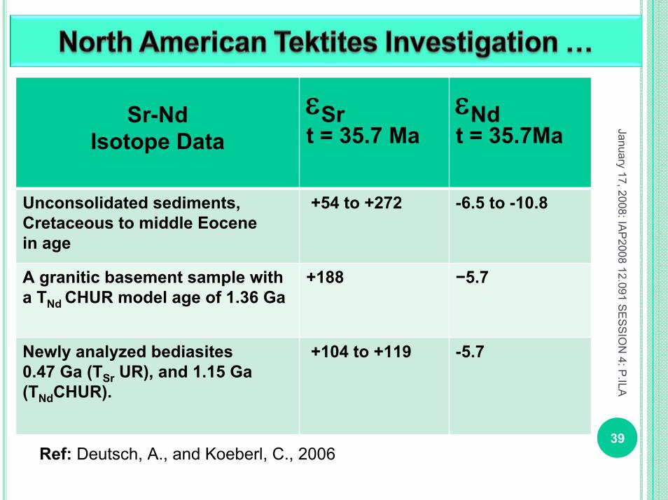
Sr-Nd Isotope Data
εSrt = 35.7 Ma
εNdt = 35.7Ma
Unconsolidated sediments, Cretaceous to middle Eocene in age
+54 to +272 -6.5 to -10.8
A granitic basement sample with a TNd CHUR model age of 1.36 Ga
+188 −5.7
Newly analyzed bediasites 0.47 Ga (TSr UR), and 1.15 Ga (TNdCHUR).
+104 to +119 -5.7
39
January 17, 2008: IAP
2008 12.091 SE
SS
ION
4: P.ILA
Ref: Deutsch, A., and Koeberl, C., 2006

Conclusion …Using the geographic position as well as age and chemical data, previous studies have suggested that the Chesapeake Bay impact structure is the source of the North American tektites (Poag et al. 1994; Koeberl et al. 1996).The Sr-Nd isotope data for samples from the Chesapeake Bay structure establishes a clearcorrelation between this impact structure and the 35 Ma tektites and the associated microtektites from the North American strewn field.
40
January 17, 2008: IAP
2008 12.091 SE
SS
ION
4: P.ILA

Artemieva, N. A.,Tektite origin in oblique impacts: Numerical modeling of the initial stage. In Impacts in Precambrian shields, edited by Plado J. and Pesonen L. J., pp. 257–276, 2002,Berlin: Springer, 2002,ISBN 978-3540435174.Biella, G., Lozej, A., and Tabacco, I., Experimental study of some hydrogeophysical properties of unconsolidated porous media,Ground Water, 1983, v. 21, no. 6, pp. 741-751. 41
January 17, 2008: IAP
2008 12.091 SE
SS
ION
4: P.ILA

De Verteuil, L., and Geoffrey, N., Miocene dinoflagellate stratigraphy and systematics of Maryland and Virginia, Micropaleontology, 1996, v. 42, supplement, 172 p.,ISBN 0-913424-42-0.
Deutsch, A., and Koeberl, C.,Establishing the link between the Chesapeake Bay impact structure and the North American tektite strewn field: The Sr-Nd isotopic evidence,Meteoritics & Planetary Science 41, 2006, Nr. 5, 689–703.
42
January 17, 2008: IAP
2008 12.091 SE
SS
ION
4: P.ILA

Edwards L. E., Horton J. W., Jr., and Gohn G. S., ICDP-USGS workshop on deep drilling in the central crater of the Chesapeake Bay impact structure, Virginia, USA: Proceedings volume. Reston, Virginia: U.S. Geological Survey, Open-File Report 2004-1016, CD-ROM.
Emry, S.R., and Miller, B., Chesapeake Bay impact structure – 35 million years after –and still making an impact, in Edwards, L.E., Horton, J.W., Jr., and Gohn, G.S., 2004, ICDP-USGS Workshop on deep drilling in the central crater of the Chesapeake Bay impact structure, Virginia, USA, September 22-24, 2003: U.S. Geological Survey Open-File Report 2004-1016, CD-ROM.
43
January 17, 2008: IAP
2008 12.091 SE
SS
ION
4: P.ILA

Horn P., M¸ller-Sohnius D., Kˆhler H., and Graup G.,Rb-Sr systematics of rocks related to the Ries crater, Germany,Earth and Planetary Science Letter, 1985, v. 75, pp. 384–392.Glass B. P., North American tektite debris and impact ejecta from DSDP Site 612. Meteoritics, 1989, v. 24, pp. 209–218.Glass B. P. 1990. Tektites and microtektites: Key facts and interferences. Tectonophysics, 1990, v.171, pp. 393–404.Hearst, J.R., Nelson, P.H., and Paillet, F.L.,
Well Logging for Physical Properties, 2nd ed., John Wiley & Sons, New York, 483 p, 2000.ISBN: 978-0471963059 44
January 17, 2008: IAP
2008 12.091 SE
SS
ION
4: P.ILA
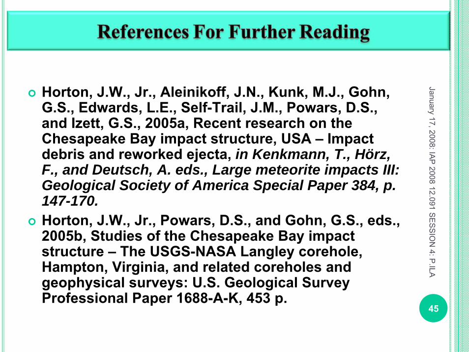
Horton, J.W., Jr., Aleinikoff, J.N., Kunk, M.J., Gohn, G.S., Edwards, L.E., Self-Trail, J.M., Powars, D.S., and Izett, G.S., 2005a, Recent research on the Chesapeake Bay impact structure, USA – Impact debris and reworked ejecta, in Kenkmann, T., Hörz, F., and Deutsch, A. eds., Large meteorite impacts III: Geological Society of America Special Paper 384, p. 147-170. Horton, J.W., Jr., Powars, D.S., and Gohn, G.S., eds., 2005b, Studies of the Chesapeake Bay impact structure – The USGS-NASA Langley corehole, Hampton, Virginia, and related coreholes and geophysical surveys: U.S. Geological Survey Professional Paper 1688-A-K, 453 p.
45
January 17, 2008: IAP
2008 12.091 SE
SS
ION
4: P.ILA

Horton, J.W., Jr., Gohn, G.S., Jackson, J.C., Aleinikoff, J.N., Sanford, W.E., Edwards, L.E., and Powars, D.S., 2005c, Results from a scientific test hole in the central uplift, Chesapeake Bay impact structure, Virginia, USA [abstract]: Lunar and Planetary Science Conference XXXVI, Abstract 2003, 2 p. Koeberl C. Tektite origin by hypervelocity asteroidal or cometary impact: Target rocks, source craters, and mechanisms,In Large meteorite impacts and planetary evolution, edited by Dressler B. O., Grieve R. A. F., and Sharpton V. L. Boulder,Colorado: Geological Society of America, 1994, pp. 133–151.
46
January 17, 2008: IAP
2008 12.091 SE
SS
ION
4: P.ILA

Kettrup B., Deutsch A., and Masaitis V. L., Homogeneous impact melts produced by a heterogeneous target? Sr-Nd isotopic evidence from the Popigai crater, Russia. Geochimica et Cosmochimica Acta , 2003, v. 67, pp. 733–750.
McFarland, E. R., and Bruce, T.S., 2005, Distribution, origin, and resource-management implications of ground-water salinity along the western margin of the Chesapeake Bay impact structure in eastern Virginia, in Horton, J.W., Jr., Powars, D.S., and Gohn, G.S., eds., Studies of the Chesapeake Bay impact structure – The USGS-NASA Langley corehole, Hampton, Virginia, and related coreholes and geophysical surveys: U.S. Geological Survey Professional Paper 1688, p. K1-K32. 47
January 17, 2008: IAP
2008 12.091 SE
SS
ION
4: P.ILA

Montanari A. and Koeberl C.,Impact stratigraphy: The Italian record,Berlin: Springer. 364 p. 2000,ISBN: 354066368.
Paillet, F.L., and Cheng, C.H., Acoustic Waves in Boreholes, CRC Press, Boca Raton, Florida, 264 p. 1991,ISBN: 0849388902.
Poag, C. W., Koeberl, C., and Reimold, W. U., The Chesapeake Bay Crater. Geology and Geophysics of a Late Eocene Submarine Impact Structure. Impact Studies Series. XV, 522 p., 2003, CD-ROM. Berlin, Heidelberg, New York: Springer-Verlag, ISBN: 3540404414 ; DOI: 10.1017/S0016756805260430 48
January 17, 2008: IAP
2008 12.091 SE
SS
ION
4: P.ILA

Powars, D.S., and Bruce, T.S., 1999, The effects of the ChesapeakeBay impact crater on the geological framework andcorrelation of hydrogeologic units of the lower York-James Peninsula, Virginia:U.S. Geological Survey Professional Paper 1612, 82 p.
Powars, D.S., 2000, The effects of the Chesapeake Bay impact crater on the geological framework and correlation of hydrogeologic units of southeastern Virginia, south of the James River: U.S. Geological Survey Professional Paper 622, 53 p. 49
January 17, 2008: IAP
2008 12.091 SE
SS
ION
4: P.ILA
Powars, D.S., Bruce, T.S., Bybell, L.M., Cronin, T.M., Edwards, L.E., Frederiksen, N.O., Gohn, G.S., Horton, J.W., Jr., Izett, G.A., Johnson, G.H., Levine, J.S., McFarland,E.R., Poag, C.W., Quick, J.E., Schindler, J.S., Self-Trail,J.M., Smith, M.J., Stamm, R.G., and Weems, R.E., 2001,
Preliminary geologic summary for the USGS–NASA Langley corehole, Hampton, Virginia,
U.S. Geological Survey Open-File Report 01–87–B, 20 p. 2001.
50
January 17, 2008: IAP
2008 12.091 SE
SS
ION
4: P.ILA
Shaw H. F. and Wasserburg G. J.,Age and provenance of the target material for tektites and possible impactites as inferred from Sm-Nd and Rb-Sr systematic,Earth and PlanetaryScience Letters, 1982, v. 60, pp. 155–177.
Simonson B. M. and Glass B. P.,Spherule layers: Records of ancient impacts,Annual Review of Earth and Planetary Sciences, 2004, v.32, pp. 329–361. 51
January 17, 2008: IAP
2008 12.091 SE
SS
ION
4: P.ILA

52
January 17, 2008: IAP
2008 12.091 SE
SS
ION
4: P.ILA