university of alberta research council of · pdf fileuniversity of alberta research council of...
TRANSCRIPT

University of Alberta Research Council of Alberta Bulletin No. 53. Report No. 56
Soi1 Survey of the
Rycroft and. Watino Sheets BY
WM. ODYNSKY
Research Council of Alberta Soi1 Survey Section
J. D. NEWTON
University of Alberta Depwtment of Soils
Distributed by: Department of Extension, University of Alberta
Edmonton, Alberta, Canada
-J

ALBERTA SOIL SURVEY ADVISORY COMMITTEE
Dr. J. D. Newton, Chairman, Dept. of Soils, University of Alberta.
Mr. W. E. Bowser, Dominion Experimental Farm Service.
Mr. Wm. Odynsky, Research Council of Alberta.
Dr. A. Leahey, Dominion Experimental Farms Service.
This report is published with the approval of the Committee on Agricultural Extension and Publications
of the University of Alberta

CONTENTS Page
Acknowledgment .................................... ....................................................... ......................................................... 5 Introduction ............................ ........................... .............. I.. ......................................................... ..- ............................. 6 Location map ... ..... ............. .... ... ................ ..... ......... ...................................... ........... .... ................ ................... 8 General Description of Area:
Location and Rxtent ... ..... ................................ ...... ..................... ........................................................... 9 Relief ....... ............................................................................................................................ ........ ...................... ...... ,, 9 Drainage ......................... .......... ..... ................ .................................................................................... .................... 10 Transportation ........... ......... ............ ........................ ........ .......................................................... ................ 10 Settlement and Agricultural Development ............................................................... 11 Climate ..................................................................... ........................... ....................................... ................................. 13 Vegetation ......... .._ .................................... .... .._ ................... .................................................................................... 17 Geology and Parent Material ........ ................................................................... ........................... ., 19 Agricultural Problems:
Land Development ..... .............................................................................................. ......................... 22 Water Supply ........... .................................. ..... ..... .................................................................................. 23 Soil Conservation ................................................................................................................................... 24
Soils: Soi1 Development .._ . . . . ......... 25 Soi1 Classification and Mapping _....,........_............,...............................,.....................,,,,,,,.~....,,., 30 Soil Survey Methods . . __...._.................,,,..,.,,,., 34
Description of SO&: Soils Developed on Glacial Till ............................................................................................... 35
Braeburn series ................................................................................................................. ..-.............~ .. 36 Saddle series ...................................... ................ .... ................................................................................... 37
SO& Developed on Stratified Till or Modified Lacustrine Material 33 Donnelly series .......................................................................................................................................... 39 Ether series ..................................................... ..- ......................................................................................... 40 Landry series .... ................ ..... .......... .................................................. .... .............................................. 41
Soils Developed on Lacustrine Deposited Material .......................................... 43 Nampa series ............................................................................................................... ..-....~ ....................... 43 Falher aeries ............................................................................................................................................... 44 Rycroft series ......... .._ ................................................................................................................................... 46 Prestville series ......................... ................. .......... .... ........................... .................................. .......... 47
Soils Developed on Alluvial-Lacustrine Material ............... 48 Judah
Deposited series .............. ..... ... .... ............ ............. . .............................................................. ............... ........ 48
Bronco series .......... ........................................ ...................... ..................................................................... 49 Wanham series .......... .......... ................................ .......... .............................. ... ................................. 50
Soils Developed on Alluvial and Aeolian Deposited Material ............ 51 Davis series ................................................................................................................................................... 51 Tangent series ...................................................... ..-............................- ..................................................... 53 Culp series ..................................... ............................... ................................................................................ 54 Leith series .......................... ^ ....................................................................................... ^. ............................ 55 Sands ..................................................................................................................................................................... 55
Soils Developed on Alluvial Deposited Materials ......................................... 56 Spirit River series ................................................................................... ..- ........................................ 57 Alluvium ............................................................................................................................................................ 57
Soils Developed on Coarse Outwash Materials ........................................................ 58 Clouston series ......................................................................................................................................... 58
Soils Developed on Relatively Thin Alluvial Deposita that Overlie Other Heavier Textured Deposits .............................................. ..................................... 59 Peoria series ...................................................... ... ............................................................... ................... 59 Codesa series ................ .................... ....... .................................................................................................. 60 Belloy series ..................................... ., ..................................................................................................... 61

CONTJZV!CS-Continued Page
Soils Developed on Relatively Undisturbed Residual Materials.. ..... Rahab series ...................... .......................... ..... .......... ... ......................... ..... .. ................................... Kavanagh series ......................................................... ........... .... ....................................... ..- .................
Organic Soila .......... ..... .............. ...... ................................................................................................................. Eaglesham series .................................................................................................................................. Kenzie series ........... I .............I ....................................................................................................... ..~ ........
Description of Mapped Areas .................................................................................................................. Soi1 Rating .................................................................................... ..~ ................................................................................ Mechanical and Chen&al Analysis of SO&:
Mechanical Analysis .......... .... .............. ................. ................ ...................................... .......................... Chemical Analysis ................................................................. ... ..................... ...................... ....................
Glossary .............................................................................................................................................................. -. .............
Seven plates containing 15 figures, a cultivation map and a geology map _...,..,..,..._.._.._..........,..,............,.. ,..,....,.,.................,,,....... .,........... ..,,,............ .._....._........... In centre
Soi1 Map of the Rycroft and Watino sheets, SC& 1 inch to 3 miles, and a Soil Rating Map, scale 1 inch to 4 miles ,..... .._.... Inside Back Cover

ACKNOWLEDGMENT
The soi1 survey of the Rycroft and Watino Sheets was con- ducted as a joint project by the Research Council of Alberta, the Dominion Department of Agriculture and the University of Alberta.
The field work was carried out by Messrs. R. S. Baptie, A. L. Brown*, E. J. Evans, J. Fraser, H. N. Hart, A. Harboway, W. C. Hin- man, B. Hughes, C. J. McAndrews, Wm. Poohkay, H. 0. Ritchie and .A. Wynnyk under the direction of Mr. Wm. Odynsky. The chemi- cal and physioal analyses were made by Messrs. W. C. Hinman, J. N. Leat and T. W. Peters. Mr. S. J. Groot prepared the final copies of the soi1 and soi1 rating maps.
The authors wish to a&nowledge their appreciation of the as- assistance received from the late Dr. F. A. Wyatt, Dept. of Soils, Dr: J. A. Allan, Dept. of Geology, Dr. E. H. Mass, Dept. of Botany and Mr. M. B. Crockford, Research Council of Alberta, University .of Alberta, and Dr. A. Leahey and Mr. W. E. Bowser of the DO- minion Experimental Farms Service.
Acknowledgment is recorded of agricultural and other infor- mation obtained from Provincial and Dominion publications which have been freely used in this report. Extensive use has been made of the preliminary soi1 survey reports of parts of this area.
*Dr. A. L. Brown was Senior Soi1 Surveyor for the Research COUnCil Of Alberta in 1946 and 1947. :

INTRODUCTION
The first reports on the soils of the Peace River area of Alberta were the Research Council of Alberta Reports No. 23 and 31 titled, “Preliminary Soi1 Survey Adjacent to the Peace River, Alberta West of Dunvegan” and “Preliminary Soi1 Survey of the Peace River - High Prairie - Sturgeon Lake Area.” They were pub- lished in 1930 and 1935 and were based on the information obtained by exploratory soi1 surveys conducted in the years 1928 to 1931.
Further soi1 survey work was discontinued in this part of the province until1944. At that time officiais of the Veteran’s Land Act were anxious to explore the settlement possibilities in the area northwest of Fairview, and the Dominion Experimental Farms Service provided them with a soi1 survey party to determine the suitability of the soils in the area under consideration. Since then, soi1 survey work has been continued in the northwestern part of Alberta as a joint project of the Research Council of Alberta, the Dominion Department of Agriculture and the University of Alberta.
This report is based on the information obtained from soi1 sur- veys conducted in the Rycroft and Watino sheets during the sum- mers of 1945,1946 and 1947. It provides an inventory of the soi1 re- sources in the mapped area. The properties of the surface and sub- soi1 of the various soi1 series are described, The first part of each description deals with the characteristics by which the soi1 may be recognized, while the second part discusses the soi1 in relation to agriculture. The report also gives a general description of the map- ped area and deals with the topography, drainage, climate, vegeta- tion and other factors which have a bearing on soi1 development, settlement and trop production. A glossary is included in this report to acquaint the reader with some of the terms frequently used in describing the various soils found in this area.
The soi1 map, printed on the scale of three miles to the inch, is an integral part of this report. It shows the location and extent of the different soi1 series and indicates the most important physical features of the area such as topography, streams, roads, railroads and towns. Two other maps accompany this report; one shows the distribution of the cultivated, abandoned and virgin lands in the area at the time of survey and the other shows a suggested produc- tivity grouping based on a rating of the soils mapped in this area.
The soi1 map and the soi1 rating map should not be used as the sole basis for estimating the value of the land. The information of the survey is not given in sufficient detail to show soi1 variations in individual parcels. However, the maps and report cari furnish in- formation of valuable assistance in determining the characteristics of the soi1 encountered on any particular parce1 within the surveyed area.

Soi1 surveys in Alberta were organized and guided from their inception untill947 by the late Dr. F. A. Wyatt. Those of us privi- leged to carry on cari only hope that this and succeeding reports Will continue to contribute to a better understanding of our soils and their problems, and that they may serve as a useful guide in the development of sound land utilization policies in Alberta.
.--.
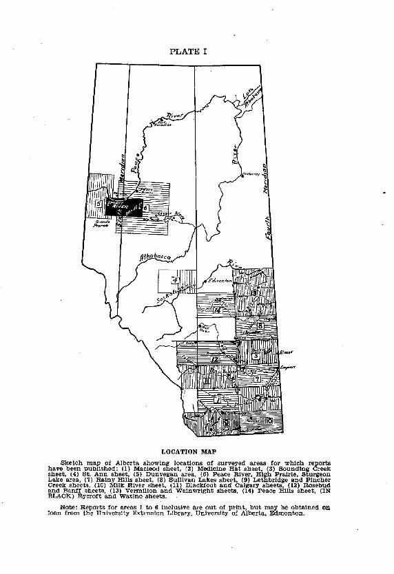
PLATE 1
LOCATION MAP
Note: Reports for areas 1 to 6 inclusive are out of print, but may be obtained on loan from the University Extension Library, University of Alberta, Edmonton.

Soi1 Survey of tbe Rycroft and Watiao Sbebts
GENERAL DESCRIPTION OF THE AREA
LOCATION AND EXTENT The Rycroft and Watino sheets are in the Peace River region
of Alberta. They include part of the former Smoky River and Dun- vegan sheets and caver approximately 2,760 square miles or 1,765,OOO acres.
The general location of the surveyed area is indicated on the sketch map in Plate 1. Its exact boundaries are: on the east, west longitude 117”OO’; on the west, west longitude 119”OO’; on the south, north latitude 55”30’; and on the north, north latitude 56”OO’. It includes a11 or parts of townships 75 to 81 in ranges 20 to 26 west of the fifth meridian and a11 or parts of townships 75 to 81 in ranges 1 to 7 west of the sixth meridian. Donnelly is near the eastern edge and Spirit River is near the western edge of the mapped area. Peace River is about 16 miles north and Fairview is about 5 miles north of the northern boundary while Sexsmith is about 10 miles south and Grande Prairie is about 22 miles south of the southern boundary.
RELIEF The surveyed area consists mainly of the remnants of a till
plain and a lower lying, laking basin which has undergone consider- able alteration adjacent to some of the main drainage charnels.
The till plain remnants are found neighboring Donnelly, Codesa and Spirit River and they form the Birch and Saddle hills. The highest of these is in the vicinity of Braeburn at an elevation of about 3,150 feet above sea level. The horizontal axis of these remnants lies in an east-west direction. The slopes to the lower lying basin are generally long and fairly uniform but, while those on the south sides rarely exceed 5 percent, some of those on the north side often exceed 10 percent-particularly in the Birch and Saddle hills.
The basin varies in elevation from 1,800 feet to about 2,100 feet above sea level and slopes very gently to the main drainage courses. The lower elevations occur adjacent to the drainage courses. These lower areas are usually characterized by a humpy, variable topo- graphy and by materials of alluvial origin. The Upper or remaining part of the laking basin has an undulating to depressional topo- graphy and extends from the lower slopes of the till plain areas to elevations rarely exceeding 2,100 feet. The main part of the laking basin occurs in the vicinities of Falher, Wanham, Rycroft and Peoria.
The most striking relief features of this area are the deep and wide çhannels of the Peace and Smoky rivers and their tributaries. The trenches of thèse rivers vary from one to four miles in width
10 Bulletin No. 53
and at Watino and Dunvegan they attain a depth of about 600 feet below the neighboring upland. Many of the tributary streams have tut trenches that are 200 feet to 300 feet deep and over a mile wide. (See Fig. 2 Plate III). Such trenches are often found rela- tively short distances from the headwaters of these streams.
DRAINAGE The entire mapped area lies in the drainage basin of the Peace
river. This is the largest river in Alberta and it is navigable to river barges for much of its distance. It enters the surveyed area in township 80 range 6 west of the sixth meridian and leaves it in township 80 range 25 west of the fifth meridian. The Smoky river is its largest tributary and joins it about 15 miles north of the mapped area near the town of Peace River. The river bed of the Peace river is in many places about a half mile wide while that of the Smoky river is rarely over a quarter of a mile wide. The Little Smoky joins the Smoky river near Watino. It is the main tributary of the Smoky river and is the only other permanent stream in the mapped area. The remaining tributary streams, shown on the ac- companying soi1 map, are seasonal in character and are often nearly dry during the later summer months.
There are no large fresh water lakes in this area. Lac Magloire north of Falher, and Kakut lake northwest of Heart Valley are both shallow and seasonal in character. They recede during the *
,, summer months and in some seasons may be practically dry. (See Plate VIII, Fig. 3)
Depressional, poorly drained areas are very common through- out the surveyed area. Water accumulates in such areas in the spring but by midsummer most of them are fairly dry. Frequently these ill-drained areas have an accumulation of sedge peat that rarely exceeds a depth of 24 inches. The largest of these sedge peat areas are to be found in the area north of Girouxville, south of Culp, and both north and south of Eaglesham.
Poorly drained areas having an accumulation of moss peat and commonly referred to as “muskegs” are of infrequent occurrence in the Rycroft and Watino sheets.
TRANSPORTATION The main line of the Northern Alberta Railway traverses the
central portion of the mapped area and then proceeds south from Rycroft, cutting across the western portion of the area en route to Grande Prairie and Dawson Creek, B.C. The present outlet for the produce of this area is over the Northern Alberta Railway through Edmonton, The shipping distance from Donnelly to Edmonton is
’ 275 miles while that from Spirit River is 362 miles. The Peace River highway passes through the east side of the
surveyed area by way of Donnelly. This highway is gravelled and extends through Fairview. From Fairview the highway to

Soi1 Survey of Rycroft ad Watino Sbets 11
Grande Prairie is nearly a11 gravelled and passes through the west side of the area just east of Rycroft. The highway from Donnelly to Dawson Creek, B.C. passes through the centre of the area. As yet, it is gravelled only from Donnelly to Girouxville and from Rycroft to Spirit River. The settled portions of the area are gen- erally well supplied with market roads.
The main river courses cari only be crossed by ferry. There are three such crossings in this area: at Dunvegan, Watino, and in section 25, township 75, range 22, west of the fifth meridian. Steel bridges are found only over some of the seasonal stream courses in the western portion of this area.
SETTLEMENT AND AGRICULTURAL DEVELOPMENT From records supplied by M. H. Long, Dept. of History, Uni-
versity of Alberta, it would appear that Fort Dunvegan was estab- lished by A. N. McLeod as a North West trading post in 1805. It served as the main headquarters for the fur traders and mission- aries in the northwestern part of Alberta and remained in use until May, 1918. In 1866 Father Tessier established a Catholic mission at Fort Dunvegan and in 1883 Father Grouard built the log build- ings and church that still remain at Dunvegan. The Anglican mis- sion was established here in 1883 and the first farming was carried on adjacent to these missions. John Gough Briok’s interest and ski11 in agriculture did much to encourage the development and set- tlement of this area.
In the Report of the Peace River Region published by the Geological Survey of Canada in 1904, Macoun states that between 1882 and 188’7 farming on a small scale was attempted at Waterhole at first by the settlers and afterwards by the Hudson’s Bay Company but the efforts were not very successful and were discontinued for some time after 1887. At, the time of his visit in 1903 the only set- tlement of any consequence in the Rycroft and Watino sheets was in the vicinity of Spirit River. About 20 homesteads had been located, mostly along Spirit river and about 200 acres were under cultiva- tion.
The first settlers in this area came in by way of the Athabasca or Grouard trail and the Edson trail. Prior to 1910 the main line of traffic from Edmonton was to Athabasca and then up the Atha- basca and Lesser Slave rivers and across Lesser Slave lake to Grouard. Steam boats were used on the Athabasca river and on Lesser Slave lake while scows were used on the Lesser Slave river. Traffic from Grouard to the mapped area was by wagon roads and trails. The main wagon road from Grouard to Peace River passed by the north east corner of the surveyed area.
During the years 1910 to 1912 a trail was tut from Edson to Grande Prairie and made use of extensively by the early settlers, particularly of the western part of the surveyed area. A land

12 Bulletin No. 53
office was opened in Grande Prairie in 1911 to facilitate handling the first large influx of settlers.
The major portion of the settlement in this area has taken place since the building of the railroad. Steel was laid into Mc- Lennan in March 1915, and extended to Spirit River within a year. During the first few years after this, the increase in settlement was spectacular, particularly in the more open country adjacent to Spirit River, Rycroft, Dunvegan, Wanham, Peoria and Falher. There has been a progressive, though not as rapid, increase in settlement ever since and the movement now is to areas more difficult of access and in which the tree caver is often fairly hea
?% According to the Census of Canada, the population of the en-
tire Peace River region was approximately 3,550 in 1911. By 1912 however the population of the mapped area itself was 3,575. In 1931 this area had a population of approximately 8,750 and by 1941 the population in the Rycroft and Watino sheets had increased to 10,310. In 1946 the population of the incorporated villages in this area was as follows: Falher 279, Rycroft 272, Spirit River 363.
Table 1 gives, in summary, the number of farms, the occupied and the improved acreage in the surveyed area at intervals of time from 1916 to 1941. The data, compiled from the Dominion Census returns, show a very marked increase in the number of farms be- tween the years 1926 and 1931. TABLE L-Number of Fanns, Acres Occupied and Acres Improved in the Rycroft and
Watino Sheets, 1916-1941. ~-
N%izYf Acres AFaYF Acres Percentage of
Year Occupiecl Improved Land Improved
1916 470 106,369 226 17,196 16 . . . . . . . . . . . . 1921 El 213,395 3:: 53,412 25 . . . . . . . . . . . .
1926 _______...._.......... 245,618 84,913 1931 ._._.._,._____________ 2,433 578,570 1936 ..__.__.____________.. 2,210 58;,;;;
ii4 2:%: 35
1941 2 . . . . . . 2,210 310 317:624
Prior to 1926 most of the settlement was in areas immediately neighboring Spirit River, Rycroft, Dunvegan and F&er. Since then, there has been a marked increase in settlement in the outlying areas. A comparison of the data in column 2 and column 4, of Table 1 would seem to suggest a recurrent cycle of expansion and consolidation. The increase in number of farms was greatest in 1921 and 1931. In 1926 and 1941 however, while the number of farms decreased by about 200, the size of the farm holdings in- creased appreciably. This might suggest a consolidation of ho- ings by those farmers remaining in the area. The percentage of improved land increased from 16 percent in 1916 to 46 percent in 1941. The distribution of the improved land in. this area at the time of survey is shown on the cultivation map in Plate VI.
The acreage sown to field crops increased correspondingly as more land was improved. Grain farming is the prevalent type of farming in the mapped area. As indicated in Table 2, wheat,
Ml Survey of Rycroft and Watino Sheets 13
oats and barley occupy by far the largest percentage of the culti- vated land. There has been a steady and very appreciable increase in the acreage devoted to hay crops. Alfalfa and clovers are primarily grcwn for seed production. Census data for the year 1946 were not available at the time of writing this report. However it is estimated that approximately 7 million pounds of forage seed were shipped out of the Rycroft and Watino area in 1948. Approxi- mately 80 percent of this consisted .of clover and alfalfa seed.
TABLE Z-Total Acreage Cropped and Acreage by Principal Crops in the Rycroft and Watino Sheets 1916-1941.
-~~--~ Total
Year Welci Crops Wheat Barley Oats RYe Flax liaY* ac. ac. ac. ac. ac. ac. ac.
1916 . . . . . . . . . . . . . . . . .._................. 13,236 4,392 7,702 127 1921 . . . . . . . . . . . . . . . . . . . . . . . . . . . . . . . . . . . .
S%i 9,361 2.E 26,283 2% E
1926 .______...________._................ 951
28,070 1,653 26,798 320 1 1931 . . . . . . . . . .._........................ 148:720
1,513 81,419 2,472 59,465 538
1936 _.__..________._____............... 155,665 1,859
80,200 7,733 55,887 542 55 1941 . . . . . . . . .._........_................ 202,477
5,402 108,705 13,181 61,893 465 3,222 11,471
*Hay fncludes clovers, alfalfa and a11 cultivated grasses.
The census returns also show that, while the number of live- st.ock increased as more farms were established, this increase was not proportionate to the rate of land improvement. In 1916 there were 1,947 head of cattle and 2,723 hogs in this area, and by 1936 the numbers had increased to 17,029 for cattle and 12,123 for hogs. However by 1941 the number of cattle had declined to 11,078 while the hog population had practically doubled (24,333). The 1948 shipments however would seem to indicate a very marked drap in hog population.
On the basis of the trop reports for census divisions 15 and 16, the following estimates were made of the average yields for this area: wheat 21 bushels per acre, oats 37 bushels per acre, and barley 25 bushels per acre. These estimates include yields produced on many soi1 types and under many different types of farm practice. Some of the better soils should give higher yields and many indi- vidual farmers have exceeded these averages by a considerable margin.
CLIMATE Meteorological data compiled from the Dominion Meteorologi-
cal Records are given in Tables 3 to 6 for two stations in the sur- veyed area and three stations in adjacent areas. The two stations in the area are located at Rycroft and Dunvegan. In both cases the records may not be indicative of the long term average of the Rycroft and Watino sheets. The record for Rycroft is not long enough to be representative, while that of Dunvegan has been taken on the river flat at an elevation about 700 feet lower than that of the surrounding upland plain. The station at Beaverlodge is lo- cated some 50 air miles southwest of Rycroft, the station at Fair- view is about 15 miles northeast of Dunvegan and the station at
14 Bulletin No; 53
High Prairie is about 40 miles southeast of Donnelly. The records for Beaverlodge are the most complete and of the longest duration.
Table 3 gives the average monthly, seasonal and annual precipi- tation at the five recording stations. In this table the year is divided into three sections, namely, the previous fall, winter, and growing season. This is done because it is believed that the moisture of the previous fa11 and the growing season is closely related to the trop growth obtained, whereas that of the winter months is relatively ineffective insofar as growing crops are concerned, since most of it runs off or evaporates during the spring thaw. TABLE 3.-Average Precipitation in Inches. Monthly and Seasonal Distribution for
Points in or near the Rycroft and Watino Sheets.
Beaverlodge Dunvegan Fairview High Prairie Rycroft Elevation 2,484 ft. 1,305 ft. 2,160 ft. 1,968 ft. 1,983 ft.
Years 1914-40 1883-1940 1932-40 1927-40 1931-36
November ...................................... December ........................................ January .......................................... February .......................................... March ..............................................
Winter .................................... April ................................................ Mav ____._ ...........................................
August .____._._.___._<____........................ 1.73 2.12 1.92 September __________._.____.....................
::i5 :z
October _________.__....____............,........... ::1: 24 2.36
0.85 1:34 1.29 Previous Fall ..___.__...____......... - 4.51 - 3.68 -- 5.28 - 5.09 - 5.57
1.18 :::i
1.45 1.25 1.39 1.14 ::65 0.82 1.00 l.oc 1.18 0.76 1.08
- 5.82 - 4.79 - 6.52
1% 0.60 1.03 0.91 1.55
2.08 2.08 2.45 2.15 1.95 2.76
- 6.58 - 5.54 - 7.79
J&e _....___.._....__.._................... . July .___....___._..____,.......... __..._____....._ . .
Growing Season ____.______...____
1.88 1.41
:::7 1.44
- 7.70 1.37 1.70
a.79 = 8.89
Total ____...___.._____............... 16.91 14x1 19.67 22.16
% of Total Occurring in Fall and Grcwing Season _...._.... 66% 66% 67% 74% 65%
The data in Table 3 indicate an appreci.able difference in pre- cipitation between Beaverlodge and Rycroft. However, it must be borne in mind that averages based on records of less than about 25 years duration may not be truly representative of the long time average. Nevertheless, a comparison of the records of Beaverlodge, Fairview and Rycroft shows the following: 65 percent of the aver- age annual precipitation at Beaverlodge, 67 percent at Fairview and 65 percent at Rycroft came in the fa11 and growing season. Thus it would appear that, while the average annual precipitation in the surveyed area compares favorably with that of such points as Ed- monton and Lacombe, the percentage of the total that occurs in the fa11 and growing season is much less since Edmonton and Lacombe get nearly 80 percent of their precipitation during that time.
At a11 the stations reported in Table 3, June and July are the months of greatest rainfall. The total for the two-months averages about four to five inches. This is usually sufficient to produce at least a fair trop, provided sufficient moisture has been conserved to carry the trop into June. Moisture cari be a limiting factor in trop production in this area, and more attention Will have to be

Soi1 Survey of Rycroft and Watino Sheets 15
paid to conservation measures. Stacey* draws attention to the fact that, at the Experimental Station at Beaverlodge during a 29 year period, the April to August precipitation fell below 7 inches in 8 years and was over 10 inches in only 6 of those 29 years. By comparison, Lacombe has about the same annual precipitation as Beaverlodge, but it gets less snow and 3 inches more of summer pre- cipitation. That extra summer precipitation cornes at a very op- portune time with the result that moisture is not as limiting a factor to successful trop production at Lacombe as it is at Beaverlodge.
In addition, it would appear that evaporation is slightly higher at Beaverlodge than it is at Lacombe. Stacey* reports that the May to September evaporation at Beaverlodge in a 21 year average is 16.93 inches, whereas that of Lacombe is 15.39 inches. By com- parison the evaporation at Lethbridge is reported as 24.60 inches and that at Manyberries 33.17 inches for about the same period.
The average amnral snowfall in the mapped area is about 70 inches. The averages of the stations repopted in Table 4 vary from a low of 47.1 inches at Dunvegan to a high of 85.8 inches at Rycroft. The longest and probably most representative average would ap- pear to be that of Beaverlodge at 72.9 inches. As Will be observed, snow has been recorded at some points in every month except July. The average winter snowfall varies from 42.3 to 70.5 inches. Much of this snow is lost in the spring run-off, particularly on cleared and sloping land, and is relatively ineffective insofar as the growing crops are concerned.
TABLE 4.-SnowfalI in Inches. Mmtbly and Seasonal Distribution for Points in Or near the Rycroft and Watino Sheets
Beaverlodge Dunvegan Fairview High Prairie Rycroft AVerege 27 years 21 years 9 years 14 years 6 years
August ............................................ 0.0 0.0 0.0 0.0 September ...................................... October ............................................ $:Y
0.4 4.7 i-5 2.3 1.5 4.6 20
Previoue Fall ........................ - 8.0 - 2.7 -12.2 - 6.1 -11.5 November ...................................... 9.9 6.6 8.5 December ......................................... il.9 9.4 E4 9.3 E:8 January .......................................... 9.9 February ....................................... . ‘9:: 8.4 ‘28
9.7 5.7 E
March .............................................. 11.4 22.3
11.1 12:4 Winter .................................... -55.9 c2.7 32.6 -70.5
April ................................................ 5.7 May. .................................................. 2.3 fi:: ::4 z.7
0:o ::5
June .................................................. 1.0 0.2 July .................................................. 0.0 % 0.0 0.0 ::i
Growing Season .................. - 9.0 - 2.1 - 9.1 - 5.2 - 9.3
Total ................................ 72.9 47.1 84.0 53.9 85.8
The chmate of the surveyed area is characterized by mod- erately warm summer and relatively cold winter temperatures. Table 5 gives the average monthly, seasonal and annual mean temperatures for stations in or near the surveyed area. The yearly mean or average varies from 32.O”F at Rycroft to 34.4”F and 34.3”F
*Climatic Factors Affecting Crop Production. Sci. Agr. 26: 79:82, 1946.

16 Bulletin No. 53
at High Prairie and Beaverlodge respectively. This variation may be due at least in part to the difference in recording periods. Here: again, Beaverlodge had the longest continuous record and its average of 34.3”F should be fairly representative of the surveyed area. In comparison the yearly mean at Edmonton is 37”F, at Calgary it is 38.9”F and at Lethbridge 41°F. Over most of the surveyed area the mean growing season temperature is about 50”F, while the mean winter temperature is about 12°F.
TABLE 5.-Monthly, Seasonal and ~nnual Mean Temperatures (Degrees F.) for Points in CII near the Rycroft and Watino Sheets
Besverlodge Dunvegan Fafrview Hlgh Pra.Irie Rycroft Average 27 years 21 years 9 gears 14 yeq 6 years
August ............................................ September ...................................... October ............................................
Previous Fall ........................ November ...................................... December .________.____: ....................... JEmuary .......................................... February ........................................ March ..............................................
Winter ...................................... April ................................................ May .................................................. June ................................................ July ..................................................
_ Growing Season _.____.__........_
iE 37:o
-47.2 20.5
‘!:A 13.0 21.0
-14.3 36.9 49.5 55.0 57.0 --
49.6
58.2 48.2 37.8 48.1 20.1
4.4 4.7
2::: -10.6 39.2 50.4 57.5 61.0
-52.0
58.2 48.8 37.9
48.3
206:Z 2.0 5.4
19.8 -10.8 37.2 50.6
S%
-50.7
58.1 57.0 48.6 38.2 2;:;
48.3 47.5 21.6 18.0
g 4.0
-5.5
20.8 2E -12.8 - 8.1 37.8 37.5 50.8 55.3 55:5 60.4 59.0
-51.1 -50.0
Total .._____________.____............ 34.3 33.8 33.5 34.4 32.0
Insofar as trop production is concerned, the length of growing season is very important in determining the type of crops that cari be grown successfully. The length of the frost-free period has a con- siderable bearing on the risk of producing certain crops and on the variety of crops that cari be grown. However, in general, the length of the frost-free period is not as long as the growing season. Most farm crops are not damaged when the temperature reaches 32°F. A killing frost is considered as 29°F. It should also be borne in mind that the amount of frost will vary locally with changes in topography. Certain low-lying areas often have fa11 frosts con- siderably earlier than nearby higher land. Similarly, a dense tree caver that impedes natural air drainage seems to increase the haz- ards of frost. Table 6 gives the growing season and frost-free period as reported for the stations in or near the surveyed area. The data indicate that it would be reasonable to assume that the average growing season in the surveyed area is about 110 days, while the frost-free period is about 90 days. A thirty-two year average at Edmonton gives a frost-free period of 95 days and it would appear that frost is not much more serious a factor in limiting trop pro- duction in the surveyed area than it is at Edmonton.
Out of a possible annual total of approximately 4,500 heurs of sunshine, Calgary receives 2,300 hours, Edmonton 2,200 hours, Beaverlodge 2,100 hours and Fort Vermilion about 2,000 hours.

Soi1 Survey of Rycroft and Watino Sheets 17
Such a trend seems reasonable and Fairview should be expected to have about 2,100 heurs. However, for reasons that are not ap- parent, the 10 year average at Fairview is only about 1,700 heurs. Nevertheless, in view of the much longer record at Beaverlodge, it would appear that the surveyed area would have about 2,100 hours of sunshine per year. TABLE 6.-Growing Season and Frost Free Period for Points in or near the Rycroft
and Watino Sheets
Years Growing Season Frost Free Perlod Averaged (days above 29” F) (days above 32” F)
Beaverlodge ........................................................ 19 131 Dunvrgan ............................................................ 13 E Fairview High Prairie
........................................................................................................................
Rycroft .................................................................. Ii
:33 106
iz ii
Wind data for any of the Peace River region are very meagre. Records of wind mileage are available for the years 1932 to 1939 at Fairview and for the years 1936 to 1939 at the Beaverlodge Experi- mental Station. These records show that at Fairview the total average annual wind mileage is 61,217 miles. About 65 percent of the winds corne from a west and southwest direction and May is the windiest month of the year. Winds of gale proportions occur on the average of about twice per year. It is also locally reported that bot dry winds of the Chinook variety occasionally occur .in this district. Beaverlodge on the other hand, has a total average annual wind mileage of 79,643 miles with winds of gale proportions occurring about 18 times per year. The wind velocity averages about 8.3 miles per hour and varies from an average of about 7 miles in the winter months to a peak average of 10.5 miles in May at a time when spring seeded crops are most vulnerable. By way of comparison the Lacombe Experimental Station has a total average annual wind mileage of only 43,000 miles and Avil is the windiest month. Cal- gary averages about 79,000 miles and the Lethbridge Experimental Station about 104,000 miles per year. Winds in the surveyed area should compare fairly closely with those recorded at Fairview.
VEGETATION Generally &e natural vegetation consists of a mixed tree caver
in which aspen poplar is predominant. Balsam poplar, birch, willow, aider, spruce and pine occur either in mixtures or as the dominant caver of local areas. Much of the native caver in this area has been destroyed as the result of both land improvement and unrestricted burning. Prior to the severe fires of the last few years there was sufficient timber in scattered patches throughout this area to supply local demand. Now merchantable stands of spruce and pine occur only as small patches in some of the less severely fire-killed portions of the Birch and Saddle hills and in some of the more remote areas bordering the Peace and Smoky rivers.
In addition to the wooded areas, however, there are fairly ex- tensive parkland areas that consist of woodland bluffs, low shrub
18 Bulletin No. 53
caver and varying amounts of open grassland. Such parkland con- ditions seem to have prevailed in much of the area around Spirit River, Rycroft, Wanham, Heart Valley, Dunvegan and Falher.
The existence of these and other parkland areas within the wooded Peace River region has been a source of major interest for a long time. They were the sites of the berry picking activities of the Cree and Beaver Indians and were commented on by Dawson in the Geological Survey Report of 18’79-1880. He believed that they were produced and maintained by fires and that, before the country was inhabited by Indians, they were tree covered like the rest of the area. Preliminary investigations by E. H. Mass, Dept. of Botany, University of Alberta, indicate that the native vegetation of these northern parklands is similar in many respects to that of the foothills and some of the other parklands of Alberta, but that it lacks some of the leading grass species of the latter areas. Further studies Will be required to determine the species native to the northern parklands and their relationship to the soils in these areas.
The soi1 profile that develops in any one place is the result of the influence of a number of factors, one of which is the native vegeta- tive caver. Thus under heavy woods, soils develop the bleached appearance characteristic ‘of grey wooded soils whereas under a grass vegetation a dark soi1 with a dark surface horizon develops. That is, there is a much greater accumulation of humus under grass than under woods. Degraded black soils are usually found in the transitional belts between the true grassland and woodland areas. It would appear that these soils have been under the influence of tree caver for a much shorter period of time than have the grey wooded soils since they have not had time to lose entirely the black surface horizon that developed under an earlier grass caver.
The occurrence of minor plant associations is very common throughout the wooded area. Such associations are the result of local conditions of climate, soil, topography and drainage. They often serve as good indicators of some of those conditions. For example, areas of sand are generally covered with jackpine, bear- berry and blueberry. Salt grass, gumweed and wild barley seem to thrive in saline areas. Willow, scrub birch, black spruce, tamarack, labrador tea, sedges and mosses are moisture-loving and usually occupy low-lying areas that have a restricted drainage. The presence of some of these plants and the relative abundance of others varies with the amount of moisture present. Poorly drained soils having a variable accumulation of sedge peat are of very common occur- rence in the surveyed area. Many other examples of such associa- tions or soil-plant relationships Will be familiar to those who work with the soils in these areas.
The existence of parkland areas within the wooded region of northern Alberta might be an added exampIe of such an association
Soi1 Survey of Rycroft and Watino Sheets 19
or relationship. +The soils in these parklands are generally dark col- ored and suggest a long continued dominante of grass caver. They have developed on a heavy somewhat saline parent material and are distinguished by a clay pan that is relatively near the surface. Such a clay pan might tend to be unfavorable to the development of a good tree growth and it is suggested that, as a result, trees never did become well established in such areas. Further studies Will be required to determine to what extent such a soi1 condition might inhibit the growth of trees in these and other similar areas.
GEOLOGY AND PARENT MATERIAL The uppermost geological deposits constitute the parent mat-
erials from which the present day soils are developed. They in- fluence the physical and chemical characteristics of the soi1 and its fertility. Consequently, a consideration of their origin and a know- ledge of their nature is essential in the study of soils.
The surface deposits and surface features of the mapped area are the result of erosion and deposition during pre-glacial, glacial and post-glacial times. The general effect of pre-glacial erosion was to remove the beds that may have been deposited subsequent to the Upper Cretaceous period. The beds exposed as the result of this erosion consist of shales and sandstones belonging to the Col- orado and Montana groups of the Upper Cretaceous period. The extent and distribution of the various geologic formations in the Rycroft and Watino sheets is shown on the Geological Map In Plate IX and a detailed description of these formations cari be found in report number 21 of the Research Council of Alberta titled “Geology and Water Resources in parts of the Peace River and Grande Prairie Districts, Alta.” The following excerpts from that report Will indicate some of the characteristics of the dominant formations in the surveyed area:
“The lower shale member (of the Smoky River formation) has the greatest aerial distribution at the surface. It occupies broad areas along both sides of the Peace and Smoky valleys, underlying many of the settled districts, and extends down to river level along the Smoky river south and west of Watino. The member consists of thin bedded, dark to black shales with occasional ironstone and pyrite nodules . . . The Bad Heart member consists of a thin litho- logical unit separating the Upper and lower shale members. It con- sists of medium to coarse grained porous sandstone which is dark red in color . . . The Upper shale member is the uppermost marine shale member of the Cretaceous succession in this part of Alberta.”
“The Smoky River shales weather readily and where they oc- cur along steep valleys, slides and slumgs prevail . . . Decomposition of the pyrite content of these slumped shales gives rise to vapors which condense at the surface, leaving crystalline salts as incrus- tations which are common along the Smoky river near the mouth of the Little Smoky . . . . Much of the crystalline material appears
20 Bulletin No. 53
to be related to the alums and contains a relatively high percentage of magnesium. The water analyses from shale horizons show a high sulfate content and gypsum crystals occur very commonly on ex- posure of the shales.”
“The uppermost formation in this area is the Wapiti . . . It underlies such uplands as the Saddle and Birch hills and these up- lands usually present a steeper slope to the north than to the south since the Wapiti beds dip to the south. The Wapiti formatiop con- sists of sandstones and shales of fresh water deposition . . . . Light grey to buff are the prevailing colors and, on the whole, fine grained textures are most common.”
During the Pleistocene epoch this region was overridden by an ice sheet advancing from the Keewatin ice centre in the vicinity of the Hudson Bay. In passing over the area, this ice sheet mixed the materials accumulated from the underling bedrock and pro- duced large areas with a relatively flat surface by filling in the de- pressions left as the result of pre-glacial erosion. The materials from the underlying bedrock made up the greater portion of the drift in this area and it is thought that the dark colored, saline, heavy textured materials resulting from the weathering of the Smoky River shales contributed the greatest amount to the drift sheet and hence to the soils’ parent material. It is probable also, that more than one glaciation occurred, since the drift forming the parent material of Braeburn soils appears to be underlain by a muoh older till.
Three distinct and different glacial deposits were observed in the surveyed area. The lowest of these is exposed in places along the Ksituan creek and at the base of the Saddle hills near Woking. It consists of a dark yellowish brown compacted sandy clay till that is fairly stony. The stones appear to be predominantly granitic and sometimes there is an accumulation of them in the lower portion of the deposit bordering the underlying bedrock. While this till does not appear to form the parent material of any of the soils in this area, it seems to underly some of the eastern and western por- tions of the area very closely and may be responsible for some of the soi1 characteristics in these areas.
.
The second glacial deposit consists of a greyish brown to brown sandy clay till that is somewhat stony, has numerous coal flecks and may be at least partly derived from the Smoky River and Wapiti formations. This till underlies many of the subsequent deposits in the surveyed area and is exposed most extensively in the Birch and Saddle hills. It forms the parent material of the Braeburn and Saddle soils. Outwash deposits of boulders, sand and grave1 occur as islands or ridges associated with this deposit, particularly in the eastern part of the area both north and south of Donnelly. Near the crown of the Saddle hills however, in section 7, township 75, range 5, west of the sixth meridian, there is a gravelly deposit in

Soi1 Survey of Rycroft and Watino Sheets 21
which the stones are predominantly quartzites and which contains an 18 inch layer of what appears to be bentonite. This deposit is not characteristic of the glacial or more recent deposits in this area, but appears to resemble the Tertiary deposits that cap the Cypress hills in the southeastern part of Alberta.
The third glacial deposit, frequently lying immediately above the preceding ones, consists of a well sorted, stratified till or modi- fied lacustrine material. It is a dark greyish brown clay that has few stones, numerous gypsum crystals and appears to be derived largely from the weathered products of the Smoky River shales. This deposit is remarkably uniform, has few, stones and may have been laid down in a glacial lake during the retreat of an ice front. It forms the parent material of the Donnelly, Esher and Landry soils, and occurs on the lower slopes of the till plain remnants at elevations that are often several hundred feet higher than those of the lacustrine basin.
In the laking basin below the 2,100 foot contour the soils’ parent materials may be of post-glacial origin. The lacustrine grey to dark grey heavy clays are found in the Upper part of this basin at eleva- tions from about 1,900 to 2,100 feet. They are stone free, waxy heavy clays that appear to be derived from the Smoky River shale. Except for the fact that these clays are stone free and somewhat darker colored, they differ very little from the previously described clays. However the occurrence of ill-defined beaches would seem to suggest that this lacustrine deposit was laid down much more recently and may be the result of a reworking of the former parent material. The Rycroft, Falher, Nampa and Prestville soils are de- veloped on this dark, somewhat saline lacustrine parent material.
At elevations usually below the 1,900 foot contour and particu- larly in the areas bordering the major stream courses the parent materials are brownish colored and appear to be of alluvial origin. In some cases these silty and sandy materials appear to have been reworked by wind. The Judah, Davis, Culp and other related soils are formed on this type of parent material.
In addition there are other types of parent material that are important in relatively small local areas. These are the gravelly outwash materials found in association with some of the areas of greyish brown till, the material developed on or in very close as- sociation with the underlving bedrock, other alluvial materials de- posited as relatively thin beds overlying other deposits and the rec- ent alluvium deposited on the river flats.
The period of post-glacial erosion has continued since glacial time and is continuing at the present time. Perhaus the most striking result of post-glacial erosion in this area is the deep dis- section of the broad; nearly flat, areas formed as the result of glacial ’ laking. This dissection has been deepest along the valleys of the major streams where, in addition to cutting through the compar-

22 Bulletin No. 53
ativeIy soft deposits, the streams have deepened their channels into the underlying bedrock formations. Landslides and slumps have followed in the wake of this dissection to produce relatively wide rough areas bordering the stream courses. The eroded materials were carried down the stream courses and partly redeposited in favored locations bordering the stream channels. Such a sorting and redeposition may have been responsible for the parent materials of the brownish colored sandy and silty soils that are found adjacent to the Peace and Smoky rivers. Much more recent examples of this type of redeposition are to be found on the river flats and terraces, the largest of which occur at Watino.
There is apparently a great variation in the total depth of the surface deposits remaining in this area. Weil-log reports would seem to indicate a depth exceeding several hundred feet in the vicinities of Falher and Rycroft. However, in the slight ridges just south of Codesa, Wanham and Spirit River, bedrock may be seen at or near the surface. Similarly it would appear that bedrock is very close to the surface in the vicinities of Kakut la,ke, Heart Valley and Bad Heart.
The depths of the different types of surface deposits are also extremely variable. The greyish brown till deposit is probably deepest on the Birch and Saddle hi&. In some places recent road cuts indicate a depth of till that is in excess of 25 feet. The stratiied till or modified lacustrine material appears to be fairly shallow. Near Esher and Donnelly it rarely exceeds a depth of 10 feet, while in many of the gently sloping areas the underlying greyish brown till may be found close to or exposed at the surface. The dark col- ored lacustrine clay deposit rarely exceeds depths of about 15 feet in the vicinities of Falher and Rycroft. However just east of Don- nelly the underlying till is often found within 24 inches of the sur- face. The brownish colored silty and sandy deposits, adjacent to the Peace and Smoky rivers, are underlain at variable depths either by tiI1 or by dark grey heavy cIay. In some places the dark clay is very close to the surface and forms the parent material of those soils formed in the lower positions of these areas.
AGRICULTURAL PROBLEMS Land Deuelopment: Tree caver is the major impediment to
land development in this area. Until fairly recently it has been necessary for the settlers to resort to slow laborious hand methods and burning to remove the tree caver. By this means the average settler was seldom able to develop more than about five acres per year. Furthermore, the fires a11 too often got out of control and des- troyed much valuable caver and timber.
With the introduction of adaptable power equipment, methods are being developed to bring about a rapid, efficient and inexpensive improvement of bush lands. CIearing by crawler tractor equipment i.8 becoming the full time occupation of many operators within this

Soi1 Survey of Rycroft and Watino Sheets 23
area. Since power equipment has made the clearing of large tracts of bush land relatively easy there is a growing tendency toward the indiscriminate removal of tree caver. Such removal has little more to commend it than uncontrolled burning. Fairly wide strips of un- disturbed caver should be left adjacent to lake beds, along the banks of stream courses, bordering the road allowances and at least up the middle of each section SO that the westerly winds cannot have a clear sweep of the area. Wherever possible additional woodlots should be left to serve as future sources of firewood or as watersheds for farm reservoirs. Due regard is being given to these considerations in clearing the area set aside by the Alberta Government for the settlement of veterans. That area lies between Wanbam and Tangent and is principally north of the railroad. (See Plate VI and Plate IV, Fig. 2 and Fig. 3).
The costs of clearing, piling and breaking vary with the size and density of the tree covér, the size of the equipment and the ef- ficiency of the operator. The custom charges in 1948 averaged about 16 dollars per hour for clearing and piling and about 9 dollars per acre for breaking. Fairly open areas with a light tree caver cari be cleared at the rate of about 4 acres per hour whereas in those areas that have a heavy tree caver the rate of clearing may not ex- ceed 1 acre per hour. In connection with most custom work, the settler himself assumes the task of burning the slashed tree caver and preparing the land for trop after breaking.
Water Supply: Tbroughout much of this area the difficulties experienced in obtaining a suitable water supply have long been a matter of grave concern. Dr. R. L. Rutherford’s study as reported in Research Council Report No. 21 was made in order to obtain data on the possible underground water resources in this and ad- jacent areas. Although he found that the probability of obtain- ing well water was good in the vicinities of the Birch and Saddle Hills and in the Peoria district, many of the Wells have gone dry in the last few years. This has probably been due to the removal of tree caver by fires in the Birch and Saddle hills. Elsewhere in the area he found that the probability of obtaining water from shallow Wells was very remote, and that the water resources of the area could only be determined by drilling test holes to depths often exceeding 1,000 feet.
Drilling deep Wells in any area is a hazardous undertaking unless there is reason to hope for an artesian water supply. Pend- ing further exploration, there seems to be no such assurance in this area even though there is a flowing well in the Whitemud district south of the Little Smoky river. As a result most of the settlers have had to resort to the construction of dams or dugouts to pro- vide themselves with a water supply. (See Plate IV, Fig. 1). When they are of an adequate size and properly looked after, these dugouts and dams seem to be satisfactory sources of water SU~&.

24 Bulletin No. 53
Throughout this area the amount of spring run-off is generally adequate to fil1 up the dugouts providing that some tare has been taken in selecting suitable sites. Engineering advice and assistance such as that provided by the P.F.R.A. in southern Alberta, would be of great help in properly locating these dugouts.
Farmers within this area, complying with the requirements as set out by the Alberta Department of Agriculture, may be as- sisted in the construction of dugouts by means of a subsidy. The requirements, plans of dugouts and filter trenches are discussed in that department’s publication, “Peace River District Farm Water Supply Assistance Policy.”
SoiE Conservation: One of the major agricultural problems is that of conserving our soi1 resources. Usually, under native conditions in which the land has a good protecting vegetative caver, erasion is a gradual, normal process that aids in the forma- tion and distribution of soils. However in this area the depth and width of the many coulees would seem to indicate that normal erosion has been unusually severe due, probably, to a lack of adequate vegetative protection. This should serve as a warning, for if man disturbs the balance of nature by cultivating the land, he exposes the soi1 to the abrasive action of wind and water and thereby materially increases the likelihood of soi1 displacement. Unless adequate measures are taken to guard against abnormal, highly acclerated soi1 erosion, it frequently becomes the most potent single factor contributing to the deterioration of productive land.
In the surveyed area most of the native caver has been destroy- ed by fire. In fact in many of the settled parts of the area firewood has become a scarce commodity. As a result there is nothing left to check the sudden melting and run-off of snow in the spring nor the sweep of the prevailing westerly winds. Without the regulating effect of tree caver many of the streams and la,kes flood in the spring and become practically dry by mid-sumnier. Every effort should be made to protect or re-establish tree caver in areas recommended to be withheld from settlement. In addition all farmed land should have adequate windbreaks. These should be re-established in the settled areas and conserved in the newer areas that are being developed.
In Alberta, soils developed under a woodland vegetation are generally low in plant fibre, humus and nitrogen. It is not ~OS- sible to maintain an adequate supply of fibre and humus in these soils by growing cereal crops year after year on the same ground. In the wake of the decline of fibre and humus follow surface run- off, erosion, poor tilth, inadequate supplies of plant food and poor crops. Grasses Will add fibre while legumes Will also add nitrogen to the soi1 and provide the best source of supply for humus.
Organic matter consists of plant and animal residues whereas humus is produced as the result of the decay of these residues.

Soi1 Survey of Rycroft and Watino Sheets 25
During the summer months this decay is quite rapid and most of the products of decay are lost into the air. Only a very small proportion of the organic matter is left in the soi1 in the more per- manent form known as humus. Good tilth and a lasting crumb structure, that is resistant to the destructive action of water and wind, cannot be maintained unless there is a good supply of humus in the soil. .More humus is produced from materials rich in nitro- gen than from those with a low content of nitrogen. That is, more humus Will be produced from the rotting of one ton of legume resi- due than from one ton of wheat straw. However, since plowing and cultivation speeds up the loss of organic matter, a continuous systematic return of ail available residue is necessary to maintain an adequate supply of humus in the soil.
In an area that has a fairly heavy spring run-off and a growing season in which moisture cari be a limiting factor in trop produc- tion the conservation of that moisture Will not only ensure better yields but Will also help to tut down or eliminate soi1 losses due to water erosion. Organic matter acts much like a sponge in soaking up water, and maintaining a good supply of organic matter Will do much towards making the best use of ail available moisture. Simi- larly, soils that are well supplied with fibre and have good crumb structure are less likely to drift. As indicated in a previous section of this report the wind velocities in this area tend to be high par- ticularly in the early spring and late fall months when the cropped areas have very little protective caver. As a result, soi1 driiing is becoming increasingly serious in many parts of the surveyed area and steps must be taken to curtail further serious losses.
Experimental work to determine the best methods of main- taining or improving the fertility of the soils, and constant atten- tion to conservation measures are of paramount importance in de- veloping a permanent and profitable agriculture in this area. In a following part of this report, dealing with descriptions of various soils mapped in the Rycroft and Watino sheets, attention Will be drawn to considerations that are believed pertinent to the develop- ment of good farm management practices on the soils of this area.
SOILS
SOIL DEVELOPMRNT Soils consist of variable mixtures of weathered rocks and min-
erals, organic matter, water and air. They are the products of the en- vironmental conditions under which they have developed and their characteristics are dependent upon (1) the climate and vegetation (2) the nature of the parent material (3) the relief and drainage (4) the biological activity (living organisms) and (5) the length of time that these forces have been in operation.
Soi1 development is a continuous process that goes on, to a lesser extent, even after the soils have reached a state of near

26 Bulletin No. 53
equilibrium with their environment, The rocks and minerais of the parent material weather and decompose into a more finely div- ided condition. Percolating rains carry down the soluble and finely divided materials and redeposit them at lower depths. Con- current with this there is a return of plant foods by way of the grass and tree roots from the lower portions of the profile. When the plant clies its remains decay and the humus formed tends to collect on or in the surface, giving it a dark color. This humus decays and liberates plant foods that may be carried down by the percolating rain or re-used by the growing plants and other living organisms. Under natural conditions, therefore, soi1 development is a complex and continuous process. On cultivation, however, a completely new environment may be established and, as a result, the whole process may undergo a change and have to attain a new equilib- rium.
The characteristics that a soi1 acquires, as the result of the in- teraction of the various soi1 forming factors, are reflected in the development of more or less distinct layers or horizons. A cross section of these horizons from the surface to the relatively unaltered parent material is known as a soi1 profile. The degree of profile development is dependent on the intensity of the activity of the different soi1 forming factors, on the length of time they have been active, and on the nature of the materials from which the soils have developed. Since one or more of these factors may change from place to place, a great number of different soi1 profiles is developed.
A schematic picture of a soi1 profile, together with the names of the various horizons is given in Plate II. The A horizons are the portions of the profile from which materials are leached by the percolating rain-water and in which, in most soi1 profiles, the or- ganic matter accumulates. The B horizons are the portions in which the materials carried down from horizon A are deposited. As a result of this accumulation the B horizon often tends to be somewhat heavier textured and more compact than the A horizon. Taken together the A and B horizons form the solum, which repre- sents the true soi1 formed by the soi1 building agencies. The C hor- izon is the relatively unaltered parent material which lies in con- tact with the soi1 above.
If the profile is underlaid by geological material which is dif- ferent from that in which the solum has formed, it is designated as the D horizon. These horizons may be further subdivided into A,, A,, A,, B,, B,, B,, etc. depending on differences in the degree of removal and the type of accumulation.
In the Rycroft and Watino sheets the soils have developed under climatic conditions that are favorable to the growth of a woodland vegetation. The accumulated forest litter decomposes slowly and accumulates on the surface. The decomposition pro- ducts contain organic acids which impart to the soi1 an acid re-

28 Bulletin No. 53
color in their surface horizons not unlike that of some of the soils described in eastern Canada.
In addition to those soils developed tmder a woodland vege- tation there are rather extensive areas of darker colored soils re- sembling those developed under a grass vegetation. Under grass, the decomposition products are commonly basic in reaction, the soi1 climate is often less humid and there is less tendency for the or- ganic and minera1 constituents to be leached out of the surface horizons. These dark colored soils occur in relatively large areas and as small patches intimately associated with grey wooded soils. The reasons for their occurrence in areas that are predom- inantly wooded are not entirely apparent. As already mentioned, the nature of the parent material or repeated removal of tree caver by fires may be responsible for what appears to be a long continued absence of tree caver. Further study Will be required to assess the relative importance of these factors in the develop- ment of the northern parkland areas.
Drainage is also an important factor affecting the development of soils in the surveyed area. Under conditions of poor drainage the high water table limits the penetration of air through the soil and restricts the occurrence of living organisms in the soil. Because of these restrictions much of the organic matter accumulates at the surface in a raw state. The subsoil becomes discolored and may show rusty, black or bluish mottling. Such soils, characterized by an accumulation of sedge peat, are of very common occurrence in this area.
The degree of maturity attained by soils varies with the length of time during which they have supported plant growth. The oldest soils in this area are those that have developed on the glacial deposits. Those of intermediate age occur on the higher river terraces while the youngest are developed on the more recent materiaIs deposited on the river flats.
Al1 of these factora help to determine the type of profile that is formed. Each profile has its own specific characteristics and offers its own agricultural problems and potentialities. The fol- lowing summary shows the relation of some of the soil-forming factors to the principal profile types found in the Rycroft and Watino sheets.
’ A. Vegetation and Relief 1. Well drained to moderately well drained topographie positions
(a) Grey Wooded Soils: Developed under a mixed deciduous and evergreen woodland vegetation and consist of profiles that are characterized by a thin or absent A, horizon, a thick, ashy, grey to brownish grey A, horizon and a well developed textural B horizon. Lime carbonate is usually present in the C horizon and may occur in the lower portion of the B horizon. This group of soils may be
Soi1 Survey of Rycroft and Watino Sheets 29
subdivided on the basis of the color and development of the A and B horizons.
(b) Degrcded BEacIc SO&: Developed in areas in which the woodland vegetation has not been as dense nor as well established as in the grey wooded areas. The profile has a ,dark grey to brown A, horizon that is well developed and usually several inches thick. The underlying A, horizon is light grey to greyish brown in color and rarely exceeds a thickness of six inches in this area. The B horizon is generally of a nuciform structure and lime carbonate is usually present in the lower part of this horizon. Differences in color and development of the horizons are used as a basis of separ- ating profile types.
(c) BEack SO&: Developed on non-saline parent materials in areas characterized by a long continued absence of tree covër. The profile has a very dar<k brown to black A horizon and depending on the nature of the parent material, a prismatic or granular structure in the B horizon. The lower portion of the B horizon has a lime carbonate accumulation. Such soils are of infrequent occurrence in this area.
2. Moderately well drained to poorly drained topographie positions (a) Depression Po~&ol: Usually found on the ill-drained de-
pressions and characterized by a profile in which there is a thick, grey A, horizon and a heavy “sticky” B horizon. Rusty streaks are often found throughout the profile.
(b) Organic Soil~: These soils have an accumulation of organic material (peat) overlying a mottled and often rusty streaked min- eral subsoil. Their profiles are identified by the depth and nature of the peat accumulation, Thin peat soils usually have less than 12 inches of peat and are frequently subdivided on the basis of dif- ferences in .the underlying minera1 subsoil. Thick peat soils are true organic soils and the underlying minera1 horizon may be re- garded as a D horizon. Depending on the kind of organic material in the accumulation, they are referred to as sedge peut or moss peat soils.
B. Nature of Parent Material
Parent material exerts a very marked effect on the type of pro- file that is developed in any region. It usually modifies and some- times dominates other soi1 forming factors. The “off-types” refer- red to in the discussion of grey wooded and degraded black soils are often the result of parent material differences. The following profile types are believed the result of the predominating influence of a saline to somewhat saline parent material.
(a) Solmetz: Profile usually found on saline parent material in areas of somewhat impeded drainage. It may occur as the domin- ant profile of fairly large areas or in association with other degraded
30 Bulletin No. 53
black or black soils. The profile has a dark grey to greyish brown A, horizon and sometimes a thin, grey A, horizon. The Upper part of the B horizon is very hard and compact and has a distinct col- unmar structure. The columns often have a well rounded, cauli- flower-like top that is capped with a grey, dense, very hard layer. Lime carbonate and salts are usually present in the lower part of the B horizon.
(b) Solodized Solmetz: Similar to the previous profile except that the upper part of the B horizon is not as hard and there is usually a moderately well developed, grey A, horizon. The lower B horizons are often much more friable than the Upper and lime carbonate and salt accumulations are con-mon in the lower part of the solum. This profile may have a grey, grey-black or black SUT- face and is of extensive occurrence in this area.
(c) Sotod: Profile usually found in the moderately well drained topographie position. It may or may not be related to the two pre- viously described profiles. The parent material is somewhat saline and the profile appears to be a remnant of a solodized solonetz pro- file. It generally has a fairly thick A horizon of which the grey, platy A2 horizon is usually well developed. There is often a yel- Iowish brown A, or B, horizon that consists of blocky to nuciform aggregates while the darker colored B, horizon is friable and has a small blocky to nuciform structure. It occurs in the grey wooded, degraded blaok and black soi1 areas.
SOIL CLASSIFICATION AND MAPPING
Soi1 classification is concerned with the identification and des- cription of soi1 profiles together with the determination of their genetic relationships. Soi1 mapping, on the other hand, involves the determination of the area and extent of those soils characterized by similar profiles. Subsequent groupings cari be made to show similarities relating to parent material, drainage, topography, land use, etc.
In any one zone, parent material and position are generally the most important factors affecting the development of soils. Soils formed on similar parent material have certain common in- herited characteristics. They usually form a specific landscape pattern in which positional differences largely determine the kind of profile that has developed on that parent material. Groups of soils developed on similar parent material are called “soi1 catenas”, whereas the individual soils which make up that catena are caIIed “soi1 series.” The various soi1 series are the result of a variety of local environmental factors that affect drainage, temperature, moisture relationships, vegetation, etc., and give rise to differences in color, depth and structure of the profile. The number of soi1 series’ that are shown on the soi1 map is governed largely by the detail of mapping.

I-toi1 Survey of Rycroft and Watino Sheets 31
Further separations, based on the texture of the surface soi1 or A horizon are called “soi1 classes.” The class name of the soi1 texture, such as loam or clay, is often added to the series name to give the complete name of that soil. However, soils developed on similar parent material usually have a narrow range of texture and further separations into soi1 classes are often unnecessary.
External characteristics and variations that have importance from the standpoint of land use are .known as “phases”. They involve such features as gravel, stoniness, topography, etc., and are often indicated by the use of descriptive terms following the series name.
Soi1 series are given convenient geographic names taken from the localities in which they are found. These include the names of rivers, lakes, towns and districts.
The soils of the Rycroft and Watino sheets were classified and grouped according to the scheme outlined in Table 7. The dominant profiles developed on each type of parent material were given soi1 series names. While the range in texture is indicated for each soi1 series, further separation into soi1 classes was not made in this area. Much additional study is required to determine the relation- ship of some of the processes of soi1 formation and to differentiate between some of the parent materials in this area. For example, the differences between the modified lacustrine and lacustrine parent material may not be sufficiently significant to merit the separation. Similarly it is very difficult to assess the relative importance of the solodic and the podsolic soi1 forming processes in this area. Both result in the development of a leached A, horizon. It is assumed that a greying of the Upper part of the A, horizon is indicative of podsolic degradation while a greying of only the lower part of the A, horizon indicates solodic degradation. In the classification adopted (Table 7), solod and solodized solonetz profiles are sub- divided according to the color and development of their A, horizons. In this respect they resemble other black, degraded black and grey wooded soils and they are classified accordingly. Furthermore, it is assumed that the clay-pan characteristics of these soils are the result of the solodic process and not the result of normal soi1 de- velopment on a heavy parent material. Thus, as knowledge of the soils in this area increases, it is quite probable that numerous ad- justments may have to be made in this classification scheme.
Five topography phases were mapped in the surveyed area and supplementary notes were made on the direction and degree of slope. Since the completion of field work a new topography classi- fication has been recommended by the National Soi1 Survey Com- mittee. In that recommendation slopes are classified as Simple or Complex depending on their uniformity. The first category con- sists of smooth slopes which are subdivided into 7 types ranging from level to very steeply sloping, while the second category con- sists of irregular slopes that are subdivided in a similar manner.

32 ~ Bulletin No. 53
Each of the 7 types is assigned a range in percentage of slope. While the supplementary field notes give this information for many of the areas outlined on the soi1 map, most of the mapped area was not done in sufficient detail to permit the use of this new system of classification. However, the 7 recommended slope groups and their relation to the descriptive terms used in this report are given in Table 7. The overlapping indicates the range of slopes found in the topography phases outlined on the soi1 map.
Approximately 46 percent of the entire mapped area is classed as level to undulating. It consists of predominantly smooth slopes rarely exceeding 1 percent. Much of the area has a “wavy” appear- ance and consists of long smooth slopes broken at infrequent inter- vals by minor irregularities whose slopes do not exceed 2 percent.
The gently rolling areas are generally more irregular and fre- quently have a “humpy” appearance. The irregular portions have variable slopes, usually not exceeding 9 percent, whereas the smooth portions have slopes that rarely exceed 6 percent. Long, smooth slopes are characteristic of the area in and adjoining the Birch and Saddle hills. Gently rolling land covers about 26 per- cent of the total area.
Rolling land covers approximately 15 percent of the total area. If other conditions are favorable, rolling land is considered as arable. Much of the area indicated as rolling consists of low chop- py humps whose slopes are between 8 and 15 percent. Such var- iably choppy topography is common in many of the areas neighbor- ing the Peace and Smoky rivers. Included in this class are those portions of areas whose long uniform slopes have a gradient of be- tween 6 and 15 percent.
Hilly land ma’kes up only 1 percent of the mapped area. It occurs in some of the northern portions of the Birch and Saddle hills and consists of the steepest slopes of those hills. Both uniform and irregular slopes exceed 15 percent and such areas are con- sidered as non-arable.
Eroded land makes up about 12 percent of the mapped area. It consists of the rough land, with variable slopes, that borders and forms the valley banks of stream courses.
The soi1 map is colored on the basis of similar parent material and the soi1 series developed on that material are indicated in clif- ferent shades of that color. Areas consisting of more than one soi1 series receive the color of the dominant series. Organic soils are in- dicated both by color and by the use of symbols. Color is used to designate only those organic soi1 areas that were outlined and sep- arated. The many small areas whose boundaries were not deter- mined are indicated by symbols to suggest the relative distribution of organic soils in the area. A hatchured legend is used to desig- nate tbe topography phases wbile the eroded land is indicated by a solid color.
Soi1 Survey of Rycroft and Watino Sheets 33
Rarely does one soi1 series occur to the practical exclusion of a11 other soi1 series. Soils having different profile types occur in very close association throughout most of this area. In some cases this is due to local dierences in relief and drainage while in others it is due to the close association of different parent materials. Ry- croft, Falher and Nampa soils are good examples of the former whereas Judah and Davis soils are good examples of the latter association. Separation of such intirnate mixtures was not always practicable or possible on the scale of mapping used in this survey. Thus, most of the soi1 areas outlined on the soi1 map consist of mix- tures of two or more soi1 series. The first named is predominant particularly with reference to the color of the surface horizons. In naming the soi1 areas, only the dominant soi1 series are indicated and no consideration is given to those that make up less than about 25 percent of the mapped areas.
Table ‘I-Classification of Soils in the Rycroft and Watino Sheets A. Soils developed on glacial till:
(a) Braeburn-grey wooded, loam to heavy loam. (b) Saddle-degraded black, solod, loam to heavy loam.
B. Soils develeped on stratified till or modified lacustrine material: (a) yo;mmeUy-grey wooded, solodized, heavy loam to clay
(b) Esher-degraded black, solod to solodized solonetz, heavy loam to clay loam.
(c) U.a%;Gblack, solod to solodized solonetz, silt loam to .
C. Soils develoged on lacustrine deposited material: (a) Nampa-grey wooded, solodized, heavy loam to clay loam. (b) Falher-degraded black, solodized solonetz, silty loam to
clay loam. (c) Rycroft-black, solodized solonetz, siIt loam to chiy loam. (d) Prestville-thin peat.
D. Soils developed on alluvial-lacustrine deposited material: (a) Judah-degraded black or brown forest, granular, silt
loam to clay loam. (b) Bronco-black, granular, silt loam to silty clay loam. (c) Wanham-depression podsol.
E. Soils develeped on alluvial and aeolian deposited materials: 1. Calcareous, variable silty parent material that has occasional
sandy strata. (a) Davis-grey wooded, loam to silt loam. (b) Tangent-degraded black loam or brown forest silty loam
to silty clay loam. 2. Calcareous, variable sandy parent material that has occasional
sandy clay strata. (a) Culp-grey wooded, loamy sand to sandy loam. (b) Leith-degraded black, loamy sand to sandy loam.
3. Sand-not differentiated as to profile type or series. F. Soils developed on alluvial deposited materials:
(a) z$r+;aver-black, weakly structured, sandy loam to
(b) Alluviu.&undif’ferentiated recent river deposits.
34 Bulletin No. 53
G. Soils developed on coarse outwash materials: (a) Clouston-grey wooded, gravelly or stony, loamy sand to
sandy loam.
H. Soils developed on relatively tbin alluvial deposits that overlie other heavier textured deposits:
1. Fairly uniform sandy or silty material overlying stratified till or lacustrine deposits.
(a) Peoria-degraded black to black sandy loam to silt loam. 2. Variable sandy to silty shore line material that may contain
grave1 lenses and stones, overlying till or stratified till. (a) Codesa-grey wooded sandy loam to loam. (b) Belloy-degraded black to black sandy loam to silt loam.
1. Soils developed on relatively undisturbed residual materials: 1. Reddish brown sandstone:
(a) Rahab-reddish brown, lithosol. 2. Saline, sandy shale:
(a) Kavanagh-degraded black to black, solonetz, loam to heavy loam.
J. Organic soils: (a) Eaglesham-sedge peat soils. (b) Kenzie-moss peat soils
Topography Phases Percent Slope Mapped Phases
0.0 - 0.5 \ ____________________ _____ _______..._ ____ _____________ . ..Level and undulating 0.5 - 1.5 I
2-5 L ____________._______...~.....~......~...~~~~~~..~. _ __._. Gently rolling 6-9 j 1.. . . . _. . . . ________...____________________________ . . ..Rolling
10 - 15 16 - 30 .___..._........____ _ ___________._____________________ ..Hilly
Irregular, often steeply sloping banks adjacent to drainage courses ____________._______________ _.__ _____.. Eroded
SOIL SURVEY METHODS
The soi1 survey of the Rycroft and Watino Sheets was carried out by making traverses at intervals of one mile wherever possible. Traverses were made by car, on foot and, where necessary, by saddle horse. In the last case the traverse interval and the route was very irregular and the information thus obtained was of an exploratory nature.
Test holes were dug at frequent intervals in order to deter- mine the texture, color, depth and structure of the various horizons. Wherever possible, cutbanks, dugouts and other excavations were examined to determine the characteristics of the parent materials. Additional notes were made on the nature and density of caver, stones, drainage, the approximate acreage under cultivation and the topography and direction of slope. The soi1 boundaries were determined from the information gained at thé test holes and from observations of the physical features of the land. After the boun-

Soi1 Survey of Rycroft and Watîno Sheets 35
daries of the various soi1 areas had been established, samples representative of the larger areas were collected and brought to the laboratory for analysis.
During the survey of this area, aerial photographs were made available through the courtesy of the Dominion Experimental Farms Service. These photos have been used extensively not only in checking completed areas but also as a very helpful aid in surveying new areas. Eroded land, tree caver, cultivated areas and areas of peat soils were outlined from the photographs and then checked at the time of survey.
In a survey carried out in this manner and recorded finally on a map of the scale of three miles to the inch, small areas can- not always be accurately established. In the accessible portions further inspection should be made in determining the soi1 types on individual quarter sections. In the more remote parts, that were done by saddle horse, the soi1 boundaries are conjectured and the areas should be re-examined as soon as conditions warrant. The conjectured soi1 boundaries are differentiated on the soi1 map by broken lines and should not be confused with those that are fairly well established.
DESCRIPTION OF SOILS
A. Soils Developed on Glacial Till The Upper till in the Rycroft and Watino Sheets consists of
greyish brown to brown, fairly uniform material that appears to be derived largely from the Wapiti and Smoky River formations. It has some stones, occasional coal flecks, and its texture is domin- antly a clay loam. It occurs in the “upland” portions of the mapped area and consists of the erosional remnants of what may have been a former till plain. On the east side of the mapped area the till deposits occur at elevations that are from 50 to 200 feet higher than the surrounding basin, while in the Saddle hills, near Brae- burn, they are about 1,200 feet higher. Except for some portions of the Birch and Saddle hills, the slopes from these upland areas are generally long and uniform and rarely exceed a gradient of 8 percent. At the lower elevations this till deposit underlies the brownish grey modified lacustrine material. The depth to the till, in these lower areas, is very variable and in some places it is exposed at the surface. This patchy occurrence of till is quite common and the soils, in such areas, are developed on mixed parent materials.
The dominant soils formed on this till deposit are those of the Braeburn and Saddle series. However, associated with them are soils formed in the depressional areas and sedge or moss peat soils, In addition soils of the Donnelly and Esher series are often found in close association with those of the Braeburn and Saddle
38 Bulletin No. 53
series. The following is a description of the dominant soi1 series formed on the glacial till in this area:
(a) Braeburn Series: (Grey wooded loam to heavy loam) Soils of the Braeburn series predominate on about‘ 228,000
acres of the mapped area. They occur at the higher elevations of the eastern and southwestern portions of the area, and appear to have developed under a fairly heavy tree caver consisting chiefly of aspen poplar and spruce with some pine, birch and occasional balsam. Fire has destroyed this caver in a11 but some sheltered portions of the Birch and Saddle hills. While most of the Braeburn soi1 areas have an undulating to gently rolhng topog- raphy, some of the slopes from the crowns are quite steep and variable. These are indicated on the accompanying soi1 map.
Braeburn soils are fairly well drained, grey wooded soilç that have a moderately thick, greyish, leached A, horizon and a yellow- ish brown to greyish brown, fairly heavy textured B horizon in which a lime concentration horizon is found at depths of 36 to 48 inches below the surface. Stones are found throughout the profile but, although significant, they do not usually occur in sufficient numbers to be an undue obstruction to cultivation. The stones are chiefly granites and quartzites and vary in size from small pebbles to large boulders. The following is a generalized descrip- tion of a Braeburn soi1 profile:
Horizon A.3
Depth in Inches
O-l%’
A1 l$-2
AL 2-6
AZ. 6-8
BZ
B,
8- 14
14 - 34
&a
C
34 - 40
40-
Description Dark greyish brown to very dark brown de- composed and semi-decomposed leaf litter. pH 6.6 to 7.0 Greyish brown loam with little well defined structure. Usually too tbin to be sampled and often absent. pH 6.2 to 6.6 Light yellowish brown very fine sandy loam that is often gritty and sometimes contains iron concretions. It is friable and has a fairly well developed platy structure. pH 5.8 to 6.2 Yellowish brown silt loam. It is fairly loose and often has a well developed vesicular nuci- form structure. pH 5.2 to 5.8 Dark yellowish brown clay loam to clay- weakly columnar, nuciform. nH 5.0 to 5.3 Dark $ellowish brown to greyish brown loam to clay loam that has occasional streaks or pockets of sandy loam or silty clay loam. It is fairly loose and has a nuciform structure. The aggregates are smaller than in the B2 hori- zon and frequently contain imbedded coal flecks. uH 5.8 to 7.0 Greyish brown loam to clay loam with occa- sional bands of dark grey clay. Often spotted or streaked with lime. pH 7.5 to 8.0 Greyish brown to yellowish brown clay loam till. pH 7.8 to 8.2 .

Soi1 Survey of Rycroft and Watino Sheets 37
Stones of varying size are present in a11 horizons. On cultiva- tion the surface soi1 is a greyish brown to yellowish brown color and tends to bake and trust on exposure.
Agricultural Use: Exclusive of the steepest and roughest phases, Braeburn soils are generally fair to fairly good arable soils. Only a very small proportion of them is being farmed at the present time. This may be due to the fact that until fairly recently the Braeburn soi1 areas have had a fairly heavy tree caver. However, even with much of that caver destroyed by fire, it would seem desirable to withhold from settlement the crowns and Upper slopes of such portions of the Braeburn areas as the Birch and Saddle hi&. If these areas were protected and reforested they would eventually supply good timber and aid in replenishing the dwindling ground water supply of the neighboring areas.
Braeburn soils are relatively low in natural fertility. As a result of the leaching process, by which these soils have formed, many of the soluble plant foods have been removed from the Upper horizons and redeposited in the lower horizons. Consequently the B horizons are generally better supplied with minera1 plant food elements than are the A horizons. Furthermore, the organic material developed under a woodland vegetation is not as fibrous nor as stable as that developed under grass caver.
The addition of organic matter and the return of deficient plant food elements are therefore the prime requirements asso- ciated with the successful cropping of Braeburn soils. Crop rota- tions that include grasses and legumes Will help fulfill these requirements. In addition, present information indicates that occa- sional supplementary applications of commercial fertilizers are proving beneficial. More field trials are needed to determine the fertility requirements of Braeburn soils. However, they are adequately drained soils and their subsoils are generally fairly well supplied with most of the required plant food elements. Con- sequently they should respond very favorably to good manage- ment practices.
(b) Saddle Series: (Degraded black loam to heavy loam) Soils of the Saddle series predominate in about 12,000 acres
of the mapped area. They occur on some of the lower slopes and on some of the isolated renmants of the till plain. On the lower slopes they frequently occur in association with Esher and other soils but they are not often predominant in such areas. They are also found in association wit.h Braeburn soils in some of the more sparsely wooded portions of the area.
Saddle soils are fairly well drained, degraded black soils that have a well developed dark colored A, horizon, a yellowish brown A, horizon that is rarely more than 6 inches thick, and a yellowish to greyish brown B horizon that is often fairly compact in the

38 Bulletin No. 53
upper 6 inches. Stones are found throughout the profile but rarely occur in sufficient numbers to be an undue impediment to cultivation.
The following is a description of a Saddle soi1 profile. It is a - solodic profile.
Depth Horizon in Inches
A0 o-1 A11 1-5
AU 5-7
A2 7 - 10
AO 10 - 12
B? 12 - 18
333 18 - 30
Bca 30 - 36
4-T 36 - On cultivation the
brown in color.
Agricultural Use: .
Description Dark brown to black leaf litter. pH 7.0 Dark brown to black loam, weakly prismatic, crushes easily to small crumbs. pH 6.0 Greyish bro&n loam, weakly prismatic.
pH 5.5 Yellowish brown very fine sandy loam, platy in the Upper 2 inches to vesicular nuciform in the lower 1 inch. pH 5.3 Yellowish brown clav Ioam. vesicular. nuci- form. Aggregates OC&~ in &Mers and may be tops of old columns. pH 4.5 Dark yellowish brown clay to clay loam, weakly columnar, nuciform to blocky, firm.
pH 4.8 Dark yellowish brown to brown clay loam, weakly prismatic nuciform to blocky, friable.
pH 6.5 Brown to greyish brown clay loam, small nuciform to blocky, friable, medium lime content. pH 7.8 Greyish brown clay Ioam’ till. pH ‘7.8 surface soi1 is greyish brown to dark greyish
Saddle soils have a higher native fertility and as a result are more desirable for agricultural purposes. How- ever, every precaution should be taken to see that their native productivity is maintained. These soils are adapted to a mixed farming agriculture and the common practice of cereal-fallow rotation should not be continued.
B. Soils Developed on Stratified TilI or Modified Lacustrine Material This material consists of a dark greyish brown, fairly uniform
clay deposit that appears to be derived largely from the Smoky River formation. Further study is required to determine its mode of deposition and its relation to the till and lacustrine deposits in this area. It is very similar to the lacustrine deposited material except that it is somewhat browner, less compact and has a few stones. The parent material is stratified and frequently the yellowish brown, sandy clay to clay loam strata are quite stony. The stones are usually small and predominantly granitic. Variable depths of this deposit overlie the lower slopes of the till plain remnants at elevations ranging from 2,100 feet to about 2,400 feet

Soi1 Survey of Rycroft and Watino Sheets 39
in the eastern part and up to about 2,600 feet in the western part of the mapped area. In addition, similar, highly sorted and often stratified deposits are found in many of the small, low-lying basins that occur in the previously described till areas. The soils formed on this parent material may merge gradually with those formed on till or lacustrine materials or they may be separated from them by soils formed on relatively shallow overlying deposits of gravelly or sandy materials.
The following is a description of the three dominant soi1 series formed on this stratifeid till or modified lacustrine material:
(a) Donnelly Series: (Grey wooded heavy loam to clay loam) Soils of this series predominate in about 98,000 acres of the
mapped area. No estimate is made of the extent of their occurrence in the many areas in which they are not predominant. They occur adjacent to or in association with the till areas in the eastern and western portions of the mapped area, and are found on level to undulating and depressional topography. The native caver appears to have consisted of aspen poplar in which there were variable proportions of black poplar, spruce, willow, aider, birch and various shrubs. Much of this caver is removed as the result of agricultural development or destroyed by fires.
Donnelly soils are imperfectly or somewhat poorly drained soils. They have a grey, solodized profile in which there is a thin or absent A, horizon, a grey A, horizon seldom exceeding a thick- ness of about 4 inches and a grey to greyish brown nuciform AB or B, horizon. The remainder of the solum consists of a dark yellow- ish brown to dark greyish brown clay that is fairly compact, nuciform to small blocky, and in which small stones are of common occurrence. The lower part of the B horizon is often much darker colored than the Upper part and this color change may be quite abrupt. Accumulations of lime and salts are found at depths of 24 to 36 inches. The parent material is variable in color and may be predominantly brown or predominantly grey depending on the thickness and distribution of the yellowish brown and dark grey strata. The following is a description of a Donnelly soi1 profile:
Depth Horizon in Inches Description
A0 o-1 Dark brown leaf litter. pH 6.7 A1
A?
As(BJ
l-2 Dark greyish brown to dark grey heavy loam to clav loam with little well defined structure. May be absent. pH 6.6
2-4 Light yellowish brown very fine sandy loam, medium to coarse platy, easily crushing into small irregular fragments. pH 5.9
4-7 Light yellowish brown loam to clay loam, medium nuciform, vesicular, friable: pH 5.3
40 Bulletin No. 53
Depth Horizon in inches Description
B2 7- 13 Dark yellowish brown clay, tieakly columnar, fine nuciform to blocky, firm to very firm. pH 5.1
B3 13 - 19 Dark yellowish brown to dark brown clay, fine to medium blocky, firm. pH 5.1
B1 19 - 25 Greyish brown to dark grey clay, fine to me- dium blocky, firm. pH 7.2
&a 25 - 33 Greyish brown to dark grey clay with occa- sional yellowish brown sandy clay loam strata. Moderate lime. pH 8.0
Bsoa 33 - 39 As above with accumulation of salts. pH 7.8 C 39 - Grey clay with occasiona thin strata of yeI-
lowish brown sandy clay loam. pH 7.8
A few small stones are usually present in a11 horizons. On cultivation the surface soi1 ‘is brownish grey in color and tends to bake and trust on exposure.
Agticuitud Use: Donnelly soils are fairly good to good arable soils. However, their surface horizons tend to be low in organic matter and minera1 plant foods while their subsurface horizons tend to have a restricting influence on the penetration of water and of plant roots. Crop rotations that include deep rooted crops such as legumes Will help to open up the subsoil and thereby improve the natural drainage and structure of these soils.
Fertility experiments are being conducted on similar soils by the Beaverlodge Experimental Station. While these experi- ments have not been continued long enough to be conclusive, they do indicate a favorable response to applications of manure and to applications of phosphate fertilizers.
(b) Esher Series: (Degraded black heavy loam to clay loam) Soils of this series predominate in about 65,000 acres of
the mapped area. They are found in the eastern and western portions of the area mainly in association witb or adjoining Don- nelly and Falher soils. Their native tree caver appears to have been considerably more open than that of the Donnelly soils. Esher soils have undulating to gently rolling topography in which the slopes are usually smooth and seldom exceed a gradient of 5 percent. They are moderately to imperfectly drained soils and are found in positions that are better drained than those in which Donnelly soils are found.
Esher soils are degraded black soils that have a solod to solodized solonetz type of profile. They usually have a well devel- oped A, horizon that is greyish brown to .dark brown in color, a light brownish grey platy A, horizon and a nuciform A, horizon. The B horizon is often very compact although it tends to break fairly readily into fine blocky to nuciform aggregates. Distinct horizontal cleav- age lines are common in the lower B and C horizons. Occasional

Soi1 Survey of Rycroft and Watino Sheets 41
stones are found throughout the profile. Accumulations of lime and salts are usually found at depths of 24 to 36 inches. The follow- ing is a generalized description of an Esher soi1 profile:
Horizon Depth in Inches
Ao o-1
Al l-4
A, 4-7
BP 7- 11
B3 11 - 17
Bd 17 - 24
B.3 24 - 36
&a 36 - 48
C 48 -
Description Dark brown to black decomposed and semi- decomposed leaf litter. pH 7.0 to 7.6 Dark brown to brown silt loam to clay loam, weakly prismatic, breaking readily to weakly nuciform aggregates. The color of this horizon is often greyish, and quite variable but the depth rarely exceeds 6 inches. pH 5.9 to 6.3 Light yellowish brown silty loam, platy in the Upper 2 inches to vesicular nuciform in the lower 1 inch. There is often a deeper and more distinct A horizon. pH 6.0 to 6.2 Dark yellowish brown clay-often silty. Me- dium columnar breaking into fine nuciform aggregates. Cleavage faces stained a dark brown. pH 5.0 to 6.0 Dark yellowish brown to dark brown clay, compact, weakly nuciform to massive. pH 5.5 to 6.5 Greyish brown to dark grey clay, compact, weakly nuciform to massive. pH 7.0 to 7.5 Greyish brown to dark grey clay tiith occa- sional bands of yellowish brown clay loam. Friable, small nuciform. pH 7.5 to 8.0 Greyish brown to dark grey clay loam to clay. Medium lime content. pH 7.9 to 8.1 Greyish brown to yellowish brown clay loam to clay. Frequently mixed with bands of dark grey clay. Lime and salt pockets common. pH 8.0 to 8.3
On cultivation, the surface soi1 is greyish brown to dark grey- ish brown in color.
AgricuZturaE Use: Esher soils have a higher native fertility than the Donnelly soils and most of the areas in which they pre- dominate are now under cultivation. They are good arable soils but their fibre content is generally fairly low and their B horizon is often very compact. While these soils have been cropped suc- cessfully for a number of years, yields are decreasing and losses due to wind and water erosion are increasing on many of these soils. Crop rotations that include grasses and legumes Will help to curtail these losses, replenish the organic matter and minera1 plant food supply, and improve the drainage and structure of these soib.
(CI Landry Series: (Black silt loam to clay loam) Landry soils are found mainly in the west central and north-
western portions and predominate in about 25,000 acres of the mapped area. They appear to have developed in the better drain-

42 Bulletin No. 53
ed, more open parkland portions of the area. They have an undulat- ing topography that consists of long smooth slopes whose gradient seldom exceeds 5 percent.
In many respects a Landry soi1 profile is very similar to that of an Esher soil. However, the A, horizon is usually thicker and darker in color. It is very dark brown to black and its average thickness is about 6 inches. Like the Esher soils they have a solod to solodized solonetz type of profile in which there are occasional small stones. Frequently their parent material appears to be a mixture of both yellowish brown till-like material and dark grey clay, with the latter predominating. The following is a generalized description of a Landry soi1 profile:
Horizon A,
A2
Depth in Inches
O-6
6-8
AsU%) 8- 10
B2 10 - 18
B3 18 - 26
Bca 26 - 36
C 36 -
Very dark brown to black, silt loam to clay loam, crushes easily to small crumbs. pH 6.8 Dark greyish brown grading to yellowish brown silty loam, fine to medium platy, very friable. pH 6.2 Yellowish brown clay loam, vesicular, nuci- form, fairly firm, often occurs in loose clus- ters. pH 6.2 Dark yellowish brown to dark brown clay, often silty. Medium columnar breaking into very firm nuciform to small blocky aggregates that often have a waxy or glazed appearance. pH 6.0 Very dark greyish brown and dark brown clay, coarse nuciform to blocky, firm. While the vertical cleavage lines are usually indis- tinct, there are often very pronounced hori- zontal cleavage lines at varying intervals in this and the succeeding horizons. pH 7.0 to 7.5 Dark grey clay in which yeJ.lowish brown sandy clay loam strata are of common occur- rence. These may also occur in the lower part of the preceding horizon. Moderate concentra- tions of lime are usually found in these lighter colored strata and salt inclusions are common in the lower part of this horizon. pH 8.0 Dark grey and yellowish brown stratified clay to clay loam. pH 7.8
Agricuhral Use: Landry soils are among the most productive soils in the mapped area. They have a fairly high natural fertility and are good to very good arable soils. However, every precaution should be taken to see that their relatively high natural fertility is maintained.
Unfortunately it would appear that the best soils in this area are the last to receive conservation attention. The grain summer- fallow system of farming is practised almost exclusively on such

Soi1 Survey of Rycroft and Watino Sheets 43
soils. Landry soils are well adapted to a mixed farming agriculture and if their natural fertility is to be maintained the grain-fallow rotation should be discontinued.
C. Soils Developed on Lacustrine Deposited Material This parent material appears to be derived from materials that
are mainly of Smoky River origin. It is a grey to dark grey clay that is quite compact and has a waxy or glazed appearance. Occasional thin strata of yellowish brown silty loam to silty clay loam occur in some parts of this deposit. While this material is often very similar to the modified lacustrine material it is usually more compact, darker in color and stone-free. It is found at elevations of from 1,950 feet to 2,100 feet and may be separated from the modified lacustrine deposits by areas in ‘which there is a relatively shallow overlying deposit of sandy or gravelly material.
The soils developed on this lacustrine material have a solodized solonetz or clay pan type of profile in which salts are often found just below the horizon of lime accumulation. Areas of these soils have a parkland vegetation consisting of grasses, shrubs, willows and poplar. The growth of the latter appears to have been retarded and it has been suggested that the development of a solonetzic profile may have been partly responsible for inhibiting tree growth in such areas.
These soils are imperfectly to poorly drained and have a level to undulating and depressional topography. In addition it would appear that micro relief is an important factor determining the color of the profile that is formed on this parent material. For example, grey wooded soils are found in the lower positions, degraded blaok soils on the better drained slopes and black soils on the crowns and best drained positions. This is particularly apparent in the Falher area. The grey soils formed in the lower positions are not unlike depression podsols but their profile is difficult to distinguish from that of other grey wooded soils devel- oped in large areas where drainage deficiencies are less apparent.
Following is a description of the four main soi1 series formed on this lacustrine deposited parent material:
(a) Nampa Series: (Grey wooded heavy loam to clay loam) There are only a few areas, comprising a total of about 30,000
acres, in which Nampa soils are predominant. In addition, however, minor proportions of most of the Falher and Rycroft soi1 areas and many of the Judah and Davis soi1 areas consist of Nampa soils. No attempt is made to determine their relative distribution in such areas.
Nampa soils are poorly drained and are fou.nd in level and depressional areas. Their profile is quite similar to that of Don- nelly soils except that the B horizon tends to be more compact and usually not as brown in color. The brown coloring is evident

44 Bulletin No. 53
in the Upper part of the B horizon and merges gradualIy into the grey to dark grey colors characteristic of the parent material. The following is a description of a Nampa soi1 profile. It is a solodized profile in which the color of the A horizons resembles that of other grey wooded soils.
Depth Horizon in Inches
A0 o-1 A* l-2
A2 2-4
As(B1) 4-8
BP 8- 15
B3 15 - 22
B, 22 26 -
Bca 26 - 30
Bsor 30 - 34
Description Dark brown leaf litter. pH 5.8 Greyish brown heavy loam to clay loam, nuci-. form, friable-often absent. pH 5.5 Light brownish grey very fine sandy loam to silt loam, medium to coarse platy, friable, often iron stained. pH 5.2 Light brownish grey to light yellowish brown silt loam to silty clay loam, vesicular, nuci- form, fairly firm. Aggregates often occur in clusters and may be tops of old columns. pH 5.0 Dark greyish brown to dark yellowish brown, clay to silty clay, weakly columnar, medium nuciform to blocky, very firm. pH 5.2 Dark greyish brown to dark grey clay, coarse nuciform to blocky, very firm. pH 7.6 Dark grey clay, fine to medium blocky, firm. pH 7.5 Dark grey to very dark grey clay to silty clay loam, fine to medium blocky, friable. Lime in pockets or in the thin silty strata when these are present. pH 7.6 As above but with gypsum accumulation. pH 8.0
This profile has very few to no stones. The cultivated top soi1 is usually greyish brown to light brownish grey in color.
Agricultural Use: Nampa soils are fairly good arable soils. They tend to be low in organic matter and they have an unfavorable subsoil that tends to retard the penetration of water and of plant roots. Water penetration is slow and during heavy rains the sur- face of Nampa soi1 areas often becomes submerged. Its retarding effect on root penetration is particularly apparent when the soi1 is rather dry. Deep breaking, followed by the periodic inclusion of deep rooted legumes in the trop rotation Will help to open up and materially improve the structure and natural drainage of these soils. Experimental information dealing with cultural practices on these and other solodized solonetz soils is very badly needed.
(b) Falher Series: (Degraded black siity loam to clay loam) Falher soils predominate in about 201,000 acres of the mapped
area. They rarely occur to the exclusion of either Nampa or Rycroft soils, However the dominante of the respective series varies appreciably and the soi1 ‘areas, appearing on the soi1 map,

PLATE III
Fig. l.-Tree caver fairly typical of a considerable proportion of the virgin land in the Rycroft and Watino sheets. Much of it has been fire-killed.
Fig. 2 .-Eroded land near the junction of Kakut creek with the Bad Heart river. Deep wide coulees are characteristic of the drainage courses in this area. Destruction of protective tree caver along the banks results in increased soi1 erosion. and offers no Fheck to the spring run-off from rapidly melting snow. The smaller streams in this area flood in the spring and are practically dry by midsummer.
Fig. t.-Sedge bogs of varying size are of common occurrence throughout the mapped area. Hay is made on some of them. The soils in these areas have an accumulation of sedge peat that rarely exceeds a depth of 24 inches.
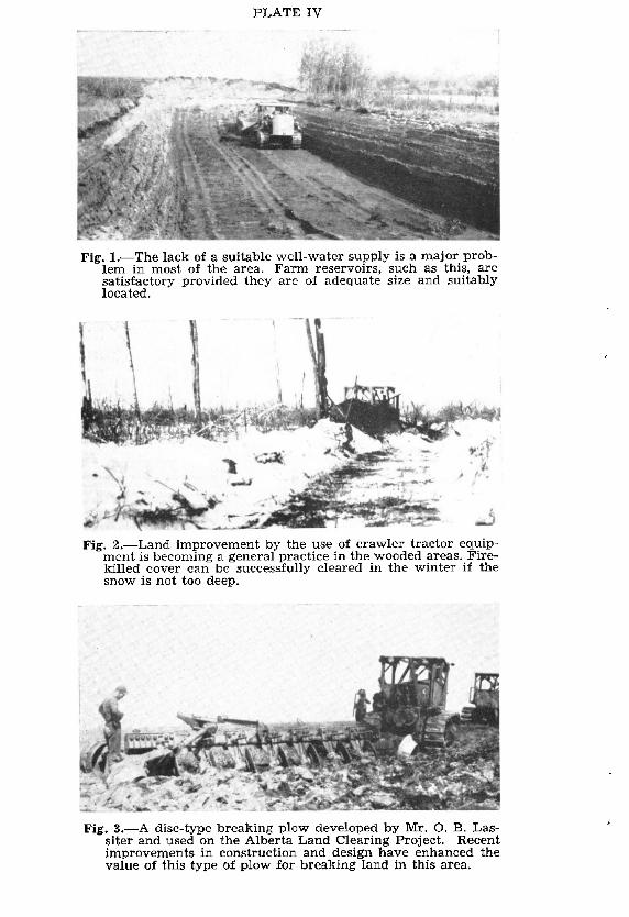
PLATE IV
Fig. l.-The lack of a suitable well-water supply is a major prob- lem in most of the area. Farm reservoirs, such as this, are satisfactory provided they are of adequate size and suitably located.
Fig. Z.-Land improvement by the use of crawler tractor equip- ment is becoming a general prxtice in the wooded areas. Fire- killed caver cari be successfully cleared in the winter if the snow is not too deep.
Fig. 3.-A disc-type breaking plow developed by Mr. 0. B. Las- siter and used on the Alberta Land Clearing Project. Recent improvements in construction and design have enhanced the value of this type of plow for breaking land in this area.

Fig. I-A deep road tut showing a profile fairly typical of the Judah series. A brownish colored fairly deep A, horizon, a yellowish brown A, horizon and a silt and clay laminated C horizon are characteristic of Judah soils.
Fig. Z-A deep road tut showing a profile fairly typical of the Davis series. Note the depth of the leached A2 horizon, the darker colored B horizon and the light colored silty C horizon. Davis soils should be “built un” by the frequent inclusion of grasses and legumes in the trop rotation supplemented with applications of minera1 fertilizers.
Fig. 3-A profile typical of the Falher series. Note the depth and development of the A and B horizons. There is a well developed dark brown to greyish brown A, horizon, a relatively thin platy As horizon and usually a thicker, greyish colored, nuciform As horizon. The depth to the columnar, compact, and heavy textured B horizon is quite variable and the color of the B horizon is often darker than that of the A1 horizon. This is a solodized solonetz profile.

PLA!l‘:
Present Cultivated, Abandoned and Virgin
From information compiled by the Soi1 Survey during 1945, 1946, and 1947.
Completely Cultivated (120-160 acres) ..___.__ H Partially Cultivated (10-120 acres) . .._... _ _.-__.__ q

E VI
nd
Abandoned Cultivation (10-160 acres) ---...----$jj Virgin Lands (Idle and Pasture) ___.__.__. _ ____.__ _. R
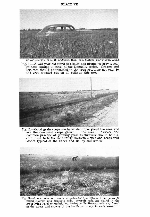
PLATE VII
(Photo ccurW.sy OI G. H. Andcrson, Dzm. Exp. Station, Beaverlodge, AK&)
Fig. l.-A two year old stand of alfalfa and brome on grey wood- ed soils similar to those of the Donnelly series. Grasses and legumes should be included in the trop rotations not only in the grey wooded but on a11 soils in this area.
Fig. 2.-Good grain crops are harvested throughout the area and are the dominant crops grown in the area. However, the common practice of growing grain exclusively should be dis- continued. Note the long fairly uniform slopes and occasional stones typical of the Esher and Belley soi1 series.
Fig. L-A one year old stand of creeping red fescue in an area of mixed Rycroft and Broncha soils. Rycroft soils are found in the lower lying level to undulating basins while Bronco soils are found on the slopes and crowns of the knolls or humps in such areas.

PLATE VIII
- Fig. l.-Water erosion, that was the result or the spring run-off
in 1948, in the Rycroft-Bronco mixed area northeast of Prest- ville. Maintaining the organic matter and farming across the slope Will help prevent this 10s~.
Fig. 2,Gully erosion on ‘Langent soi1 southwest of Eagleshaml This is again the result of the spring run-off of 1948. The slope is from one to two percent and the soi1 has a friable silty sub- soi1 in which gullies cari form rapidly. Unless steps are taken to build up the fibre and organic matter, increased losses from soi1 erosion cari be expected in this area.
Fig. 3.-Kakut lake in August 1945. Indiscriminate removal of tree caver has resulted in variable and generally diminishing supplies of water in most of the lakes and stream courses of the Rycroft and Watino sheets.
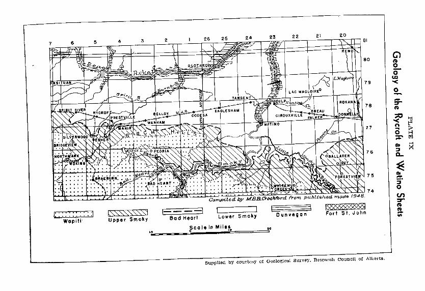
PLATE IX
Geology
of the R
ycroft and W
atino Sheets
r

,-
Soi1 Survey of Rycroft and Watino Sheets 45
are outlined on the basis of that dominante. While Falher soils are imperfectly or somewhat poorly drained they occupy better drained positions than those of Nampa soils, They are found in fairly open or sparsely wooded areas with level to undulating topography.
Falher soils have a dark brown to greyish brown A, horizon that is usually about 4 inches thick. The depth to the B horizon is generally quite variable but the break between the A and B horizons is very abrupt and very distinct. (See Plate V, Fig. 3.) They are degraded black soils and they usually have a well devel- oped solodized solonetz type of profile in which there are very few to no stones. The following is a generalized description of a profile typical of the Falher series:
Horizon 0.1 l-5
5-7
A,(B,) 7- 10
B2 10-17
BS 16 - 22
Bd 22 - 28
Bca 28 - 36
Bsor 36-
Depth in Inches
J Yc&%# .‘- c Description
Dark brown leaf litter. pH 7.5 to 7.7 Dark brown to dark greyish brown silt loam to clay loam, granular, loose. pH 6.2 to 6.7 Yellowish brown to light yellowish brown very fine sandy loam to silt loam, platy, fri- able. pH 5.2 to 5.5 Greyish brown silt loam to silty clay loam, vesicular, nuciform, fairly firm. Aggregates sometimes have a dark brown staining on the under sides. pH 5.3 to 5.8 Dark greyish brown to dark grey &y. Massive, very firm and has a waxy or glazed appearance when dry. pH 7.0 to 7.5. Dark greyish brown to dark grey clay. Mas- sive, vrey firm and has a waxy or glazed appearance when dry. pH 7.0 to 7.5 Dark grey to very dark grey clay, massive, firm. pH 7.4 to 7.8 Dark giey clay with occasional silty laminae. Lime low to medium-spotty. pH 7.9 to 8.1 $;I$X%? with gypsum accumulation. pH 8.0
Agricultural Use: Falher soils are good soils but they require careful management. Their loose surface soi1 is vulnerable to both wind and water erosion. The fibre content is not high and needs building up. In addition the tight subsoil absorbs water slowly, SO that during heavy rains the surface may become wet enough to flow. This condition is becoming increasingly apparent in some of the older settled areas neighboring Falher, Girouxville and Prestville. (See Plate VIII, Fig. 1.)
As in the Nampa soils, this tight subsoil offers physical obstruc- tion to root penetration. The incorporation of organic matter and the growing of deep rooted legumes Will help to improve the structure of these soils.

46 Bulletin No. 53
While there is usually a salt concentration layer in the lower part of the solum, alkali does not appear to be a problem in the management of these soils.
(c) Rycroft Series: (BIack silt loam to clay loam) Rycroft soils predominate in about 52,000 acres of the mapped
area. They are found in association with Falher and Nampa soils and, in the western portion, with Bronco soils. While their interna1 drainage is slow, they occupy the better drained positions of areas that have a slightly wavy, level to undulating topography. However, when associated with Bronco soils (north of Rycroft), they are found on the lower slopes of the knolls and in the level to undulat- ing areas between the knolls.
Rycroft soils are stone-free and have a darker colored solum than Landry soils. They are very similar to Falher soils except that they have a deeper A, horizon that is very dark brown to black in color. The following is a generalized description of a profile typical of the Rycroft series. It is a black soi1 having a solodized solonetz type of profile.
Depth Horizon in Inches Description
AI O-6 Very dark brown to black silt loam to silty clay loam, weakly prismatic, crushes readily to smala granular structure. pH 6.8 ta 7.0
AZ 6-7 Greyish brown to yellowish brown silt loam, platy, friable. This horizon is often absent. pH 6.2 to 6.4
A~I) 7-9 Yellowish brown clay loam to silty olay loam, vesicular, nuciform, fairly firm-often occur- ring in loose clusters. pH 6.3 to 6.6
B2 9- 18 Very dark greyish brown clay, columnar to massive, very firm, mediurn blocky meso- structure. pH 6.7 to 6.9
B, 18 - 24 Dark grey to very dark grey clay, massive, very firm. Has a waxy or glazed appearance when dry. pH 7.7 to 8.0
Bca 24 - 36 As above with occasional yellowish brown silty laminae. Lime low to medium-spotty. pH 8.0 to 8.4
Bsot 36 - As above with gypsum accumulation. pH 7.9 to 8.1
Agticultural Use: Rycroft soils are very good soils but their successful management involves the same considerations that were referred to in the discussion of Falher soils. For the most part a grain-summerfallow system has been followed on these soils since they were brought under cultivation twenty to thirty years ago. Many fields drift badly each fa11 and spring and water erosion is becoming a serious problem. Furthermore, yields have dropped appreciably-in many cases by as much as 50 percent. Rycroft soils are adaptable to a fairly wide range of crops and responsive to good mixed farming practices.
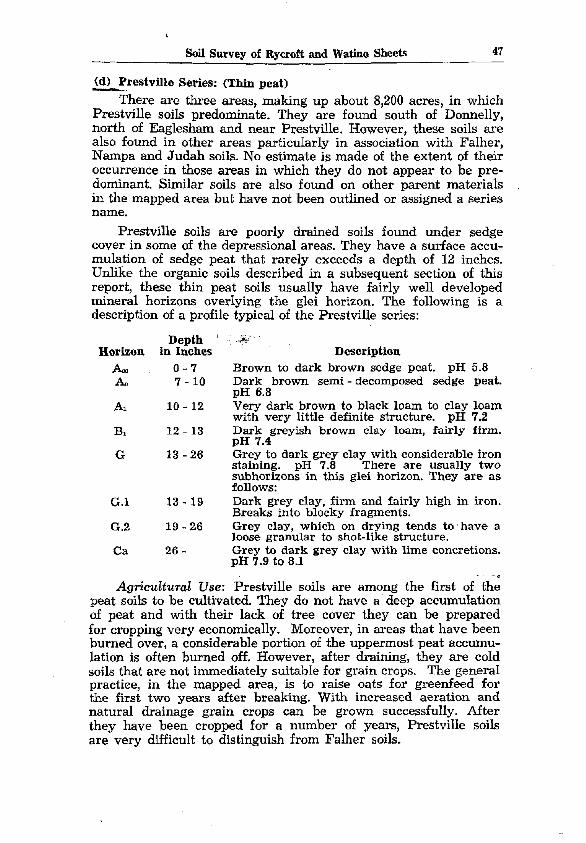
Soii Survey of Rycroft and Watino Sheets 47
(d) Ikh4lle Series: (Thon peat) -_. There are three areas, making up about 8,200 acres, in which
Prestville soils predominate. They are found south of Donnelly, north of Eaglesham and near Prestville. However, these soils are also found in other areas particularly in association with Falher, Nampa and Judah soils. No estimate is made of the extent of their occurrence in those areas in which they do not appear to be pre- dominant. Similar soils are also found on other parent materials in the mapped area but have not been outlined or assigned a series name.
Prestville soils are poorly drained soils found under sedge caver in some of the depressional areas. They have a surface accu- mulation of sedge peat that rarely exceeds a depth of 12 inches. Unlike the organic soils described in a subsequent section of this report, these thin peat soils usually have fairly well deveIoped minera1 horizons overlying the glei horizon. The following is a description of a profile typical of the Prestville series:
Horizon Depth ! . *+v
in Inches Description & o-7 Brown to dark brown sedge peat. pH 5.8 A0 7 - 10 Dark brown semi - decomposed sedge peat.
pH 6.8 AI 10 - 12 Very dark brown to black loam to clay loam
with very little definite structure. pH 7.2 B1 12 - 13 Dark greyish brown clay loam, fairly firm.
pH 7.4 G 13 - 26 Grey to dark grey clay with considerable iron
staining. pH 7.8 There are usually two subhorizons in this glei horizon. They are as follows:
G.l 13 - 19 Dark grey clay, firm and fairly high in iron. Breaks into blocky fragments.
G.2 19-26 Grey clay, which on drying tends to ‘bave a loose sranular to shot-like structure.
Ca 26 - Grey io dark grey elay with lime concretions. pH 7.9 to 8.1
Agrkulturctl Use: Prestville soils are among the first of the peat soils to be cultivated. They do not have a deep accumulation of peat and with their lack of tree caver they cari be prepared for cropping very economically. Moreover, in areas that have been burned over, a considerable portion of the uppermost peat accumu- lation is often burned off. However, after draining, they are cold soils that are not immediately suitable for grain crops. The general practice, in the mapped area, is to raise oats for greenfeed for the first two years after breaking. With increased aeration and natural drainage grain crops cari be grown successfully. After they have been cropped for a number of years, Prestville soils are very difficult to distinguish from Falher soils.

48 Bulletin Na. 53
D. Soils Developed on Alluvial-Lacustrine Deposited Material This material is found at elevations that are somewhat lower
than those of the lacustrine deposits. It adjoins the latter and occurs adjacent to the main drainage courses on what appear to be the uppermost river terraces. It consists of stratified silty clay that is brown to greyish brown in color. The strata are gener- ally thin and often contain yellowish brown layers of silt or very fine Sand. The underlying lacustrine or modified lacustrine mate- riais are found at variable depths and in some parts of the area are exposed at the surface.
While these brown silty clay areas usually have an undulat- ing to gently rolling topography they are often characterized by a humpy and dune-like topography in which the slopes are very irregular, quite variable and sometimes exceed 10 percent. Usually the slopes are short and from a distance the areas appear to be part of an undulating plain. In some of tlie knolls of such areas, strati- fication is much less apparent in the parent material and it may be that some of these silty clay deposits have been reworked and redeposited by wind.
The soils formed .on this material have a distinctive brown colored solum whose struct.ure is granular to nuciform and quite friable. They often occur in association with Rycroft, Falher and Nampa soils and with soils formed on similar but more variable parent material. In addition, thin peat and organic soils are com- monly found in many of the lower positions of these areas. Fol- lowing is a description of the dominant soils formed on this alluvial- lacustrine parent material:
(a) Judah Series: (Degraded black or brown forest silt loam to silty clay loam) Judah soils predominate in about 230,000 acres, largely in the
central and northern portions of the..mapped area. They are well drained soils and their topography is undulating to gently rolling and rolling. The native caver is a woodland vegetation in which aspen poplar is predominant.
Judah soils cari be recognized by the brown colored surface horizon and by a brown fairly heavy tegtured, usually stone-free subsoil. The structure of the solum iç fairly loose and the struc- tural aggregates lack the cohesion typical of Falher soils. Further- more, there is often a gradua1 greying of the lower part of the A horizon rather than any distinct A, horizon. With respect to their color and structure they are unlike other degraded black soils in thés area and more closely resemble brown forest soils. The following is a generalized description of a Judah soi1 profile:

Soi1 Survey of Rycroft and Watino Sheets 49
Horizon Depth
in Inches A0 o-1
AI .l-4
A, 4-6
B* 6- 12
B2 12 - 18
B3 18 - 24
Bca 24 - 36
c 36 -
Description Dark brown decomposed and semi-decomposed leaf litter. nH 7.3 to 7.6 Dark brown-to brown silt loam to silty clay loam, fine granular to crumb, friable. pH 6.9 to 7.2 Yellowish brown very fine sandy loam to silt loam, fine granular to crumb, friable. pH 6.5 to 6.8 Brown to dark yellowish brown silty clay loam to silty clay, granular to nuciform, fri- able. pH 5.8 to 6.2 Similar to above but somewhat more compact. pH 5.6 to 6.2 Dark yellowish brown silty clay loam to silty clay, nuciform, friable. Occassionally has light yellowish brown’ silty and very fine sandy laminae. pH 7.0 to 7.4 Brown to yellowish brown silty clay, nuci- form, friable, frequently laminated, usually fairly high in lime. pH 8.1 to 8.3 Greyish brown silty clay loam to silty clay, granular to nuciform? friable. Brownish yel- low laminae of very fine sand or silt are often present. pH 8.1
Ag&-uEturul Use: Depending on topography, Judah soils are fairly good to good arable soils. However, they are generally low in plant fibre and organic matter. In addition, water erosion- particularly gully erosion, is becoming increasingly troublesorne in many of these soils. Fibre and organic matter must be built up to increase the adhesion of the soi1 aggregates. Grasses should be included along with legumes in the trop rotations. The introduction of grass fibre, green manure and occasional applications of ferti- lizer appear to be the basic requirements for a successful manage- ment of Judah soils.
(h) Bronco Series: (Black silt loam to silty clay loam) In the western portion of the area, near Rycroft, there are
about 12,000 acres in which Bronco soils predominate. In addi- tion, they are of miner but nevertheless significant occurrence in some areas where Rycroft or Falher soils predominate. They have a “humpy” gently rolling to rolling topography in which the slopes are usually short and fairly steep. Bronco soils are found on the Upper well drained portions of the humps whereas Rycroft, Falher or Nampa soils are often found on the lower slopes and in the undulating area between the knolls.
Bronco soi1 profiles have a fairly thick, very dark brown to black A horizon underlain by a dark yellowish brown to brown, granular B horizon. They are well drained, stone-free soils devel- oped on a parent material that, in some cases, appears to have

50 Bulletin Na 53
been reworked and redeposited by wind. Following is a generalized description of a profile typical of the Bronco series:
Depth Horizon in Inches Description
A1 o-3 Black silt loam, slightly prismatic, weak crumb structure. pH 7.0 to 7.3
A3 3-8 Very dark grey to very dark greyish brown silty loam to silty clay loam, weakly prismatic, fine granular, friable. pH 6.4 to 6.8
Bl 8- 13 Dark yellowish brown silt Ioam to silty cIay loam, fine granular to nuciform, weakly pris- matic, friable. pH 6.2 to 6.5
B2 13-20 Dark yellowish brown to brown silt loam to silty clay loam. More compact and coarser nuciform than B1. pH 6.3 to 6.6
B, 20 - 24 Dark yeIlowish brown to dark greyish brown silty clay loam to silty clay, fine nuciform, friable. pH 6.7 to 7.0
Hca 24 - As above with moderate lime. pH 7.8 to 8.1
Agricult~wal Use: Bronco soils are very good agricultural soils and are adapted to a fairly wide range of crops. They are relatively rich soils on which good tilth cari be maintained fairly easily. How- ever, they are vulnerable to water erosion. Therefore, in addition to maintaining their fertility every effort must be made to main- tain their fibre and organic matter content. The periodic inclusion of grass and legume crops and the reduction of summerfallow are essential considerations in the proper management of these soils.
(cl Wanham Series: (Depression podsol) There are two areas near Wanham, comprising a total of about
15,000 acres, in which Wanham soils are predominant. In addition, however, they are found along with Nampa and organic soils in other poorly drained depressional portions of the Judah and Davis soi1 areas. The extent of their occurrence in such areas is very difficult to determine and appears to be governed by the depth and distribution of the brown silty clay parent material. Since this’ is often thin or absent in the depressional portions of these areas, there is usually an erratic distribution of both Wanham and Nampa soils.
The solum of a typical Wanham soi1 profile is light yellowish brown to greyish brown in color. Occasional rusty streaks or stains are common in both the surface and sub-surface horizons. However, the subsoil lacks the compactness and the dark color typical of Nampa soils. Following is a description of a profile typical of the Wanham series:

Soi1 Survey of Rycroft and Ylratino Sheets 51
Horizon A0 Al Aa
A22
As
B1
Bf
Bca
Depth in Inches
o-1 l-3 3-7
7- 11
Description Dark brown sedge and leaf debris. pH 7.5 Very dark brown to black, silty muck. pH 7.0 Light grey to grey very fine sandy loam, coarse platy, friable. pH 6.6 Light brownish grey very fine sandy loam, platy, with occasional iron stains and concretions. pH 5.2. Light yellowish brown silt loam, veshular, small nuciform, friable. pH 4.9 Grey silty clay, granular to nuciform with some iron staining, friable, pH 5.5 Grey to greyish brown clay, coarse nuciform, firm. pH 6.8 Grey and yellowish brown mottled silty clay. Has occasional iron streaks and is often lam- inated with very fine sand or silt. Moderate lime. pH 8.1
11- 15
15-24
24-30
30 -
AgriculturaE Use: Soils of the Wanham series are cold soils that are not immediately adapted to grain trop production. Im- proved drainage, aeration and the incorporation of organic matter are essential to successful trop production. Grasses, clovers and coarse grains are grown successfully and appear to respond favor- ably to periodic applications of fertihzer.
E. Soils Developed on Alluvial and Aeolian Deposited MateriaIs These deposits are part of the uppermost terrace deposits
associated with the Peace and Smoky rivers. They generally occur closer to the valleys of those drainage courses than do the more uniform silty clay deposits. They are stratified but the strata are generally thicker and consist of alternating beds of Sand, silt and clay. Some of the strata are cross bedded and it would appear that wind may have been at least partly responsible for sorting and redepositing some of this parent material.
A wide variety of soils is formed on this type of parent material. Most of them, however, may be grouped according to the dominant textural characteristics of their parent material. These groups are as follows:
1. Calcareous, Variable Silty Parent Material that has Occasional Sandy Strata This material is yellowish brown in color, fairly high in lime
and stratified. The strata are rarely less than 6 inches thick and vary considerably. For the most part, however, silt and silty clay strata predominate. The following are the dominant soils formed on this material:
(a) Davis Series: (Grey wooded loam to silt Ioam) Soils of this series predominate in about 175,000 acres of the
mapped area and often occur in association with Judah soils. They

52 Bulletin No. 53
are well drained soils with a humpy, gently rolling to rolling topography. The knolls are low but often steep-sided. The native caver is a woodland vegetation consisting of aspen poplar, spruce, shrubs and coarse grasses. Sedges, and sometimes mosses are found in many of the poorly drained depressional areas associated with this series.
While Davis soils are classified as grey wooded their profiles are usually much browner in color than those of other grey wooded soils. Often the darkest part of the solum is the lower part of the B horizon lying immediately above the lime horizon. In addition, thin strata that are reddish brown in color sometimes occur at varying intervals in the B horizon. However, Davis soi1 profiles are quite variable. There is little uniformity as regards the depth to the chfferent strata or as regards the thickness of the respective strata. A solum that is predominantly silty is characteristic of these soils. Following is a generalized description of a typical Davis soi1 profile:
Horizon
A0 A, A*
Depth in Inches
o-1 l-2 2-5
As 5-8
B, s- 20
B? 20 - 26
Bca 26 - 30
C 30 - 50
Description
Dark brown organic debris. pH 7.2 Brown loam to silt loam, often absent. pH 7.0 Light brown to very pale brown very fine sandy loam to silt loam, platy, very friable. nH 6.4 to 6.8 Pale brown silt loam to silty clay loam, vesi- cular, nuciform, friable. pH 6.2 to 6.6 Yellowish brown silt loam-to silty clay loam, weakly columnar, nuciform, friable. pH 5.4 to 5.8 Brown to strong brown silty clay. Somewhat more compact than the B1 horizon. pH 5.6 to 6.0 Light brownish grey silty clay and light yel- lowish brown silt and very fine sand strata that often exceed 12 inches in thickness. Fair- ly high to high lime. pH 8.0 to 8.6 Light yellowish brown very fine sand to silt loam in upper 8 inches. Remainder very fine sa:; to mit wrth occaaonal thm bands of s11ty
Agrkultural Use: Davis soils are fair to fairly good arable soils. They are loose, medium textured soils that are vulnerable to both wind and water erosion. In addition, they are generally fairly low in organic matter and in minera1 plant foods.
Grasses and legumes must be included in the trop rotations to build up the fibre and organic matter content of Davis soils. Experi- ence has shown that such grasses as crested wheat, creeping red fescue, slender wheat and brome cari be grown successfully, AI- falfa, sweet clover and altaswede are very desirable soi1 improv-

Soil Survey of Rycroft and Watino Sheets 53
ing crops and legume seed production has met with marked suc- cess in many of the Davis soi1 areas.
Since these soils tend to ‘have a low reserve of minera1 plant foods they may respond to fertilizer amendments. Present experi- mental evidence indicates a very marked response to phosphate fertilizers, and a lesser, but nevertheless significant, response to nitrogen fertilizers.
(b) Tangent Series: (Degraded black or brown forest silty loam to silty clay loam) Tangent soils predominate in about 20,000 acres of the mapped
area. They are found in association with Falher, Judah, Davis and Leith soils in locations that are characterized by a prevailing south slope, and by a sparser tree caver than that of Davis soils.
They have a well developed, dark colored A, horizon. Other- wise their profile is much the same as that of Davis soils. The prevailing brown color of the solum is unlike that of other degraded black soils and it is suggested that it might resemble that of brown forest soils. Following is a generalized description of a profile fairly typical of the Tangent series:
Depth Horizon in Inches Description
A1 O-3 Very dark brown to brown very fine sandy loam to silt loam with little definite structure. A thin A, horizon is often found above this horizon. pH 7.6 to 7.8
Az 3-5 Pale to very pale brown very fine sandy loam, weakly platy. pH 7.4 to 7.6
As 5-8 Light yellowish brown very fine sandy loam to silt loam, weakly platy to small granular, loose. pH 7.2 to 7.6
BI 8- 16 YeUowish brown to brown siIt loam to silty clay loam, weakly prismatic, weakly nuci- form, friable. Lower 2 to 3 inches often darker colored. pH 7.4 to 7.8
Bca 16 - 30 Grey to light brownish grey very fine sand to silt loam. Fairly high in lime-often marly. pH 8.6
C 30 - 50 As above and occasionally finely laminated or cross-bedded.
AgricuEtural Use: Tangent soils are fairly good to good arable soils but they are vulnerable to both wind and water erosion. Fibre is needed to bind the loose soi1 aggregates and to increase the water-holdmg capacity of these soils. It is essential therefore that the organic matter and fibre content be maintained at a fairly high level. Otherwise soi1 erosion cari become a serious problem. (See Plate VIII, Fig. 2.)
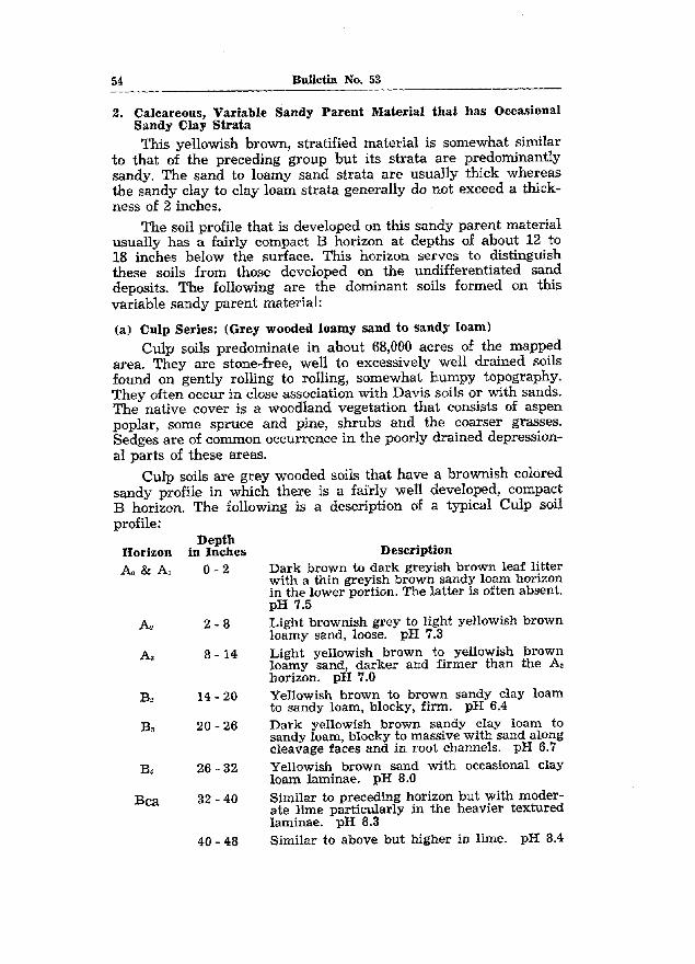
54 Bulletin No. 53
2. Calcareous, Variable Sandy Parent Material that has Occasional Sandy Clay Strata This yellowish brown, stratified material is somewhat similar
to that of the preceding group but its strata are predominantly sandy. The sand to loamy sand strata are usually thick whereas the sandy clay to clay loam strata generally do not exceed a thick- ness of 2 inches.
The soi1 profile that is developed on this sandy parent material usually has a fairly compact B horizon at depths of about 12 to 18 inches below the surface. This horizon serves to distinguish these soils from those developed on the undifferentiated Sand deposits. The following are the dominant soils formed on this variable sandy parent material:
(a) Culp Series: (Grey wooded loamy sand to sandy loam) Culp soils predominate in about 68,000 acres of the mapped
area. They are stone-free, well to excessively well drained soils found on gently rolling to rolling, somewhat humpy topography. They often occur in close association with Davis soils or with sands. The native caver is a woodland vegetation that consists of aspen poplar, some spruce and pine, shrubs and the coarser grasses. Sedges are of common occurrence in the poorly drained depression- a1 parts of these areas.
Culp soils are grey wooded soils that have a brownish colored sandy profile in which there is a faïrly well developed, compact B horizon. The following is a description of a typical Culp soi1 profile:
Horizon Ao & AI
A,
A3
BZ
BS
B1
Bca
Depth in Inches
o-2
2-8
8 - 14
14 - 20
20-26
26 - 32
32 - 40
40 - 48
Description Dark brown to dark greyish brown leaf litter with a thin greyish brown sandy loam horizon in the lower portion. The latter is often absent. pH 7.5 Light brownish grey to light yellowish brown loamy sand, loose. pH 7.3 Light yellowish brown to yellowish brown loamy Sand, darker and firmer than the AZ horizon. pH 7.0 Yellowish brown to brown sandy clay loam to sandy loam, blocky, firm. pH 6.4 Dark yellowish brown sandy clay loam to sandy loam, blocky to massive with sand along cleavage faces and in root channels. pH 6.7 Yellowish brown sand with occasional clay loam laminae. pH 8.0 Similar to preceding horizon but with moder- ate lime particularly in the heavier textured laminae. pH 8.3 Similar to above but higher in lime. pH 8.4
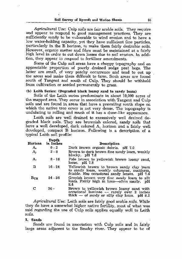
Soi1 Survey of Rycroft and Watino Sheets 55
Agricultural Use: Culp soils are fair arable soils. They require and appear to respond to good management practices. They are sufficiently sandy to be vulnerable to wind erosion and to have a low water-holding capacity, yet they have sufficient fine particles, particularly in the B horizon, to make them fairly desirable soils. However, organic matter and fibre must be maintained at a fairly high level in order to tut down losses due to soi1 erosion. In addi- tion, they appear to respond to fertilizer amendments.
Some of the Culp soi1 areas have a choppy topography and an appreciable proportion of poorly drained sedge peat bogs. The latter are small, of very patchy occurrence and tend to tut up the areas and make them difficult to farm. Such areas are found . south of Tangent and south of Culp. They should be withheld from cultivation or seeded permanently to grass.
(b) Leith Series: (Degraded black loamy Sand to sandy loam) Soils of the Leith series predominate in about 10,000 acres of
the mapped area. They occur in association with Tangent and Culp soils and are found in areas that have a prevailing south slope on which the native tree caver is not very dense. The topography is undulating to rolling and much of it has a dune-like appearance.
Leith soils are well drained to excessively well drained de- graded black soils. They are brownish colored, sandy soils that have a well developed, dark colored A, horizon and a fairly well developed, compact B horizon. Following is a description of a typical Leith soi1 profile:
Depth Horizon in Inches
A0 o-2 0 2-8
A2 8- 16
B 16 - 24
Bca 24 - 36
C 36 -
Agricultural Use:
Description Dark brown organic debris. pH 7.0 Brown to dark brown fine sandy loam, weakly blocky. pH 7.6 Pale brown to yellowish brown loamy Sand, loose. pH 7.8 Yellowish brown to brown sandy clay loam to sandy loam, weakly columnar, nuciform, friable. Has occasional sandy lenses. pH 7.6 Greyish brown. very fine sandy loam to silt F$rn. Fanly hrgh in lime-often marly. pH
Brown to yellowish brown loamy sand with occasional laminae - rarely over 2 inches thick - of sandy or silty clay loam. pH 8.2
Leith soils are fairly good arable soils. While they do have a somewhat higher native fertility, most of what was said regarding the use of Culp soils applies equally well to Leith soils. 3. Sands
Sands are found in association with Culp soils and in fairly large areas adjacent to the Smoky river. They appear to be of
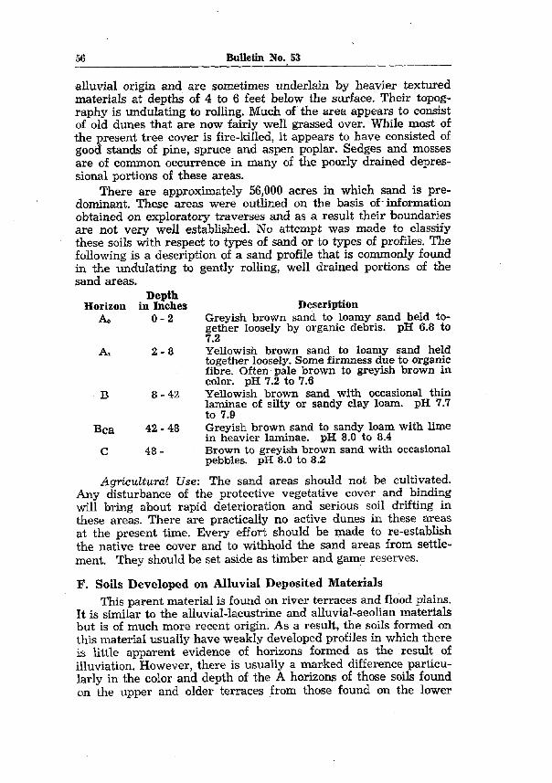
56 Bulletin No. 53
alluvial origin and are sometimes underlain by heavier textured materials at depths of 4 to 6 feet below the surface. Their topog- raphy is undulating to rolling. Much of the area appears to consist of old dunes that are now fairly well grassed over. While most of the present tree caver is fire-killed, it appears to have consisted of good stands of pine, spruce and aspen poplar. Sedges and mosses are of common occurrence in many of the poorly drained depres- sional portions of these areas.
There are approximately 56,000 acres in which sand is pre- dominant. These areas were outlined on the basis of- information obtained on exploratory traverses and as a result their houndaries are not very well established. No attempt was made to classify these soils with respect to types of Sand or to types of profiles. The following is a description of a sand profile that is commonly found in the undulating to gently rolling, well drained portions of the sand areas.
Depth Horizon in Inches Description
A0 o-2 Greyish brown sand to loamy sand held to- gether loosely by organic debris, pH 6.8 to 7.2
A, 2-8 YelIowish brown sand to loamy sand held together loosely. Some firmness due to organic fibre. Often pale brown to greyish brown in color. pH 7.2 to 7.6
B 8 - 42 YeGowish brown sand with occasional thin krx+rre of sI.lty or sandy clay loam. pH 7.7
Bca 42 - 48 Greyish brown sand to sandy loam with lime in heavier laminae. pH 8.0 to 8.4
C 48 - Brown to greyish brown sand with occasional pebbles. pH 8.0 to 8.2
Agricultural Use: The Sand areas should not be cultivated. Any disturbance of the protective vegetative caver and binding Will bring about rapid deterioration and serious soi1 drifting in these areas. There are practically no active dunes in these areas at the present time. Every effort should be made to re-establish the native tree caver and to withhold the Sand areas from settle- ment. They should be set aside as timber and game reserves.
F. Soils Developed on Alluvial Deposited Materials This parent material is found on river terraces and flood plains.
It is similar to the alluvial-lacustrine and alluvial-aeolian materials but is of much more recent origin. As a result, the soils formed on this material usually have weakly developed profiles in which there is little apparent evidence of horizons formed as the result of illuviation. However, there is usutilly a mar.ked difference particu- Marly in the color and depth of the A horizons of those soils found on the Upper and older terraces from those found on the lower
Soi1 Survey of Rycroft and Watino Sheets 57
terraces and more recent flood plains. The former are often darker colored as the result of having a greater accumulation of organic matter. The following are the soils formed on this more recent alluvial material:
(a) Spirit River Series: (Black sandy Ioam to silt loam) A small area of Spirit River soils (about 1,600 acres) is out-
lined just west of Rycroft. The area is stone-free and appears to be an upper terrace of the Spirit river. It has a very gently sloping, smooth topography. The native caver appears to have been a fairly open parkland in which grasses were predominant.
Spirit River soils are well drained black soils that have a weakly developed soi1 profile. The A horizon is usually fairly thick and very dark brown to black in color. The brownish colored B horizon has little. definite structure and consists of a sequence of depositional strata. The texture usually varies from hght loam to silt loam and depends on the depth and nature of the various strata. Following is a description of a profile typical of the Spirit River series: -
Depth Horizon in Inches
AL O-6 Description
Very dark brown to black loam to silt loam, weakly granular. Some firmness largely due to organic fibre. pH 7.2 Brown to yellowish brown deposited strata that have very little definite structure but do have some evidence of leaching and accumu- lation. pH 6.8
B 6-30
6-10 10-20
20-22 22 - 30
&a 30-
The following are typical of these strata: Brown to yellowish brown loam to silt loam. Yellowish brown very fine sandy loam to silt Ioam. Light yellowish brown loamy Sand. Brown to yellowish brown clay Ioam-weakly nuciform. Yellowish brown silt loam-low to moderate lime content. pH 8.1
Agricultural Use: Spirit River soils are very good soils that have a fairly high native fertihty. However, they have been culti- vated for a long time and may have been some of the first soils farmed in the surveyed area. Their fibre content is low and soi1 drifting is becoming a problem. Thus, rotations that include grasses and legumes should replace the present continuous wheat-fallow rotations.
(b) Alluvimn Alluvium refers to material, deposited by rivers, that occurs
on the terraces and flood plains in the valleys of those rivers. This material is of fairly recent origin and has variable characteristics. Consequently a wide variety of immature soils is found in these

58 Bulletin No. 53
valleys. The soils are greyish brown to dark brown in color and vary in texture from a fine sandy loam to a silt loam. The subsoils are often sandy ,and sometimes gravelly. These flats are variable in size and often badly tut up by oxbows and old stream courses. They are found mainly in the valleys of the Peace and Smoky rivers and the largest OCCUP in the vicinity of Watino. In ail, about 12,000 acres of such river flat and bench lands are outlined on the soi1 map.
Darker colored, often more mature soils are found on the higher and older benches. The following is a description of a profile found on one of the Upper benches of the Smoky river flat near Watino.
Depth Horizon in Inches Description
A O-8 Black grading to dark brown? silt loam to very fine sandy loam, weakly nuctiorm. Some firm- ness largely due to organic fibre. pH 6.8
B 8 - 24 Brown to yellowish brown silt and very fine sand strata. pH 5.7
24- Gravel.
AgricuEtural Use: Soils formed on recent river deposits are usually fairly good to good arable soils. However, they are often excessively well drained soils and tend to be droughty. It would appear that the organic matter content of these soils should be built up and maintained at a fairly high level. At the present time much of this land is being used for the growing of cereal grains and hay crops.
G. Soils Developed on Coarse Outwash Materials These materials are coarse textured and often quite gravelly
or stony. They are found as islands of varying size associated with the till areas or along some of the lower slopes of these areas. The large& of these islands are outlined in the eastern part of the mapped area. The soils formed on this material are coarse textured and quite variable. The surface is usually a sandy loam that may be gravelly or stony. The subsoil may contain thick grave1 lenses or may be a deep deposit of grave1 and cobble stones.
(a) Clouston Series: (Grey wooded gravelly or stony loamy sax sandy loam) There are about 7,500 acres of Clouston soils in the mapped
area. They are found on undulating to gently rolling bench lands and sometimes on slight ridges or <knolls. The largest of these areas are outlined on the soi1 map. Occasional small areas also occur in association with Braeburn and Donnelly soils. Clouston soils are gravelly and stony soils that have a leached profile similar to that of grey wooded soils. They are excessively drained, coarse textured soils that often have a lime accumulation horizon at depths of about 48 inches.

Soi1 Survey of Rycroft and Watino Sheets 59
Agriculturul Use: Soils with gravelly subsoils are droughty since they have a low water-holding capacity. They also have a low fertility reserve. Unless the grave1 and stone accumulation occurs at depths greater than 12 inches below the surface such soils are not suited for trop production. If the grave1 is deeper and the topography suitable they may be. fair arable lands. There are some grave1 pits in the Clouston soi1 areae but they do not appear to be of commercial importance.
H. Soils Developed on Relatively Thin Alluvial Deposits that Overlie Other Heavier Textured Deposits The parent material of this group of soils consists of somewhat
sandy material overlying other heavier textured material. The variable, sandy deposits are generally shallow and rarely exceed a depth of about 30 inches. Most frequently they are about 12 to 18 inches thick. They occur on many of the lower slopes of the till areas or on the uplands adjoining some of the drainage courses. Thus they may be either shallow beach or flood plain deposits. The underlying heavier textured material may be till, stratified till or lacustrine material. The sandy deposits that are somewhat gravelly and often stony are most frequently underlain by till, whereas the more uniform, often stone-free, deposits are usually underlain by lacustrine material. Accordingly the soils formed on this overlying material are grouped as follows:
1. Fairly Uniform Sandy or Silty Material Overlying Lacustrine or Stratified Till Deposits These shallow alluvial deposits are found south of Codesa,
west of Peoria, and west of Rycroft. They may be the result of a flooding over of the adjacent stream courses.
(a) Peoria Series: (Degraded black to black sandy loam to silt Ioam) Peoria soils predominate in about 15,000 acres of the mapped
area. They are very similar to Spirit River soils except that at depths of up to about 30 inches they are underlain by dark grey or dark greyish brown clay. This depth is quite variable however and in some areas Falher and Rycroft soils are associated with or may predominate over Peoria soils.
They are well drained to poorly drained soils depending on position and on the depth of the overlying material. They have a level to undulating topography and are found in areas character- ized by a fairly open woodland or parkland vegetation. Peoria soils are degraded black to black soils. The Upper part of their A horizon is dark brown to black in color while the lower part is usually yellowish brown in color and often weakly platy. Like Spirit River soils they do not have a very well developed profile. The following is a description of a profile typical of the Peoria sesies: i’ ~+~&
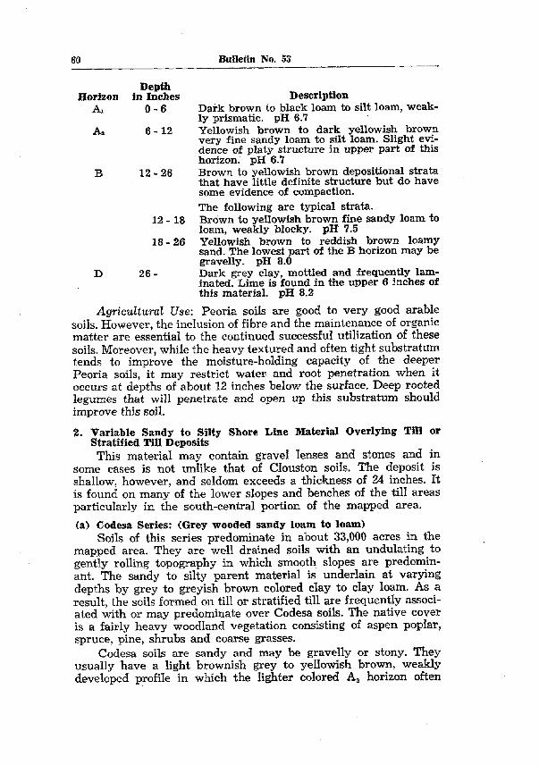
Description
60 Bulletin No. 53
Depth Horizon in Inohes
A, O-6
Aa 6 - 12
B 12 - 26
Dark brown to black loam to silt loam, weak- ly prismatic. nH 6.7 Yellowish brown to dark yellowish brown very fine sandy loam to silt loam. Slight evi- dence of platy structure in Upper part of this horizon. pH 6.7 -- -._ Brown to yellowish brown depositional strata that have little definite structure but do have
12 - 16
18-26
some evidence of compaction. The following are typical strata. Brown to yellowish brown fine sandy loam to loam, weakly blocky. pl3 7.5 Yellowish brown to reddish brown loamy sand. The lowest part of the B horizon may be gravelly. pH 8.0
D 26 - Dark grey clay, mottled and frequently lam- inated. Lime is found in the Upper 6 inches of this material. pH 8.2
Agricultural Use: Peoria soils are good to very good arable soils. However, the inclusion of fibre and the maintenance of organic matter are essential to the continued successful utilization of these soils. Moreover, while the heavy textured and often tight substratum tends to improve the moisture-holding capacity of the deeper Peoria soils, it may restrict water and root penetration when it occurs at depths of about 12 inches below the surface. Deep rooted legumes that will penetrate and open up this substratum should improve this soil.
2. Variable Sandy to Silty Shore Line Material Overlying Till or Stratified Till Deposits
This material may contain grave1 lenses and stones and in some cases is not unlike that of Clouston soils. The deposit is shallow, however, and seldom exceeds a thickness of 24 inches. It is found on many of the lower slopes and benches of the till areas particularly in the south-central portion of the mapped area.
(a) Codesa Series: (Grey wooded sandy loam to loam) Soils of this series predominate in about 33,000 acres in the
mapped area. They are well drained soils with an undulating to gently rolling topography in which smooth slopes are predomin- ant. The sandy to silty parent material is underlain at varying depths by grey to greyish brown colored clay to clay loam. As a result, the soils formed on till or stratified till are, frequently associ- ated with or may predominate over Codesa soils. The native caver is a fairly heavy woodland vegetation consisting of aspen poplar, spruce, pine, shrubs and coarse grasses.
.
Codesa soils are sandy and may be gravelly or stony. They usually have a light brownish grey to yellowish brown, weakly developed profile in which the lighter colored A, horizon often

Soil Survey of Rycroft and Watino Sbeets 61
has a platy or weakly platy structure. In the lower part of the profile there is often a gravelly lens at the contact with the under- lying heavier textured material. Following is a description of a profile typical of the Codesa series:
Depth Horizon in Inches
A0 o-2 Al 2-4
AP 4-8
B 8-16
D 16 -
Description Dark brown to black organic debris. pH 7.6 Light brownish grey loam to sandy loam hav- ing some firmness. Often absent. pH 7.4 Light yellowish brown fine sandy loam to loamy Sand, coarse platy to weakly platy. pH 5.7 Yellowish brown sandy loam to loamy Sand, very little definite structure, occasionally stratified and some evidence of compaction. Grave1 lenses and stones of common occur- rence. pH 5.6 Dark greyish brown to brown stratified till or till in which lime is found at depths of 30 to 36 inches below the surface. pH 7.0
Agricultud Use: Areas of Codesa soils range from non-arable to fairly good arable lands depending on the nature of the Upper parent material. Those which are predominantly gravelly or quite stony should not be cultivated. Codesa soils are fairly loose and tend to have a low fertility reserve. They are vulnerable to both wind and water erosion. Grasses and legumes will help to bind the loose soi1 aggregates. The heavy textured and often compact under- lying material is usually bettersupplied with the required minera1 plant foods than the sandier Upper deposit. Deep rooted legumes Will help to open up this compact substratum and Will replenish the supply of plant foods in the Upper deposit. Supplementary apph- cations of fertilizer may also prove beneficial in establishing a mixed farming agriculture on these soils.
(b) Belley Series: (Degraded black to black sandy loam to siIt loam) Belloy soils predominate in about 75,000 acres, chiefly in the
western half of the mapped area. They are very similar to Codesa soils except that they have a thicker and darker colored A, horizon. The native caver is a fairly open woodland or parkland vegetation.
Belley soils are generally more variable than Peoria soils and have variable gravelly lenses and stones. In this area they are usually formed on deposits that are somewhat shallower than those of Peoria soils. The depth to the underlying heavier textured deposits is quite variable with the result that Landry and Esher soils, or in some areas, Kavanagh soils are frequently associated with or may predominate over Belley soils. They are degraded black to black soils in which the Upper part of the profile is brown to black in color while the lower part is yellowish brown in color and often platy. There is usually a gravelly or stony lens at the
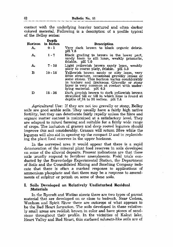
62 Bulletin No. 53
contact with the underlying heavier textured and often darker colored material. Following is a description of a profile typical of the Belley series:
Depth Horizon in Inches
A0 o-1
A* l-7
A, 7 - 10
B 10 - 18
D 18-36
Description Very dark brown to black organic debris. pH 7.8 Black grading to brown in the lower part, sandy loam to silt loam, weakly prismatic, friable. pH 7.0 Light yellowish brown sandy loam, weakly platy to coarse platy, friable. pH 5.8 Yellowish brown sandy or silty loam, very little structure, occasional gravelly lenses or some stones. This horizon varies considerably in texture and thickness. Gravelly or stony layer is very common at contact with under- lying material. pH 6.3 Dark greyish brown to dark yellowish brown stratified till or till in which lime is found at depths of;,24 to 30 inches. pH 7.4
Agrkuitural Use: If they are not too gravelly or stony, Belley soils are good arable soils. They usually have a fairly high native fertility, but they cari deteriorate fairly rapidly unless the fibre and organic matter content is maintained at a satisfactory level. They are adapted to mixed farming and suitable for a fairly wide range of crops. The inclusion of grasses and deep rooted legumes should improve this soi1 considerably. Grasses Will return fibre while the legumes Will also aid in opening up the compact D and in replenish- ing the plant food reserves in the Upper horizons.
In the surveyed area it would appear that there is a rapid deterioration of the minera1 plant food reserves in soils developed on some of the alluvial deposits. Present indications are that these soils usually respond to fertilizer amendments. Field triais con- ducted by the Beaverlodge Experimental Station, the Department of Soils and the Consolidated Mining and Smelting Company indi- cate that there is often a marked response to applications of ammonium phosphate and that there may be a response to amend- ments of sulphur or potash on some of these soils.
1. Soils Developed on Relatively Undisturbed Residual Materials In the Rycroft and Watino sheets there are two types of parent
material that are developed on or close to bedrock. Near Codesa, Wanh.am and Spirit River there are outcrops of what appears to be the Bad Heart formation. The soils developed in these relative- ly small areas are reddish brown in color and have pieces of sand- stone throughout their profile. In the vicinities of Ka6kut lake, Heart Valley and Bad Heart, thin surfaced solonetz-like soils are of

Soi1 Survey of Rycroft and Watino.Sbeets 63
common occurrence. They appear to be closely underlain by saline sandy shale and resemble similar soils that are formed on such material in other parts of the province. No exposures of this bedrock were found within a few feet of the surface, but the nature of the parent material would seem to justify the assumption that bedrock is relatively close and that it has exerted a major influence in the development of that parent material.
1. Reddish Brown Sandstone This material is-found very near the surface and caps the north
slopes of the slight elevations that are found just south of Codesa, Wanham and Spirit River. It is brick red in color and has a striking appearance in exposed road cuts.
(a) Rahab Series: (Sandy loam to loam, lithosol) There are about 1,400 acres in which Rahab soils predomin-
ate. They are developed on or in very close association with the underlying reddish brown sandstone. Rahab soils have a reddish brown to dark reddish brown surface horizon that is from 2 to 6 inches thick. The subsoil consists of a variable mixture of weathered bedrock material and fragments of sandstone. Areas of Rahab soils are small and frequently difficult to separate on this scale of mapping.
Agrkdtural Use: Rahab soils are often quite shallow and their parent material is relatively impervious to both water and root penetration. They are inferior agricultural soils and the shallower members should not be cultivated.
2. Saline, Sandy Shale In the mapped area there are thin surfaced solonetz-like soils ’
developed on shallow till deposits that are closely underlain by parent rock. These till deposits are usually strongly cemented and contain a high proportion of saline sandy shale material that appears to be derived from the underlying Wapiti formation.
(a) Kavanagh Series: (Degraded black to black loam to heavy loam) Kavanagh soils predominate in about 7,200 acres in the south-
western part of the mapped area. They usually occur in relatively small areas either alone or in association with some of the Brae- burn, Saddle, and Esher soils. In the vicinity of Heart Valley they are found in association with Belley soils and their parent material may form the D horizon of some of these soils. Kavanagh soils are found on depressional to gently rolling topography usually on or at the base of long smooth slopes. The native caver consists of scrub poplar, willow and the coarser grasses including some of the Salt resistant varieties.
Kavanagh soils are poorly drained. They have a thin dark grey- ish brown to blaok surface layer and a subsoil that is strongly cemented and relatively impervious to both root and water pene-

64 Bulletin No. 53
tration. While there is usually a fairly heavy concentration of salts in the lower part of the B horizon there appears to be very little lateral movement of these salts. Soils with excessive surface salt concentrations or Salt trusts do not occur in association with Kavanagh soils.
The following is a generalized description of a profile typical of the Kavanagh series. It appears to be a solonetz-like profile that has some of the characteristics of a solodized solonetz and some of a podsolized profile. A similar profile is typjcal of soils developed primarily on Edmonton parent rock and found in the vicinity of Kavanagh. They are described in the report titled “Soi1 Survey of Peace Hills Sheet.”
Depth Horizon in Inches
AI o-4
AP 4-6
BS 6 - 10
B3 10 - 22
Bca 22 - 28
Description Greyish brown to very dark brown loam to clay loam. Very little structure. Often over- lain with an A, horizon. pH 5.0 to 6.0 Light yellowish brown sandy loam, vesicular, coarse platy, tending to nuciform. pH 5.3 to 6.3 Dark greyish brown to very dark grey clay loam, very firm to indurated round topped columns, blocky mesostructure. pH 4.8 to 5.8 Greyish brown to dark greyish brown clay loam, massive, blocky to nuciform meso- structure. pH 6.3 to 7.3 Greyish brown to dark greyish brown clay loam to loam. Occasional sandy streaks, high in salts. pH 7.3
The whole profile has occasional stones and except for the A horizons it is very firm when dry.
Agricultural Use: Kavanagh soib are inferior agricultural soils. Their very firm, dark colored subsurface layer is relatively impervious to both water and root penetration. TO cultivate them with any degree of satisfaction, this hard layer must be opened up either by occasional deep plowing or by growing deep rooted crops. The former method does not appear satisfactory since the power required for deep plowing tends to make the operation too. costly. On the other hand, such crops as sweet clover cari be grown to very good advantage. Their long tap roots tend to penetrate the hard layer and facilit&e drainage and aeration. The addition of green manure and the gradua1 mixing in of the surface soi1 Will in time improve the structure of this undesirable subsoil. Until then, however, it is poor to fair arable land, whose undesirable characteristics are most apparent following heavy rains and during prolonged dry spells.
J. Organic Soils Organic soils are found in low poorly draïned areas. They
occur in patches of varying size associated with practically all of

Soi1 Surves of Rycroft and Watino Sheets 65
the soi1 series mapped in this area. They are particularly prevalent in the Falher, Judah, Davis and Culp soi1 areas and they occur extensively in some of the sand areas. The native caver consists of sedges and other moisture-loving coarse grasses, mosses, and in some of the larger areas variable stands of willow, spruce and tamarack.
Organic soils have an accumulation of organic matter that usually exceeds a thickness of 12 inches. The organic matter may be derived mainly from the partial decomposition of sedges and grasses or of mosses. For the purposes of this report organic soils are classified as sedge peat or moss peat soils depending on the dominant characteristics of the organic accumulation. No attempt was made to separate them on the basis of the characteristics of the D horizon.
(a) Eaglesham Series: (Sedge peat) There are approximately 76,000 acres of Eaglesham soils in
the many scattered and usually smalI areas outlined on the soi1 map. No estimate is made of the extent of their occurrence in the numerous low spots that are too small to outline on this scale of mapping. However, their relative distribution, in areas in which they are of significant occurrence, is indicated by means of map symbols. They are associated, to a variable extent, with most of the soils of this area.
The organic material of Eaglesham soils consists entirely or predominantly of sedge peat which, in this area, seldom exceeds a thickness of 30 inches. There is a considerable variation, however, in the thickness of the peat and in the nature of the underlying material. The following is a description of a profile typical of the Eaglesham series:
Dépth Horizon in Inches Description
1. O-16 Dark brown to brown partially decomposed sedge and rush remains. pH 5.8
2. 16 - 18 Dark brown to black fairly well decomposed sedge and rush remains. pH 6.8
3. 18-20 Black, well decomposed muck in which there are few recognizable leaf and stem remains. pH 7.3
4. (Dl 20-28 Light brownish grey to grey clay, fine granu- * lar, numerous rusty stains or streaks. pH 7.8
5. (Ca) 28 - 36 Grey to dark grey clay, fine granular, moder- ate lime. Rusty stains or streaks are found in the Upper 4 inches. pH 7.9
This profile is found on heavy textured lacustrine deposited material. Similar profiles are also found on the other materials described in the preceding portion of this report. For example, the following is a description of an Eaglesham profile found on light textured alluvial material in the area southeast of Eaglesham:

66 Bulletin No. 53
Depth Horizon in Inches Description
1. 0- 16 Brown to very dark brown sedge peat. pH 6.6 2. 16 - 24 Very dark brown sandy muck. pH 5.8
3. (D) 24 - 36 Light yellowish brown fine Sand. pH 5.6 4. (Dl 36 - 42 Grey to dark grey sandy clay loam -iron
stained, firm. pH 7.9 5. (Ca) 42 - 48 Similar to above horizon but has occasional
bands of sand and is moderately high in lime. pH 8.3
Agricdturcd Use: In wooded areas the shallower Eaglesham soils are among the first soils to be cultivated, particularly if they occur in areas of sufficient size to be farmed. Usually tree growth is not an impediment to cultivation and the only requirement is often that of trenching to provide drainage. However, they are cold soils on which oats are often grown for green feed during the first few years of cultivation. When they become opened up and their drainage is sufficiently improved, coarse grains cari be grown successfully. In many portions of the Falher soi1 areas it is very difficult to distinguish old peat soils from the better drained soils after prolonged cultivation.
The deeper Eaglesham soiIs in which the organic accumula- tion exceeds a thickness of about 30 inches, should not generally be cultivated. They are often quite wet and, while the depth of organic material cari be reduced by draining and burning such areas, they should not be disturbed since they may be of value in maintaining ground water supplies. Areas of such soils are found adjoining Lac Magliore, Kakut lake and in what is locally known as Egg lake, south of Eaglesham. Other areas are found south of Donnelly and in small patches elsewhere in the mapped area. In many cases, portions of these areas are being cultivated at the present time but this practice should be discontinued. The community cari il1 afford the loss of at least the larger of its natural water reservoirs.
(b) Kenzie Series: (Mass peat “muskeg”) Soils of this series are of relatively infrequent occurrence in
this area. They have an accumulation of moss peat and areas of these soils are commonly referred to as “muskegs.” The larger of such areas are outlined and make up a total of approximately 10,000 acres in the mapped area. In addition, numerous small areas are indicated but not outlined in parts of the southern ahd eastern portions of the area. Kenzie soils are found in poorly drained depressional areas in which the native caver consists of. sphagnum moss and ledum shrub, occassional sedges, and variable stands of spruce, tamarack, birch and willow.
The organic material of Kenzie soils is usually much coarser and woodier than that of Eaglesham soils. It consists of mossl peat or a mixture of moss and sedge peat in which the moss peat is

Soi1 Survey of Rycroft and Watino Sheets 67
predominant. In this area the organic accumulation rarely exceeds a thickness of about 30 inches. The following is description of a profile typical of the Kenzie series:
Depth Horizon in Inches Description 1. O-8 Dark brown to brown moss and moss peat that
is usually coarse and Woody and often con- tains tree root and stem remains. pH 4.7
2. 8- 13 Strong brown to dark yellowish brown peat containing recognizable remains of mosses and tree roots. OccasionaI thin, darker colored bands of sedge peat are common. pH 4.3
3. 13 - 19 Dark brown to verv dark brown fairlv well decomposed peat that often contains recogniz- able stems and Woody remains. pH 4.8
4. (Dl 19 - 28 Light yellowish brown to light brownish grey fine sandy loam, coarse blocky, very firm, occasional rusty streaks. pH 6.8
5. (Dl 28 - 34 Grey and light ,brownish grey clay, coarse nuciform, firm., granular mesostructure. Con- tains rusty stams or streaks. pH 7.0
6. (Dl 34-40 9zeyish brown clay, fine granular, firm. pH -1 .L
The thickness of the organic accumulation is quite variable and in areas adjoining the mapped area it often exceeds 36 inches. Similarly the underlying material may differ appreciably from that described. Kenzie soils are found on most of the parent mate- rials described in the preceding part of this report.
Agricultural Use: Kenzie soils are inferior agricultural soils. The peat is not usually in an advanced stage of decomposition and it would require a considerable time after drainage before these soils are in a proper condition for seeding. Most of the Kenzie soi1 areas are not being cultivated at the present time. It would appear most desirable from the standpoint of moisture conservation that at least the larger of these areas be protected and permanently with- held from cultivation.
DESCRIPTION OF MAPPED AREAS
The mapped areas are designated usually by two series names. In each case the first named series is believed to be predominant while the second named series is the most significant of the associ- ated soils in each mapped area. Reference then to the series descrip- tions Will enable the reader to familiarize himself with the domin- ant characteristics of each outlined area. However, the use of only two series names in the designation is not sufficient to denote the range of variability in various soi1 areas. In many cases, soils form- ing but minor percentages of the mapped areas are nevertheless of significant occurrence and in small local areas that do not appear on the soi1 map they may be predominant. Since the soils
68 Bulletin Mn. 53
are quite variable in this area, and since it has not been possible to outline small areas or adequately indicate the range of varia- bility on this scale of mapping, the following brief descriptions of some of the mapped areas may be helpful in interpreting the accompanying soi1 map.
Throughout the mapped area soils that are formed on the same type of parent material but differ in the color of their surface horizons, often occur in very close association with each other. This may be due to differences in the direction of slope or in micro-relief. In such cases it is not possible to outline each separ- ate soi1 series on this scale of mapping, but an attempt is made to outline the darker colored areas from the lighter colored greyer ones and to indicate this difference by differing combinations of series names. For example, near Falher, various areas are out- Iined . and designated as FaIher-Rycroft, Falher-Nampa, Nampa- Falher or Falher-Prestville. In these areas a11 four of the soi1 series developed on lacustrine parent material may occur, but the two selected indicate the dominant characteristics of each outlined area. Thus Falher-Rycroft are darker colored areas than the Falher-Nampa areas, but not as dark as the Rycroft-Falher areas. The Nampa-Falher areas are depressional and quite grey, while the Falher-Prestville are also somewhat depressional, but the low areas have an appreciable proportion of thin peat soils. Usually the first named series forms over 50 percent of the area while the second named makes up from 25 to 50 percent of the area. Similar considerations form the basis of separating other soi1 areas in which the soils are developed on the same type of parent material. In no case does the use of just the two series names imply the absence of soils other than those indicated in the designation.
In a large proportion of the mapped area soils developed on different types of parent material are found in close association with each other. Such soils are difficult to separate and the soi1 areas are difficult to designate in such a way as to indicate the range of variability in both color and parent material. In the Braeburn-Donnelly and Donnelly-Braeburn soi1 areas? for example, the predominant soils are designated in the order of their occur- rence in each of these areas. However, minor proportions of Saddle and Esher soils may occur and quite often Codesa and Clouston soils are found in association with these soils. The latter may occur in small patches and may predominate in some parts of these areas. While the larger areas are outlined, the numerous small patches could not be shown on this soi1 map. Similarly only the larger areas of organic soils are outhned or indicated. T~US a DonnellyiBraeburn soi1 area consists of both Donnelly and Brae- burn soils, with the former usually predominant, and it may include some Esher, Saddle, Codesa, Clouston, depression podsol and organic soils.

Soi1 Survey of Rycroft and Watino Sheets 69
The depth and distribution of the alluvial deposited materials is very variable in this area. In many of the Peoria, Belloy and Codesa soi1 areas the underlying heavier textured material may be found within about 18 inches of the surface. It may therefore affect the growth and development of crops in such areas. Thus in most cases the second series name selected for those areas is that of the soi1 developed on the heavier material even though it may not occur to a sufficient extent to be included as part of the designation of that area. A Belloy-Esher soi1 area, for example, would consist of Belloy soils underlain at varying depths by modi- fied lacustrine material. It would include an appreciable proportion of Esher soils but these would not necessarily occur to a greater extent than Codesa, Eaglesham or other related soils. In many of the Bronco, Judah, Davis and Culp soi1 areas however, the underlying, often heavier textured material is usually much deeper in a11 except some of the lower lying portions and in the fringe portions of these areas. In the low-lying portions both Wanham and Nampa soils are of common occurrence either alone or in association with each other. Thus, the Judah-Nampa soi1 areas have many depressional portions in which Nampa soils are often found. Bowever, Wanham soils, thin organic and organic soils may be just as common in these-portions but they are more closely related to Judah soils, and their occurrence may be less significant agri- culturally, than that of Nampa soils.
Some of the large poorly drained portions of these areas are difficult to designate adequately. The Nampa-Judah area north of Tangent is one which has Nampa, Judah, Wanham, Prestville, Davis, Eaglesham and Kenzie soils. The area may have been origin- ally a large bog in which islands of Judah and Davis soils were common. Much of the peat has been burned off and drainage has been improved with the result that soils not unlike Nampa soils prevail in the low flat portions of this area, while on the better drained islands Judah soils are predominant. The larger areas of organic soils are qutlined or indicated in those portions where they are of significant occurrence. The distribution of organic soils in this and the neighboring Davis-Judah soi1 areas was determined largely from aerial photographs since these areas were relatively inaccessible at the time of survey. The Wanham- Nampa - Judah soi1 area extending from near Wanham to just beyond Codesa consists of a mixture of soils found in a low-lying area fringing the heavier textured soi1 areas to the south. The alluvial deposition in this area is often shallow and while Wanham, Nampa and Judah soils are most common, Falher soils are found in some of the better drained positions and their heavier textured parent material may underlie the thin phase Judah soils in this area. In otber fringe areas the occurrence of Bronco and Judah soils is confined to the better drained humps or knolls of such areas. Near Rycroft, Bronco soils often occur on isolated knolls scattered throughout an other-
70 Bulletin No. 53
wise level to undulating area. Falher or Rycroft soils are found on the lower slopes and level areas adjacent to these knolls. Thus depending on the relative proportions of each, such areas are designated as Rycroft-Bronco, Falher-Bronco or Bronco-Falher. They may and often do include varying but usually minor pro- portions of Nampa, Wanham and Judah soils.
In addition to designating each soi1 area by a series name or by a combination of series names to indicate the dominant char- acteristics of that area, other supplementary characteristics are indicated on the soi1 map. The topography phase of each soi1 area is indicated by means of hatchuring. The various topography phases are indicated on the map according to the separations referred to in the map legend and described in a previous section of this report.
The steeply sloping and rough land bordering the stream courses is mapped as Eroded Land. About 218,000 acres of such land are found adjacent to the drainage courses and in the many deep coulees that are characteristic of much of this area. Eroded land is of value as pasture and woodland and as such it serves a very useful purpose. Overgrazing, indiscriminate removal of tree caver or cultivation should not be permitted in such areas. River banks that are devoid of tree caver lose their snow very rapidly with the result that many of the stream courses flood in the spring but are practically dry by midsummer. (See Plate III, Fig. 2.) In addition to the topography phases, other features that are impor- tant from the standpoint of land use, are indicated wherever possi- ble. For example, the excessively stony area south west of Wanham is designated as Codesa-Braeburn stony phase.
The dominant characteristics of each mapped area Will be apparent if the reader refers to the description of the designated soi1 series and notes whatever other features are indicated in the area under consideration. The information is not presented in sufficient detail, however, to show the variations that may exist in individual farm units. It cannot therefore be used as the sole basis in determining the value of farm units for sale or assessment purposes.
SOIL RATING
In describing the soils of the Rycroft and Watino sheets refer- ence has been made to a comparative rating as regards their native productivity. This rating is based on a consideration of such factors as the type of soi1 profile, degree of stoniness, and topography. The effect of these factors is considered in establishing a productivity grouping. This grouping is based on the past performance of some- what similar soils under existing farm practices. It serves only to compare the native productivity of the soils in this area and is not intended to indicate present or potential capabilities. No attempt is made to state the type of trop that should be produced nor is it

Soil Survey of Rycroft and Watino Sheets 71
possible to set any definite productivity limits for these groups in this area.
Accompanying this report is a soi1 rating map prepared on the scale of four miles to the inch. This map divides the area into five land classes: one pasture and four arable. These classes are indicated by numbers that appear on the legend of the map. Since the nature of the native caver is quite variable no attempt is made to subdivide the pasture lands according to their carrying capa- City. The following is the approximate acreage of each of the five land class groups outlined in the surveyed area: Group 1. Pasture and woodland _ _____.____ __.____..____ _._.___ _ .___ __ 395,000 acres Group 4. Poor to fair arable land ____..__ _ ____ ___ ___._.__..._ ___ ._.__ 95,000 acres Group 5. Fair to fairly good arable land ___________.____________ 415,000 acres Group 6. Fairly good to good arable land ____.__. __ _._._.._. _ 580,000 acres Group 7. Good to very good arable land __ _.__ _______ ____.___ _ 280,000 acres
In some cases subdivisions were made in the different groups and there is some overlapping between the various groups. For example, two areas may appear on the soi1 rating map as Group 7, that is good to very good arable land. In the descriptions of the dominant series, one series may be listed as good and be near the bottom of that class while another may be listed as very good and be near the top of that class. However, the final rating of those areas is conditioned by the rating and distribution of the other soils intimately associated with the dominant series.
In considering the rating and productivity grouping of the soils in the surveyed area it must be borne in mind that a satisfac- tory system of rating grey wooded soils has not yet been worked out. This is largely due to the fact that long time average yields of crops grown in the recommended rotations are not yet available. The rating used in preparing the productivity grouping proposed on the soi1 rating map is based largely on the past performance of somewhat similar soils under the prevailing grain-summerfallow system of cropping. At best it indicates only the native produc- tivity of these soils measured in terms of average wheat yield. On this basis Group 4 soils in other areas have produced less than 10 to 12 bushels of wheat per seeded acre; Group 5 soils from 12 to 15 bushels; Group 6 soils from 15 to 20 bushels and Group 7 soils have produced from 20 to 25 bushels of wheat per seeded acre. These are tentative limits suggested to give an approximate relationship between the native fertility of the various groups. They are not entirely satisfactory nor cari they be used to indicate the productive capacity of the soils in this area. It .is generally recognized that grey wooded soils are not as well adapted to good quality wheat production as they are to a rather wide variety of other crops. Furthermore, while their native fertility may be quite low they respond very favorably to good management practices supplemented, when necessary, with amendments of commercial fertilizer. For example, according to the system used in preparing

72 Bulletin No. 53
this productivity grouping, the soils on the Department of Soils Experimental Farm at Breton could not be included in a group higher than Group 5. Yet the value of the crops grown in the rotations on the Breton farm compares favorably with the value of the average grain crops grown on the black soils typical of Groups ‘7 and 8. Many farmers in the Rycroft and Watino sheets have had similar experiences, and with continued good management prac- tices their average returns Will continue to be higher than those suggested in this productivity grouping. Furthermore, as better management practices become more widely established, the pro- posed productivity grouping for most of the arable soils in this area might be raised one category.
MECHANICAL AND CHEMICAL ANALYSIS OF SOILS
Mechanical Analysis The Sand, silt and clay fractions were determined on a few of
the soi1 profiles taken in the mapped area. The profiles reported in Table 8 were selected to give a fairly representative coverage of the principal soi1 series and to show similarities or differences between the parent materials of the soils in the Rycroft and Watino sheets. The modified Bouyucos method was used in making the mechanical analyses. The results are expressed in terms of per- centage and the clay fraction includes a11 particles below .002 mm. in diameter, whereas the Sand fraction includes a11 particles above .05 mm. in diameter. In the last column of Table 8 each horizon, of the profiles analyzed, is given a textural classification based on the guide proposed by the U.S. Bureau of Soils in September 1947.
The data in Table 8 indicate a marked similarity in the propor- tions of the different fractions occurring in the various horizons of the profiles typical of the Esher, Nampa and Rycroft series. Very often the only difference between the soils of the Esher and Rycroft series, for example, is that the former appear to have a somewhat br0wner and stonier profile than that of the Rycroft series. How- ever, the material on which they have develoeed is usually not as uniform nor as dark colored as that of the Rycroft soils. The pro- portions of the different fractions Will vary much more in the Donnelly-Landry group than in the Nampa-Rycroft group of soils. The Davis, Judah and Bronco soils are generally higher in silt and lower in clay than the Rycroft and Landry groups.
The data also indicate an apparent tendency in the greyer soils and the solonetzic soils towards an accumulation of the finer par- ticles in the Upper part of the B horizon. However, considerably more work of this nature should be done to warrant further com- ment in that; regard. The predominantly silty texture is an out- standing characteristic of the soils in this area.

Soi1 Survey of Rycroft and Watino Sheets 73
TABLE 8.-Mechanical Analysis of Some Representative Soi1 Profiles
Depth in inches
Sand Silt Ytz Texture as above .05mm- than
Horizon .05mm .002mm .OOZmm PF”EZ.
Calculated on a percent basis
Braeburn Series-Grey wooded loam, sec. 13-80-21 W. 5th 2505 o-2 Ao&A, Si.L.-S.L. 2506 2-6 .42 3475 5550 8 Si.L. 2507 2508 E4 î2 2256 359 i6
Si.L. C.L.
2% 34-40 14-34 B3 Wa 2350 486 a: L. C.L.-L.‘ Esher Series-Degraded black silt loam, sec. 16-77-5 W. 6th 2797
::; A,1 ;1 53
2798 :29 Si.L.
60 Si.L.
2799 z4
An (B1) 2800 Ba i 43 48 Si.C!;Lb-Si.C.
2801 14-24 11 37 52 c: * 28E 34-44 24-34 Eca :o 4; 50 Si.C.L.
Si.C.-C. Nampa Series-Grey wooded silt loam at Illustration Station,
sec. 2-78-20 y. 5th 2689 2-6 A? :2 4: 18 Si.L. 2690 6-9 As (Bd
ii; Si.C.L.
2691 9-15
2
10 Si.C.
2692 15-21 2693 21-24 Bl
10 89 10
457 SfCC* 2694 25-30 Bca 4 544 42 Si.C.XC.L. Rycroft Series-Black silt loam, sec. 16-78-5 W. 6th
2791 28 57 2792 E2 2 (Bx) 15 55 :: 2793 12-18
2% 26-32 18-26 gB:
5
Bca 7 48 37 45 55
Judah Series-Degraded black (brown forest) silt loam, sec. 8-78-22 W. 5th
2482 l-3 2483 3-6 A: :t ii 175 2484 I
6-24 33 7 59 34
2487 24-36 Bca 2488 at 36 C B 58 37
Bronco Series-Black silt loam, sec. 31-78-5 W. 6th 2749 O-3 A. 36 55 9
ii SS - 11 68 %!
Si.L. Si.C.L. Si.C.
F*
Sf -L* . .
Si.C.L.
Si.C.L. Si.C.L.
EL* FiIL:
2752 TO-!S B, 8 66 26 Si.L. 2753 16-24 Ba 9 50 41 Si.C.L.-Si.C. Davis Series-Grey wooded silt loam, sec. 28-78-25 W. 5th
2299 %?
1 10-28 4-10 B A?&& 22 61 17 Si.L. Si.C.L.
2302 28-36 Bca 1: 677 ;2 Si.L.

74 Bulletin No. 53
TABLE 8.-Mechanical Analysis of Some Representative Soi1 Profiles (Continued)
Clav
Sa;:le Depth in inches
Sand Silt ---” lt?SS Texture as above .osmm- than
Horizon .05mm .002mm .002mm P$J!JZ .
Calculated on a percent basis
Culp Series-Grey wooded loamy Sand, sec. 36-77-24 W. 5th 2517 2-8 2% 14-24 8-14 A: B 90 76
16 1 14 10 si: Ek
2520 , 2521 24-36 Bca 87 8 5 L.S.
z3 at 48 C 86 9 5 L.S. Peoria Series-Degraded black silt Ioam, sec. 21-76-3 W. 6th 2315 O-8 A, 44 50 16 Si.L.-L.
~~- 2316 8-12 50 36 2317 12-14 ;B
;o 32 a: k
2318 14-24 D 39 31 C:L. Kavanagh Series-Black silt ‘loam solonetz, sec. 22-76-3 W. 6th 2310 2311 401; A: ii
61 58 1:
Si.L. Si.L.
2312 2313 > 6-18 B 19 38 43 C. 2314 18-24 Bca 25 49 26 C.L.-L.
Chemical Analysis
Nitrogen, phosphorus, calcium, magnesium and soi1 acidity analyses were made on type profiles from the Rycroft and Watino sheets. A number of these are reported in Table 9.
The nitrogen content, which is directly related to the organic matter content, varies greatly in this area. There is sometimes as significant a difference in the nitrogen content between different types of black soils, for example, as there is between the black, degraded black, and grey wooded soils. Thus, the Kavanagh soils have 0.275 percent nitrogen in the surface foot whereas the other black soils average 0.46 percent nitrogen in the surface foot.
Increase in degradation results in a decrease in the nitrogen content of the surface horizons. While the black soils in this area average 0.46 percent nitrogen, the degraded black soils average 0.34 percent and the grey wooded soils average 0.153 percent nitrogen in the surface foot.
The A, horizon has the highest nitrogen content of any horizon and its depth materially’affects the percentage of nitrogen that is present in the surface foot. Much of this horizon cari be destroyed by fire. If destroyed, the nitrogen in the surface foot is reduced appreciably. In practically a11 of the soils analyzed there is a pro- nounced decrease in nitrogen from the A,, and A, horizons to the AZ and B horizons. There is however a marked similarity in the
Soi1 Survey of Rycroft and Watino Sheets 7s
nitrogen content of the B horizons in a11 of the heavier textured profiles of this area.
The average nitrogen content in the surface foot of soils sam- pied in other parts of Alberta is 0.407 percent for the black soils and
. 0.091 percent for the grey wooded soils. The nitrogen content of the soils in the surveyed area compares very favorably with these averages. Actually the grey wooded soils in the Rycroft and Watino sheets have a somewhat higher than average nitrogen content in the surface foot. Generally they do not have as thick an A, horizon as the grey soils developed in other parts of Alberta.
Al1 the analyses reported in Table 9 were made on uncultivated soils and are believed to be representative of the virgin soi1 pro- files. In the case of nitrogen the data represent the total amounts accumulated from the decay of vegetation over a long period of years. Continuous grain-fallow rotations, wind erosion, and water erosion a11 tend to reduce the proportion of the organic matter in the cultivated soils. This results in lower fertility, accelerated erosion and poorer physical condition. Analyses conducted at the University of Alberta indicate that there is a very marked de- crease in the nitrogen content of cropped land as compared with the native sod. Every effort must be made to build up and main- tain an adequate organic matter content. This need is particularly acute in the grey wooded soils since their organic matter content is naturally fairly low.
Phosphorus is a minera1 element and the total amount in the soils is related directly to the soil’s parent material. Analyses of the parent materials of this area indicate that while they carmot be considered deficient in phosphorus their natural supply tends to be low. The total phosphorus ranges from about 0.03 to 0.06 percent and it would appear that the Tangent, Davis and Culp soils are inclined to be somewhat lower in phosphorus than the Landry- Donnelly and the Rycroft-Nampa soils. The indications are that phosphorus may be one of the first elements that should be added artificially through the application of commercial fertilizer.
The phosphorus content of the surface foot varies from an average of 0.08 percent in the black soils to an average of 0.035 percent in the grey wooded soils. This is slightly lower than the average of black and grey wooded soils typical of other areas. There is a decrease in phosphorus with an increase in soi1 degra- dation but this decrease is not as marked as in the case of nitro- gen. Furthermore, phosphorus is generally much more evenly dis- tributed throughout the profile than is nitrogen.
The analyses given in Table 9 refer to the total amounts of the various elements present in the soil. However, to be immedi- ately useful to the growing plant there must be an adequate supply of those elements in an easily soluble form which the plant cari take up in the soi1 solution. Therefore, although there may be a

76 Bulletin No. 53
fairly large am&nt of the minera1 plant food in the soi1 there may not be sufficient in the available form to adequately supply that trop. Maintaining an adequate supply of organic matter is one of the best ways of providing a supply of available plant nutrients.
Ordinarily the calcium and magnesium content tends to be ’ low in the surface horizons and much higher in some of the sub- surface horizons. Tbis is due to the fact that, being slightly soluble, they are carried down by the percolating rain water. The depth to the horizon of calcium carbonate accumulation is a measure of the penetration of rain water. However some of these elements are returned to the surface horizons by the plant roots. For example, the A, horizons, consisting of semi-decomposed plant remains, often contain over one percent calcium. In the succeeding horizons the amount decreases to about half or less of that in the A,, horizon until the lower B horizons are reached. In the Braeburn, Esher and Falher groups of soils there is usually about one to two percent calcium in the Bca or lime horizons. The calcium content of the Bca and C horizons of these soils tends to be somewhat lower than that of other similar heavy textured soils. However, in the Davis, Culp and Judah group the amount of calcium in the Bca horizon often exceeds five percent. The parent material of the latter group is much higher in calcium than that of the former group and in this respect it compares favorably with materials derived from some of the Cordilleran deposits. The lime carbonate (Bca) horizon is usually found at depths of 20 to 30 inches in the black and degraded black soils of this area and at depths of 30 to 40 inches below the surface in the grey wooded soils.
Some of the other elements necessary for plant growth, such as potassium, iron and sulphur were not determined on the samples collected in the Rycroft and Watino sheets. Analyses in other areas throughout the province indicate that potassium and iron are generally present in fairly large quantities. These experimental data indicate that sulphur may be deficient in some of the grey wooded soils. However, most of the grey wooded soils in this area are formed on parent material that contains varying amounts of gypsum (calcium sulphate) .
The pH (soi1 acidity or alkalinity) of the soi1 horizons of each profile is given in the last column of Table 9. It is also given for most of the profiles described in a preceding section of this report. The A, horizons range from pH 5.5 (slightly acid) to pH 7.7 (slight- ly alkaline). A pH value of 7.0 is neutral (neither acid nor alka- line). The most acid surface horizons are those of some of the grey wooded, solonetz, and organic soils. The most alkaline surface hori- zons are those of the soils developed on the limier parent materials typical of the Davis, Culp and Judah series. The A, and Upper B horizons of degraded and grey wooded soils tend to be slightly acidic, and the uppermost B horizon is often the most acidic
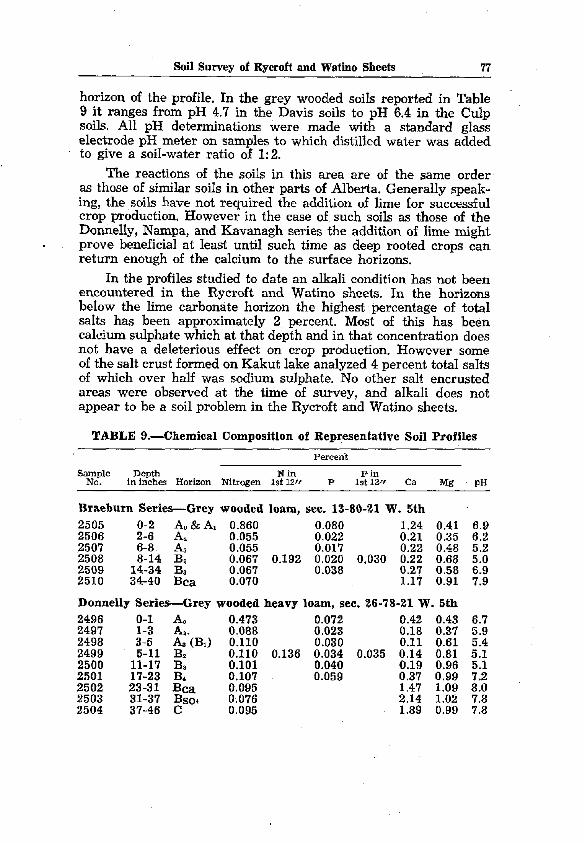
Soi1 Survey of Rycroft and Watino Sheets 77
horizon of the profile. In the grey wooded soils reported in Table 9 it ranges from pH 4.7 in the Davis soils to pH 6.4 in the Culp soils. Al1 pH determinations were made with a standard glass electrode pH meter on samples to which distilled water was added to give a soil-water ratio of 1: 2.
The reactions of the soils in this area are of the same order as those of similar soils in other parts of Alberta. Generally speak- ing, the soils have not required the addition of lime for successful trop production. However in the case of, such soils as those of the Donnelly, Nampa, and Kavanagh series the addition of lime might prove beneficial at least until such time as deep rooted crops cari return enough of the calcium to the surface horizons.
In the profiles studied to date an alkali condition has not been encountered in the Rycroft and Watino sheets. In the horizons below the lime carbonate horizon the highest percentage of total salts has been approximately 2 percent. Most of this has been calcium sulphate which at that depth and in that concentration does not have a deleterious effect on trop production. However some of the salt trust formed on Kakut la,ke analyzed 4 percent total salts of which over half was sodium sulphate. No other salt encrusted areas were observed at the time of survey, and alkali does not appear to be a soi1 problem in the Rycroft and Watino sheets.
TABLE 9.-Chemical Composition of Representative Soi1 Profiles
s”” Depth Nill Pin in inches Horizon Nitrogen 1st 12,~ P 1st 12rf Ca Mg pH
Braeburn Series-Grey wooded loam, sec. 13-80-21 W. 5th 2505 o-2 Ao&A, 0.860 0.080 1.24 0.41 2506 2-6 A, 0.055 0.022 0.21 0.35 2507 6-8 AS 0.055 0.017 0.22 0.48 2508 8-14 Bz 0.067 0.192 0.020 0.030 0.22 0.68 2509 14-34 B, 0.067 0.038 0.27 0.58 2510 34-40 Bca 0.070 1.17 0.91
Donnelly Series-Grey wooded heavy loam, sec. 26-78-21 W. 5th 2496 O-l Ao 0.473 0.072 0.42 0.43 2497 3:; k(B~j :'!!i 0.023 0.18 0.37 2498 2499 5-11 Bz 0:llO 0.136 :':i: 0.035 i*:i t:: 2500 11-17 Bs 0.101 0:040 0:19 0:96 2501 17-23 Ba 0.107 0.059 0.37 0.99 2502 23-31 Bca 0.095 1.47 1.09 2503 31-37 Bsos 0.076 2.14 1.02 2504 37-46 C 0.095 1.89 0.99
2:; 510
E

78 Bulletin No. 53
TABLE 9.-Chemical Composition of Representative Soi1 Profiles (Continued)
Percent
Sai?o?e Depth N in Fin in inches Horizon Nitrogen 1st 12” P 1st 12/f Ca Mg pH
Esher Series-Degraded black silt loam, sec. 16-77-5 W. 6th 2797 O-4 Al 0.776 0.084 0.50 0.45 6.2 2798 4-6 A2 0.365 0.446 0.0'76 0.30 0.42 6.1 2799 6-8 A, (B,)
$;E; 0.24 0.73 6.3
2800 8-14 33% O"S; 0:055 0.29 0.74 6.6 2801 14-24 Ba 0:136 0.066 0.92 0.79 8.5 2802 $3; c" 0.115 0.065 1.53 1.04 8.0 2803 0.109 0.066 0.85 1.04 8.2
Nampa Series-Grey wooded silt loam at Illustration Station, sec. Z-78-20 W.5th
2688 o-2 &&A, 0.372 0.098 0.76 0.33 2689 2-6 Az 0.061 0.125 0.034 0.047 0.31 0.31 2690 6-9 As (B,) 0.0915 0.035 0.25 0.61 2691 9-15 B, 0.081 0.043 0.25 0.73 2692 15-21 Bs 0.075 0.052 2693 21-25 Bd 0.099 0.067 y& ;.y;
2694 25-30 Bca 0.087 0.079 1:23 0:77
Falher Series-Degraded black silt loam, sec. 6-78-21 W. 5th 2461 O-l Ao 1.101 0.219 1.59 0.81 2462 l-4 A1 0.488 0.092 0.48 0.81 2463 4-8 As (B,) 0.214 0.329 0.068 0.27 0.62 2464 8-12 B, 0.156
;.;W;
2465 12-18 Bs 0.134 0:041 0.27 0.90 0.26 0.91
2466 18-26 Ba 0.128 0.058 0.44 1.07 2467 26-30 Bca 0.110 1.55 1.24 Rycroft Series-Black silt loam, sec. 9-78-21 W. 5th 2489 O-6 Ao&A, 0.753 0.109 2490 6-8 A, 0.171 0.051
;.;;
2491 8-10 As (B1) 0.113 0.034 0:23
$4;
0:57 2492 10-16 Bz 0.180 0.454 0.064 0.079 0.28 1.10 2493 16-22 B, 0.162 0.063 0.50 1.03 2494 22-34 Bca 0.113 1.21 0.93 2495 34-42 B~oa 0.101 1.81 1.10
Prestville Series-Silty clay loam-thln peat, sec. 34-78-l W. 6th 2281 o-3 A0 1.249 0.176 2.12 0.47 2282 3-7 A, 0.477 0.54 0.155 0.13 0.66 0.60 2283 7-13 Bx 0.159 0.082 0.40 0.59 2284 13-20 Bz 0.125 - 0.40 0.67
5.5 5.2 5.0 5.2
:-5 7:6
6-3 6:4 6.8
2 8:0
7:: ::9
Judah Series-Degraded black (brown fores0 silt loam, sec. 8-78-22 W. 5th
2481 o-1 Aa 0.790 0.090 1.35 0.51 7.4 2482
3:; 2 0.320 0.043 0.54 0.51 7.1
2483 0.128 0.017 0.31 0.51 6.7 2484 6-12 BI 0.113 0.208 OO.;;; 0.028 0.32 0.80 6.2 2485 12-18 B, 0.101 2486 18-24 Bs 0.107 0:053
0.39 0.93 5.7 0.89 0.81 7.2
2487 g-3; Bc"" 0.092 9.02 1.14 8.2 2488 0.076 5.48 1.29 8.1

Soi1 Survey of Rycroft and Watino Sheets
TABLE 9.-Chemical Composition of Representative Soi1 Profiles (Continued)
Percent
SaNOple Depth N in Pin in inches Horizon Nitrogen 1st 12ff P 1st 12fr Ca Mg
Judah Series-Degraded black (brown forest) silt loam, sec. 22-78-l W. 6th
2275 O-3 Ao 1.199 0.097 2.02 0.47 2276 3-7 AI 0.264 0.049 0.45 0.48 2277 7-11 A3 0.100 0.429 0.049 0.059 0.22 0.58 2278 11-17 B, 0.097 0.023 0.32 0.87 2279 17-23 Bz 0.105 0.42 0.86 2280 at 30 Bca 4.16 1.13
Bronco Series-Black silt loam, sec. 31-78-5 W. 6th 2749 O-3 Al 0.940 0.125 1.22 0.38 2750 3-8 A3 0.516 0.101 0.76 0.59 2751 8-13 Bx 0.265 0.476 0.072 0.091 0.56 0.44 2752 13-20 Bz 0.139 0.063 0.54 0.66 2753 20-24 BS 0.125 0.066 0.60 0.88
Davis Series-Grey wooded silt loam, sec. 11-78-23 W. 5th 2475 2476
20:; b 0.470 0.050 0.65 0.28 0.070 0.017 0.19 0.29
2477 6-12 B> 0.082 0.143 0.019 0.023 0.13 0.62 2478 12-20 Bn 0.067 0.035 0.19 0.76 2479 y;;; Bc"" 0.058 6.46 1.21 2480 0.055 5.21 1.24
Davis Series-Grey wooded silt loam, sec. 30-79-4 W. 6th 2305
Z-6 A &AI A:
0.204 0.049 0.54 0.32 2306 0.151 0.036 0.38 0.42 2307 6-8 B1 0.091 0.129 0.028 0.036 0.20 0.47 2308 8-14 BS 0.088 0.034 0.30 0.73 2309 24-30 Bca 2.30 0.90
. Tangent Series-Degraded black silt loam, sec. 20-80-l W. 6th 2779 O-3 A1 0.581 0.076 0.86 0.37 2780 3-5 Ae 0.271 0.242 0.060 0.058 0.59 0.37 2781 5-8 As(AB) 0.035 0.27 0.37 2782 8-16 Bz
;JE; 0.061 0.31 0.43
2783 16-30 Bca 0:071 0.079 6.53 0.88
Culp Series-Grey wooded Ioamy Sand, sec. 36-77-24 W. 5th 2516 o-2 Ao8z A1 0.062 2.28 2517 2-8 Az
Ez
2518 8-14 A, 0:021 0.192 Ez1 0.037 E 2519 14-20 Bz 0.049 0:020 0:17 2520 20-26 B3 0.046 0.048 0.22 2521 26-32 B, 2522 32-40 B&
0.046 0.035 1.88 4.08
2523 40-48 Bca E? , 4.55
0.23 0.18 0.20 0.30 0.38 0.55 0.67 0.71
Alluvium-Immature soi1 on river flat, sec. 3-78-24 W. 5th 2303 O-8 A 0.428 0.102 0.66 0.30 2304 8-24 B 0.153 0.336 0.069, 0.091 0.38 0.39
PH
7:; 56:: i::
25 El 6:s
z 2: 7:9
77:: 7-i 8:6
E 7:o
B:$
8-3 8:4
6.8 .5.7

80 Bulletin No. 53
TABLE 9.-Chemical Composition of Representative Soi1 ProfiIes (Continued)
Syofle Depth N in Pin in inches Horizon Nitrogen 1st 12/r P 1st 12fr Ca Mg pH
Peoria Series-Black silt Ioam, sec. 1-78-l W. 6t& 2285 ;:;2 2 0.766 0.092 0.62 0.41 6.7 2286 0.094 0.534 0.78 0.22 0.30 6.7 2287 12-16 B 0.102
;.fl;
0:062 0.30 0.46 6.9
2288 16-24 D 0.105 0.38 0.63 7.8 2289 24-30 ca 5.82 1.03 8.1
Peoria Series-Degraded black silt loam, sec. 21-76-3 W. 6th 2315 O-8 A1 0.219 0.055 0.26 0.32 6.3 2316 8-12 Aa 0.066 0.168 0.073 0.061 0.14 0.33 6.0 2317 12-14 B 0.074 0.035 0.20 0.43 5.7 2318 14-24 D 0.071 0.063 0.18 0.58 5.6
Kavanagh Series-Black silt Ioam solonetz, sec. 22-76-3 W. 6th 2310 O-4 A1 0.505 0.106 0.20 0.36 6.0 2311 4-6 Az 0.275 0.086 0.20 0.26 6.1
%8 8-14 6-8 B, B,,
;AN;
0:162
;.;W4
0.16 0.18 0.53 0.63 6.7 7.5
Eaglesham Series-Sedge peat soil, sec. 21-79-21 W. 5th 2511 O-16 1 1.031 1.031 0.094 0.094 1.53 0.25 5.8 2512
:;:;: ; 0.796 0.080 0.98 0.75 6.8
2513 :*11;3 0.071 0.79 0.82 7.3 2514 20-28 4(D)
0:113 0.118 0.98 0.74 7.8
2515 28-36 5 (ca) 2.48 1.03 7.9
Kenzie Series-Moss peat soil, sec. 29-75-U W. 5th 2864 O-8 1 0.708 0.049 0.82 0.18 4.7 2865 8-13 2 y.;:; 0.641 ;.;tM; 0.046 1.12 0.10 4.3 2866 13-19 3 1.82 0.14 4.8 2867 19-28 4 (D) 0:025 0:031 0.32 0.31 6.8 2868 28-34 5 (D) 0.078 0.045 0.66 0.74 7.0 2869 34-40 6(D) 0.090 0.075 0.62 0.61 7.2

Soi1 Survey of Rycroft aud Watiuo Sheets 81
GLOSSARY*
Aeolian deposition-Wind laid material. Aggregate (soilj-A single mass or cluster of soi1 consisting of many
soi1 particles held together, such as a prism, granule or crumb, etc. Alluvium-Water transported, recently deposited material on which
the soi1 forming processes have not acted long enough to prqduce distinct soi1 horizons.
Available plant nutrients-Plant nutrients in soluable form, readily available to the plant roots.
Calcareous material-Material containing a relatively high percentage of calcium carbonate. Will effervesce visibly when treated with hydrochloric acid.
Claypan-A dense and heavy soi1 horizon underlying the Upper part of the soil; hard when dry and stiff when wet.
Cleavage-The capacity of a soi1 on shrinkage to separate along cer- tain planes more readily than on others.
Concretions-Local concentrations of certain chemical compounds, such as calcium carbonate or compounds of iron, that form hard grains or nodules of mixed compositions and of various sizes, shapes and coloring.
Consistence-The relative mutual attraction of the particles in the whole soi1 mass or their resistance to separation or deformation. Described by such terms as loose, compact, mellow, friable, plas- tic, sticky, soft, firm, hard and cemented.
Degradation-Change of one soi1 type to a more leached one. Drift-Material of any sort deposited in one place after having been
moved from another. Glacial drift includes ail glacial deposits whether unstratified or stratified.
Erosion-The wearing away of the land surface by running water, wind, or other geological agents. It includes both normal and accelerated soi1 erosion. The latter is brought about by changes in the natural caver or ground conditions and includes those due to human activity.
(a)
(b)
(cl
Sheet-Removal of a more or less uniform layer of material from the land. surface. Rill-A type of accelerated erosion that produces small chan- nels which cari be obliterated by tillage. Gully-Erosion-produced chaniels th& are larger and deeper than rills and cannot be obliterated by tillage. Ordinarily they carry water only during and immediately following rains or following the melting of snows.
Flocculate-To aggregate individual particles into small groups or granules: used especially with reference to clay and colloidal be- haviour. The reverse of flocculate is deflocculate, commonly re- ferred to as puddling.
Flood Plain-The nearly flat surface subject to overflow along stream courses.
*This is net a complete glossary, but is primarily to define some of the terms com- monly used in this report.

82 Bulletin No. 53
Friable-Easily crushed in the fingers, non-plastic. Glei-A soi1 horizon in which the material has been modified by a
fluctuating water table. It is frequently mottled with rusty brown and grey and is generally compact and sticky.
Green manure trop-Any trop that is plowed under for the purpose of improving the soi& especially by the addition of organic matter.
Horizon-A layer in the soi1 profile approximately parallel to the land surface with more or less well defined characteristics that have been produced through the operation of soi1 building processes.
Humus-The well decomposed, more or less stable part of the organic matter of the soil.
Impervious materials-Materials which resist the passage of drainage water and plant roots.
Lacustrine materials-Materials deposited by or settled out of lake waters.
Lithosol-A soi1 having no clearly expressed soi1 characteristics and consisting of an imperfectly weathered mass of rock fragments.
Mature soil-A soi1 with well developed characteristics produced by the natural processes of soi1 formation and in equilibrium with its environment.
Muck-Fairly well decomposed organic soi1 material relatively high in minera1 content, dark in color and accumulated under condi- tions of imnerfect drainage.
Nutrients (Plant)-The elements taken in by the plant,. essential to its growth, and used by it in the elaboration of lts food and tissue. These include nitrogen, phosphorus, calcium, magnesium, potassium, sulphur, iron, manganese, copper, boron and perhaps others obtained from the soil; and carbon, hydrogen and oxygen obtained largely from the air and water.
Organic soil-A general term used in reference to any soi1 whose solum is made up of predominantly organic material.
Peat-Unconsolidated soi1 material consisting largely of undecom- posed to partially decomposed organic matter accumulated under conditions of excessive moisture.
pH-A notation used to designate the relative acidity or alkalinity of soils and other materials. A pH of 7.0 indicates neutrality, higher values indicate alkalinity and lower values acidity.
Podsolization-A general term referring to that process by which soils are dealeted of bases: become acid and develon leached A horizons:Specifically the term refers to the process by which grey wooded soils are formed and in which the iron and alumina are removed from the Upper part of the profile more rapidly than is the silica. This results in the development of light colored surface horizons.
Profile-A vertical section of the soi1 through a11 its horizons and extending into the parent material.
Relief-The elevations or inequalities of a land surface when con- sidered collectively. Minor surface configurations, such as slight :CL~, ridges or shallow depressions are referred to as mmro-
Solonetzic soils-Soils developed on somewhat saline parent material tu&yozoor dramage conditions and charactenzed by a comnact B
Solum-The Upper part of the soi1 profile, which is above the parent material and in which the processes of soi1 formation 3-e taking place. It includes the A and B horizons.

Soi1 Survey of Rycroft and Watino Sheets 83
Stones-In this report no attempt is made to classify stones according to size or material. Most of the stones are granites and quartzites, and vary from cobbles to large boulders. The following broad classification is used in designating their frequency of occurrence:
Stones few-Stones sparsely scattered over the fields. Picking if required Will yield not more than about one load per acre.
Stones some-Indicates numbers in sufficient amount that they hinder cultivation and must be removed-possibly three to five loads per acre.
Stones many-Fairly stony land-possibly ten or more loads per acre.
Very stony-Indicates land on which it may be unprofitable to clear the stones..
Stratified-Composed of or arranged in strata or layers. The term is applied to parent materials. Those layers that are produced in soils by the processes of soi1 formation, are called soi1 horizons, while those inherited from the parent material are called strata. Thin horizontal layers are often referred to as laminae, strata up - -. to about 12 inches in depth as bands, and those over 12 inches in depth are referred to in this report as beds.
Structure (soil)-The aggregates into which thendividual soi1 par- ticles are arranged. Often one type of aggregate occurs within another. For example, the columnar structure of solonetzic soils Will break down into smaller aggregates. The term macrostruc- ture is used to designate the large columnar structure and meso- structure for the smaller blocky or nuciform aggregates. Still finer subdivisions of structure are sometimes referred to as micro- structure. The following structures are recognized in this report:
Blocky-Block-like aggregates with Sharp angular corners. Nuciform-Nut-like aggregates with more or less clearly defined
edges and faces that are sub-rectangular. Granular-More or less rounded soi1 aggregates with an absence of
smooth faces and edges, relatively non-porous. Platy-Thin horizontal plates or aggregates in which the horizontal
axis is longer than the vertical. Columnar-Fairly large aggregates with the vertical axis longer
than the horizontal and with fairly well defined and regular edges and surfaces. The tops may be rounded. Usually found in the Bz horizon.
Prismatic-Fairly large aggregates with a vertical axis longer than the horizontal and with fairly well defined edges and surfaces. The tops of the aggregates are usually flat.
Massive-Large cohesive masses of soil, almost amorphous or struc- tureless. with irregular cleavage faces.
VesicularLA soi1 structure that Ts characterized by small round or oval cavities or vesicles. Crumb structure is the term applied to porous granular aggregates.
Various grades of structure depend on the degree of distinct- ness of aggregation and the durability of the aggregates to dis- placement or gentle crushing. The terms used to denote the grades of structure are: structureless, weak, moderate and strong.
Terrace-A flat or undulating plain bordering a river or a lake. Many streams are bordered bv a series of terraces at different levels indicating flood plains at successive periods. Although many older terraces have become more or less hilly through dissection by streams or wind action, they are, still regarded as terraces.

a4 Bulletin No. 53
Texture (soiil-Refers to the relative proportion of the various size groups of individual soi1 grains. Size groups larger than .05 mm. in diameter are called Sand, those from .05 mm. to .002 mm. are caIIed silt, and those lexhan .002 mm. in diameter are called clay. Therelative proportion of these soi1 separates in the soi1 Classes most commonly referred to in this report is as follows: Sand: contains over 90% Sand sized soi1 grains. Loamy Sand: contains from 80% to 90% sand sized soi1 grains. Sandy loam: contains from 50% to 80% Sand and not more than
25% clay sized soi1 grains. Loam: contains not more than 50% Sand, not more than 50%
silt and not more than 25% clay sized soi1 grains. Silt loam: contains over 50% silt sized soi1 grains. Clay loam: contains from 25 % to 40 % clay sized soi1 grains. Clay: contains over 40 % clay sized soi1 grains.
Till-A heterogenous mixture of stones, Sand, silt and clay transported by glaciers and deposited during the melting and subsequent recession of the ice front.
,
Till t-o;in-A level or undulating land surface covered by glacial
Water table-The Upper limit of the part of the soi1 or underlying material wholly saturated with water.
Weathering-The physical and chemical disintegration and decomposi- tion of rocks and minerals.
Zona1 soils-Any one of the great soi1 groups having well developed soi1 characteristics that reflect the influence of climate and living organisms, chiefly vegetation. In the surveyed area these groups include the grey wooded, degraded black and black soils.
., . . :,: . -.
