unit rationale and overview: mexico - lisa...
TRANSCRIPT

Unit Rationale and Overview: MEXICO Objective: To introduce students to the geography, history, economics, government, and culture of Mexico.
Rationale: Students should be introduced to different cultures, civilizations, and communities around the world to understand how certain cultures, geographic regions, economy’s, and histories from one country affect their own and others’ including each countries ways of life. They should make connections to people from similar and different cultural groups to develop an understanding of how we learn from each other and live together in a global society. Students should learn how different countries form their governments and how their government and economy influences their community. They should be able to discuss the similarities and differences of other countries (government, economy, and roles of citizenship) to their own.
On-going and Before Unit Prep
Prepare bulletin board outside of class with student photos (with sombrero, maracas, or other culturally relevant materials). Include student’s names, title of unit, and Bienvenidos.
Create and send home newsletter to parents/guardians introducing the new unit of study: Mexico (November Newsletter- Mrs. Luckman)
Prepare Comprehensive Power Point with all lesson content to be shown as review each day and to allow students who may be absent the opportunity to review the content covered each day.
Prepare Photos books with real life current photos of Mexico.
Posters (Poster each for Geography, History, Gov’t, Economy, and Culture) - picture wall includes clip art from power point

Centers:
Reading Center: stocked with books to explore Mexico (non-fiction, folktale, and fiction): everyday on-going
Reading/Writing: ABC Geography Facts Hunt: after geography lesson
Math: Mayan Math: after history lesson
Writing: After reading Borreguita and the Coyote in Whole group, students will create a response to the prompt ―I feel smart when.. why…‖
Writing /Illustrating: Spanish Who Am I word book: after culture lesson
Computer: National Geographic Kids- explore Mexico- after geography lesson- http://kids.nationalgeographic.com/kids/places/find/mexico
Art: Ojo de Dios craft – after culture lesson
Schedule: 8 Lessons- includes day for educational craft
1 day Review
1 day Test
1 day Fiesta
Total 11 day Unit spanning 7 weeks
Read aloud books/resources:
Post Cards from Mexico by Helen Arnold (for postcard assignment)
Look What Came from Mexico by Miles Harvey (random pages for culture)
Mexico’s Fight for Independence by Terry Shannon (History)
The Mighty Saguaro Cactus by David Meissner (Economics)
Pancho’s Pinata by Stefan Czernecki and Timothy Rhodes (culture)
Too Many Tamales by Gary Soto and Ed Martinez (culture)
Borreguita and the Coyote by Verna Aardema (culture- literature/writing)
P is for Pinata: A Mexico Alphabet by Tony Johnston (culture)
Resources and references:
Mexico: Activities, Projects, Poster, Audio Tape, and Map by Linda Scherr and Mary Oates Johnson (Scholastic, 1995)
Mexico Activity Book: Explore Mexico Through Art, Crafts, Cooking and Historical Aids by Mary Jo Keller (EduPress, 1996)
Mexico by Jane Routte and Ann Barnell (Teacher Created Materials, Inc, 2001)
Mexico: Land of Old and New by Eileen Guiffre Cotton, Carole F. Stice, and Jean Marie Ryan (Book 2Web, 2001)
Taking Your Camera to Mexico by Ted Park (Steck-Vaughn Co. Harcourt Co, 2000)
Guide to Mexico by Brian Williams (highlights, 1995)
A Ticket to Mexico by Tom Streissguth (Carolrhoda Books, Inc, 1997)

Countries of the World by Michael Dahl (Bridge stone books, 1997)
Postcards from Mexico by Helen Arnold (Steck-Vaughn, 1996)
Look What Came From Mexico by Miles Harvey (Scholastic, 1998)
P is for Pinata: A Mexico Alphabet by Tony Johnston (Sleeping Bear Press, 2008)

Lesson 1 (week 1): Geography
Anticipatory Set in Spanish
KWL Chart -whole group dry erase board then transfer to poster board to re-visit at end of unit
World Map- locate Mexico
Mexico Map- present geographic locations as per lesson
Geography poster
Assessment: Mexico Map (color and label)
Assessment: Topography map color accdg. To key using mapping skills
Summative Assessment: Map also used at end of unit in Test Packet
Power Point review slides 1-13
CENTER: Reading/Writing: ABC Geography Fact hunt
CENTER: Reading: Explore Mexico books
Lesson 2: (week 1): History
Review Day 1
Olmec, Zapotecs, Mayans, and Aztecs
Colonial Mexico, Mexico’s Independence
Read: Mexico’s Fight for Independence
History Poster

Assessment: Cloze Activity History leading up to Independence
Power Point review
CENTER: Math: Mayan Math
CENTER: Reading: Explore Mexico
Lesson 3 (week 2): Government
Review
Flag and Story of Flag
Class Discussion: Compare/Contrast US and Mexico: currency, presidency, states, etc
Assessment: Flag Label (meaning of colors) and color
Read: A Ticket to Mexico, certain pages
Government Poster
Power point Review
CENTER: Computer: National Geographic Kids: Mexico
CENTER: Reading: Exploring Mexico
Lesson 4 (week 3): Economics
Review
Currency, agriculture, industries, natural resources, imports, exports

Assessment: Start Venn diagram with students, complete individually (model and explain)
Assessment: Acrostic Poem: ―MEXICAN PESOS‖ (model)
Economics poster
Power Point Review
CENTER: reading/writing ABC geography con’t
CENTER: reading: Exploring Mexico
Lesson 5 Week 3: Culture day 1 of 4— Music/Literature/Art/Food
Read Aloud- Borrequita and the Coyote, discuss
Discuss Aztec legends
Listen to music
Photo Sharing
Culture poster
Assessment Create Postcard from Mexico detailing what culturally relevant event they witnessed or visited
Illustrate side 1, write side 2
CENTER: Writing: Response to Borrequita: Given Prompt:
―I feel smart when…why..‖ illustrate
READING: Explore Mexico
COMPUTER: National Geographic Kids

Lesson 6 Week 4: Culture day 2 of 4—Cultural Craft
Review Aztec legends/traditions
New Cultural Craft: Aztec Mosaic Mask
Hang in hall next to photos
Culture Poster
Power Point review
Finish Postcard
CENTER: Cultural craft: Ojo de Dios (2-3 days)
CENTER: Reading: Explore Mexico: photo scrap book
Lesson 7 Week 4: Culture day 3 of 4— Language/Holidays/Traditions
Introduce students to Spanish, discuss colors, numbers, days, etc
Discuss traditions compare to US
Assessment: Spanish word books worksheet- DBA
Re-visit opening day 1 Spanish words
Culture Poster
CENTER: Cultural Craft con’t
READING: Explore Mexico
WRITING: Finish unfinished work

Lesson 8 Week 5: Culture day 4 of 4—Animals, Sports, A day in the life
Nature, wildlife, sports, a day in the life.
Discuss animals and location
Culture Poster
VIDEO: Mexico: A day in the Life
Assessment: Web of animals
Day 9: Week 6 Review for Test
Use PowerPoint in its entirety; refer to each poster for review
Assessment: Informal Class Discussion, Q/A, Thumbs up/Thumbs Down
Day 10: week 6 TEST
Document Based Test: Read in its entirety to class with time to complete each section
Day 11: FIESTA!!
Wrap up

LESSON PLAN
NAME: ___Lisa Pickard____________________________DATE: _11/5/2010________
LESSON: Social Studies: Geography of Mexico NO. OF CHILDREN:26___
TIME ESTIMATE: __50 Minutes_______________ ___GRADE LEVEL: 3rd_____
1. INTENDED STUDENT OUTCOMES
a. Students will correctly locate, on a Mexico geographical mapping worksheet,
bordering countries and oceans, rivers, capital city, and label a compass rose.
b. Given a topography map of Mexico and key, students will use their mapping
skills to correctly identify each geographical region of Mexico with relation to
mountains, deserts, plains, rainforests, and plateaus.
2. New York State Standards Social Studies #3 Elementary Geography Key Idea 1 (geography is divided into
essential elements which can be used to analyze important geographic questions
and issues. The elements include: the world in spatial terms, places and regions,
physical settings, human systems, environment and society, and the use of
geography) Performance Indicators 2 (draw maps and diagrams that serve as
representations of places, physical features, and objects), 3 (locate places within
the local community, State, and nation, locate the Earth‟s continents in relation to
one another), 4 (identify and compare the physical, human, and cultural
characteristics of different regions of people)
Social Studies #3 Elementary Geography Key Idea 2 (geography requires the
development and application of the skills of asking and answering geographic
questions; analyzing theories of geography, and acquiring, organizing, and
analyzing geographic information) Performance Indicator 1 (ask geographic
questions about where places are located; why they are located there; what is
important about their location; and how their locations are related to the location
of other people and places), 2 (gather and organize geographic information from
a variety of sources and display in a number of ways)
II. PREPARATION
1. Materials:
a. Student materials
Pencil, crayons
b. Teacher materials
KWL dry erase poster
Poster paper to transcribe KWL chart at the end of class to refer back to in
later lessons
Comprehensive Power Point for entire Mexico Unit
Computer and TV for projection
World map
World Globe
Map of Mexico as whole

Geographic map of Mexico with locations
Topographic map of Mexico
Map breaking Mexico down to states- Power Point
Geographic map worksheets for each student
Topographic map worksheet for each student
Laminated poster of the day labeled Geography
Map labeling worksheet to be given at end of unit as part of unit test.
2. Prior Knowledge No prior on Mexico necessary.
Prior knowledge of the terms geography, topography, land forms
Prior knowledge of mapping skills, how to read a map and locate items
3. Need to Do Ahead of Time:
Prepare and laminate poster board labeled geography, hang for student to see
Prepare Power Point
Copy map and topography worksheets, one for each student
Queue PowerPoint on computer
Have world map and globe accessible
Hang Poster and KWL chart
Prepare student bulletin board with pictures for hallway prior to lesson
III. BODY OF THE LESSON
A. Setting the Stage for Learning/Anticipatory Set: (4 minutes)
Teacher “ Hola, Bienvenidos, Como esta, amigos? Me llamo Ms. Pickard” Wow,
boys and girls we have just finished up Australia last week and we are moving on
to our next country. Has anyone noticed our new bulletin board outside our class?
Can anyone guess what our next country is? Mexico. Our unit on Mexico is going
to last the next seven weeks. At the end of our unit you will be able to describe
Mexico‟s geography, history, government, economy, and culture. We are going
to do some very fun and exciting activities over the next seven weeks and we are
going to incorporate a few new fun centers allowing us to explore Mexico even
further. We are going to learn some very interesting things about Mexico. Some
of the facts and information we learn you may already know, and please feel free
to share with the class, but some of the information that I present you may never
have imagined before. Today we are going to learn about the Geography of
Mexico and complete two maps including significant places and regions.
B. Steps of the lesson:
Whole group:
1. (3 min) Boys and girls, Mexico is a very old country. It is a very amazing,
beautiful, and colorful country with an extremely diverse climate, depending on
where you are in Mexico. Some of Mexico‟s ancient cities, ruins, and treasures
are still visible among the more modern cities.

Mexico holds a very special place in my heart as well. I have family that was born in
Mexico and I still have family that lives in Mexico and I hope to visit them soon.
Has anyone here ever visited Mexico? Or have family in Mexico? If so, where?
When you want to visit a country, any country (or state or city) it is very important to
learn about the country before you visit it. Knowing the geography is important-
Can anyone think of a reason why? Call on students- guide answers to include:
the geography tells us a lot about the region, the climate, the temperature,
knowing this information is a key to knowing what to wear if we visit during
different parts of the year. Give example, It would be silly to visit Florida in
November and show up in a snow suit but it would be perfectly fine to show up
in Lockport in a snow suit. (makes a connection to prior knowledge and
establishes the importance of geography)
The first thing we are going to do today is take a few minutes and create a list of
what we know about Mexico and what we want to learn about Mexico, and then
after our unit we are going to re-visit our list to see what new information we
learned.
2. (5 min) Create KWL chart with student discussion. Ask for ideas fill in chart
3. (2 min) Next, use the world map to locate Mexico. State to students “Mexico is on
the continent of North America”.
Ask students: “How many continents do we have in all, can anyone name them?
Call on students. Queue the Power Point to follow along with teaching and to use
as another visual aid.
4. Hand out first worksheet to students: Geographic labeling sheet. Tell students we
are going to color specific areas as we discuss them. (1 min)
5. Review Compass directions (N,S,W,E) Draw compass rose on board- Ask, “Where
should I label my compass for North? Have students raise hand to point in
direction. Write South on board. Ask, “Where should west be written? Have
students point in correct direction. Hold up globe and locate Mexico. Tell
students “Please go ahead and label the compass rose on your sheet” Walk room
check for understanding and correct answers.
6. (14 min) To the North of Mexico we have the US (color). The Ocean to the West
is the Pacific Ocean (color), off the east coast we have the Gulf of Mexico (color)
, In between the US and Mexico we have a long river separating the two countries
called the Rio Grande, bordering countries to the South are Belize and Guatemala
(color), Capital of Mexico is Mexico City. (Please circle). Ask students: “Does
anyone know our country‟s capital city?” Call on students. Walk the room
checking for understanding, assist and guide where needed. Provide additional
instruction if necessary.
8. (19 min) State to class „Now that we know where Mexico is, let‟s talk about the
different regions of Mexico and about their different climates and the landforms
present in each and possible weather events” (locate each as presented on map and
allow students to color according to key)
Handout individual worksheet on topography. Have students complete
individually according to directions. Walk the room to check for understanding.
Baja California Peninsula, and North West Coast, Northern Mexico - Sonoran
Plains, deserts
Does anyone know what a peninsula is? Call on student. Define

Peninsula- a section of land that extends out from a larger piece of land and is almost
completely surrounded by water
Does anyone know what a plain is? Call on student for answer. Define
Plain- large level of flat land
Can anyone describe a desert? Call on student. Define
Deserts- dry sandy region
Central Mexico- Western (Occidental) Sierra Madre Mountains and highlands,
plateaus, and as you reach farther east you reach more plains
Who can tell me what a mountain is? Call on student. Define
Mountains-part of Earth‟s surface that rises to the sky
Highlands- are the mountain ranges
Does anyone know what a plateau is? Call on student. Define
Plateaus-area of flat raised land
Gulf Coastal Plains of Mexico- the north east coastline is generally dry with thorny
bushes and trees (Coastal Plain)
Lowlands- coastal plains
Southern Mexico –There are volcanic Eastern (Oriental) Sierra Madre Mountains,
highlands, and rainforests as you go further south, Volcanoes (opening of Earth‟s
surface through which hot melted rock shoots up) at the Sierra Madre Mountains.
On the south east coast you may find Tsunamis (a huge tidal wave or waves
caused by an earthquake), Earthquakes (shaking of the ground by underground
rocks), and Hurricanes (big storm with strong winds and heavy rains),
State “Several of the world‟s most active volcanoes stand among Mexico‟s
mountains. One of the largest is Popcatepetl or “Smoking Mountain” “Popo” as
locals call it. (poh-poh-kah-THE-pehtl)
Who can tell me what they think a rainforest is? Call on student. Define.
Rainforests- thick, green forests that are hot, wet areas near the equator rains
frequently (about 200 days of the year)
Yucatan Peninsula-sandy beaches, coral reefs, rainforests, wetlands
Wetlands- wet spongy land, marshes, and swamps
(Connect to Prior learning)-Where have we learned about coral reefs before?
Australia.
Centers after lesson to include:
Reading: ABC Geography Fact Hunt by exploring Mexico related texts
Computer: National Geographic Kids website at
http://kids.nationalgeographic.com/kids/places/find/mexico

C. Accommodations:
No IEP‟s or 504‟s in class. No individual modifications required.
1. Tier 1 RtI students
a. Power Point for review and presentation
b. Multiple maps and diagrams to visually present in multiple ways
c. Student can use computer during center time to log onto
http://kids.nationalgeographic.com/kids/places/find/mexico
for additional geographic information
2. Auditory Input delays- requiring additional time to process information
a. Students will have access to Power Point to refer to during center time for
additional time to review and receive knowledge
b. Unfinished work can be continued during first center of the day
Remedial and additional help needed: Students can review Power Point
presentation during computer center. Students can also go to the website:
http://kids.nationalgeographic.com/kids/places/find/mexico
for additional geographic information
Enrichment Activity: Students can Explore Mexico books set up in the
reading center. They can also complete the ABC Geography sheet, locating
and learning facts about Mexico.
Unfinished Work: No unfinished work anticipated. However, if there is
unfinished work or student absences, students will be given a block of time
called “ketchups” on Friday afternoon to make-up missed work and to catch
up on unfinished work.
D. Closure: (3 min)
“Boys and girls, as we finish our topography maps, who can tell me something
they learned today? Call on students with hands raised. Review today‟s learning
with the Power Point presentation (slides 1-13: geography).
IV. ASSESSMENT:
Informal assessment: Initial KWL Chart to assess prior knowledge and to inform
instruction. Multiple questions including individual and choral oral responses throughout
the mapping part of lesson to check for understanding of basic geographic items and
terminology.
Formal assessment: Map skills worksheet, completed individually, locating countries,
cities, and oceans bordering Mexico to check for understanding of the major
geographical locations related to Mexico.
Topographic map worksheet, to be completed individually, requiring the use of mapping
skills including reading a key to locate the different regions of Mexico to check for
understanding of the new material presented.
Summative assessment of knowledge at end of unit after unit review: Geographic
worksheet using mapping skills to locate places. Fill in the blank format.
V. REFLECTION: Planning: This lesson is the first lesson in a seven week unit on Mexico. The unit
is broken down by geography, history, government, economics, and culture. The
unit has been developed to target third grade social study curriculum. Throughout
the unit each standard will be addressed. I found it beneficial to create a
comprehensive Power Point summarizing the whole unit to use as part of
instruction, review, and for students who may be absent during a specific day or
may require additional time with the material. I chose not to construct the daily
posters (targeting the specific areas of Mexico) ahead of time but rather we will
construct them as we learn the new information to show our class‟ growth of new
information. This utilizes it more as a learning tool which we will use daily and
refer to often rather than a display. There are many resources for mapping
Mexico, but I specifically chose and created maps that students would label and
color to aid in the visual representation of information to draw attention to the
various regions of Mexico. I chose whole group direct presentation of
information because this lesson requires initial instruction of declarative factual
information. Each lesson in the unit will provide new information to students in a
whole group approach but students will have an opportunity to explore, create,
and manipulate the new information in their daily centers in an individual and
cooperative learning based environment.
Resources:
Amazing Hands-On Map Activities by Rose Farino (Scholastic Teaching Resources,
2001) Countries of the World by Michael Dahl (Bridge stone books, 1997)
Guide to Mexico by Brian Williams (Highlights, 1995)
Mexico: Activities, Projects, Poster, Audio Tape, and Map by Linda Scherr and Mary Oates
Johnson (Scholastic, 1995)
Mexico Activity Book: Explore Mexico Through Art, Crafts, Cooking and Historical Aids by
Mary Jo Keller (EduPress, 1996)
Mexico by Jane Routte and Ann Barnell (Teacher Created Materials, Inc, 2001)
Mexico: Land of Old and New by Eileen Guiffre Cotton, Carole F. Stice, and Jean Marie Ryan
(Book 2Web, 2001)
A Ticket to Mexico by Tom Streissguth (Carolrhoda Books, Inc, 1997)
References
Google Images. (n.d.). Google. Retrieved October 21, 2010, from
http://www.google.com/images
NYLearns.org -- Welcome to NYLearns.org! (n.d.). Welcome to NYLearns.org. Retrieved
October 21, 2010, from http://www.nylearns.org/standards

What I KNOW What I WANT to Know
What I LEARNED


LESSON 2: HISTORY Instructional Information
Ancient Mexico:
1st people who lived in Mexico were Indians of unknown tribes, before
8000 BC who migrated North
They were hunters who lived in small, temporary communities
They followed the herds of Buffalo, Mammoths, and other large animals
As the climate became drier the herds could not find food and eventually
died off
The Indians discovered how to grow plants for food and became farmers
They grew corn, avocados, beans, peppers, squash, and tomatoes
They raised dogs and turkeys for food
By 2000BC, The farmers in the southern highlands used irrigation to
improve crops
Villages grew and they developed the art of pottery and weaving
They built flat-topped pyramids with temples on them and began to
worship gods that could help their crops.
Olmec Indians: 1500 to 200BC
The first Major civilization developed by the Southern edge of the Gulf of
Mexico
They developed cities, established trade with other native groups
They developed a calendar and counting system
They also sculpted massive stone heads as large as 9 feet tall
They worshipped a God that was half human and half jaguar
Jade figures and pottery have been found in the ancient Olmec pyramids
Zapotec Indians: 650 BC to 800AD
Also settled into Southern Mexico
Fierce warriors that also built great pyramids dedicated to the sun and the
moon
To build their religious center at Mont Alban, Zapotec engineers flattened
an entire mountain top and pulled all the materials for the pyramids and
temples up the mountain wall
The studied the stars and developed the first writing system in the
Americas, using hieroglyphics (word-pictures) to record their history on
stone tablets

They were skilled architects and built dams and irrigation channels in the
now state of Wuh HOK ah (Oaxaca)
Mayans: 350BC- 900 AD
The Mayans built a magnificent civilization stretching from central Mexico
to the Yucatan peninsula
They were a very intellectual civilization of highly skilled architects,
sculptors, painters, astronomers, and mathematicians
They devised a calendar more accurate than anything used in anywhere
in the world (at that time) that predicted eclipses and lunar cycles
They devised their own system of math using dots, lines, and shells
They added or subtracted horizontally rather than vertically
o I have a math center to show more of the Mayan math to you
The Mayans were peaceful people, they wore elaborate jewelry on ears,
lips, nose, and neck
They were very religious and worshipped many gods to protect them and
their animals
For some UNKNOWN reason the Mayans suddenly abandoned their
cities. No one knows why.
Possibly climate conditions, or an attack from a neighboring tribe, or a
revolt in power
Vines and weeds soon covered their temples and their cities remained
lost for several centuries.
Aztec Indians: 1250 to 1520 AD
The Aztec Indians were the late comers to Mexico.
They came from the North West part of Mexico
Their legends said they came from a place called Aztlan, the white land,
and it is from there the name Aztec comes from.
They were also known as Mexica, from where the modern name of
Mexico comes from.
The Aztecs built the Last and greatest Indian empire during the mid-
1400’s.
The Empire extended from the Pacific and Gulf coasts
The Aztec Capital, Tay nohch TEE tlahn (TENOCHTITLAN), stood on an
Island in Lake (Tay SKOH koh) Texcoco at the site of Mexico City.
There is a great AZTEC LEGEND that was handed down from generation to
generation.

Many years before they settled in this location a tribal elder had a vision.
Believed to be from the deity Huitzilopochtli.
He had seen an eagle eating a snake while sitting on a cactus. The Aztecs
believed that when they found that symbol they would settle and make their
home there.
They saw the symbol on an island in the middle of Lake Texcoca (Tay SKOH
koh).
They made their home and began building their city.
The city became the Great City of (Tay nohch TEE tlahn) Tenochtitlan.
The Aztecs drained much of the lake and built floating Islands.
The built great pyramids, many houses, schools, and great market places.
It grew to be a city of 250,000 people- the largest city in the world at the
time
The Aztecs were fierce warriors who believed it was their duty to sacrifice
the men they captured in battle.
They grew rich and powerful with gold, silver, and other treasures.
They loved beautiful things, music, and art. Their artisians made many
beautiful bowls, masks, jewelry, and ornaments from their gold, silver,
obsidian, seashells, and turquoise, and other stones.
Their leaders wore cloaks of feathers made from the beautiful parrots,
macaws, and quetzal birds.
Their influence spread throughout Mexico and they adopted previously
used calendars and traditions from other tribes (including the Mayans)
Aztecs were also credited with the discovery of chocolate made from the
cocoa tree
The Spanish Conquest:
In 1519, Herman Cortes landed on the coast of Mexico from Spain looking
for wealth and treasures
As the Spaniards made their way north (Montezuma the Aztec Emperor
heard of their coming) they eventually met up with the AZTECS.
Montezuma met with Cortes and required they be left alone. Cortes later
attacked them with other Aztec enemies. Initially the Aztecs won but
months later Cortes returned.
They surrounded their city and would not let food and goods through.
Eventually the Aztecs surrendered.

The Spaniards leveled their beautiful cities and destroyed their temples
and took their land.
Cortes founded the Mexico City on the ruins of Tenochtitlan and built a
capital building with the rubble of Aztec Pyramids
Mexico was ruled by Spain for almost 300 years. Life for Mexican Indian
people called (Mestizos) was very hard.
A revolt:
Miguel Hildago, a priest, led a revolt against Spanish rule and delivered a
speech called the Grito de Dolores, in which he called for a rebellion so
Mexicans could govern Mexico. Beginning Mexico’s War of
Independence from Spain on Sept 15, 1810.
The war ended on September 16, 1821 with Mexico celebrating their
Independence from Spanish rule.
Still today, Every September 15 Mexico’s president rings a bell and
repeats the Grito de Dolores.
Guadalupe Victoria became the first President of Mexico in 1824.
Mexico became a republic with a president and two-house congress heading the
national government, and governors and legislatures heading the states.
President Felipe Calderon is the current president – since 2006.

Name___________________________________________ Mexican Independence: Cloze Activity
Word Bank
The first major _____________to settle along the southern edge of the Gulf of Mexico was the __________. Massive stone heads, jade, and beautiful pottery has been found in the Olmec ruins. After the Olmec’s, came fierce ___________ and skilled architects known as the _____________. They were an advanced culture that studied the stars and developed the first writing system using _________________. Around a similar time as the Zapotecs, the Mayans settled from Central Mexico down to the Yucatan ______________. The Mayans developed their own system of ________ and mysteriously disappeared around 900 AD. About 350
Aztecs civilization destroyed hieroglyphics Independence Math Mexico City Olmec’s Peninsula revolution warriors Zapotecs
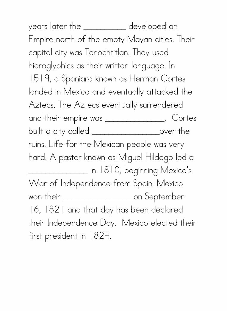
years later the __________ developed an Empire north of the empty Mayan cities. Their capital city was Tenochtitlan. They used hieroglyphics as their written language. In 1519, a Spaniard known as Herman Cortes landed in Mexico and eventually attacked the Aztecs. The Aztecs eventually surrendered and their empire was ______________. Cortes built a city called ________________over the ruins. Life for the Mexican people was very hard. A pastor known as Miguel Hildago led a ______________ in 1810, beginning Mexico’s War of Independence from Spain. Mexico won their ________________ on September 16, 1821 and that day has been declared their Independence Day. Mexico elected their first president in 1824.

Name___________________________________________ Mexican Independence: Cloze Activity
Word Bank
The first major civilization to settle along the southern edge of the Gulf of Mexico was the Olmec’s. Massive stone heads, jade, and beautiful pottery has been found in the Olmec ruins. After the Olmec’s, came fierce warriors and skilled architects known as the Zapotecs. They were an advanced culture that studied the stars and developed the first writing system using hieroglyphics. Around a similar time as the Zapotecs, the Mayans settled from Central Mexico down to the Yucatan Peninsula. The Mayans developed their own system of math and mysteriously disappeared around 900 AD. About 350 years later the Aztecs developed an Empire north of the empty Mayan cities. Their capital city was Tenochtitlan. They used hieroglyphics as their written language. In 1519, a Spaniard known as Herman Cortes landed in Mexico and eventually attacked the Aztecs. The Aztecs eventually surrendered and their empire was
Aztecs civilization destroyed hieroglyphics Independence Math Mexico City Olmec’s Peninsula revolution warriors Zapotecs

destroyed. Cortes built a city called Mexico City over the ruins. Life for the Mexican people was very hard. A pastor known as Miguel Hildago led a revolution in 1810, beginning Mexico’s War of Independence from Spain. Mexico won their Independence on September 16, 1821 and that day has been declared their Independence Day. Mexico elected their first president in 1824.


LESSON 3: Government: Instructional Material
Review History of Mexico: How did the Aztecs know where to build their City of
Tenochtitlan?
Remind and review with Aztec Legend:
The great AZTEC LEGEND that was handed down from generation to
generation.
Many years before the Aztecs settled in this location a tribal elder had a vision
from their god Huitzilopochtlii.
He had seen an eagle eating a snake while sitting on a cactus. The Aztecs
believed that when they found that symbol they would settle and make their home
there.
They eventually saw the symbol on an island in the middle of Lake Texcoca (Tay
SKOH koh).
They made their home and began building their city.
The city became the Great City of (Tay nohch TEE tlahn) Tenochtitlan.
Now I present you with the Mexican flag. The flag dates back to 1821.
What do you notice about the flag?
The middle of the center section is the Mexican Coat of Arms. What is the
coat of arms made up of?
The symbol is borrowed from the Aztec legend and depicts the eagle
perched on a cactus devouring a snake.
The colors on the flag are also significant
The green stands for hope, joy, and love and independence.
The white stands for religious purity and peace.
The red stands for bravery, strength, valor, and bloodshed from the heros
who fought for their countries independence from Spain.
What colors are our flag?
The American Flag is made up of 50 stars on a blue background representing the
50 states.
It also has 13 stripes, 7 red and 6 white and represents the 13 original
colonies.

Our colors also are significant
The red represents courage
The blue represents the sky and respect for God
The white represents peace and purity
Mexico is a federal republic with an executive branch, a legislative branch, and a
judicial branch (court system). (Connection: just like the US)
The Executive Branch is headed by the president.
o President Felipe Calderon. (Connection: Who is our President?)
It is the decision making center of the government.
It established governmental policies, enforces laws, and controls federal tax
revenue distribution
The people of Mexico elect the president for a term of 6 years and may only
serve 1 term (Connection: In the US it is four with the option of re-election
for another 4)
The federal government is set up by the Political Constitution of the United
Mexican States (in 1917) (Connect: US is also governed by our own
Constitution adopted in Sept. 1787).
The legislative branch is called the congress- makes the laws
o It consists of a Senate and Chamber of Deputies
o The Senate – 6 year term
o The Chamber of Deputies- 3 yr term but can be re-elected but not
consecutively
US has Senate (6 yr term) and House of Representatives (2
yr term)
The Judicial branch- court system – interprets the laws
Mexico has 31 states and 1 federal district. Each state has an elected governor
and legislature. (Connect: How many does the US have?)
The local governments have State Governors elected by the people for 6 year
terms and State Legislators to 3 year terms
Each state is divided into townships called municipios which each have a
president and council elected to 3 year terms.
There are also several political parties.
The Institutional Revolutionary Party (PRI)
The National Action Party (PAN)
The Party of Democratic Revolution (PRD)

(Connection: The US is dominated by two parties the Democratic and Republican
Parties)
Armed Forces:
About 175,000 men and women serve in Mexico’s Army, Navy, and Airforce.
Army is the largest with 130,000 members
Men are required to serve part-time for a year after reaching the age of 18.
(Connection: US has Army, Navy, Marine, and Airforce)
Mexico City is the Capital of Mexico and the oldest city in North America with over
20,500,000 people.
Connection: Washington DC is the Capital of the US. with approx 580,000 ppl
(NYC has approx 19, 750,00- million
Toyko, Japan is the most populated city with over 32 million)


LESSON 4: ECONOMY VENN DIAGRAM REVIEW
Economy of Mexico:
Currency in Mexico: add to VENN DIAGRAM
Peso and bartering
1 American Dollar equals 12.41 Pesos
Interesting Facts:
Average Daily Wage: $100.00 pesos (approx.$8.80/day).
Ave. Hrs. /day: 10 or more (Mon-Fri, 1/2 day Saturday)
Gas prices: $8.77/litre ($2.92/ gal)
Cable & Telelphone & Internet $1000.00 pesos/month (approx. $88.00/mo)
Water: $60.00 pesos/mo. ($5.28/mo.) Basic usage.
Electric: $996.58 pesos/2 mos. minus help from Government $682.73
pesos = $313.85 pesos ($27.62/2 mos.)
Stores: Wal-Mart (food & clothing, etc.), Home Depot, City Club, Sams,
Waldo;s (Dollar Store), Liverpool, Radio Shack
Restaurants: MacDonalds, Burger King, Domino's Pizza, Applebee's.
Subway
Not sure if your kids will be interested in this....
Until the 1900’s, the Mexican economy was based on agriculture and mining.
Since then the government has promoted industry: such as service industry and
manufacturing.
Now Mexico produces many products it’s people uses.
Agriculture Products
The various farming regions of Mexico differ greatly in altitude, rainfall, and
temperature.
As a result many types of crops can be grown.
As you remember though most of the country is mountainous or receives little
rainfall making it unsuitable for crops.
Only 12% of the land can grow crops in Mexico.
The best farmlands are in the Southern Part of Mexico’s Plateau.
o Rich soils, rainfall, and a mild climate make is suitable for crops.
Fertile soils are found in the rainy, hot regions of the south and east and in the
eastern coastal plain.

o But much work is needed to clear and drain the land and then farmers
need to worry about flooding and insects
More land is used for CORN than any other crop in Mexico.
Other crops include:
Bananas
Beans
Coffee
Cotton
Oranges
Potatoes
Sugar cane
Wheat
(US crops also include CORN, wheat, sugar cane)
Mexican Farmers also raise crops:
Avocados
chili peppers
coconuts
grapes
lemons
mangoes
pineapples
tomatoes
Vanilla and cacoa (plant which chocolate is made) remember who discovered? Aztecs
Livestock is raised throughout Mexico
Beef cattle graze in the North
Dairy Cattle in Central Mexico
Chickens
Goats
Hogs
Horses
Sheep
Turkeys
Today’s agriculture provides about a fifth of all jobs

Mining:
Wide variety of minerals are mined in Mexico
The country ranks as the world’s leading SILVER producer. Most silver mines are
in the central regions of the country.
Mexico is a leading producer of petroleum. Along the coast and in the Gulf of
Mexico and is operated by the Government.
Mexico also produces much natural gas.
Also large mines of Copper, Gold, Lead, Sulfur, and Zinc
Large Iron ore support the nations Steel Industry.
(US has rich mineral resources as well- gold, oil, coal, and uranium)
Wood is the main source of energy for the poor people of Mexico.
Service Industries:
Service Industries account for about 2/3 of the total value of goods and services
produced in Mexico.
They provide about half the jobs in Mexico: Schools, hospitals, stores, hotels,
restaurants, police and fire departments.
(About ¾ US people work in service jobs)
Manufacturing:
Mexico City is the leading industrial center.
The city and its suburbs produce about half of the country’s products
Government programs are encouraging the spread of factories , maquiladores.
Factories on the border between the US and Mexico manufacture automobile
parts and export to the US
Other products include:
Chemicals
Electrical machinery
Iron and steel
Motor vehicles
Processed foods
Processed petroleum
Beer
Clothing
Rubber
Wood products and paper

Leading Imports:
Products needed to run their factories
Leading Export:
Coffee, cotton, silver, oil and oil products, and manufactured goods
Most Importing and Exporting is with the US.


LESSONS 5: Culture Music/Literature/Art/Dance- Power point slides 46-54
Post Card Assessment
Arts:
The arts have been an important part of Mexican life since the
days of the ancient Indians.
The Mayan, Zapotec, and Aztecs built beautiful temples and
painted murals in them.
The Aztecs composed music and poetry.
Indian craftworkers built and decorated thousands of churches
based on Spanish designs.
During the 1900’s, Mexico produced many important architects,
painters, composers, and writers.
Architecture of the ancient Indians was related chiefly to religion.
The Indians built stone temples on flat-topped pyramids, and
decorated them with murals and sculpted symbols representing
the feather serpent God Quetzalcoatl and other Gods.
Many structures still stand near Mexico City and in the Yucatan
Peninsula.
Painting:
During the Spanish Colonial Period, many artists painted murals
in churches or portraits of government officials.
But Mexican Painters are best known for their work created after
the Mexican Revolution.
Great Painters such as Jose Orozco and Diego Rivera, painted
the story of the revolution on the walls of public buildings.
Literature:
Around the time of the revolution, many authors wrote novels
and poems about the revolution and their quest for
Independence.

Folk tales:
Mexico is deeply and passionately a land of folklore.
The first Mexican folktales may have been created before the fall
of Tenochtitlan.
Mexican folklore synthesizes Spanish and Indian cultures.
One famous folklore representing the merger of Spanish-
Catholic and Aztec Indian heritages is the Mexican folktale or
legend of the Virgin of Guadalupe, Queen of Mexico.
Read folktale. Our Lady of Guadalupe
Music: (Play CD for class)
Early Indians used drums, flutes, gourd rattles, and sea shells as
well as their voices for music and dances.
This ancient music is still played in some parts of Mexico.
Most of the church music was written in colonial times.
Folk songs called CORRIDOS have long been popular in
Mexico. They tell of the Mexican Revolution, a bandit or sheriff,
or the struggle between church and state.
Today strolling music groups called Mariachis perform along
streets and in restaurants.
Mariachi groups include singers, and players of guitars,
trumpets, and violins.
The music of marimbas- similar to xylophones- is also popular.
Dances:
Folk Dances are important features of Mexican Fiestas.
In the Mexican Hat dance, also called the jarabe tapatio,
dancers perform a lively sequence with hopping steps and heel
to toe tapping.

LESSON 7
Food and Drink/Language/Holidays/Clothing
Powerpoint slides 55-73
Spanish Word Book
Food:
Corn is the most important food.
As discussed during our economy lesson, Indians learned how
to grow corn thousands of years ago, and it continues to be the
most important crop.
Mexican cooks generally soften the corn in hot limewater, boil it,
and grind it into meal.
The main corn food is the tortilla, a thin flat bread shaped by
hand or machine and cooked on a griddle. It also may be made
with wheat or flour.
The tortilla is the bread of most Mexicans. It can be eaten plain
or as part of a taco, enchilada, or tostada.
Many Mexicans eat frijoles (beans) that are boiled, mashed, and
then fried and refried in lard.
Rice is also boiled and fried.
Those three are main staples in most diets daily.
Other popular foods include atole (thick soupy corn meal dish)
and tamales (corn meal steamed in corn husks usually mixed
with pork or chicken.
Most food is also highly seasoned with hot chili peppers or other
strong peppers.
Poorer families eat little meat because it is expensive.
Favorite fruits include avocados, bananas, mangoes, oranges,
and papayas. The leaves of the prickly pear, a type of cactus,
are boiled, fried and stewed.
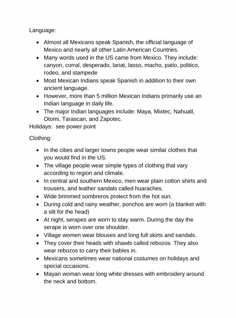
Language:
Almost all Mexicans speak Spanish, the official language of
Mexico and nearly all other Latin American Countries.
Many words used in the US came from Mexico. They include:
canyon, corral, desperado, lariat, lasso, macho, patio, politico,
rodeo, and stampede
Most Mexican Indians speak Spanish in addition to their own
ancient language.
However, more than 5 million Mexican Indians primarily use an
Indian language in daily life.
The major Indian languages include: Maya, Mixtec, Nahuatl,
Otomi, Tarascan, and Zapotec.
Holidays: see power point
Clothing:
In the cities and larger towns people wear similar clothes that
you would find in the US.
The village people wear simple types of clothing that vary
according to region and climate.
In central and southern Mexico, men wear plain cotton shirts and
trousers, and leather sandals called huaraches.
Wide brimmed sombreros protect from the hot sun.
During cold and rainy weather, ponchos are worn (a blanket with
a slit for the head)
At night, serapes are worn to stay warm. During the day the
serape is worn over one shoulder.
Village women wear blouses and long full skirts and sandals.
They cover their heads with shawls called rebozos. They also
wear rebozos to carry their babies in.
Mexicans sometimes wear national costumes on holidays and
special occasions.
Mayan woman wear long white dresses with embroidery around
the neck and bottom.

The men’s special occasion suit is the dark blue charro (made of
velvet) and bolero (short coat)
Women performing the Mexican Hat dance wear a china
poblano dress

LESSON 8
Animals/Recreation/Video
Powerpoint Slides 74-88
Web Graphic Organizer
Recreation:
Soccer is the most popular sport in Mexico
Followed by baseball.
Boys and men can often be found playing soccer in vacant lots
and play on teams in amateur leagues.
Mexico has professional baseball and soccer leagues.
Most Mexicans enjoy watching bullfights. Almost all large cities
have bullrings.
Mexico City has the largest bull ring in the world. It seats about
55,000 people.
Wildlife
VIDEO: Way of Life


LESSON 6: Cultural Craft
AZTEC MOSAIC MASKS
(Where do we use masks and why?)
The detailed craftsmanship of many Aztec masks tells of a society adept at creating and using tools. The uses of masks by the Aztec people show a complex religious structure.
Through the study of these ancient masks we get a remarkable chance to understand the Aztec people themselves.
The Aztecs often designed their masks to represent the face of a deity. The deities Xiuhtecuhtli, Tlaloc, and Tezcatlipoca were found on many of the masks.
Masks bearing the faces of these powerful idols were a key part of many ceremonies.
The Aztecs often used these masks as a part of religious rituals. Some rituals made use of masks as a way to harness the power of beings such as deities, or ancient ancestors. Masks had many different uses, but most were ceremonial. Dancers wore masks, and the masks were sometimes worn by priests as well.
Aztec masks often had complex inlays of precious materials and generally featured a wooden base with decorations. The decorations were sometimes made of turquoise, and shells adorned many of the masks as well.
Mosaics were an important part of the aesthetic of these masks, and most masks featured some kind of mosaic technique. The hours of labor by the Aztec people that went into the creation of their masks help us to understand what an important role the masks played in Aztec culture.
Their masks went out of use with the end of the Aztec civilization itself, but many of the masks may have laid the groundwork for the masks we use today.
Although the Halloween masks we use today are less precious than the masks created by the Aztec people were, masks are still an important part of life today. The profound impact of Aztec masks may have dissipated, but these masks stand as an important reminder of how culture evolves.


MEXICO


Name: ______________________________________________ Unit Test: MEXICO Document-Based Questions
Directions: Use the documents to answer each set of questions. Write your answers in complete
sentences.
Quick Facts About Mexico
Government:
Federal Republic with 3 branches of government
Executive Branch led by the President: President Felipe Calderon (since 2006)
Legislative Branch is called the Congress: Senate and Chamber of Deputies
Judicial Branch: Court System to interpret laws
Mexico has 31 states and 1 federal district
Mexico City is the Capital of Mexico and the oldest city in North America with over 20,500,000 people.
Economy:
Currency: Pesos
Workforce: Service Industries, Agricultural Industries, and Manufacturing Industries
Crops: Corn, Wheat, Beans, Rice, Cotton, Coffee, Lemons, Limes, Avocados, Mangos, and Tomatoes
Livestock: Cattle, Hogs, Chickens, Goats, Turkeys, Horses, Sheep
Mining: Silver, Copper, Gold, Lead, Sulfur, and Zinc
Leading Imports: Products needed to run their factories
Leading Export: Coffee, cotton, silver, oil and oil products, and manufactured goods
1. According to the chart, what is the currency of Mexico?
_________________________________________________________________________________
2. List 2 crops farmed in Mexico.
_________________________________________________________________________________

EARLY MEXICO
The Olmec Indians were the first major civilization to develop by the southern edge of
the Gulf of Mexico. They developed cities and established
trade with other native groups. They developed a calendar
and counting system. They also sculpted massive stone
heads as large as 9 feet tall. They worshipped a God that
was half human and half jaguar. Jade figures and pottery
have been found in the ancient Olmec pyramids.
The Zapotec Indians also settled into southern Mexico.
They were fierce warriors that built great pyramids dedicated to the sun and the moon.
To build one of their pyramids they, as skilled engineers, flattened an entire mountain
top and pulled all the materials for the pyramids and temples up the mountain wall. They
studied the stars and developed the first writing system in the Americas, using
hieroglyphics (word-pictures) to record their history on
stone tablets.
The Mayans built a magnificent civilization stretching from
central Mexico to the Yucatan peninsula. They were a very
intellectual civilization of highly skilled architects, sculptors,
painters, astronomers, and mathematicians. They
designed a calendar more accurate than anything used in anywhere in the world (at that
time). They also devised their own system of math using dots, lines, and shells. The
Mayans were peaceful people who wore jewelry on their ears, lips, nose, and neck. For
some unknown reason the Mayans suddenly abandoned their cities. Vines and weeds
soon covered their temples and their cities remained lost for several centuries.
The Aztec Indians were the late comers to Mexico. They came from the northwestern
part of Mexico. Their legends say they came from a place called Aztlan, the white land,
and it is from there the name Aztec comes from. The Aztecs built the Last and greatest
Indian empire during the mid-1400’s. They built their empire in the middle of a lake.
1. List 2 of the Indian civilizations (described above) and write 1 important fact about each.
a. _______________________________-
__________________________________________________________________________________________________________________
b. _______________________________-
__________________________________________________________________________________________________________________

Culture: Legends, Folklore, and Traditions
The Aztecs had a legend that had been handed down from generation to generation. A
tribal elder had a vision. In his vision he had seen and eagle eating a snake while
perched on a cactus. The Aztecs believed that when they found this symbol they would
make their home there and build their empire. They saw the symbol on an island in the
middle of Lake Texcoco. They drained much of the
lake and built their empire.
This Aztec legend marks the discovery of present day
Mexico City and is represented in the coat of arms on
the Mexican Flag.
The colors on the flag are also significant to the
people of Mexico. Green stands for hope, joy, and
independence. White stands for purity and peace. The
red stands for bravery, strength, valor, and bloodshed from all the hero’s who fought for
their countries independence from Spain.
1. What does the color “white” stand for on the Mexican flag?
______________________________________________________________________
2. When the Aztecs found the symbol (from the vision) what did they do?
______________________________________________________________________
______________________________________________________________________
____________________________________________________________________
______________________________________________________________________