unit 5 frqs question 3: subsistence vs … - question 1: von thunen model of land use 2004 -...
TRANSCRIPT
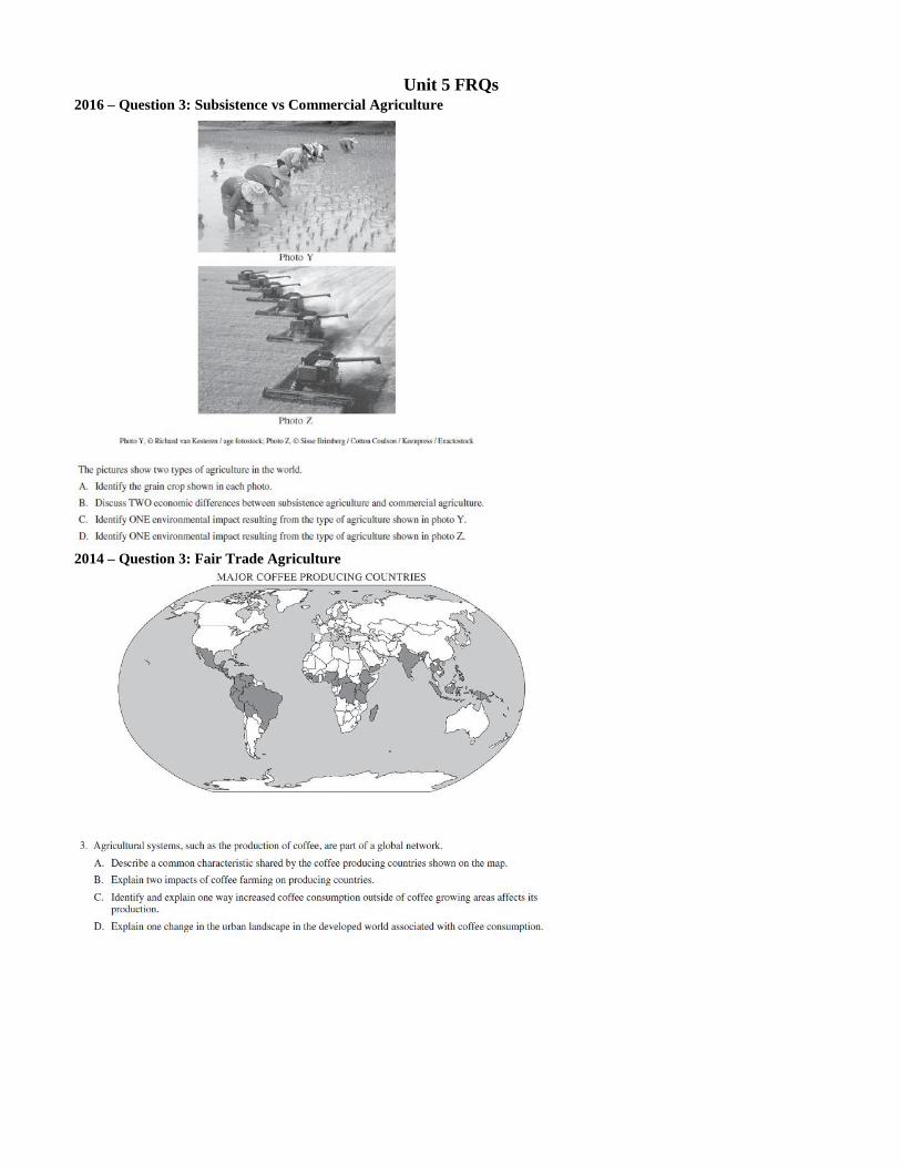
Unit 5 FRQs 2016 – Question 3: Subsistence vs Commercial Agriculture
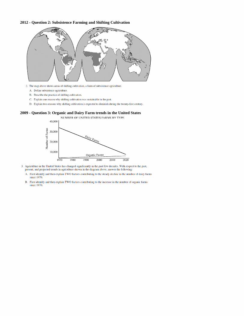
2014 – Question 3: Fair Trade Agriculture
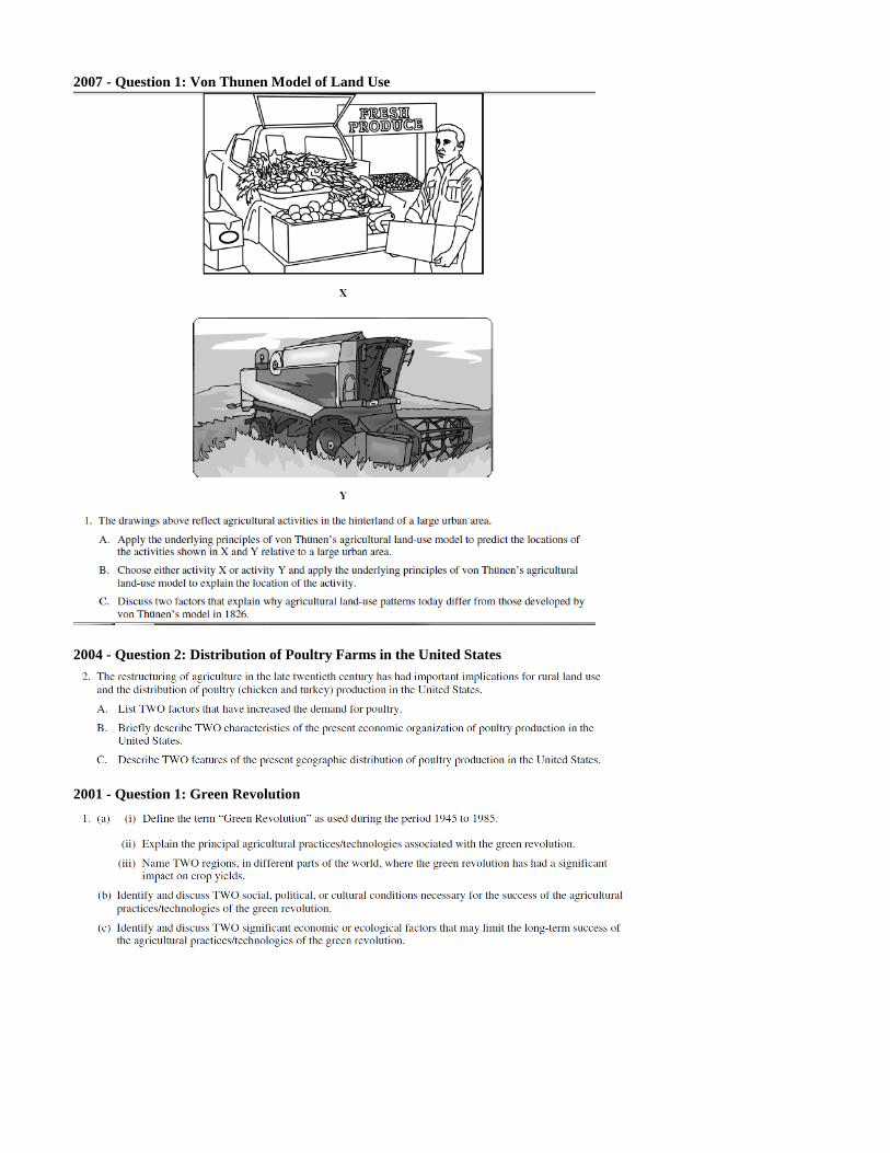
2012 - Question 2: Subsistence Farming and Shifting Cultivation
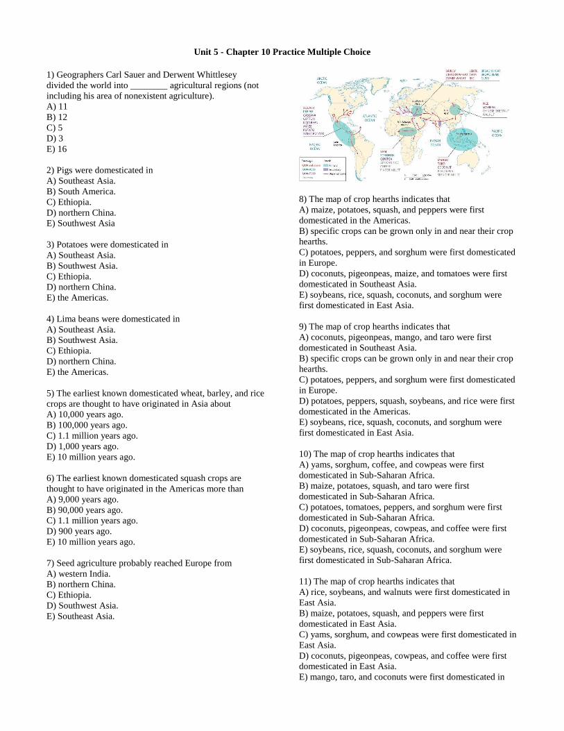
2009 - Question 3: Organic and Dairy Farm trends in the United States
2007 - Question 1: Von Thunen Model of Land Use
2004 - Question 2: Distribution of Poultry Farms in the United States
2001 - Question 1: Green Revolution
Unit 5 - Chapter 10 Practice Multiple Choice
1) Geographers Carl Sauer and Derwent Whittlesey
divided the world into ________ agricultural regions (not
including his area of nonexistent agriculture).
A) 11
B) 12
C) 5
D) 3
E) 16
2) Pigs were domesticated in
A) Southeast Asia.
B) South America.
C) Ethiopia.
D) northern China.
E) Southwest Asia
3) Potatoes were domesticated in
A) Southeast Asia.
B) Southwest Asia.
C) Ethiopia.
D) northern China.
E) the Americas.
4) Lima beans were domesticated in
A) Southeast Asia.
B) Southwest Asia.
C) Ethiopia.
D) northern China.
E) the Americas.
5) The earliest known domesticated wheat, barley, and rice
crops are thought to have originated in Asia about
A) 10,000 years ago.
B) 100,000 years ago.
C) 1.1 million years ago.
D) 1,000 years ago.
E) 10 million years ago.
6) The earliest known domesticated squash crops are
thought to have originated in the Americas more than
A) 9,000 years ago.
B) 90,000 years ago.
C) 1.1 million years ago.
D) 900 years ago.
E) 10 million years ago.
7) Seed agriculture probably reached Europe from
A) western India.
B) northern China.
C) Ethiopia.
D) Southwest Asia.
E) Southeast Asia.
8) The map of crop hearths indicates that
A) maize, potatoes, squash, and peppers were first
domesticated in the Americas.
B) specific crops can be grown only in and near their crop
hearths.
C) potatoes, peppers, and sorghum were first domesticated
in Europe.
D) coconuts, pigeonpeas, maize, and tomatoes were first
domesticated in Southeast Asia.
E) soybeans, rice, squash, coconuts, and sorghum were
first domesticated in East Asia.
9) The map of crop hearths indicates that
A) coconuts, pigeonpeas, mango, and taro were first
domesticated in Southeast Asia.
B) specific crops can be grown only in and near their crop
hearths.
C) potatoes, peppers, and sorghum were first domesticated
in Europe.
D) potatoes, peppers, squash, soybeans, and rice were first
domesticated in the Americas.
E) soybeans, rice, squash, coconuts, and sorghum were
first domesticated in East Asia.
10) The map of crop hearths indicates that
A) yams, sorghum, coffee, and cowpeas were first
domesticated in Sub-Saharan Africa.
B) maize, potatoes, squash, and taro were first
domesticated in Sub-Saharan Africa.
C) potatoes, tomatoes, peppers, and sorghum were first
domesticated in Sub-Saharan Africa.
D) coconuts, pigeonpeas, cowpeas, and coffee were first
domesticated in Sub-Saharan Africa.
E) soybeans, rice, squash, coconuts, and sorghum were
first domesticated in Sub-Saharan Africa.
11) The map of crop hearths indicates that
A) rice, soybeans, and walnuts were first domesticated in
East Asia.
B) maize, potatoes, squash, and peppers were first
domesticated in East Asia.
C) yams, sorghum, and cowpeas were first domesticated in
East Asia.
D) coconuts, pigeonpeas, cowpeas, and coffee were first
domesticated in East Asia.
E) mango, taro, and coconuts were first domesticated in
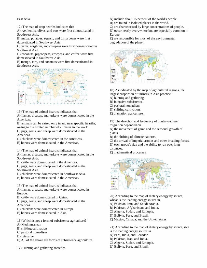
East Asia.
12) The map of crop hearths indicates that
A) rye, lentils, olives, and oats were first domesticated in
Southwest Asia.
B) maize, potatoes, squash, and Lima beans were first
domesticated in Southwest Asia.
C) yams, sorghum, and cowpeas were first domesticated in
Southwest Asia.
D) coconuts, pigeonpeas, cowpeas, and coffee were first
domesticated in Southwest Asia.
E) mango, taro, and coconuts were first domesticated in
Southwest Asia.
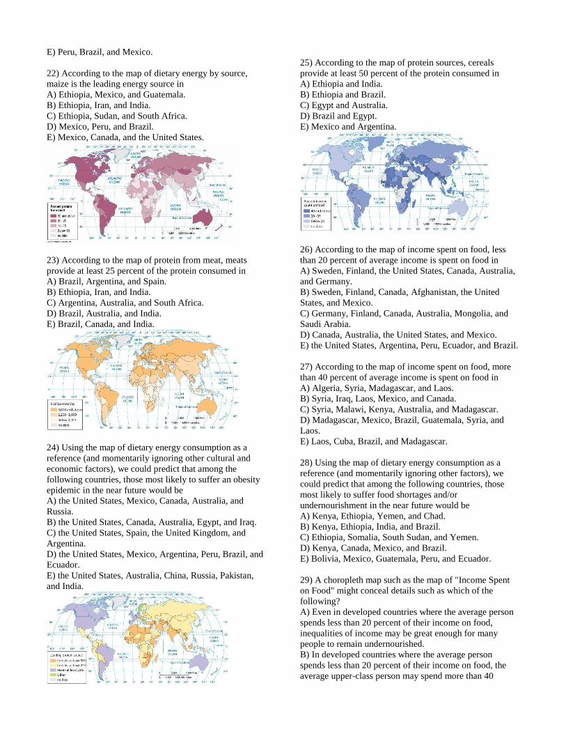
13) The map of animal hearths indicates that
A) llamas, alpacas, and turkeys were domesticated in the
Americas.
B) animals can be raised only in and near specific hearths,
owing to the limited number of climates in the world.
C) pigs, goats, and sheep were domesticated in the
Americas.
D) chickens were domesticated in the Americas.
E) horses were domesticated in the Americas.
14) The map of animal hearths indicates that
A) llamas, alpacas, and turkeys were domesticated in the
Southwest Asia.
B) cattle were domesticated in the Americas.
C) pigs, goats, and sheep were domesticated in the
Southwest Asia.
D) chickens were domesticated in Southwest Asia.
E) horses were domesticated in the Americas.
15) The map of animal hearths indicates that
A) llamas, alpacas, and turkeys were domesticated in
Europe.
B) cattle were domesticated in China.
C) pigs, goats, and sheep were domesticated in the
Americas.
D) chickens were domesticated in Europe.
E) horses were domesticated in Asia.
16) Which is not a form of subsistence agriculture?
A) Mediterranean
B) shifting cultivation
C) pastoral nomadism
D) intensive
E) All of the above are forms of subsistence agriculture.
17) Hunting and gathering societies
A) include about 15 percent of the world's people.
B) are found in isolated places in the world.
C) are characterized by large concentrations of people.
D) occur nearly everywhere but are especially common in
Europe.
E) are responsible for most of the environmental
degradation of the planet.
18) As indicated by the map of agricultural regions, the
largest proportion of farmers in Asia practice
A) hunting and gathering.
B) intensive subsistence.
C) pastoral nomadism.
D) shifting cultivation.
E) plantation agriculture.
19) The direction and frequency of hunter-gatherer
migration depended on
A) the movement of game and the seasonal growth of
plants.
B) the shifting of climate patterns.
C) the arrival of imperial armies and other invading forces.
D) each group's size and the ability to run over long
distances.
E) mathematical processes.
20) According to the map of dietary energy by source,
wheat is the leading energy source in
A) Pakistan, Iran, and Saudi Arabia.
B) Pakistan, Afghanistan, and India.
C) Algeria, Sudan, and Ethiopia.
D) Bolivia, Peru, and Brazil.
E) Mexico, Canada, and the United States.
21) According to the map of dietary energy by source, rice
is the leading energy source in
A) Peru, India, and Ecuador.
B) Pakistan, Iran, and India.
C) Algeria, Sudan, and Ethiopia.
D) Bolivia, Peru, and Brazil.
E) Peru, Brazil, and Mexico.
22) According to the map of dietary energy by source,
maize is the leading energy source in
A) Ethiopia, Mexico, and Guatemala.
B) Ethiopia, Iran, and India.
C) Ethiopia, Sudan, and South Africa.
D) Mexico, Peru, and Brazil.
E) Mexico, Canada, and the United States.
23) According to the map of protein from meat, meats
provide at least 25 percent of the protein consumed in
A) Brazil, Argentina, and Spain.
B) Ethiopia, Iran, and India.
C) Argentina, Australia, and South Africa.
D) Brazil, Australia, and India.
E) Brazil, Canada, and India.
24) Using the map of dietary energy consumption as a
reference (and momentarily ignoring other cultural and
economic factors), we could predict that among the
following countries, those most likely to suffer an obesity
epidemic in the near future would be
A) the United States, Mexico, Canada, Australia, and
Russia.
B) the United States, Canada, Australia, Egypt, and Iraq.
C) the United States, Spain, the United Kingdom, and
Argentina.
D) the United States, Mexico, Argentina, Peru, Brazil, and
Ecuador.
E) the United States, Australia, China, Russia, Pakistan,
and India.
25) According to the map of protein sources, cereals
provide at least 50 percent of the protein consumed in
A) Ethiopia and India.
B) Ethiopia and Brazil.
C) Egypt and Australia.
D) Brazil and Egypt.
E) Mexico and Argentina.
26) According to the map of income spent on food, less
than 20 percent of average income is spent on food in
A) Sweden, Finland, the United States, Canada, Australia,
and Germany.
B) Sweden, Finland, Canada, Afghanistan, the United
States, and Mexico.
C) Germany, Finland, Canada, Australia, Mongolia, and
Saudi Arabia.
D) Canada, Australia, the United States, and Mexico.
E) the United States, Argentina, Peru, Ecuador, and Brazil.
27) According to the map of income spent on food, more
than 40 percent of average income is spent on food in
A) Algeria, Syria, Madagascar, and Laos.
B) Syria, Iraq, Laos, Mexico, and Canada.
C) Syria, Malawi, Kenya, Australia, and Madagascar.
D) Madagascar, Mexico, Brazil, Guatemala, Syria, and
Laos.
E) Laos, Cuba, Brazil, and Madagascar.
28) Using the map of dietary energy consumption as a
reference (and momentarily ignoring other factors), we
could predict that among the following countries, those
most likely to suffer food shortages and/or
undernourishment in the near future would be
A) Kenya, Ethiopia, Yemen, and Chad.
B) Kenya, Ethiopia, India, and Brazil.
C) Ethiopia, Somalia, South Sudan, and Yemen.
D) Kenya, Canada, Mexico, and Brazil.
E) Bolivia, Mexico, Guatemala, Peru, and Ecuador.
29) A choropleth map such as the map of "Income Spent
on Food" might conceal details such as which of the
following?
A) Even in developed countries where the average person
spends less than 20 percent of their income on food,
inequalities of income may be great enough for many
people to remain undernourished.
B) In developed countries where the average person
spends less than 20 percent of their income on food, the
average upper-class person may spend more than 40

percent of their income on food.
C) Even in developed countries where the average person
spends less than 20 percent of their income on food, less
food is available than in developing countries.
D) Even in developing countries where the average person
spends more than 40 percent of their income on food,
wealthy people must also spend more than 40 percent of
their income on food.
E) In developed countries where the average person spends
more than 40 percent of their income on food, other prices
are so low that undernourishment is hardly ever a problem.
30) Which type of agriculture is found primarily in less
developed countries?
A) Mediterranean
B) plantation
C) truck farming
D) commercial gardening
E) mechanized
31) Shifting cultivation is most commonly found in which
climate region?
A) humid low-latitude
B) dry
C) warm mid-latitude
D) cold mid-latitude
E) highlands
32) Which type of agriculture is practiced by the largest
percentage of the world's people?
A) hunting and gathering
B) shifting cultivation
C) pastoral nomadism
D) intensive subsistence
E) plantation
33) Compared to shifting cultivation, intensive subsistence
agriculture is characterized by which of the following?
A) smaller farms
B) lower population densities
C) greater use of animal power
D) more diversified cropping
E) greater use of land in rainforests
34) Which of the following is a typical practice in growing
rice in Asia?
A) preparing fields with a plow drawn by oxen
B) flooding the plowed field with water
C) growing seedlings in a nursery
D) transplanting seedlings into the flooded field
E) All of these answers are correct.
35) The most important reason why most farmers in
northeast China grow crops other than wet rice is
A) cultural preference.
B) tradition.
C) climate.
D) soil.
E) harvesting wet rice requires expensive machinery.
36) Pastoral nomadism is most commonly found in which
climate region?
A) humid low-latitude
B) dry
C) warm mid-latitude
D) cold mid-latitude
E) polar
37) The seasonal migration of livestock between
mountains and lowland pastures is
A) pastoral nomadism.
B) transnomadism.
C) transhumance.
D) practiced mostly in the tropics.
E) livestock ranching.
38) Unlike other forms of commercial agriculture,
plantations are
A) part of agribusiness.
B) owned by day laborers in less developed countries.
C) found primarily in less developed countries.
D) situated in densely populated locations.
E) found primarily in more developed countries.
39) According to the map of agricultural workers, more
than 50 percent of the labor force is engaged in agriculture
in
A) Kenya, Tanzania, and Zimbabwe.
B) Afghanistan, Iran, and Iraq.
C) Kenya, Namibia, and South Africa.
D) Tanzania, Zimbabwe, and Nigeria.
E) Chad, Libya, and Egypt.
40) According to the map of agricultural workers, from 20
to 49 percent of the labor force is engaged in agriculture in
A) Pakistan, Iran, and Algeria.
B) Pakistan, Afghanistan, and India.
C) Algeria, Sudan, and Ethiopia.
D) Bolivia, Peru, and Brazil.
E) Mexico, Canada, and Brazil.
41) According to the map of world rice production,
between 10 and 99 million metric tons of rice are produced
annually in
A) Brazil, Thailand, and the United States.
B) China and India.
C) Iran, Iraq, and Afghanistan.
D) Brazil, Thailand, India, Japan, and China.
E) the United States, China, and India.
42) According to the map of coffee bean production, more
than 100,000 metric tons of coffee beans are harvested
annually in which countries?
A) Brazil, Mexico, Peru, Indonesia, and Ethiopia.
B) China, Ethiopia, Colombia, and India.
C) Iran, Iraq, Colombia, Brazil, and Indonesia.
D) Colombia, Brazil, Thailand, India, Japan, and China.
E) Colombia, the United States, Indonesia, and Ethiopia.
43) Judging from the map of agricultural regions, which
type of agriculture occupies the largest percentage of Iran?
A) mixed crop and livestock
B) pastoral nomadism
C) shifting cultivation
D) intensive subsistence
E) plantation
44) Judging from the map of agricultural regions, which
type of agriculture occupies the largest percentage of
central Africa?
A) mixed crop and livestock
B) shifting cultivation
C) pastoral nomadism
D) intensive subsistence
E) plantation
45) Judging from the map of agricultural regions, which
type of agriculture occupies the largest percentage of
eastern Peru?
A) mixed crop and livestock
B) shifting cultivation
C) pastoral nomadism
D) intensive subsistence
E) plantation
46) Judging from the map of agricultural regions, which
type of agriculture occupies the largest percentage of
Somalia?
A) mixed crop and livestock
B) pastoral nomadism
C) shifting cultivation
D) intensive subsistence
E) plantation
47) Judging from the map of agricultural regions, which
type of agriculture occupies the largest percentage of
southeastern China?
A) mixed crop and livestock
B) intensive subsistence
C) shifting cultivation
D) pastoral nomadism
E) plantation
48) Judging from the map of agricultural regions, which
type of agriculture occupies the largest percentage of
eastern India?
A) mixed crop and livestock
B) intensive subsistence
C) shifting cultivation
D) pastoral nomadism
E) plantation
49) Which of the following have aided commercial
farmers in MDCs?
A) transportation improvements and the rise of sea levels
B) scientific advances, the reduction in the need for
electronics, and
C) ancient irrigation projects that can be refitted for
modern farming
D) transportation improvements, scientific advances, and
electronics
E) climate change, scientific advances, and transportation
improvements
50) The decline in the number of farmers in MDCs can
best be described as a consequence of
A) push/pull economic factors, including the lack of
opportunity in rural areas and higher-paying jobs in urban
areas.
B) urban sprawl, including the development of rings of
suburbs and exurbs around major metropolitan areas,
which required larger amounts of farm production.
C) push/pull economic factors, including greater
opportunities in rural areas and lower-paying jobs in urban
areas.
D) the increase of populations in urban areas and the
reduced population in rural areas.
E) the spread of disease and starvation in rural areas,
which quickly reduced the populations of farmers.
51) The United States had about 60 percent fewer farms
and ________ percent fewer farmers in 2000 than in 1900.
A) 85
B) 52
C) 15
D) 25
E) 99
52) The number of farms in the United States declined
from about 6 million in 1940 to ________ in 1980.

A) 2 million
B) 5.5 million
C) 10 million
D) 1 million
E) 20,000
53) Which of the following is the most common form of
commercial agriculture in Europe?
A) mixed crop and livestock farming
B) dairy farming
C) grain farming
D) livestock ranching
E) Mediterranean agriculture
54) Mixing crops and livestock allows farmers to
A) distribute the workload of the crops and livestock so
that farmers hardly need to work during the summer
season.
B) generate 90 percent of their income from the sale of
livestock.
C) doublecrop.
D) create a system where crops provide food for livestock
and the livestock provide manure for crop fertilization.
E) circumvent market forces that determine the prices of
livestock and crops.
55) After maize, the most important crop in the U.S. mixed
crop and livestock region is
A) wheat.
B) soybeans.
C) barley.
D) fruits and vegetables.
E) sugar beets.
56) In the winter wheat area of the U.S., the crop is planted
in
A) autumn and harvested in summer.
B) winter and harvested in spring.
C) winter and harvested in autumn.
D) spring and harvested in summer.
E) spring and harvested in autumn.
57) Ranching is practiced in a climate region most similar
to that of which other type of agriculture?
A) dairying
B) grain
C) pastoral nomadism
D) shifting cultivation
E) Mediterranean agriculture
58) The different areas of the world where Mediterranean
agriculture predominates have similar
A) climate.
B) cultural beliefs.
C) broad expanses of flat land along sea coasts.
D) social customs.
E) levels of livestock production with the mixed crop and
livestock regions.
59) Which of the following is least likely to be produced in
Mediterranean agriculture?
A) butter
B) fruits
C) grapes
D) olives
E) cereals
60) The predominant form of agriculture in the U.S.
Southeast is
A) mixed crop and livestock.
B) dairy farming.
C) Mediterranean agriculture.
D) commercial gardening.
E) plantation farming.
61) According to the map of world milk production, more
than 100 million metric tons of milk are produced annually
in
A) India.
B) Iraq.
C) Iran.
D) Bolivia.
E) Mexico.
62) According to the map of world milk production, less
than 1 million metric tons of milk are produced annually in
A) Iraq.
B) India.
C) Iran.
D) Peru.
E) Mexico.
63) According to the map of world milk production,
between 1 and 9 million metric tons of milk are produced
annually in
A) Iran.
B) Iraq.
C) Mexico.
D) Libya.
E) Bolivia.
64) Which statement correctly describes hunting and
gathering?
A) All humans began to obtain their food this way after
agriculture was invented.
B) It is a form of nomadism that disappeared in the late
1900s after the fall of the Soviet Union.
C) This form of subsistence disappeared in the mid-1900s
owing to industrialization and modernized agriculture.
D) Hunter gatherers cannot live for long in groups of less
than 100 people owing to the necessary division of labor.
E) This form of subsistence is still practiced despite the
modernization of agriculture in some areas.
65) Which is a characteristic of shifting cultivation?
A) Land is cleared by tractors or large work crews.
B) Debris is mulched to provide the soil with nutrients.
C) A new site is designated every 50 years.
D) Swiddens not under cultivation are used for mining
operations.
E) A new site is designated every few years.
66) Asian agriculture is characterized by shortages of all
but which of the following?
A) equipment
B) funds and land
C) labor
D) land
E) funds
67) Farmers in more developed and less developed
countries share which of the following problems?
A) access to fertilizers
B) inadequate income
C) lack of equipment
D) surplus production
E) the declining importance of world markets
68) Farmers in LDCs choose to grow drug crops for export
primarily because of
A) their market value in MDCs.
B) their proximity to local markets.
C) their inability to grow maize.
D) their disdain for the freedoms enjoyed by developed
countries.
E) their desire to fund terrorist organizations.
69) Afghanistan is important to the world drug trade
primarily because
A) it produces about 90 percent of the world's opium.
B) U.S. troops consume most of the opium grown there.
C) of the inability to grow maize.
D) of the proximity of the Russian market for illicit drugs.
E) of the desire of local farmers to fund terrorist
organizations.
70) The type of agriculture practiced near large cities,
which includes producing fruits and vegetables, is called
A) sawah.
B) truck agriculture.
C) subsistence agriculture.
D) truck farming.
E) truck hybridization.
71) Truck farming is a term that derives from the Middle-
English word truck, meaning
A) "cart."
B) "mobility" or "movement."
C) "subsiding" as in "subsistence agriculture."
D) "bartering" or "exchange of commodities."
E) "horse" or "horse-drawn."
72) In the United States many farms are integrated into a
large food production industry. This is known as
A) agribusiness.
B) commercial farming.
C) food processing.
D) mechanized farming.
E) mixed crop and livestock farming.
73) ________ model is used by geographers to explain the
importance of proximity to the market in the choice of
crops to the commercial farm.
A) von Thünen's
B) Whittlesey's
C) Iqbel's
D) McKinley's
E) von Helsing's
74) The primary factor in von Thünen's model for
choosing commercial farm products is
A) land price.
B) market location.
C) climate.
D) soil character.
E) labor cost.
75) Von Thünen's model can best be used to explain the
location of which of the following types of agriculture?
A) dairying in the Northeast United States
B) ranching in the dry lands of North Africa
C) shifting cultivation in the tropics of South America
D) intensive subsistence in South China
E) mediterranean agriculture in central Chile
76) To increase crop yields, farmers in South China
commonly practice
A) double cropping.
B) transhumance.
C) threshing.
D) pastoral nomadism.
E) shifting cultivation.
77) Which of the following is not a strategy for increasing
food supply?
A) expanding arable land area
B) ensuring sustainable land productivity for future
generations
C) identifying new food sources
D) increasing tariffs on grain exports
E) increasing exports of surplus production

78) According to the graph on the growth in human
consumption of fish, in about the year 2005, the amount of
fish consumed by developing countries exceeded
A) 80 million metric tons.
B) 20 million metric tons.
C) 60 million metric tons.
D) 100 million metric tons.
E) 70 million metric tons.
79) According to the graph on the growth in human
consumption of fish, in about the year 1985, the amount of
fish consumed by developing countries was approximately
A) 40 million metric tons.
B) 35 million metric tons.
C) 50 million metric tons.
D) 55 million metric tons.
E) 60 million metric tons.
80) According to the map of major world fishing regions,
the northwestern Pacific Ocean annually contributes
A) more than 20 million tons of aquatic catch.
B) 10 to 20 million tons of aquatic catch.
C) 5 to 10 million tons of aquatic catch.
D) 1 to 5 million tons of aquatic catch.
E) less than 1 million tons of aquatic catch.
81) According to the map of major world fishing regions,
the Antarctic section of the Pacific Ocean annually
contributes
A) less than 1 million tons of aquatic catch.
B) 10 to 20 million tons of aquatic catch.
C) 5 to 10 million tons of aquatic catch.
D) 1 to 5 million tons of aquatic catch.
E) more than 20 million tons of aquatic catch.
82) According to map of major world fishing regions,
between 10 and 20 million tons of aquatic catch are taken
annually from the
A) northeastern part of the Atlantic Ocean.
B) northwestern part of the Atlantic Ocean.
C) southeastern part of the Atlantic Ocean.
D) Antarctic section of the Atlantic Ocean.
E) eastern central part of the Pacific Ocean.
83) According to the graph on world population and food
production, by the year 2010 the world population was
nearly
A) 11 billion.
B) 6.5 billion.
C) 7.5 billion.
D) 7.3 billion.
E) 7 billion.
84) The best way to block Asian carp from moving into the
Great Lakes from the Illinois River would be the closing of
locks and dams in and near Chicago; however, these
waterways are not being closed because
A) Republicans in the U.S. Congress are concerned about
taxes on the rich.
B) as major transportation links for the region, they are
important for the economy of St. Louis.
C) too many Asian carp are already clogging the locks and
dams and cannot be removed.
D) as major transportation links for the region, they are
important for Chicago's economy.
E) the economies of neighboring states depend on the
Chicago-area locks and dams.
85) In Maryland, soil preservationists produced a new
composite map by combining in their GIS
A) soil quality, environmental, and economic maps.
B) maps on soil quality and proximity to market.
C) dry harvest climate, wet harvest climate, climate
change, and soil maps.
D) maps on habitat for endangered species.
E) soil quality, environmental, and political maps.
86) What is the purpose of crop rotation?
A) maintaining fresh products for market
B) maintaining price supports
C) maintaining the fertility of fields
D) responding to shifting consumer preference
E) reducing transportation costs
87) A principal practice of sustainable agriculture is
A) agribusiness-oriented land management.
B) a "green revolution" in the use of chemicals.
C) the preference for livestock over crops.
D) the use of pesticide-resistant seed.
E) careful land management
88) A major practice of sustainable agriculture is
A) agribusiness.
B) an increased "green revolution" use of chemicals.
C) the lack of integration of crops and livestock.
D) use of pesticide resistant seed.
E) limited use of chemicals
89) Farming varies around the world because of ________
across space.
A) cultural, economic, and environmental factors
B) cultural and economic factors
C) farmers' personal preference and environmental factors
D) weather and climate
E) climate change

Key
1. A
2. E
3. E
4. E
5. A
6. A
7. D
8. A
9. A
10. A
11. A
12. A
13. A
14. C
15. E
16. A
17. B
18. B
19. A
20. A
21. A
22. A
23. A
24. A
25. A
26. A
27. A
28. A
29. A
30. B
31. A
32. D
33. C
34. E
35. C
36. B
37. C
38. C
39. A
40. A
41. A
42. A
43. B
44. B
45. B
46. B
47. B
48. B
49. D
50. A
51. A
52. A
53. A
54. D
55. B
56. A
57. C
58. A
59. A
60. D
61. A
62. A
63. A
64. E
65. E
66. C
67. B
68. A
69. A
70. D
71. D
72. A
73. A
74. B
75. A
76. A
77. D
78. A
79. A
80. A
81. A
82. A
83. E
84. D
85. A
86. C
87. E
88. E
89. A

Unit 5 - Review Questions
1. Identify and give an example of the 5 classifications of economic activity
2. Define agriculture
3. Identify the three countries with the most arable land
4. Differentiate between intensive and extensive agriculture
5. Identify the largest export crop in the world
6. Define the Neolithic revolution and identify two changes that were a result of it.
7. Differentiate between seed and vegetative planting
8. Identify the first domesticated animals as well as their hearths
9. Identify the reasons that lead to seed planting becoming more prevalent
10. Identify origins (hearths) of major seed plants
11. Define the Columbian Exchange and identify two major items that each hemisphere benefited from
12. Explain commodity chain
13. Explain Subsistence Agriculture
14. Explain terraced farming and identify two locations where it could be found
15. Explain Pastoral Nomadism, identify where it is found, and Identify the main types of animals that are raised
16. Explain shifting cultivation, identify where it is found, and identify the main types of crops grown
17. Define intertillage
18. Identify Intensive Subsistence, Wet Rice Dominant and identify where it is found
19. Identify Intensive Subsistence, Wet Rice Not-Dominant, identify where it is found, and identify the main types of
crops grown
20. Explain a commune and identify where they can be found
21. Explain the 2nd agricultural revolution
22. Identify 6 inventions that occurred during this period
23. Define mercantilism
24. Define commercial agriculture
25. Identify and explain the improvement to transportation that have created the success commercial agriculture
26. Explain Plantation Farming, Identify where it is located, and give examples of crops
27. Explain mixed crop and livestock farming, identify where it is located, and give examples of what is produced
28. Explain Dairy Farming, Identify where it is located, and give examples of what is produced
29. Explain Grain Farming, Identify where it is located, and give examples of crops
30. Explain livestock ranching, Identify where it is located, and give examples of what is produced
31. Explain Mediterranean climate agriculture, Identify where it is located, and give examples of crops
32. Explain Commercial gardening/Fruit Farming (truck farming), Identify where it is located, and give examples of crops
33. Explain Von Thunen’s Model
34. Explain the role transportation costs and land rent play in Von Thunen’s model
35. Identify three reasons Von Thunen’s model isn’t applicable in the modern day
36. Identify two reasons Von Thunen’s model is still applicable today
37. Explain a footloose industry and give an example
38. Identify the 5 types of villages
39. Explain the Township-and-Range system
40. Explain the Metes and Bounds Survey system
41. Explain the Long-Long Survey System
42. Define the Third Agricultural Revolution
43. Explain a GMO and Identify major crops and growing locations
44. Identify 4 reasons Africa is slow to adopt GMOs
45. Explain why food manufacturing is considered value added food
46. Define and give examples of sustainable agriculture
47. Explain organic agriculture
48. Define the Eat-Local-Food movement
49. Explain Fair Trade Agriculture
50. Define the Green Revolution
51. Identify two things necessary for the Green Revolution to be successful
52. Identify two criticisms of the Green Revolution

53. Explain the Boserup Thesis
54. Explain the tragedy of the commons
55. Explain desertification as well as the regions were it is a growing concern.
56. Identify were the Sahel region is located
57. Explain overfishing, identify where it is becoming a major problem and identify a solution
58. Explain deforestation and where it is occurring
59. Identify the major drugs being trafficked internationally from hearth to destination
60. Identify two reasons for increases in food prices in the last 10 years and identify the region of the world with extreme
cases of malnutrition
61. Identify and explain two solutions to some of the land use concerns.