unit 1: water erosion and deposition - wordpress.com 50 minute class periods day 1 10 min.- hand out...
TRANSCRIPT

Brad Reiter
EFRT 312
Instructional Planning and Assessment
Unit Plan (Spring 2011)
Unit 1: Water Erosion and Deposition
Identify Desired Results:
-This unit is on water erosion and deposition. By gaining an understanding of the major geologic
forces that help to shape the land will help the students gain an appreciation for the manipulative
power that water has over the land. It is especially important to spend time understanding this
material given Winona’s geologic location.
Major Concepts:
-Water erosion, deposition, and the factors that influence each. There are many different forms of
water erosion and deposition. Understanding these concepts will give the student an idea of how
some of the earth’s topographical formations came to be.
Overall Goal:
-The students should gain an understanding of the manipulative power of water and be able to
identify, as well as differentiate, the different types of water erosion.
Class Description:
-I will be teaching this material to an eighth grade class. The class is composed of eleven of
Winona Middle School’s excelled students and is a mixture of male and female students. The
class period is fifty minutes in length. There is one student with an IEP, but is accompanied by
an aid so there is no need to drastically alter my lesson plan to accommodate him.
Essential Questions
Desired Understanding:
-How does water manipulate the land? (erosion and deposition)
Define as well as compare/contrast erosion and deposition
-What are the different forms of water erosion?
Rill vs. Gully vs. Streams vs. Rivers

-What measures can be taken to help control water erosion in everyday life?
Terracing, waterways, man-made channels, dams, levies, ect.
-What are the economic, geologic, and environmental results of water erosion? (Managed vs.
Unmanaged erosion)
Here I will be looking for connections to be made through their detailed explanations.
Students will know:
-Terminology: erosion, deposition, gulley, rill, channel, stream, river, pond, lake, flood plain,
sediments, ect.
-The economic, geologic, and environmental implications of water erosion.
-The rate of erosion related to the composition of the material being eroded.
Students will be able to:
-Look at a geologic formation and determine if it was shaped by the forces of water erosion
and/or deposition.
-After making a determination, the students should be able to describe in detail the process that
in which water eroded the object or surface.
-List the terminology and definitions that are associated with water erosion and deposition.
Prior Knowledge:
The students will only have the basic knowledge that comes with making everyday observations.
Although I don’t expect the students to know much coming into the class, I will be drawing on
their past experiences in order to relate the material and make it relevant for each student.
Standards:
8.3.1.2.1. Explain how landforms result from the processes of crustal deformation, volcanic
eruptions, weathering, erosion and deposition of sediment.
8.3.1.2.2. Explain the role of weathering, erosion and glacial activity in shaping Minnesota's
current landscape.
8.3.4.1.2. Recognize that land and water use practices affect natural processes and that natural
processes interfere and interact with human systems. For example: Levees change the natural
flooding process of a river. Another example: Agricultural runoff influences natural systems far
from the source.

Determining Acceptable Evidence:
What evidence will be used to determine what students understand?
-This lesson is based on the inquiry model. The students are provided with a packet that contains
about twenty five open ended questions that the students are required to answer as they view the
different types of water erosion and deposition outside. This way they get a chance to get their
ideas and misperceptions on paper where they will later be evident or visible to the student. As
we get into the explain and elaborate stage of the lesson the students are encouraged to make
changes to their packed as they learn the real cause and reasons for what they are witnessing.
This will allow the students to clearly see where their ideas differ from others and make the
necessary changes (students discussion is a form of self-assessment). Being able to see their own
flaws and misperceptions will make for a much more meaningful lesson because they don’t just
have to take my word for it (it will get rid of the idea that the teacher is right “just because” and
give the students a little more pride and ownership of their own work).
-After the class has completed the lab activity and discussed the formations witnessed, they were
given a book assignment that had them answer four open ended questions that are testing their
thinking skills because they require a higher order of thinking and are somewhat hypothetical.
The rest of the assignment deals with the vocabulary introduced in the lesson because they have
to be able to tell me the definitions of each word.
-For my final assessment I have rolled the three categories of (quiz, prompt, and skill check) into
one test. The test was one question long, but required a great amount of detail, depth, and
explanation to receive full credit. Since the lesson involved visiting seven sites where there was
evidence of different types of erosion and deposition taking place, I asked the students, “to
describe the erosion at each waypoint using the vocabulary and provide a detailed description of
how that erosion took place”. I gave them the list of seventeen vocabulary words and required
that at least ten of the words be used in their explanation of the sites.
This assessment will show me their depth of knowledge while empowering the students to decide
how they show their knowledge. I have found that students are much more attentive and engaged
when given the choice or opportunity to make a choice. They didn’t know ahead of time that
they only had to use ten out of the seventeen vocabulary words in their explanation so they had
to learn them all.
Objectives:
1.) From this field experience the students will develop a thorough understanding, and
hopefully a fascination, of water erosion and deposition.
2.) Students will understand the vocabulary terms and be able to use at least ten out of
seventeen terms in their exam answers.
3.) The students will be able to verbally discuss and explain, correctly, the type of erosion
that is taking place at each waypoint.
4.) Students will learn how to operate and navigate using a handheld GPS unit in the field.
5.) Since this lesson uses the inquiry method of teaching, the students will learn to be
comfortable and share their ideas with one another in the field. From the sharing of ideas,
it is expected that most of the students will be able to deduce the right conclusion.
Studies have shown that students that can teach information to one another have a
retention rate of nearly 90%
Instructional Strategies:
In this lesson there are many strategies employed to help students of all cognition levels
learn and retain the material.
Visual
For the visual learner I provided pictures (cross section of a stream, levee, delta, meander) in
order to elaborate on the specific details that might not be very evident to the students. A good
example of this is the cross section of the stream. If it has recently rained the river will most
likely be muddy and the students will have a hard time seeing what is on the stream bed.
Contextual
The contextual learner should enjoy this lesson. The lesson is in the form of an outside field
experience. The students will be searching out seven waypoints using GPS devices while
answering prompting questions in a handout. The students is out doors and surrounded by
examples of water erosion and deposition, giving the contextual learner a lasting experience.
Verbal/Auditory
Although I put these two techniques together, I believe them to be very different. The verbal
instructional technique provides information through spoken works. The students are encouraged
and even prompted to discuss their findings at each waypoint with classmates. This will not only
help the verbal learner, but all students since they are discussing the information and coming to
their own conclusions. (Some guidance may be required by teacher)
The auditory aspect of this lesson is very different than the verbal in the sense that the kids are
outside and can hear the differences of the stream at different locations. This will help the

students connect the concept of how the speed of the water influences erosion. For example; the
loud roar of the water crashing into the ground at the base of a waterfall, the rushing sound of
fast flowing rapids, or the babbling of a brook.
Kinesthetic
Means that the students get a chance to feel for themselves how characteristics differ from one
waypoint to another. Not only were the students able to experience the real deal by being outside,
but they got the chance to engulf themselves in the subject. The students were allowed to go
down by the river and poke around the bottom of the river as well as feel the difference in the
sediments at different waypoints. I believe this to be a great way to help my kinesthetic learners
connect concepts and retain information.
Textual
The students are given a handout that gives them some direction by asking prompting, open
ended questions. This is a big part of the inquiry strategy because the open ended questions in the
packet will bring the students misperceptions to light. After the students have visited and
discussed every waypoint with each other, the teacher will bring the class together and distribute
another handout. The handout has vocabulary terms and definitions as well as pictures to help
with the formal discussion. As the teacher goes through the packet with the students, he/she will
connect the terms with what was witnessed in the field. The pictures help the teacher further
explain the characteristics of a river that weren’t easily observed.
Transitions:
This is a designed to be a three day lesson so there will be no way that the field
experience will be completed in one day. In this lesson the students are encouraged to work at
their own pace to ensure that they are making thorough observations, but the teacher may have to
keep students on task. The first day, the lesson is introduced and the students should make it
through the first three waypoints. The first three waypoints focus on different types of rill erosion
as well as sheet erosion. The second day the students will be visiting a stream, pond, and lake,
where they will observe stream erosion and deposition. I provided a wide variety of examples of
water erosion in order to help the students see the diverse effects it has on the surrounding
landscape in different settings and on different scales.
In the packet I ask the students to be looking for signs of chemical or mechanical erosion
caused by water as they walk from one way point to another. This will only further help connect
ideas and concepts about chemical and physical water weathering.

Timeline: 50 minute class periods
Day 1 10 min.- Hand out and briefly explain the project
30 min.- Investigate waypoints 1-3
10 min.- Go back to room and briefly discuss the major characteristics of water erosion
witnessed
Day 2 5 min.- Review goal, get GPS and other materials
35 min.- Walk to and observe waypoints 4-7
10 min.- Briefly discuss major characteristics of water erosion witnessed
Day 3 5 min.- Review goal of project (where did we end the day before?)
35 min.- Go over and discuss the packet as a class (teacher led)
10 min.- Explain and administer homework
Materials Needed
-GPS -Good attitude
-Clipboard - Critical Thinking Skills
-pencil
-packet

How Does Water Shape our Lives?
Engage: What factors contribute to the different types of water erosion
and how?
Before Studying this Unit After Studying this Unit
Explore/Explain: Make your way to each way point on your GPS. Answer the
questions and make observations about the different types of water erosion that is
taking place.
Waypoint 1: On the wall of the school you will find a drainage spout for rainwater
that collects on the roof.
>Describe what is happening as a result of the drainage spout.
>What are the factors responsible for this type of erosion? (List as many as you can)

>Can you think of any natural settings where you would find this type of erosion?
Waypoint 2: Here you will find a type of erosion taking place on the ground next
to the retaining wall.
>Describe what you see here and how it differs from waypoint 1. (be detailed
enough so we can talk about it later in the classroom)
>What different factors are responsible for this type of erosion?
>Can you think of any other instances where this type of erosion might take place?
Waypoint 3: Look alone the road where the pavement meets the soil.
>Describe the type of erosion that is taking place.

>What different factors are responsible for this type of erosion?
>Where else could you see water erosion like this?
Waypoint 4: Pond
>What would you expect to find on the bottom? Explain why.
>How did it get there?
*as you walk from waypoint 4 to waypoint 5 look for examples of water erosion
and record them.
Waypoint 5: Stream
>What do you notice about the stream where there is restricted flow?

>Describe the stream and sediments where the water is shallow.
>Describe the stream and sediments where the water is deep.
>Notice how high the flood waters reached already this year. How might the
increase in the volume of water effect the surrounding area?
Waypoint 6: Stream
>What do you notice about the banks on either side of the stream? How are they
different?

> How is water erosion responsible for these differences?
>Compare and Contrast where the stream is straight to where the stream has a bend
in it. Make sure to look at all aspects of the stream. (flow, depth, sediments, banks,
ect.)
Compare Contrast

Waypoint 7: Lake
>Where is there evidence of water erosion?
>How did this type of erosion take place?
>If you were to jump in, what would you find on the bottom? Why?
*As you make your way around the lake look for evidence of chemical weathering
caused by water. (Record your observations below)

Elaborate
The teacher has a couple of options based on the weather and progress of the class. If the weather
is nice the teacher has the choice to go over the answers in the field. This allows the teacher to
clarify any misconceptions by revisiting the waypoint and pointing out exact characteristics that
you want your students to see and understand. If the weather is not nice, the teacher has to choice
of going over the packet in the classroom. Each setting has its advantages and disadvantages, the
choice should be made based on the maturity and work ethic of your class.
In reviewing the packet, it is the teacher’s job to facilitate the discussion and clarify any
misperceptions that the students may have about a specific waypoint or concept. It is very
important to let the students express their ideas to give them a sense of ownership. You should
find that most of the students will be on the right track and understand most of the concepts.
The students will be provided with a two page handout that has seventeen terms that they should
know, along with the definitions, and four pictures that show important characteristics of a
streams and erosion that might not be clear in the field experience. (provided below)
The teacher will talk about and explain each term and its relevance as it pertains to the field
experience and water erosion.
Water Erosion Handout
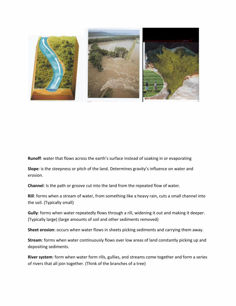
Runoff: water that flows across the earth’s surface instead of soaking in or evaporating
Slope: is the steepness or pitch of the land. Determines gravity’s influence on water and
erosion.
Channel: Is the path or groove cut into the land from the repeated flow of water.
Rill: forms when a stream of water, from something like a heavy rain, cuts a small channel into
the soil. (Typically small)
Gully: forms when water repeatedly flows through a rill, widening it out and making it deeper.
(Typically large) (large amounts of soil and other sediments removed)
Sheet erosion: occurs when water flows in sheets picking sediments and carrying them away.
Stream: forms when water continuously flows over low areas of land constantly picking up and
depositing sediments.
River system: form when water form rills, gullies, and streams come together and form a series
of rivers that all join together. (Think of the branches of a tree)

Drainage Basin: Is the area of land where all of the runoff in comes together. We are part of the
Mississippi River Drainage Basin.
Young Stream: A stream that flows swiftly through a steep valley. Characteristics: high sides,
rough bottom, fast current, rapids, erosion concentrated on bottom
Mature Stream: Flows more smoothly through its valley or channel, erosion is concentrated
along the sides, smoother and finer sediments found on bottom compared to a young stream
Old Stream: flows slowly and smoothly along a wide flat surface. Found where the river comes
to an end.
Meander: is a curve in a river that was formed by the fast current eroding one bank more than
the other. Usually created in the mature stage of stream development.
Flood Plain: is the broad flat valley floor formed by a meandering stream. Area is effected when
water level is very high
Dams: built to control the flow of water in a river or stream
Levees: built to keep water out of an area in times of high water
Delta/Fans: are where rivers come to an end. Form where streams or rivers enter an ocean or
lake. They wide shallow areas where the water slows and deposits its sediments.
Evaluate
There will be two forms of evaluation administered that will test the student’s knowledge on the
subject of water erosion and deposition.
I. Will be assigned homework out of the book
II. Will be in the form of an essay style exam.
I.) Homework

Name:_______________
Read pages 238-248 and answer the following questions.
1.) The city of New Orleans is built on a part of the Mississippi River delta where sediments
are compacting. As a result, the city and surrounding area are sinking, and the city is
actually below sea level. To protect it from flooding, levees have been built along the
river banks. What fairly recent disaster took place in New Orleans in 2005? What was the
cause of this disaster and how was erosion responsible?
2.) Now that you know the difference between the three stages of stream development,
answer the following questions.
-Which stage stream would be most likely to have a gravel streambed? Why?
-Why do old streams drop their loads of sediment near their mouths?
-Where is the water flow the fastest in a meander? How do you know this?

II.) Exam
- This exam is aimed at developing higher order thinking skills because it
requires the students to relate concepts and describe them in a natural,
observable setting. Since this exam requires the use of in depth thought and
recollection of specific events at each waypoint, the students are allowed to
use their notes during the test. Cheating is not a concern on this test since it
requires the students to describe their observations and their own application
of concepts.
Name_____________________
Water Erosion and Deposition Exam Describe the erosion at each waypoint using the vocabulary and provide a detailed
description of how that erosion took place. (use at least 10 out of the 17 vocabulary
words)
Vocabulary: runoff, slope, channel, rill, gully, sheet erosion, stream, river system,
drainage basin, young stream, mature stream, old stream, meander, flood plain, dams,
levees, delta