unit 1: how do the ocean and atmosphere...
TRANSCRIPT

50 • Ocean Sciences Sequence 6–8
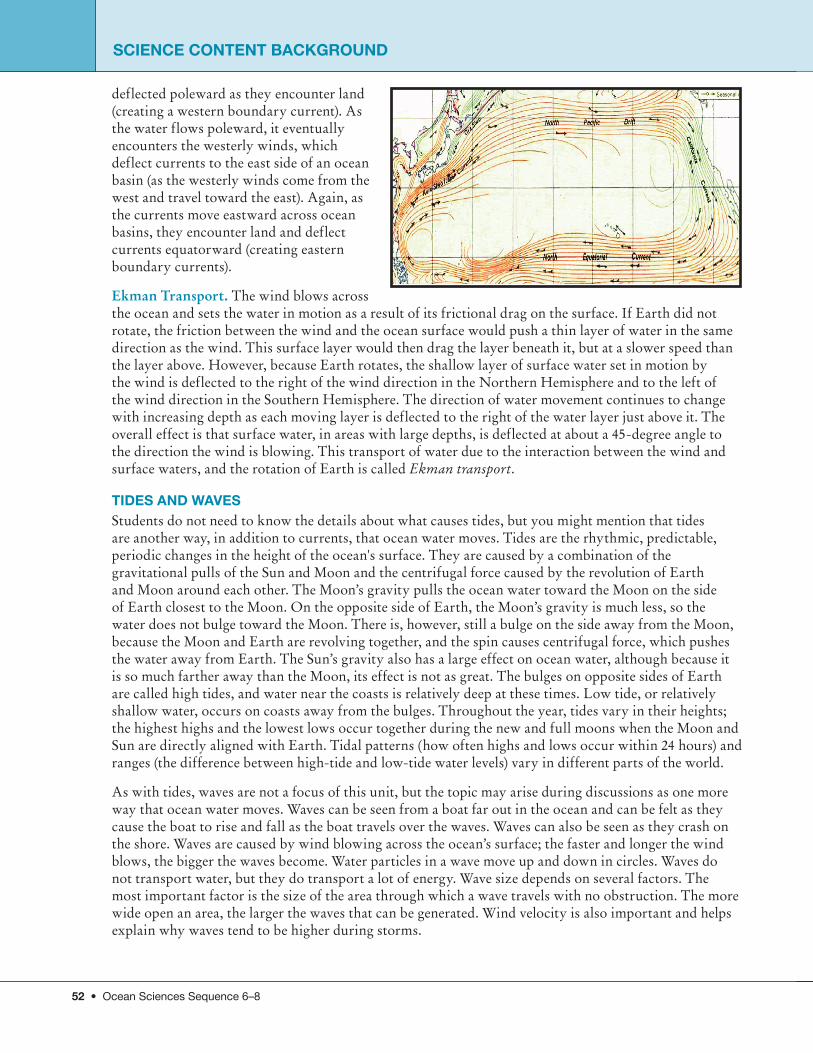
UNIT 1: how Do the Ocean and Atmosphere Interact?The Ocean in motionOCEAN CURRENTSOcean circulation is very complex. It is made up of a global network of ocean currents that move due to wind, the uneven heating of Earth, Earth ’s rotation, how water flows around the continents, density differences of water based on salinity (saltiness), and on temperature differences in different places. Much of the movement of ocean water is a result of the ocean and atmosphere working together to move heat around the globe, with warmer water moving from the equator toward the poles and colder water flowing from the poles back toward the equator.
Ocean currents are huge amounts of seawater moving fairly steadily in a relatively constant direction over long distances, much like rivers within the ocean. The strongest ocean currents flow near the surface and are primarily caused by wind. These currents flow through the upper layers of the ocean and are ultimately driven by heat energy from the sun. Wind-driven surface currents have been known for centuries by Polynesian navigators and Chinese, European, American, and many other sailors from around the world. Sailors found they could shorten their voyages by months if they followed favorable currents.
There are also important currents in the ocean that move water throughout the lower layers. These currents are only partly caused by the wind; mainly, they are caused by variations in salinity and temperature in different parts of the ocean. Saltier water is denser than freshwater, and cold water is denser than warm water. Denser water tends to sink, and water that is less dense tends to rise. Therefore, density differences can cause vertical currents. These are important currents because they bring deep ocean water to the surface and move surface water downward. This type of circulation due to temperature and salinity is called thermohaline circulation.
Scientists often classify ocean currents into three major types, each driven by different forces that occur on very different time and spatial scales. These are (1) wind-driven surface currents occurring over a short-term time scale and 50–100 m deep; (2) oceanic gyres or current systems occuring over a longer term, 500–2,000 m deep and ranging over entire hemispheres or ocean basins (see below for more about gyres); and (3) the Great Ocean Conveyor Belt, a very long term (1,000 years) and wide-ranging global thermohaline current flowing from the surface to the deepest part of the ocean across the entire globe (see Great Ocean Conveyor Belt). A convection current is any circular current caused by differences in temperature. Many large systems of air currents and the Great Ocean Conveyor Belt can be considered to be convection currents.
WINDS RESUlT FROm ThE UNEvEN hEATING OF EARTh Winds are driven by heat energy from the Sun and result from the Sun heating Earth unevenly. At the equator, sunlight strikes Earth at a 90-degree angle each day. At the poles, sunlight strikes Earth at such a low angle that the energy is very spread out. More energy from sunlight is absorbed near the equator,
so in general, the closer a location is to the equator (and the farther it is from a pole), the warmer the location. As the air at the equator warms, it becomes less dense and starts to rise. Winds form as air flows in from other places to replace the rising air. Winds don’t move straight toward the equator, but instead form at an angle to the direction of the wind due to friction (see Ekman Transport) and Earth’s rotation (see Coriolis Effect). These winds approaching the equator from the north and south at an angle of about
Tradewinds Ocean Currents
GREENLAND
L ABRADOR
GULF STREAM
NORTH ATLAN
TIC
FLO
RIDA
CANAR
Y
NORTH EQUATORIAL
EQ
UATORIAL COUNTERGUINEASOUTH EQUATORIAL
BRAZIL
BE NGUELA
FALKLAND
WESTWIND DRIFT
WESTWIND DRIFT
CAPE HORN
EAST.A
USTRALIAN
WESTWIND DRIFT
WESTAU
STRALI
AN
SOUTHEQUA
TORIAL
EQUATORIAL COUNTER
NORTH EQUATORIAL
JAPAN
KA
MCHATKA
ALASKA
CALIFORN
IA
OY
ASHIO
PERU
AGULHA
S
SOUTH EQUATORIAL
EQUATORIAL COUNTER
SOUTH EQ
UATOR IAL
NORTH EQUATORIAL
WESTWIND
DRIFT
Ocean Currents and Tradewinds
SCIENCE CONTENT bACKGROUND

Ocean Sciences Sequence 6–8 • 51
somethingSCIENCE CONTENT bACKGROUND
45 degrees are called trade winds and are considered to be the steadiest winds on Earth. The rising of warm air and the sinking of cold air create the other major wind patterns on Earth.
ThE GREAT OCEAN CONvEyOR bElT The Great Ocean Conveyor Belt is a global pattern of ocean circulation driven by density differences that moves water from surface currents down to deep water currents, and then back to the surface again. This global pattern of circulation mixes the ocean on a timescale of about 1,000 years. The circulation starts when surface water becomes very dense and sinks to the bottom. This occurs at only a few locations, mainly in the North Atlantic, southeast of Greenland, and near Antarctica. Once the water sinks, it spreads throughout the Atlantic and into the other ocean basins. The water eventually comes back up to the surface and flows back to the Atlantic. And the circulation starts again. This global pattern is critical to regulate climate, and it is thought that alterations in the conveyor belt system have produced rapid climate changes in the past.
FACTORS AFFECTING DIRECTION OF OCEAN SURFACE CURRENTSThe direction that ocean currents flow is controlled by a number of natural forces. The Coriolis effect, caused by Earth’s rotation, makes currents form clockwise circulations in the Northern Hemisphere and counterclockwise circulations in the Southern Hemisphere. Friction between air and the ocean’s surface, and between different layers of water makes ocean currents flow, in general, at an angle to the direction of the wind (see Ekman Transport). Interactions with land masses also affect the direction of ocean surface currents, the deflection of ocean water off continents causes surface currents to form into large gyres in many ocean basins.
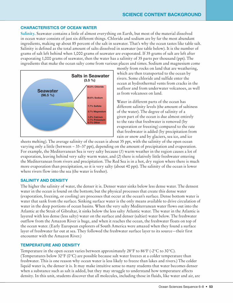
The Coriolis Effect. The Coriolis effect results from the rotation of Earth. It is one of the factors involved in creating the major ocean currents that spin clockwise in the Northern Hemisphere and counterclockwise in the Southern Hemisphere. These current systems are called gyres. The Coriolis effect was first described in the early 19th century. It was known that an object that moves in a straight line above the surface of Earth will appear to curve when viewed by people on Earth, because Earth is rotating under it. Movement in the Northern Hemisphere is diverted to the right (if we look in the direction that the object is moving) and to the left in the Southern Hemisphere. This effect is also seen in the atmosphere, causing winds around high-pressure systems to rotate clockwise around the center in the Northern Hemisphere and counterclockwise in the Southern Hemisphere
(In this unit, students do not need to know about the Coriolis effect; they only need to understand that currents flow in predictable patterns.)
Gyres and Interactions with Land Masses. The Coriolis effect deflects objects in the Northern Hemisphere off their trajectories toward the right (to the left in the Southern Hemisphere), due to the rotation of Earth. This factor, in combination with another phenomenon called Ekman transport (water moves at an angle from the direction of the wind because of friction), and the location of the land masses, results in major ocean gyres. In each ocean basin, the westward-flowing equatorial currents are
NORTHERN HEMISPHERE
SOUTHERN HEMISPHERE
CORIOLIS EFFECTCAUSED BY THE EARTH'S ROTATION
Objects deflect tothe right in the
Northern Hemisphere
Objects deflect tothe left in the
Southern Hemisphere
The deflection of moving objectsrelative to an observer on the Earth.
WIN
D F
RO
M N
OR
TH
UPWELLINGalong a west coast in the Northern Hemisphere
EQUATORIAL UPWELLINGN
Meteorological Equator
GeographicalEquator
Upwelling
Equatorial Undercurrent
100 m
SOUTHEAST TRADE WINDS
South Equatorial Current
52 • Ocean Sciences Sequence 6–8
deflected poleward as they encounter land (creating a western boundary current). As the water flows poleward, it eventually encounters the westerly winds, which deflect currents to the east side of an ocean basin (as the westerly winds come from the west and travel toward the east). Again, as the currents move eastward across ocean basins, they encounter land and deflect currents equatorward (creating eastern boundary currents).
Ekman Transport. The wind blows across the ocean and sets the water in motion as a result of its frictional drag on the surface. If Earth did not rotate, the friction between the wind and the ocean surface would push a thin layer of water in the same direction as the wind. This surface layer would then drag the layer beneath it, but at a slower speed than the layer above. However, because Earth rotates, the shallow layer of surface water set in motion by the wind is deflected to the right of the wind direction in the Northern Hemisphere and to the left of the wind direction in the Southern Hemisphere. The direction of water movement continues to change with increasing depth as each moving layer is deflected to the right of the water layer just above it. The overall effect is that surface water, in areas with large depths, is deflected at about a 45-degree angle to the direction the wind is blowing. This transport of water due to the interaction between the wind and surface waters, and the rotation of Earth is called Ekman transport.
TIDES AND WAvESStudents do not need to know the details about what causes tides, but you might mention that tides are another way, in addition to currents, that ocean water moves. Tides are the rhythmic, predictable, periodic changes in the height of the ocean's surface. They are caused by a combination of the gravitational pulls of the Sun and Moon and the centrifugal force caused by the revolution of Earth and Moon around each other. The Moon’s gravity pulls the ocean water toward the Moon on the side of Earth closest to the Moon. On the opposite side of Earth, the Moon’s gravity is much less, so the water does not bulge toward the Moon. There is, however, still a bulge on the side away from the Moon, because the Moon and Earth are revolving together, and the spin causes centrifugal force, which pushes the water away from Earth. The Sun’s gravity also has a large effect on ocean water, although because it is so much farther away than the Moon, its effect is not as great. The bulges on opposite sides of Earth are called high tides, and water near the coasts is relatively deep at these times. Low tide, or relatively shallow water, occurs on coasts away from the bulges. Throughout the year, tides vary in their heights; the highest highs and the lowest lows occur together during the new and full moons when the Moon and Sun are directly aligned with Earth. Tidal patterns (how often highs and lows occur within 24 hours) and ranges (the difference between high-tide and low-tide water levels) vary in different parts of the world.
As with tides, waves are not a focus of this unit, but the topic may arise during discussions as one more way that ocean water moves. Waves can be seen from a boat far out in the ocean and can be felt as they cause the boat to rise and fall as the boat travels over the waves. Waves can also be seen as they crash on the shore. Waves are caused by wind blowing across the ocean’s surface; the faster and longer the wind blows, the bigger the waves become. Water particles in a wave move up and down in circles. Waves do not transport water, but they do transport a lot of energy. Wave size depends on several factors. The most important factor is the size of the area through which a wave travels with no obstruction. The more wide open an area, the larger the waves that can be generated. Wind velocity is also important and helps explain why waves tend to be higher during storms.
SCIENCE CONTENT bACKGROUND
Ocean Sciences Sequence 6–8 • 53
somethingSCIENCE CONTENT bACKGROUND
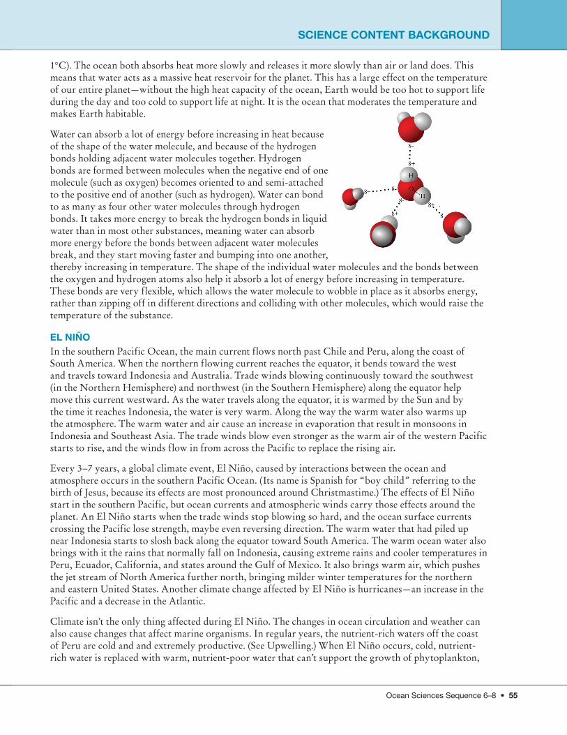
ChARACTERISTICS OF OCEAN WATERSalinity. Seawater contains a little of almost everything on Earth, but most of the material dissolved in ocean water consists of just six different things. Chloride and sodium are by far the most abundant ingredients, making up about 85 percent of the salt in seawater. That’s why the ocean tastes like table salt. Salinity is defined as the total amount of salts dissolved in seawater (see table below). It is the number of grams of salt left behind when 1,000 grams of seawater are evaporated. If 35 grams of salt are left after evaporating 1,000 grams of seawater, then the water has a salinity of 35 parts per thousand (ppt). The ingredients that make the ocean salty come from various places and times. Sodium and magnesium come
mostly from rocks on land that are weathering, which are then transported to the ocean by rivers. Some chloride and sulfide enter the ocean at hydrothermal vents from cracks in the seafloor and from underwater volcanoes, as well as from volcanoes on land.
Water in different parts of the ocean has different salinity levels (the amount of saltiness of the water). The degree of salinity of a given part of the ocean is due almost entirely to the rate that freshwater is removed (by evaporation or freezing) compared to the rate that freshwater is added (by precipitation from rain or snow and by glaciers, sea ice, and ice
sheets melting). The average salinity of the ocean is about 35 ppt, with the salinity of the open ocean varying only a little (between ~ 33–37 ppt), depending on the amount of precipitation and evaporation. For example, the Mediterranean Sea is very salty because (1) warm weather in the region causes a lot of evaporation, leaving behind very salty warm water, and (2) there is relatively little freshwater entering the Mediterranean from rivers and precipitation. The Red Sea is in a hot, dry region where there is much more evaporation than precipitation, so it is very salty (about 40 ppt). The salinity of the ocean is lower where rivers flow into the sea (the water is fresher).
SAlINITy AND DENSITy The higher the salinity of water, the denser it is. Denser water sinks below less dense water. The densest water in the ocean is found on the bottom; but the physical processes that create this dense water (evaporation, freezing, or cooling) are processes that occur at the ocean’s surface. Dense bottom water is water that sank from the surface. Sinking surface water is the only means available to drive circulation of water in the deep portions of ocean basins. When the very salty Mediterranean water flows out into the Atlantic at the Strait of Gibraltar, it sinks below the less salty Atlantic water. The water in the Atlantic is layered with less dense (less salty) water on the surface and denser (saltier) water below. The freshwater outflow from the Amazon River is huge, and when it reaches the ocean, the freshwater floats on top of the ocean water. (Early European explorers of South America were amazed when they found a surface layer of freshwater far out at sea. They followed the freshwater surface layer to its source—their first encounter with the Amazon River.)
TEmPERATURE AND DENSITyTemperature in the open ocean varies between approximately 28°F to 86°F (-2°C to 30°C). (Temperatures below 32°F (0°C) are possible because salt water freezes at a colder temperature than freshwater. This is one reason why ocean water is less likely to freeze than lakes and rivers.) The colder liquid water is, the denser it is. It may make intuitive sense to many students that water becomes denser when a substance such as salt is added, but they may struggle to understand how temperature affects density. In this unit, students discover that all molecules, including those in fluids, like water and air, are
Seawater
Salts in Seawater
(96.5 %)
(3.5 %)55.0% Chloride
30.6% Sodium
7.7% Sulfate
3.7% magnesium
1.2% Calcium 1.1% Potassium 0.7% Other
Seawater
Salts in Seawater

54 • Ocean Sciences Sequence 6–8
always moving. As these molecules move, they bump into one another and push each other away. This causes the particles to spread out and take up more space—they fill a larger volume. The warmer the liquid, the faster the molecules move, the more they hit one another, the more space between, and that means the liquid is less dense. Particles in cold water move less and bump into each other with less force, so they are more tightly packed together, making the liquid more dense. This discussion relates to kinetic theory.
DENSITy AND lAyERS OF OCEAN WATERWater masses with different densities (caused by differences in salinity and/or temperature) do not mix easily when they meet, but instead flow above or beneath one another. These differences can last a very long time—up to 1,600 years in some cases! This layering means that there may be several different habitats in which organisms can live in one vertical column of water. The upper layers of the ocean are where plantlike organisms (phytoplankton, including algae and bacteria) live, because they need sunlight. The fertilizer or nutrients from dead, decomposing organisms needed for growth sink toward the bottom and collect in the deeper, colder, denser water. If these nutrient-rich waters are brought back to the surface through upward-flowing currents (upwelling), they can create areas rich with life. Although layers in the ocean may sometimes last a long time, mixing between the layers does occur. If surface water becomes denser (for example, by cooling), it will sink, and less dense water will rise to the surface. These currents can then cause mixing between the layers. Mixing by waves also occurs, especially during large storms.
There are many thin layers of water organized horizontally in the ocean, each with a slightly different density due to salinity and temperature. These many thin layers can be classified into three main layers: (1) The uppermost surface layer—about 100–200 meters thick, well mixed by wind, waves, and currents. Sometimes this layer gets heated by the Sun, and warm water floats on top with cooler water below. (2) The intermediate layer—below the surface layer, to a depth of approximately 1,000–1,500 meters, temperature decreases with increasing depth. (3) The deepest layer—most uniformly cold layer of water, usually less than 39°F (4°C), found below the intermediate layer.
CURRENTS AND ClImATEOcean currents profoundly affect weather and climate. For example, the Gulf Stream, North Atlantic, and Norway Currents bring warm tropical waters from near the Bahamas northward and eastward, warming the climates of eastern North America, the British Isles, and Ireland, as well as the Atlantic coast of Norway in winter. The Kuroshio Current and the North Pacific Current do the same for Japan and western North America, where warmer winter climates also result. The warmer waters also evaporate more readily in the warmer temperatures and help generate increasing rain and snowfall along these coasts.
On the other hand, the cold Peru, California, and Benguela Currents hinder evaporation and, as they flow along the coasts of southern California, western South America, and southwest Africa, they create fog but no rain, resulting in the deserts of California, Peru, Chile, and Namibia. These cold currents are fed, in part, by cold waters welling up from deep in the ocean. Ocean currents and atmospheric circulation influence each other. For example, periodically, the trade winds above the tropical Pacific weaken and the eastern tropical Pacific waters are warmed, creating an El Niño event (see El Niño). This event widely affects climate and weather, bringing drought to Australia, more winter storms to southern California, and a warm winter to northern North America.
ThE OCEAN SERvES AS EARTh’S hEAT RESERvOIR AND mODERATES EARTh’S ClImATE Water can absorb a lot of heat with a relatively small increase in temperature; this means it has a very high heat capacity (the amount of heat energy needed to raise the temperature of one gram of a substance
SCIENCE CONTENT bACKGROUND
Ocean Sciences Sequence 6–8 • 55
somethingSCIENCE CONTENT bACKGROUND
1°C). The ocean both absorbs heat more slowly and releases it more slowly than air or land does. This means that water acts as a massive heat reservoir for the planet. This has a large effect on the temperature of our entire planet—without the high heat capacity of the ocean, Earth would be too hot to support life during the day and too cold to support life at night. It is the ocean that moderates the temperature and makes Earth habitable.
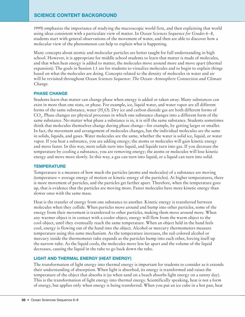
Water can absorb a lot of energy before increasing in heat because of the shape of the water molecule, and because of the hydrogen bonds holding adjacent water molecules together. Hydrogen bonds are formed between molecules when the negative end of one molecule (such as oxygen) becomes oriented to and semi-attached to the positive end of another (such as hydrogen). Water can bond to as many as four other water molecules through hydrogen bonds. It takes more energy to break the hydrogen bonds in liquid water than in most other substances, meaning water can absorb more energy before the bonds between adjacent water molecules break, and they start moving faster and bumping into one another, thereby increasing in temperature. The shape of the individual water molecules and the bonds between the oxygen and hydrogen atoms also help it absorb a lot of energy before increasing in temperature. These bonds are very flexible, which allows the water molecule to wobble in place as it absorbs energy, rather than zipping off in different directions and colliding with other molecules, which would raise the temperature of the substance.
El NIÑO In the southern Pacific Ocean, the main current flows north past Chile and Peru, along the coast of South America. When the northern flowing current reaches the equator, it bends toward the west and travels toward Indonesia and Australia. Trade winds blowing continuously toward the southwest (in the Northern Hemisphere) and northwest (in the Southern Hemisphere) along the equator help move this current westward. As the water travels along the equator, it is warmed by the Sun and by the time it reaches Indonesia, the water is very warm. Along the way the warm water also warms up the atmosphere. The warm water and air cause an increase in evaporation that result in monsoons in Indonesia and Southeast Asia. The trade winds blow even stronger as the warm air of the western Pacific starts to rise, and the winds flow in from across the Pacific to replace the rising air.
Every 3–7 years, a global climate event, El Niño, caused by interactions between the ocean and atmosphere occurs in the southern Pacific Ocean. (Its name is Spanish for “boy child” referring to the birth of Jesus, because its effects are most pronounced around Christmastime.) The effects of El Niño start in the southern Pacific, but ocean currents and atmospheric winds carry those effects around the planet. An El Niño starts when the trade winds stop blowing so hard, and the ocean surface currents crossing the Pacific lose strength, maybe even reversing direction. The warm water that had piled up near Indonesia starts to slosh back along the equator toward South America. The warm ocean water also brings with it the rains that normally fall on Indonesia, causing extreme rains and cooler temperatures in Peru, Ecuador, California, and states around the Gulf of Mexico. It also brings warm air, which pushes the jet stream of North America further north, bringing milder winter temperatures for the northern and eastern United States. Another climate change affected by El Niño is hurricanes—an increase in the Pacific and a decrease in the Atlantic.
Climate isn’t the only thing affected during El Niño. The changes in ocean circulation and weather can also cause changes that affect marine organisms. In regular years, the nutrient-rich waters off the coast of Peru are cold and and extremely productive. (See Upwelling.) When El Niño occurs, cold, nutrient-rich water is replaced with warm, nutrient-poor water that can’t support the growth of phytoplankton,

56 • Ocean Sciences Sequence 6–8
the base of the food chain. Without phytoplankton, the food web is disrupted and larger organisms can’t find the food they need to survive in the area.
UPWEllING On average, only the top 100 meters (330 feet) of the ocean has enough sunlight to support photosynthesis for microscopic organisms, such as phytoplankton. Since these organisms form the base of the ocean food web, all life in the ocean depends on the existence of this productive sunlit zone. All year long, animals and plantlike organisms die and decompose, and slowly sink toward the seafloor. As they sink out of the sunlit zone, the nutrients contained in their bodies are also removed from the sunlit zone. Upwelling is a mechanism in which the nutrients from dead, decomposed organisms contained in the deep water are brought back up to the surface in certain areas of the ocean. Upwelled nutrients act as a super-rich fertilizer for phytoplankton and other plantlike organisms in the sunlit zone. The entire food web blooms in dramatic fashion. Upwelling occurs off the west coasts of North America, South America, Africa, and Australia. It also occurs off the coasts of Spain and Portugal and around Antarctica. These areas attract most of the world’s commercial fisheries. Most of the upwelling areas are on west coasts of continents because of winds and currents working together in combination with the rotation of Earth.
ATmOSPhEREEarth’s atmosphere extends from the ground up to outer space. The dramatic bands of color in this photo taken from the International Space Station at sunset over the Indian Ocean show the layers of
the atmosphere. The oranges and yellows correspond to the first 20 kilometers (km), pinks and white are in the region of 50 km, the blues are above 50 km, and then it fades into the blackness of space. From 0–3 km above Earth’s surface, there is plenty of air to keep plants and animals alive. At this height, clouds are made of tiny water droplets. In the first 10 km of the atmosphere, it gets colder and colder as you move higher. From 3–10 km high, clouds are made of tiny ice crystals. Above 10 km, there is no longer enough air to keep plants and animals alive. There is also not enough air for weather to
happen. Planes usually fly about 10 km high so they can stay above any bad weather happening below. At about 75–85 km high, the very highest clouds form. These are not usually seen from Earth because they are so high. Meteors are rocks that enter Earth’s atmosphere from space. At 80–85 km high, there is enough air for meteors to burn. The meteors get hot from rubbing against the air. Higher than this, there is not enough air to make meteors burn. Some people consider 100 km up to be the edge of the
Satellites can detect chlorophyll (photosynthesizing pigment), which shows blooms of phytoplankton. Nutrient-poor areas are in blue.
SCIENCE CONTENT bACKGROUND

Ocean Sciences Sequence 6–8 • 57
somethingSCIENCE CONTENT bACKGROUND
atmosphere. But there is no real edge, just less and less air, with air molecules farther and farther apart as you move from near Earth into outer space.
mATTER, ATOmS AND mOlECUlESPARTICUlATE NATURE OF mATTERMatter is the term for all the “stuff” that the physical world is made of. Stars, air, water, rock, trees, flesh, and blood—are all made of matter. But not everything is matter. For example, energy is not matter. Our Sun is made of matter (mostly hydrogen gas), but it generates light and heat energy, which are not matter. Electrical current is carried through wires that are made of matter (copper), but the electrical current itself is a form of energy, not matter.
In this Sequence, students need to understand only generally what matter is, and that heat is a form of energy. Explaining matter and energy more fully is beyond the scope of this unit. You might want to tie this unit in with others you may be teaching on energy or matter. Even though matter is something that students have experience with, it is so much a part of everyday life that they are unlikely to have thought of it as a particular category. Students may initially restrict their notions of matter to things they can see or touch. Through experiences in this unit, they should begin to expand this notion of matter to include invisible gases, such as those found in air.
ATOmSAtoms are the building blocks of matter—all matter is made of atoms. Atoms are very tiny particles that cannot be created or destroyed by chemical means. To get a sense of the size of these particles, you can fit approximately one million atoms, laid end to end, in the period at the end of this sentence. If you wanted to break down the atoms even further into the subatomic particles called electrons, protons, and neutrons, which all atoms are composed of, then a great deal more energy and some sophisticated equipment would be required. There are more than 100 different kinds of atoms made up of different combinations of subatomic particles. These different kinds of atoms are called elements, and include familiar substances, such as oxygen, carbon, and hydrogen. The periodic table is a chart that organizes the elements by size and reactivity and assigns a number and symbol to each one. All the different substances on Earth are made of molecules or compounds formed by various combinations of these elements.
mOlECUlESMolecules are made of atoms joined together by chemical bonds. A molecule of a given substance is always made of the same kinds of atoms, joined in the same ratios, and arranged in the same way. For example, a molecule of water is always made of two hydrogen atoms and one oxygen atom, arranged at the particular angle often represented by a “Mickey Mouse ears” diagram. Molecules may be as small as two atoms (e.g., a hydrogen molecule, which is H2) or made of hundreds of atoms. Molecules are the stable chemical units that make up all substances and determine their properties. It is the structure of a water molecule that determines its characteristic properties of cohesion, surface tension, heat capacity, and freezing and boiling points. If this structure changes, then its properties will also change.
A “particulate view of matter,” the idea that matter is made of particles called atoms and molecules, rather than being continuous, is a difficult, but very important, concept for students to develop. In Children’s Ideas in Science, Nussbaum (1985) says, “In modern science, the fundamental notion that all matter is particulate and not continuous is of prime importance for all causal explanations of any kind of change in matter.” Students initially may view atoms or molecules as embedded in a substance like blueberries in a muffin, rather than making up the entire substance (Lee et. al. 1993). It is useful to ask students questions such as “What would be left if you took all the atoms out of this chair?” [Nothing.] Because the particulate nature of matter is so difficult for students to accept, some researchers (Gabel
58 • Ocean Sciences Sequence 6–8
1999) emphasize the importance of studying the macroscopic world first, and then explaining that world using ideas consistent with a particulate view of matter. In Ocean Sciences Sequence for Grades 6–8, students start with general observations of the movement of water, and then are able to discover how a molecular view of the phenomenon can help to explain what is happening.
Many concepts about atomic and molecular particles are better taught for full understanding in high school. However, it is appropriate for middle school students to learn that matter is made of molecules, and that when heat energy is added to matter, the molecules move around more and move apart (thermal expansion). The goals in Session 1.1 are for students to visualize molecules and to begin to explain things based on what the molecules are doing. Concepts related to the density of molecules in water and air will be revisited throughout Ocean Sciences Sequence: The Ocean–Atmosphere Connection and Climate Change.
PhASE ChANGEStudents learn that matter can change phase when energy is added or taken away. Many substances can exist in more than one state, or phase. For example, ice, liquid water, and water vapor are all different forms of the same substance, water (H2O). Dry ice and carbon dioxide gas are both different forms of CO2. Phase changes are physical processes in which one substance changes into a different form of the same substance. No matter what phase a substance is in, it is still the same substance. Students sometimes think that molecules themselves change during phase change—for example, by getting larger or smaller. In fact, the movement and arrangement of molecules changes, but the individual molecules are the same in solids, liquids, and gases. Water molecules are the same, whether the water is solid ice, liquid, or water vapor. If you heat a substance, you are adding energy; the atoms or molecules will gain kinetic energy and move faster. In this way, most solids turn into liquid, and liquids turn into gas. If you decrease the temperature by cooling a substance, you are removing energy; the atoms or molecules will lose kinetic energy and move more slowly. In this way, a gas can turn into liquid, or a liquid can turn into solid.
TEmPERATURETemperature is a measure of how much the particles (atoms and molecules) of a substance are moving (temperature = average energy of motion or kinetic energy of the particles). At higher temperatures, there is more movement of particles, and the particles get farther apart. Therefore, when the temperature goes up, that is evidence that the particles are moving more. Faster molecules have more kinetic energy than slower ones with the same mass.
Heat is the transfer of energy from one substance to another. Kinetic energy is transferred between molecules when they collide. When particles move around and bump into other particles, some of the energy from their movement is transferred to other particles, making them move around more. When any warmer object is in contact with a cooler object, energy will flow from the warm object to the cool object, until they eventually reach the same temperature. When an object held in the hand feels cool, energy is flowing out of the hand into the object. Alcohol or mercury thermometers measure temperature using this same mechanism. As the temperature increases, the red-colored alcohol or mercury inside the thermometer tube expands as the particles bump into each other, forcing itself up the narrow tube. As the liquid cools, the molecules move less far apart and the volume of the liquid decreases, causing the liquid in the tube to go back down the tube.
lIGhT AND ThERmAl ENERGy (hEAT ENERGy)The transformation of light energy into thermal energy is important for students to consider as it extends their understanding of absorption. When light is absorbed, its energy is transformed and raises the temperature of the object that absorbs it (as when sand on a beach absorbs light energy on a sunny day). This is the transformation of light energy into thermal energy. Scientifically speaking, heat is not a form of energy, but applies only when energy is being transferred. When you put an ice cube in a hot pan, heat
SCIENCE CONTENT bACKGROUND

Ocean Sciences Sequence 6–8 • 59
somethingSCIENCE CONTENT bACKGROUND
flows from the hot pan to the ice cube. This is the direction heat always travels—from the substance at a higher temperature to the substance at a lower one. Heat stops flowing between the substances once they are at the same temperature. Heat is involved in the flow of energy, but we describe the result as thermal energy. When you increase an object’s temperature, you increase its thermal energy, and vice versa.
WATER CyClEThe liquid water we use every day has existed as solid, liquid, and gas in countless situations on Earth over billions of years. Water constantly moves between the atmosphere, Earth’s surface, and underground as heating and cooling changes its phases. This movement is called the water cycle, or the hydrologic cycle. The water cycle is continuous and, therefore, has no beginning or end. The ocean and atmosphere move heat energy around Earth through air and ocean currents, and through the water cycle. Without this, Earth would be much hotter in some places and much colder in others. Most middle school students have already encountered the water cycle in previous grades, but many of them haven’t fully understood the concepts at the level focused on in this unit’s in-depth exploration. The activities and discussion in the unit provide students with opportunities to understand and verbalize evaporation, condensation, and precipitation in terms of molecular movement, density, and transfer of heat energy. These understandings will help prepare your students for higher-level concepts and a systems approach to understanding Earth processes.
EvAPORATION AND ThE WATER CyClE The Sun drives the water cycle by providing the necessary energy for evaporation. Although water evaporates at any temperature, it evaporates much more quickly when more thermal energy is present. This is why evaporation occurs more during the day, during the summer, and in the hotter areas of Earth. Evaporation also occurs more rapidly when there is wind, and wind is caused by the Sun heating different air layers. Ninety percent of the water vapor in the atmosphere is a result of evaporation of liquid water on Earth’s surface. Most of this evaporation is of ocean water, since the ocean covers more than 70 percent of the planet. Evaporation causes ocean water to cool as heat energy is used to change liquid water into water vapor. This moves heat energy from the ocean into the atmosphere in the water vapor molecules. A water molecule spends an average of about 10 days as water vapor in the atmosphere before it condenses. During that time it can travel far and move heat energy around the world, often from near the equator to other parts of Earth. There is some water vapor in all air, but the amount varies. Nearer Earth’s surface there can be quite a lot, but higher in the atmosphere there is much less. Generally, in the tropics there is more, and near the poles, less.
The other 10 percent of water vapor in the atmosphere comes mostly from transpiration. Transpiration is water evaporating from plant leaves. Plants collect water through their roots, and as they transpire or

60 • Ocean Sciences Sequence 6–8
release it, it evaporates into water vapor. You can see evidence of transpiration if you tie a clear plastic bag around the leaves on a plant and leave it there for about an hour. The water droplets inside the bag evaporated from the leaves, and then condensed on the inside of the bag
CONDENSATION AND ThE WATER CyClECondensation occurs when water vapor cools enough so that water molecules change from gas phase to liquid. Clouds are formed through condensation (or at higher altitudes where temperatures are lower through deposition, when water vapor transforms directly into solid ice crystals). When seen from below, clouds can seem very substantial, but if you fly through one, you can see how much of a cloud is just air. However, the droplets of water in a cloud are substantial enough to affect us below. Clouds emit a lot of the Sun’s energy back into space, keeping us cooler. At night, clouds can do the opposite by absorbing and emitting thermal energy toward Earth—acting like a kind of blanket. Condensation causes the air around it to warm as heat is released from the water vapor when it changes back into liquid water molecules. When the water vapor cools and condenses, the heat energy that was originally in the ocean is then released into the atmosphere.
PRECIPITATION AND ThE WATER CyClEPrecipitation occurs when drops of water or solid ice crystals that make up clouds become large and heavy enough that they fall to the ground. Most precipitation is rain, but it can also be snow, hail, sleet, or freezing rain. A large amount of heat energy from sunlight hits Earth near the equator, resulting in a huge amount of evaporation. Most of this water falls back into the ocean as precipitation. Only about 10 percent of the water that evaporates from the ocean travels in air currents and falls as precipitation on land. Most rain that falls on land, originally evaporated from the warm ocean near the equator. Over the ocean, more water evaporates than precipitates back into it. The opposite is true of land, where more water precipitates than evaporates.
The amount of precipitation that falls on land varies greatly from place to place. The temperature of nearby ocean water also affects the amount of precipitation in a given location. Places near warmer ocean water typically receive more precipitation since warmed water evaporates more, causing there to be more water vapor in the air, which increases the likelihood of precipitation. The direction of prevailing winds also plays a role as wind moves water vapor from one place to another. Other important factors that influence the amount of precipitation that falls in an area are the presence of mountains and the direction of prevailing winds. Often, the sides of mountains that are buffeted by winds have a lot more precipitation than the side where winds flow away from the mountain. The Hawaiian island of Kauai is a striking example. Kauai has the wettest spot on Earth, Mount Waialeale, which receives 450 inches of annual rainfall. However, the western coast of the island only receives about 25 inches. This can be explained by noticing that the winds tend to blow from the east toward the west. As the humid air moves up Mount Waialeale, the air cools, water vapor condenses into clouds, and it falls as precipitation. As the winds keep moving over the westward side of the mountain, the air is much less humid since much of the water vapor condensed on the other side and has already precipitated. This pattern of precipitation near mountain ranges is called the rainshadow effect. The driest place on Earth—where no rain has ever been recorded—is in a rainshadow in northern Chile where air moving in from the east loses its humidity by precipitating as it moves up and over the Andes Mountains.
RUNOFF AND ThE WATER CyClEWhen rain hits the ground and when frozen precipitation melts, liquid water may run over the surface of the ground. This is called runoff, or surface runoff. If the ground is dry and porous, like a dry sponge, the water will soak into the ground and there will be little or no runoff. If the ground is saturated, like a wet sponge, or impervious, like a plastic counter top, there may be a lot of runoff and floods may even occur. The chances of the ground being saturated are greater if there has been a lot of recent rain. An impervious surface can be rock or hard-packed dirt, but often it is an asphalt or concrete surface made
SCIENCE CONTENT bACKGROUND

Ocean Sciences Sequence 6–8 • 61
somethingSCIENCE CONTENT bACKGROUND
by humans. Runoff often begins with tiny rivulets of water trickling across the soil, which then merge to form bigger streams until they feed into creeks, rivers, lakes, or the ocean.
A watershed is an area in which the water all drains to the same place, such as a bay. Only about one-third of the precipitation that falls on land becomes runoff and reaches the ocean. The rest is evaporated, transpired, or soaks into the ground to become groundwater.
Humans affect runoff by building dams in rivers or pumping the water to other areas for use in agriculture and for drinking water. For this reason, not a single drop of the Colorado River flows into the ocean as it once did. The greatest runoff flow reaching the ocean is the Amazon River, which pumps an average of about seven million cubic feet per second into the Atlantic Ocean. Since the ocean loses more water through evaporation than is gained through precipitation, this runoff flow into the ocean is an important source of water. Runoff from the land, along with groundwater flow, keeps the ocean from evaporating away.
GROUNDWATERWe do not usually see groundwater, but it is there. If you pour water onto the sand on a beach near the water’s edge, you will see the water soak in. If you dig into the sand, it will be damp from water that has soaked down between the sand grains. If you dig down deep enough, you will reach the water table where water fills all the spaces between the sand grains. It is easier to see these things on a sandy beach, but they exist below our feet wherever we are. Of all the freshwater on Earth, the largest percentage is frozen in snow and ice at the poles and on mountains. The second largest portion is in groundwater. The water in all the streams and lakes in the world comes in a distant third
UNIT 2: how Does Carbon Flow through the Ocean, land, and Atmosphere?
ATOmS, ElEmENTS, mOlECUlES, AND CARbONAtoms are the building blocks of all matter, and there are a few more than 100 types of atoms, called elements. Carbon is one element. The elements are organized according to their structures and properties on the Periodic Table of Elements. Different types of atoms can combine to form molecules. A molecule can be as small as two atoms or composed of thousands of atoms. Students may confuse molecules and atoms. If your students are unfamiliar with molecules and chemical formulas, you might want to use the analogy that atoms are like the letters of the alphabet, and molecules are like the words formed from those letters.
Carbon is one of the more abundant elements in the universe and on Earth. It is a part of many different types of molecules, including carbon dioxide (CO2), starch, sugars, calcium carbonate (CaCO3) which makes up limestone and animal shells, carbonic acid (H2CO3) which forms when carbon dioxide dissolves in water, and the hydrocarbons of fossil fuels. Carbon on Earth is a part of all living things and things that were once alive.
ThE CARbON CyClEThe carbon cycle on Earth is the system of reservoirs containing carbon and the flows that move carbon between these reservoirs. The carbon cycle includes living things (both on land and in the ocean) taking in carbon from the atmosphere through photosynthesis and then later returning carbon to the environment through respiration, decomposition and decay, fossil fuel formation, and combustion. Understanding the carbon cycle is key to understanding the causes, effects, and solutions to climate