unique - nra · unique transport for heavy ... were considered during preliminary design included a...
TRANSCRIPT

4 108
uniquetransport for heavy loadBy Tom KellySANRAL SOUTHERN REGION
NOV 2007
These two bridges entailed the onsitemanufacture and placement of 96 huge,extremely heavy, precast concrete beams.Each beam, with an I cross section, is33 metres long and 2,1 metres high and
In January 2006, the Contractto upgrade a portion of NationalRoute 10 between the TarkaBridge and Cradockcommenced with the sitebeing handed over to thecontractor Group Five/IlimaJoint Venture. The projectinvolves the rehabilitation andrealignment of 3,2 kilometresof the existing road, a flood-plain fill and the constructionof two river bridges over theGreat Fish River.
varies from 0,600 to 0,220 metres wideand weighs 58 tons. The beams werecast in an on site precast beam yardwhich was close to one site, but remotefrom the other bridge site.
plettenberg bay:pedestrian bridge
construction of thetsitsa river bridge
road survey vehicle
transport for heavy load

Discla imer
The views expressed in this newsletter are not necessarily
the views of SANRAL or the publishers of this newsletter, nor
their directors and management, and they will not be liable
for any losses or damages which any party may suffer as a
result of any view or fact which is expressed in this newsletter.
content l ine up
The problem was therefore tofigure out the manner in whichto transport and lift these beamswhich will form the base of thedecks of both bridges.
The giant beams weighing upto 58 tons were precast in ayard close to one bridge andtransported on a giant trailer tothe individual bridge pier forfinal placement. TheContractor’s design & planningteam worked with theconstruction site team toanalyse and optimise alltemporary equipment neededto manufacture, transport andlift the beams into place, usinga 250 ton mobile crane.
A huge 50m long trailer togetherwith a horse and steel framewas used to transport thebeams. It was speciallymanufactured by the Contractorin their workshop at Spartan.The Contractor assembled thiscustom made trailer on site. Thehorse and trailer was designedto carry the 15 ton frame andthe 58 ton beam.
Continued from Page 1
Unique transport forheavy loadThe upgrade of a portion ofNational Route 10
Construction of thebridge over theTsitsa RiverBringing economic stimulusto the Eastern Cape region
Plettenberg BayPedestrian Bridge:Winner of the Steel AwardThe Bridges Category
Road Survey VehicleBackground to the use of theRoad Survey Vehicle (RSV)
SANRAL’Sapproach tooverloading control
1
4
8
10
The Plettenberg Bay Pedestrian Bridge. Pg 8 The 48m frame was fabricatedin two sections each 21,5mlong, using 6mm thick steeltubing 168mm in diameter. At3,2 metres wide and 3,2 metreshigh the triangular structure andtrailer stood six metres aboveground for transport to the site10 kms south of Cradock.
13
2

3
The contractor assembled this custommade trailer, designed to take the steelframe from which the precast beams
are suspended.
The photographs show the beam transporttrailer with a beam being transported and thespecial mobile lifting crane to lift and place thebeams.

4
development
Background
The Laleni community are resident in a small area on the west bank of the Tsitsa River in the EasternCape Province. The nearest town and administrative area is Qumbu which is approximately 15kms northof this village. Access to Qumbu has historically been difficult with community members either travellingsouth to the N2 on district road D8170 and then on to Qumbu a distance of over 45 km, or crossing theriver on boat or by foot and travelling on the D8167 and N2 to Qumbu, a distance of less than 20km.Residents also cross the river to make use of the secondary school and clinic, for social engagementsand to access natural resources such as firewood. During low flow periods it is possible to wade acrossthe river. A dilapidated boat was also used occasionally as a ferry. Whilst crossing the river during lowflows could be considered merely inconvenient it was extremely hazardous attempting the crossing inmedium and high flow conditions with an average of five lives lost every year, children and the elderlybeing most effected.
CONSTRUCTIONCONSTRUCTIONof the bridge over the Tsitsa River
By Ravi RonnySANRAL EASTERN REGION
The Tsitsa River Bridge project for the Laleni community in the Eastern Cape provided stimulus to theregion which is characterised by high levels of unemployment and little infrastructure. The Lalenicommunity now have a safe, convenient all weather access to the facilities and resources which werepreviously inaccessible. The project merits recognition as a community based project due to its uniqueinitiation by the local community and by the form of design and contract adopted by SANRAL whichensured a maximum benefit to the community by the engagement of labour, plant and material fromthe region, during the construction stage.

5
Design approachStaff from SANRAL’s Eastern Region office met withthe community in December 2004 to discuss theirrequirements and to assess the feasibility of buildinga structure across the river at the most desirableand cost effective crossing. SANRAL commissioneda specialist environmental consultant to carry outthe detailed environmental study and scoping report. The hydraulic analysis was undertaken by aspecialist hydraulic consultancy. The structuraldesign work was carried out in-house by SANRALpersonnel Ravi Ronny and Edwin Kruger therebyreducing external design costs and maximising thebudget available for actual construction.
The scoping report furthermore indicated thatdespite the dangers inherent in crossing the river,community members preferred this route to Qumbuas it was much quicker and more significantly itwas considerably cheaper.
The Tsitsa River is one the larger rivers and together with theTina River leads into the Mzimvubu River, the largest in theEastern Cape. The challenge for SANRAL was therefore todesign a cost effective solution that would balance the cost ofconstruction, have a high level of service and low maintenancecosts, and provide access to much needed social services tothe community. It was therefore apparent from the outset thathydraulic considerations would have a large bearing on thestructural solution adopted.
The Tsitsa River at the point of crossing has a catchment areaof over 4300 km2 and a watercourse length of 180km. Theregion is characterized by heavy summer rainfall with an averageannual rainfall of 860mm. There is a significant seasonaldifference in flow rates with a mean winter flow rate of 8m3/sand a mean summer flow rate of 42 m3/s.
Flood peaks were calculated through various methods.Consideration was given not only to the size of the design floodbut also the duration of the flood peak to determine the lengthof time that a low-level structure would be overtopped.
Fortunately founding conditions for the proposed structurewere good with a slightly to moderately weathered mediumhard rock sandstone shelf extending across the riverbed.Structural forms that were considered during preliminary designincluded a suspension bridge, a steel truss bridge and a multiplespan reinforced concrete bridge. A cost benefit analysis wasalso undertaken comparing a pedestrian bridge with a singlelane vehicle bridge with a pedestrian walkway. The concretesingle lane bridge was considered the most appropriate bridgeas it was the only form that easily accommodated vehicles andpedestrians, had low maintenance costs and would provide themost benefit to the community during the construction stageand after construction. Two options for the concrete bridgewere considered. A high level structure above the 1:50 yearflood and a lower level structure slightly above the 1:5 yearflood level. The high level structure had a total length of 133mand a height of approx 7,5m. In comparison the lower levelstructure had a length of only 102,6m and a height ofapproximately 5m. Theoretical inundation periods werecalculated for the various return periods. Time inundated variesfrom 28 hours for a 1:10 year return period to 63 hours for a1:100 year period. Considering the ten year event this meantthat the low level structure would be accessible 99,97% of thetime. From the foregoing it was deemed appropriate to proceedwith the low level structure option due to considerable cutsavings.
The factors influencing a high level structure is that it is difficultto construct, and additional safety measures would have beenrequired to mitigate and safety concerns of the workers. Thehigh level structure is also more labour intensive and requirea high quality concrete due to longer spans with prestressedbeams. To cast the substructures, and use of a mobile cranewould be required to fix shutters into position as well as transferconcrete from the mixing drums to the substructure positions.For a low level bridge however, all work could be done manuallyusing access scaffolds and wheelbarrows.
The bridge structure was designed in a form that maximizedthe utilization of the local labour force. The bridge has nine

6
for Gauteng
Continued from Page 5
11,4m equal spans. The deck issupported on wall type piersand abutments. The piers haveinclined upstream faces to limitdebris accumulation. Thesubstructures were anchoredinto the base rock by drilling andanchoring large diameter bars toan approximate depth of 1,5m.The deck consists of precastinverted “T” beams with in-situconcrete infill. Considering theproportionately high volume ofpedestrian traffic to vehiculartraffic the deck has a singlevehicle lane and a dedicatedpedestrian walkway. A concreteroad approximately 100m longwas provided on the bridgeapproaches due to the steepapproach grades and to preventpotential erosion when largefloods passed through. Thebalance of the approach roadswere constructed from gravelmaterial sourced from existingborrow pits in the area.
A proprietary rubberisedbitumen product and gradedstone called GravSeal was thenused to surface the road
Construction
Following a tender process Goba(Pty) Ltd were appointed as theconsulting engineers to carry outa check on SANRAL’s design andtender document, request fortenders and to monitorconstruction. The tenderdocument for the constructionof the bridge had specificprovisions to ensure that therewere lasting benefits to thecommunity. These includedrequirements that the successfultenderer engage localcontractors and labour andsource all material and plant fromthe district. A project liaisoncommittee (PLC) was formedfrom interested and affected
members of the community and included representativesfrom local government, tribal authorities, politicalorganizations, religious organizations and social groups.A labour desk officer and public liaison officer (PLO) wereappointed to manage the day to day tasks associatedwith the above and to provide feedback at and betweenthe monthly meetings.
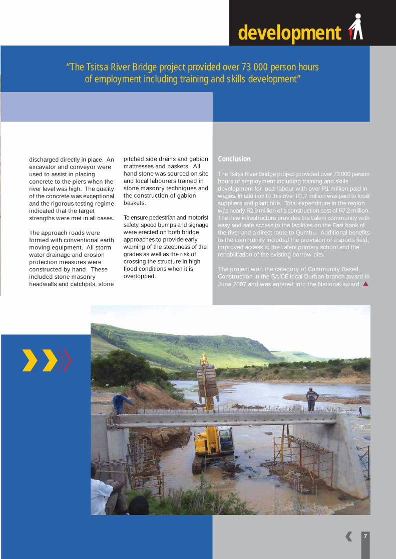
Due to cash flow problems experienced by the successfulcontractor, the work was reassigned and therefore workonly commenced in September 2005 by ZEKConstruction, a fully black owned company. Diversionstructures consisting of geofabric lined gabion basketsand earth embankments were formed to facilitate theconstruction of the piers and abutments. The diversionstructures were washed away on a number of occasionswhen the river flooded during an extremely wet season.Despite these setbacks the contractor finished the sub-structures on programme. Precast beams for the deckwere constructed on a level area adjacent to the eastriver bank. The beams were placed sequentially fromthe East abutment so that all in-situ deck concrete couldbe transported by wheelbarrow. A batch plant was setup at the East Abutment to provide all concrete for useon site. A large labour contingent was used with up to4 small drum mixers to produce the concrete. Theconcrete was transported by wheel barrow and
development
discharged directly in place. Anexcavator and conveyor wereused to assist in placingconcrete to the piers when theriver level was high. The qualityof the concrete was exceptionaland the rigorous testing regimeindicated that the targetstrengths were met in all cases.
The approach roads wereformed with conventional earthmoving equipment. All stormwater drainage and erosionprotection measures wereconstructed by hand. Theseincluded stone masonryheadwalls and catchpits, stone
7
pitched side drains and gabionmattresses and baskets. Allhand stone was sourced on siteand local labourers trained instone masonry techniques andthe construction of gabionbaskets.
To ensure pedestrian and motoristsafety, speed bumps and signagewere erected on both bridgeapproaches to provide earlywarning of the steepness of thegrades as well as the risk ofcrossing the structure in highflood conditions when it isovertopped.
Conclusion
The Tsitsa River Bridge project provided over 73 000 personhours of employment including training and skillsdevelopment for local labour with over R1 million paid inwages. In addition to this over R1,7 million was paid to localsuppliers and plant hire. Total expenditure in the regionwas nearly R2,9 million of a construction cost of R7,2 million.The new infrastructure provides the Laleni community witheasy and safe access to the facilities on the East bank ofthe river and a direct route to Qumbu. Additional benefitsto the community included the provision of a sports field,improved access to the Laleni primary school and therehabilitation of the existing borrow pits.
The project won the category of Community BasedConstruction in the SAICE local Durban branch award inJune 2007 and was entered into the National award.
“The Tsitsa River Bridge project provided over 73 000 person hoursof employment including training and skills development”

8
Plettenberg Bay
It became clear that a formalizedgrade separated crossing of theN2, such a pedestrian bridgewas required to provide safepassage for pedestrians,particularly in the morning andevening travel peaks. Althougha strategically located pedestrianbridge would relieve part of theroad safety concerns, thecongregation of work seekersand unsafe stopping on the N2still presented a problem. Therewas a need to attractpedestrians and motorists to asafer location that would alsoencourage the use of thepedestrian bridge.
Pedestrian Bridge:Community Development Project
By Randall CableSANRAL WESTEN REGION
An unsafe situation existed on the N2
near the Piesangvalley intersection in
Plettenberg Bay where hundreds of
pedestrians crossed the busy N2 to
places of work, as well as congregate
adjacent to the N2 to wait for work
opportunities. Unsafe operating
conditions are further compounded by
motorists illegally stopping on the N2 to
pick up and/or drop-off workers.
The concept of a Drop-off andCollection Zone (DCZ) integratedwith the pedestrian bridge wasthe logical solution. It wasconsidered that providing directaccess to a formalized DCZ fromthe pedestrian bridge would re-direct pedestrians from thecurrent practice of crossing theNational Route randomly. Afurther intention of the proposedDCZ is to provide a moreformalized arrangement foremployment seekers. As aresult it is intended that the DCZinclude:
• Safe drop-off and collectionfacilities;
Winner of the SAICE Steel Award – Bridge Category 2007

9
Toll Tunnel
• A labour desk office;• Shelter and seating; and• Ablutions facilities.
The integration of the design ofthe DCZ together with theproposed pedestrian bridge isaimed at improving bothvehicular and pedestrian safetyalong the N2 in the vicinity ofthe Piesang Valley Intersection,as well as addressing socialneeds of employment seekers.
DesignThe design objective for thepedestrian bridge, in the BitouMunicipality in the WesternCape, was to produce aneconomical and functionalaesthetic structure that may
serve as a landmark for the localcommunity. The bridge decidedupon was a skewed arch steelbridge guaranteed to make roadusers look twice. The bridge isconstructed from steel plate andtubing. The structural systemis a first in South Africa.
Technical DetailsThe bridge is a three spanstructure, with a main span of28.1m and back spans of 9.0m.A single asymmetric tubularsteel arch supports a 2.2m widebox deck constructed from steelplate and tubing. The arch isinclined at 10 degrees to thevertical with inclined taperingchannel sections tying the archto the box deck. Sloping pier
struts constructed from steel tubing are used asspringing points for the arch. The structure issupported on reinforced concrete bases that arekeyed into the competent rock on either side ofthe N2.
The horizontal alignment of the bridge is set out ona 100m-radius curve across the National Route 2with the deck’s vertical alignment following a 260mradius curve. Reinforced concrete abutments provideaccess to the structure on the northern and southernembankments.
ConstructionThe construction of the reinforced concrete basesand abutments in Plettenberg Bay took placeconcurrently with the fabrication of the steel structurein Cape Town. After the final welding of the structurewas completed in the fabrication yard, the arch andthe deck were dismantled into four separate sections.These components were then painted in a controlledpaint shop with a zinc rich primer and two layers ofepoxy micaceous iron oxide paint with an acrylicpolyurethane top coat.
These structures were then transported some 500kmto Plettenberg Bay, where it was reconstructed inthe central island. The full length of the bridge waslifted into place with two 220t cranes and weldedonto the circular steel supports.
The pedestrian bridge has been completed and isin operation. The Bitou Municipality is currentlybusy with the construction of the DCZ.
EXTERNAL SERVICES PROCUREDFOR THE PROJECT:
Design and Construction SupervisionEngineering Services: Vela VKE (Pty) Ltd
Contractor: Civils 2000 (Pty) Ltd(Responsible for Civil Works)
Subcontractor: D&D Fabrication (Pty) Ltd(Responsible Steel Fabricator and Erector)

10
ROAD
By Louw KannemeyerSANRAL HEAD OFFICE
Background to the use of the Road Survey Vehicle (RSV) at theSouth African National Roads Agency Ltd.
Project selection within
SANRAL occurs through our
pavement management system
(PMS). PMS refers to a
systematic method of
information collection and
decision making support to
permit the optimisation of
resources for the maintenance,
rehabilitation and the
construction of new
pavements, generating a
programme of works and
corresponding budget which
match a defined level of service.
The pavement management
decision support system is a
computerised sub-system of
the overall Road Network
Management System that:
• access a centralised roadnetwork database for inventory,condition and utilisation data;
• then utilising the data for lifecycle predictions of roaddeterioration, maintenanceneeds, agency costs and usercosts, and combining the aboveaccording to the selectedobjective function to producean optimised budget.
SURVEY VEHICLE
SANRAL RoadSurvey Vehicle
Data CollectionThe Pavement ManagementSystem of SANRAL is a wellestablished, documentedprocedure for the execution ofthe pavement managementactivities in a schematic and co-ordinated manner with theobjective of identifying theoptimum strategies for providingand maintaining pavements at anadequate level of service for thefunding available. To achieve theabove mentioned an intimateknowledge of the condition of thenetwork is required. This intimateknowledge is obtained throughvarious condition surveys of thenetwork. One of the mainobjectives during these surveysis to capture the information in asshort a time span as possible,thus eliminating any adverseenvironmental and traffic loadinginfluences. This has resulted inthe development of automatedmobile data acquisition vehicles
capable of collecting data athighway speeds. The SANRALRoad Survey Vehicle as seenabove is one such an exampleof a survey vehicle that waslocally assembled by SANRALusing the latest availableinternational technology. Thedigital electronic componentsused included numerous lasers,accelerometers, gyro’s,Differential Global PositionSystem, digital video systems,distance measuring instrumentsand power supply systems.These advanced digitalelectronic systems enable theRoad Survey Vehicle to recordvarious road characteristicswhilst moving along with thetraffic stream at speeds between20 to 120 km/h. A traffic andweather condition permittingthe vehicle is able to collectcondition data for 500 lanekilometre per day.

11
The texture wavelength components captured by the Road SurveyVehicle and utilised during road pavement asset management in ourorganisation are illustrated below. These international definitions ofroad surface irregularities were defined on a scale of relative texturewavelengths by the Belgium Road Research Centre (PIARC, 1987).
SANRAL RoadSurvey Vehicle –side view
Texture Wavelengthinfluence on SurfaceCharacteristics
SANRAL Road SurveyVehicle – Interior View
Tyre Wear Tyre Damage
Rolling Resistance
Splash & Spray
In-vehicle noise
Exterior noise
Wet Pavement Friction
Microtexture Macrotexture* Megatexture* Roughness* Vertical Curves*
0,5mm 50mm 0,5mm 50mm
Texture Wavelength
* Measured by RSV

12
• In addition to the above texture wavelength components captured by the RoadSurvey Vehicle, it also records Transverse/Cross Profile; surface video and rightof way video information.
• Macrotexture: Macrotexture isassociated with the coarseness ofthe road surface (as illustratedbelow) that affects water drainagefrom the tyre print, tyre tread rubberdeformations, the friction-speedgradient and skid resistance at highspeed. Although microtexturedetermines the maximum skidresistance afforded by a dry
pavement, it is the macrotexture thatdetermines how effective themicrotexture will be when thepavement is wet. Most skiddingrelated accidents occur on wetpavements. The main user costsinfluenced by macrotexture arerolling resistance (affecting fuel, oiland tyre costs), accidents (for speedsin excess of 70 km/h, and as affectedby spray-impared visibility).
• Vertical Curves: Vertical curvesare associated with wavelengthcharacteristics longer than 50mand has impact on vehicleoperating speed, vehicleoperating costs and road safetythrough sight distance.
• Roughness (LongitudinalProfile): Roughness is a defect,comprising those surfacedeviations which influence, andare relevant to, the motion andoperation of a moving vehicle; thatis, through the user’s perceptionof riding quality, the wear andoperating costs of vehicles, roadsafety, and the impact of the vehicleon the road through excitation ofthe vehicle mass. As indicated inthe diagram, roughness is definedto extend over a range from 0,5mto 50 m. It has been shown by theAmerican Association of StateHighway Officials road test(AASHO) that roughness of thesurface profile of a road accountsfor 95 per cent of the road user’sperception of serviceability. It isthus not surprising to note that inSouth Africa roughnessmeasurements initiated in the early1970’s and since then it hasbecome one of the most importantinstrumental surveys conductedon our roads since it combines theeffect of all distress types on theroad user as illustrated. As a resultof this, roughness is in mostinstances the only distressparameter value passed to thevehicle operating cost sub-modelsof a pavement managementsystem, which utilise it along withother parameters to estimated thetiming, type and cost ofmaintenance needs.
• Megatexture: Megatexture is adefect, comprising those verticalsurface deviations of thepavement surface in the rangeof 50mm to 0.5m which mayhave an adverse influence onvehicle handling characteristics(affecting vehicle tracking), safety(potholes), dynamic loading andin vehicle noise.
Illustration of longitudinal and transverse profiles
Illustration of macro and micro texture

SANRAL has an indirect responsibility towards its roadconcessionaires for law enforcement. If overloading damagesthe roads of the concessionaires, SANRAL must compensatethem for the damage caused. Loss of infrastructure throughoverloading on all other roads is carried by SANRAL itself.Quite obviously, it is important to SANRAL that the damagecaused by overloaded vehicles is limited as far as possible,and that claims by concessionaires for road damage areavoided.
It would be easy enough for SANRAL to protect its roads bymeans of weighbridges and leave the provinces and cities
13
SANRAL’Sapproach to overloading control
Contrary to the beliefs of some, The South African NationalRoads Agency Ltd (SANRAL) is not a law enforcementagency. However, it has a direct interest in its level andefficiency. Of particular concern to SANRAL are theproblems of overloading and our poor road safety figures. The organisation involves itself in these activities throughagreements with other authorities that are tasked to carryout law enforcement.
By Geoff AckermanSANRAL HEAD OFFICE

Continued from Page 13
to bear the brunt of theoverloading that will inevitablydeviate to their roads. Thiswould not be responsible of theorganisation and neither wouldit benefit the country in any way.The problems of road damage,unfair competition in thetrucking industry and the roadsafety risks raised byoverloading would notdisappear. Clearly, overloadingcontrol solutions need to beimplemented in cooperationwith provincial and localauthority partners involved inroads and law enforcement.Any solution provided isrequired to be as cost efficientas possible, send the rightmessage to the trucking industryand promote responsible useof our roads.
SANRAL’s strategy foroverloading control isbased on several importantprinciples.First of all, SANRAL’s approachis to form partnerships withother authorities and the private
sector to create and operateoverloading controlinfrastructure. Theimplementation of overloadingcontrol systems requires lifecycle costing to drive systemdesign, the entering into formalagreements between SANRALand other parties involved andthe clear allocation of duties andresponsibilities.
Secondly, the NationalOverloading Control Strategy ofthe Department of Transport notonly deals with law enforcementbut also encourages the privatesector to implement selfregulation in respect of loading.SANRAL strongly supports theRoad Transport ManagementSystem (RTMS) initiative, whichadvocates best practise inrespect of the loading ofvehicles, their roadworthiness,driver wellness and the conductof consignees and consignors.RTMS is currently beingdeveloped into an accreditationscheme consisting of variousparts, the first of which has been
Minister of Transport, Jeff Radebe inspecting a vehicle atthe Donkerhoek overload station.

finalised (Code of recommendedpractice, ARP 067-01). The twoother ARP documents arenearing completion. After aperiod of trial implementation,the ARP documents will bedeveloped into fully fledgedSANS standards. Responsiblecompanies, whether they maybe consignors of goods, hauliersof consignees, will be able toseek accreditation in the industryand will be able to lay claim toa higher level of managementresponsibility and compliancewith the laws of the country.
Thirdly, SANRAL’s futureapproach will be to build as fewmajor overloading controlcentres as possible, but willaugment these with numerouslay-byes where trucks can beweighed. If any truck issuspected to be overloaded ata lay-by, it will be electronicallytagged and sent to the nearestproperly equipped weighingcentre to be legally weighed,while being monitored on itsway by a tracking system. Thiskind of system offers the mostflexibility for scaling operationsup or down according todemand. Electronic systems aredeveloped by the private sectorand are abreast of the latesttracking and weighingtechnology.
Finally, the agreements thatSANRAL enters into with itsvarious partners and contractedparties are crafted to securepermanent system and facilitymaintenance, services by thetraffic law enforcement agenciesand system managementaccording to service levelstandards.
15
The National Overloading ControlStrategy of the Department ofTransport not only deals with lawenforcement but also encouragesthe private sector to implementself regulation

CREATING WEALTHTHROUGH INFRASTRUCTURE
Our roads are designed to co-exist with the environment.As important as a world-class national road network is to the prosperity of our country, TheSouth African National Roads Agency Limited also understands the impact our roads haveon the natural habitat of our country. When it comes to bio-diversity, our roads are designedwith careful consideration and built to co-exist with the environment.For more information visit www.nra.co.za
The South African National Roads Agency LimitedDitsela Place, 1204 Park Street, Hatfield, 0083PO Box 415, Pretoria, 0001 South AfricaTel (012) 426 6000 Fax (012) 362 2116/7
If you have any comments, information or articles,please send to [email protected]