understanding water quality in residential...
TRANSCRIPT

Understanding Water Quality in
Residential Communities:A Workshop for Real Estate Professionals
Thursday, January 28th 20169:00 am - 11:00 am
Murrells Inlet Community Center, Murrells Inlet, SC
Michelle LaRocco, Coastal Training Program Coordinator
Lisa Swanger, Coastal Waccamaw Watershed Education Programs
Coordinator

Today’s Outline
Welcome & Introductions
Watersheds & Coastal Water Quality
National Pollution Discharge Elimination System
Common Components of a Stormwater System
Break
Introduction to Low Impact Development
Tools & Sources for Realtors
Questions & Answers

Established 1992

North Inlet- Winyah Bay
National Estuarine Research Reserve
Science-based:• Tools• Information• Skill-building
Map courtesy of SCDHEC

Coastal Waccamaw Stormwater Education Consortium
To develop and implement effective,
outcomes-based stormwater education and
outreach programs to meet federal
requirements and satisfy local
environmental and economic needs.

Today’s Outline
Welcome & Introductions
Watersheds & Coastal Water Quality
National Pollution Discharge Elimination System
Common Components of a Stormwater System
Break
Introduction to Low Impact Development
Tools & Sources for Realtors
Questions & Answers

An area of land that drains to a single
outlet
Watersheds & Coastal Water Quality:
What is a Watershed?

Watersheds & Coastal Water Quality:
Watershed Scales
Neighborhood
Watersheds
River Basin
Watersheds

Among multiple activities in places
Between people and places
Watersheds & Coastal Water Quality:
Watersheds Are About Connections

Watersheds & Coastal Water Quality:
Our Watershed - A Real Estate Market Premium
• Myrtle Beach 2nd
fastest growing in
the US.
• What attracts
people to move to
this area?
• Local natural
resources – help
market properties.

Watersheds & Coastal Water Quality:
Components of Impervious Cover

Watersheds & Coastal Water Quality:
Impacts of Development - Impervious Cover

Watersheds & Coastal Water Quality:
Common Pollutants & Problems
• Bacteria: animal waste, septic systems, sediment runoff
• Chemicals: pesticides, chlorine, detergents
• Nutrients: fertilizers, sediment, under-vegetated lawns
• Litter: cigarette butts, trash
• Heavy Metals & Oil: breaks, engines, oil leaks, tire wear
• Natural Debris: yard debris, grass clippings, leaves
“Pollution reduces a community's ability to use waterways for
swimming, fishing, and drinking, and it adversely impacts wildlife
populations. These problems create negative impacts on a
community by reducing livability, suppressing the local economy,
and increasing the cost of using water as a natural resource”
(REALTOR® Magazine).

Watersheds & Coastal Water Quality:
Common Pollutants & Problems

Today’s Outline
Welcome & Introductions
Watersheds & Coastal Water Quality
National Pollution Discharge Elimination System
Common Components of a Stormwater System
Break
Introduction to Low Impact Development
Tools & Sources for Realtors
Questions & Answers

National Pollution Discharge
Elimination System Phase II
Permit Program
Point Sources vs. Nonpoint Sources
Federal Mandate: NPDES
• Phase I Stormwater Program
-Populations over 100,000 &
industry
• Phase II Stormwater Program
-Located in Urbanized Areas
-Small MS4 communities
(small Municipal Separate
Storm Sewer Systems)
-South Carolina has over 70
regulated SMS4s

Today’s Outline
Welcome & Introductions
Watersheds & Coastal Water Quality
National Pollution Discharge Elimination System
Common Components of a Stormwater System
Break
Introduction to Low Impact Development
Tools & Sources for Realtors
Questions & Answers

Components of a Stormwater System:
Neighborhood Drainage Features

Basic Definitions:
Swale: Rain falls on the impervious area of a residents property
and runs to the swale at the outer edges of the property.
Catch basins: A structure which captures surface water and acts
as a junction point where pipe segments connect.
Curb inlets: Basically do the same thing a catch basin, except it
captures water from the road rather than a back yard.
Pipes: Once the water falls into the catch basin or curb inlet, it
flows through a gravity fed pipes system falling out into the pond.
Weir: This slow draining is done using a weir structure.
Components of a Stormwater System:
Neighborhood Drainage Features

Components of a Stormwater System:
Example Neighborhood As-Built

Components of a Stormwater System:
Neighborhood Drainage Features - Ponds
Neighborhood Stormwater Pond Function to:
1) Hold and move water
2) Hold sediment and solids

Components of a Stormwater System:
Neighborhood Drainage Features
HOAs are the “operators” of their residential stormwater system. An ongoing challenge is to balance
utility verses amenity.

Today’s Outline
Welcome & Introductions
Watersheds & Coastal Water Quality
National Pollution Discharge Elimination System
Common Components of a Stormwater System
Break
Introduction to Low Impact Development
Tools & Sources for Realtors
Questions & Answers

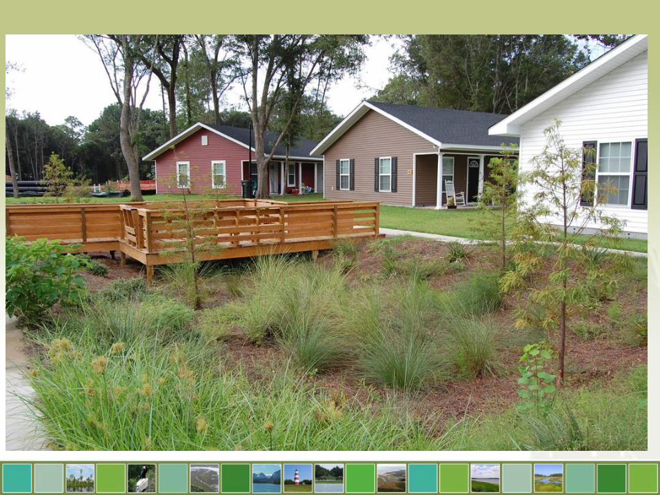
What Is Low Impact Development

What is LID?


45% impervious

25% Impervious


Benefits of Low Impact Development

Municipalities

Developers
Over 60% of builders and remodelers report their customers are willing to pay more for green.
– McGraw Hill Construction Market Report

Source: National Green Building Homeowner Survey by Quality Guild

“Best New Community of 2013” by the Charleston Homebuilders Association

Oak Terrace Preserve
Why LID?

Why LID?


Today’s Outline
Welcome & Introductions
Watersheds & Coastal Water Quality
National Pollution Discharge Elimination System
Common Components of a Stormwater System
Break
Introduction to Low Impact Development
Tools & Sources for Realtors
Questions & Answers

Online Tools and Data

FEMA flood maps
• Current Flood Maps: https://msc.fema.gov/portal
• Flood Map Updates –http://www.fema.gov/view-your-communitys-preliminary-flood-hazard-data-0

Digital Coast Maps
• NOAA Digital Coast http://coast.noaa.gov/digitalcoast/
• Coastal Flood Exposure Mapper: http://coast.noaa.gov/digitalcoast/tools/flood-exposure

South Carolina Maps• DHEC online map portal:
http://www.scdhec.gov/HomeAndEnvironment/maps/GIS/Applications/
• Beachfront Jurisdictions: http://gis.dhec.sc.gov/shoreline/
• Beachfront property guide: http://www.scdhec.gov/library/CR-003559.pdf

Thank You!
Michelle LaRoccoCoastal Training Program Coordinator
www.northinlet.sc.edu
Lisa SwangerCoastal Waccamaw Watershed Education
Programs Coordinator
[email protected](843) 349-2839
www.cwsec-sc.org