understanding seismic amplitudes a case history from kg ... · as amplitude study needs good...
TRANSCRIPT

E & D Directorate, ONGC, Kaulagarh Road, Dehradun, 248001, India. [email protected]
Understanding Seismic Amplitudes – A case history from KG Basin, IndiaC.Visweswara Rao, Dr. R.Prasad, K.V.Vadiraj*, ONGC, [email protected]
Summary
Seismic amplitudes play an important role in detection ofhydrocarbon bearing prospects which in turn depend onvarious factors right from seismic data acquisition andprocessing. Authors have gone through the amplitudeissues related to the area under discussion case by case andthen put up the summary of the study. Amplitude inKrishna-Godavari Basin responded positively in manyoccasions during hydrocarbon exploration and this studyand observations will definitely help in pinpointing thelocales to a greater extent.
Introduction
Many E & P companies have discovered the value ofamplitude studies for hydrocarbon exploration andexploitation and have planned special studies on amplitudesbefore going ahead in a big way in to the game. KG Basinbeing a promising and producing Basin for furtherexploration and production, understanding amplitudes andtheir behavior is the need of the hour. Authors attemptedstudy to understand and analyze the reasons and suggestedpossible way forward.
KG Basin in Brief:
Krishna Godavari Basin is a poly-history, peri-cratonicbasin lies between Kakinada in the northeast and Ongole inthe southwest with Archean crystalline basement andUpper Cretaceous sedimentary outcrops demarcating thenorthwest basin margin. To southeast the basin extends intothe deep water of the Bay of Bengal. The area is drained bytwo major rivers Krishna and Godavari. With playsdistributed over a large stratigraphic section from oldestPermo-Triassic Mandapeta Sandstone in onland to theyoungest Pleistocene channel levee complexes in deepwater offshore it has great potential to host large volumesof hydrocarbon reserves.
The basin can be broadly subdivided into Onland, Shallowwater & Deep water sectors.
The Onland sector of the basin has three sub basinalentities based on the tectonic settings- Krishna, WestGodavari and East Godavari separated by two basementhorsts the Bapatla and Tanuku horsts. Krishna sub basincontains mainly Cretaceous and older sediments above theArchean basement which is separated from the adjoiningWest Godavari sub basin by Bapatla horst. The West
Godavari sub basin contains two grabens Gudivada andBantumilli with in-between Kaza-Kaikalur horst. In WestGodavari Sub basin the Early Cretaceous and older (UpperJurassic) Sequences are the known hydrocarbon habitats.The East Godavari Sub basin is bounded by Poduru-Yanam/ Draksharama - Endamuru High in the east. TheKommugudem and Mandapeta troughs are situated oneither side of the Tanuku horst. In East Godavari sub –basin the occurrence of hydrocarbon habitat ranges fromPermo-Triassic to Pliocene.
The shallow offshore sector is related to the deltaprogradation during late Cretaceous and Paleogene –Neogene of Krishna-Godavari fluvial system. The fast syn-sedimentation subsidence within shelf edge of the passivemargin has yielded extension-subsidence related syn-sedimentary growth fault tectonics with huge pile ofsedimentation on the hanging wall and thickening furthertowards south-east basinal gradient. The younger sedimentsoverstep the older in making a prograding advancesequence. The basin experienced shale flowage under theinfluence of squeeze tectonics along growth fault system.The effect of rapid sedimentation oversteps theaccommodation space resulting gliding along listricextensional faults and propagating hanging wall collapse.Tertiary witnessed series of transgressive-regressive cycleswith growth fault related depositional settings. The presentday shallow offshore corridor exhibits the deformed stylecomprising number of listric normal faults with a few antiregional faults, depositional thrust (toe thrust resulted dueto phenomenon of shale mobility) towards distal slope.
In Deep water sector, migration of delta overlying themobile shale layer exhibits compression structures in theform of delta toe fold and imbricate thrust towards basinslope. The imbrication thrust is primarily attributed to theeffect of excess sediment loading above the plastic mudlayer further culminating in the form of toe thrust. Thepresent deep water regime is characterized by shelf, slopeand basin floor corridors. Various depositional elementslike mud rich debris flow with chaotic slump fills, turbidityflow channel -levee complex, marine onlap wedge etc.
In Shallow and deep water sector the occurrence ofhydrocarbon habitat ranges from Early Cretaceous toPliocene.
Play:
In KG onland, exploration is focused in East and WestGodavari areas. In West Godavari sub-basin focus is inCretaceous (syn-rift and Raghavapuram) play and in East
11th Biennial International Conference & Exposition

Understanding Seismic Amplitudes – A case history from KG Basin, India
E & D Directorate, ONGC, Kaulagarh Road, Dehradun, 248001, India. [email protected]
Godavari sub-basin block has been divided into mainlytwo sectors differentiated by Matsyapuri-Palakollu Faultsystem' (MTP-PLK) on the basis of play prospective. TheCretaceous/Pre-Cretaceous Plays are well established to theNorth of the fault system while Tertiary Plays areestablished to the south of it.
In KG offshore (shallow and deep water) the exploration isfocused from Cretaceous to Tertiary plays.
In KG onland and offshore deeper prospects i.e. Pre-Cretaceous and Cretaceous the exploration is drivenprimarily from the amplitude and controlled by thestructure. The Pliocene play in offshore is strati-structurallargely with high amplitude picture.
Drilling for deeper plays to larger target depths isconstrained by availability of drilling resources capable ofhandling HP-HT conditions and higher risk money. Hencedrilling all high amplitudes may lead to surprises both interms of expenditure and income.
The Problem:
Fig:1 shows high amplitudes in syn-rift sediments in westGodavari onland sub-basin. Herein the amplitudes rightlyresponded to the HC occurrence.
Fig:1: HC bearing wells showing amplitudes at the zone of interest.
Fig:2: Dry wells showing amplitudes at the zone of interest.
Fig:3: Dry wells showing amplitudes at the zone of interest
Figs:2 & 3 show the amplitudes which are corresponding tonon-HC bearing zones. This is the problem to be addressed.
Figs: 4,5&6 show the amplitudes which are correspondingto varying results. This problem is considered to be criticalas offshore drilling costs are much higher compared toonland drilling.
Fig:4: Offshore Wells showing amplitudes at the zone of interest with varying results.
Fig:5: : Offshore Wells showing amplitudes at the zone of interest with varying results.
Fig:6 shows the zone within Cretaceous showing highamplitudes but devoid of hydrocarbons. Fig: 7 shows in thezones within Cretaceous showing high amplitudes withhydrocarbon indications.. Though the amplitude levels aresimilar, hydrocarbon occurrence is varying. Fig 8 & 9
11th Biennial International Conference & Exposition
Understanding Seismic Amplitudes – A case history from KG Basin, India
E & D Directorate, ONGC, Kaulagarh Road, Dehradun, 248001, India. [email protected]
indicates high amplitude features within Pliocene sectionsportraying varying fluids. This phenomenon of delinkingamplitude with HC occurrence observed in both shallowand deeper plays. Hence compaction level may not be theprimary issue though it contributes to some extent.Processing issues like conditioning, ringing and multipleswill be contributing to the extent of amplitude but have notbeen hurdle for this study.
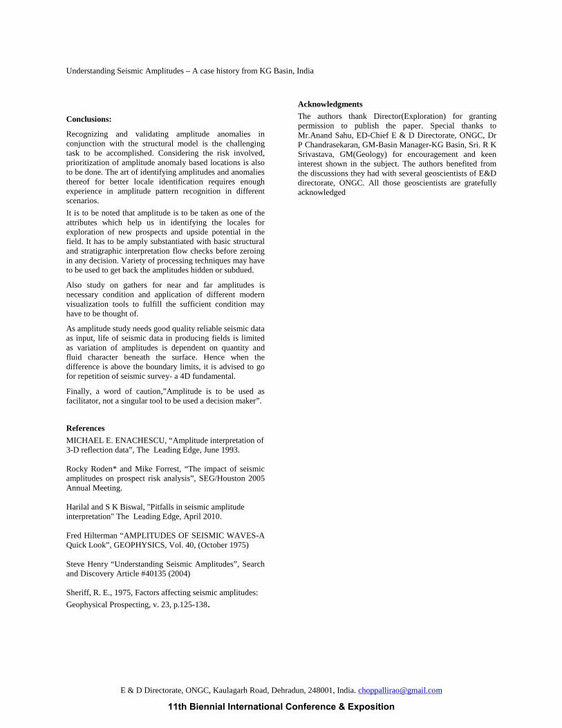
Fig:6 :Wells showing amplitudes within cretaceous and having no HC shows.
Fig:7: :Wells showing amplitudes within cretaceous with HC shows.
Fig:8: :Wells showing amplitudes within Pliocene with HC results.
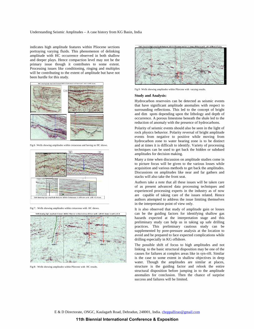
Fig:9 :Wells showing amplitudes within Pliocene with varying results.
Study and Analysis:
Hydrocarbon reservoirs can be detected as seismic eventsthat have significant amplitude anomalies with respect tosurrounding reflections. This led to the concept of brightand dim spots depending upon the lithology and depth ofoccurrence. A porous limestone beneath the shale led to thereduction of anomaly with the presence of hydrocarbons.
Polarity of seismic events should also be seen in the light ofrock physics behavior. Polarity reversal of bright amplitudeevents from negative to positive while moving fromhydrocarbon zone to water bearing zone is to be distinctand at times it is difficult to identify. Variety of processingtechniques can be used to get back the hidden or subduedamplitudes for decision making.
Many a time when discussion on amplitude studies come into picture focus will be given to the various losses whileacquisition and various methods to get back the amplitudes.Discussions on amplitudes like near and far gathers andstacks will also take the front seat.
Authors take a note that all these issues will be taken careof as present advanced data processing techniques andexperienced processing experts in the industry as of noware capable of taking care of the issues related. Henceauthors attempted to address the issue limiting themselvesin the interpretation point of view only.
It is also observed that study of amplitude gain or lossescan be the guiding factors for identifying shallow gashazards expected at the interpretation stage and thispreliminary study can help us in taking up safe drillingpractices. This preliminary cautious study can besupplemented by pore-pressure analysis at the location toavoid and be prepared to face expected complications whiledrilling especially in KG offshore.
The possible shift of focus to high amplitudes and notlinking to the basic structural disposition may be one of thecauses for failures at complex areas like in syn-rift. Similaris the case to some extent in shallow objectives in deepwater. Though the amplitudes are similar at places,structure is the guiding factor and relook the entirestructural disposition before jumping in to the amplitudeanomalies for conclusion. Then the chance of surprisesuccess and failures will be limited.
11th Biennial International Conference & Exposition
Understanding Seismic Amplitudes – A case history from KG Basin, India
E & D Directorate, ONGC, Kaulagarh Road, Dehradun, 248001, India. [email protected]
Conclusions:
Recognizing and validating amplitude anomalies inconjunction with the structural model is the challengingtask to be accomplished. Considering the risk involved,prioritization of amplitude anomaly based locations is alsoto be done. The art of identifying amplitudes and anomaliesthereof for better locale identification requires enoughexperience in amplitude pattern recognition in differentscenarios.
It is to be noted that amplitude is to be taken as one of theattributes which help us in identifying the locales forexploration of new prospects and upside potential in thefield. It has to be amply substantiated with basic structuraland stratigraphic interpretation flow checks before zeroingin any decision. Variety of processing techniques may haveto be used to get back the amplitudes hidden or subdued.
Also study on gathers for near and far amplitudes isnecessary condition and application of different modernvisualization tools to fulfill the sufficient condition mayhave to be thought of.
As amplitude study needs good quality reliable seismic dataas input, life of seismic data in producing fields is limitedas variation of amplitudes is dependent on quantity andfluid character beneath the surface. Hence when thedifference is above the boundary limits, it is advised to gofor repetition of seismic survey- a 4D fundamental.
Finally, a word of caution,”Amplitude is to be used asfacilitator, not a singular tool to be used a decision maker”.
References
MICHAEL E. ENACHESCU, “Amplitude interpretation of3-D reflection data”, The Leading Edge, June 1993.
Rocky Roden* and Mike Forrest, “The impact of seismicamplitudes on prospect risk analysis”, SEG/Houston 2005Annual Meeting.
Harilal and S K Biswal, "Pitfalls in seismic amplitudeinterpretation" The Leading Edge, April 2010.
Fred Hilterman “AMPLITUDES OF SEISMIC WAVES-AQuick Look”, GEOPHYSICS, Vol. 40, (October 1975)
Steve Henry “Understanding Seismic Amplitudes”, Searchand Discovery Article #40135 (2004)
Sheriff, R. E., 1975, Factors affecting seismic amplitudes:
Geophysical Prospecting, v. 23, p.125-138.
Acknowledgments
The authors thank Director(Exploration) for grantingpermission to publish the paper. Special thanks toMr.Anand Sahu, ED-Chief E & D Directorate, ONGC, DrP Chandrasekaran, GM-Basin Manager-KG Basin, Sri. R KSrivastava, GM(Geology) for encouragement and keeninterest shown in the subject. The authors benefited fromthe discussions they had with several geoscientists of E&Ddirectorate, ONGC. All those geoscientists are gratefullyacknowledged
11th Biennial International Conference & Exposition

E & D Directorate, ONGC, Kaulagarh Road, Dehradun, 248001, India. [email protected]
11th Biennial International Conference & Exposition