under lock and quay (800kb pdf) - canal & river trust · pdf fileunder lock and quay...
TRANSCRIPT

Under Lock and QuayReducing Criminal Opportunity by Design
A Guide toWaterside Development
and Improvementin London
����


Under Lock and Quay
Contents
1 INTRODUCTION 1
1.1 Purpose of Document ...................................................................................... 1
1.2 Scope and Aims of Document .......................................................................... 1
2 BACKGROUND 3
2.1 London’s Waterways Today.............................................................................. 3
2.2 Crime and Waterways ...................................................................................... 4
2.3 British Waterways’ Statutory Duties and Responsibilities .................................. 7
2.4 Role and Function of the Police Crime Prevention Design Team ........................ 7
3 RELEVANT POLICY FRAMEWORK 8
3.1 DoE Circular No 5/94 Planning Out Crime (February 1994) .............................. 8
3.2 Crime and Disorder Act 1998, Section 17......................................................... 8
3.3 Government’s recently announced Plans and Pledges for Inland Waterways ...... 8
3.4 Current Agenda 21 Initiatives ........................................................................... 9
3.5 Recent Government Publications on Sustainable Development and SustainableUrban Communities......................................................................................... 9
3.6 Recent London Waterway Initiatives ............................................................... 10
4 TYPES OF CRIME ENCOUNTERED 12
4.1 Types of Crime to be Addressed..................................................................... 12
4.2 The Causes of Crime...................................................................................... 14
4.3 Reducing Criminal Activity ............................................................................. 17
5 WATERWAY USE 19
5.1 Towing Path Users......................................................................................... 19
5.2 Waterway Users............................................................................................. 19
5.3 Problems and Solutions ................................................................................. 19
6 DESIGN GUIDELINES FOR WATERSIDE DEVELOPMENT 26
6.1 Residential Development ............................................................................... 28
6.2 Waterfront Mixed use Development ................................................................ 32
6.3 Industrial Development.................................................................................. 36
6.4 Moorings, Marina Developments and Associated Facilities.............................. 40
7 PUBLIC OPEN SPACE ADJACENT TO WATERWAYS 47
7.1 Towing Path Enclosure .................................................................................. 47
7.2 Key Design Requirements for Generating Natural Surveillance ........................ 48
8 DESIGN GUIDELINES FOR CREATING AND IMPROVING WATERWAY ACCESS 49
8.1 Access Points ................................................................................................ 49
8.2 Bridges ......................................................................................................... 51

Under Lock and Quay
Contents
9 WATERSIDE PLANTING, LIGHTING, FURNITURE AND HARD SURFACING 52
9.1 Planting .........................................................................................................52
9.2 Lighting .........................................................................................................54
9.3 Waterside Furniture........................................................................................56
9.4 Hard Surfacing...............................................................................................61
10 ROLE AND IMPORTANCE OF UNITARY DEVELOPMENT PLANS, LOCALIMPLEMENTATION PLANS, PLANNING APPLICATIONS, AND MAINTENANCEAGREEMENTS 65
11 MANAGING CRIME 68
12 COMMUNITY AWARENESS AND PARTICIPATION 70
13 CONCLUSIONS AND RECOMMENDATIONS 71
CONTRIBUTORS AND CONTACTS 72
Appendix 1: SUMMARY OF CURRENT CRIME PREVENTION LITERATUREAND INITIATIVES
Appendix 2 : BRITISH WATERWAYS GUIDANCE NOTE ON BRIDGE DESIGN

Under Lock and Quay
Foreword
British Waterways is responsible for 80 miles of canals,rivers and docks in London and some 2,000 milesnationally. London’s waterways are a unique resourcecontributing greatly to the quality of life of London as aplace to live, work, visit and enjoy and theyincreasingly act as a focus for regeneration anddevelopment.
Unfortunately, crime and anti-social behaviour havebecome a feature of society today and sadly thewaterway environment is no exception.
Through the successful collaboration between BritishWaterways and the Metropolitan Police, “Under Lockand Quay” provides guidance on the most appropriateand effective ways of designing out opportunities forcriminal activity and reducing fear of crime in bothexisting and new developments adjoining our urbanwaterways.
Mark BenstedLondon Regional Director
British Waterways
“Under Lock and Quay is both an informative andcomprehensive document providing a valuablereference for all professionals involved in watersidedevelopment and improvement. The guidance is basedupon sound research and reinforces the fact that crimenot only impacts upon people and buildings, but on awide variety of built environments. It is an excellentexample of how organisations can work in partnershipto defeat crime and I have no doubt that a continuedworking relationship between British Waterways andthe Police Service will result in safer and more securewaterway environments for everyone to enjoy.”
Michael ToddDeputy Assistant Commissioner
Chairman of the Association of ChiefPolice Officers
Crime Prevention by Design Group
This document was launched at the National Architectural Liaison Officers andCrime Prevention Design Advisors Conference on 4 May 2000. The printing of thisdocument has been supported by London’s Waterway Partnership.

Under Lock and Quay
Foreword

Under Lock and Quay
Foreword
London’s Waterways are an accessible cultural and environmental asset which alsoact as a catalyst for regeneration and inward investment. They are playing anincreasingly important role in the capital’s tourism industry as well as becomingpopular for residential, commercial and leisure development, all of which impactsubstantially on the patterns of movement along the waterways and the growingnumber of different users. There is a growing national awareness of the addedvalue and commercial betterment of development alongside water, and recent majorschemes have demonstrated the success and potential for future development.
There is a real opportunity to capitalise on this resource and British Waterways arestriving to improve access to, and enhance the vitality of, the waterway network. Itis important therefore that issues relating to crime and the fear of crime are tackledusing positive and long-term solutions which are in keeping with the built andnatural heritage of this historic transport network to encourage greater and safer useof waterside facilities.
Inland waterways are an integral part of London’s natural and industrial heritage aswell as having a vital social role to play through the provision of publicly accessibleareas for informal recreation and educational purposes. However, BritishWaterways and the Metropolitan Police recognise that the linear nature of thewaterways, particularly canals which have a limited number of crossing points, oftenresult in segregation of waterside areas from their surroundings and increasedopportunity for criminal activities to occur. It is often the fear of crime rather thanactual danger itself which discourages people from venturing along the towing path.
Safety and security issues are inextricably bound up with enhancement,conservation and development, yet addressing the problem is often done on anad-hoc basis once development is complete. This leads to ineffective andinappropriate treatment which can have two negative impacts upon the waterwayenvironment:
� creates an environment which can be inadvertently perceived as being unsafe; or
� changes the historic character of the waterway irrevocably as to make it lessdesirable to visit.
Therefore, British Waterways and the Metropolitan Police are of the view thatdesign measures to improve security should ideally be included at the planning stageas part of an integral approach to new development, regeneration, andenvironmental improvement schemes in order to design out crime.
British Waterways and the Metropolitan Police strongly believe that through gooddesign practice and good working relationships with local planning authorities anddesigners, the levels of waterside related crime can be substantially reduced.
“Under Lock and Quay” seeks to combine good waterside design practices andcrime prevention measures based on a clear understanding of the issues involved, aswell as the needs and concerns associated with the different users and uses ofLondon’s waterways. It also builds upon the wealth of literature issued individuallyby the Metropolitan Police and British Waterways regarding crime prevention andwaterside design respectively.

Under Lock and Quay
Foreword
“Under Lock and Quay” presents general design principles rather than absolutesolutions so as to be applicable across a wide range of sites and projects, and shouldbe read in conjunction with other relevant literature published by British Waterwaysand the Metropolitan Police. Examination of the problems and solutions affectingdifferent towing path and waterway users are presented in tabular form forconvenience.
The information contained within this document is aimed at local planningauthorities, developers, the Metropolitan Police and British Waterways, all of whomhave a vested interest in waterside safety and the success of waterside developmentschemes, and all of whom have direct influence on the design of such sites.
It is hoped that the London Boroughs will use this document as an advisorydocument in the preparation of development plan policies and development briefsand as a material consideration in the negotiation and determination of planningapplications.
This Document relates specifically to the crimes encountered along London’scanals and navigations, but the majority of problems and solutions proposed areapplicable to waterways in all inner city areas.
However, it should be noted that this document does not offer guidance for theRiver Thames corridor, where many of the problems and issues are of a verydifferent scale and scope.

Under Lock and Quay
Introduction1
1 INTRODUCTION
1.1 Purpose of Document
The purpose of this document is three fold:
� as an advisory document for the London Borough Councils whenpreparing development briefs and development plan policies forthe creation of safe, active, attractive and accessible watersidedevelopments which conserve and enhance the watersidecharacter;
� as a material consideration in the negotiation and determinationof planning applications by London Borough Councils;
� as a tool to assist developers and their design teams in designingwaterside developments which address the issue of crimeprevention at the initial design stages in order to successfullyreconcile the visual quality of a development with the need forcrime prevention to create sustainable development.
1.2 Scope and Aims of Document
The scope of this document is the water and land associated with London’scanals and navigations, excluding the River Thames. It is not restricted tothe area of land owned by British Waterways, but includes adjacent landand developments which impact upon the waterway corridor.
The document aims to:
� identify the nature of criminal activity along the waterways
� the causes of the crime and fear of crime
� provide guidance on the most appropriate and effective ways of dealingwith crime prevention in new and existing developments given theunique and historic context of London’s waterway corridors.
London’s waterways transcend the administrative boundaries of theLondon Boroughs and therefore consistency in the approach to design andcrime prevention needs to be achieved. It is hoped that each of the LondonBoroughs will adopt this document as Supplementary Planning Guidance.

Under Lock and Quay
Introduction2
Figure 1.1 : Plan showing the inland waterway network transcending a number of differentLondon Boroughs' administrative areas within British Waterways' London Region.

Under Lock and Quay
Background3
2 BACKGROUND
2.1 London’s Waterways Today
London’s waterways pass through a broad variety of landscape types fromtranquil parks and woodland to Georgian and contemporary residential andcommercial developments, as well as stark industrial areas.
Despite the rapid rise in development throughout the 1980s and 1990s, thecharacter of the waterways has largely been retained through planningcontrols (such as the listing of historic buildings and structures, thedesignation of Conservation Areas and Tree Preservation Orders), whichserve to protect important waterway features and promote the retention,refurbishment and re-use of historic buildings.
Waterway character has also been perpetuated through good designpractices, including:
� the careful conservation and integration of existing historic features intonew development schemes;
� the use of traditional materials and re-use of original site materials whereappropriate;
� attention to the scale of retained buildings and structures, in the designof new developments;
� appreciation of traditional architectural solutions to help overcome issuesof security, access, etc;
� preservation of the sense of enclosure and intimacy of the canal corridor.
Though there are obviously exceptions where large-scale development haschanged the character of a waterway in a positive way, the need to conservecharacter and heritage must be a primary consideration to all waterwaydesign and development proposals, from both aesthetic and operationalperspectives.
Crime prevention measures should reflect the character of the environmentor building to which they relate and be designed in such a way that they donot compromise the specific waterway requirements.

Under Lock and Quay
Background4
2.2 Crime and Waterways
Crime is a common occurrence throughout the country and is associatedwith all types of development from residential through to commercial uses,public open spaces and private property alike. Whilst the nature of criminalactivity is comparable in all these situations, the causes, frequency andseverity of criminal activity may vary significantly.
This document concentrates specifically on criminal activity in associationwith London’s urban waterway network, where the towpaths and associatedspaces often create an environment suitable for crime.
On initial investigation of police records, it appears that crime along thewaterways is relatively minor when compared to that experienced inadjacent areas. However, police records will not always reflect true levels ofwaterside related crime due to under reporting and the method by whichcrimes are reported.
Firstly, levels of crime are based solely on those incidences which arereported to the Metropolitan Police, and more often than not offences suchas graffiti, threatening behaviour and vandalism are never reported.
Secondly, offences such as burglary of buildings adjacent to the waterside,where access is gained from the towing path, will normally be recorded bythe street address rather than by waterside location. The relationshipbetween the crime and the access point is therefore less apparent.
Finally the information recorded may be biased in favour of a particularcrime, for example, drug dealing. This is not a true assessment of the typeand volumes of crime occurring at a site but a reflection of MetropolitanPolice commitment to clear away the drug problem.

Under Lock and Quay
Background5
Figure 2.1 : Images of London's Waterways

Under Lock and Quay
Background6
Under Lock and Quay
Background7
2.3 British Waterways’ Statutory Duties and Responsibilities
British Waterways' own and manage the Grand Union Canal, PaddingtonArm, Regents Canal, Lee and Stort Navigations as well as the Isle of Dogswaterspace.
British Waterways has statutory duties to maintain the structural integrity ofthe waterway network and to maintain water levels for navigation purposes.It also has duties under the British Waterways Act, 1995, to protect andsafeguard the heritage and environment of the inland canal and rivernavigations. This Act also places general environmental and recreationalduties, including public access, on British Waterways.
British Waterways was granted statutory consultee status for planningapplications in July 1997 and has a direct interest in all watersidedevelopment.
In 1999, British Waterways launched a major public consultation to helpdetermine the future direction of the national waterway network. Thissought to establish “Partnership with the People” and suggested a newWaterway Trust could be formed to help guide and fund new waterwayinitiatives. The role of many potential partners, both public and private,will therefore be important in the future development of British Waterways.
2.4 Role and Function of the Police Crime Prevention DesignTeam
Crime Prevention Design Advisors (CPDA) and Architectural LiaisonOfficers (ALO) are experienced police officers specialising in therelationship between crime and the environment. There is a CPDA orALO appointed to every regional police force, each with invaluableknowledge of criminal activities within the area, as well as access to criminalanalysis programmes.
It is the role of the CPDA and ALO to encourage professionals such asarchitects and local authority planners to tackle crime in a structured way atthe design stage when it is most effective in terms of cost and crimereduction.
The CPDA and ALO are able to supply a developer with a crime profileand demographic knowledge of a site.
A summary of current crime prevention literature and initiatives aredescribed in Appendix 1.

Under Lock and Quay
Relevant Policy Framework8
3 RELEVANT POLICY FRAMEWORK
British Waterways and the Metropolitan Police have produced thisdocument to guide the London Boroughs in light of the followinglegislation, policy statements and initiatives.
3.1 DoE Circular No 5/94 Planning Out Crime (February 1994)
This circular gives advice to local authorities, developers and designersabout planning considerations relating to crime prevention. The circularstresses that once a development has been completed, the mainopportunity to incorporate crime prevention measures has been lost.Furthermore, this circular advocates crime prevention is capable of being amaterial consideration in the determination of planning applications.
3.2 Crime and Disorder Act 1998, Section 17
Section 17 requires all local authorities, including joint authorities, PoliceAuthorities, National Park authorities and the Broads Authority to considercrime and disorder reduction while exercising all their duties.
Furthermore, this places a statutory requirement on local authorities (andthe police with other agencies and the community) to work together atdistrict level to develop and implement strategies for reducing crime anddisorder in the area.
Although, British Waterways has no statutory requirement placed upon theorganisation, British Waterways is committed to work with the Londonboroughs and the Metropolitan Police to reduce crime and disorder alongwaterways. British Waterways is also committed to developing both publicand private partnerships and intends to extend its "partnership approach"with the voluntary sector to bring improvements to and promote the safeuse of London's waterways.
3.3 Government’s recently announced Plans and Pledges forInland Waterways
The Deputy Prime Minister, John Prescott, recently expressed the view thatinland waterways:
“have enormous potential not only for contributing to an integrated transportsystem, but also as a catalyst for urban and rural regeneration and for stimulatingleisure and tourism” and “we need to ensure that British Waterways is best placedto unlock the potential of the waterways”.
In the Government’s recent paper “Unlocking the Potential …. A NewFuture for British Waterways” inland waterways are seen as valuable part ofthe national heritage. The Government is committed to ensuring that theyare recognised as a valuable public asset and that their full potential issecured.

Under Lock and Quay
Relevant Policy Framework9
3.4 Current Agenda 21 Initiatives
The London Boroughs have been developing Local Agenda 21 programmesto achieve a more sustainable pattern of development for the next century,following the British Government signing the declaration at the UnitedNations’ Conference on Environment and Development (the EarthSummit) held in Rio de Janeiro in 1992. Some London Boroughs haveestablished task forces to consider Agenda 21 issues and to develop a seriesof action plans including schedules of indicators, in order to provide acomprehensive borough-wide programme of action. Protection,improvement and re-use of urban waterways are being included as actionswithin emerging action plans.
3.5 Recent Government Publications on SustainableDevelopment and Sustainable Urban Communities
The Government is committed to an urban renaissance. National planningguidance and other policy statements focus and emphasise the importanceof the following principles in contributing to the achievement of sustainabledevelopment and sustainable urban communities:
� Urban regeneration and the re-use of under-utilised urban land, water,and buildings, and previously developed urban land (particularly forresidential use);
� Improving the quality of life through the creation and improvement ofurban neighbourhoods. Revitalisation of urban areas to create attractiveplaces to live and foster a strong sense of community as well as publicsafety;
� Improvement of the quality of the built environment and adoption of keyurban design principles;
� Protection of open spaces with recreational and amenity value in urbanareas and urban fringe areas;
� Conservation of the historic, natural and water environment;
� Importance of protecting, promoting and enhancing local distinctiveness;
� Fully integrated transport systems, promoting alternative sustainablemodes of transport to road transport, making it easier and safer to walkand cycle, as well as providing “Access for All”. The Government hasbeen promoting the role of the inland waterways, to be fully consideredin relation to cycling, walking, public transport (eg waterbuses), accessfor disabled people, as well as freight transport.
� Concept of mixed use development which generates natural surveillanceand policing;
� High quality design for new development and refurbishment of existingbuildings;
� Importance of planning and designing out crime.
British Waterways and the Metropolitan Police recognise that thereshould be a balanced approach to design which attempts to reconcilethe visual quality of a development with the need for crime

Under Lock and Quay
Relevant Policy Framework10
prevention. It is very important that crime prevention measures donot have an adverse affect on the historic fabric and environment ofLondon’s waterways.
3.6 Recent London Waterway Initiatives
In recent years, a number of initiatives have developed to promote andimprove London’s waterways as a safe and attractive public amenity.
The London Canals Committee was established in 1966 as a co-ordinatingbody for canalside matters. It is made up of nine canalside Boroughstogether with British Waterways, Lee Valley Regional Park Authority,Inland Waterway Association and other canal interest organisations. TheCommittee promotes the development of London’s canals and canalside forrecreation, navigation and related activities consistent with its continuedcommercial use. Canalside Boroughs have undertaken works to improve theenvironment and accessibility of the canal network.
More recently London’s Waterway Partnership has been established toco-ordinate the seven year London-wide Single Regeneration Budgetinitiative 1997 – 2004 "London's Waterways, A Catalyst for Regeneration"for the improvement of London’s waterways.
London’s Waterway Partnership is a London-wide strategic alliance of thepublic and private sector centred on 50 miles of canal and river corridor.
“The Partnership’s shared vision is that London’s waterway network becomes afocus for economic and environmental regeneration, linking centres of vibrantcommercial activity with areas of urban tranquillity and open space, building onthe existence of a rich and varied working waterway heritage.”
The partners include:� British Waterways� Environment Agency� Lee Valley Regional Park
Authority� London Tourist Board
� Groundwork� Thames Water� 15 London Boroughs� A wide range of other private,
voluntary and public sectororganisations
The five key themes of the SRB initiative are:� “Developing Business and Employment Opportunities”� “Developing Tourism and Leisure”� “Addressing the Quality of the Water Corridor”� "Focussing on Local Communities" to generate community pride and
ownership in order to increase security and reduce vandalism, enhancethe visitor experience and support tourism development. Theprogramme concentrates on three main areas:� Education and Delivering Skills;
� Community Capacity Building Initiatives;

Under Lock and Quay
Relevant Policy Framework11
� Community Safety Awareness looks at waterside stretches whichpeople consider difficult or threatening. Areas along the Regent’sCanal will be redesigned to improve people’s sense of security.
� “Creating Strategic Links” – landscapes and boundaries, security andaccess will feature prominently within this programme.
In parallel with the work of London’s Waterway Partnership, BritishWaterways have prepared a number of detailed actions plans and canalcorridor studies to identify a range of improvements and initiatives alongthe capital’s waterways. Examples include the London Borough of EnfieldStudy and a detailed Action Plan for the Regents Canal. These studies helpto identify partners and funding and include examples of proposals anddesign ideas. British Waterways is also working closely with otherregeneration teams and strategic action plans for Kings Cross and HackneyWick have been prepared to support locally focussed SRB projects. Thesestudies act as catalysts for the improvement of the waterways, with a keyobjective being a safe, attractive and well planned environment for localsand visitors alike. Further such work is planned, and will compliment thisdocument.
A number of canal focus groups are developing within London. BritishWaterways, local authorities, the Metropolitan Police, Groundwork andcommunity interest organisations and representatives meet to considerissues and actions associated with opportunities to improve and protect thecanal and its environment. An example is the Friends of Regents Canal –Camden focus group. Priorities for action have been guided by acommunity safety and crime audit for the canal undertaken by the CrimePrevention Design Advisor. The audit has included recommendations forreducing crime and reducing fear of crime, for example by the designing outof hidden corners and the introduction of windows on the waterway plusthe removal of features such as graffiti which gives the impression to avisitor/user that the area is uncared for, unsupervised and antisocialactivities are taking place unhindered.
Also arising from such focus groups are “Adopt-a-Canal” and “WaterwayWatch” schemes where the local community, working closely with BritishWaterways, looks after and helps to improve particular stretches ofcanalside. This work has included training opportunities for youngunemployed. Through the Thames 21 Initiative action teams from theprobation service are also getting involved in canalside improvementsfocusing on reducing fear of crime and, at the same time, enabling thedevelopment of a more responsible attitude and understanding ofenvironmental management and community safety issues. This initiative isfunded by the London Waterways Partnership.
Access for people with disabilities is now incorporated within BritishWaterways’ corporate policy and as a result British Waterways is working inpartnership with the Field Fare Trust to develop new initiatives and haveproduced a guidance document entitled “Waterways Access for All” whichapplies waterways access for all principles in the context of good designpractice, heritage management and environmental code of practiceappraisals.

Under Lock and Quay
Types of Crime Encountered12
4 TYPES OF CRIME ENCOUNTERED
This chapter examines the broad areas of criminal activity which affectLondon’s waterways, whom they affect, why they occur and the factorswhich need to be considered in relation to the specific qualities andrequirements of the waterway environment. It concludes with four basicobjectives which can significantly minimise the problems associated withexisting and potential levels of waterway crime.
4.1 Types of Crime to be Addressed
The nature, frequency and severity of criminal activity will be partiallydependent on the character, location, reputation and use of the site/stretchof waterway itself, and may vary at different times of day.
Although figures are not specifically available for waterways, it should benoted that only 15% of criminal acts are pre-planned, with the remaining85% being opportunistic.
The nature of criminal activity to be considered can broadly be divided intotwo categories.
� Crime Against Property
Such crimes include:
� anti social behaviour
� vandalism/wilful damage
� graffiti
� arson
� theft
� burglary
� illegal tipping
� Crime Against Persons
Such crimes include:
� mugging/assault/rape
� theft
� threatening and anti socialbehaviour
� indecent exposure
Under Lock and Quay
Types of Crime Encountered13
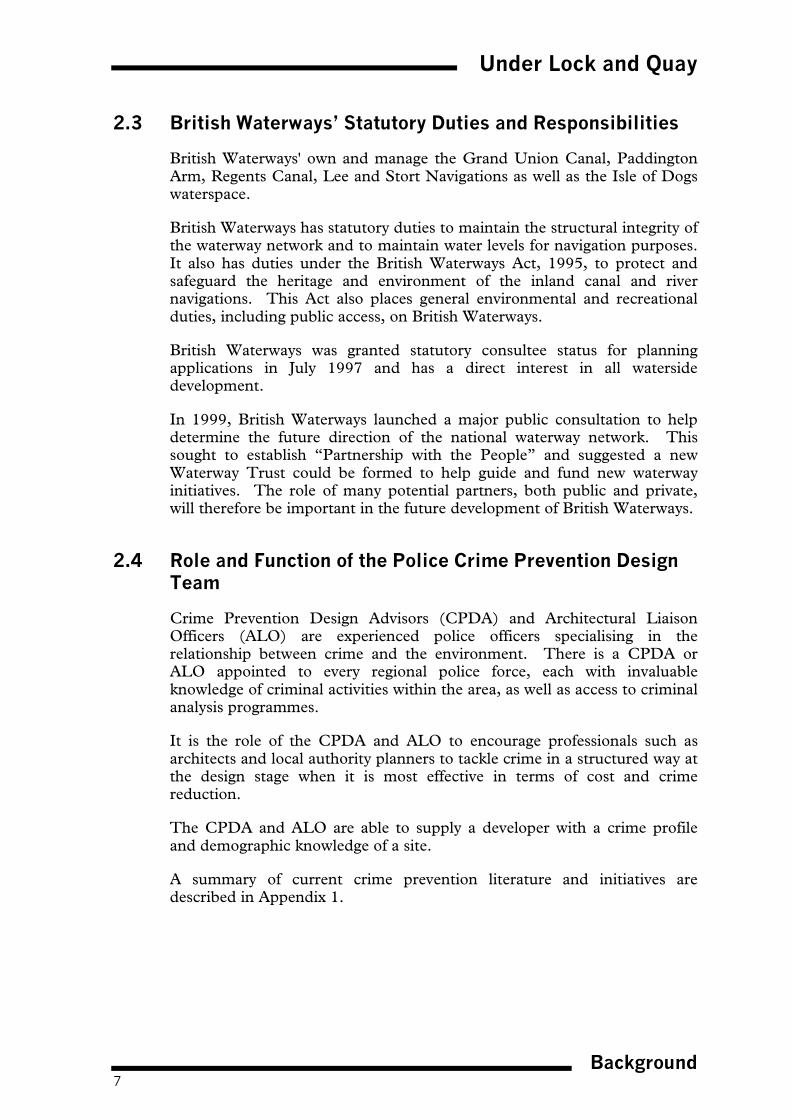
Figure 4.1 : Examples of Graffiti

Under Lock and Quay
Types of Crime Encountered14
4.2 The Causes of Crime
In order to appreciate the reasons which lead to criminal activity, it isimportant to understand the crime equation as illustrated below:
The diagram shows that if a crime is to be committed, there needs to be apotential target or victim, an offender and an opportunity. By removingone of these three factors, a crime cannot be committed.
The tables contained in Chapter 5 illustrate the relationship between theenvironment, victim and offender.
Opportunities for crime adjacent to waterways can present themselves in anumber of ways, and the following illustrations show some typicalexamples:
Figure 4.2 : Blind Spots
Blind spots where the offender can lurk unnoticed egvegetation, dog legs, tunnels and derelict buildings,dark corners, recesses and shaded areas.
OPPORTUNITY TARGET/VICTIM
OFFENDER
CRIME

Under Lock and Quay
Types of Crime Encountered15
Figure 4.3 : Confined or Restricted Spaces
Confined or restricted spaces where victims have littleor no option for escape eg towing paths and narrowalleyways with limited crossing points.
Figure 4.4 : Isolated Areas
Isolated areas that lack informal surveillance andallow the offender to unlawfully enter a property, tipunwanted material and vandalise property unnoticed.

Under Lock and Quay
Types of Crime Encountered16
Figure 4.5 : Misuse of Site Materials and Surfaces
Site materials and features such as loose coping andpaving, hanging baskets that are easily dismantled andcan be used as missiles or surfaces which are ideal forgraffiti.
Figure 4.6 : Poorly Maintained, Vacant or Derelict Sites andBuildings
A poorly maintained or derelict site may be perceivedas dangerous and therefore avoided by potential siteusers. Lack of informal site surveillance may result ina rapid decline resulting in increased opportunity forcriminal activity.
By addressing the issues illustrated it is possible to begin to remove or atleast take control of the opportunity for crime and thus reduce thefrequency with which criminal activity occurs on London’s waterways.

Under Lock and Quay
Types of Crime Encountered17
4.3 Reducing Criminal Activity
In order to reduce the opportunities for criminal activity and the fear ofcrime, the following four objectives must be considered in relation toLondon’s waterways:
� Ensure the waterway user is comfortable in the Environment
For example, this can be achieved by:
� Giving the waterway and towing path user full visual surveillance andawareness of the waterway corridor;
� Creating waterside spaces and environments that are user friendly andin which a visitor feels confident and comfortable;
▪ Creating sufficient numbers of clearly marked or visible access pointsand bridges.
� Ensure High Levels of Visual Surveillance along the Waterway
Informal surveillance by waterside users, boaters, anglers, passers by,adjacent residential and business users
Organised yet informal surveillance through schemes such asneighbourhood watch, boat watch etc.
� Instil a Sense of Ownership/Understanding of the WaterwayEnvironment
Much criminal activity, eg vandalism, graffiti and wilful damage, resultsfrom a lack of interest and respect for the waterway environment.Community action groups which actively work towards improving thewaterway environment can help create a sense of local ownership andpride which can potentially reduce the levels of criminal activity. Thereare already many such groups with a keen interest in London’swaterways and their enthusiasm should be encouraged. Both BritishWaterways and the Metropolitan Police undertake educationprogrammes in conjunction with schools.
� Remove the Means to Commit the Crime
Land uses adjacent to London’s canals are extremely varied and canunfortunately form a source of materials used by criminals or offenders,eg bricks, metal posts, graffiti tolerant walls, inflammable structures andpoorly maintained paving. Through careful selection of site furnitureand materials, as well as increased liaison with landowners andbusinesses, the incidence of vandalism and damage may be substantiallyreduced.
Under Lock and Quay
Types of Crime Encountered18
Using these four objectives, the following methods of combating waterwaycrime are discussed in subsequent chapters.
� Appropriate design solutions for different waterway and towing path usergroups as well as for different types of waterway structures and furniture(Chapter 5)
� Tackling crime through the design and planning process (Chapters 6-9)
� Managing crime (Chapter 10)
� Tackling crime through community awareness and participation(Chapter 11)
� Tackling crime through site maintenance/management.
Although there is an element of overlap between each, and a combinationof all five methods may ultimately prove the most effective way of reducingthe problem of waterway crime, this document concentrates on themethods of tackling crime through the design and planning process.
Chapters 6-9 are not intended to provide absolute solutions to a particularcrime problem, but set out design principles which can be applied across awide variety of sites and development types.

Under Lock and Quay
Waterway Use19
5 WATERWAY USE
As the use and function of London’s waterways has changed, the range ofwaterway users has correspondingly changed and grown. A broadindication of today’s users is outlined below:
5.1 Towing Path Users
� pedestrian commuters travelling toand from work
� hikers/walkers/joggers
� dog walkers
� cyclists
� anglers
� tourists
� shoppers
� naturalists
� historians
5.2 Waterway Users
� residential boaters
� long term moorers
� short term/visitor moorers
� rowers and canoeists
� trip boats and ferries
� restaurant, retail, hotel andconference boats.
5.3 Problems and Solutions
The following tables examine:
� each waterway user group’s specific requirements, the security issuesencountered and appropriate design solutions to overcome theseassociated problems (pages 20-21);
� waterway structures and furniture, their impact upon users, problemsencountered and appropriate design solutions to overcome theseassociated problems (pages 22-25).

Under Lock and Quay
Waterway Use20
USER GROUP USER REQUIREMENTS
TOWING PATH USERS
Walkers,dog walkers, naturalistsand bird watchers
� Attractive environment in which to walk, open spaces,medium and long distance views
� Peace and tranquillity
Anglers� Quiet location, lack of disturbance
� Medium and long distance views
� Space to set up equipment
� Good fish stocks
Recreational cyclists� Sufficient width of towing path to allow cycling
� All-weather surface to towing path
� Ease of access to and from the towing path
Commuters, tourists,shoppers
� All-weather surface to towing path
� Ease of access to and from the waterside
WATERWAY USERS
Visiting Boaters� Safe place to moor craft, perhaps overnight
� Ease of access to local facilities eg pubs, restaurants,shops
� Ease of access to waterway facilities eg sanitary stations,pump out, diesel supplies
Long term moorers (boatsmoored for casual andinfrequent use)
� Safe place to moor craft and leave unattended for longperiods
� Ease of access to waterway facilities eg sanitary stations,pump out, diesel supplies
Residential Boaters� Degree of privacy and tranquillity without formal
segregation
� Attractive home environment
� Ease of access to local facilities eg shops etc.
� Ease of access to waterway facilities eg sanitary stations,pump out, diesel supplies

Under Lock and Quay
Waterway Use21
PROBLEMS ENCOUNTERED SOLUTION
� Walkers and anglers frequentisolated locations with lack ofsurveillance and means ofsummoning help
� Frequent access points and signage from towingpath to local areas
� Information boards and maps indicating accesspoints, walkers location, nearest public phone etc.
� Walkers and anglers frequentisolated locations with lack ofsurveillance and means ofsummoning help
� Space for anglers to set up equipment separatefrom the main line of the towing path
� Close proximity of car parking facility
� Theft of bicycles from destinationpoints
� Provision of vandal proof cycle racks in areas ofhigh visual surveillance
� Use of towing path after dark � Light key areas of the towing path where pedestrianactivity is high and ambient lighting is low
� Ensure mixed use development to surrounding areato maximise surveillance
� Visiting boaters may frequent highrisk sites where they are unawareof potential danger
� Unauthorised access to boats,vandalism and theft
� Locate moorings where visual surveillance is higheg adjacent to residential area or residential boats
� Light moorings
� Install signage to local facilities
� Unauthorised access to boats,vandalism and theft
� Ensure high levels of visual surveillance by sitingmoorings adjacent to residential boaters oradjacent to residential and mixed use development
� Boats are usually mooredadjacent to towing paths andtherefore easily accessed by thegeneral public
� Boats are susceptible to attackdue to low level security
� Ensure high levels of visual surveillance by groupingresidential boats together or siting adjacent toresidential development (mixed use developmentsare not always appropriate due to noise levels) topromote mutual and natural surveillance betweenboats and residential dwellings
� Look at opportunities for locating residentialmoorings on offside of waterway

Under Lock and Quay
Waterway Use22
USER GROUP USER REQUIREMENTS
WATERWAY STRUCTURES
Locks and sluices� Unrestricted access to lockside for boaters i.e. no railings
to waters edge
� Mooring for craft waiting to access lock
� Sufficient space for siting and maintenance of lockmachinery
Marinas and mooringbasins
� High levels of security
� Good boaters facilities eg sanitary station, washing/dryingfacilities etc.
� Tranquil environment
� Access to local facilities
Sanitary stations� Clearly visible from the waterway
� Easy access for boaters from the waterside
� Reserved mooring for boats using the facility
Waterside car parks� Sufficiently close to the users waterside destination and to
provide visual surveillance from the waterside withoutcreating unattractive views from the waterway

Under Lock and Quay
Waterway Use23
PROBLEMS ENCOUNTERED SOLUTION
� Interference and damage to lockequipment
� Potential safety risk topedestrians due to lack ofwaterside railings
� Install lighting to lock area
� Locate operational equipment away frompedestrian access points
� Where possible restrict pedestrian access outsideoffice hours eg install lockable gates to overbridgeswhich can only be opened by BW key holders
� Locate harbourmasters buildings where requiredadjacent to locks for surveillance
� Unauthorised access to boatersfacilities
� Vandalism, damage and theftfrom vacant boats
� Theft and vandalism of moorersvehicles
� Maximise visual surveillance of the marina/basin.For larger marinas, consider the appointment of alive-in site manager. Smaller marinas/basins maybe sited within existing or proposed residentialareas. All marinas should carry a mix of mooringtypes including residential boats which providepermanent surveillance
� Implement discreet security controls eg swipe cardaccess to marina/basin site from main access road,with separate car parking facility for visitors.Locate moorings on finger pontoons away frommarina edges preferably off single arm with swipecard access
� Locate car parking facilities in small groups close totheir associated moorings with good visualsurveillance
� Unauthorised use of facilities
� Vandalism to building andfacilities
� Potential hiding place foroffenders and undesirables
� Restrict access through use of swipe cards
� Design building carefully to reduce potential forhiding places (refer to the Public ConveniencesProblem Reduction Guide)
� Locate facilities where visible from wide area oradjacent to marina manager or harbour mastersquarters
� Install lighting to improve visibility at night
� Vandalism and theft ofunattended vehicles
� Attacks on pedestrians returningto their vehicles particularly afterdark
� Refer to guidance set out in the Secure Car ParksAward Scheme
� Improve visual surveillance of the car park. Forlarge car parks introduce on site manager
� Site car parks close to areas of pedestrian activityand introduce low level planting to partially screencars from waterside
� Introduce lighting to heavily used car parksparticularly those associated with commuteractivity

Under Lock and Quay
Waterway Use24
USER GROUP USER REQUIREMENTS
Bridges and tunnels � Many are historic and/or listed structures to be retainedand conserved
� Provision of amenity lighting to adequately illuminate thetowing path and bridge undercrofts
Benches � Located at appropriate intervals and at key viewing pointsalong the waterside
Litterbins � Located in areas of high pedestrian activity in associationwith retail and food outlets
Lighting � Of sufficient lux level to achieve desired effect whilstminimising glare to surrounding area

Under Lock and Quay
Waterway Use25
PROBLEMS ENCOUNTERED SOLUTION
� The abutments of bridges andtunnels are blind spots whereoffenders lurk unnoticed
� The dark nature of such structurescompounds the limited visual rangeof the site user
� Graffiti and vandalism
� Location of other undesirableactivities
� Improve visibility and reduce the potential foroffenders to lurk, through the careful siting of newbridges and tunnels and the design of abutments
� Reduce the opportunity for offenders to lurk at theblind spots of existing bridges and tunnels throughthe planting of thorny shrubs
� Install lighting to the offside of bridges and tunnelswhere necessary (see below)
� Where structures are painted introduce graffitiresistant paint, alternatively retain a rough surfacefinish to the structure to deter graffiti. Wherelisting of a structure preculdes any changes inmaterials, implement a thorough maintenance andmanagment regime to keep the structure clean
� In areas where the nature and level of crime issevere, consider restricting access beneath thebridge and through the tunnel after dark
� Vandalism
� Arson
� Graffiti
� Misuse by vagrants
� Reduce levels of vandalism through specificationof fire resistant materials and anti graffiti surfaces.Specify quality products that aredifficult/impossible to dismantle
� Keep benches and seating to a minimum to reducepotential to misuse
� Avoid misuse through the specification of singleseats, curved benches, backless seats and armrests across the centreline of long benches
� Potential for concealing incendiarydevice
� Arson
� Specify litterbins only where absolutely necessaryand ensure that if needed they are of sufficientcapacity to accommodate expected litter levels.Ensure that servicing of litterbins is sufficient tomeet litter requirements
� Omit bins altogether in high profile areas
� Bins to be constructed using fire resistantmaterials and anti graffiti paint and of sufficientquality that dismantling is difficult/impossible
� Vandalism
� Encourages people to use areas ofthe waterside which are potentiallydangerous even when lit
� Reduce potential vandalism by locating lighting tounderside of bridges and tunnels on the offsideand use recessed lighting attached to buildings orwalls or set into the towing path
� Use lighting only where absolutely essential egbusy commuter routes where there is additionalsite surveillance.

Under Lock and Quay
Design Guidelines for Waterside Development26
6 DESIGN GUIDELINES FOR WATERSIDE DEVELOPMENT
The unique qualities of the built and natural heritage of London’s waterwaycorridors means that measures to improve site security and safety should betailored to meet the specific requirements of each individual site.
It should never be assumed that a successful solution can beuniversally applied. Neither should it be assumed that the samesolution to a particular problem is appropriate along an entirewaterway or even a selected length.
By its very nature, London’s waterway network is linear in character with alimited number of crossing points and is often segregated from existing roadand footpath networks. It is frequently perceived as a private environmentnot really designed for free and easy public access. Therefore, for thepotential of the waterway to be fully exploited, this perception needs tochange and new development often provides the opportunity.
Development of land adjacent to London’s waterways needs to adopt the keyurban design principles of permeability, variety, vitality, legibility, visualappropriateness and richness to create accessible, safe and attractiveenvironments which:
� have a strong sense of place, and create safe and active edges to thewaterside;
� respect the townscape and topography, relate to the waterside andcontinue to promote the human scale of the waterways;
� ensure pedestrian comfort and easy access to facilities.
The principles of good urban design should extend onto the waterway itselfand future waterside development needs to ensure that any new developmentis considered holistically with the opportunities for waterbased residential,leisure and commercial development to ensure life and vitality to thewaterspace and towing path. The opportunities to create or extend mooringbasins and marinas as well as to utilise the waterway by introducingresidential and visitor moorings, trade boats and floating restaurants whichalso generate natural surveillance and policing of both the waterspace and theadjacent development should always be considered. These improvementsand facilities could be secured through planning obligations.
Emphasis needs to be placed on site planning, design layout and orientationto solve problems of security and safety. The following qualities are requiredto ensure that any new building will fit harmoniously into any waterwaycorridor and thus should form the basis for any assessment criteria.
Siting and Orientation of new buildings should positively address thewaterway. The height of buildings needs to be related to the set back fromthe water’s edge to achieve a sense of enclosure without being oppressive orintimidating.

Under Lock and Quay
Design Guidelines for Waterside Development27
Massing relates to the height, bulk and silhouette of a building. The heightof a new building should respect the height of existing waterside buildingsand its bulk should not greatly exceed the bulk of adjoining watersidebuildings.
Scale any new waterside building must be of human scale at ground leveland should respect the scale of existing waterside buildings and the waterwayitself.
Barriers and boundary treatments are used to define all external spacesand are often the single most important design detail affecting the use of asite and associated levels of criminal activity. For example, the design andlocation of a boundary treatment or barrier will affect:
� the area which can be seen by the public
� the ease with which offenders can unlawfully enter a building or property
� the level of site surveillance from adjacent land or properties
� the visitors perception of the waterway corridor.
Furthermore, the form of a boundary or barrier will be dependent upon itsfunction. The design of waterside boundaries will be influenced by:
� the function of the boundary
� the character of the site
� the nature of criminal activities occurring at the site
� existing boundary treatments in the area.
It is important that all these factors are considered in relation to London’swaterways and their surrounding uses, in order to:
� retain waterside character
� reduce the need for excessive security measures
� increase the levels of visual surveillance
� reduce opportunity for unlawful entry into property.
Siting and orientation of new development, appropriate boundarytreatment and access issues are often different for the towing pathside from the offside.
The following sections examine four waterside development types and theappropriate use of orientation, massing, form and boundary treatment inrelation to their waterside setting on both the towing path side and theoffside:
� residential development
� waterfront mixed use development
� industrial development
� moorings, marina developments and associated facilities.

Under Lock and Quay
Design Guidelines for Waterside Development28
6.1 Residential Development
There is a growing national awareness of the added value and commercialbetterment of waterside residential developments. A study by Willis &Garrod at the University of Newcastle, in March 1994, revealed that newresidential property built by the water commands a 19% premium value overand above that of equivalent property elsewhere. This premium extends toproperties at some distance away from the water. Therefore, there issubstantial potential to promote waterside brownfield sites in urban areas forresidential development.
London’s waterways can contribute to raising the density of development byintroducing:
� high density waterside residential developments as the built formrelationship with historic urban waterways tend to be characterised bydense urban grain and strong sense of enclosure created by four to sixstoreys high buildings
� permanent residential moorings as part of waterside residentialdevelopment.
High density requires good urban design, therefore, emphasis needs to beplaced on site planning, design layout and orientation to solve problems ofsecurity and safety.
Siting and orientation of dwellings, appropriate boundary treatment andaccess issues are different for new waterside residential schemes on thetowing path side than from new schemes on the offside.
Towing Path Side
Rear and side elevations of dwellings and rear and back gardens frontingonto the towing path and the waterway create inward looking development,which makes limited use of the waterside frontage and therefore minimisesopportunities to generate natural surveillance and policing. Extensive lengthsof fencing and car parking areas fronting the waterway are consideredinappropriate.
All new residential development should be orientated to positively addressthe waterway on the towing path side in order to create an attractive,interesting and active frontage to the waterway, which would generate naturalsurveillance and policing. Introduction of front doors or balconies onwaterside elevations can generate natural surveillance and policing of thetowing path.
The most appropriate design approach is to consider residential developmentwith secured and overlooked rear service and parking areas with semi-privateaccess to the frontage for waterside developments.

Under Lock and Quay
Design Guidelines for Waterside Development29
Figure 6.1 : Sketch illustrating residential development positively addressing awaterway and generating natural surveillance and policing of the waterspace.
New waterside residential developments on the towing path side shouldinclude the creation and improvement of existing access points to the towingpath and the improvement of the towing path itself for pedestrians andcyclists as an integral part of the scheme.
Figure 6.2 : Photograph illustrating the creation of an access point to the towing pathas an integral part of the residential development.

Under Lock and Quay
Design Guidelines for Waterside Development30
Generally waterside residential development should avoid the construction ofroadways adjacent to the waterway. However where the site configurationrequires the construction of roadways adjacent to the waterway, then it isimportant that:
� the layout does not result in the dwellings being set too far back from thetowing path and water’s edge beyond thus divorcing the development fromthe waterway. This arrangement will destroy the visual and physicalrelationship between the dwellings and the water’s edge resulting in thetowing path not being overlooked;
� any access road constructed adjacent to the waterway should incorporate thetowing path and its environs as an integral part of the scheme e.g. an informalshared surface, where appropriate incorporating the towing path to amaximum width of 4 metres. The access road and towing path should beboth paved in a material sympathetic to the setting.
Figure 6.3 : Photographs illustrate how the effect of incorporating and excluding thetowing path as an integral part of the scheme can encourage and discourage the useof the towing path.
�
�

Under Lock and Quay
Design Guidelines for Waterside Development31
Offside
All new residential development should be orientated to front the waterwayon the offside wherever possible. However, where the configuration of a siteon the offside does not permit the houses to be orientated to front thewaterway, then it is crucial that:
� there should be no walkway to the rear of residential properties. This willenable the waterway to act as a “moat” to back gardens. It is important toensure that the water edge areas are “owned” to avoid security problemsas well as problems of neglect;
� inherent conflict between the waterway (which by its nature is part of thepublic realm) and back gardens onto the waterside, which function formost people as a private secluded outdoor space, is resolved.
In these cases boundary design is very important. Full height walling orfencing installed by a developer or in the future by the householders isconsidered to be inappropriate boundary treatment for such an environment.
Use of imaginative landscaping and level changes to create waterside terraceswith the option of private moorings is one example of a design concept whichachieves rear garden privacy as well as an attractive water frontage. Awaterside terrace could contribute to the vitality of the waterway corridor andprovide an attractive view of the residential properties from the towing path.Any private moorings would however require British Waterways’ agreement.
Figure 6.4 : Photograph illustrates inappropriate siting and orientation of dwellingsas well as inappropriate boundary treatment in a waterway setting. The boundarytreatment generates low levels of natural surveillance and policing and devalues thewaterway environment for all users.

Under Lock and Quay
Design Guidelines for Waterside Development32
New waterside residential developments on the offside should consider bridgecrossings linking new development with the towing path network as an integralpart of the scheme, as opposed to creating a second walkway (with a dead end)on the offside.
Figure 6.5 : Sketch illustrates appropriate siting and orientation for watersideresidential development. The dwellings on the offside (right hand side) have semiprivate pedestrian access to the waterside with secured and overlooked rear serviceand parking access. The high levels of visual surveillance from the buildingcombined with restricted public access reduces the need for high level securitybarriers and the dwellings can therefore open onto the waterside. A developmentthat fronts directly onto the waterside would achieve the same objectives with theadded security of the water preventing access. The apartment blocks on the towingpath side (left hand side) benefit from vehicular access and parking within a securedand overlooked rear courtyard. This arrangement enables pedestrian access to theapartments via the towing path and minimises vehicular intrusion onto the waterside.
Waterside Amenity Space
Waterside amenity space should only be provided where the dwellings areorientated to front the waterway, in order to ensure that there would be a level ofnatural surveillance and policing of the amenity space.
Figure 6.6 : Sketches illustrate appropriate siting of waterside amenity space.

Under Lock and Quay
Design Guidelines for Waterside Development33
6.2 Waterfront Mixed Use Development
In the experience of British Waterways and the Metropolitan Police mostsuccessful, safe and sustainable urban waterside areas are mixed usedevelopments which:
� Provide a balanced mix of uses including 18/24 hour use (ie some of thebuildings will always be occupied, or in use). This diversity of uses willenhance the safety of a waterway as a route, extend the length of time whenthere is activity in the buildings and generate greater numbers of people nextto the waterway who will informally observe public activity.
� Treat the waterway as a “pedestrianised street” with buildings and linkedpublic spaces with active edges overlooking the waterways which are accessedfrom the towing path.
� Ensure that new buildings are orientated to front the waterway with directaccess from the towing path with windows at towing path level and externalseating areas overlooking the waterway therefore providing naturalsurveillance and policing.
� Relate height of buildings to set back from waters edge to ensure pedestriancomfort. Although, waterway corridors are often characterised by groups ofhistoric buildings which form a “canyon” (ie where the buildings rise sheerout of the water on the offside and the buildings are to the rear of the towingpath), subject to planning and conservation constraints, the use of arcading orthe installation of additional lighting or windows at towing path level shouldbe considered when refurbishing and redeveloping these existing buildings.Very strong sense of enclosure should be avoided in new development as thewaterway corridor becomes oppressive and is perceived as unsafe. In theseinstances developers should also consider additional and appropriate accesspoints or waterway crossings to improve safety.
� Establish good pedestrian circulation within the development and providestrong and direct linkages and connections to places beyond it.
� Introduce water-based leisure and commercial development to ensure life andvitality to the waterspace and towing path, e.g. opportunity to introducevisitor moorings, trade boats etc.
� Introduce lighting to illuminate the towing path, access points andundercrofts of bridges to new waterfront developments with 18/24 hour usesto improve safety.
� Construct new bridges to maintain pedestrian circulation and routes whereparticular uses or development located on the offside prevents public accessfrom the towing path.
� Make the towing path an integral part of the development which is upgradedor even widened to ensure that increased numbers can be accommodatedsafely as part of the scheme. Access improvements and creation of newaccess points should also form part of the development scheme.
� Design the scheme to have pedestrian generating activities located along thewaterfront. The visual and physical presence of people in the buildings andspaces adjacent to the canal and people frequently entering and leaving the

Under Lock and Quay
Design Guidelines for Waterside Development34
buildings encourage people to walk this stretch of canal because there isnatural surveillance and policing.
� Introduce ways of opening up views of the waterfront eg lower or replacebridge parapets.
Figure 6.7 : Images of Brindley Place, Birmingham.

Under Lock and Quay
Design Guidelines for Waterside Development35
Brindley Place in Birmingham is a very good example of a mixed usedevelopment creating an activity node within the waterway corridor. Thisscheme adopted the key principles of urban design resulting in the creation ofa safe, accessible and attractive environment which has a strong sense ofplace, active edges to the waterspace and provides easy access for pedestriansto facilities. The following qualities have contributed to the creation of thissafe waterside environment:
� Brindley Place treats the canal as a “pedestrianised street” with buildingsand spaces overlooking the water which are accessed from the towingpath.
� Towing path is an integral part of the development and was upgraded aspart the scheme.
� The scheme was designed to have pedestrian generating activities locatedalong the waterfront.
� Buildings orientated to address the canal with direct access from thetowing path, windows at towing path level and external seating areasoverlooking the canal. The siting, orientation and uses of the buildingscreates active edges to the waterspace and a defensible overlooked towingpath.
� The diversity of the uses enhance the safety of the canal as a route, extendthe length of time when there is activity in the buildings and generatesgreater numbers of people next to the canal.
� Traditional canalside enclosure has been maintained without beingoppressive.
� Access points to the towing path from the city centre are high profile, welldefined and of high environmental quality.
� Installation of CCTV, lighting and security patrols.

Under Lock and Quay
Design Guidelines for Waterside Development36
6.3 Industrial Development
New industrial development should aim to contribute to the enhancement ofthe visual quality of the waterway corridor by screening unsightly views aswell as creating a secure environment.
Many existing industrial uses adjacent to the waterway present unattractiveor ugly facades to the waterside. New industrial development should be sitedand orientated to positively address the waterway. Where site configurationsare restrictive resulting in new development turning its back on the waterwaywith the service yard, external storage and car parking areas being sitedadjacent to the waterside these areas need to be screened in order to improvevisual appearance and to provide site security.
Such features adversely affect the public’s perception of the waterway andthe use of attractive screening barriers is therefore desirable in raising theprofile of a site.
The effectiveness of such boundaries will depend on their:
� location in relation to the waterway corridor;
� dimensions in relation to the building or development being screened.
It is not always necessary to fully screen unattractive development or viewsparticularly if it is large scale. It may be sufficient to provide a feature todetract from the view, as shown in the illustrative example below.
Figure 6.8 : An example of the use of public art in the design of security fencing.
The scale of some industrial developments is such that installation of a fullheight screen to hide the view would be more detrimental to the visitors’perception of the site. A sculptured wall or security fencing could beconstructed which would present a coherent frontage to the waterside. Lowlevel waterside planting could be used to soften the edge of the wall.

Under Lock and Quay
Design Guidelines for Waterside Development37
Screens do not need to be impenetrable structures such as walls, close-boarded fencing etc. For example:
Figure 6.9 : An example of thefencing or railings combined withdense planting allowing glimpsesthrough but make it difficult toclimb.
The use of “prickly” defensive planting can help deter casual intrusion aswell as visually enhance high security fencing system. Advice on the designand planning of soft landscaping adjacent to the waterside is provided insection 9.1.
Figure 6.10 : An example of walling with“feature” railing panels allow limited viewsthrough.
Security Barriers
For many industrial uses adjacent to the waterway, security is a major issue,for one of the following reasons:
� the activity undertaken constitutes a public safety hazard eg a powerstation, chemical plant, railway line etc.
� the building/development is a private property or contains desirablecommodities eg computer equipment
� the business undertaken requires high security eg financial institution.
In order to deter unlawful entry into the above developments high levelbarriers that lack potential hand and footholds are required, eg no cross tiesor bars.
Boundary treatments, particularly security boundaries, should be specifiedonly where absolutely essential. Their design should be in keeping with theenvironment in which they are positioned.

Under Lock and Quay
Design Guidelines for Waterside Development38
It is preferable for the security barrier to be set well back from the adjacenttowing path to reduce the sense of entrapment experienced by the towing pathuser, caught between the boundary and waters edge.
Wherever possible shrub planting should be specified in conjunction with thebarrier to help integrate it into the surroundings and soften its impact. Highlevel planting should be located on the “secure” side of the barrier to prevent itsuse as a foothold.
Figure 6.11 : Sketch illustrates how a building façade itself can act as a securitybarrier.
To be successful there should be no ground level access to the waterside andmodification to the waterside windows ie laminated glass, no cills or ledges, etc.This solution is preferable as it creates an interesting waterside elevation andreduces clutter of materials. It is also in keeping with more traditional measuresfor waterside security.
Figure 6.12 : Sketch cross section illustrates how to screen car parking and servicingareas on the offside.
For premises on the offside of the waterway much can be done to use the wateras a moat, since access is denied without recourse to a fence. Above eye levelfencing sited behind a substantial planting screen with a high proportion ofthorny shrubs can be a very effective physical and visual barrier. Landmodelling and deterrent planting can provide additional protection.

Under Lock and Quay
Design Guidelines for Waterside Development39
Public art has an important role to play in the design of barriers andboundary treatments. The use of unique solutions to boundary treatmentsadds an element of creativity to an essentially functional site element, as wellas character and a sense of place to the waterside are shown below:
Figure 6.13 : Sketches illustrate good examples of public art in association withboundary treatments.
The public art theme used in the design of the boundary treatment along astretch of waterway may be carried through in the design of site furniture egbenches, bollards and lighting to give cohesion to the site and strengthenwaterside character.
The Use of Intrusion Deterrents to Boundary Treatments
It is often the case that features such as spikes, barbed wire, glass and otherintrusion deterrents are installed to the tops of existing walls, fencing andrailings adjacent to the waterway. Their presence implies that a site isdangerous or vulnerable and adversely affects a visitor's perception of anarea. Installation of such features below 2 metres must be signposted.
Their use is an ad hoc response to a particular problem (usually intrusion)and implies that the initial choice of boundary treatment is inadequate todeal with the nature and severity of the problems encountered at the site.
However, it is important to stress that security measures taken by buildingowners are considered in the context of the risk to the users of the waterway.The use of revolving “cacti” spikes or razor tape should only be suggested asa last resort for parapets of walls, tops of fencing and railings above 2 metresin existing premises with particular problems or within an extremely high-riskarea.
Where absolutely necessary, finials should be designed as an integral part ofthe boundary treatment, prior to manufacture and installation. A moresubtle response to the problem will thereby be achieved such as theinstallation of high level security fencing with blunted rod finials which makeit difficult to climb, eg mild steel railings with associated planting to helpscreen the impact of the fence.

Under Lock and Quay
Design Guidelines for Waterside Development40
6.4 Moorings, Marina Developments and Associated Facilities
Types of Moorings
British Waterways encourage a wide variety of water based activities whichcomplement the uses on the land, and add vitality and interest to thesurrounding area.
The numbers and mix of craft is determined by the existing as well as thepredicted future demand for moorings, the physical constraints of thewaterway or waterspace and the need to complement the adjacent watersideenvironment . The different types of moorings, e.g. visitor, residential andlong term, each have their varying waterspace access, servicing and securityrequirements.
Integration of mooring requirements, including servicing, car parking andaccess arrangements, with land based uses within the main development areais essential.
Common Security Issues Relating to Boats
� Moored boats are vulnerable in urban areas to theft and break-ins.
� Throwing missiles such as stones, bricks, etc from bridges and otherelevated public areas onto passing boats and at towing path users. Boatsmake a particularly attractive target and therefore, moorings should not belocated within 30 m of a road, railway bridge or footbridge.
� Tying up: Mooring rings are preferable to bollards as these reduce thetemptation of offenders to let a boat adrift.
Visitor Moorings
Visiting boaters have the right to moor at any point on the towing path sideof a waterway subject to it not being a threat to navigational safety. Thedesign of the waterside environment can be an encouragement or a deterrentto boaters to moor, and can influence the prevention of crime.
Boaters generally stop for the following reasons:
� to moor over night
� to visit necessary waterway service facilities
� to buy provisions
� to stop to eat
� to visit waterside and local attractions
� to explore the wider area

Under Lock and Quay
Design Guidelines for Waterside Development41
All these purposes have different security issues which need consideration.For example, boaters looking for an overnight mooring will want peace andquiet, and so may try to avoid areas of particularly high activity and lighting.
Those buying provisions will need good pedestrian access. The developmentof supermarkets on the canal side offers the opportunity for specificallydesigned visitor moorings. Over looking of the canal from the store, providesinformal surveillance for the canal and increases activity along the canal byencouraging people to use it as a means of access to the store. Twenty fourhour shopping is enhancing this benefit further.
Figure 6.14 : Sketch of visitor mooring at Sainsbury at Kensal Green. Entrancecanopy extends to the back of towing path.
When providing visitor moorings the following issues need to be taken intoaccount:
� the majority of visiting boaters will be strangers to an area, thus anydecision to moor will be based upon their initial perceptions of theimmediate environment from the water. Incidences affecting personalsafety and boat security will be communicated between boaters, resultingin avoidance of particular waterway locations;
� new developments along the canal provide an opportunity for creatingsecure visitor moorings as an integral part of their design. This should beencouraged as buildings which overlook the waterway, generate activityand provide natural surveillance and policing of the moorings.
In certain areas where perceived and actual personal safety and boat securityare an issue British Waterways has introduced visitor moorings on the offsidewith controlled access in an attempt to encourage boaters to moor.

Under Lock and Quay
Design Guidelines for Waterside Development42
Long Term and Residential Moorings
Long term and residential moorings can be provided either as “on-line” or“off-line” moorings. On-line mooring are those where boats are moored onthe waterway. Off-line moorings are those situated in a marina, mooringbasin or lay-by. Generally, an offside location offers a greater opportunity tocreate secure moorings with a single gated access point than the provision ofmoorings on the towing path side.
The needs of these types of mooring are different to visitor moorings. Boatson long-term moorings may be left unoccupied for substantial periods oftime, making the boats vulnerable to planned crime. Unsecuredparaphernalia on these boats and the ability to gain vehicular access to themooring site increases their vulnerability. Therefore the following issuesneed to be addressed:
� control of both vehicular and pedestrian access to the boats;
� a degree of site supervision eg presence of residential boats within amooring site, to act as a caretaker and security guard;
� secure storage arrangements for high risk items such gas bottles and dieseland for paraphernalia such as bikes;
� good site management can act as a deterrent.
Marinas
Marina developments can either be:
� stand alone large scale marina developments. These developments tend toprovide waterside facilities such as safe mooring, services,shop/office/chandlery/sales, maintenance/repairs, stores for gas bottles andfuel, wet dock/dry dock, refuse arrangements, parking/winterhardstanding, slipway/boatyard, clubhouse, harbourmaster/manager etc;
� a small mooring basin component accommodating residential and/orvisitor moorings within an overall development scheme with residentialand commercial leisure uses sited to overlook the waterbody will providemutual natural surveillance and policing. There is a need to designholistically so that each component co-exists with the other uses.
Where mooring basins form the focus for a larger development the securityissues for boaters are more complicated than a stand-alone marinadevelopment. Key considerations that will affect the security of moorings ina mooring basin that forms the focus for a larger development are:
� siting and orientation of buildings to overlook the mooring basin;
� the design and use of the waterside spaces which form the interfacebetween the adjacent built development and the mooring basin;
� the configuration of the basin and the design of the moorings need to forman integral part of the overall development scheme to ensure that securityissues related to moorings are addressed at the outset.

Under Lock and Quay
Design Guidelines for Waterside Development43
Figure 6.15 : Sketch illustrating a mixed use development with a mooring basincomponent
Figure 6.16 : A Photograph of Battlebridge Basin, King’s Cross. The Metropolitanpolice and the London Borough have worked with the resident boaters and occupantsto introduce restricted access to the basin.
When providing marina developments including small mooring basins thefollowing issues need to be taken into account:
� Design of the site to ensure misuse and abuse is minimised. It is crucialthat security issues related to marinas are addressed at the planning anddesign stages of the development in order to avoid the subsequent need fora comprehensive package of “bolt on” security measures, eg security gates,fences, grilles, padlocks, etc. Experience has shown that these are likely toform a hostile environment that attracts crime rather than deterring it.Lighting and signage to help define both publicly accessible areas andprivate areas is essential and therefore, should be carefully planned anddesigned;

Under Lock and Quay
Design Guidelines for Waterside Development44
� Site Management Strategy. The management, ownership, scale andlocation of a marina are just as fundamental to their success as are aspectsof their design and planning. It is crucial that a site management strategyis developed at the outset to ensure that maintenance responsibilities areclearly defined, particularly for mixed-use developments in multiownership/occupation;
� Maintenance Regimes. Poor or lack of site management andmaintenance can detract from the appearance of the development. Theperception of no site supervision and maintenance increases thevulnerability of the site becoming subject to criminal damage. Forexample, wind blown rubbish can have a greater impact and is moredifficult to clear up once it gets into the water. It may be the responsibilityof the mooring management, but come from a waterside business;
� Production of a Waterspace Strategy for the whole site is oftenrecommended at the outset of design. This allows issues relating to theinteraction between all the site occupants to be addressed properly.Security issues should be a major element of this.
� Control of access on to the site
� Control of access on to the boats. This can be done by ensuring asingle point of access on to a group of finger jetties.
It is recommended that specialist marina/mooring basin planning and layoutadvice be sought from Waterway Environment Services to ensure optimumuse of the waterspace and to minimise the environmental and ecologicalimpact of any new proposal, eg siting and configuration of the water space,design of jetty layout and land-based facilities.
British Waterways has devised the waterspace strategy concept as a designtool to:
� inform the developers and their design team by identifying the range ofuses a particular waterspace can support and to identify the land basedimplications of such uses;
� explore the options and identify a balanced mix of mutually supportinguses;
� design a purpose made strategy that is flexible enough to accommodatechanges in the land based development brief but provide a base levelsolution that ensures life and vitality to the waterspace and surroundingpublic spaces.
The benefit of this approach is that the “added value” of the waterspace isfully explored and safety and security issues are addressed at the outset of thedesign process.

Under Lock and Quay
Design Guidelines for Waterside Development45
Figure 6.17 : Sketch illustrating mooring layout, Limehouse Basin Marina
Figure 6.18 : Elevation and plan of entrance gateway and access arrangements toofloating jetties at Limehouse Basin. The boats are moored on finger jetties with asingle gated point of access, forming a private zone and allowing the water to act as amoat to secure the boats.
Sanitary Stations
Sanitary stations provide facilities for boaters such as refuse and effluentdisposal, provision of water, toilets and showers. Such facilities tend to behoused either in a small building or enclosure. If sited in an isolated locationthat is not overlooked by either boats or other built developments can makethese facilities vulnerable to abuse. The preferred approach is to incorporateboaters’ facilities as an integral part of a larger development.
When designing sanitary stations the following issues need to be taken intoaccount:
� siting and orientation of facility buildings in order to maximiseopportunities for informal surveillance. Where there is no other builtdevelopment exists within the vicinity of the sanitary station it is important

Under Lock and Quay
Design Guidelines for Waterside Development46
that firstly, the building entrance should be highly visible facing onto thewaterway. Secondly, the building is sited in an open area to maximisevisibility for users and to minimise risk of concealment and ambush;
� building layout to minimise risk of abuse, eg highly visible single accesspoint. Vulnerable features like pipes, toilet cisterns and heaters should behidden from public access;
� building design to prevent unauthorised access through eg low levelwindow and ventilation openings;
� building construction – use of robust building materials.
Figure 6.19 : Elevation and plan of sanitary station at Coventry Canal Basin. Simplebuilding configuration with a single point of access, overhanging eaves and smallwindows at high level discourage unauthorised access. External timber claddingattached to a block inner skin can easily be replaced if damaged.

Under Lock and Quay
Public Open Space adjacent to Waterways47
7 PUBLIC OPEN SPACE ADJACENT TO WATERWAYS
The relationship between waterside open space and built form will have amajor influence on the users’ perception of towing path safety and thereforeon the level of towing path use. The following factors affect a person’sperception of the towing path and character of the waterway as a safe andattractive environment:
� degree of enclosure;
� the public and private interface between the towing path and theadjacent development;
� position of building entrances and window openings;
� building use and activities.
7.1 Towing Path Enclosure
This section examines towing path enclosure affected by differentheight/width ratios. Enclosure is affected by the continuity of adjacent builtform (determined by level differences, building heights and building lines)as well as by the nature of the towing path and its width and alignment.
Figure 7.1 : Sketch example of atowing path environment with nosense of enclosure.
There is a disproportionately largearea of open space compared tobuilt development. The towingpath user feels vulnerable and ‘overexposed’ and the sense ofwaterside enclosure is destroyed.
In this situation the vast expanse of open space means that it is difficult forthe towing path user to have a full visual appreciation of the space. Thedistance to the nearest site exit is greatly increased, whilst the range ofsurveillance from adjacent buildings is greatly reduced. The towing pathuser is effectively exposed to attack.
Figure 7.2 : Sketch example of atowing path environment with avery strong sense of enclosure.
The towing path is narrow withcontinuous high buildings sited tothe back of the towing path. Thetowing path user is overpowered bythe built form and experiencesfeelings of entrapment contributedto by obscure sight lines.

Under Lock and Quay
Public Open Space adjacent to Waterways48
This situation is typical of many historic areas of London’s waterwaynetwork. Industrial buildings and warehouses were often built rising sheerout of the water on the offside and sited at the back of the towing pathresulting in very strong sense of enclosure with the towing pathovershadowed by the buildings themselves. A balance now needs to beachieved between the character of the waterway and towing path usercomfort including perceived safety.
The narrow area for manoeuvre created by such development types resultsin a “no escape” option for potential victims who are thus prone to attack.This is often compounded by high-level security measures such as fencingand railings in association with built development and limited access pointsat right angles to the towing path.
Figure 7.3 : Sketch examples of towing path environments where the towing pathwidth and the scale of built development maintains the traditional watersideenclosure without being oppressive and provides the towing path user with goodvisual appreciation of their surroundings.
7.2 Key Design Requirements for Generating NaturalSurveillanceThe following design requirements need to be achieved in order to give thesite visitor good visual appreciation of their surroundings:
� the creation of linked and functional open spaces, eg seating areas andchildren’s play areas. The dimension of each space needs to be designedto allow the site user to feel in control of that environment;
� non-continuous building lines resulting in the built form beingpunctuated by open space that is overlooked and has active edges. Thisallows for a variable width of towing path and a less dominant, uniformarea of paving to the waterside frontage;
� waterside development should overlook green and open spaces in orderto provide natural surveillance and policing;
� access points at regular intervals linking the towing path to the builtdevelopment which are clearly visible by the towing path user givingreassurance that easy exit points are available.
Advice on the design and planning of soft landscaping appropriate for openspaces adjacent to the waterside is referred to in section 9.1.

Under Lock and Quay
Design Guidelines for Creating and Improving Access to Waterway49
8 DESIGN GUIDELINES FOR CREATING AND IMPROVINGWATERWAY ACCESS
8.1 Access Points
Access to the towing path is generally restricted to pedestrians, althoughthere are locations where limited access for cycles, operational andemergency vehicles is allowed.
The nature and location of waterside access points are important indicatorsto the waterway user of the environment they are about to enter andstrongly contribute to the extent to which an area is used. For example,potential site users are less likely to use narrow, dark, sinuous accessesleading from areas of derelict land than those where visibility and visualsurveillance are high.
However, part of the appeal of the waterside environment is the relativeseclusion combined with the promise of unexpected views. A compromisetherefore needs to be reached between the safety and security of site usersand the retention of this element of waterway character.
In designing waterway access routes, the following points should beconsidered:
Types of Access
Access to the waterway may take two forms:
� physical access where the site user can gain access to the waterside, eg viathe towing path. This is only possible where land ownership permits;
� visual access whereby viewing points are created to the waterside fromkey locations, but physical access is denied.
A combination of visual and physical access is desirable along a stretch ofwaterway to create a variety of long, medium and short distance views thatretain the unexpected and intimate qualities of the waterside environment.
Location
Access points should:
� connect two points of activity eg a housing estate or car park, with awaterside focal point eg a bridge. Access points should not connect anarea of derelict or vacant waterside land to a residential area;
� relate to bus stops, tube/railway stations and other public transportservices;
� formalise existing desire lines where appropriate.

Under Lock and Quay
Design Guidelines for Creating and Improving Access to Waterway50
Width and Form
Access points should:
� be sufficiently wide to allow the waterside user unobstructed views totheir destination point. The preference is for access routes to be at 90°to the waterway where appropriate to accommodate this visual range;
� be of straight alignment and lacking kinks, curves and pinch joints;
� accommodate a splayed entrance point on to the waterside for maximumvisibility;
� accommodate vehicle/cycle barriers where appropriate;
� not be designed in conjunction with seating areas where undesirablesmay lurk out of visual range.
Number and Frequency
The number and frequency of access points will be dependent upon thewaterside location and adjacent land uses (access throughindustrial/commercial premises for example, is not desirable). Accesspoints should be sign posted giving the direction, distance and expectedtime to the next nearest access points in either direction based on a 3 mphwalking speed.
Boundary Treatments
Boundary treatments to waterside access points should:
� be appropriate to their waterside setting, eg use of traditional materialsand form;
� allow for good visual range of the site user, without compromising thesecurity of adjacent land uses;
� be subject to strict design and maintenance agreements between theowners of the access and the adjacent land. This will ensure repairs areundertaken regularly, unofficial accesses are stopped up and additionssuch as barbed wire are avoided;
� be devoid of doorways or alcoves where potential offenders could lurkunseen;
� screen existing service yards and external storage areas and preventaccess to rear of industrial and commercial premises.
Lighting
Lighting encourages use of the waterside after dark and an assessmentshould be made for each individual site as to whether 24 hour access isappropriate.

Under Lock and Quay
Design Guidelines for Creating and Improving Access to Waterway51
Descriptions of appropriate different uses and forms of amenity lighting areincluded in section 9.2.
Access for Emergency and Operations
The heritage of the waterways, where accesses are narrow, means thataccess for emergency vehicles is not always possible.
From a safety viewpoint, access for police, ambulances and fire engines isdesirable, providing that a satisfactory method of reporting and locatingcrime along the towing path can be achieved.
Proposed development schemes should accommodate access for emergencyvehicles, and include demountable or removable bollards to prevent accessby other vehicles. However, consideration must be given to design andinstallation of demountable and removable bollards to ensure that thesefeatures cannot be easily dismantled and used as missiles. The route shouldbe integrated as part of the overall scheme ie it should be multifunctionalwhilst free from obstructions.
Where alteration to an existing access is not possible due to planningconstraints (listed buildings etc) the use of motorbikes etc. might need to beconsidered by the Metropolitan Police and paramedics.
Issues regarding siting and design of signage are addressed in section 9.3.
8.2 Bridges
The proposed siting of any proposed bridge should not be determinedsolely by considering the needs of the scheme which has engendered thebridge proposal, but also the effect of the proposed bridge on the waterwaycorridor. The effect of any bridge on the waterway corridor should includeconsideration of the following:
� navigational needs;
� environmental, visual and landscape impact on the navigation corridor;
� needs of the towing path users.
British Waterways have produced a Guidance Note on Bridge Design,which is included in Appendix 2.

Under Lock and Quay
Waterside Furniture, Lighting and Signage Issues52
9 WATERSIDE PLANTING, LIGHTING, FURNITURE ANDHARD SURFACING
9.1 Planting
Planting is an essential feature of the waterside environment and may beeffectively employed in deterring criminal activities; for example the use ofdense masses of prickly plants such as Cotoneaster and Berberis candiscourage illegal access into buildings and over fences (refer to chapter 6).However, poorly designed landscapes may provide the perfect cover forcrimes to be committed eg cover for an ambush or burglary.
In the specification of planting, the following should be considered.
Species
� native plants should be specified where possible;
� prickly species such as Cotoneaster, Berberis and Ilex (holly) should beplanted densely to discourage illegal access to buildings.
Siting
Planting should be used:
� in association with buildings to deter access, eg under windows;
� in association with security fences (on the opposite side of the fence tothe footpath/road to prevent it being used as a hand or foothold) to helpminimise the impact of the fencing;
� at suitable distances away from footpaths and other access points toprevent the creation of blind spots;
� at a safe distance away from seating areas to allow the site user maximumvisibility.
Form
Open grass areas maximise visibility for site users, andminimise opportunities for concealment and ambush, butthey are not always desirable.

Under Lock and Quay
Waterside Furniture, Lighting and Signage Issues53
Dense planting above eye level creates maximumopportunities for concealment and ambush and also asense of unease for the site user due to severely reducedvisibility.
Tree avenues create an attractive landscape feature andallow views through.
Planting below eye level allows the site user full visualrange. However visibility may be reduced throughinadequate maintenance allowing the planting to grow outof control. (See below).
Figure 9.1 : Sketches of different planting forms.
Existing Planting
Wherever possible, existing vegetation should be retained and incorporatedinto the proposed landscape scheme unless its retention would cause thecreation of a blind spot or hiding place. Where existing vegetation has anegative impact but is covered by a Tree Preservation Order, consultationwith the Local Authority is essential to ascertain the options available.
Maintenance
Maintenance is vital to the success of a landscape scheme or public openspace and a maintenance agreement (detailing proposed operations andfunding arrangements) should be in place prior to planting workscommencing on site. Lack of maintenance will undoubtedly result in a lackof respect and therefore accelerated deterioration of an area.
Maintenance should include (as appropriate) operations such as grasscutting, hedge trimming, replacement of dead or defective planting, pruningof trees and removal of dead or dangerous branches, pruning of vegetationto keep it below a certain height etc.

Under Lock and Quay
Waterside Furniture, Lighting and Signage Issues54
Maintenance programmes should cover the period of plant establishment,usually 3-5 years depending on local authority requirements. This shouldthen be followed by a long term management programme which picks upon the maintenance operations previously undertaken.
The selection of low maintenance shrub and tree species can contribute tokeeping the maintenance of planted areas to a minimum.
9.2 Lighting
Whilst waterside lighting may be an operational requirement in locationssuch as locksides, encouraging access to the waterway after dark mayincrease levels of criminal activity that would not otherwise occur. Thisproblem is compounded by the non-continuous nature of lighting alongstretches of towing path. A careful assessment of the requirement forlighting should therefore be undertaken prior to specification.
Siting and Design Issues
Issues to be considered in the siting and design of waterside lighting:
� Assess therequirement forlighting
� is there sufficient use of the site after dusk to warrant alighting scheme (summer and winter uses to beconsidered)?
� should access to the waterside be encouraged after darkand is the lighting scheme comprehensive or does itliterally stop half way along the towing path leaving thesite user in the dark?
� is lighting required 24 hours a day (tunnels etc.)?
� is the existing lighting provision sufficient or is therepotential to modify existing lighting to meetrequirements?
� What level oflighting isrequired?
� are there any local authority restrictions on lux levels?
� minimising problems of glare to adjacent land uses andboaters
� CCTV requirements for lighting
� Which style oflighting tospecify?
� consider vandal resistant structures in problem areas
� reduce the clutter of structures on site through thespecification of wall mounted or recessed units
� if stand alone are specified, the method of installationshould be adequate to prevent dismantling and shouldcomply with manufacturer instructions
� Siting of lightingunits
� could the lighting units be located ‘out of reach’ ofvandals eg on the offside of the waterway, high levellighting on buildings or structures
� Costs � who will pay for the lighting, electricity supply, repairsand maintenance?

Under Lock and Quay
Waterside Furniture, Lighting and Signage Issues55
Different uses and forms of amenity lighting
Column Lighting – will rarely be suitable in thewaterway environment, but some public quaysides may belit in this way. Care should be taken to avoid a municipalappearance by selecting a sympathetic design of lightfitting, height of column and quality of light. Thelocation of the columns should be carefully considered toavoid conflict with the different uses of the canal corridor.
Wall mounted – wherever possible,necessary space lighting should beattached to existing buildings or wallsrather than columns to avoid clutter.
Bulk head lights – can highlight abuilding entrance and help to light aroute but will not light large areas.
Recessed lighting – can be useful to accentuate steps androutes, and as up-lighting to highlight interesting features,but will not light larger areas. Recessed lighting is oftenpreferred in withstanding vandalism.
Bridge undercrofts – can be lit in urban areas on busierurban towing path routes to improve safety. The light fittingsshould be vandal resistant and are better located on theoffside of the waterway, ensuring that the lighting level issufficient to adequately light the towing path.
Bridge Lighting – new lighting should be selected and locatedto enhance bridge design and to light at street level andaccess points to towing path. This may be done as anartwork.
Bollard lights – are not intended to light large areas but toaccentuate certain points such as steps, path intersections,jetties and so on. They can aid orientation and contribute toa safe water’s edge in areas where public use is very likelyafter dark. In areas prone to vandalism, bollards may not besuitable. To minimise glare, refractors or louvres should beused in the light fitting to direct/diffuse the light. This isparticularly important where bollards are used near boatmoorings.
Column Lighting – will rarely be suitable in the waterwayenvironment, but some public quaysides may be lit in thisway. Care should be taken to avoid a municipal appearanceby selecting a sympathetic design of light fitting, height ofcolumn and quality of light. The location of the columnsshould be carefully considered to avoid conflict with thedifferent uses of the canal corridor

Under Lock and Quay
Waterside Furniture, Lighting and Signage Issues56
9.3 Waterside Furniture
Site furniture is prone to abuse in the following ways:
� vandalism and graffiti;
� dismantling and use of components as missiles;
� arson attacks.
All items of furniture specified in areas of high criminal activity should berobustly constructed/manufactured and securely installed preferably usingbelow ground fixing following manufacturer advice. Where incineration isalso a problem fire resistant materials should be employed.
The specification of site furniture should be consistent along a specificstretch of waterway to give the area a sense of cohesion.
Seating
Seating is desirable in many waterside locations particularly in associationwith an attractive view or a popular meeting place. Seating may be formaleg park bench style seating, or informal eg the top of a low level wall.Informal seating may often be designed into a scheme inadvertently.
Inappropriate design of seating whether formal or informal can lead toproblems of loitering and use of the seat as a sleeping place creating ageneral sense of unease for site users. In order to prevent such problemsarising the following design details should be considered:
� the use of backless seats or benches;
� specification of arm rests along the sides and middle of the seat;
� specification of individual seats rather than bench style seating;
� careful scrutiny of drawings to assess inadvertently designed seating,highlight and eliminate potential loitering problems using divisions alongthe length of the seat etc as above.
Planting in association with seating areas should be low growing andmaintained at a low level in order to preserve the user's visual range.

Under Lock and Quay
Waterside Furniture, Lighting and Signage Issues57
Figure 9.1 : Photographs of seating products that have been specially designedand constructed to withstand vandalism. The structure of each bench is focused onstrength, durability and low maintenance. (Photographs kindly provided byPendlewood Fine Furniture)
Under Lock and Quay
Waterside Furniture, Lighting and Signage Issues58
Litterbins
Careful consideration should be given to the requirement for litterbinsalong the waterway. Litterbins often pose additional problems in terms of:
� servicing - regular rubbish collections are necessary to prevent a sitebecoming untidy and neglected;
� criminal damage by arson;
� potential deposition of incendiary devices.
In specifying litterbins along the waterway consideration should be given to:
� Location � the ease of access for refuse collectors and theirvehicles;
� the proximity of important buildings and otherimportant structures such as electricity sub stations,cables etc;
� Specification � use of non-flammable materials
� in the event of the explosion of an incendiary device alitterbin should be designed to direct the force of theblast upwards.
Signage
Signage is particularly beneficial on long stretches of waterway with noparticular landmarks and gives the waterway user's confidence in knowingtheir location in relation to roads, landmarks, access points etc.
Issues to be considered in the design of waterside signage include:
� The type ofinformation to bedisplayed
� distance to nearest telephone;
� distance to nearest access point or road (kilometreswith miles in brackets) with approximate timings,eg 3 miles per hour;
� Siting of signage � a consistent approach to the location of signageshould be employed along the waterway;
� signage should be specified as an integral feature ofexisting or proposed structures eg railings, walls orbuildings to help reduce clutter and detervandalism.
� Design ofsignage
� a consistent approach to the style and lettering ofsigns should be adopted along the waterway;
� where signage is to be used on a BritishWaterways’ site, reference should be made to theBritish Waterways Corporate Design Manual.

Under Lock and Quay
Waterside Furniture, Lighting and Signage Issues59
Public ArtPublic Art can contribute to the visual enhancement of the waterway andcreate a sense of place as well as an unique identity.The contribution of public art to a project may be expressed in a widevariety of ways, e.g. directional signs and interpretation panels, watersidefurniture, fencing and boundaries and gateway/landmark features.Waterside furniture and other manufactured features such as seating,lighting, bollards, litterbins etc, can be designed in a distinctive manner,that will introduce character, local distinctiveness and interest intoconventional and functional furniture and signs. Past experience hasdemonstrated that the key to the most effective public art comes frominvolving artist(s) in decision making from the initial design stages and frominvolving the community as this can aid in the adoption of a developmentor an improvement within an area.
Figure 9.1 : Photograph of Ironwork which provides an attractive element withinthe brickwork and allows limited views through.
Issues to be considered in the siting and design of waterside public art:� permanent artwork must be durable, easy to remove in the event of
emergency and as maintenance free as possible;� waterside art should be located carefully in relation to the towing path,
lockside areas and other operational/functional elements;� siting, scale, form, design and materials of waterside art must enhance
both the historic built fabric and the landscape character of thewaterway;
� siting should form an important part of the design, either being anintegral part of a functional element or fitting; and
� use of robust and non-flammable materials.

Under Lock and Quay
Waterside Furniture, Lighting and Signage Issues60
Figure 9.2 : Photographs of Arts Lottery Project, Coventry Canal.

Under Lock and Quay
Waterside Furniture, Lighting and Signage Issues61
Vehicle/Motorcycle Barriers
Although British Waterways encourages the use of the towing path forleisure cycling, in many instances the towing path is of insufficient width toaccommodate more than pedestrian traffic.
British Waterways prohibits the use of the towing path by motor cycles andvehicles. Therefore, vehicle and/or motorcycle barriers are introducedalong the towing path at key access points. Such features are in the form ofbollards, gates, or s-shaped barriers which allow free flow of pedestriantraffic, but deter access for selected user groups.
There is a tendency however for the area around cycle/motorcycle barriersto be badly damaged and where possible barriers should be attached toadjacent structures to prevent bikers driving/cycling around the side ofbarriers.
Conflicts may arise where vehicles in general are not permitted, but accessfor emergency vehicles is vital (refer to chapter 8). This is true of mostareas of waterside, resulting in the requirements for demountable barriers orlockable gates, with keys held by appointed personnel. In this instance suchbarriers along a given stretch of waterway will need to be opened by a singlekey or be easily identified by the emergency services, for example throughthe use of reference numbers.
Barriers which allow operational access should be set back from the road tocreate a lay-by into which vehicles can pull off road whilst the barrier isunlocked/locked.
9.4 Hard Surfacing
Hard surfacing along the waterway falls into two categories:
� rigid unit surfacing such as brick, granite setts, stone slabs, concreteblocks, etc;
� flexible surfacing such as hoggin, asphalt, bitumen etc.
The specification and design of a surface should be specific to its use andcapable of withstanding the maximum load it is likely to bear eg fire engine,lorry etc. Failure to do so will result in damage and the appearance ofneglect.
Materials such as brick, granite and stone are traditionally associated withthe London’s waterways and their use is to be encouraged in helping toconserve waterway heritage and particularly in conservation areas, withinthe curtilage of listed structures or in locations that would affect the settingof listed and historic structures. Traditional bonding patterns and mortarmixes should also be used as illustrated overleaf.

Under Lock and Quay
Waterside Furniture, Lighting and Signage Issues62
Rigid unit materials are more easily dismantled than flexible surfaces andthis obviously poses the problem of theft of materials from site and their useas missiles. In areas of criminal activity where the heritage of a site demandsthe use of traditional materials, the specification for bonding should bealtered to give extra strength and cohesion to the surface as illustratedbelow.
Examples of good practice for the specification of unit paving are shownbelow:
Stone Setts
Pedestrian - Low Incidence of Vandalism
Pedestrian - Low Incidence of Vandalism
Vehicular or Areas of High Vandalism
Figure 9.3 : Sketch cross sections illustrating different laying and jointing methodsfor stone setts.
Stone setts have been traditionally used in those areas where usable stonenaturally occurs, but were also transported to other areas such as London ata later date when a wider transport network was developed.

Under Lock and Quay
Waterside Furniture, Lighting and Signage Issues63
Stone setts should be laid on a coarse sand bed, or semi-dry cement/sandmortar, or mortar depending on the location and function. Additionally, abase of concrete may be used where extra strength is required, eg
� where setts are forming a narrow band or edging;
� where heavy vehicles will traffic;
� where there is a high incidence of vandalism.
Joints should be as narrow as the pointing method allows.
Brick Paving
Figure 9.4 : Sketch cross sections illustrating different laying and jointing methodsfor brick paving.
Brick paving has traditionally been used where stone was not readilyavailable for surfacing areas of more intensive use – lock quadrants, bridgeramps, etc. Brick paviors should be laid close butted with sand or drymortar brushed into the joints. However, brick paviors with chamferededges should not be used as the paviors give a “municipal” appearancewhich is at odds with the historic, functional canal construction.
Bonding patterns should reflect the simple, utilitarian character of thehistoric canal environment and avoid decorative paving patterns (eg notherringbone or basket weave).
In areas where vandalism is a problem or ground movement is very likely, itmay be necessary to lay the brick paving on a concrete foundation with amortar bed.

Under Lock and Quay
Waterside Furniture, Lighting and Signage Issues64
Concrete Block Paving
Figure 9.5 : Sketch showing different sized concrete brick paving blocks that canbe used together to give a coursed random appearance.
Concrete block paving can be useful and cost effective on larger areas ofpaving in areas where use of original materials is less critical. Care shouldbe taken to choose a product that is similar to or complements originalmaterials both in colour and texture in order to ensure that the newmaterial is sympathetic with the historic character and fabric of thewaterway corridor.
To avoid a uniform “municipal” appearance there should be a variation inunit size.
Large areas of concrete block paving should generally be avoided, butwhere criminal activity is extremely high, there may be no other alternativethan to substitute traditional paving for a flexible surface material.

Under Lock and Quay
Waterside Furniture, Lighting and Signage Issues65
10 ROLE AND IMPORTANCE OF UNITARY DEVELOPMENTPLANS, LOCAL IMPLEMENTATION PLANS, PLANNINGAPPLICATIONS, AND MAINTENANCE AGREEMENTS
Once a development has been completed, the main opportunity toincorporate crime prevention measures to eliminate or reduce criminalactivity have been lost. Safety and security considerations need to beevaluated at the outset of any project, and at every stage of the designprocess thereafter. British Waterways and the Metropolitan Police are ofthe view that safety considerations begin at the Local Plan Policy level. It is,therefore, crucial that the London Borough Councils:
� consider the guidance contained in this document when preparingdevelopment briefs, development plan policies and future localimplementation plans;
� consider the guidance contained in this document in the negotiation anddetermination of planning applications;
� refer developers and their design teams to this document in order toassist them in designing waterside developments.
In preparing development plans and future local implementation plans aswell as in determining planning applications the London Boroughs shouldconsider the opportunities to:
� encourage the use of the towing path as both a potential commuter andrecreational route;
� seek to include the towing path within the planning application boundaryof waterside development sites;
� ensure new waterside developments on the towing path side, particularlyresidential include the creation and improvement of existing accesspoints to the towing path and the improvement of the towing path itselffor pedestrians and cyclists as an integral part of any watersidedevelopment proposals;
� ensure new waterside residential developments on the offside,particularly residential include bridge crossings where appropriate to linknew development with the towing path to encourage its use as arecreational route for pedestrians and cyclists (rather than creating awalkway on the offside) as an integral part of any waterside sitedevelopment proposals;
� ensure new waterside developments utilise the waterspace toaccommodate trade boats, visitor and residential moorings andrecreational uses, e.g. create or extend mooring basins and marinas aswell as provision of boating facilities, etc;
� safeguard and encourage the development of residential and visitormoorings, marinas and other boating facilities;

Under Lock and Quay
Waterside Furniture, Lighting and Signage Issues66
� encourage the conversion of redundant waterside buildings for residentialuse and mixed uses including residential;
� protect and promote the amenity value of inland waterways within urbanareas;
� encourage new waterside residential developments to utilise thewaterspace for water recreation uses.
In preparing development plans and in determining planning applicationsfor waterside sites, the London Boroughs should also consider theopportunities to encourage access to and use of the towing path through:
� siting and orientation of new buildings which positively address thewaterway;
� design which ensures that any new waterside buildings must be of humanscale at ground level whilst respecting the scale of existing watersidebuildings and the waterway itself;
� appropriate use of barriers and boundary treatments (as they are oftenthe single most important design detail affecting the use of a site andassociated levels of criminal activity).
In cases where the towing path is not included within the planningapplication boundary of waterside development sites, access improvementson the towing path side and offside, should be either achieved throughconditions or secured through planning obligations.
Furthermore, the following opportunities related to waterside developmentsites could be secured through planning obligations in order to encouragethe use of towing paths and waterways, which will generate naturalsurveillance and policing:
� the creation and improvement of existing access points to the towingpath and the improvement of the towing path itself for pedestrians andcyclists;
� commuted sums to assist in a waterway enhancement scheme in thevicinity of an application site;
� works to ensure that off-site landscaping occurs, and agreement given forthe use of British Waterways’ land;
� creation or extension of mooring basins and marinas;
� provision of boating facilities;
� introduction of boundary improvements;
� reinstatement of waterway walls affected by development;
� inclusion of commuted sums for ongoing maintenance of the towing pathas a sustainable route, together with running costs for water buses andpassenger boats.

Under Lock and Quay
Waterside Furniture, Lighting and Signage Issues67
The boundary with the waterway forms the public and private interface andhas a major influence on the perception of the environment. As stated insection 3.5 the DETR are encouraging the use of the towing path andwaterway networks for walking, cycling and public transport.
Where possible, waterside areas should become an integral part of adjoiningdevelopments and as such their management should be considered in thecontext of the development as a whole.
British Waterways and other canal owners receive no specific central grantfunding to invest in and maintain towing paths. Therefore BritishWaterways are dependent upon maintenance agreements with the LondonBoroughs and external funding for access and towing path enhancementworks as part of urban regeneration schemes and recreational initiatives.The latter schemes generally cover capital costs only and provide norevenue support for ongoing management costs. Management andongoing maintenance are key issues relating to London’s long-termuse of the towing path network as safe and sustainable routes.Therefore, there is a need to encourage the London Boroughs to:
� enter into maintenance agreements with British Waterways;
� ensure all waterside development sites include access and towing pathimprovements as an integral part of the proposals within the planningapplication, transport assessment and green transport plan;
� ensure ongoing maintenance of the towing path forms an integral part ofan overall site management plan and associated maintenance regimesthrough planning condition or planning obligations.
Waterside areas are now becoming an integral part of adjoiningdevelopments and as such their management has to be considered in thecontext of the development as a whole.
It is also hoped that the London Boroughs will use this document as anadvisory document in the preparation of development plan policies anddevelopment briefs and as a material consideration in the negotiation anddetermination of planning applications.
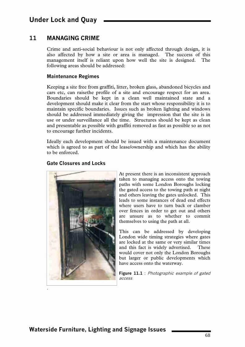
Under Lock and Quay
Waterside Furniture, Lighting and Signage Issues68
11 MANAGING CRIME
Crime and anti-social behaviour is not only affected through design, it isalso affected by how a site or area is managed. The success of thismanagement itself is reliant upon how well the site is designed. Thefollowing areas should be addressed:
Maintenance Regimes
Keeping a site free from graffiti, litter, broken glass, abandoned bicycles andcars etc, can raisethe profile of a site and encourage respect for an area.Boundaries should be kept in a clean well maintained state and adevelopment should make it clear from the start whose responsibility it is tomaintain specific boundaries. Issues such as broken lighting and windowsshould be addressed immediately giving the impression that the site is inuse or under surveillance all the time. Structures should be kept as cleanand presentable as possible with graffiti removed as fast as possible so as notto encourage further incidents.
Ideally each development should be issued with a maintenance documentwhich is agreed to as part of the lease/ownership and which has the abilityto be enforced.
Gate Closures and Locks
At present there is an inconsistent approachtaken to managing access onto the towingpaths with some London Boroughs lockingthe gated access to the towing path at nightand others leaving the gates unlocked. Thisleads to some instances of dead end effectswhere users have to turn back or clamberover fences in order to get out and othersare unsure as to whether to committhemselves to using the path at all.
This can be addressed by developingLondon wide timing strategies where gatesare locked at the same or very similar timesand this fact is widely advertised. Thesewould cover not only the London Boroughsbut larger or public developments whichhave access onto the waterway.
Figure 11.1 : Photographic example of gatedaccess
.

Under Lock and Quay
Waterside Furniture, Lighting and Signage Issues69
The Use of Closed Circuit Television (CCTV)
CCTV is a formal way of managing crime on watersides and is usuallyemployed in extreme circumstances where other less formal levels ofsurveillance are insufficient in deterring or reducing the levels of criminalactivity. A number of factors need to be considered in specifying the use ofCCTV:
� have other more preferable methods of crime prevention been tried andtested at the site?
� is the frequency and severity of crime sufficient to warrant suchmeasures?
� who will fund the cost of, monitor and manage such an operation?
� how can the system be installed without either detracting from thehistoric waterside character or cluttering up the site? Can the cameras beattached to existing buildings (consider the limitation which will beimposed where listed buildings are concerned)
� is CCTV appropriate to the location of the site? eg CCTV is notappropriate in predominantly vegetated or rural locations.
It is important to remember that CCTV should only be used as a toolwithin an integrated security system.
Under Lock and Quay
Community Awareness and Participation70
12 COMMUNITY AWARENESS AND PARTICIPATION
A very powerful and useful tool in tackling crime is the community itself.
Community based projects can take the form of:
� consultation with community groups, residents associations etc. duringthe design stage of the scheme;
� formation of working groups for the implementation of a scheme;
� involvement in community and public art projects;
� recruiting local residents in the maintenance of a scheme eg maintenanceof vegetation, Boat Watch, residential boat groups (CHUG - Canal inHackney User Group);
� Neighbourhood Watch Schemes.
The aim of community involvement is to instil a sense of ownership andpride in a site and hopefully suppress the desire by members of thecommunity to wilfully damage or destroy the waterway environment. Abalance needs to be drawn however, as involving the community can oftenbe a complex and long winded route to designing and implementing ascheme and can frustrate the commercial demands of developers and theirclients.
London's Waterway Partnership employ Community Project Managerswho work with the community and interested groups, act as a local point ofcontact and help to develop initiatives and projects which will create andsustain a safer waterway environment in London.

Under Lock and Quay
Conclusions and Recommendations71
13 CONCLUSIONS AND RECOMMENDATIONS
Crime and anti-social behaviour is an unavoidable feature of our society,however it is one that can to the greater part be controlled. The waterwaysthrough their nature and usage present opportunities for crime to happen,not only to the detriment of the waterway users but also the surroundingland users and the local community in general.
Throughout this document there are examples of good and bad practice inthe treatment of waterside sites both existing and future developments.However, the overriding theme in order to design out crime is the need forearly consultation and the inclusion of design measures at the planningstage as part of an integral approach to new development and improvementschemes, rather than ad hoc measures being implemented once adevelopment has been completed.
Developers and local planning authorities, in consultation with theCPDA’s, ALO’s and British Waterways have a crucial role in ensuring thatpotential to eliminate or reduce crime is maximised while safeguarding andenhancing the historic fabric and visual quality of the waterwayenvironment. It is hoped that this document encourages such practices tothe benefit of all.

Under Lock and Quay
Contacts72
CONTRIBUTORS AND CONTACTS
This document has been jointly produced by British Waterways and the LondonMetropolitan Police.The co-authors of this document are:
Heather Clarke, Planner & Urban Designer (Planning Team Co-ordinator), BW
Chloë Denham, Landscape Architect, British Waterways
In partnership with the Project Steering Group Members:Calvin Beckford - CPDA Metropolitan Police, London Borough of Camden
Mark Hankins - Community Safety Officer, London Borough of Hillingdon
Sharon Williams - CPDA Metropolitan Police, London Borough of Westminster
Ian Gray - CPDA, Metropolitan Police, London Borough of Islington
Chris Stagg MBE - CPDA, Metropolitan Police (retired), London Borough of Brent
Mike Manuel - Environment Manager, British Waterways
Mike Barrett - Chief Safety Engineer, British Waterways
Illustrations by:Jason Belgeonne (freelance)
Kevin Holmes, Urban Designer, British Waterways
British Waterways, the Association of Chief Police Officers, the authors and thecontributors accept no responsibility for loss, damage, or injury that may be causedby any inaccuracies, errors or omissions in this document.
British Waterways London Regional Office
London Waterway OfficeThe Toll HouseDelamere TerraceLittle VeniceLondonW2 6ND
Tel: 020 7432 8309
Fax: 020 7286 7306
London Metropolitan Police
Please contact your Police Headquarters for the details of your Architectural Liaison Officer(ALO) or, in the Metropolitan Police area, Crime Prevention Design Advisor (CPDA) whocan assist you further.
For additional copies of this report please contact:
Waterway Environment ServicesBritish WaterwaysThe Locks, HillmortonRugbyWarwickshire CV21 4PP
Tel: 01788 566000
Fax: 01788 541076
E-mail: [email protected]

Under Lock and Quay
Appendix 1i
SUMMARY OF CURRENT CRIME PREVENTION LITERATUREAND INITIATIVES
Review of Literature
The Police Service as a whole are instrumental in publishing literature andlaunching initiatives and schemes to help combat crime throughout the UK. Theliterature issued is aimed at a wide range of user groups from school children andhomeowners through to planners and architects, and this is reflected in the formatand style of the literature itself.
The documentation published is prescriptive giving positive and practical guidanceon improving safety and security, in some cases with direct reference to waterwayseg:
� Boat Mark - produced in conjunction with the British Marine IndustriesFederation, which gives information regarding marking of boat fixtures andfittings for easy tracing in the event of theft.
� Get Wise - produced by the Police and aimed at children. It gives appropriateaction to be taken in the event of an accident adjacent to water.
Several documents/initiatives are of particular relevance to the issue of reducingcrime through design along the waterways:-
Secured by Design (SBD)
This is a major police initiative that has been running for over 10 years. Theobjective of the scheme is to achieve a good overall standard of security for a varietyof building types and their immediate environment (including design of softlandscaping and lighting schemes) which will help deter criminal and anti socialbehaviour within their curtilage. A minimum standard is therefore set for certainbuilding features eg windows and doors must comply with the relevant BritishStandards for enhanced security. Different standards are applicable to residential,commercial multi-storey buildings and sheltered accommodation.
Some local authorities refer to these guidelines in their development plans and, forcertain buildings insist upon compliance with this initiative.
In anticipation of increased use of these guidelines, it is envisaged that a nationalcentre is to be established to co-ordinate and run these schemes.
The SBD initiative should be read in conjunction with this document, andconsidered in relation to all waterside development.
Further information, including design guidelines can be found on the SBD web site(www.securedbydesign.com).
The Secured Car Parks Award Scheme
This scheme was launched by the Association of Chief Police Officers in 1992, andis sponsored and administered by the Association of British Insurers and theAutomobile Association.
Under Lock and Quay
Appendix 1ii
It gives guidance to car park owners, operators and developers on establishing andmaintaining a safe, secure car park facility.
The document sets out a list of criteria to be met and looks at a number of ways inwhich crime levels can be reduced, for example, through surveillance, lighting,signage, access, layout and management practices.
The owner or operator undertakes a self-assessment against the set criteria which issubsequently reviewed by a police officer and, subject to outcome, an award can beclaimed. The scheme helps focus attention on a facility which is often dangerousbut overlooked.
This document is relevant to car parks located adjacent to waterside areas.
Defensive Planting
Several guides have been produced by the police regarding the role that planting hasto play in deterring crime. Guidance ranges from technical literature for use bydevelopers and local authorities in the design of large scale landscape schemes, toglossy pamphlets regarding effective garden design, aimed at the general public.
The guidance lists species of plants which can be used effectively and also detailsmeasures to prevent planting, turf etc. being stolen from a garden or public area.This information should be considered in relation to waterside planting schemes inassociation with residential, commercial and industrial developments to reduce theoveruse of more traditional crime reduction techniques such as barriers, barbed wireand finials.
Public Conveniences Problem Reduction Guide
This document is published by the Staffordshire Police Crime Reduction andCommunity Safety Unit.
Through the use of case studies, the document highlights problems encounteredwith this type of facility alongside examples of good practice where potentialproblems have been reduced through design measures. It also addresses issues ofdisabled access and gives a self checklist to ensure certain criteria are met.
The Public Conveniences Problem Reduction Guide is particularly applicable tosanitary station design along the waterways and should be cross referenced with theinformation contained in this document.
It should be noted that the above review of literature and initiatives barely scratchesthe surface of documentation, experience and advice available from the CPDA andALO. Local Planning Authorities should encourage potential applicants to makeearly contact and liaise with the Metropolitan Police during pre planningapplication submissions particularly with regard to major waterside developmentschemes.

Under Lock and Quay
Appendix 2iii
BRITISH WATERWAYS GUIDANCE NOTE ON BRIDGE DESIGN
Bridge crossings over London’s waterways, particularly those poorly designed havethe potential to affect both formal and informal waterway recreation as well as thewider leisure and tourism industry.
As a result, British Waterways will only consider a highway or rail bridge overwaterways in the event that no alternative infrastructure improvements are provenfeasible.
Any proposed location for a new bridge should not be determined solely byconsidering the needs of the scheme which has engendered the bridge proposal butalso the effect of the proposed bridge on the waterway corridor. The impact of anybridge on the waterway corridor should include consideration of the following:
� navigational needs;
� environmental, visual and landscape impact on the waterway corridor;
� bridge design and aesthetics; and
� needs of towing path users.
Navigational Needs
A skew bridge would generally be considered unacceptable as it would extend thelength of straight navigation beneath the bridge. Any bridge should beperpendicular, unless it can be proven to there are good reasons not to.
Navigational clearance needs to be established. These will vary from navigation tonavigation and from site to site owing to considerations of craft dimensions, one ortwo way boat workings, horizontal alignment and visibility, proximity to otherstructures, dredging and other maintenance activities. British Waterways stronglyrecommend that the guidance note advises developers to contact British Waterways’London Regional Office (020 7432 8300) at an early stage to define the following:
� Headroom over navigation
� Headroom over towing path
� Navigation width
� Towing path width
� Navigation depth
� Forward visibility for navigators and towing path users.
Any highway bridge crossing will need to clear the navigation in a single span andthe towing path must pass under the same span as the navigation. Piers within thewaterway would be considered unacceptable to British Waterways. Any footbridgedesign must have the ability to convey floodwater without hindrance. Furthermore,any changes to existing bridge parapets must take into account flood defencerequirements.

Under Lock and Quay
Appendix 2iv
Environmental, Visual and Landscape Impact on the Waterway Corridor
The impact of the bridge on the waterway environment will require detailedconsultation with British Waterways. Not only are bridge aesthetics of greatimportance but also the setting of the bridge on the local and wider landscape mustbe considered.
� London’s waterways create linear corridors. Bridges are seen by waterway usersas part of a sequence of structures, most of which are contemporary with theconstruction of the canal. Bridges are viewed at leisure by users whethertravelling on foot at walking pace, from a boat, fishing at close quarters or from adistance.
� British Waterways recognise that an open parapet on a road bridge would allowroad users to view the navigation and have the advantage of a weight saving overmasonry parapet. However, British Waterways are concerned that appropriateattention is paid to screening views of vehicles. This could be achieved byincorporating into the bridge design a decorative parapet detail which acts as avisual screen or distracts the eye away from the vehicles crossing over the bridge.
� With regards to setting, equally important as to how the new structure usuallyconnects to existing features. Junctions that neither meet in the vertical nor thehorizontal plane wherever possible. The wing wall directions should generallybe parallel to the transport mode being carried across the navigation.Consideration needs to be given to surfaces both beneath and above newbridges, respecting the character and scale of the existing environment. Civilengineering works associated with bank piling and protection need to besimilarly integrated with the original canal bank. Adequate land must beallocated to achieve the ramp and supporting bank to run parallel to thenavigation.
� High embankments are inappropriate being visible at great distance and creatingan impact that can be wholly intrusive.
� Planting should be integral with the design of the bridge and should seek notjust to replace removed vegetation but to enhance the total waterway scene.
Bridge Design and Aesthetics
When considering the aesthetics of the bridge there are two main options:
� a striking dramatic contemporary structure may well be appropriate and capableof representing the heritage of the future; or
� a low key design reflecting the scale, style, material, proportions and heritage ofthe waterway as a whole.
In either case British Waterways requires a high quality, well designed and detailedproposal.

Under Lock and Quay
Appendix 2v
The construction of the canal network marked a period of astonishing innovation inengineering and architectural design, using new materials such as cast iron.Therefore, British Waterways believes that opportunity now exists to apply similaringenuity to the design of new bridge structures. Such a philosophy extends beyondthe simple substitution of modern materials for old but requires a fresh approach.However, all design solutions should be derived from a contextual analysis of thesetting, the use and future potential of the waterway for leisure and tourismpurposes and of course an understanding of the hydrological requirements of thewater over which it is passing. It is crucial to build in sympathy with the historiccharacter and fabric of a waterway in order to enhance the waterway environment,ie the appropriate aesthetics for any new bridge crossings over any waterway mustintegrate the new respectfully with the old, reflecting the scale, style, material,proportions and heritage of the waterway as a whole. However, this requirementdoes not preclude new high quality contemporary design solutions nor does it callfor a pastiche of historic road or footbridges.
A cursory look to the past can be very informative in designing for the future. Keyissues relate to scale, mass, form, shape, height, depth of deck, span, symmetry,proportion and solid to void relationship.
Footbridges over water do not need to comply with the technical requirements forroad bridges, and therefore have much more freedom of design.
Developers are strongly advised to contact British Waterways in order to obtain thefullest information on Codes of Practice for works affecting British Waterways.Aspects which will need to be discussed with British Waterways at an early stagewith regard to bridge aesthetics include:
� Scale, style, proportions and massing
� Materials and facings - should generally be in keeping with those foundlocally. There is, however, a presumption towards an appropriate brick or stone,with the facing material and bond pattern reflecting the local vernacular.
� Colour
� Architectural features such as string courses, pilasters, pilaster caps andpatterned brickwork. It is important that the bridge expresses its structural formand that such architectural features are inherent in the design and not “add-onextras”. an arched bridge would be preferred as traditional waterway bridgeshave curvature. Adding fake historical detail would be unacceptable to BritishWaterways on design and safety terms. Therefore, a beam bridge with false archfacades would be considered unacceptable as, i.e. an arch built onto the face of aflat box section bridge can be lethal for a boater who has adjusted to a squareheadroom beneath the dark soffit, suddenly has to duck to avoid an arch onmerging into bright sunlight.

Under Lock and Quay
Appendix 2vi
Needs of Towing Path Users
Safety and security considerations for the towing path users and boaters must beevaluated at the outset of any project, and at every stage of the design processthereafter.
� Any bridge design proposals should provide direct pedestrian access to thetowing path from the bridge. However, it is preferable that there be nopedestrian access to offside abutments of canal bridge in order to preventgraffiti.
� The environmental quality of the underside of any bridge must be attractive andnot intimidating nor oppressive for towing path users and boaters. There shouldbe no ‘dead areas’ prone to vandalism on towing paths under bridges. All canaland river bridges will generally be seen by slow-moving viewers, principally onthe water or along the towing path. The bridge soffit is visually important as it isseen by pedestrians and boat users as they pass underneath. Forms of structurewhich give visual interest on the soffit should therefore be chosen and thequantity and quality of detail are very important. Surface texture and modellingare necessary and natural materials such as stone, brick and timber areparticularly appropriate for river and canal bridges.
� The towing path under the bridge should be surfaced in material consistent withthe character of the waterway.
� British Waterways do not generally encourage bridge designers to incorporateledges and holes suitable as nest/roost sites for birds as these can:
� be used by drug dealers to hide their deals/packets;
� detrimentally affect the environmental quality of the underside of anybridge for towing path users and boaters. Bat boxes can be designed andused where appropriate.
� The noise impact upon the waterway environment resulting from a new roadbridge crossing must be considered. If noise levels are too great mitigationmeasures must be introduced.

Under Lock and Quay
Bibliography
BIBLIOGRAPHY
Secured by Design, Metropolitan Police, Version 3.0 1998
Regent’s Canal, Suggested Crime Prevention Improvements (ForDiscussion), Police
Public Conveniences Problem Reduction Guide, Staffordshire Police CrimeReduction and Community Safety Unit (AL06/98)
Neighbourhood Watch Members Guide, Directorate of Public Affairs andInternal Communication, Police Service, New Scotland Yard, February 1998
Pubwatch, A Briefing for Licensees, Metropolitan Police Service
Keep your Boat Secure, Home Office and Central Office of Information (HMSO11759 HOME J1344RP 2/91)
Keep Your Boat Crimetight, Home Office and Central Office of Information,1977
The Secured Car Park Award Scheme, Guidelines for self assessment,Association of Chief Police Officers in England and Wales in partnership withBritish Parking Association, Automobile Association and Home Office
Haringay Council, Designing Out Crime Symposium, 8th May 1997, AnIntroduction to Crime Prevention Through Environmental Design, BobKnights MBE MSc CPDA
Designing Out Crime, Directorate of Public Affairs and Internal CommunicationMetropolitan Police Service, New Scotland Yard (ref. 43000012 O)
Be safe near water, London’s Police are here to help you!, Thames DivisionSafety Campaign and the Metropolitan Police
Get Wise! Directorate of Public Affairs and Internal Communications,Metropolitan Police Service, New Scotland Yard
Be Water Wise, Thames Water and The Royal Society for the Prevention ofAccidents
Safe Mooring? or Thieves’ Paradise? British Marine Industries Federation
Rosie and Jim: Be like Rosie and Jim and enjoy Britain’s waterways safely,British Waterways and Royal Society for the Prevention of Accidents, June 1995
The Blue Code for water safety, Royal Life Saving Society, RLSS-UK 1984
Extract from Schools Involvement Programme, Protecting OurselvesPhysical Safety, Primary, Metropolitan Police Service

Under Lock and Quay
Bibliography
Grand Union Canal (Regents Arm), Stretch from Muriel Street to YorkWay, Observations and Recommendations to Improve Public Safety,Metropolitan Police Service, October 1997
Kings Cross Marina, Wharfdale Road N1, Observations andRecommendations, Metropolitan Police Service, June 1997
Preventative Policing Skills, Home Office Crime Prevention Centre, June 1991
Designing for Security on the National Cycle Network, Sustrans, InformationSheet FF21, November 1998
Explore London’s Canals, British Waterways and London Tourist Board andConvention Bureau
Our Plan for the Future 1999-2003, British Waterways, July 1998
The Waterway Environment and Development Plans, British Waterways
Waterway Design Manual, Volume One, Buildings and Facilities, BritishWaterways, 1999
Waterway Design Manual, Volume Two, Repair and Conservation, BritishWaterways, 1999
Waterway Design Manual, Volume Three, Landscape, British Waterways,1999
Waterside Design and Planning Handbook, British Waterways, 1998
Defensible Space, People and Design in the Violent City, Oscar NewmanJanuary 1972
Vandalism, Edited by Colin Ward, 1973
Canalside Development in Birmingham, Design Guidelines ConsultationCopy, Birmingham City Council Planning and Architecture
Aide Memoire for Effective CCTV Systems, London Police Forces forOperation Guardian Terrorist Prevention Group
Burglars Don’t Seem to Understand Defensible Space, Bill Hillier and SimonShu
ILE Report: Security Lighting (Extract Chapters 34, 5, 6, 7, 8, 9, 10), 1997
Fear of Crime, Zenda 1994Territoriality and Defensible Space, Oscar Newman 1972


����Waterway Environment Services