uct winter report - conway school - final
TRANSCRIPT
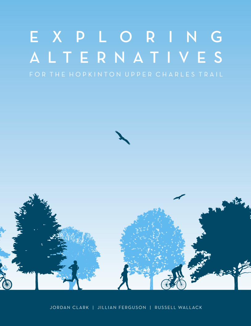
E X P L O R I N GA L T E R N A T I V E SF O R T H E H O P K I N T O N U P P E R C H A R L E S T R A I L
J O R DA N C L A R K | J I L L I A N F E R G U S O N | R U S S E L L WA L L AC K
SPECIAL THANKS TO THE UPPER CHARLES TRAIL COMMITTEE:
Kenneth Parker, Chair
Jeffrey Barnes
John Coutinho
Jane Moran
Dave O’Brien
Mike Resteghini
Barry Rosenbloom
Bob Snyder
Eric Sonnett
Gary Trendel
Copyright © 2015 The Conway School
E X P L O R I N GA L T E R N A T I V E SF O R T H E H O P K I N T O N U P P E R C H A R L E S T R A I L
Prepared for the Upper Charles Trail CommitteeHopkinton, Massachusetts
Jordan Clark, Jillian Ferguson, and Russell Wallack The Conway School
Winter 2015

Executive Summary
The Upper Charles Trail is a joint privately/publicly funded project to convert a 27-mile abandoned railbed across five communities into a scenic recreational trail for bicycling, walking, cross-country skiing, roller-blad-ing, and other non-motorized uses. The 1993 Holliston Open Space and Recreation Plan originally proposed a trail network that would repurpose a former railroad passing through the towns of Sherborn, Holliston, Milford, Hopkinton, and Ashland. Currently, the Milford segment of the rail trail is complete, and the Holliston portion is in progress.
The Town of Hopkinton has charged its Upper Charles Trail Committee (UCTC) with developing the town’s portion of the trail to meet the demands of rapid resi-dential growth and provide a more environmentally sen-sitive transportation alternative. The UCTC hired a team from the Conway School to inventory the physical and environmental conditions along the railbed, and provide recommendations for multi-use trail routes while high-lighting the opportunities that each trail provides to Hopkinton and the broader Upper Charles network.
CHALLENGES & OPPORTUNITIES
Hopkinton sits at the intersection of Interstates 90 and 495. Approximately thirty miles west of Boston, the town—known regionally as the starting line of the Boston Marathon—is valued by its residents for its sce-nic, rural qualities. The convenient location for commut-ers has played a role in doubling Hopkinton’s population in the past thirty-five years and making the town a bed-room community. The greenfield construction that has accompanied this type of sprawling growth has dimin-ished the amount of green space in parts of Hopkinton. Ongoing and future developments such as Legacy Farms, Hopkinton Mews, and the proposed Crossroads Redevelopment will likely continue to drive population growth and increase commercial opportunities in Hopkinton, so the town is looking to preserve its valued open space where possible. A trail that connects many of these open spaces can provide community residents with easy access to their natural surroundings and can func-tion as necessary wildlife corridors.
One challenge within a fast-growing town like Hopkinton is that long-time residents may fear the town losing its identity. As new residents come from outside
communities they bring their own expectations for what the town should be. A multi-use trail would help encourage Hopkinton residents to connect socially with each other. By bringing residents into a shared space for recreation and transportation, the trail would encourage social interactions.
In neighboring Holliston, the trail planners were able to develop the whole trail along the former CSX railroad. Hopkinton’s segment of the rail line was built in 1863 and fully removed by 1950; it ran approximately six miles, along Hayden Rowe Street north from the Milford town line, and then continued on the north side of Main Street to connect to Ashland. In Hopkinton, only some of the physical legacy of the railbed still remains. Ownership of the railbed is fragmented by over thirty different property owners, most of whom are pri-vate residential landowners.
In addition to the challenges that private ownership of the railbed presents, a successful multi-use trail in Hopkinton must navigate a variety of physical and envi-ronmental challenges. Sections of the railbed pass near wetlands or through wetland buffer zones. The railbed crosses West Main Street at Hopkinton Lumber, Route 85 north of downtown, and East Main Street near Wilson Street. All three of these crossings experience high volume, fast-moving traffic. Historically, the rail-road’s East Main Street crossing was below grade through a tunnel. The tunnel was filled in many years ago though, and its use would require significant excavation.
The challenging conditions around the railbed provide impediments to developing the Upper Charles Trail in Hopkinton, but the town’s physical conditions could also create scenic opportunities along the trail network. The wetlands and forests provide attractions for bird-watch-ers, and educational opportunities for nearby schools. Rocky outcrops make for entertaining rock climbing and mountain biking. These features can serve to attract regional trail users. On its busier days, the Milford por-tion of the Upper Charles Trail sees close to 3,000 users, many of whom are Hopkinton residents. When Hopkinton and eventually Ashland connect into the trail network, this usership will likely increase.
In the 2013 Open Space and Recreation Plan, only 8 percent of survey respondents felt that Hopkinton had
sufficient recreation space. Those same survey respon-dents listed bicycle trails and walking/running trails as the two most important recreation spaces for Hopkinton to develop. While Hopkinton has inviting open spaces and numerous sports fields, they are largely not con-nected by a walkable network, so residents tend to use cars to access them from their homes. Not only can trails provide an opportunity for passive recreation, but they increase the value of existing recreational spaces by con-necting them and making them more widely accessible.
A multi-use trail offers Hopkinton the opportunity to invest in its future. The regional network of trails con-nects not only to the immediate surrounding towns, but could also eventually connect into the Boston metropoli-tan area, and even statewide corridors like the Mass Central Rail Trail that has been proposed as a connec-tion from Boston to Northampton to the west.
RECOMMENDATIONS
Rather than thinking of the Hopkinton Upper Charles Trail as restricted to the railbed corridor, the UCTC should work with the people of Hopkinton to plan for a complete trail network. This network will provide the benefit of connecting Hopkinton’s residents with the open spaces around them, the town’s schools, gathering places, new landmarks like the proposed Marathon Museum, and densely populated areas like Legacy Farms. Additionally, a trail that does not use the railbed in some areas can avoid privately owned parcels where necessary, and take advantage of parcels that are already owned by the Town of Hopkinton or organizations that are friendly to the trail. Even if some private owners of portions of the railbed are in favor of granting access to the multi-use trail, just one opponent could block the trail’s development for years.
Trail planning will likely be a multi-year, multi-phase project. It is unlikely that the whole trail will be approved, funded, and constructed in one phase, so the UCTC should work with town officials and the public to construct the portions that can connect to the existing Center Trail with the fewest barriers. Establishing a vision for the trail’s eventual route, and taking initial (low-cost) steps to allow the trail to take shape, can be instrumental in generating enthusiasm and momentum for the trail as a whole. Constructing the most readily
available (ownership-wise) and highest-priority seg-ments can also serve these purposes. This report recom-mends dividing the trail planning into four portions based on the respective challenges and opportunities in each segment. These four segments are labeled A-D in the latter portion of the report, and are discussed in detail beginning on page 36.
The planning process should be an open and collabora-tive process. The UCTC has already met with developers and municipal stakeholders to talk about the potential benefits of a trail and general community concerns. To be fully successful, however, the trail planning and design process needs to involve input from the broader commu-nity. The next phases of the planning process should use this document to communicate options for the Hopkinton Upper Charles Trail. This engagement can take many forms. Distributing this document electroni-cally will allow residents to familiarize themselves with the planning process, while in-person meetings or tabling at public events can be opportunities for produc-tive and thoughtful communication.
Increased connectivity between dense residential areas, the historic downtown, and Hopkinton’s open spaces can move the town toward its longstanding goal of down-town revitalization. A trail that connects all of these des-tinations not only improves the accessibility of recreational spaces for children, the physically chal-lenged, and the elderly, but also encourages residents to get out of their cars and interact with their neighbors.
CONTENTS
The Upper Charles Trail
Hopkinton’s Recent Developments
Trails
Regional Trails
Local Trails
Walkability
Criteria for Development
Addressing Trail Concerns
Rail-Trails and Property Values
Existing Conditions
Road Crossings
Property Ownership
Topography and Geology
Vegetation and Wildlife
Trail Planning Options
Trail Type Options
Continuing the Upper Charles Trail
Milford to Granite Street
Granite Street to Center Trail
Center Trail to Legacy Farms
Legacy Farms to Ashland
What’s Next?
References
Appendix A: Stakeholder involvement
Appendix B: Parking Study
Appendix C: Possible Sources of Funding
Appendix D: Transmission Line ROWs
1
2
5-11
6
7
8
9
10
11
12-21
12
14
16
18
22-45
22
24
26
28
36
44
46
47
48
49
50
51
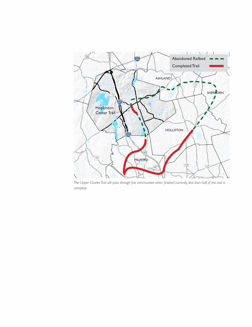
Abandoned Railbed
Completed Trail
Hopkinton Center Trail
ASHLAND
HOLLISTON
MILFORD
SHERBORN
The Upper Charles Trail will pass through five communities when finished; currently, less than half of the trail is
complete.
1EXPLORING OPPORTUNITIES FOR THE HOPKINTON UPPER CHARLES TRAIL
The Upper Charles Trail
HISTORY OF THE UPPER CHARLES TRAIL
A 1997 feasibility study conducted by the Metropolitan Area Planning Council (MAPC) assessed the feasibility of the Upper Charles Trail. Following the MAPC’s finding that such a trail was feasible, the communities of Ashland, Sherborn, Holliston, Milford, and Hopkinton began to plan and develop a multi-use trail to bring their communities together. As conceived, the Upper Charles Trail (UCT) would convert an abandoned rail corridor (forming a twenty-plus-mile loop) into a scenic recreational path for bicycling, walking, cross-country skiing, roller-blading, and other non-motorized uses. Milford completed its portion of the trail in 2014, and the Holliston trail currently stretches from its downtown to the Milford line.
The finished portions of the trail are the result of lengthy and complex planning and implementation processes, requiring coordination between trail planners, local, regional and state authorities, and community members. The 1997 feasibility study came four years after the Holliston Open Space and Recreation Plan (OSRP) first presented the concept for the regional trail, and though the planning and organizing began in earnest that same year, it would be ten years before the first (three-mile) phase of Milford’s trail was open for use.
Today, roughly twelve miles of the UCT is completed and sees frequent use. The most recent traffic count, conducted in Milford in May of 2012, showed more than 2,800 users over the course of a typical Saturday, exceeding the feasibility study’s projections for the total
trail. A significant number of the trail’s users come from surrounding communities; on the survey portion of Hopkinton’s 2013 OSRP, 43 percent of respondents said they regularly travel south to use Milford’s trail. In both Holliston and Milford, the trail has become a focal point for community events.
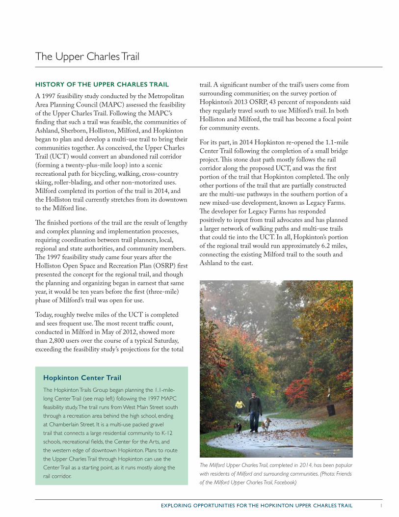
For its part, in 2014 Hopkinton re-opened the 1.1-mile Center Trail following the completion of a small bridge project. This stone dust path mostly follows the rail corridor along the proposed UCT, and was the first portion of the trail that Hopkinton completed. The only other portions of the trail that are partially constructed are the multi-use pathways in the southern portion of a new mixed-use development, known as Legacy Farms. The developer for Legacy Farms has responded positively to input from trail advocates and has planned a larger network of walking paths and multi-use trails that could tie into the UCT. In all, Hopkinton’s portion of the regional trail would run approximately 6.2 miles, connecting the existing Milford trail to the south and Ashland to the east.
Hopkinton Center Trail
The Hopkinton Trails Group began planning the 1.1-mile-long Center Trail (see map left) following the 1997 MAPC feasibility study. The trail runs from West Main Street south through a recreation area behind the high school, ending at Chamberlain Street. It is a multi-use packed gravel trail that connects a large residential community to K-12 schools, recreational fields, the Center for the Arts, and the western edge of downtown Hopkinton. Plans to route the Upper Charles Trail through Hopkinton can use the Center Trail as a starting point, as it runs mostly along the rail corridor.
The Milford Upper Charles Trail, completed in 2014, has been popular
with residents of Milford and surrounding communities. (Photo: Friends
of the Milford Upper Charles Trail, Facebook)
2 EXPLORING OPPORTUNITIES FOR THE HOPKINTON UPPER CHARLES TRAIL
Hopkinton’s Recent Developments
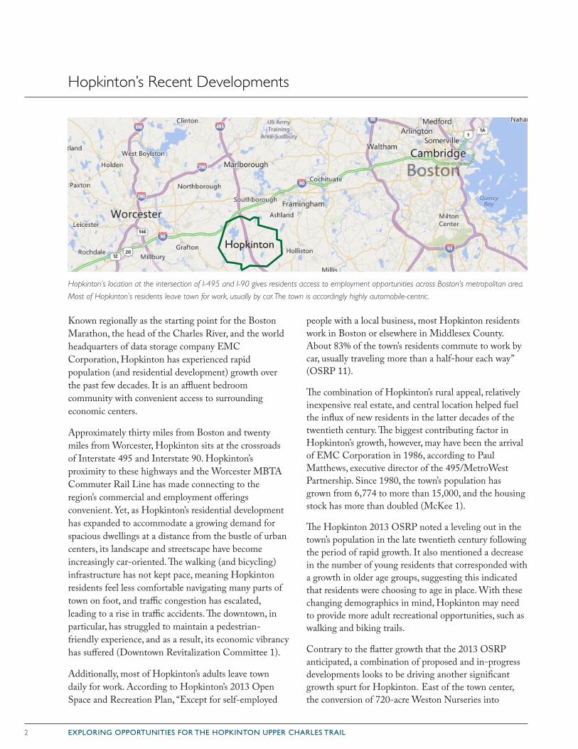
Known regionally as the starting point for the Boston Marathon, the head of the Charles River, and the world headquarters of data storage company EMC Corporation, Hopkinton has experienced rapid population (and residential development) growth over the past few decades. It is an affluent bedroom community with convenient access to surrounding economic centers.
Approximately thirty miles from Boston and twenty miles from Worcester, Hopkinton sits at the crossroads of Interstate 495 and Interstate 90. Hopkinton’s proximity to these highways and the Worcester MBTA Commuter Rail Line has made connecting to the region’s commercial and employment offerings convenient. Yet, as Hopkinton’s residential development has expanded to accommodate a growing demand for spacious dwellings at a distance from the bustle of urban centers, its landscape and streetscape have become increasingly car-oriented. The walking (and bicycling) infrastructure has not kept pace, meaning Hopkinton residents feel less comfortable navigating many parts of town on foot, and traffic congestion has escalated, leading to a rise in traffic accidents. The downtown, in particular, has struggled to maintain a pedestrian-friendly experience, and as a result, its economic vibrancy has suffered (Downtown Revitalization Committee 1).
Additionally, most of Hopkinton’s adults leave town daily for work. According to Hopkinton’s 2013 Open Space and Recreation Plan, “Except for self-employed
people with a local business, most Hopkinton residents work in Boston or elsewhere in Middlesex County. About 83% of the town’s residents commute to work by car, usually traveling more than a half-hour each way” (OSRP 11).
The combination of Hopkinton’s rural appeal, relatively inexpensive real estate, and central location helped fuel the influx of new residents in the latter decades of the twentieth century. The biggest contributing factor in Hopkinton’s growth, however, may have been the arrival of EMC Corporation in 1986, according to Paul Matthews, executive director of the 495/MetroWest Partnership. Since 1980, the town’s population has grown from 6,774 to more than 15,000, and the housing stock has more than doubled (McKee 1).
The Hopkinton 2013 OSRP noted a leveling out in the town’s population in the late twentieth century following the period of rapid growth. It also mentioned a decrease in the number of young residents that corresponded with a growth in older age groups, suggesting this indicated that residents were choosing to age in place. With these changing demographics in mind, Hopkinton may need to provide more adult recreational opportunities, such as walking and biking trails.
Contrary to the flatter growth that the 2013 OSRP anticipated, a combination of proposed and in-progress developments looks to be driving another significant growth spurt for Hopkinton. East of the town center, the conversion of 720-acre Weston Nurseries into
Hopkinton
Hopkinton’s location at the intersection of I-495 and I-90 gives residents access to employment opportunities across Boston’s metropolitan area.
Most of Hopkinton’s residents leave town for work, usually by car. The town is accordingly highly automobile-centric.
3EXPLORING OPPORTUNITIES FOR THE HOPKINTON UPPER CHARLES TRAIL
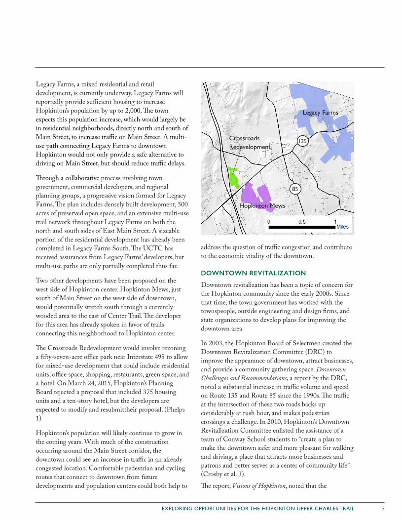
Legacy Farms, a mixed residential and retail development, is currently underway. Legacy Farms will reportedly provide sufficient housing to increase Hopkinton’s population by up to 2,000. The town expects this population increase, which would largely be in residential neighborhoods, directly north and south of Main Street, to increase traffic on Main Street. A multi-use path connecting Legacy Farms to downtown Hopkinton would not only provide a safe alternative to driving on Main Street, but should reduce traffic delays.
Through a collaborative process involving town government, commercial developers, and regional planning groups, a progressive vision formed for Legacy Farms. The plan includes densely built development, 500 acres of preserved open space, and an extensive multi-use trail network throughout Legacy Farms on both the north and south sides of East Main Street. A sizeable portion of the residential development has already been completed in Legacy Farms South. The UCTC has received assurances from Legacy Farms’ developers, but multi-use paths are only partially completed thus far.
Two other developments have been proposed on the west side of Hopkinton center. Hopkinton Mews, just south of Main Street on the west side of downtown, would potentially stretch south through a currently wooded area to the east of Center Trail. The developer for this area has already spoken in favor of trails connecting this neighborhood to Hopkinton center.
The Crossroads Redevelopment would involve rezoning a fifty-seven-acre office park near Interstate 495 to allow for mixed-use development that could include residential units, office space, shopping, restaurants, green space, and a hotel. On March 24, 2015, Hopkinton’s Planning Board rejected a proposal that included 375 housing units and a ten-story hotel, but the developers are expected to modify and resubmittheir proposal. (Phelps 1)
Hopkinton’s population will likely continue to grow in the coming years. With much of the construction occurring around the Main Street corridor, the downtown could see an increase in traffic in an already congested location. Comfortable pedestrian and cycling routes that connect to downtown from future developments and population centers could both help to
address the question of traffic congestion and contribute to the economic vitality of the downtown.
DOWNTOWN REVITALIZATION
Downtown revitalization has been a topic of concern for the Hopkinton community since the early 2000s. Since that time, the town government has worked with the townspeople, outside engineering and design firms, and state organizations to develop plans for improving the downtown area.
In 2003, the Hopkinton Board of Selectmen created the Downtown Revitalization Committee (DRC) to improve the appearance of downtown, attract businesses, and provide a community gathering space. Downtown Challenges and Recommendations, a report by the DRC, noted a substantial increase in traffic volume and speed on Route 135 and Route 85 since the 1990s. The traffic at the intersection of these two roads backs up considerably at rush hour, and makes pedestrian crossings a challenge. In 2010, Hopkinton’s Downtown Revitalization Committee enlisted the assistance of a team of Conway School students to “create a plan to make the downtown safer and more pleasant for walking and driving, a place that attracts more businesses and patrons and better serves as a center of community life” (Crosby et al. 3).
The report, Visions of Hopkinton, noted that the
85
135
Legacy Farms
Hopkinton Mews
Crossroads Redevelopment
4 EXPLORING OPPORTUNITIES FOR THE HOPKINTON UPPER CHARLES TRAIL
car-dominant streetscape and inadequate sidewalk infrastructure discouraged walking around the town center, and that the downtown’s strengths, its historically significant architecture and expansive views, could attract more activity with the right infrastructural changes.
To accomplish these goals, the study suggested the town needed to take measures to “calm speeding and improve the pedestrian experience such as installing medians, narrowing the road, buffering walkways from traffic, shortening and raising pedestrian street crossings, and offering consolidated municipal parking.” And that the town could “enhance the aesthetics and unify the charac-ter of downtown, like signs,trees and seasonal plantings, interesting walkways, streetscape ornaments, and defin-ing gateways.”
Following Visions of Hopkinton, in 2011 the town hired BETA Engineering to create a 25 percent design plan for Main Street reconstruction. The town presented this plan for public feedback, and then included the plan in an application to the Massachusetts Department of Transportation for state funding.
With the assistance of BETA, the Department of Public Works is preparing to resubmit the design plan for a sec-ond round of state review. This resubmission includes five-foot-wide bike lanes for most of Main Street, increased vegetation downtown, and shorter crosswalks for pedestrian safety. These first steps will help to ensure Hopkinton’s multi-modal future.
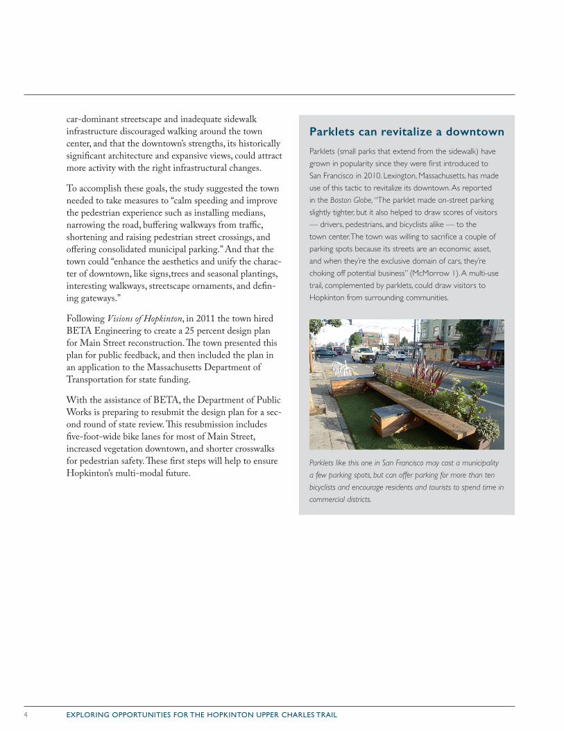
Parklets can revitalize a downtown
Parklets (small parks that extend from the sidewalk) have grown in popularity since they were first introduced to San Francisco in 2010. Lexington, Massachusetts, has made use of this tactic to revitalize its downtown. As reported in the Boston Globe, “The parklet made on-street parking slightly tighter, but it also helped to draw scores of visitors — drivers, pedestrians, and bicyclists alike — to the town center. The town was willing to sacrifice a couple of parking spots because its streets are an economic asset, and when they’re the exclusive domain of cars, they’re choking off potential business” (McMorrow 1). A multi-use trail, complemented by parklets, could draw visitors to Hopkinton from surrounding communities.
Parklets like this one in San Francisco may cost a municipality
a few parking spots, but can offer parking for more than ten
bicyclists and encourage residents and tourists to spend time in
commercial districts.
5EXPLORING OPPORTUNITIES FOR THE HOPKINTON UPPER CHARLES TRAIL
Trails
On January 20, 2015, the Hopkinton Visioning Steering Group presented, to the Hopkinton Board of Selectmen, a vision statement describing Hopkinton in 2025, devel-oped from public survey responses:
“Hopkinton is a vibrant welcoming community centrally located in New England and nestled 26.2 miles west of Boston. We are endowed with open space, natural resources, facilities and programs that promote a well educated and healthy community. We are respectful of our past, engaged in our present, and actively preparing for our future.” (Town of Hopkinton)
A fully developed multi-use trail network in Hopkinton can help achieve this vision by connecting residents to natural spaces and to the social and economic opportu-nities within the town. According to the 2013 OSRP, 4,441 acres of Hopkinton’s total 17,600 acres is pro-tected open space (OSRP 5, 37). Without a comprehen-sive trail network, this space is only accessible by car.
Not all residents have access to open space from their own property. A trail network that creates publicly accessible links between Hopkinton’s extensive preserved open space would increase opportunities for residents to experience natural settings without getting in their car. A successful trail network:
• can increase residents’ time spent in nature. This can promote further environmental awareness, and teach residents the value of preserving open space.
• can improve stress recovery and reduce mental fatigue, by connecting users to nature (Reynolds 4). In towns like Hopkinton where more than 80 percent of the working population commutes to other towns (OSRP 11), a trail network, through open space, that connects to the commuter rail stations in neighboring towns would help residents to capitalize on this benefit.
• creates healthy recreation opportunities by providing people of all ages with attractive, safe, accessible and low- or no-cost places to bird-watch, cycle, walk, hike, jog, or skate.
Trails do not just connect people to open space though. Whether it is the main spine of the UCT or a spur off of it, Hopkinton’s multi-use trails can also provide valuable economic and social connections between residential communities and downtown businesses or cultural desti-nations. These connections can:
• reduce congestion on roadways, and related air and noise pollution.
• allow people of all ages to incorporate exercise into their daily routines by connecting them with places they want or need to go, such as recreation fields, schools, convenience stores, and workplaces.
• create opportunities for trail-side businesses such as restaurants (especially with outdoor seating), bicycle rentals and shops, and lodging for tourism (see below).
• provide a recruitment tool for employers who want to attract healthy and active employees.
Trails can provide significant stimulus to business districts
• A 1993 Massachusetts DEP survey of businesses on the Cape Cod Rail Trail found that 24 percent of the business owners credited the trail as “one reason they opened or acquired their business” (Rails to Trails 4).
• In the same survey, “53% said revenue from trail users made up more than 10% of their business” (Greenways and Trails 4).
• “Marthasville, a small, quiet town in Missouri, has taken on new life since the Katy Hiking and Biking Trail was completed. More than a dozen new businesses have opened and renewed civic pride has led to numerous beautification projects. A user survey of the western half of the Katy Trail showed it generated an estimated $3 million annually in local revenue” (Greenways and Trails, 4).
6 EXPLORING OPPORTUNITIES FOR THE HOPKINTON UPPER CHARLES TRAIL
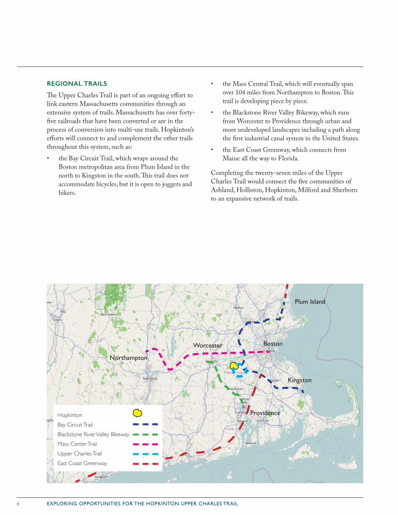
REGIONAL TRAILS
The Upper Charles Trail is part of an ongoing effort to link eastern Massachusetts communities through an extensive system of trails. Massachusetts has over forty-five railroads that have been converted or are in the process of conversion into multi-use trails. Hopkinton’s efforts will connect to and complement the other trails throughout this system, such as:
• the Bay Circuit Trail, which wraps around the Boston metropolitan area from Plum Island in the north to Kingston in the south. This trail does not accommodate bicycles, but it is open to joggers and hikers.
• the Mass Central Trail, which will eventually span over 104 miles from Northampton to Boston. This trail is developing piece by piece.
• the Blackstone River Valley Bikeway, which runs from Worcester to Providence through urban and more undeveloped landscapes including a path along the first industrial canal system in the United States.
• the East Coast Greenway, which connects from Maine all the way to Florida.
Completing the twenty-seven miles of the Upper Charles Trail would connect the five communities of Ashland, Holliston, Hopkinton, Milford and Sherborn to an expansive network of trails.
Northampton
Boston
Kingston
Plum Island
Providence
Worcester
HopkintonBay Circuit TrailBlackstone River Valley BikewayMass Center TrailUpper Charles TrailEast Coast Greenway
7EXPLORING OPPORTUNITIES FOR THE HOPKINTON UPPER CHARLES TRAIL
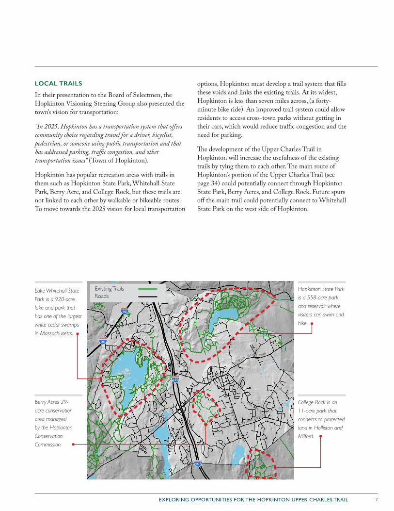
LOCAL TRAILS
In their presentation to the Board of Selectmen, the Hopkinton Visioning Steering Group also presented the town’s vision for transportation:
“In 2025, Hopkinton has a transportation system that offers community choice regarding travel for a driver, bicyclist, pedestrian, or someone using public transportation and that has addressed parking, traffic congestion, and other transportation issues” (Town of Hopkinton).
Hopkinton has popular recreation areas with trails in them such as Hopkinton State Park, Whitehall State Park, Berry Acre, and College Rock, but these trails are not linked to each other by walkable or bikeable routes. To move towards the 2025 vision for local transportation
options, Hopkinton must develop a trail system that fills these voids and links the existing trails. At its widest, Hopkinton is less than seven miles across, (a forty-minute bike ride). An improved trail system could allow residents to access cross-town parks without getting in their cars, which would reduce traffic congestion and the need for parking.
The development of the Upper Charles Trail in Hopkinton will increase the usefulness of the existing trails by tying them to each other. The main route of Hopkinton’s portion of the Upper Charles Trail (see page 34) could potentially connect through Hopkinton State Park, Berry Acres, and College Rock. Future spurs off the main trail could potentially connect to Whitehall State Park on the west side of Hopkinton.
Berry Acres 29-
acre conservation
area managed
by the Hopkinton
Conservation
Commission.
Existing Trails Roads
Hopkinton State Park
is a 558-acre park
and reservoir where
visitors can swim and
hike.
College Rock is an
11-acre park that
connects to protected
land in Holliston and
Milford.
Lake Whitehall State
Park is a 920-acre
lake and park that
has one of the largest
white cedar swamps
in Massachusetts.
8 EXPLORING OPPORTUNITIES FOR THE HOPKINTON UPPER CHARLES TRAIL
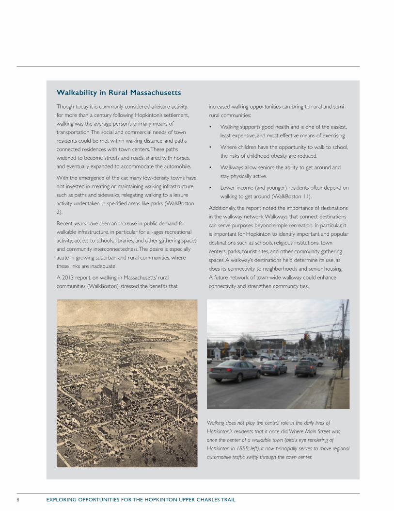
Though today it is commonly considered a leisure activity, for more than a century following Hopkinton’s settlement, walking was the average person’s primary means of transportation. The social and commercial needs of town residents could be met within walking distance, and paths connected residences with town centers. These paths widened to become streets and roads, shared with horses, and eventually expanded to accommodate the automobile.
With the emergence of the car, many low-density towns have not invested in creating or maintaining walking infrastructure such as paths and sidewalks, relegating walking to a leisure activity undertaken in specified areas like parks (WalkBoston 2).
Recent years have seen an increase in public demand for walkable infrastructure, in particular for all-ages recreational activity; access to schools, libraries, and other gathering spaces; and community interconnectedness. The desire is especially acute in growing suburban and rural communities, where these links are inadequate.
A 2013 report, on walking in Massachusetts’ rural communities (WalkBoston) stressed the benefits that
increased walking opportunities can bring to rural and semi-rural communities:
• Walking supports good health and is one of the easiest, least expensive, and most effective means of exercising.
• Where children have the opportunity to walk to school, the risks of childhood obesity are reduced.
• Walkways allow seniors the ability to get around and stay physically active.
• Lower income (and younger) residents often depend on walking to get around (WalkBoston 11).
Additionally, the report noted the importance of destinations in the walkway network. Walkways that connect destinations can serve purposes beyond simple recreation. In particular, it is important for Hopkinton to identify important and popular destinations such as schools, religious institutions, town centers, parks, tourist sites, and other community gathering spaces. A walkway’s destinations help determine its use, as does its connectivity to neighborhoods and senior housing. A future network of town-wide walkway could enhance connectivity and strengthen community ties.
Walking does not play the central role in the daily lives of
Hopkinton’s residents that it once did. Where Main Street was
once the center of a walkable town (bird’s eye rendering of
Hopkinton in 1888; left), it now principally serves to move regional
automobile traffic swifty through the town center.
Walkability in Rural Massachusetts
9EXPLORING OPPORTUNITIES FOR THE HOPKINTON UPPER CHARLES TRAIL
CRITERIA FOR TRAIL DEVELOPMENT
In order to secure state or federal funding, new trails and those undergoing rehabilitation must be in compliance with the 2010 Americans with Disabilities Act (ADA) Standards for Accessible Design, which determine appropriate trail development standards (railstotrails.org).
The following standards, based on the Federal Highway Administration’s Designing Sidewalks and Trails for Access, must be met by a trail network in Hopkinton.
WIDTH
The cleared travel surface (known as the tread) of a shared-use path should be at least ten feet wide. A mini-mum of eight feet may be used on shared-use paths that will have limited use. Shared-use paths are physically separated from motorized vehicular traffic by an open space or barrier, either within a highway right-of-way or within an independent right-of way, and usable for transportation purposes. “Shared-use paths should also have graded areas at least two feet on either side of the path. On shared-use paths with heavy volumes of users, tread width should be increased to a range from twelve to fourteen feet” (FHWA 14-13). The intended uses for a trail also dictate the necessary width. For example, a bike path running parallel to a sidewalk only requires eight feet, but a multi-use path should be ten feet at a minimum.
SLOPE
Universal accessibility standards require trails to meet these guidelines:
• Must not exceed a maximum longitudinal slope of 5 percent without use of a handrail.
• Sections of a trail or access ramps that have longitudinal slopes of between 5 percent to 8.3 percent should have accompanying railings.
• “Railings on shared-use paths should be at least forty-two inches high to prevent bicycle riders from flipping over the top. Avoid protrusions at handlebar height” (FHWA 14-15).
• Wheelchair accessibility and drainage needs require
the cross slope of a trail to not exceed 2 percent slope.
• “Ramps and landings with drop-offs shall have curbs, walls, railings, or projecting surfaces that prevent people from slipping off the ramp. Curbs shall be a minimum of two inches” (US Accessibility Board 4.8.7).
VERTICAL CLEARANCE
“Specifications for vertical clearance vary depending on the designated trail users [...]. Trails that permit eques-trians typically specify a vertical clearance of ten feet, while trails that permit only hikers typically require a vertical clearance of 80 inches [...]. The height of the average blanket of snow added each winter should also be taken into account for trails that allow cross-country skiing and snow machining” (FHWA 82). For example, in the first two months of 2015, Hopkinton received over 100 inches of snow. The snow pack at points this winter was nearly three feet high, so the trail manage-ment must anticipate these conditions.
SURFACE MATERIALS
Packed gravel, such as the material that the Hopkinton Trails Group used for the Center Trail, is ADA compli-ant. This material does prevent roller bladers from using the trail, however, and generally discourages bicyclists from moving at full speed.
Trail planners prefer to use asphalt and concrete for trails that are on steeper slopes. These two materials tend to last longer as they are not as easily eroded. Bicyclists and roller bladers prefer asphalt or concrete for their smoothness.
All three of these material options meet the criteria for ADA compliance, so designers must consider what spe-cific sections of the trail require.
Future design teams may propose trail spurs that offer specific opportunities such as equestrian or hiking trails, and these do not necessarily have to meet the ADA compliance standards. The trail options in this document propose routes that should meet the criteria for all users, but this must be tested on the ground in the trail design process.
10 EXPLORING OPPORTUNITIES FOR THE HOPKINTON UPPER CHARLES TRAIL
“With regard to the trail, it is my observation that the concerns and predictions for police related issues did not materialize in the many years that Milford has had the trail.”
Milford Police ChiefThomas O’Loughlin
ADDRESSING TRAIL CONCERNS
In addition to construction criteria, a successful trail plan must address the community’s and individual residents’ concerns. Trail planners often encounter homeowner concerns about trail routes that run near their property. The most common of these concerns are that trails invite crime, pose liability risks, and lower property values. Some owners worry about a public route that brings “undesirable” outsiders near their prop-erty. While these may be sincere con-cerns, many of them seem to derive from a fear of the unknown and tend to go unrealized after the trail is completed (Flink et al 39).
Studies in various parts of the United States indicate that concerns about trails lowering property values and increasing crime are unfounded. Well designed trails have been shown to increase (or have no effect on) property values, to have no measurable effect on public safety, and to have an overwhelming positive influence on the quality of life for trail neighbors as well as the larger community.
The UCTC can address these community concerns by advocating for effective maintenance measures. For example, trail maintenance organizations should:
• manage overgrown vegetation and tall shrubs along the trail to maintain long sight lines for users;
• place security lighting at trailheads and in parking lots to improve trail safety;
• provide emergency phones or call boxes, and emergency vehicle access;
• keep all trail corridors clean and well maintained to increase the feeling of community ownership of the trail and reduce minor crime such as litter, graffiti and vandalism;
• prohibit the use of motorized vehicles on the trail.
In other towns in Massachusetts, police departments have committed officers to patrolling multi-use paths to ensure a safe space. Northampton has sufficient staffing
for officers to patrol by bicycle, but Easthampton has a smaller staff so they have a motorized rough-terrain vehicle that allows the patrol to move faster both on and off the trail.
Trail patrols can range from informal monthly cleanup and maintenance crews to daily patrols who provide maps, information, and emergency assistance. The primary function of these patrols is to educate trail users
and provide assistance when necessary. They should also be equipped to alert emergency services quickly if needed. The presence of any patrol deters crime and improves users’ enjoyment of the trail.
Compared to the abandoned and forgotten corridors they recycle and replace, trails have a positive influence on community development. By encouraging activities such as walking, running, bicycling and in-line-skating, rail-trails bring communities together and reintroduce neighbors to one another. The way to minimize crime on trails is to ensure that users exercise proper safety pre-cautions, keep the trail well maintained, and boost trail use.
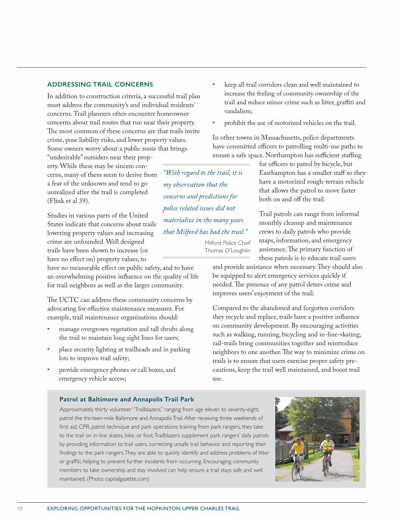
Patrol at Baltimore and Annapolis Trail Park
Approximately thirty volunteer “Trailblazers,” ranging from age eleven to seventy-eight, patrol the thirteen-mile Baltimore and Annapolis Trail. After receiving three weekends of first aid, CPR, patrol technique and park operations training from park rangers, they take to the trail on in-line skates, bike, or foot. Trailblazers supplement park rangers’ daily patrols by providing information to trail users, correcting unsafe trail behavior and reporting their findings to the park rangers. They are able to quickly identify and address problems of litter or graffiti, helping to prevent further incidents from occurring. Encouraging community members to take ownership and stay involved can help ensure a trail stays safe and well maintained. (Photo: capitalgazette.com)
11EXPLORING OPPORTUNITIES FOR THE HOPKINTON UPPER CHARLES TRAIL
RAIL-TRAILS AND PROPERTY VALUES
Numerous recent studies from communities across North America have repeatedly demonstrated that multi-use trails can have a positive effect on an area’s property val-ues and appeal. Proximity to these trails is increasingly used as a selling point in many areas, as Americans are placing greater value on connection with their surround-ing natural environment.
• A study of the Little Miami Scenic Trail in Hamilton County, Ohio, found that housing prices went up nine dollars for every foot closer to a trail entrance—meaning homebuyers were willing to pay a $9,000 premium to live 1,000 feet closer to the trail (Fuller).
• In a study of houses for sale in seven Massachusetts communities near the Minuteman Bikeway and Nashua River Trails, houses located near the trails sold somewhat closer to the list price and much more quickly (29 days on average, compared to 50 days) than other homes in the area (Della Pena).
• A survey of real estate agents in Ontario, Canada, found that nearly 70 percent of respondents used the local Bruce Trail as a selling point when advertising property nearby. This has become commonplace in communities across North America with access to regional multi-use trails (Ranski 30).
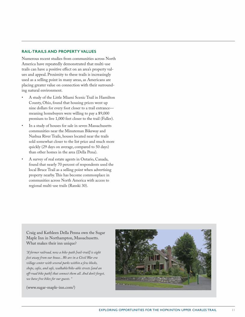
Craig and Kathleen Della Penna own the Sugar Maple Inn in Northampton, Massachusetts. What makes their inn unique?
“A former railroad, now a bike-path [rail-trail] is eight feet away from our house...We are in a Civil War era village center with several parks within a few blocks, shops, cafes, and safe, walkable/bike-able streets [and an off-road bike path] that connect them all. And don’t forget, we have free bikes for our guests. “
(www.sugar-maple-inn.com/)
12 EXPLORING OPPORTUNITIES FOR THE HOPKINTON UPPER CHARLES TRAIL
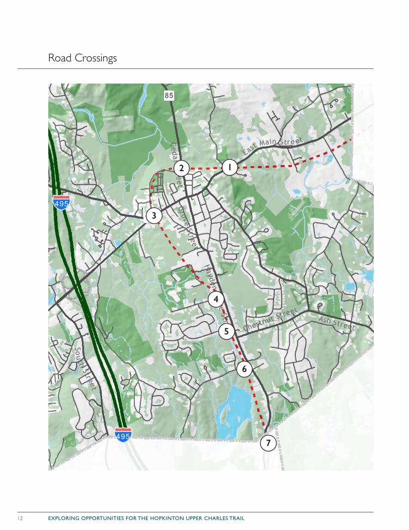
Road Crossings
WoodStreet
Ash Street
Flanders Road
Wes
tbor
oR
oad
Up
ton
Roa
d
Cedar Stre
et
Highland Street
Southville Road
Sou
thStreet
East Main Street
Washington Street
Prentic e Street
Oak Street
Hayden Row
e Street
West Main
Stre
et
Hopkinton Road
Purchase
Street
Main Street
Cordaville Road
Chestnut Street
Camp Street
Union Street
We stUni
onSt
reet
ProspectStre
etSum
mer Street
High
Stre
et
Grove Street
Wav
erly
Str
eet
Milk Street
Pleasant Street
Milford Street
West Main
Stre
et
Ce
dar
Str e
et
East
Ma i
nSt
reet
Hopkinton Road
Main S t r eet
Cord
aville Road
§̈¦495
§̈¦90
§̈¦90
§̈¦495
")85
Åõ135
DATA SOURCE: Wetlands, Waterbodies, RoadsOffice of Geographic Information (MassGIS), Commonwealth of Massachusetts, MassIT
OrthophotographyNAIP 2014Geospatial Data Gateway
¯0 1 2.5Miles
Town of Hopkinton, Mass.
12
3
4
5
6
7
13EXPLORING OPPORTUNITIES FOR THE HOPKINTON UPPER CHARLES TRAIL
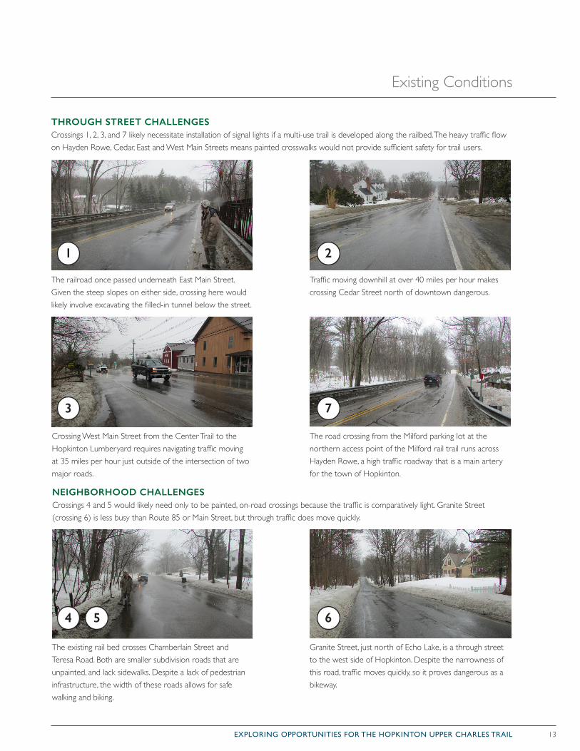
The existing rail bed crosses Chamberlain Street and Teresa Road. Both are smaller subdivision roads that are unpainted, and lack sidewalks. Despite a lack of pedestrian infrastructure, the width of these roads allows for safe walking and biking.
Granite Street, just north of Echo Lake, is a through street to the west side of Hopkinton. Despite the narrowness of this road, traffic moves quickly, so it proves dangerous as a bikeway.
Crossing West Main Street from the Center Trail to the Hopkinton Lumberyard requires navigating traffic moving at 35 miles per hour just outside of the intersection of two major roads.
Traffic moving downhill at over 40 miles per hour makes crossing Cedar Street north of downtown dangerous.
The railroad once passed underneath East Main Street. Given the steep slopes on either side, crossing here would likely involve excavating the filled-in tunnel below the street.
The road crossing from the Milford parking lot at the northern access point of the Milford rail trail runs across Hayden Rowe, a high traffic roadway that is a main artery for the town of Hopkinton.
THROUGH STREET CHALLENGESCrossings 1, 2, 3, and 7 likely necessitate installation of signal lights if a multi-use trail is developed along the railbed. The heavy traffic flow on Hayden Rowe, Cedar, East and West Main Streets means painted crosswalks would not provide sufficient safety for trail users.
NEIGHBORHOOD CHALLENGESCrossings 4 and 5 would likely need only to be painted, on-road crossings because the traffic is comparatively light. Granite Street (crossing 6) is less busy than Route 85 or Main Street, but through traffic does move quickly.
1
3
2
4 5
7
6
Existing Conditions
14 EXPLORING OPPORTUNITIES FOR THE HOPKINTON UPPER CHARLES TRAIL
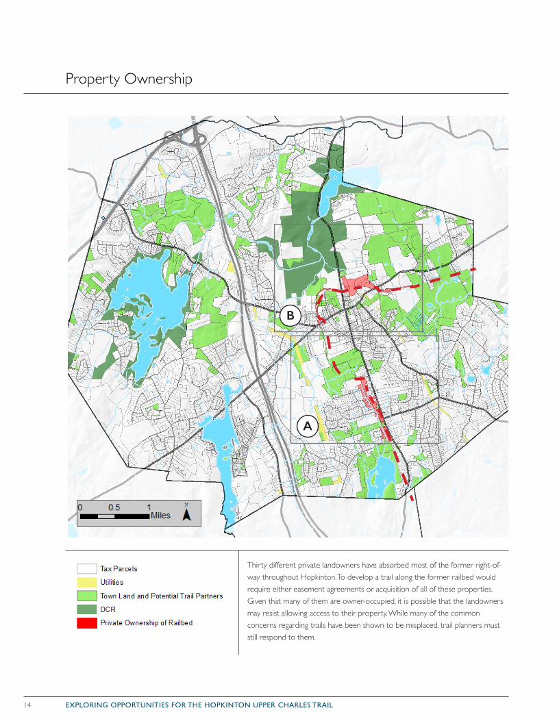
Property Ownership
Thirty different private landowners have absorbed most of the former right-of-way throughout Hopkinton. To develop a trail along the former railbed would require either easement agreements or acquisition of all of these properties. Given that many of them are owner-occupied, it is possible that the landowners may resist allowing access to their property. While many of the common concerns regarding trails have been shown to be misplaced, trail planners must still respond to them.
B
A
15EXPLORING OPPORTUNITIES FOR THE HOPKINTON UPPER CHARLES TRAIL
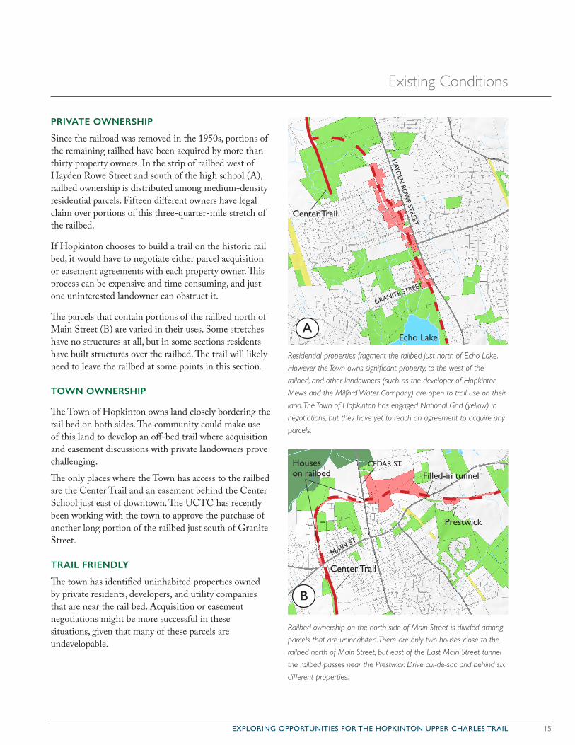
Railbed ownership on the north side of Main Street is divided among
parcels that are uninhabited. There are only two houses close to the
railbed north of Main Street, but east of the East Main Street tunnel
the railbed passes near the Prestwick Drive cul-de-sac and behind six
different properties.
PRIVATE OWNERSHIP
Since the railroad was removed in the 1950s, portions of the remaining railbed have been acquired by more than thirty property owners. In the strip of railbed west of Hayden Rowe Street and south of the high school (A), railbed ownership is distributed among medium-density residential parcels. Fifteen different owners have legal claim over portions of this three-quarter-mile stretch of the railbed.
If Hopkinton chooses to build a trail on the historic rail bed, it would have to negotiate either parcel acquisition or easement agreements with each property owner. This process can be expensive and time consuming, and just one uninterested landowner can obstruct it.
The parcels that contain portions of the railbed north of Main Street (B) are varied in their uses. Some stretches have no structures at all, but in some sections residents have built structures over the railbed. The trail will likely need to leave the railbed at some points in this section.
TOWN OWNERSHIP
The Town of Hopkinton owns land closely bordering the rail bed on both sides. The community could make use of this land to develop an off-bed trail where acquisition and easement discussions with private landowners prove challenging.
The only places where the Town has access to the railbed are the Center Trail and an easement behind the Center School just east of downtown. The UCTC has recently been working with the town to approve the purchase of another long portion of the railbed just south of Granite Street.
TRAIL FRIENDLY
The town has identified uninhabited properties owned by private residents, developers, and utility companies that are near the rail bed. Acquisition or easement negotiations might be more successful in these situations, given that many of these parcels are undevelopable.
Residential properties fragment the railbed just north of Echo Lake.
However the Town owns significant property, to the west of the
railbed, and other landowners (such as the developer of Hopkinton
Mews and the Milford Water Company) are open to trail use on their
land. The Town of Hopkinton has engaged National Grid (yellow) in
negotiations, but they have yet to reach an agreement to acquire any
parcels.
MAIN ST.
Filled-in tunnelCEDAR ST.
Center Trail
Prestwick
Houses on railbed
AA
B
GRANITE STREET
HAYD
EN RO
WE STREET
Echo Lake
Center Trail
Existing Conditions
16 EXPLORING OPPORTUNITIES FOR THE HOPKINTON UPPER CHARLES TRAIL
Topography and Geology
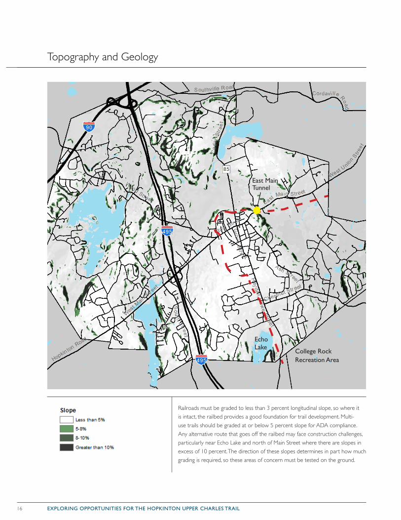
Railroads must be graded to less than 3 percent longitudinal slope, so where it is intact, the railbed provides a good foundation for trail development. Multi-use trails should be graded at or below 5 percent slope for ADA compliance. Any alternative route that goes off the railbed may face construction challenges, particularly near Echo Lake and north of Main Street where there are slopes in excess of 10 percent. The direction of these slopes determines in part how much grading is required, so these areas of concern must be tested on the ground.
East Main Tunnel
Echo Lake
College Rock Recreation Area
17EXPLORING OPPORTUNITIES FOR THE HOPKINTON UPPER CHARLES TRAIL
TOPOGRAPHY & GEOLOGY
Hilly terrain and abundant ledge characterize Hopkinton’s topography. The lowest elevations in town are approximately 250 feet above sea level, and high points are approximately 550 to 586 feet above sea level. The lower elevations tend to occur in the eastern and northern sections, with the topography rising towards the central and southern portions of the town.
The last glacial event 12,000 years ago created this land-scape. Ice up to one mile thick carried away much of the soil, eroded the bedrock, and transported boulders (known as glacial erratics) to create Hopkinton’s rocky landscape. The bedrock underlying the area consists almost entirely of granite, with some schist. When the ice receded, only a thin layer of glacial till was deposited over the bedrock.
These characteristics dictate many of the challenges that the multi-use trail faces. The northern portion of the trail would require grading to safely navigate the steep slopes outside of the railbed. The shallow soils in this area make grading even more challenging because significant changes to the topography would require altering the bedrock.
These tough-to-navigate slopes likely motivated the developers of the old railroad route to blast a tunnel under East Main Street. Tunnels are generally used as a solution when the existing topography provides no other choice for passage. The off-bed options for the proposed railbed will require further site study to determine routes that require the least labor and lowest costs.
Glacial erratics could prove challenging to building a trail off of the railbed in the College Rock area in south-ern Hopkinton and northeast of downtown Hopkinton. While a trail must circumvent these large stones, or alternately move or break up smaller ones, this could allow for the trail to access these erratics, providing addi-tional rock-climbing and hiking opportunities for Upper Charles communities.
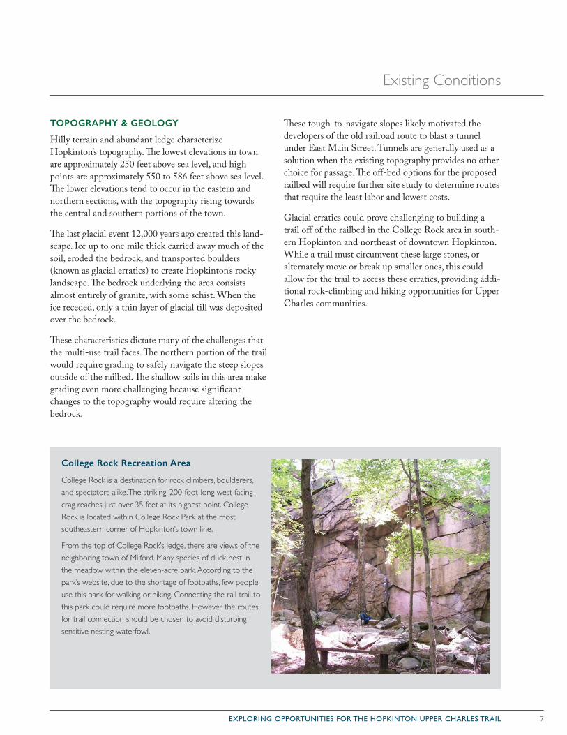
College Rock Recreation Area
College Rock is a destination for rock climbers, boulderers, and spectators alike. The striking, 200-foot-long west-facing crag reaches just over 35 feet at its highest point. College Rock is located within College Rock Park at the most southeastern corner of Hopkinton’s town line.
From the top of College Rock’s ledge, there are views of the neighboring town of Milford. Many species of duck nest in the meadow within the eleven-acre park. According to the park’s website, due to the shortage of footpaths, few people use this park for walking or hiking. Connecting the rail trail to this park could require more footpaths. However, the routes for trail connection should be chosen to avoid disturbing sensitive nesting waterfowl.
Existing Conditions
18 EXPLORING OPPORTUNITIES FOR THE HOPKINTON UPPER CHARLES TRAIL
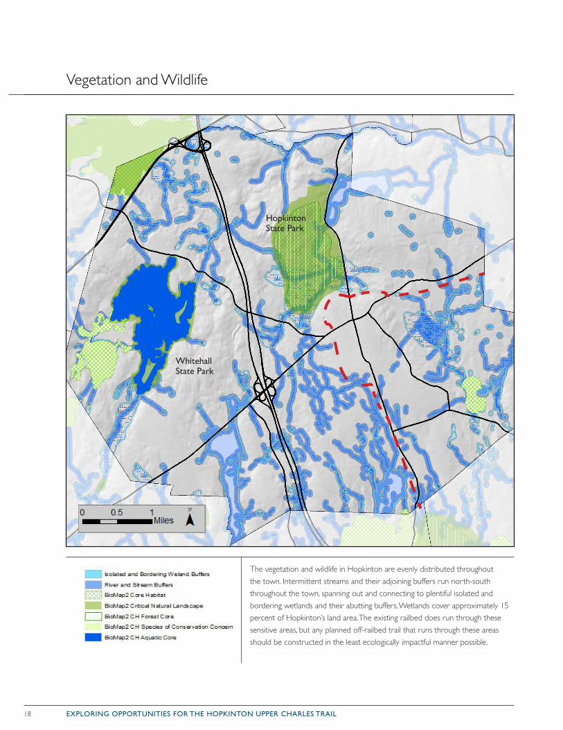
Vegetation and Wildlife
The vegetation and wildlife in Hopkinton are evenly distributed throughout the town. Intermittent streams and their adjoining buffers run north-south throughout the town, spanning out and connecting to plentiful isolated and bordering wetlands and their abutting buffers. Wetlands cover approximately 15 percent of Hopkinton’s land area. The existing railbed does run through these sensitive areas, but any planned off-railbed trail that runs through these areas should be constructed in the least ecologically impactful manner possible.
Hopkinton State Park
Whitehall State Park
19EXPLORING OPPORTUNITIES FOR THE HOPKINTON UPPER CHARLES TRAIL
WETLANDS
The Hopkinton Conservation Commission considers areas within identified wetland buffer zones to be vul-nerable habitats that require protection. Introducing a multi-use trail within these buffer zones can have harm-ful impacts when conducted improperly. However, if trails are planned, designed, and constructed carefully, in consultation with and with the approval of the Conservation Commission, they can provide greater awareness to the value of the wetlands, without disrupt-ing their ecological functions.
The existing railbed does not run through any large wet-land areas. It does, however, cross over minor intermit-tent stream beds along its route. Trail planners should be aware of the locations of wetlands when laying out trail spurs and alternatives to the railbed.
To minimize the impact on wetlands, trails can run along boardwalks through wetlands. Boardwalks cost more than paved trails, but their impact on wetland hab-itat and surface water flows is minimal (Kusler et al 9). Additionally, a trail located along the immediate shore of a wetland is often flooded or muddy a portion of the year. However, a boardwalk should not be constructed in highly sensitive areas with rare or endangered plants or animals; high traffic areas can disturb wildlife, such as bird nesting sites. Boardwalks through more stable wet-lands would also permit access to particularly scenic locations for recreation and educational use. Plum Island National Wildlife Refuge in Massachusetts is a prime example of boardwalk construction through wetlands (Kusler et al 5).
STREAMS
Creeks and streams, including intermittent streams, assist with stormwater management, flood control, and groundwater protection. During spring, summer, and fall these streams carry snow-melt and storm runoff across the landscape, thereby preventing dangerous volumes and flows from spilling over roadways and property. This broad, seasonal dispersal also allows for larger volumes of water to infiltrate into the ground, recharging groundwa-ter supplies. Streams also provide wildlife habitat and recreation values.
Because the moist soils that border intermittent streams
are significantly richer in vegetation and flowering/fruit-ing plant life, these areas often have more food sources for wildlife than upland areas. During all seasons, but especially in winter and spring, intermittent streams act as essential corridors for animal movement when food is scarce. Crossing these streams is possible, but future planners and potential users should be mindful of wild-life that use these streams for migration or habitat.
IMPERVIOUS SURFACES
According to Hopkinton Wetlands Protection Regulations, the construction of impervious surfaces, such as a paved multi-use trail, in watersheds negatively impacts the quantity and quality of stormwater runoff and affects important groundwater characteristics. Impervious surfaces can significantly reduce surface
A wetland is a land area that is saturated with water, either permanently or seasonally, such that it takes on the characteristics of a distinct ecosystem. Hopkinton requires a 100 foot buffer for wetlands.
Intermittent streams flow seasonally when the water table is high, such as during and after periods of heavy or steady rain. These steams require a 100-foot buffer.
Perennial streams have continuous flow in parts of its stream bed all year round during years of normal rainfall. These streams require a 200 foot buffer
A Core Habitat is a defined area of critical habitat for a species.
Forest Cores are large, intact forests that are least impacted by roads and development.
Aquatic Cores are intact river corridors within which important physical and ecological processes of the river or stream occur.
Critical Natural Landscapes complement Core Habitat and include large natural Landscape Blocks that provide habitat for wide-ranging native species, support intact ecological processes, maintain connectivity among habitats, and enhance ecological resilience. They include buffering uplands around coastal, wetland, and aquatic Core Habitats.
Species of Conservation Concern are species that are declining or appear to be in need of concentrated conservation actions.
Existing Conditions
20 EXPLORING OPPORTUNITIES FOR THE HOPKINTON UPPER CHARLES TRAIL
infiltration, increasing flooding problems, by increasing stormwater runoff volumes and redirecting water flows within a watershed. A paved trail may direct surface and stormwater flow patterns away from wetlands and com-promise necessary hydrological conditions needed to preserve wetland and the wildlife that inhabit them.
WILDLIFE
The Massachusetts Department of Fish and Game, through the Division of Fisheries and Wildlife’s Natural Heritage & Endangered Species Program (NHESP), and The Nature Conservancy’s Massachusetts Program developed Biomap2 to protect the state’s biodiversity, ensuring the long-term endurance of rare and other native species and their habitats, natural communities, and diverse ecosystems.
Biomap2 Core Habitats in Hopkinton are areas critical for the long-term persistence of rare species and other species of conservation concern. Areas delineated as Critical Natural Landscape by the NHESP include buf-fers around wetland areas and aquatic Core Habitats.
Protecting these Core Habitats contributes to the con-servation of natural biodiversity and habitats. Proper trail planning should conserve these lands. Where appropri-
ate, trail connections to such areas could help to educate the public about them. In some situations, properly designed trails can also help create habitat connections.
The 558-acre Hopkinton State Park, north of Hopkinton’s downtown, is defined as a Critical Natural Landscape and a Core Habitat area. Hopkinton State Park also includes a Forest Core. Forest Cores support many bird species by providing a core habitat protected from the impacts of roads and development, while main-taining ecological processes found only in unfragmented forest patches. The Hopkinton State Park’s Forest Core specifically supports the black-throated green warbler, which is a Species of Critical Concern.
A population of spotted turtles, once a Species of Critical Concern and still of interest for the conservation of the species, call Hopkinton State Park home. This Critical Natural Landscape offers these turtles the large, unfragmented habitat that they need for their annual migration. Roadways that cross migration routes are a major threat to the turtle. While it is known that roads prove detrimental, future trail development should seek further investigation into a potential trails impact on this species of turtle.
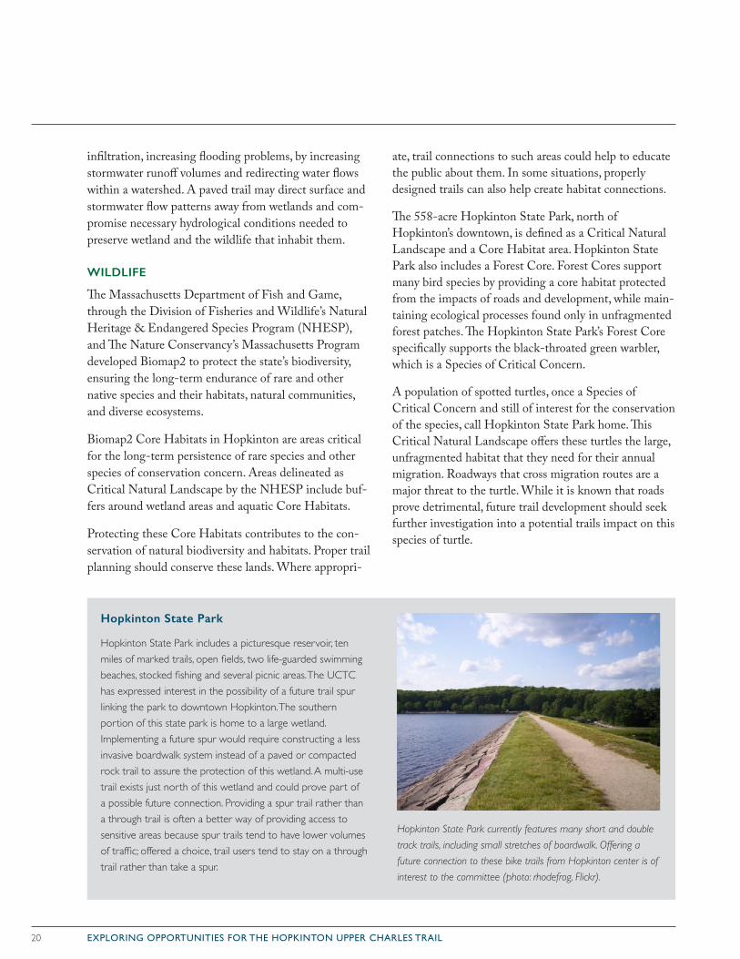
Hopkinton State Park
Hopkinton State Park includes a picturesque reservoir, ten miles of marked trails, open fields, two life-guarded swimming beaches, stocked fishing and several picnic areas. The UCTC has expressed interest in the possibility of a future trail spur linking the park to downtown Hopkinton. The southern portion of this state park is home to a large wetland. Implementing a future spur would require constructing a less invasive boardwalk system instead of a paved or compacted rock trail to assure the protection of this wetland. A multi-use trail exists just north of this wetland and could prove part of a possible future connection. Providing a spur trail rather than a through trail is often a better way of providing access to sensitive areas because spur trails tend to have lower volumes of traffic; offered a choice, trail users tend to stay on a through trail rather than take a spur.
Hopkinton State Park currently features many short and double
track trails, including small stretches of boardwalk. Offering a
future connection to these bike trails from Hopkinton center is of
interest to the committee (photo: rhodefrog, Flickr).
21EXPLORING OPPORTUNITIES FOR THE HOPKINTON UPPER CHARLES TRAIL
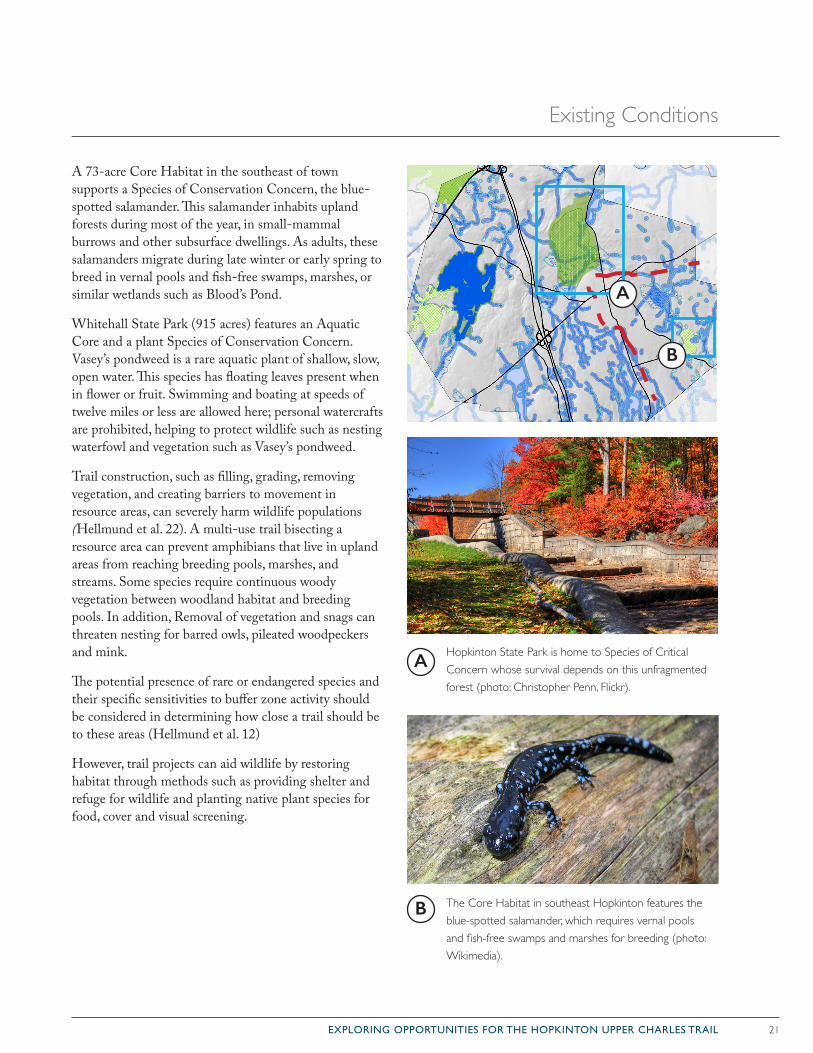
A 73-acre Core Habitat in the southeast of town supports a Species of Conservation Concern, the blue-spotted salamander. This salamander inhabits upland forests during most of the year, in small-mammal burrows and other subsurface dwellings. As adults, these salamanders migrate during late winter or early spring to breed in vernal pools and fish-free swamps, marshes, or similar wetlands such as Blood’s Pond.
Whitehall State Park (915 acres) features an Aquatic Core and a plant Species of Conservation Concern. Vasey’s pondweed is a rare aquatic plant of shallow, slow, open water. This species has floating leaves present when in flower or fruit. Swimming and boating at speeds of twelve miles or less are allowed here; personal watercrafts are prohibited, helping to protect wildlife such as nesting waterfowl and vegetation such as Vasey’s pondweed.
Trail construction, such as filling, grading, removing vegetation, and creating barriers to movement in resource areas, can severely harm wildlife populations (Hellmund et al. 22). A multi-use trail bisecting a resource area can prevent amphibians that live in upland areas from reaching breeding pools, marshes, and streams. Some species require continuous woody vegetation between woodland habitat and breeding pools. In addition, Removal of vegetation and snags can threaten nesting for barred owls, pileated woodpeckers and mink.
The potential presence of rare or endangered species and their specific sensitivities to buffer zone activity should be considered in determining how close a trail should be to these areas (Hellmund et al. 12)
However, trail projects can aid wildlife by restoring habitat through methods such as providing shelter and refuge for wildlife and planting native plant species for food, cover and visual screening.
Hopkinton State Park is home to Species of Critical Concern whose survival depends on this unfragmented forest (photo: Christopher Penn, Flickr).
The Core Habitat in southeast Hopkinton features the blue-spotted salamander, which requires vernal pools and fish-free swamps and marshes for breeding (photo: Wikimedia).
A
B
A
B
Existing Conditions
22 EXPLORING OPPORTUNITIES FOR THE HOPKINTON UPPER CHARLES TRAIL
Trail Type Options
RAIL-TRAILS
The rail-trail format is the default for most of the Upper Charles Trail, and is the most common approach for regional trails nationwide. This format uses the original physical corridor from an abandoned rail line as a wide multi-use path. Benefits• Typically the well-defined corridor formed by a former
rail line makes the trail-planning and construction process relatively straightforward.
• Rail-trails usually do not require significant grading, as railroads were graded to a maximum of 3 percent slope.
• Less vegetation removal is necessary, and as a result, destruction of habitat tends to be minimized.
• Rail corridors provide smooth, direct routes that can lend continuity of travel to a multi-use path —especially useful for commuting purposes. Biking/walking connections between towns are often most directly completed by using rail corridors.
Challenges• Acquiring access to the railbed property can be a
complicated and time-consuming process, depending on the number of property owners involved and their attitude toward a proposed trail.
• Depending on the history of a defunct rail line, the physical conditions surrounding its railbed may have changed, making construction more complicated. In Hopkinton’s case, structures (houses and sheds) have been built atop the railbed in places, the structural integrity of the railbed has been compromised in other locations, and a major tunnel has been filled in.
• Railroads were designed for limited access at very specific points such as stations or loading docks. This layout could limit access points to a trail built over the railbed.
Questions• How frequently along the trail must there be access/
exit points?
• Does using the trail make any additional funding sources available?
• What is the attitude of any abutters to the trail?
WOODLAND TRAILS
In places where the rail corridor is unavailable for trail use, or where additional paths within the trail network are desired, the woodland approach uses the multi-use trail to link patches of undeveloped land. Benefits• Green spaces can lend a scenic quality to the trail-
going experience. The trail’s character changes as it moves through the landscape. (Hopkinton’s landscape, in particular, is strikingly diverse, featuring dense hardwood forest cover, broad wetland areas, numerous streams, and glacially deposited boulders.)
• If planned with care, woodland trails can serve as travel corridors that benefit both the human and wildlife populations at once. Trail establishment can lead to protection of the surrounding swath of green space that might otherwise face development pressures.
• Trails that run through green space can serve educational purposes. They can provide interpretive opportunities and offer nearby community members convenient access to the natural environment.
• Often, these areas already host frequently used unimproved trails that could be converted into accessible multi-use paths.
• Compared to planning trails along rail corridors or next to roadways, trails that use open space may allow planners more flexibility in working around obstacles to the trail route.
Given the varying constraints and opportunities in Hopkinton, different multi-use path types may be appropriate for dif-ferent portions of the route. This section outlines three trail types—rail-trail, woodland trail, and roadside trail—and explores, broadly, the benefits and challenges that each presents for Hopkinton’s stretch of the Upper Charles Trail. Each trail type discussion also identifies some of the key questions that will arise for the Town and the trail designers to con-sider. The latter part of this chapter will introduce the route options for different segments of the trail.
23EXPLORING OPPORTUNITIES FOR THE HOPKINTON UPPER CHARLES TRAIL
Challenges• Some undeveloped land is undeveloped because is has
significant physical obstacles. Hopkinton’s landscape presents steep slopes, wetlands, and rocky terrain. Earth-moving, bridges, or stilted trail sections could be necessary, and tend to come with a higher price tag. Significant changes to the landscape would have an impact on its ecosystem. Designers should work with an ecologist to understand how a trail could be constructed to minimize impact.
• Private owners of undeveloped land may be unwilling to allow trail access.
Questions• What would be the environmental impact of a trail
through undeveloped areas? Would it disturb the habitat of any threatened species?
• Would portions of the trail require a boardwalk, and, if so, are soils deep enough to support this?
• How do the environmental and construction costs of a woodland compare to the legal and other costs associated with a trail that stays on the railbed?
ROADSIDE TRAILS
The incorporation of a multi-use path into the space along a street or road faces different challenges, and presents distinct benefits, depending on the character of the road and factors such as right-of-way length, existing sidewalks, and on-street parking. While some roads suc-cessfully incorporate (separated) bike lanes into the gen-eral traffic flow, the path type considered here for Hopkinton is a joined, two-way facility, physically sepa-rated from traffic by bollards, a raised or landscaped median, on-street parking, or otherwise.Benefits• Multi-use paths along roadways gain from and
contribute to the character of the particular road or street.
• In denser town centers, where more destinations are in walking or biking distance, roadside paths can be especially beneficial. In cases where expanded car access has made streets unfriendly to pedestrians and bicyclists, these paths can create breathing room.
• Roadside trails that run through a downtown area can prove beneficial in a number of interrelated ways.
They bring an increase in foot and bike traffic into the town on a daily basis —from both the surrounding neighborhood and the broader region. This tends to have a positive effect on businesses near the trail, and, in many cases, attracts new businesses such as shops, restaurants, ice cream stands, and B&Bs. This type of path has been shown to increase the economic vibrancy of town centers.
• Where a multi-use path runs along a busy roadway, it could provide a viable alternative to car travel in some instances. People are often uncomfortable walking or biking along a road’s shoulder, but a physically separate path alleviates this concern.
• The high visibility of the trail allays security concerns, and improves overall trail safety.
• As an existing roadway, these routes generally have fewer physical or environmental challenges to navigate.
Challenges• Along streets in a busy and more densely developed
town center, the incorporation of a separated path within the street’s right-of-way could possibly result in the loss of some on-street parking. In places where traffic lane widths are significantly wider than ten feet, however, it may be possible to narrow lanes and maintain parking spaces.
• Small neighborhood streets often do not have the capacity to handle the heavy flow of trail users that a successful trail could attract.
• Requires space enough for a ten-to-fourteen-foot wide path along the road’s right-of-way, plus a buffer zone along the road. Along roads lined with houses, homeowners often landscape within the right-of-way.
Questions• Are there ongoing road infrastructure projects in town,
and could roadside trails be incorporated into these?
• How wide is the road right-of-way?
• How wide are the road’s traffic lanes? (Ten feet is considered an acceptable traffic lane width for roads with speeds up to forty miles per hour.)
The following section explores the opportunities for employing each trail type in different segments along the Hopkinton Upper Charles Trail.
24 EXPLORING OPPORTUNITIES FOR THE HOPKINTON UPPER CHARLES TRAIL
Continuing the Upper Charles Trail
In concept, the Upper Charles Trail will connect Hopkinton with Milford, Holliston, Sherborn, and Ashland along the defunct rail corridor that once linked these communities. However, due to the changes to the landscape and property ownership surrounding the railbed in the seven decades since, this seemingly straightforward proposition is not so easily executed.
Based on analysis of existing conditions (see pages 20-31) and feedback from municipal stakeholders and the UCTC, this section evaluates a series of route alternatives to further the UCTC’s planning process in 2015. These alternatives make use of the three general trail types discussed in the previous section: rail-trails, woodland trails, and roadside trails. This is not an exhaustive list of possible alternatives, and the routes discussed should be understood as conceptual at this point.
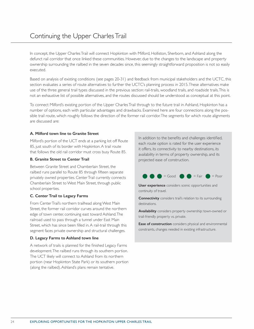
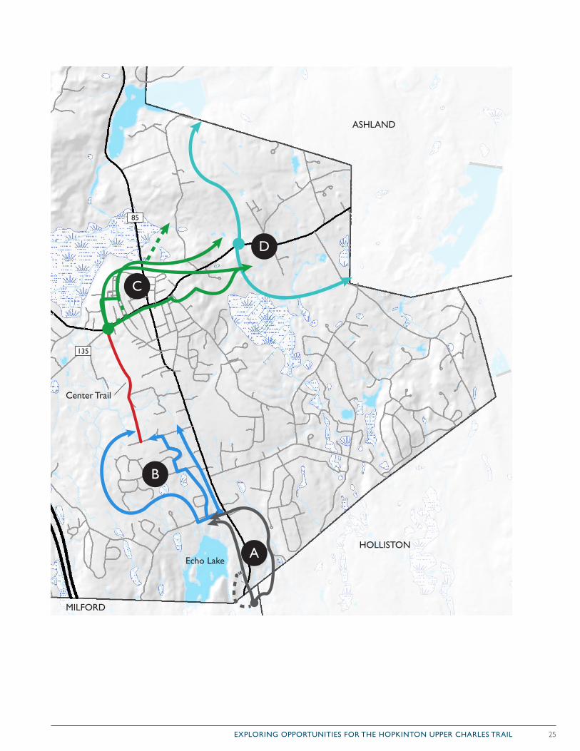
To connect Milford’s existing portion of the Upper Charles Trail through to the future trail in Ashland, Hopkinton has a number of options, each with particular advantages and drawbacks. Examined here are four connections along the pos-sible trail route, which roughly follows the direction of the former rail corridor. The segments for which route alignments are discussed are:
A. Milford town line to Granite Street
Milford’s portion of the UCT ends at a parking lot off Route 85, just south of its border with Hopkinton. A trail route that follows the old rail corridor must cross busy Route 85.
B. Granite Street to Center Trail
Between Granite Street and Chamberlain Street, the railbed runs parallel to Route 85 through fifteen separate privately owned properties. Center Trail currently connects Chamberlain Street to West Main Street, through public school properties.
C. Center Trail to Legacy Farms
From Center Trail’s northern trailhead along West Main Street, the former rail corridor curves around the northern edge of town center, continuing east toward Ashland. The railroad used to pass through a tunnel under East Main Street, which has since been filled in. A rail-trail through this segment faces private ownership and structural challenges.
D. Legacy Farms to Ashland town line
A network of trails is planned for the finished Legacy Farms development. The railbed runs through its southern portion. The UCT likely will connect to Ashland from its northern portion (near Hopkinton State Park) or its southern portion (along the railbed). Ashland’s plans remain tentative.
In addition to the benefits and challenges identified, each route option is rated for the user experience it offers, its connectivity to nearby destinations, its availability in terms of property ownership, and its projected ease of construction.
= Good
User experience considers scenic opportunities and continuity of travel.
Connectivity considers trail’s relation to its surrounding destinations.
Availability considers property ownership: town-owned or trail-friendly property vs. private.
Ease of construction considers physical and environmental constraints, changes needed in existing infrastructure.
= Fair = Poor
25EXPLORING OPPORTUNITIES FOR THE HOPKINTON UPPER CHARLES TRAIL
A
B
C
D
Center Trail
ASHLAND
HOLLISTON
MILFORD
Echo Lake
135
85
26 EXPLORING OPPORTUNITIES FOR THE HOPKINTON UPPER CHARLES TRAIL
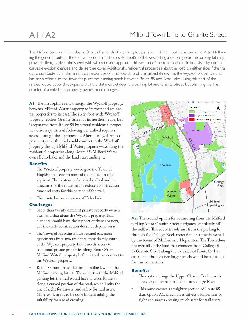
Milford Town Line to Granite StreetA1 / A2
The Milford portion of the Upper Charles Trail ends at a parking lot just south of the Hopkinton town line. A trail follow-ing the general route of the old rail corridor must cross Route 85 to the west. Siting a crossing near the parking lot may prove challenging given the speed with which drivers approach this section of the road, and the limited visibility due to curves, elevation changes, and dense tree cover. Additionally, residential properties abut the road on either side. If the trail can cross Route 85 in this area, it can make use of a narrow strip of the railbed (known as the Wyckoff property), that has been offered to the town for purchase, running north between Route 85 and Echo Lake. Using this part of the railbed would cover three-quarters of the distance between the parking lot and Granite Street, but planning the final quarter of a mile faces property ownership challenges.
A1: The first option runs through the Wyckoff property, between Milford Water property to its west and residen-tial properties to its east. The sixty-foot-wide Wyckoff property reaches Granite Street at its northern edge, but is separated from Route 85 by several residential proper-ties’ driveways. A trail following the railbed requires access through these properties. Alternatively, there is a possibility that the trail could connect to the Wyckoff property through Milford Water property—avoiding the residential properties along Route 85. Milford Water owns Echo Lake and the land surrounding it.Benefits• The Wyckoff property would give the Town of
Hopkinton access to most of the railbed in this segment. The existence of a raised railbed and the directness of the route means reduced construction time and costs for this portion of the trail.
• This route has scenic views of Echo Lake.Challenges• More than twenty different private property owners
own land that abuts the Wyckoff property. Trail planners should have the support of these abutters, but the trail’s construction does not depend on it.
• The Town of Hopkinton has secured easement agreements from two residents immediately south of the Wyckoff property, but it needs access to additional private properties along Route 85 or Milford Water’s property before a trail can connect to the Wyckoff property.
• Route 85 runs across the former railbed, where the Milford parking lot sits. To connect with the Milford parking lot, the trail would have to cross Route 85 along a curved portion of the road, which limits the line of sight for drivers, and safety for trail users. More work needs to be done in determining the suitability for a road crossing.
A2: The second option for connecting from the Milford parking lot to Granite Street navigates completely off the railbed. This route travels east from the parking lot through the College Rock recreation area that is owned by the towns of Milford and Hopkinton. The Town does not own all of the land that connects from College Rock to Granite Street along the east side of Route 85, but easements through two large parcels would be sufficient for this connection.
Benefits• This option brings the Upper Charles Trail near the
already popular recreation area at College Rock.
• This route crosses a straighter portion of Route 85 than option A1, which gives drivers a longer line of sight and makes crossing much safer for trail users.
Wyckoff
Echo Lake
MilfordWater
GRANITE STREET
CollegeRock
Milford parking lot
ROU
TE 85
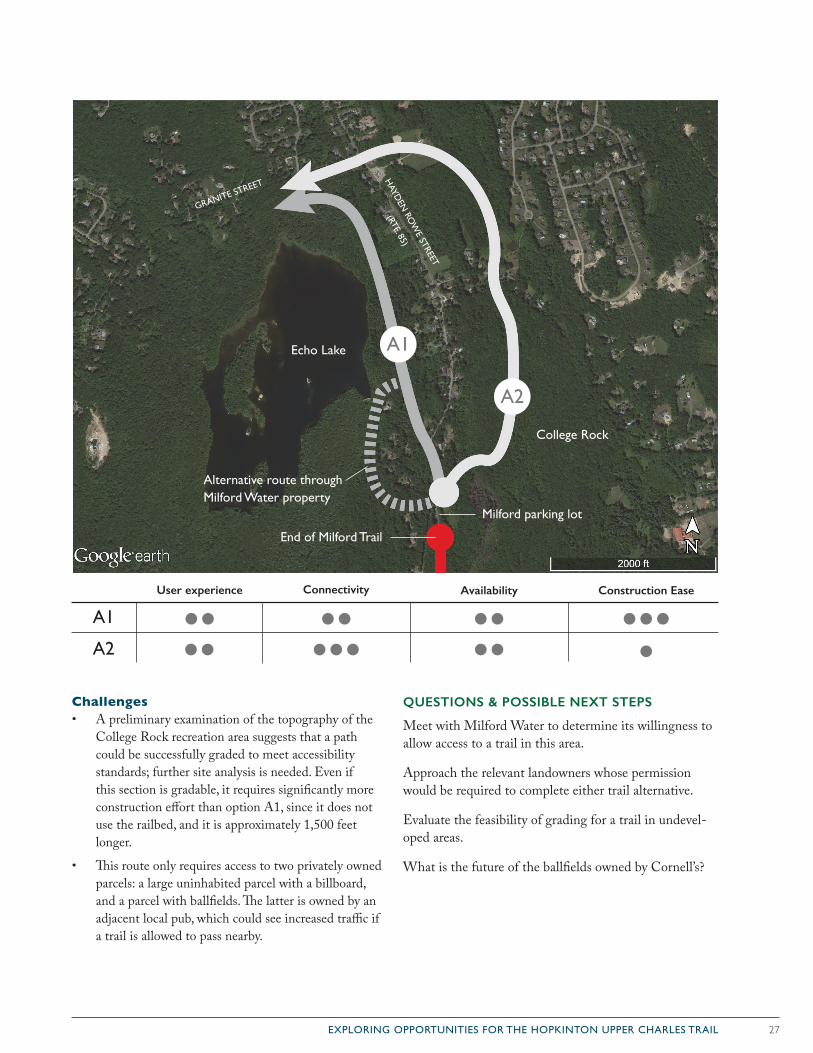
27EXPLORING OPPORTUNITIES FOR THE HOPKINTON UPPER CHARLES TRAIL
Challenges• A preliminary examination of the topography of the
College Rock recreation area suggests that a path could be successfully graded to meet accessibility standards; further site analysis is needed. Even if this section is gradable, it requires significantly more construction effort than option A1, since it does not use the railbed, and it is approximately 1,500 feet longer.
• This route only requires access to two privately owned parcels: a large uninhabited parcel with a billboard, and a parcel with ballfields. The latter is owned by an adjacent local pub, which could see increased traffic if a trail is allowed to pass nearby.
QUESTIONS & POSSIBLE NEXT STEPS
Meet with Milford Water to determine its willingness to allow access to a trail in this area.
Approach the relevant landowners whose permission would be required to complete either trail alternative.
Evaluate the feasibility of grading for a trail in undevel-oped areas.
What is the future of the ballfields owned by Cornell’s?
Milford parking lot
GRANITE STREET
HAYD
EN RO
WE STREET
(RTE. 85)A2
Echo Lake
End of Milford Trail
A1
College Rock
A1
A2
User experience Connectivity Availability Construction Ease
Alternative route through Milford Water property
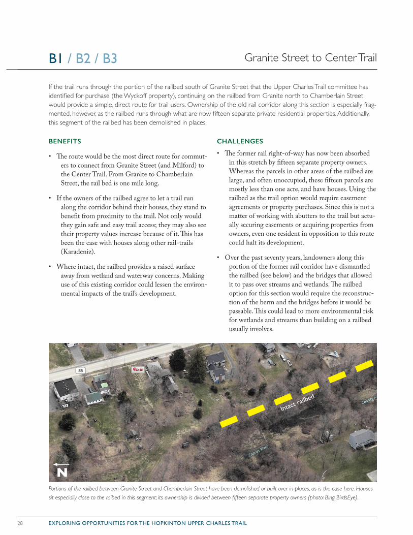
28 EXPLORING OPPORTUNITIES FOR THE HOPKINTON UPPER CHARLES TRAIL
BENEFITS
• The route would be the most direct route for commut-ers to connect from Granite Street (and Milford) to the Center Trail. From Granite to Chamberlain Street, the rail bed is one mile long.
• If the owners of the railbed agree to let a trail run along the corridor behind their houses, they stand to benefit from proximity to the trail. Not only would they gain safe and easy trail access; they may also see their property values increase because of it. This has been the case with houses along other rail-trails (Karadeniz).
• Where intact, the railbed provides a raised surface away from wetland and waterway concerns. Making use of this existing corridor could lessen the environ-mental impacts of the trail’s development.
CHALLENGES
• The former rail right-of-way has now been absorbed in this stretch by fifteen separate property owners. Whereas the parcels in other areas of the railbed are large, and often unoccupied, these fifteen parcels are mostly less than one acre, and have houses. Using the railbed as the trail option would require easement agreements or property purchases. Since this is not a matter of working with abutters to the trail but actu-ally securing easements or acquiring properties from owners, even one resident in opposition to this route could halt its development.
• Over the past seventy years, landowners along this portion of the former rail corridor have dismantled the railbed (see below) and the bridges that allowed it to pass over streams and wetlands. The railbed option for this section would require the reconstruc-tion of the berm and the bridges before it would be passable. This could lead to more environmental risk for wetlands and streams than building on a railbed usually involves.
If the trail runs through the portion of the railbed south of Granite Street that the Upper Charles Trail committee has identified for purchase (the Wyckoff property), continuing on the railbed from Granite north to Chamberlain Street would provide a simple, direct route for trail users. Ownership of the old rail corridor along this section is especially frag-mented, however, as the railbed runs through what are now fifteen separate private residential properties. Additionally, this segment of the railbed has been demolished in places.
Portions of the railbed between Granite Street and Chamberlain Street have been demolished or built over in places, as is the case here. Houses
sit especially close to the raibed in this segment; its ownership is divided between fifteen separate property owners (photo: Bing BirdsEye).
N
Granite Street to Center TrailB1 / B2 / B3
Intact railb
ed
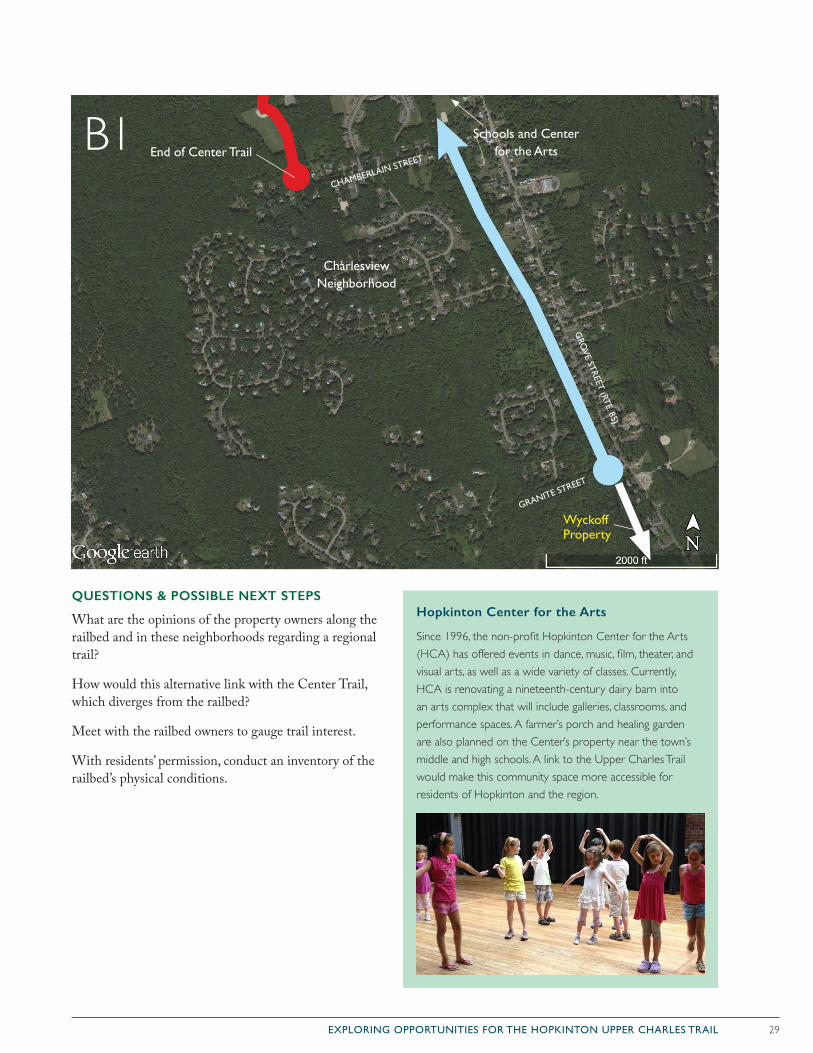
29EXPLORING OPPORTUNITIES FOR THE HOPKINTON UPPER CHARLES TRAIL
QUESTIONS & POSSIBLE NEXT STEPS
What are the opinions of the property owners along the railbed and in these neighborhoods regarding a regional trail?
How would this alternative link with the Center Trail, which diverges from the railbed?
Meet with the railbed owners to gauge trail interest.
With residents’ permission, conduct an inventory of the railbed’s physical conditions.
B1
Hopkinton Center for the Arts
Since 1996, the non-profit Hopkinton Center for the Arts (HCA) has offered events in dance, music, film, theater, and visual arts, as well as a wide variety of classes. Currently, HCA is renovating a nineteenth-century dairy barn into an arts complex that will include galleries, classrooms, and performance spaces. A farmer’s porch and healing garden are also planned on the Center’s property near the town’s middle and high schools. A link to the Upper Charles Trail would make this community space more accessible for residents of Hopkinton and the region.
GRO
VE STREET (RTE. 85)
GRANITE STREET
CHAMBERLAIN STREET
Charlesview Neighborhood
End of Center Trail
Wyckoff Property
Schools and Center for the Arts
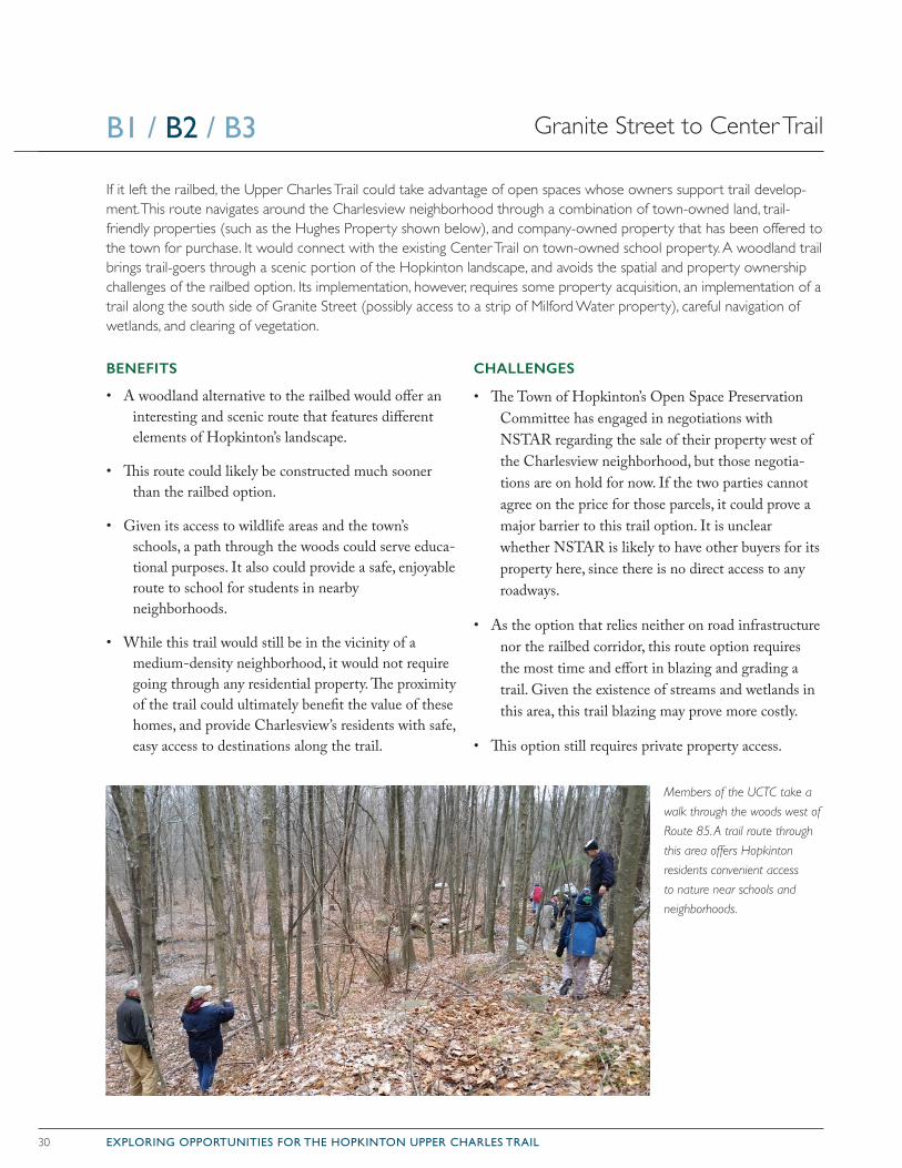
30 EXPLORING OPPORTUNITIES FOR THE HOPKINTON UPPER CHARLES TRAIL
BENEFITS
• A woodland alternative to the railbed would offer an interesting and scenic route that features different elements of Hopkinton’s landscape.
• This route could likely be constructed much sooner than the railbed option.
• Given its access to wildlife areas and the town’s schools, a path through the woods could serve educa-tional purposes. It also could provide a safe, enjoyable route to school for students in nearby neighborhoods.
• While this trail would still be in the vicinity of a medium-density neighborhood, it would not require going through any residential property. The proximity of the trail could ultimately benefit the value of these homes, and provide Charlesview’s residents with safe, easy access to destinations along the trail.
CHALLENGES
• The Town of Hopkinton’s Open Space Preservation Committee has engaged in negotiations with NSTAR regarding the sale of their property west of the Charlesview neighborhood, but those negotia-tions are on hold for now. If the two parties cannot agree on the price for those parcels, it could prove a major barrier to this trail option. It is unclear whether NSTAR is likely to have other buyers for its property here, since there is no direct access to any roadways.
• As the option that relies neither on road infrastructure nor the railbed corridor, this route option requires the most time and effort in blazing and grading a trail. Given the existence of streams and wetlands in this area, this trail blazing may prove more costly.
• This option still requires private property access.
If it left the railbed, the Upper Charles Trail could take advantage of open spaces whose owners support trail develop-ment. This route navigates around the Charlesview neighborhood through a combination of town-owned land, trail-friendly properties (such as the Hughes Property shown below), and company-owned property that has been offered to the town for purchase. It would connect with the existing Center Trail on town-owned school property. A woodland trail brings trail-goers through a scenic portion of the Hopkinton landscape, and avoids the spatial and property ownership challenges of the railbed option. Its implementation, however, requires some property acquisition, an implementation of a trail along the south side of Granite Street (possibly access to a strip of Milford Water property), careful navigation of wetlands, and clearing of vegetation.
Granite Street to Center TrailB1 / B2 / B3
Members of the UCTC take a
walk through the woods west of
Route 85. A trail route through
this area offers Hopkinton
residents convenient access
to nature near schools and
neighborhoods.
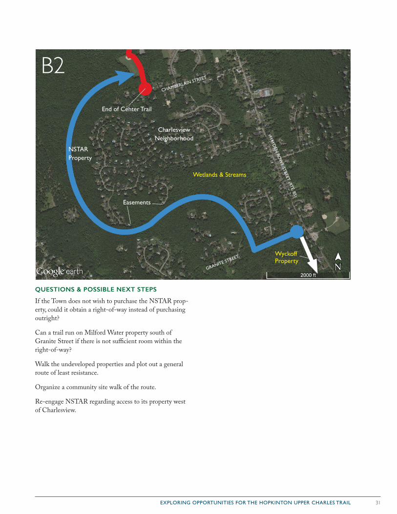
31EXPLORING OPPORTUNITIES FOR THE HOPKINTON UPPER CHARLES TRAIL
QUESTIONS & POSSIBLE NEXT STEPS
If the Town does not wish to purchase the NSTAR prop-erty, could it obtain a right-of-way instead of purchasing outright?
Can a trail run on Milford Water property south of Granite Street if there is not sufficient room within the right-of-way?
Walk the undeveloped properties and plot out a general route of least resistance.
Organize a community site walk of the route.
Re-engage NSTAR regarding access to its property west of Charlesview.
B2
HAYD
EN RO
WE STREET (RTE. 85)
GRANITE STREET
CHAMBERLAIN STREET
Charlesview Neighborhood
End of Center Trail
Wyckoff Property
Easements
NSTAR Property
Wetlands & Streams
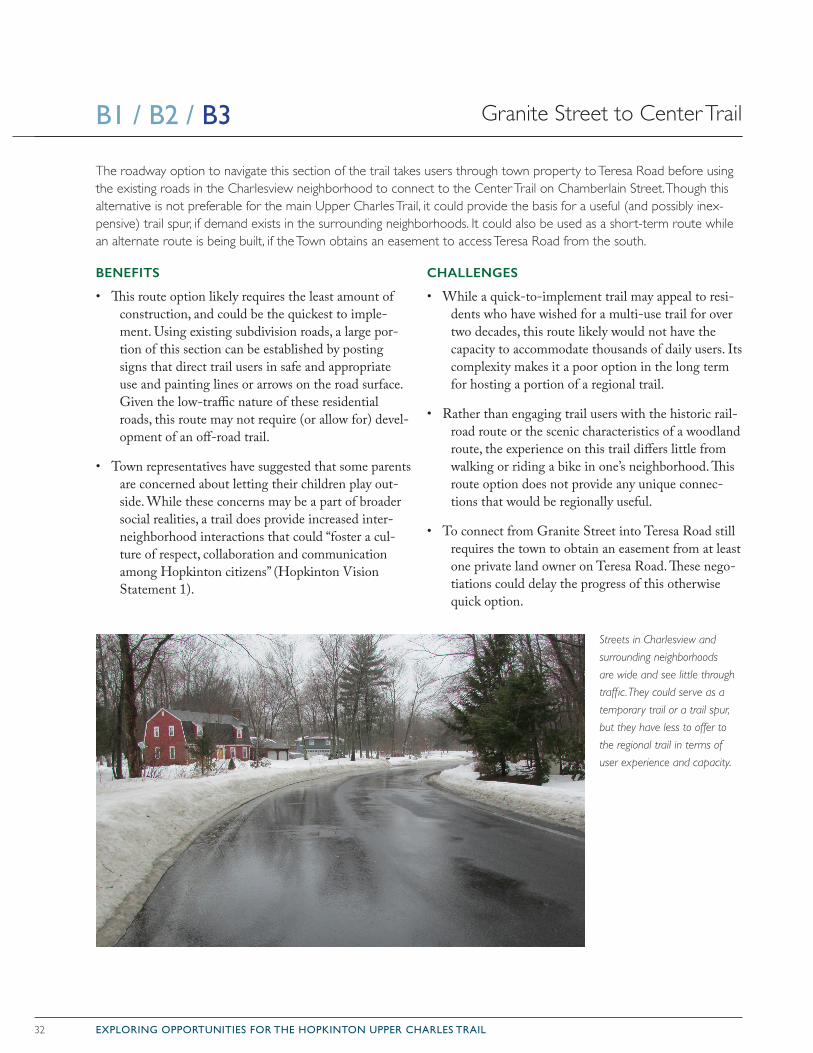
32 EXPLORING OPPORTUNITIES FOR THE HOPKINTON UPPER CHARLES TRAIL
BENEFITS
• This route option likely requires the least amount of construction, and could be the quickest to imple-ment. Using existing subdivision roads, a large por-tion of this section can be established by posting signs that direct trail users in safe and appropriate use and painting lines or arrows on the road surface. Given the low-traffic nature of these residential roads, this route may not require (or allow for) devel-opment of an off-road trail.
• Town representatives have suggested that some parents are concerned about letting their children play out-side. While these concerns may be a part of broader social realities, a trail does provide increased inter-neighborhood interactions that could “foster a cul-ture of respect, collaboration and communication among Hopkinton citizens” (Hopkinton Vision Statement 1).
CHALLENGES
• While a quick-to-implement trail may appeal to resi-dents who have wished for a multi-use trail for over two decades, this route likely would not have the capacity to accommodate thousands of daily users. Its complexity makes it a poor option in the long term for hosting a portion of a regional trail.
• Rather than engaging trail users with the historic rail-road route or the scenic characteristics of a woodland route, the experience on this trail differs little from walking or riding a bike in one’s neighborhood. This route option does not provide any unique connec-tions that would be regionally useful.
• To connect from Granite Street into Teresa Road still requires the town to obtain an easement from at least one private land owner on Teresa Road. These nego-tiations could delay the progress of this otherwise quick option.
The roadway option to navigate this section of the trail takes users through town property to Teresa Road before using the existing roads in the Charlesview neighborhood to connect to the Center Trail on Chamberlain Street. Though this alternative is not preferable for the main Upper Charles Trail, it could provide the basis for a useful (and possibly inex-pensive) trail spur, if demand exists in the surrounding neighborhoods. It could also be used as a short-term route while an alternate route is being built, if the Town obtains an easement to access Teresa Road from the south.
Streets in Charlesview and
surrounding neighborhoods
are wide and see little through
traffic. They could serve as a
temporary trail or a trail spur,
but they have less to offer to
the regional trail in terms of
user experience and capacity.
Granite Street to Center TrailB1 / B2 / B3
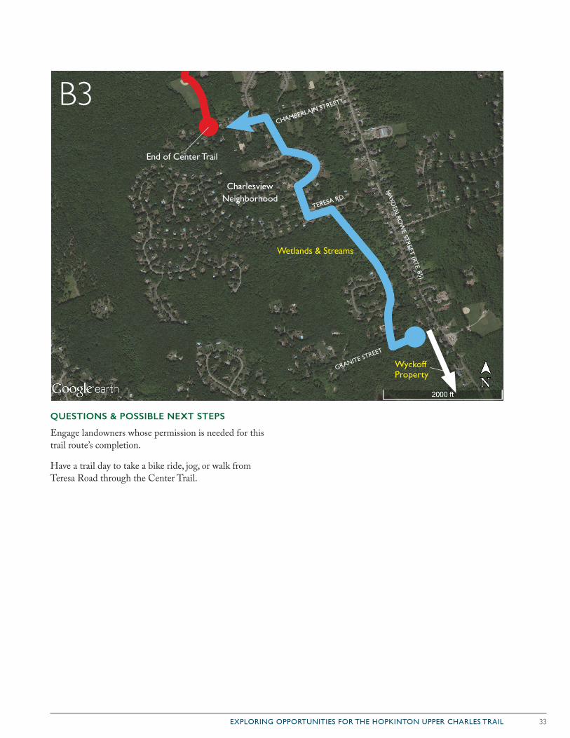
33EXPLORING OPPORTUNITIES FOR THE HOPKINTON UPPER CHARLES TRAIL
QUESTIONS & POSSIBLE NEXT STEPS
Engage landowners whose permission is needed for this trail route’s completion.
Have a trail day to take a bike ride, jog, or walk from Teresa Road through the Center Trail.
B3
HAYD
EN RO
WE STREET (RTE. 85)
GRANITE STREET
CHAMBERLAIN STREET
Charlesview Neighborhood
End of Center Trail
Wyckoff Property
Wetlands & Streams
TERESA RD.
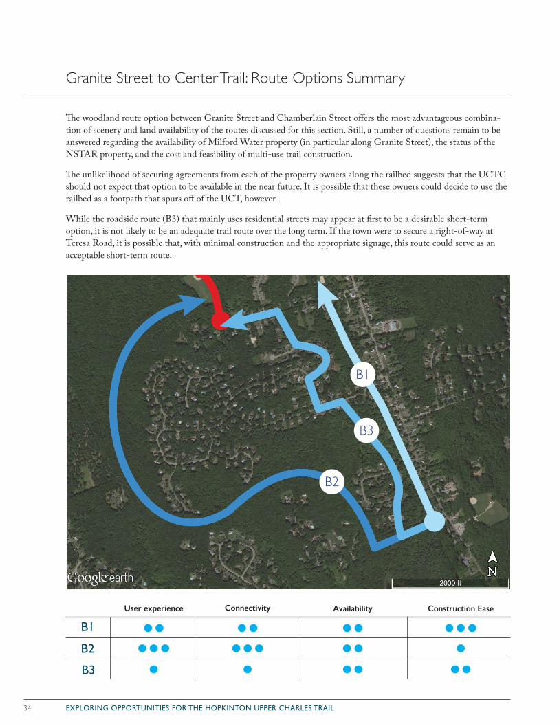
34 EXPLORING OPPORTUNITIES FOR THE HOPKINTON UPPER CHARLES TRAIL
The woodland route option between Granite Street and Chamberlain Street offers the most advantageous combina-tion of scenery and land availability of the routes discussed for this section. Still, a number of questions remain to be answered regarding the availability of Milford Water property (in particular along Granite Street), the status of the NSTAR property, and the cost and feasibility of multi-use trail construction.
The unlikelihood of securing agreements from each of the property owners along the railbed suggests that the UCTC should not expect that option to be available in the near future. It is possible that these owners could decide to use the railbed as a footpath that spurs off of the UCT, however.
While the roadside route (B3) that mainly uses residential streets may appear at first to be a desirable short-term option, it is not likely to be an adequate trail route over the long term. If the town were to secure a right-of-way at Teresa Road, it is possible that, with minimal construction and the appropriate signage, this route could serve as an acceptable short-term route.
Granite Street to Center Trail: Route Options Summary
B1
B2
User experience Connectivity Availability Construction Ease
B3
B1
B3
B2

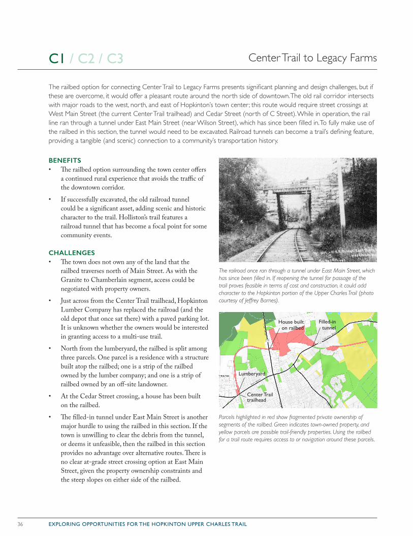
36 EXPLORING OPPORTUNITIES FOR THE HOPKINTON UPPER CHARLES TRAIL
BENEFITS• The railbed option surrounding the town center offers
a continued rural experience that avoids the traffic of the downtown corridor.
• If successfully excavated, the old railroad tunnel could be a significant asset, adding scenic and historic character to the trail. Holliston’s trail features a railroad tunnel that has become a focal point for some community events.
CHALLENGES• The town does not own any of the land that the
railbed traverses north of Main Street. As with the Granite to Chamberlain segment, access could be negotiated with property owners.
• Just across from the Center Trail trailhead, Hopkinton Lumber Company has replaced the railroad (and the old depot that once sat there) with a paved parking lot. It is unknown whether the owners would be interested in granting access to a multi-use trail.
• North from the lumberyard, the railbed is split among three parcels. One parcel is a residence with a structure built atop the railbed; one is a strip of the railbed owned by the lumber company; and one is a strip of railbed owned by an off-site landowner.
• At the Cedar Street crossing, a house has been built on the railbed.
• The filled-in tunnel under East Main Street is another major hurdle to using the railbed in this section. If the town is unwilling to clear the debris from the tunnel, or deems it unfeasible, then the railbed in this section provides no advantage over alternative routes. There is no clear at-grade street crossing option at East Main Street, given the property ownership constraints and the steep slopes on either side of the railbed.
The railbed option for connecting Center Trail to Legacy Farms presents significant planning and design challenges, but if these are overcome, it would offer a pleasant route around the north side of downtown. The old rail corridor intersects with major roads to the west, north, and east of Hopkinton’s town center ; this route would require street crossings at West Main Street (the current Center Trail trailhead) and Cedar Street (north of C Street). While in operation, the rail line ran through a tunnel under East Main Street (near Wilson Street), which has since been filled in. To fully make use of the railbed in this section, the tunnel would need to be excavated. Railroad tunnels can become a trail’s defining feature, providing a tangible (and scenic) connection to a community’s transportation history.
The railroad once ran through a tunnel under East Main Street, which has since been filled in. If reopening the tunnel for passage of the trail proves feasible in terms of cost and construction, it could add character to the Hopkinton portion of the Upper Charles Trail (photo courtesy of Jeffrey Barnes).
Parcels highlighted in red show fragmented private ownership of segments of the railbed. Green indicates town-owned property, and yellow parcels are possible trail-friendly properties. Using the railbed for a trail route requires access to or navigation around these parcels.
Center Trail to Legacy FarmsC1 / C2 / C3
Lumberyard
House built on railbed
Filled-in tunnel
Center Trail trailhead
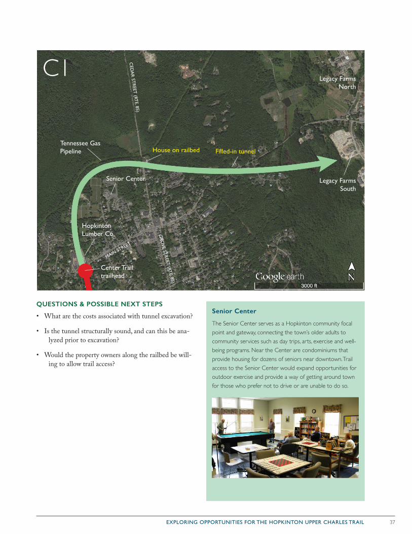
37EXPLORING OPPORTUNITIES FOR THE HOPKINTON UPPER CHARLES TRAIL
QUESTIONS & POSSIBLE NEXT STEPS
• What are the costs associated with tunnel excavation?
• Is the tunnel structurally sound, and can this be ana-lyzed prior to excavation?
• Would the property owners along the railbed be will-ing to allow trail access?
Senior Center
The Senior Center serves as a Hopkinton community focal point and gateway, connecting the town’s older adults to community services such as day trips, arts, exercise and well-being programs. Near the Center are condominiums that provide housing for dozens of seniors near downtown. Trail access to the Senior Center would expand opportunities for outdoor exercise and provide a way of getting around town for those who prefer not to drive or are unable to do so.
C1
Senior Center Legacy Farms South
Legacy Farms North
Tennessee Gas Pipeline House on railbed
Hopkinton Lumber Co.
MAIN STREET
GRO
VE ST
REET
(RTE. 85)
CED
AR
STR
EET (RT
E. 85)
Filled-in tunnel
Center Trail trailhead
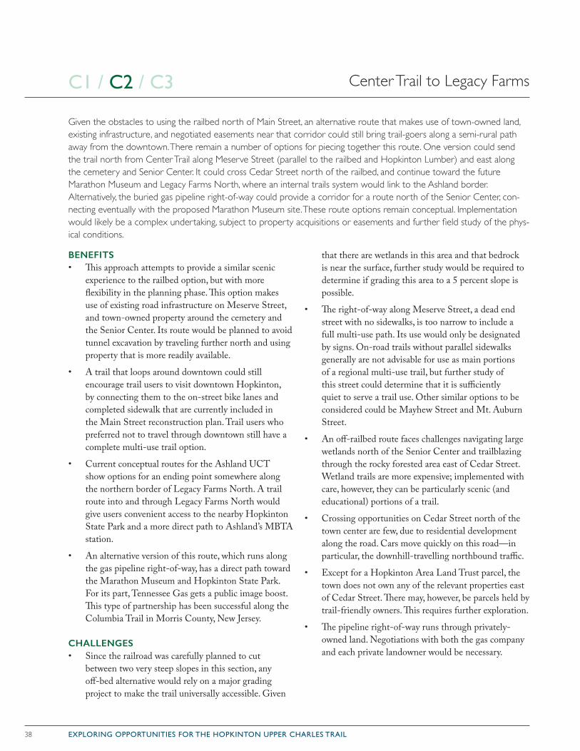
38 EXPLORING OPPORTUNITIES FOR THE HOPKINTON UPPER CHARLES TRAIL
BENEFITS• This approach attempts to provide a similar scenic
experience to the railbed option, but with more flexibility in the planning phase. This option makes use of existing road infrastructure on Meserve Street, and town-owned property around the cemetery and the Senior Center. Its route would be planned to avoid tunnel excavation by traveling further north and using property that is more readily available.
• A trail that loops around downtown could still encourage trail users to visit downtown Hopkinton, by connecting them to the on-street bike lanes and completed sidewalk that are currently included in the Main Street reconstruction plan. Trail users who preferred not to travel through downtown still have a complete multi-use trail option.
• Current conceptual routes for the Ashland UCT show options for an ending point somewhere along the northern border of Legacy Farms North. A trail route into and through Legacy Farms North would give users convenient access to the nearby Hopkinton State Park and a more direct path to Ashland’s MBTA station.
• An alternative version of this route, which runs along the gas pipeline right-of-way, has a direct path toward the Marathon Museum and Hopkinton State Park. For its part, Tennessee Gas gets a public image boost. This type of partnership has been successful along the Columbia Trail in Morris County, New Jersey.
CHALLENGES• Since the railroad was carefully planned to cut
between two very steep slopes in this section, any off-bed alternative would rely on a major grading project to make the trail universally accessible. Given
that there are wetlands in this area and that bedrock is near the surface, further study would be required to determine if grading this area to a 5 percent slope is possible.
• The right-of-way along Meserve Street, a dead end street with no sidewalks, is too narrow to include a full multi-use path. Its use would only be designated by signs. On-road trails without parallel sidewalks generally are not advisable for use as main portions of a regional multi-use trail, but further study of this street could determine that it is sufficiently quiet to serve a trail use. Other similar options to be considered could be Mayhew Street and Mt. Auburn Street.
• An off-railbed route faces challenges navigating large wetlands north of the Senior Center and trailblazing through the rocky forested area east of Cedar Street. Wetland trails are more expensive; implemented with care, however, they can be particularly scenic (and educational) portions of a trail.
• Crossing opportunities on Cedar Street north of the town center are few, due to residential development along the road. Cars move quickly on this road—in particular, the downhill-travelling northbound traffic.
• Except for a Hopkinton Area Land Trust parcel, the town does not own any of the relevant properties east of Cedar Street. There may, however, be parcels held by trail-friendly owners. This requires further exploration.
• The pipeline right-of-way runs through privately-owned land. Negotiations with both the gas company and each private landowner would be necessary.
Center Trail to Legacy Farms
Given the obstacles to using the railbed north of Main Street, an alternative route that makes use of town-owned land, existing infrastructure, and negotiated easements near that corridor could still bring trail-goers along a semi-rural path away from the downtown. There remain a number of options for piecing together this route. One version could send the trail north from Center Trail along Meserve Street (parallel to the railbed and Hopkinton Lumber) and east along the cemetery and Senior Center. It could cross Cedar Street north of the railbed, and continue toward the future Marathon Museum and Legacy Farms North, where an internal trails system would link to the Ashland border. Alternatively, the buried gas pipeline right-of-way could provide a corridor for a route north of the Senior Center, con-necting eventually with the proposed Marathon Museum site. These route options remain conceptual. Implementation would likely be a complex undertaking, subject to property acquisitions or easements and further field study of the phys-ical conditions.
C1 / C2 / C3
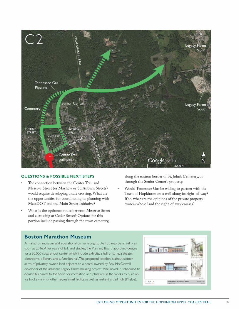
39EXPLORING OPPORTUNITIES FOR THE HOPKINTON UPPER CHARLES TRAIL
QUESTIONS & POSSIBLE NEXT STEPS
• The connection between the Center Trail and Meserve Street (or Mayhew or St. Auburn Streets) would require developing a safe crossing. What are the opportunities for coordinating its planning with MassDOT and the Main Street Initiative?
• What is the optimum route between Meserve Street and a crossing at Cedar Street? Options for this portion include passing through the town cemetery,
along the eastern border of St. John’s Cemetery, or through the Senior Center’s property.
• Would Tennessee Gas be willing to partner with the Town of Hopkinton on a trail along its right-of-way? If so, what are the opinions of the private property owners whose land the right-of-way crosses?
Boston Marathon MuseumA marathon museum and educational center along Route 135 may be a reality as soon as 2016. After years of talk and studies, the Planning Board approved designs for a 30,000-square-foot center which include exhibits, a hall of fame, a theater, classrooms, a library, and a function hall. The proposed location is about sixteen acres of privately owned land adjacent to a parcel owned by Roy MacDowell, developer of the adjacent Legacy Farms housing project. MacDowell is scheduled to donate his parcel to the town for recreation and plans are in the works to build an ice hockey rink or other recreational facility, as well as make it a trail hub (Phelps).
MESERVESTREET
MAYHEWSTREET
Senior Center Legacy Farms South
Legacy Farms North
Tennessee Gas Pipeline
Lumber Co.
MAIN STREET
GRO
VE ST
REET
(RTE. 85)
CED
AR
STR
EET (RT
E. 85)Center Trail trailhead
Cemetery
C2
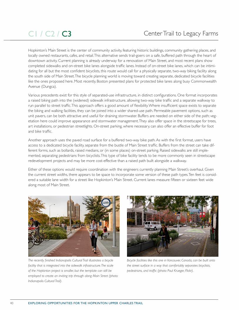
40 EXPLORING OPPORTUNITIES FOR THE HOPKINTON UPPER CHARLES TRAIL
Hopkinton’s Main Street is the center of community activity, featuring historic buildings, community gathering places, and locally owned restaurants, cafes, and retail. This alternative sends trail-goers on a safe, buffered path through the heart of downtown activity. Current planning is already underway for a renovation of Main Street, and most recent plans show completed sidewalks and on-street bike lanes alongside traffic lanes. Instead of on-street bike lanes, which can be intimi-dating for all but the most confident bicyclists, this route would call for a physically separate, two-way biking facility along the south side of Main Street. The bicycle planning world is moving toward creating separate, dedicated bicycle facilities like the ones proposed here. Most recently, Boston presented plans for protected bike lanes along busy Commonwealth Avenue (Dungca).
Various precedents exist for this style of separated-use infrastructure, in distinct configurations. One format incorporates a raised biking path into the (widened) sidewalk infrastructure, allowing two-way bike traffic and a separate walkway to run parallel to street traffic. This approach offers a good amount of flexibility. Where insufficient space exists to separate the biking and walking facilities, they can be joined into a wider shared-use path. Permeable pavement options, such as unit pavers, can be both attractive and useful for draining stormwater. Buffers are needed on either side of the path; veg-etation here could improve appearance and stormwater management. They also offer space in the streetscape for trees, art installations, or pedestrian streetlights. On-street parking, where necessary, can also offer an effective buffer for foot and bike traffic.
Another approach uses the paved road surface for a buffered two-way bike path. As with the first format, users have access to a dedicated bicycle facility, separate from the bustle of Main Street traffic. Buffers from the street can take dif-ferent forms, such as bollards, raised medians, or (in some places) on-street parking. Raised sidewalks are still imple-mented, separating pedestrians from bicyclists. This type of bike facility tends to be more commonly seen in streetscape redevelopment projects and may be more cost-effective than a raised path built alongside a walkway.
Either of these options would require coordination with the engineers currently planning Main Street’s overhaul. Given the current street widths, there appears to be space to incorporate some version of these path types. Ten feet is consid-ered a suitable lane width for a street like Hopkinton’s Main Street. Current lanes measure fifteen or sixteen feet wide along most of Main Street.
Center Trail to Legacy Farms
The recently finished Indianapolis Cultural Trail illustrates a bicycle
facility that is integrated into the sidewalk infrastructure. The scale
of the Hopkinton project is smaller, but the template can still be
employed to create an inviting trip through along Main Street (photo:
Indianapolis Cultural Trail).
Bicycle facilities like this one in Vancouver, Canada, can be built onto
the street surface in a way that comfortably separates bicyclists,
pedestrians, and traffic (photo: Paul Krueger, Flickr).
C1 / C2 / C3
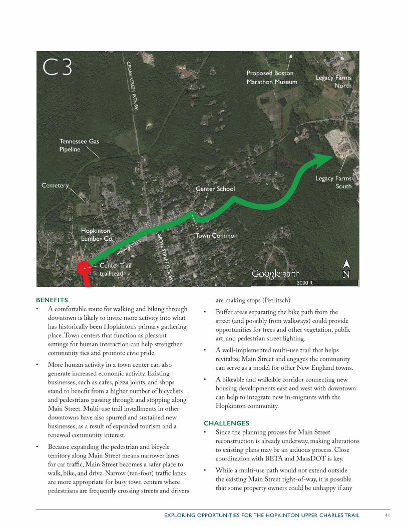
41EXPLORING OPPORTUNITIES FOR THE HOPKINTON UPPER CHARLES TRAIL
BENEFITS• A comfortable route for walking and biking through
downtown is likely to invite more activity into what has historically been Hopkinton’s primary gathering place. Town centers that function as pleasant settings for human interaction can help strengthen community ties and promote civic pride.
• More human activity in a town center can also generate increased economic activity. Existing businesses, such as cafes, pizza joints, and shops stand to benefit from a higher number of bicyclists and pedestrians passing through and stopping along Main Street. Multi-use trail installments in other downtowns have also spurred and sustained new businesses, as a result of expanded tourism and a renewed community interest.
• Because expanding the pedestrian and bicycle territory along Main Street means narrower lanes for car traffic, Main Street becomes a safer place to walk, bike, and drive. Narrow (ten-foot) traffic lanes are more appropriate for busy town centers where pedestrians are frequently crossing streets and drivers
are making stops (Petritsch).
• Buffer areas separating the bike path from the street (and possibly from walkways) could provide opportunities for trees and other vegetation, public art, and pedestrian street lighting.
• A well-implemented multi-use trail that helps revitalize Main Street and engages the community can serve as a model for other New England towns.
• A bikeable and walkable corridor connecting new housing developments east and west with downtown can help to integrate new in-migrants with the Hopkinton community.
CHALLENGES• Since the planning process for Main Street
reconstruction is already underway, making alterations to existing plans may be an arduous process. Close coordination with BETA and MassDOT is key.
• While a multi-use path would not extend outside the existing Main Street right-of-way, it is possible that some property owners could be unhappy if any
Legacy Farms South
Legacy Farms North
Tennessee Gas Pipeline
Hopkinton Lumber Co.
MAIN STREET
GRO
VE ST
REET
(RTE. 85)
CED
AR
STR
EET (RT
E. 85)Center Trail trailhead
Cemetery
Town Common
Center School
Proposed Boston Marathon Museum
C3
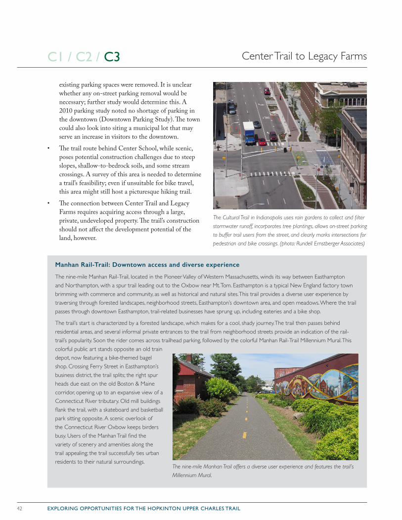
42 EXPLORING OPPORTUNITIES FOR THE HOPKINTON UPPER CHARLES TRAIL
existing parking spaces were removed. It is unclear whether any on-street parking removal would be necessary; further study would determine this. A 2010 parking study noted no shortage of parking in the downtown (Downtown Parking Study). The town could also look into siting a municipal lot that may serve an increase in visitors to the downtown.
• The trail route behind Center School, while scenic, poses potential construction challenges due to steep slopes, shallow-to-bedrock soils, and some stream crossings. A survey of this area is needed to determine a trail’s feasibility; even if unsuitable for bike travel, this area might still host a picturesque hiking trail.
• The connection between Center Trail and Legacy Farms requires acquiring access through a large, private, undeveloped property. The trail’s construction should not affect the development potential of the land, however.
Manhan Rail-Trail: Downtown access and diverse experience
The nine-mile Manhan Rail-Trail, located in the Pioneer Valley of Western Massachusetts, winds its way between Easthampton and Northampton, with a spur trail leading out to the Oxbow near Mt. Tom. Easthampton is a typical New England factory town brimming with commerce and community, as well as historical and natural sites. This trail provides a diverse user experience by traversing through forested landscapes, neighborhood streets, Easthampton’s downtown area, and open meadows. Where the trail passes through downtown Easthampton, trail-related businesses have sprung up, including eateries and a bike shop.
The trail’s start is characterized by a forested landscape, which makes for a cool, shady journey. The trail then passes behind residential areas, and several informal private entrances to the trail from neighborhood streets provide an indication of the rail-trail’s popularity. Soon the rider comes across trailhead parking, followed by the colorful Manhan Rail-Trail Millennium Mural. This colorful public art stands opposite an old train depot, now featuring a bike-themed bagel shop. Crossing Ferry Street in Easthampton’s business district, the trail splits; the right spur heads due east on the old Boston & Maine corridor, opening up to an expansive view of a Connecticut River tributary. Old mill buildings flank the trail, with a skateboard and basketball park sitting opposite. A scenic overlook of the Connecticut River Oxbow keeps birders busy. Users of the Manhan Trail find the variety of scenery and amenities along the trail appealing; the trail successfully ties urban residents to their natural surroundings.
The nine-mile Manhan Trail offers a diverse user experience and features the trail’s
Millennium Mural.
Center Trail to Legacy FarmsC1 / C2 / C3
The Cultural Trail in Indianapolis uses rain gardens to collect and filter
stormwater runoff, incorporates tree plantings, allows on-street parking
to buffer trail users from the street, and clearly marks intersections for
pedestrian and bike crossings. (photo: Rundell Ernstberger Associates)
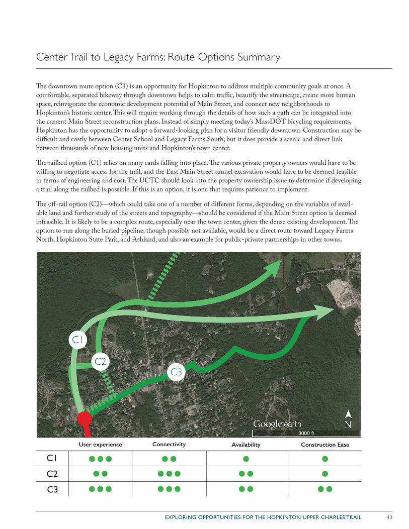
43EXPLORING OPPORTUNITIES FOR THE HOPKINTON UPPER CHARLES TRAIL
The downtown route option (C3) is an opportunity for Hopkinton to address multiple community goals at once. A comfortable, separated bikeway through downtown helps to calm traffic, beautify the streetscape, create more human space, reinvigorate the economic development potential of Main Street, and connect new neighborhoods to Hopkinton’s historic center. This will require working through the details of how such a path can be integrated into the current Main Street reconstruction plans. Instead of simply meeting today’s MassDOT bicycling requirements, Hopkinton has the opportunity to adopt a forward-looking plan for a visitor friendly downtown. Construction may be difficult and costly between Center School and Legacy Farms South, but it does provide a scenic and direct link between thousands of new housing units and Hopkinton’s town center.
The railbed option (C1) relies on many cards falling into place. The various private property owners would have to be willing to negotiate access for the trail, and the East Main Street tunnel excavation would have to be deemed feasible in terms of engineering and cost. The UCTC should look into the property ownership issue to determine if developing a trail along the railbed is possible. If this is an option, it is one that requires patience to implement.
The off-rail option (C2)—which could take one of a number of different forms, depending on the variables of avail-able land and further study of the streets and topography—should be considered if the Main Street option is deemed infeasible. It is likely to be a complex route, especially near the town center, given the dense existing development. The option to run along the buried pipeline, though possibly not available, would be a direct route toward Legacy Farms North, Hopkinton State Park, and Ashland, and also an example for public-private partnerships in other towns.
Center Trail to Legacy Farms: Route Options Summary
C1
C2
User experience Connectivity Availability Construction Ease
C3
C1
C2C3
44 EXPLORING OPPORTUNITIES FOR THE HOPKINTON UPPER CHARLES TRAIL
The final segment to plan for the Upper Charles Trail is the connection from the planned trail system within Legacy Farms to the Ashland border. Completing the trail segments discussed earlier in this section should take precedent over this final connection. The Ashland trail route has yet to be decided, and there is no specific trail to connect with.
The Ashland Upper Charles Trail Committee formed in 2014 to begin planning Ashland’s portion of the Upper Charles Trail, and the planning process remains in the early stages of development. Currently, Ashland’s UCTC is exploring multiple trail routes (ashlandbikeclub.com/upper-charles-trail-committee), which could provide two opportunities to connect to Hopkinton’s trails.
D1: The first opportunity is a connection with the Hop-kinton trail near the southeast edge of Hopkinton State Park. The old nursery roads in Legacy Farms North lead up to the Ashland town line, just over two hundred yards from the dam at the east end of Hopkinton Reservoir. Given Legacy Farms’ commitment to developing a multi-use trail network, this would be an ideal point of contact for the two trails. This intersection is less than
one and one-half miles from the commuter rail station in Ashland—less than ten minutes by bike. A successful connection between the two trails provides not only in-creased recreational opportunities for users of the Upper Charles Trail, but also safe access to the MBTA station.
D2: The second opportunity for the two towns to con-nect trails is in the southeast corner of Ashland State Park. One proposed spur off of the Ashland trail would wrap around the eastern side of Ashland Reservoir at Ashland State Park. This spur would come within one mile of the intersection of Clinton Street and the Hop-kinton town line. The developer of Legacy Farms has already agreed to develop the trail network to that point. From here, the connection could potentially make use of Olive and Spring Streets in Ashland to connect the two trails.
The value of either of these connections is largely depen-dent on Ashland’s development of its portion of the Upper Charles Trail. The D2 connection, in particular, relies on Ashland’s construction of a trail spur around the southern edge of Ashland Reservoir. The D2 connec-tion should be considered a low-priority development until further collaboration with Ashland is determined.
Legacy Farms to AshlandD1 / D2
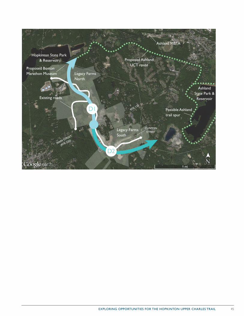
45EXPLORING OPPORTUNITIES FOR THE HOPKINTON UPPER CHARLES TRAIL
D2
D1
Proposed Ashland UCT route
Possible Ashland trail spur
Legacy Farms North
Legacy Farms South
MAIN STREET
(RTE. 135)
RTE. 135
Hopkinton State Park & Reservoir
CLINTON STREET
Ashland State Park & Reservoir
Ashland MBTA
Existing roads
Proposed Boston Marathon Museum
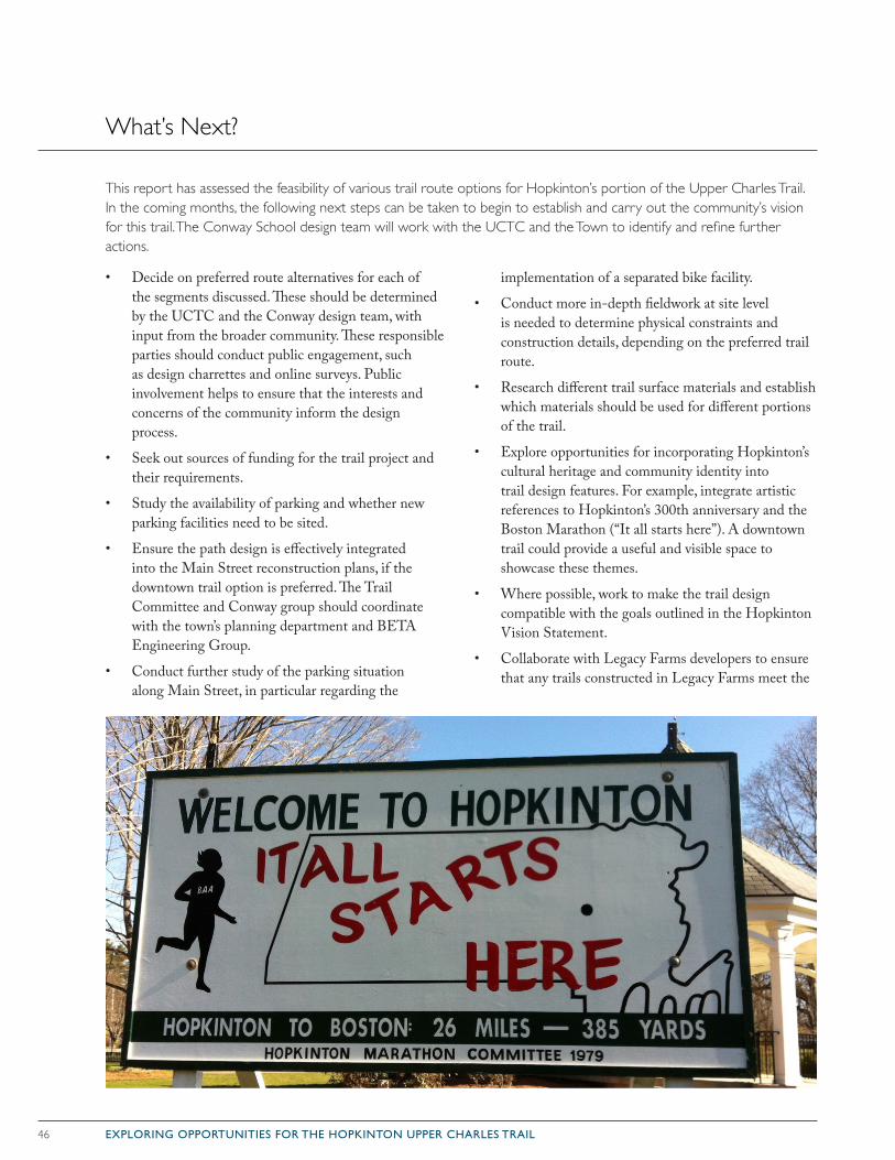
46 EXPLORING OPPORTUNITIES FOR THE HOPKINTON UPPER CHARLES TRAIL
What’s Next?
• Decide on preferred route alternatives for each of the segments discussed. These should be determined by the UCTC and the Conway design team, with input from the broader community. These responsible parties should conduct public engagement, such as design charrettes and online surveys. Public involvement helps to ensure that the interests and concerns of the community inform the design process.
• Seek out sources of funding for the trail project and their requirements.
• Study the availability of parking and whether new parking facilities need to be sited.
• Ensure the path design is effectively integrated into the Main Street reconstruction plans, if the downtown trail option is preferred. The Trail Committee and Conway group should coordinate with the town’s planning department and BETA Engineering Group.
• Conduct further study of the parking situation along Main Street, in particular regarding the
implementation of a separated bike facility.
• Conduct more in-depth fieldwork at site level is needed to determine physical constraints and construction details, depending on the preferred trail route.
• Research different trail surface materials and establish which materials should be used for different portions of the trail.
• Explore opportunities for incorporating Hopkinton’s cultural heritage and community identity into trail design features. For example, integrate artistic references to Hopkinton’s 300th anniversary and the Boston Marathon (“It all starts here”). A downtown trail could provide a useful and visible space to showcase these themes.
• Where possible, work to make the trail design compatible with the goals outlined in the Hopkinton Vision Statement.
• Collaborate with Legacy Farms developers to ensure that any trails constructed in Legacy Farms meet the
This report has assessed the feasibility of various trail route options for Hopkinton’s portion of the Upper Charles Trail. In the coming months, the following next steps can be taken to begin to establish and carry out the community’s vision for this trail. The Conway School design team will work with the UCTC and the Town to identify and refine further actions.
47EXPLORING OPPORTUNITIES FOR THE HOPKINTON UPPER CHARLES TRAIL
References
Abildso, C., Zizzi, S., Abildso, L., Steele, J., Gordon, P., Built Environment and Psychosocial Factors Associated with Trail Proximity and Use. Centers for Disease Control and Prevention and the West Virginia University Prevention Research Center. August 2007. web. March 2015.
Badger, Emily. “Cyclists and Pedestrians Can End Up Spending More Each Month Than Drivers.” The Atlantic: City Lab. December 5, 2012. web. March 2015.
Beneficial Designs, Inc. Designing Sidewalks and Trails for Access. Federal Highway Administration. July 1999. web. March 2015.
Build Trails. Rails-To-Trails Conservancy. n.d. web. March. 2015.
The Business Council of New York State, Inc. Greenways and Trails. Bringing Economic Benefits to New York. New York Parks and Conservation Associates. n.d. web. March 2015.
Della Penna, Craig. American Trails. National Trails Training Partnership. March 29, 2009. web. March 2015.
Downtown Revitalization Committee. Downtown Challenges and Recommendations. Hopkinton, Massachusetts Government. n.d. web. March 2015.
Downtown Revitalization Committee. Downtown Parking Study. Hopkinton, Massachusetts Government. n.d. web. March 2015.
Dungca, Nicole. “Boston to Install Protected Bike Lanes on Commonwealth Avenue.” The Boston Globe. March 24, 2015. web. March 2015.
Fuller, Dawn. “New Research Finds That Homeowners and City Planners Should ‘Hit the Trail’ When Considering Property Values.” University of Cincinnati. N.p., 10 Nov. 2011. Web. 16 Apr. 2015.
Hopkinton Master Plan Committee. Town of Hopkinton Master Plan 2007. Hopkinton Planning Board. January 22, 2007. web. March 2015.
Hopkinton Planning Board. 2013 Open Space and Recreation Plan. Hopkinton, Massachusetts Government. n.d. web. March 2015.
Jaffe, Eric. “The Complete Business Case for Converting Street Parking into Bike Lanes.” The Atlantic: City Lab. March 2015.
Kuradeniz, Duygu. The Impact of the Little Miami Scenic Trail on Single Family Residential Property Values. University of Cincinatti. 2008. web. March 2015.
Loheed. Pat. Hopkinton Center Trail Study. Town of Hopkinton Planning Board. September 1998. web. March 2015.
McMorrow, Paul. “Parklets a Lively Lure to Downtowns.” The Boston Globe. April 22, 2014. web. March 2015.
Morris, Hugh. From Trail Towns to TrOD: Trails and Economic Development. Rails-To-Trails Conservancy. August 2007. web. March 2015.
Phelps, Jonathan. “Hopkinton Planning Board Rejects Crossroads Plan.” The Metro West Daily News. March 24, 2015. web. March 2015.
Renski, Henry. “The Economic Impacts of the Restoration of Schell Bridge.” (n.d.): 30. Apr. 2011. Web.
Reynolds, Gretchen. “Easing Brain Fatigue With a Walk in the Park.” The New York Times. March 27, 2013. web. March 2015.
Town of Hopkinton Wetlands Protection Regulations. Hopkinton, Massachusetts Conservation Commission. Hopkinton, Massachusetts Government. February 11, 2013. web. March 2015.
Uniform Federal Accessibility Standards. United States Access Board. n.d. web. March 2015.
Woolsey, H., A. Finton, J. DeNormandie. 2010. BioMap2: Conserving the Biodiversity of Massachusetts in a Changing World. Massachusetts Department of Fish and Game/Natural Heritage and Endangered Species Program and The Nature Conservatory/Massachusetts Program.
48 EXPLORING OPPORTUNITIES FOR THE HOPKINTON UPPER CHARLES TRAIL
For the first phase of the Hopkinton Upper Charles Trail Master Plan, focused on the feasibility of a multi-use trail in Hopkinton, the Conway School team engaged with members of the Hopkinton Upper Charles Trail Committee as well as municipal stakeholders. In addition to an introductory meeting with the UCTC, and multiple informal tours of potential trail locations, the Conway School conducted two meetings to involve a broader group of stakeholders in the study of potential trail routes. The UCTC and Conway School have agreed to fully engage the public as the planning process con-tinues, so that the options for the Upper Charles Trail can be informed by public opinion.
The members of the Upper Charles Trail Committee are:
• Kenneth Parker, Chair
• Jeffrey Barnes
• John Coutinho
• Jane Moran
• Dave O’Brien
• Mike Resteghini
• Barry Rosenbloom
• Bob Snyder
• Eric Sonnett
• Gary Trendel
Municipal stakeholders participated in the first two planning meetings on February 12, and March 5, 2015. In addition to providing feedback regarding, places of interest, town concerns, and the benefits and challenges of specific routes, many of these representatives spoke with the Conway School team to provide specific input based on their realm of expertise. The following people were contacted for their input in this process:
• Amy Beck, Assistant Director, Senior Center
• Cindy Chesmore, Director, Senior Center
• Jeffrey Doherty, Chairman, Open Space Preservation Committee
• Kenny Clark, Chief, Fire Department
• John Graziano, Chair, School Committee
• Kelly Grill, Executive Director, Center for the Arts
• Norman Khumalo, Town Manager
• Tim Kilduff, Executive Director, 26-2 Foundation
• Elaine Lazarus, Director, Planning, Land Use and Permitting
• Ed Lee, Chief, Police Department
• Don MacAdam, Conservation Administrator, Conservation Commission
• Scott Richardson, President, Chamber of Commerce
• Charles Wallace, Lieutenant Police Department
• Robert Weidknecht, Chairman, Holliston Rail Trail Committee
• Ken Weismantel, Hopkinton Planning Board
• John Westerling, Department of Public Works
• Margie Wiggin, Chair, Youth Commission
Appendix A: Stakeholder involvement
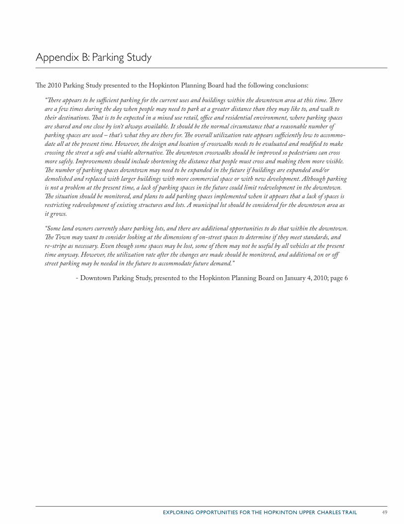
49EXPLORING OPPORTUNITIES FOR THE HOPKINTON UPPER CHARLES TRAIL
Appendix B: Parking Study
The 2010 Parking Study presented to the Hopkinton Planning Board had the following conclusions:
“There appears to be sufficient parking for the current uses and buildings within the downtown area at this time. There are a few times during the day when people may need to park at a greater distance than they may like to, and walk to their destinations. That is to be expected in a mixed use retail, office and residential environment, where parking spaces are shared and one close by isn’t always available. It should be the normal circumstance that a reasonable number of parking spaces are used – that’s what they are there for. The overall utilization rate appears sufficiently low to accommo-date all at the present time. However, the design and location of crosswalks needs to be evaluated and modified to make crossing the street a safe and viable alternative. The downtown crosswalks should be improved so pedestrians can cross more safely. Improvements should include shortening the distance that people must cross and making them more visible. The number of parking spaces downtown may need to be expanded in the future if buildings are expanded and/or demolished and replaced with larger buildings with more commercial space or with new development. Although parking is not a problem at the present time, a lack of parking spaces in the future could limit redevelopment in the downtown. The situation should be monitored, and plans to add parking spaces implemented when it appears that a lack of spaces is restricting redevelopment of existing structures and lots. A municipal lot should be considered for the downtown area as it grows.
“Some land owners currently share parking lots, and there are additional opportunities to do that within the downtown. The Town may want to consider looking at the dimensions of on-street spaces to determine if they meet standards, and re-stripe as necessary. Even though some spaces may be lost, some of them may not be useful by all vehicles at the present time anyway. However, the utilization rate after the changes are made should be monitored, and additional on or off street parking may be needed in the future to accommodate future demand.”
- Downtown Parking Study, presented to the Hopkinton Planning Board on January 4, 2010; page 6
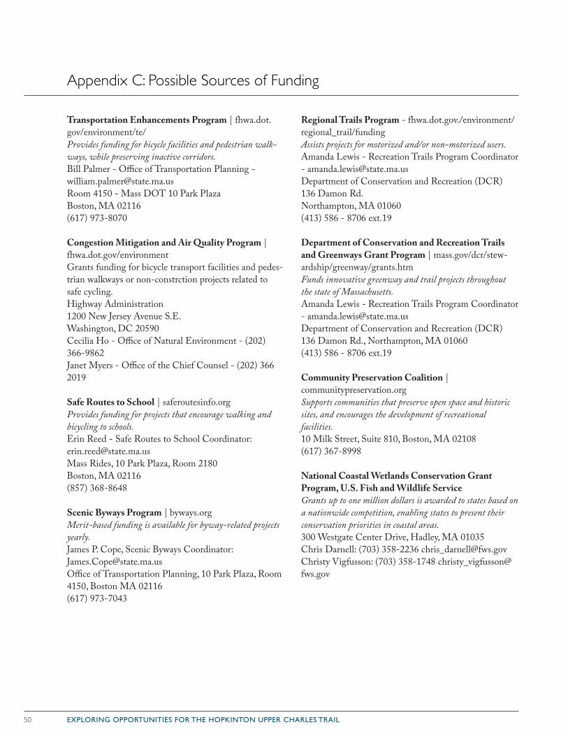
50 EXPLORING OPPORTUNITIES FOR THE HOPKINTON UPPER CHARLES TRAIL
Transportation Enhancements Program | fhwa.dot.gov/environment/te/Provides funding for bicycle facilities and pedestrian walk-ways, while preserving inactive corridors.Bill Palmer - Office of Transportation Planning - [email protected] 4150 - Mass DOT 10 Park PlazaBoston, MA 02116(617) 973-8070
Congestion Mitigation and Air Quality Program | fhwa.dot.gov/environmentGrants funding for bicycle transport facilities and pedes-trian walkways or non-constrction projects related to safe cycling.Highway Administration1200 New Jersey Avenue S.E.Washington, DC 20590Cecilia Ho - Office of Natural Environment - (202) 366-9862Janet Myers - Office of the Chief Counsel - (202) 366 2019
Safe Routes to School | saferoutesinfo.orgProvides funding for projects that encourage walking and bicycling to schools.Erin Reed - Safe Routes to School Coordinator: [email protected] Rides, 10 Park Plaza, Room 2180Boston, MA 02116(857) 368-8648
Scenic Byways Program | byways.orgMerit-based funding is available for byway-related projects yearly.James P. Cope, Scenic Byways Coordinator: [email protected] of Transportation Planning, 10 Park Plaza, Room 4150, Boston MA 02116(617) 973-7043
Regional Trails Program - fhwa.dot.gov./environment/regional_trail/fundingAssists projects for motorized and/or non-motorized users.Amanda Lewis - Recreation Trails Program Coordinator - [email protected] of Conservation and Recreation (DCR)136 Damon Rd.Northampton, MA 01060(413) 586 - 8706 ext.19
Department of Conservation and Recreation Trails and Greenways Grant Program | mass.gov/dcr/stew-ardship/greenway/grants.htmFunds innovative greenway and trail projects throughout the state of Massachusetts.Amanda Lewis - Recreation Trails Program Coordinator - [email protected] of Conservation and Recreation (DCR)136 Damon Rd., Northampton, MA 01060(413) 586 - 8706 ext.19
Community Preservation Coalition | communitypreservation.orgSupports communities that preserve open space and historic sites, and encourages the development of recreational facilities.10 Milk Street, Suite 810, Boston, MA 02108(617) 367-8998
National Coastal Wetlands Conservation Grant Program, U.S. Fish and Wildlife ServiceGrants up to one million dollars is awarded to states based on a nationwide competition, enabling states to present their conservation priorities in coastal areas.300 Westgate Center Drive, Hadley, MA 01035Chris Darnell: (703) 358-2236 [email protected] Vigfusson: (703) 358-1748 [email protected]
Appendix C: Possible Sources of Funding
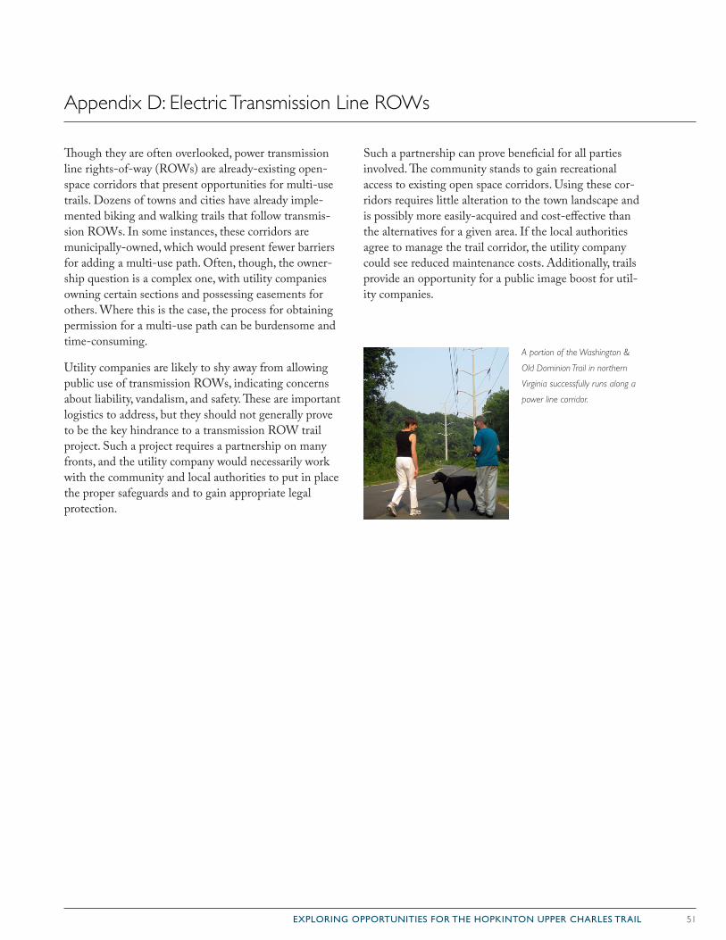
51EXPLORING OPPORTUNITIES FOR THE HOPKINTON UPPER CHARLES TRAIL
Though they are often overlooked, power transmission line rights-of-way (ROWs) are already-existing open-space corridors that present opportunities for multi-use trails. Dozens of towns and cities have already imple-mented biking and walking trails that follow transmis-sion ROWs. In some instances, these corridors are municipally-owned, which would present fewer barriers for adding a multi-use path. Often, though, the owner-ship question is a complex one, with utility companies owning certain sections and possessing easements for others. Where this is the case, the process for obtaining permission for a multi-use path can be burdensome and time-consuming.
Utility companies are likely to shy away from allowing public use of transmission ROWs, indicating concerns about liability, vandalism, and safety. These are important logistics to address, but they should not generally prove to be the key hindrance to a transmission ROW trail project. Such a project requires a partnership on many fronts, and the utility company would necessarily work with the community and local authorities to put in place the proper safeguards and to gain appropriate legal protection.
Such a partnership can prove beneficial for all parties involved. The community stands to gain recreational access to existing open space corridors. Using these cor-ridors requires little alteration to the town landscape and is possibly more easily-acquired and cost-effective than the alternatives for a given area. If the local authorities agree to manage the trail corridor, the utility company could see reduced maintenance costs. Additionally, trails provide an opportunity for a public image boost for util-ity companies.
A portion of the Washington &
Old Dominion Trail in northern
Virginia successfully runs along a
power line corridor.
Appendix D: Electric Transmission Line ROWs