uav-based ground penetrating synthetic aperture radar
TRANSCRIPT

UAV-Based Ground Penetrating Synthetic Aperture Radar
Markus Schartel, Ralf Burr, Winfried Mayer, Nando Docci, and Christian Waldschmidt
c© 2018 IEEE. Personal use of this material is permitted. Permission from IEEE must be obtained for all other uses, in anycurrent or future media, including reprinting/republishing this material for advertising or promotional purposes, creatingnew collective works, for resale or redistribution to servers or lists, or reuse of any copyrighted component of this work in
other works.
DOI: 10.1109/ICMIM.2018.8443503
UAV-Based Ground PenetratingSynthetic Aperture Radar
Markus Schartel∗, Ralf Burr†, Winfried Mayer‡, Nando Docci§, and Christian Waldschmidt∗∗Institute of Microwave Engineering, Ulm University, 89081 Ulm, Germany
†Ulm University of Applied Sciences, 89075 Ulm, Germany‡Endress+Hauser GmbH+Co. KG, 79689 Maulburg, Germany
§University of Applied Sciences and Arts Northwestern SwitzerlandEmail: [email protected]
Abstract—A novel approach for anti-personnel landmine de-tection using an unmanned aerial vehicle (UAV) in combinationwith a ground penetrating synthetic aperture radar (GPSAR) ispresented. The objective of the system is to accelerate the processof land release in humanitarian demining. Suspicious objects shallbe detected by the radar and marked for further investigationsusing different sensor principles.
The ground penetrating radar (GPR) module consists of a1 GHz to 4 GHz side-looking frequency modulated continuouswave (FMCW) radar, a radar and lidar altimeter, and a realtime kinematic global navigation satellite system (RTK GNSS).The image processing is done offline using a back-projectionalgorithm. In the theoretical part of this paper the systempartitioning, the sensor module, and the position accuracyrequirements are briefly described. In the experimental part ofthis paper synthetic aperture radar (SAR) measurements arepresented.
I. INTRODUCTION
Anti-personnel landmines are often used in conflicts toprevent the advance of the enemy or to block humanitarianaccess [1]. After the hostilities, mines are a hidden andpermanent threat to the returning civilians and can injure andkill people still decades later. In 2015, the landmine monitor[2] recorded 6.461 mine or ERM (explosive remnants of war)casualties.
For more than 20 years ground penetrating radars havebeen used to detect buried objects [1]. In comparison to metaldetectors the detection capabilities of radars are not limitedto metal objects only. GPRs are a promising approach todetect modern minimum metal mines. Presently, most GPRsensors for mine detection used in humanitarian demining arehandheld devices which operate very close to the surface.
To accelerate the process of land release, the focus is on thetechnical survey. Different sensor modules shall be mountedon a low-altitude flying UAV to detect hazard-free the presenceand approximate location of anti-personnel landmines.
In this paper the fundamental system concept with respect toa sensor module consisting of a ground penetrating syntheticaperture radar is presented. The task of the GPSAR is to locateand mark suspicious objects for further investigations.
The paper is organized as follows: Section II briefly de-scribes the system partitioning. The GPSAR module is pre-sented in Section III. In Section IV first SAR measurementsare discussed, and Section V gives a short conclusion.
II. SYSTEM PARTITIONING
For a reliable mine detection it is beneficial to use differentsensor principles. Since the payload of a UAV is limited, theoverall system is separated into a carrier platform and inde-pendently operating sensor modules. Each of these modulesuses a different sensor principle, e.g. radar, metal detector, in-frared/hyperspectral methods, or biological/chemical methods.Depending on the application and the ambient conditions thecarrier platform and/or the sensor module can be exchanged.
Since each sensor principle has its specific demands regard-ing flight planning, the carrier platform needs to be a rotarywing aircraft such as a helicopter or multicopter. Thus, thecarrier platform can follow a trajectory or hover over certainspots.
III. THE GPSAR SENSOR MODULE
The penetration depth of electromagnetic waves dependson the frequency and the dielectric properties [1]. In [3], [4]a frequency range from 0.5 GHz to 5 GHz is proposed for thedetection of anti-personnel landmines up to a depth of 20 cm.As a compromise between penetration depth, resolution, andgeometrical dimensions suitable for UAV applications, a fre-quency range of 1 GHz to 4 GHz was selected.
The radar prototype is a single-input single-output (SISO)FMCW radar system in a bistatic configuration. A voltagecontrolled oscillator generates a linear frequency ramp from1 GHz to 2 GHz. This ramp can be doubled by a frequencymultiplier resulting in a second ramp from 2 GHz to 4 GHz.These two separate ramps are later joined in the signalprocessing step.
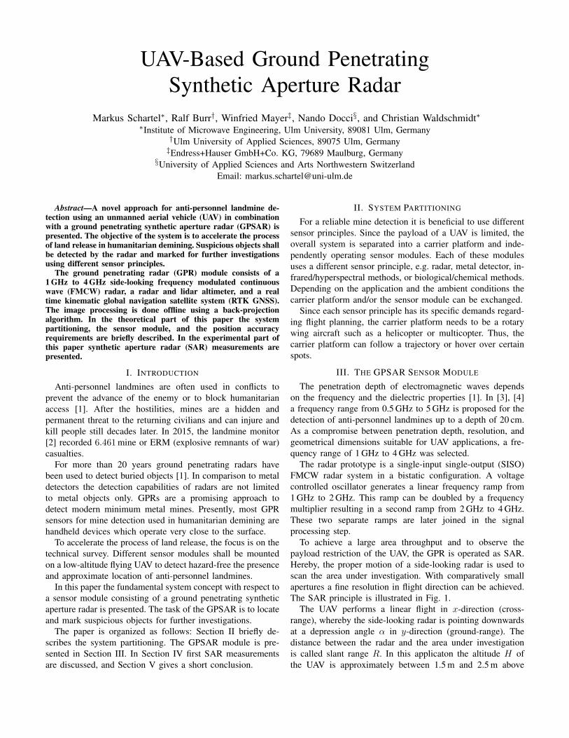
To achieve a large area throughput and to observe thepayload restriction of the UAV, the GPR is operated as SAR.Hereby, the proper motion of a side-looking radar is used toscan the area under investigation. With comparatively smallapertures a fine resolution in flight direction can be achieved.The SAR principle is illustrated in Fig. 1.
The UAV performs a linear flight in x-direction (cross-range), whereby the side-looking radar is pointing downwardsat a depression angle α in y-direction (ground-range). Thedistance between the radar and the area under investigationis called slant range R. In this applicaton the altitude H ofthe UAV is approximately between 1.5 m and 2.5 m above

Cross-Range
Ground-Range
Altitude
Flight
Path
y
z
Swath Width
LSAR
x
v α
H
UAV
R
Near Ran
ge
Far Ran
geFig. 1. Illustration of the stripmap SAR geometry.
ground. According to the antenna theory the distance betweenthe measurements ∆x should not exceed λ0
2 to avoid gratinglobes, where λ0 is the free-space wavelength. The resolutionin ground-range δgr is determined by the bandwidth B, thedepression angle α, and the beam width of the antenna inelevation θe [5]:
δgr =c0
2B cos (α± θe2 )
, (1)
where c0 is the speed of light. Assuming a beam width θe= 40◦
and a depression angle α= 45◦, the ground-range resolution isbetween 10 cm in the near and 5.5 cm in the far range. Theusable swath width is approximately 2.5 m.
Due to the low flight altitude the resolution in cross-rangeδcr depends on the slant range R [6]:
δcr =λ04
√1 +
4R2
LSAR2 , (2)
where LSAR is the length of the synthetic aperture. Theresolution in cross-range is between 8 cm in the near rangeand 11 cm in the far range.
The SAR processor has to handle low-frequency ultrawideband (UWB) FMCW radar data obtained from a non-linear flight path in the near and far field of a wide-beamwidthantenna. Regarding frequency domain and time domain algo-rithms, back-projection may be the most suitable algorithm tofulfil all the demands at the expense of computing time [7]–[9]. The major advantages of this algorithm are the high imagequality and the integrated motion compensation.
The challenge of this approach is to obtain a good 3Dposition accuracy of the phase center of the antenna. Thegreen dashed curve (b) in Fig. 2 shows a sinusoidal deviationin y-direction from the ideal flight path (red solid (a)) withan amplitude of ±50 mm. This deviation is known. Theblue dotted curve (c) shows an unknown normally distributeddeviation of the ideal flight path with an amplitude of ±10 mm.The corresponding radar data and the processed SAR imagesare shown in Fig. 3. As long as the motion of the UAV is pre-cisely known, the back-projection algorithm can compensate
0 2 4 6 8
−40
−200
20
40
x in m
∆y
inm
m (a)(b)(c)
Fig. 2. Simulation of different flight paths of the UAV. (a) Ideal, (b) sinusoidal,known deviation, and (c) normally distributed, unknown deviation.
(a) (b) (c)
Fig. 3. Range compressed radar (upper row) and processed SAR image(lower row) for (a) ideal, (b) sinusoidal, known deviation, and (c) normallydistributed, unknown deviation according to Fig. 2.
deviations of the ideal flight path. However, unknown positionerrors in the range of ±10 mm influence the image quality.
The GPSAR module is shown in Fig. 4. It consists ofthe bistatic GPR equipped with lightweight 3D-printed hornantennas, a radar and a lidar altimeter, and a data logger. Themodule including a battery weights 1.6 kg and is mountedbelow the UAV.
IV. UAV-BASED SAR MEASUREMENTS
The measurement system is shown in Fig. 6. As carrierplatform a commercial available multicopter [10] was used.The selected UAV is factory fitted with 3 global satellitesystems (GPS) and 3 inertial measurement units (IMUs).Additionally, for highly accurate localization the multicopter
Radar / Lidar Altimeter Data Logger
GPSAR
Fig. 4. Photo of the GPSAR sensor module consisting of a bistatic 1 GHz to4 GHz FMCW radar, a 26 GHz radar and lidar altimeter, and a data logger.

Cross-Range
Slan
tR
ange
Fig. 5. Photo of the measurement setup from the perspective of the radar. The setup consists of 8 reflectors with an RCS σ1=−12.2 dBsm (red), 1 reflectorwith an RCS σ2=−15.3 dBsm pointing upwards (green), 2 corner reflectors with an RCS σ3= 3.7 dBsm (black), 3 metal cans (blue), and 4 plastic boxes(yellow). All targets have been placed on the ground.
was equipped with an RTK GNSS [11]. The RTK-GNSS dataas well as the entire telemetry data of the UAV flight controllercan be accessed via USB and is recorded by the data logger.
Despite the fact that state-of-the-art RTK-GNSS receiverspromise centimeter-level accuracy, these receivers usually pro-vide position data (3 degrees of freedom) only, but not theorientation. Thus, to extrapolate the exact position of the radarantenna at the time of each radar measurement, the RTK-GNSS data was interpolated and has been offset with thefiltered rotation data of the UAV flight controller. The dataflow is illustrated in Fig. 7.
As proof of concept a stripmap SAR measurement wasperformed. Hereby the UAV was manually flown in an altitudeof approximately 2.7 m parallel to the measurement setupshown in Fig. 5. As targets different sized corner reflectors,metal cans, and plastic boxes filled with beeswax have beenused. All targets have been placed on the ground.
The corresponding range compressed radar data (2 GHzto 4 GHz) is shown in Fig. 8. The free space loss is notcompensated. A small crosstalk between the horn antennasup to a range of 2 m can be observed. The first reflectionsfrom the ground are in a range of approximately 2.7 m. Thetransition between free space and the first ground reflectioncan be used to determine the flight altitude.
The hyperbolas with vertices at (# 150 / 3.8 m) and(# 400 / 3.8 m) are the reflections of the corner reflectors withan RCS σ3= 3.7 dBsm (black circled), marking the left andright edge of the measuring field. The hyperbolas of the plastic
Fig. 6. Photo of the measurement system. It consists of a DJI Matrice 600Pro, a DJI D-RTK GNSS mounted on the top of the UAV, and the GPSARsensor module mounted below the UAV.
GNSS Position
Rotation
PositionAntenna
SAR
Data
Quaternions
Dimensions
TerrainProfile
Radar
Sync
Radar
Translation/
UAV
Image
50 Hz
5 Hz 50 Hz
50 Hz
38 Hz
50 Hz 38 Hz
Fig. 7. Block diagram to illustrate the data flow of the processing toolchain.
100 200 300 400 5000
2
4
6
8
10
# Measurement
Slan
tR
ange
(m)
−40
−30
−20
−10
0
dB
Fig. 8. Range compressed radar data (2 GHz to 4 GHz).
boxes and the metal cans are not visible.Due to accelerations of the manually steered UAV, the
velocity during the stripmap SAR measurement is not constant.Since the chirp repetition frequency of the radar is fixed, theswath is not sampled equidistantly. Fulfilling the samplingtheorem, the back-projection algorithm could process the data.However, areas which are illuminated a longer period of timewould be weighted more, resulting in a misrepresentationof the signal strength. To compensate for this effect theradar data is weighted by the distance traversed between two

4 6 8 10 122
4
6
8
Cross-Range (m)
Gro
und-
Ran
ge(m
)
−40
−30
−20
−10
0
dB
(a) GPS fused data as input data.
4 6 8 10 122
4
6
8
Cross-Range (m)
Gro
und-
Ran
ge(m
)
−40
−30
−20
−10
0
dB
(b) RTK-GNSS data as input data.
4 5 6 73
4
5
6
7
Cross-Range (m)
Gro
und-
Ran
ge(m
)
−30
−28
−26
−24
−22
−20
dB
(c) Section of the image shown in Fig. 9b with adjusted dynamics.
Fig. 9. Measurement results.
measurements.The processed SAR images for 2 different position input
datasets are shown in Fig. 9. Therefore, the terrain wasmodelled as plane surface.
The result in Fig. 9a shows, that the position accuracy ofthe GPS fused data is not sufficient. The target response isblurred in cross-range direction. In addition, the location ofthe black circled reflectors is shifted in comparison to Fig. 9b.
If the high-precision RTK-GNSS data is used, all thereflectors can be focused very well. Even the plastic boxescan be mapped as shown in the image section in Fig. 9c. The
8th red circled reflector cannot be displayed in these imagesbecause it is located at a ground range distance of less than2 m.
To increase the ability to detect weak targets like plasticboxes, the position-dependent clutter needs to be suppressede.g. by using a multiple-input multiple-output (MIMO) system[12] or by superposition of images of the same scenariorecorded from different viewing angles gathered by a SISOsystem.
V. CONCLUSION
A ground penetrating synthetic aperture radar system forUAV-based mine detection has been presented. The systemconsists of a 1−4 GHz UWB FMCW radar, lightweight hornantennas, a radar and lidar altimeter, a data logger, an RTKGNSS, and a consumer UAV. The measurement results suc-cessfully proof the functionality of the system and showthat the position accuracy of an RTK GNSS is sufficient for1−4 GHz stripmap SAR.
VI. ACKNOWLEDGEMENT
The authors would like to thank the Urs Endress foundationfor their support and the collaboration.
REFERENCES
[1] Daniels D. J., ”Ground Penetrating Radar”, 2nd Edition, Institution ofElectrical Engineers, 2004.
[2] International Campaign to Ban Landmines, ”Landmine Monitor 2016”,Monitoring and Research Committee, ICBL-CMC Governance Board,November 2016.
[3] Fischer C. and Wiesbeck W., ”Multistatic GPR for antipersonnel minedetection,”, IGARSS, Sydney, 2001.
[4] Fritzsche, M., ”Anwendungen von Verfahren der Mustererkennung zurDetektion von Landminen mit Georadaren”, Dissertation, University ofKarlsruhe, 2001.
[5] Klausing, H. and Holpp, W., ”Radar mit realer und synthetischer Apertur:Konzeption und Realisierung”, Oldenburg, 2000.
[6] Schreiber E., Peichl M., Dill S., Anger S., Heinzel A., Bischeltsrieder F.,Kempf T., and Jirousek M., ”Theoretical and experimental investigationsof a ground-based high-resolution SAR for buried object detection,”European Radar Conference (EuRAD), Paris, 2015.
[7] Peichl M., Schreiber E., Heinzel A., and Kempf T., ”TIRAMI-SAR –a synthetic aperture radar approach for efficient detection of landminesand UXO”, Proc. of EUSAR – 10th European Conference of SyntheticAperture Radar, March 2014.
[8] Zaugg E. C. and Long D. G., ”Generalized Frequency Scaling andBackprojection for LFM-CW SAR Processing”, IEEE Trans. Geoscienceand Remote Sensing, July 2015
[9] Vu V. T., Sjogren T. K., and Pettersson M. I., ”A Comparison betweenFast Factorized Backprojection and Frequency-Domain Algorithms inUWB Lowfrequency SAR”, IGARSS IEEE International Geoscience andRemote Sensing Symposium, Boston, pp. 1284-1287, 2008.
[10] DJI, ”Matrice 600 Pro User Manual v1.0”, 2017.[11] DJI, ”DJI D-RTK Release Notes ”, 2017.[12] Schreiber E., Peichl M., Dill S., and Bischeltsrieder F., ”Detection of
landmines and UXO using advanced synthetic aperture radar technology”,Proc. SPIE 9823, Detection and Sensing of Mines, Explosive Objects, andObscured Targets XXI, May 2016.