tutorial for the geophysics information system with
TRANSCRIPT

Geophysics Information System
Tutorial for the Geophysics Information Systemwith application examples
https://www.fis-geophysik.de

Geophysics Information System
• The Geophysics Information System (FIS-GP) contains geophysical measurements and evaluations primarily for the territory of Germany. In addition to data by LIAG, FIS-GP contains data from other partner institutions.
• The architecture of the overall system is built up by a homogeneous structured database and its subdivision into a parent part (superstructure) and several method specific subsystems.
• FIS-GP is also available to the public (particular to partner institutions) via an internet interface.
• It is intended to build up a comprehensive database covering all of Germany (e.g. underground temperatures) by including data owned by other institutions and make it available.
Introduction

Geophysics Information System
System architecture
Local user
Capture/Maintenance
SearchProcessing/Evaluation
Print/ Visualization
Download
Search/Navigation
Download
Access co
ntro
l
Evaluation
Print/Visualization
FIS-GP-Search
FIS-GP-Viewer
Internet
Desktop access for certain subsystems
Desktop application
Database
Internet user
Primarily tables
Method specific tables
Rights administration

Geophysics Information System
• FIS-GP-Viewer allows geographic search and display of measurements and boreholes. FIS-GP-Viewer is based primarily on MapServer.
• FIS-GP-Search provides an attribute-oriented search via search forms and other functions (download, print, diagrams, maps, statistics, gridding, interpretation).
The next slide shows the start page…
Internet interface (FIS-GP-Search and FIS-GP-Viewer)
To access FIS-GP via the internet, LIAG developed two interconnected user interfaces on the basis of open source tools. For the use a browser is needed.

Geophysics Information System

Geophysics Information System
User-Login
The next slide shows the login page of FIS-GP. The authentication is done by entering user name and password, secured by https-protocol.
A guest account with restricted rights for datas is available for public access.

Geophysics Information System

Geophysics Information System
Setting up a user account
The next slide shows the registration of a FIS-GP user. The assignment of rights depends on the affiliation with a certain institution. Additional rights can be requested.
The transmission of login name and password takes place automatically via https or e-mail.

Geophysics Information System

Geophysics Information System
Information page
On the next slide you will see the information page of FIS-GP.
Via the menu bar you can select a subsystem and a searchable object-type (measurement, measuring device, evaluation, …). In addition, you can start the map application and see more information.
The two sections under the menu bar serve for the input of search conditions and for displaying results.

Geophysics Information System

Geophysics Information System
Display user rights
The menu item Show Account displays the user account and the role with all properties of the registered user.
In the lower section you find a Access Control List. Every search result set is compared according to the list.
In the case shown on the next slide, the user has unrestricted access to all data, which belong to the BGR, the LBEG (formerly NLfB) and the LIAG (formerly GGA).

Geophysics Information System

Geophysics Information System
Presentation of FIS-GP-Search on several examples:
Input of search conditions:
The menu item temperatures shows the searchable object types of this subsystem.
A mouse click on the submenu item boreholes opens a form in which search conditions for boreholes with temperature measurements can be defined.
The following slide shows a search for all temperature boreholes in Lower Saxony with a final depth <= 5000 m.

Geophysics Information System

Geophysics Information System

Geophysics Information System
Display of the set of hits
A mouse click on the button search starts the search.
All temperature boreholes in the database matching the search conditions are displayed in the set of hits in the lower section.
The menu item Start action above the set of hits shows the applicable evaluation and interpretation options.
The menu item Export/free format is selected in the following slide.

Geophysics Information System

Geophysics Information System
Export a set of hits to a download file
On the next slide you will see the column selection and the format options for the query and the display of the export statistics.
A mouse click on the hyperlink download zipfile opens or downloads the file.

Geophysics Information System

Geophysics Information System
Visualization a set of hits as a map
On the next slides you will see a search in the subsystem gravimetry (selection of all measuring points in the district Hanover) and the visualization of the set of hits using the software GMT (Generic Mapping Tools).
The z-field for the visualization of a xyz map is selectable in the base settings. The absolute gravity is used here.

Geophysics Information System

Geophysics Information System

Geophysics Information System

Geophysics Information System
Displaying protected database objects
Sensitive data are hidden if a user has not the access right to a database object.
Information on a single hit are shown after clicking on its ID in the set of hits. In particular the user can retrieve contact information of the data owner via the button show contact information, in order to clarify the conditions of use.
Therefore, FIS Geophysics acts as a geophysical data management system.

Geophysics Information System

Geophysics Information System
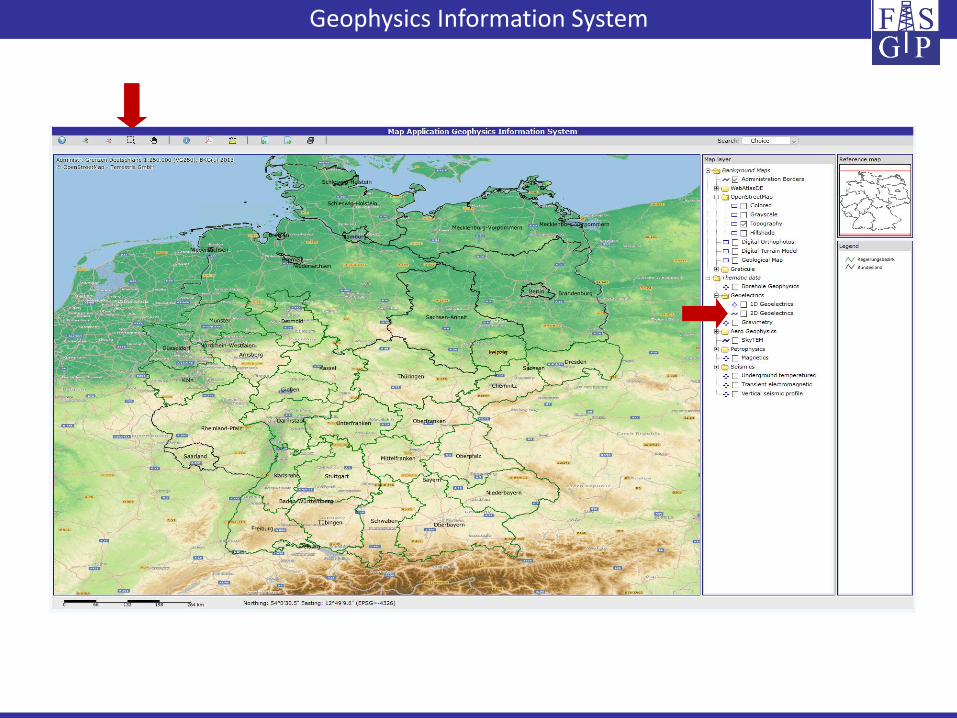
Presentation of FIS-GP-Viewer
Geophysical search for data
• the start page of FIS-GP-Viewer with a map view, a menu bar and a selecting for background and subsystem-layers;
• the result of a selection of the subsystems 1D geoelectric and gravimetry (supplemented by a topographical background) and the navigation to the island Spiekeroog.
FIS-GP-Viewer is an application of the MapServer configured for FIS Geophysics and allows the geographical search for georeferenced content (e.g. measurements).
On the next slides you will see:
Geophysics Information System

Geophysics Information System

Geophysics Information System
Selection, display and download of search results
Content of the next three slides:
1) Database objects can be selected and displayed as a set of hits via the button Show object(s) information.
2) Detailed information of a single hit can be shown by clicking the Object ID. If you like to download measurement data you have to choose an individual Subsystem from the drop-down menu and click the button Export hit objects.
3) To start the download press the button Start action.

Geophysics Information System

Geophysics Information System

Geophysics Information System
Navigation with FIS-GP-Viewer in the official municipal directory
A searchable offical municipal directory of Germany is integrated in FIS-GP-Viewer. A mouse click on an item of the action results centersthe map window on the chosen municipality.
A similar search option exists for the list of the TK25-planetable sheets of Germany.

Geophysics Information System

Geophysics Information System
Thank you for your interest!