turneffe atoll coastal zone management guidelines · 5. melanie mcfield, phd/roberto pott healthy...
TRANSCRIPT
Turneffe Atoll Coastal Zone Management Guidelines Belize Integrated Coastal Zone Management Plan Coastal Zone Management Authority & Institute 2015 Page | 1
Cite as: Coastal Zone Management Authority and Institute (CZMAI). 2015. Turneffe Atol Coastal Zone Management Guidelines. Belize Integrated Coastal Zone Management Plan. CZMAI, Belize City.
The reproduction of this publication for educational and sourcing purposes is authorized, with the recognition of intellectual property rights of the authors. Reproduction for commercial purposes is prohibited without the prior written permission of the copyright holder. © Belize Coastal Zone Management Authority and Institute All Rights Reserved
Turneffe Atoll Coastal Zone Management Guidelines Belize Integrated Coastal Zone Management Plan Coastal Zone Management Authority & Institute 2015 Page | 2
ACKNOWLEDGEMENTS
The Belize Coastal Zone Management Authority and Institute (CZMAI) extends its
sincere gratitude to all those individuals and organizations who participated in the development
of the Turneffe Atoll Coastal Zone Management Guidelines. The process began in the early
1990’s with the Turneffe Islands Committee (TIC), which was established to help protect the
atoll’s fragile environment and the rights of customary users, the commercial fishermen. The
Turneffe Islands Committee intended to allot parts of the atoll for different uses; however, this
process was never initiated and TIC ceased to exist in 1992.
In 1994, the need for effective management and protection of Turneffe was emphasized
by the three ministries principally responsible for Belize’s coastal zone: The Ministries of
Agriculture and Fisheries, Environment and Tourism. In 1996, John Gill et al drafted the
Turneffe Islands Development Guidelines (TIDG) with the aim of achieving sustainable
development of the atoll. This process evolved through an extensive study of the region, and
consultation with the following stakeholders:
1. Richards, Gilbert 1994 Frame Survey Report (Fisheries Department)
2. Zisman, S; Minty, C; Murray, M 1995 Turneffe Terrestrial Resource Reconnaissance:
Report to CCC Ltd, Department of Geography, University of Edinburgh
3. Turneffe Island Committee (courtesy Earl Young, Coastal Zone Management Unit,
Fisheries Department., and Clinton Gardiner,
4. DCLS, Lands & Surveys Dept.
5. Ray Lightburn, Blackbird Caye Resort, Turneffe Islands
6. Jonathan Ridley, Marjo Vierros, and Kevin Coye; Coral Caye Conservation
7. Gayle Bradley Miller, Marine Research Centre, University College of Belize
8. Susan Wells, Coastal Zone Management Project
9. Carmen Cawich, Coastal Zone Management Project
10. Rory Solis, Coastal Zone Management Project
11. Turneffe Island Lodge, Turneffe Islands
12. Hopeton Westby, Fisherman
13. Morrel Young, Fisherman
14. Amigos del Mar, San Pedro
15. Alison Saunders, Oceanic Society Expeditions, Turneffe Islands
16. Lands and Survey Department, Ministry of Natural Resources
17. The Planning Section, Housing and Planning Department, Ministry of Housing, Urban
18. Development & Co-operatives
19. The Inventory of the Cayes, Coastal Zone Management Unit, 1992
20. Department of Archaeology
21. Lighthawk
Turneffe Atoll Coastal Zone Management Guidelines Belize Integrated Coastal Zone Management Plan Coastal Zone Management Authority & Institute 2015 Page | 3
In 2001, several factors prompted the need for further planning and revision of the Gill
TIDG. One was the establishment of the Government of Belize/University of Belize Institute of
Marine Studies (IMS) (originally the Marine Research Centre) on Calabash Caye; another was a
proposal that the Turneffe Island Development Guidelines act as a model for future planning in
the coastal zone. Thus, in August 2001, the Turneffe Islands Coastal Advisory Committee
(TICAC) held an initial meeting and over the following two and one-half years the Turneffe
Island Development Guidelines (TIDG) were re-drafted and adopted by TICAC. Special
acknowledgment for those efforts goes to World Wildlife Fund’s Mesoamerican Caribbean Reef
Conservation Program for funding the land tenure consultancy, and for supporting Melanie
McField, PhD in editing the 2003 development guidelines document
With the revitalization of the CZMAI in 2008, the TICAC was reformed in October 2010
and renamed the Turneffe Atoll Coastal Advisory Committee (TACAC). The TACAC deemed
the name change as necessary to reflect the fact that Turneffe is an atoll and not merely a group
of islands. The initial order of business of TACAC was to review the 2003 development
guidelines for the cayes at Turneffe Atoll. The TACAC Committee is acknowledged for its hard
work in revising, updating and expanding these Guidelines.
Turneffe Atoll Coastal Advisory Committee membership (2010-2012):
NAME ORGANIZATION/AFFILIATION
1. Craig Hayes Turneffe Atoll Trust (Chairperson)
2. George Myvett Fisheries Department (Vice-chairperson)
3. Lindsay Garbutt Fisheries Advisory Board
4. K. Mustafa Toure Consultant
5. Melanie McField, PhD/Roberto Pott Healthy Reefs Initiative
6. Lt JG Gregory Soberanis Belize National Coast Guard
7. Leandra Cho-Ricketts, PhD/Celso Cawich University of Belize
8. Thomas Blanco Belize Tourism and Industry Association
9. Ralna Lamb APAMO
10. Birgit Winning Oceanic Society
11. Vanda Hall Turneffe Island Resort
12. Nadine Nembhard/Dwight Neal Belize Fishermen Cooperative Association
13. Marion Usher Land Owner
14. Chantalle Clarke CZMAI
15. Samir Rosado CZMAI
16. Maritza Canto CZMAI
Turneffe Atoll Coastal Zone Management Guidelines Belize Integrated Coastal Zone Management Plan Coastal Zone Management Authority & Institute 2015 Page | 4
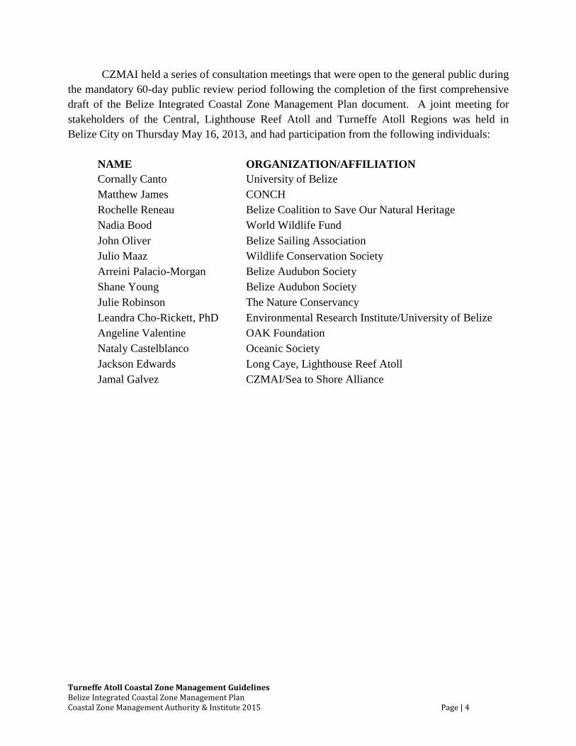
CZMAI held a series of consultation meetings that were open to the general public during
the mandatory 60-day public review period following the completion of the first comprehensive
draft of the Belize Integrated Coastal Zone Management Plan document. A joint meeting for
stakeholders of the Central, Lighthouse Reef Atoll and Turneffe Atoll Regions was held in
Belize City on Thursday May 16, 2013, and had participation from the following individuals:
NAME
ORGANIZATION/AFFILIATION
Cornally Canto University of Belize
Matthew James CONCH
Rochelle Reneau Belize Coalition to Save Our Natural Heritage
Nadia Bood World Wildlife Fund
John Oliver Belize Sailing Association
Julio Maaz Wildlife Conservation Society
Arreini Palacio-Morgan Belize Audubon Society
Shane Young Belize Audubon Society
Julie Robinson The Nature Conservancy
Leandra Cho-Rickett, PhD Environmental Research Institute/University of Belize
Angeline Valentine OAK Foundation
Nataly Castelblanco Oceanic Society
Jackson Edwards Long Caye, Lighthouse Reef Atoll
Jamal Galvez CZMAI/Sea to Shore Alliance
Turneffe Atoll Coastal Zone Management Guidelines Belize Integrated Coastal Zone Management Plan Coastal Zone Management Authority & Institute 2015 Page | 5
Table of Contents ACKNOWLEDGEMENTS ......................................................................................................................2
LIST OF MAPS.....................................................................................................................................7
LIST OF FIGURES .................................................................................................................................7
LIST OF TABLES ..................................................................................................................................8
LIST OF ACRONYMS ............................................................................................................................9
GLOSSARY OF TERMS ....................................................................................................................... 10
PREAMBLE ....................................................................................................................................... 13
1.0 INTRODUCTION .................................................................................................................... 15
2.0 REGION BOUNDARIES ........................................................................................................... 17
Location and Geographic Definition....................................................................................................... 17
Regional Context .................................................................................................................................... 17
3.0 OBJECTIVES ........................................................................................................................... 22
4.0 LEGISLATIVE AND INSTITUTIONAL FRAMEWORK FOR INTEGRATED COASTAL ZONE
MANAGEMENT IN BELIZE ................................................................................................................. 23
5.0 GUIDING PRINCIPLES ............................................................................................................. 26
6.0 SECTORAL POLICIES ............................................................................................................... 27
6.1 Fishing......................................................................................................................................... 27
6.2 Marine Tourism and Recreation ................................................................................................. 33
6.3 Land-Use ..................................................................................................................................... 38
6.3.1 Cayes Development Standards ............................................................................................ 40
6.4 Marine Dredging and Mineral Extraction ................................................................................... 78
6.5 Sensitive Habitats ........................................................................................................................ 79
6.5.1 Corals .................................................................................................................................. 79
6.5.2 Mangroves ........................................................................................................................... 80
6.5.3 Seagrass ............................................................................................................................... 83
6.6 Utilities ........................................................................................................................................ 86
6.7 Pollution Control ......................................................................................................................... 90
6.8 Social Amenities and Recreation ................................................................................................ 92
6.9 Conservation ............................................................................................................................... 93
6.10 Scientific Research and Education .............................................................................................. 97
Turneffe Atoll Coastal Zone Management Guidelines Belize Integrated Coastal Zone Management Plan Coastal Zone Management Authority & Institute 2015 Page | 6
7.0 IMPLEMENTATION STRATEGY ............................................................................................... 98
8.0 CONCLUSIONS .................................................................................................................... 100
9.0 REFERENCES ....................................................................................................................... 101
10.0 APPENDICES ....................................................................................................................... 103
10.1 Background ............................................................................................................................... 103
10.2 Summary Of Enabling Legislation And Implementing Agencies For Enforcement Of The
Informed Management Zoning Scheme ................................................................................................ 105
10.3 Checklist For Human Use/Development Of The Coastal Zone ................................................ 108
10.4 Figures....................................................................................................................................... 112
Turneffe Atoll Coastal Zone Management Guidelines Belize Integrated Coastal Zone Management Plan Coastal Zone Management Authority & Institute 2015 Page | 7
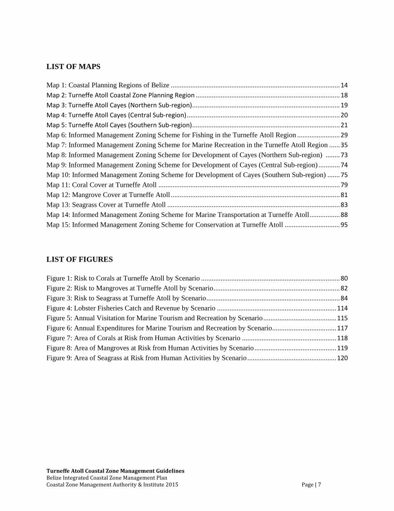
LIST OF MAPS
Map 1: Coastal Planning Regions of Belize ............................................................................................... 14
Map 2: Turneffe Atoll Coastal Zone Planning Region ................................................................................. 18
Map 3: Turneffe Atoll Cayes (Northern Sub-region) ................................................................................... 19
Map 4: Turneffe Atoll Cayes (Central Sub-region) ...................................................................................... 20
Map 5: Turneffe Atoll Cayes (Southern Sub-region) ................................................................................... 21
Map 6: Informed Management Zoning Scheme for Fishing in the Turneffe Atoll Region ........................ 29
Map 7: Informed Management Zoning Scheme for Marine Recreation in the Turneffe Atoll Region ...... 35
Map 8: Informed Management Zoning Scheme for Development of Cayes (Northern Sub-region) ........ 73
Map 9: Informed Management Zoning Scheme for Development of Cayes (Central Sub-region) ............ 74
Map 10: Informed Management Zoning Scheme for Development of Cayes (Southern Sub-region) ....... 75
Map 11: Coral Cover at Turneffe Atoll ...................................................................................................... 79
Map 12: Mangrove Cover at Turneffe Atoll ............................................................................................... 81
Map 13: Seagrass Cover at Turneffe Atoll ................................................................................................. 83
Map 14: Informed Management Zoning Scheme for Marine Transportation at Turneffe Atoll ................. 88
Map 15: Informed Management Zoning Scheme for Conservation at Turneffe Atoll ............................... 95
LIST OF FIGURES
Figure 1: Risk to Corals at Turneffe Atoll by Scenario .............................................................................. 80
Figure 2: Risk to Mangroves at Turneffe Atoll by Scenario ....................................................................... 82
Figure 3: Risk to Seagrass at Turneffe Atoll by Scenario ........................................................................... 84
Figure 4: Lobster Fisheries Catch and Revenue by Scenario ................................................................... 114
Figure 5: Annual Visitation for Marine Tourism and Recreation by Scenario ......................................... 115
Figure 6: Annual Expenditures for Marine Tourism and Recreation by Scenario .................................... 117
Figure 7: Area of Corals at Risk from Human Activities by Scenario ..................................................... 118
Figure 8: Area of Mangroves at Risk from Human Activities by Scenario .............................................. 119
Figure 9: Area of Seagrass at Risk from Human Activities by Scenario .................................................. 120
Turneffe Atoll Coastal Zone Management Guidelines Belize Integrated Coastal Zone Management Plan Coastal Zone Management Authority & Institute 2015 Page | 8
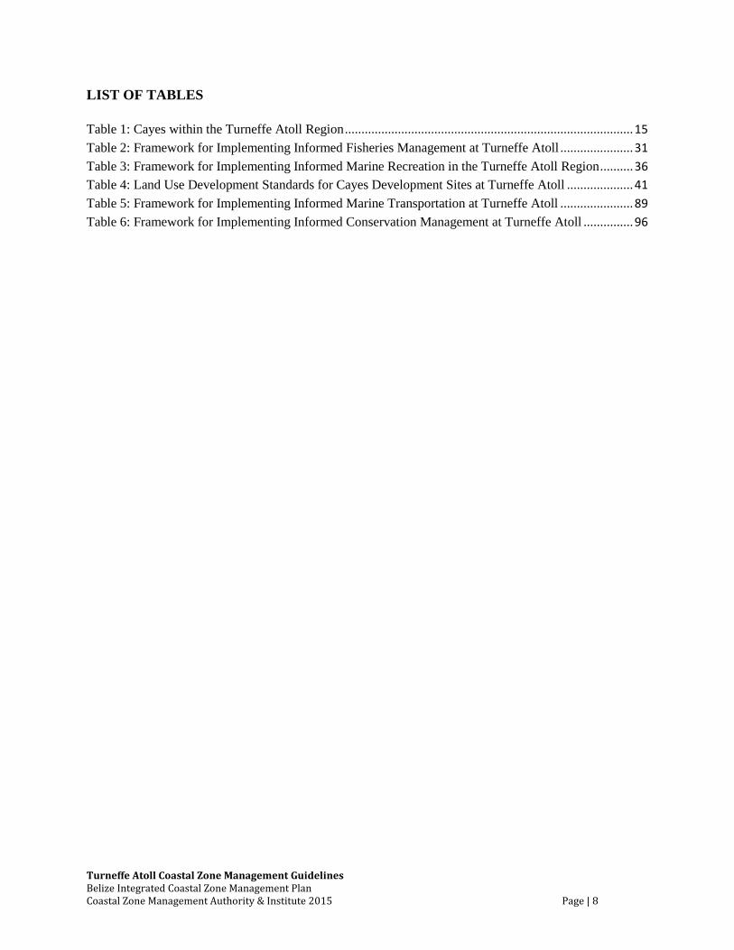
LIST OF TABLES
Table 1: Cayes within the Turneffe Atoll Region ....................................................................................... 15
Table 2: Framework for Implementing Informed Fisheries Management at Turneffe Atoll ...................... 31
Table 3: Framework for Implementing Informed Marine Recreation in the Turneffe Atoll Region .......... 36
Table 4: Land Use Development Standards for Cayes Development Sites at Turneffe Atoll .................... 41
Table 5: Framework for Implementing Informed Marine Transportation at Turneffe Atoll ...................... 89
Table 6: Framework for Implementing Informed Conservation Management at Turneffe Atoll ............... 96
Turneffe Atoll Coastal Zone Management Guidelines Belize Integrated Coastal Zone Management Plan Coastal Zone Management Authority & Institute 2015 Page | 9
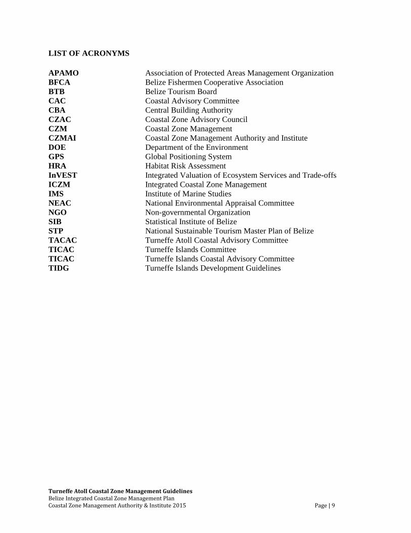
LIST OF ACRONYMS
APAMO Association of Protected Areas Management Organization
BFCA Belize Fishermen Cooperative Association
BTB Belize Tourism Board
CAC Coastal Advisory Committee
CBA Central Building Authority
CZAC Coastal Zone Advisory Council
CZM Coastal Zone Management
CZMAI Coastal Zone Management Authority and Institute
DOE Department of the Environment
GPS Global Positioning System
HRA Habitat Risk Assessment
InVEST Integrated Valuation of Ecosystem Services and Trade-offs
ICZM Integrated Coastal Zone Management
IMS Institute of Marine Studies
NEAC National Environmental Appraisal Committee
NGO Non-governmental Organization
SIB Statistical Institute of Belize
STP National Sustainable Tourism Master Plan of Belize
TACAC Turneffe Atoll Coastal Advisory Committee
TICAC Turneffe Islands Committee
TICAC Turneffe Islands Coastal Advisory Committee
TIDG Turneffe Islands Development Guidelines
Turneffe Atoll Coastal Zone Management Guidelines Belize Integrated Coastal Zone Management Plan Coastal Zone Management Authority & Institute 2015 Page | 10
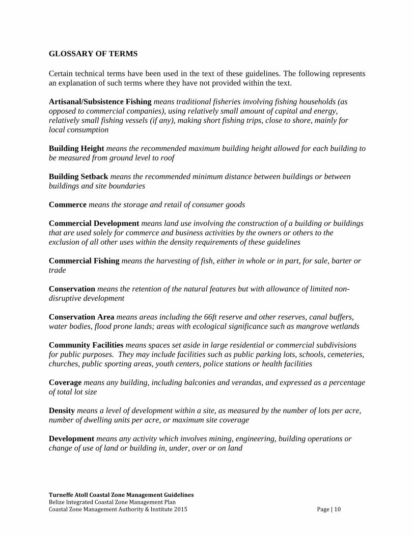
GLOSSARY OF TERMS
Certain technical terms have been used in the text of these guidelines. The following represents
an explanation of such terms where they have not provided within the text.
Artisanal/Subsistence Fishing means traditional fisheries involving fishing households (as
opposed to commercial companies), using relatively small amount of capital and energy,
relatively small fishing vessels (if any), making short fishing trips, close to shore, mainly for
local consumption
Building Height means the recommended maximum building height allowed for each building to
be measured from ground level to roof
Building Setback means the recommended minimum distance between buildings or between
buildings and site boundaries
Commerce means the storage and retail of consumer goods
Commercial Development means land use involving the construction of a building or buildings
that are used solely for commerce and business activities by the owners or others to the
exclusion of all other uses within the density requirements of these guidelines
Commercial Fishing means the harvesting of fish, either in whole or in part, for sale, barter or
trade
Conservation means the retention of the natural features but with allowance of limited non-
disruptive development
Conservation Area means areas including the 66ft reserve and other reserves, canal buffers,
water bodies, flood prone lands; areas with ecological significance such as mangrove wetlands
Community Facilities means spaces set aside in large residential or commercial subdivisions
for public purposes. They may include facilities such as public parking lots, schools, cemeteries,
churches, public sporting areas, youth centers, police stations or health facilities
Coverage means any building, including balconies and verandas, and expressed as a percentage
of total lot size
Density means a level of development within a site, as measured by the number of lots per acre,
number of dwelling units per acre, or maximum site coverage
Development means any activity which involves mining, engineering, building operations or
change of use of land or building in, under, over or on land
Turneffe Atoll Coastal Zone Management Guidelines Belize Integrated Coastal Zone Management Plan Coastal Zone Management Authority & Institute 2015 Page | 11
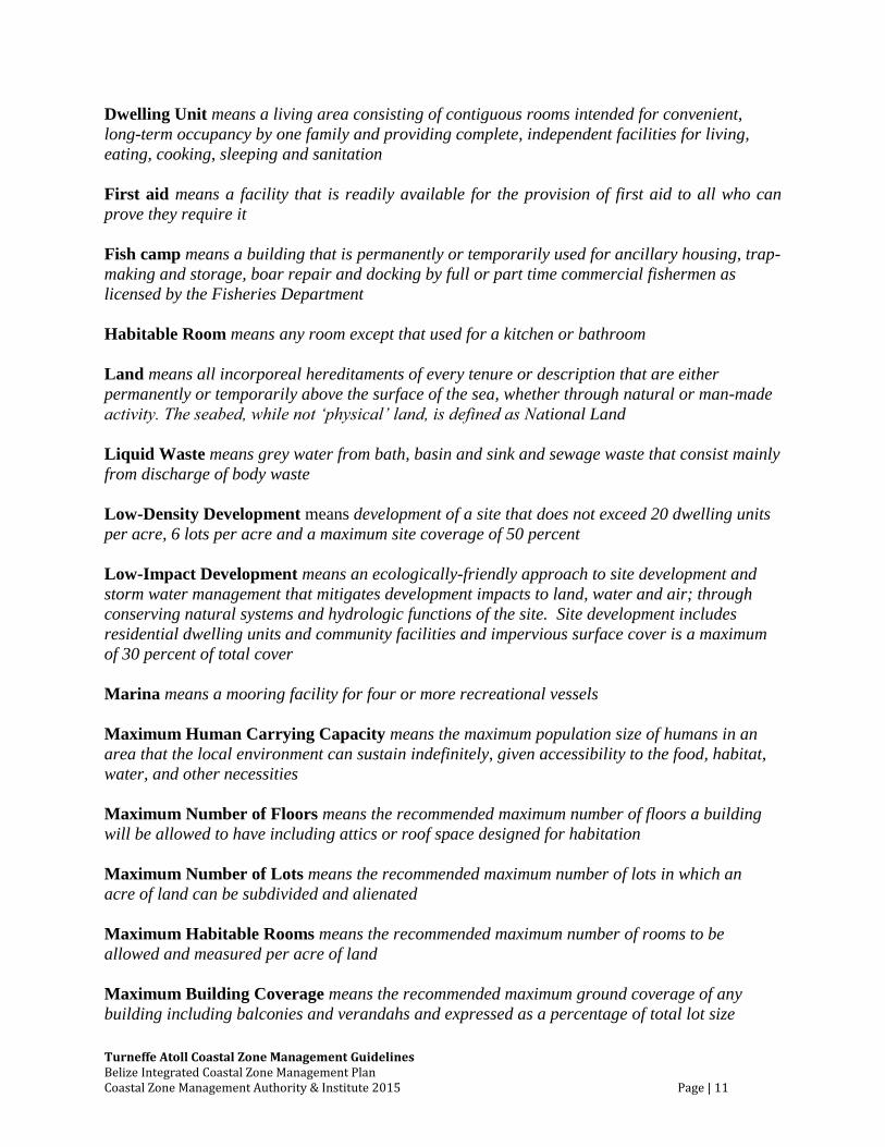
Dwelling Unit means a living area consisting of contiguous rooms intended for convenient,
long-term occupancy by one family and providing complete, independent facilities for living,
eating, cooking, sleeping and sanitation
First aid means a facility that is readily available for the provision of first aid to all who can
prove they require it
Fish camp means a building that is permanently or temporarily used for ancillary housing, trap-
making and storage, boar repair and docking by full or part time commercial fishermen as
licensed by the Fisheries Department
Habitable Room means any room except that used for a kitchen or bathroom
Land means all incorporeal hereditaments of every tenure or description that are either
permanently or temporarily above the surface of the sea, whether through natural or man-made
activity. The seabed, while not ‘physical’ land, is defined as National Land
Liquid Waste means grey water from bath, basin and sink and sewage waste that consist mainly
from discharge of body waste
Low-Density Development means development of a site that does not exceed 20 dwelling units
per acre, 6 lots per acre and a maximum site coverage of 50 percent
Low-Impact Development means an ecologically-friendly approach to site development and
storm water management that mitigates development impacts to land, water and air; through
conserving natural systems and hydrologic functions of the site. Site development includes
residential dwelling units and community facilities and impervious surface cover is a maximum
of 30 percent of total cover
Marina means a mooring facility for four or more recreational vessels
Maximum Human Carrying Capacity means the maximum population size of humans in an
area that the local environment can sustain indefinitely, given accessibility to the food, habitat,
water, and other necessities
Maximum Number of Floors means the recommended maximum number of floors a building
will be allowed to have including attics or roof space designed for habitation
Maximum Number of Lots means the recommended maximum number of lots in which an
acre of land can be subdivided and alienated
Maximum Habitable Rooms means the recommended maximum number of rooms to be
allowed and measured per acre of land
Maximum Building Coverage means the recommended maximum ground coverage of any
building including balconies and verandahs and expressed as a percentage of total lot size
Turneffe Atoll Coastal Zone Management Guidelines Belize Integrated Coastal Zone Management Plan Coastal Zone Management Authority & Institute 2015 Page | 12
Maximum Site Clearance means the recommended maximum amount of land that will be
allowed to be cleared expressed as a percentage of the total site area
Medium-Density Development means development of a site that does not exceed 40 dwelling
units per acre, 8 lots per acre and a maximum site coverage of 66 percent
Medium-Impact Development means an ecologically-friendly approach to site development
and storm water management that mitigates development impacts to land, water and air;
through conserving natural systems and hydrologic functions of the site. Site development
includes a combination of residential dwelling units, community facilities and commercial
activities, and impervious surface cover is a maximum of 50 percent of total cover
Minimum Lot Size means the recommended smallest size a parcel will be allowed to be
alienated
National Land means all lands, including cayes and parts thereof not already located or
granted, and any lands which have been, or may hereafter become, escheated to, leased by, or
otherwise acquired by the Government
Piers per Site means the recommended number of piers that will be allowed to be constructed on
any site
Primary Land Use means the recommended preferred use for the site
Residential Development means land use that involves the construction of a building or
buildings that are used solely for permanent or temporary domiciles by the owners or others on
a non-commercial basis to the exclusion of all other uses within the density requirements of these
guidelines
Resort means a building, buildings or site which offers accommodation and general amenities to
visitors with other uses such as bars, restaurants, general storage and repair facilities and
docking
Secondary Land means the recommended next preferred use to be applied to the site either in
conjunction with the primary land use or as an alternative to the primary land use if that is not
applicable
Solid Waste means any unwanted material that is useless and thrown away or, discarded
Swamp means an area of very shallow lagoon with mud, savannah or very low vegetation
Utility means the service and infrastructure used for the supply of energy, water, communication
and waste disposal
Turneffe Atoll Coastal Zone Management Guidelines Belize Integrated Coastal Zone Management Plan Coastal Zone Management Authority & Institute 2015 Page | 13
PREAMBLE
The Belize Coastal Zone Management Authority and Institute (CZMAI), a statutory body
established by the Coastal Zone Management (CZM) Act of 1998, is tasked with the broad
responsibility of assisting with the development of policies, strategies and guidelines for the
improved management and sustainable use of the country’s coastal resources at a national level.
In keeping with its mandate to prepare an integrated coastal zone management plan, CZMAI has
developed regional coastal zone management guidelines to provide support for planned
development and resource management along the coastline and offshore areas of the entire
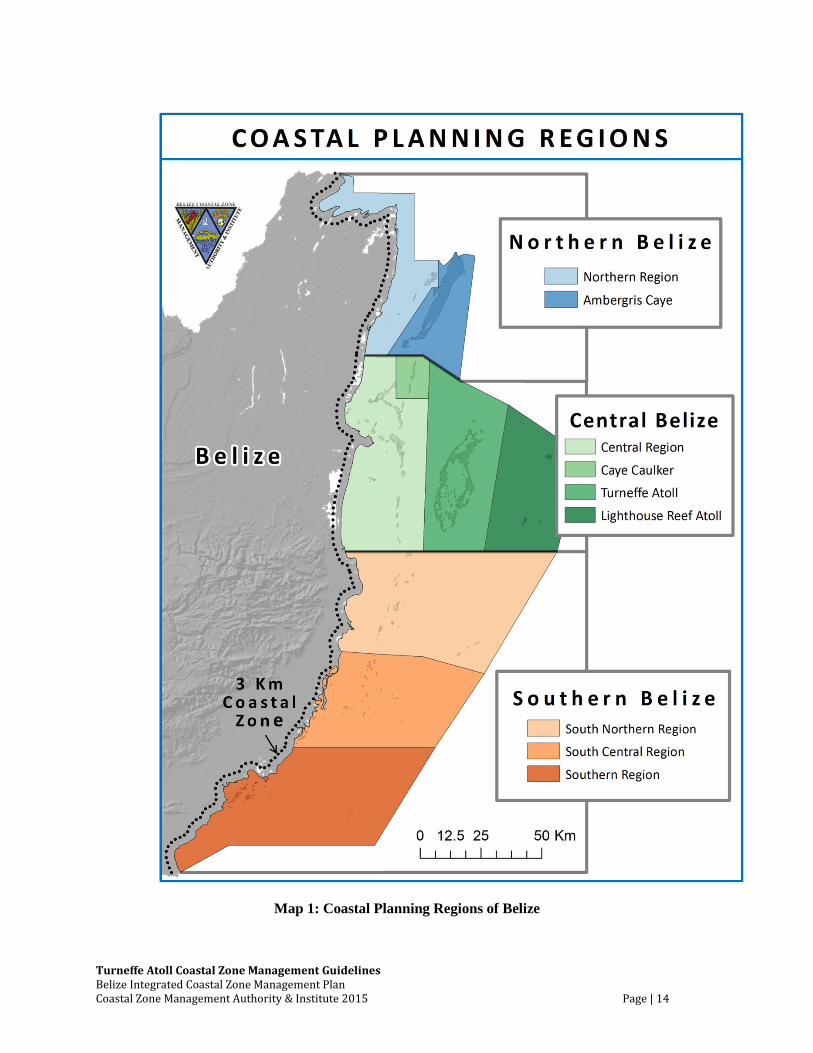
country. These guidelines have been prepared for nine (9) coastal planning regions (Map 1),
which were demarcated based on commonalities, geographic definition and regional
characteristics. The coastal zone management guidelines will help to integrate management
efforts across the land-sea interface.
The Turneffe Atoll Coastal Zone Management Guidelines were developed in conjunction
with the stakeholder groups of the region. Turneffe Atoll, the largest of three offshore atolls
within Belize’s territorial waters, has limited anthropogenic threats and high marine biodiversity.
Using the expert subjective information from stakeholders in addition to the best available
objective data, CZMAI was able to produce this guideline with the following goals:
1. Encourage and promote the sustainable development of Turneffe Atoll that will sustain
the economic, social and ecological value of the atoll while simultaneously ensuring
ecosystem integrity and the efficient delivery of ecosystem services.
2. Ensure that Turneffe Atoll’s valuable commercial fishery is managed sustainably through
the implementation of modern fisheries management strategies, and its tourism industry
is managed by facilitating low-impact, nature-based tourism capitalizing on its unique
natural assets.
3. Ensure sustainability of coastal resources by identifying unique and environmentally
sensitive areas that are in need of conservation, and reducing user conflicts
These goals are informed, and rooted, where possible, on sound science and local
knowledge. These guidelines represent the views and recommendations of the stakeholders of
the Turneffe Atoll coastal planning region. They are also a response towards addressing the
management gaps identified by stakeholder communities through an extensive consultation
process. The coastal zone management guidelines will ensure that human use of the coastal
region occurs in consideration of the carrying capacity of the environment in addition to other
ecological, cultural, social and economic development priorities of the region. These guidelines
will aid policy development for integrated coastal zone management. They will be implemented
by all those agencies that have legal mandates and/or permitting powers that impact resource
utilization in the coastal zone of Belize, in partnership with this region’s stakeholder groups.
Turneffe Atoll Coastal Zone Management Guidelines Belize Integrated Coastal Zone Management Plan Coastal Zone Management Authority & Institute 2015 Page | 14
Map 1: Coastal Planning Regions of Belize
Turneffe Atoll Coastal Zone Management Guidelines Belize Integrated Coastal Zone Management Plan Coastal Zone Management Authority & Institute 2015 Page | 15
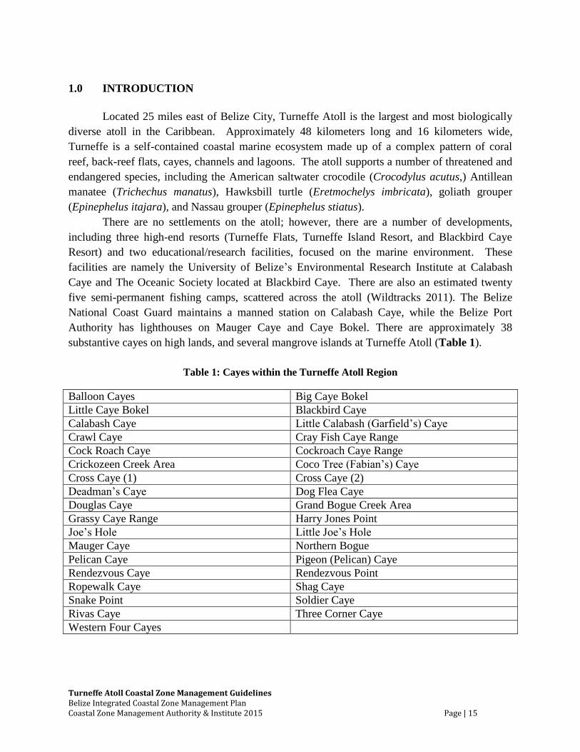
1.0 INTRODUCTION
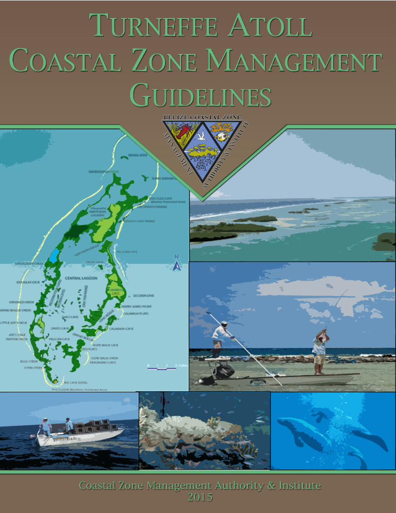
Located 25 miles east of Belize City, Turneffe Atoll is the largest and most biologically
diverse atoll in the Caribbean. Approximately 48 kilometers long and 16 kilometers wide,
Turneffe is a self-contained coastal marine ecosystem made up of a complex pattern of coral
reef, back-reef flats, cayes, channels and lagoons. The atoll supports a number of threatened and
endangered species, including the American saltwater crocodile (Crocodylus acutus,) Antillean
manatee (Trichechus manatus), Hawksbill turtle (Eretmochelys imbricata), goliath grouper
(Epinephelus itajara), and Nassau grouper (Epinephelus stiatus).
There are no settlements on the atoll; however, there are a number of developments,
including three high-end resorts (Turneffe Flats, Turneffe Island Resort, and Blackbird Caye
Resort) and two educational/research facilities, focused on the marine environment. These
facilities are namely the University of Belize’s Environmental Research Institute at Calabash
Caye and The Oceanic Society located at Blackbird Caye. There are also an estimated twenty
five semi-permanent fishing camps, scattered across the atoll (Wildtracks 2011). The Belize
National Coast Guard maintains a manned station on Calabash Caye, while the Belize Port
Authority has lighthouses on Mauger Caye and Caye Bokel. There are approximately 38
substantive cayes on high lands, and several mangrove islands at Turneffe Atoll (Table 1).
Table 1: Cayes within the Turneffe Atoll Region
Balloon Cayes Big Caye Bokel
Little Caye Bokel Blackbird Caye
Calabash Caye Little Calabash (Garfield’s) Caye
Crawl Caye Cray Fish Caye Range
Cock Roach Caye Cockroach Caye Range
Crickozeen Creek Area Coco Tree (Fabian’s) Caye
Cross Caye (1) Cross Caye (2)
Deadman’s Caye Dog Flea Caye
Douglas Caye Grand Bogue Creek Area
Grassy Caye Range Harry Jones Point
Joe’s Hole Little Joe’s Hole
Mauger Caye Northern Bogue
Pelican Caye Pigeon (Pelican) Caye
Rendezvous Caye Rendezvous Point
Ropewalk Caye Shag Caye
Snake Point Soldier Caye
Rivas Caye Three Corner Caye
Western Four Cayes
Turneffe Atoll Coastal Zone Management Guidelines Belize Integrated Coastal Zone Management Plan Coastal Zone Management Authority & Institute 2015 Page | 16
For decades, Turneffe has been a major contributor to Belize’s commercial harvest of
lobster, conch and finfish. Additionally, the atoll is known worldwide as a sport fishing and
scuba diving destination, and it is also an important center for marine research. Over the past
decade, development pressures have increased enormously. Since 2000, the transfer of property
from national ownership to private ownership has skyrocketed with large stands of mangroves
cleared and critically important marine areas dredged and destroyed. Reversing this ominous
trend will be difficult, if not impossible, without sustainable management of the atoll. There
have been several attempts over that past two decades to develop a management structure for
Turneffe. It was not until November 2012 that the atoll was officially declared the Turneffe
Atoll Marine Reserve, now the largest marine reserve in the country.
The coastal zone management guidelines have been prepared with a view to guiding
current and future sustainable development activities on Turneffe Atoll and all the cayes that lie
in the region. The guidelines are based on provisions set out in the National Integrated Coastal
Zone Management Strategy for Belize 2003 for sustainable coastal area use and management.
The policy recommendations include, but are not limited to, the following: fishing and tourism
development, land use planning and development management, land tenure, conservation of
natural resources, mineral extraction, waste disposal, and national strategic consideration.
Turneffe Atoll Coastal Zone Management Guidelines Belize Integrated Coastal Zone Management Plan Coastal Zone Management Authority & Institute 2015 Page | 17
2.0 REGION BOUNDARIES
Location and Geographic Definition
The Turneffe Atoll coastal planning region, for which these coastal zone management
guidelines have been prepared, is one of nine regions into which the coastal zone has been
demarcated (Map 1). The atoll itself is located 20 miles east of Belize City. The entire Turneffe
Atoll coastal planning region has approximately 2016 square kilometers (Map 2), while the
marine protected encompasses an area of 1317 square kilometers. It is comprised of all that area
enclosed by the lines joining points that have the following UTM 16 coordinates (Map 2):
Point 1: (1968025 N, 397695 E)
Point 2: (1950417 N, 429682 E)
Point 3: (1890259 N, 419998 E)
Point 4: (1889965 N, 395054 E)
Regional Context
Turneffe Atoll is approximately 48 kilometers long and 16 kilometers wide. It is
bordered by the Lighthouse Reef Atoll planning region to the east, and the Central and Caye
Caulker planning regions to the west. It is surrounded by very deep oceanic waters, extending
from a depth of 200m and deeper. Terrestrial habitats account for approximately 115 square
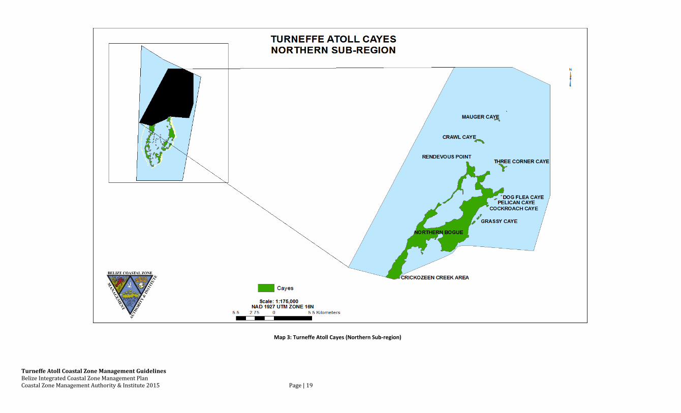
kilometers. There are also approximately 38 cayes and several mangrove islands (Maps 3, 4, 5)
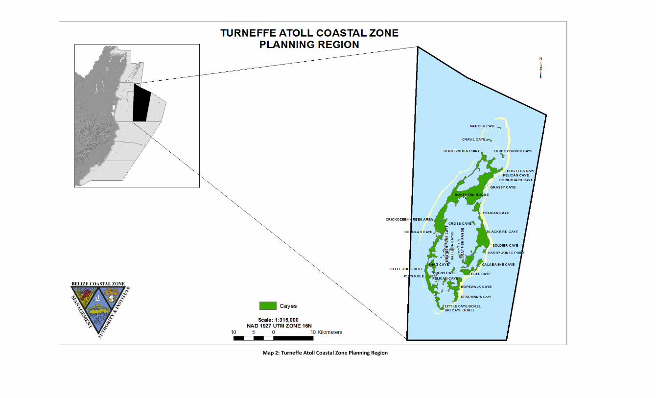
Map 2: Turneffe Atoll Coastal Zone Planning Region
Turneffe Atoll Coastal Zone Management Guidelines Belize Integrated Coastal Zone Management Plan Coastal Zone Management Authority & Institute 2015 Page | 19
Map 3: Turneffe Atoll Cayes (Northern Sub-region)
Turneffe Atoll Coastal Zone Management Guidelines Belize Integrated Coastal Zone Management Plan Coastal Zone Management Authority & Institute 2015 Page | 20
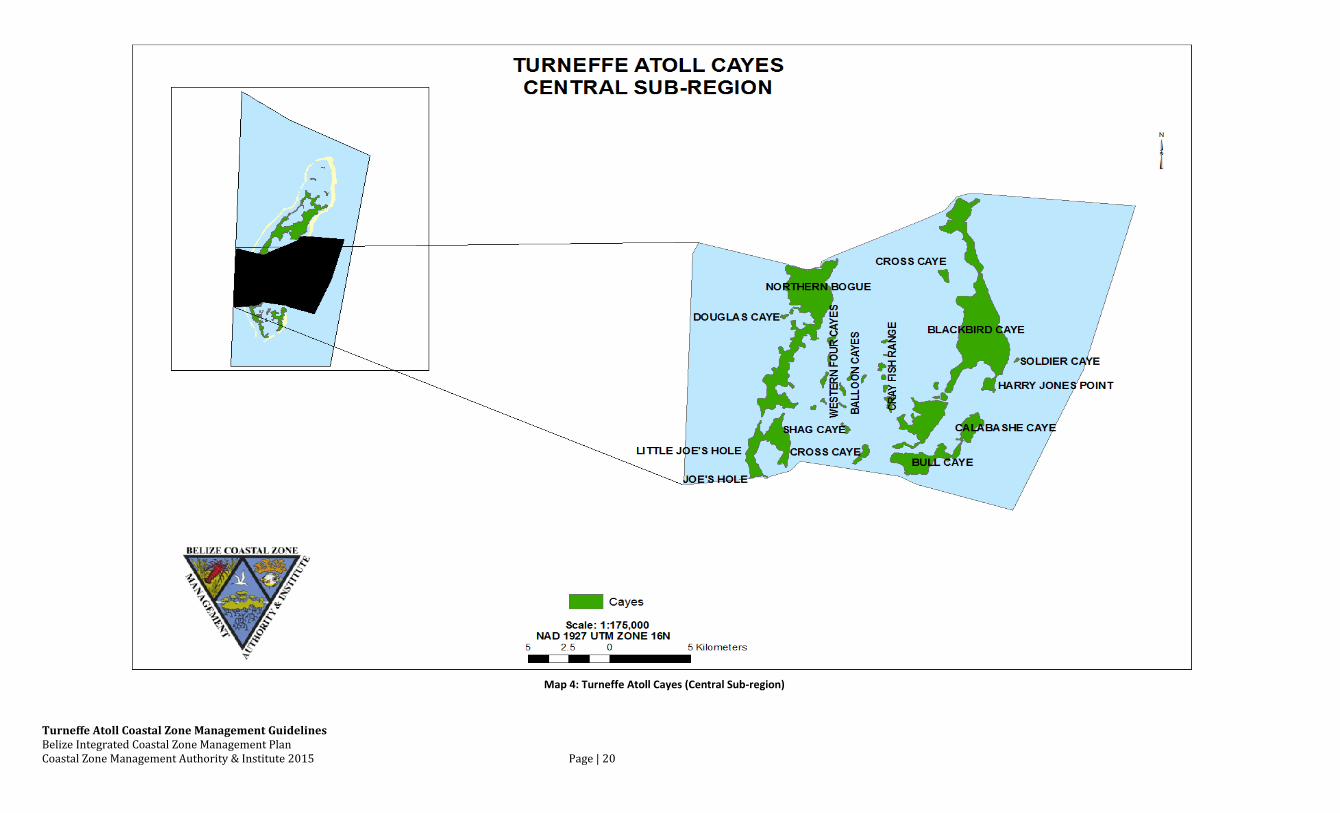
Map 4: Turneffe Atoll Cayes (Central Sub-region)
Turneffe Atoll Coastal Zone Management Guidelines Belize Integrated Coastal Zone Management Plan Coastal Zone Management Authority & Institute 2015 Page | 21
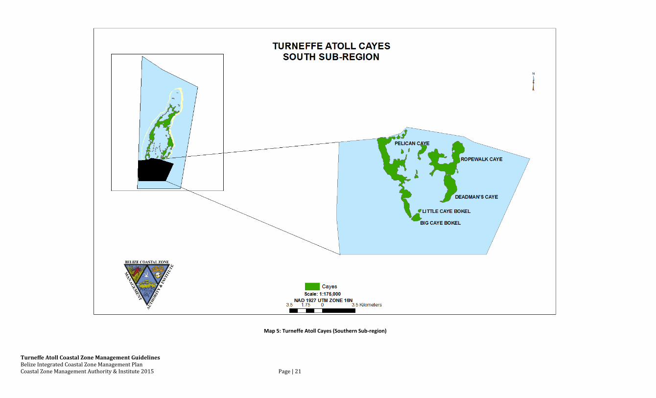
Map 5: Turneffe Atoll Cayes (Southern Sub-region)
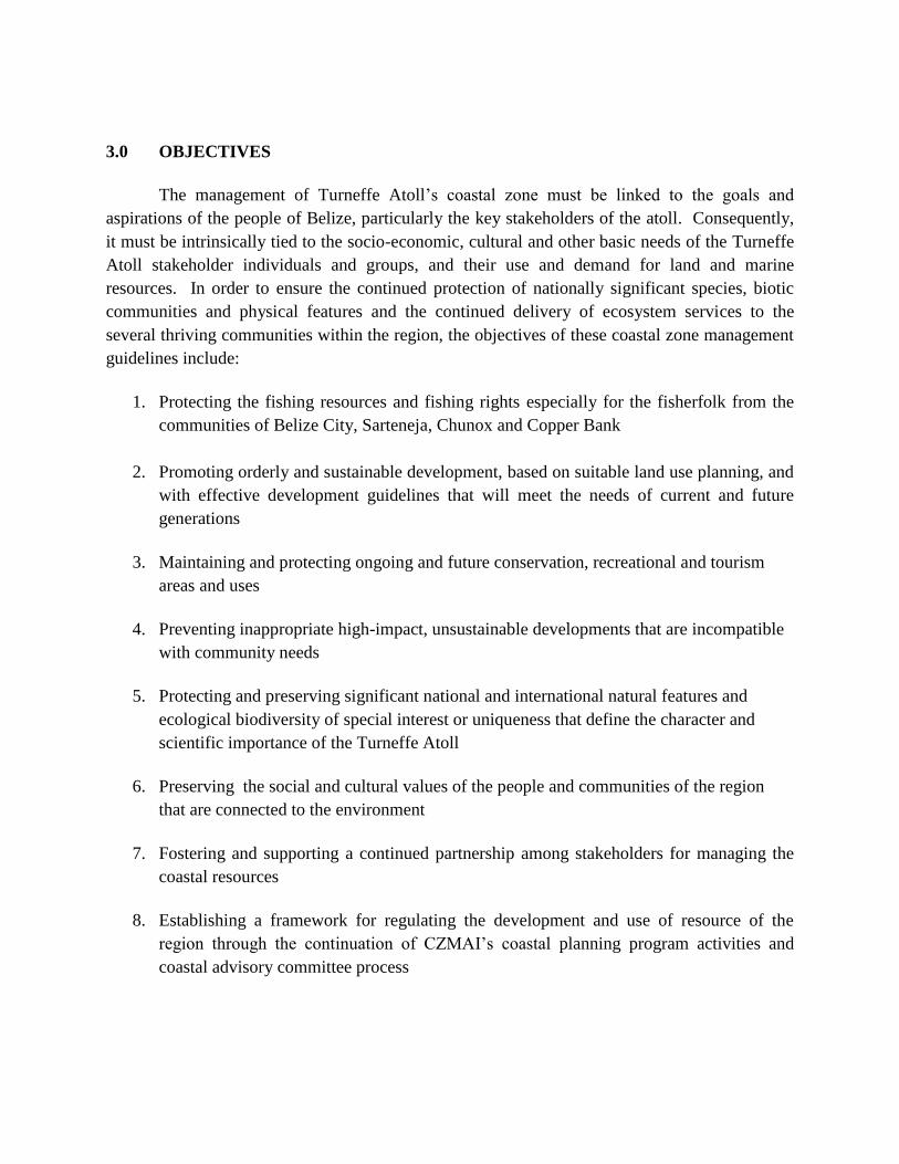
3.0 OBJECTIVES
The management of Turneffe Atoll’s coastal zone must be linked to the goals and
aspirations of the people of Belize, particularly the key stakeholders of the atoll. Consequently,
it must be intrinsically tied to the socio-economic, cultural and other basic needs of the Turneffe
Atoll stakeholder individuals and groups, and their use and demand for land and marine
resources. In order to ensure the continued protection of nationally significant species, biotic
communities and physical features and the continued delivery of ecosystem services to the
several thriving communities within the region, the objectives of these coastal zone management
guidelines include:
1. Protecting the fishing resources and fishing rights especially for the fisherfolk from the
communities of Belize City, Sarteneja, Chunox and Copper Bank
2. Promoting orderly and sustainable development, based on suitable land use planning, and
with effective development guidelines that will meet the needs of current and future
generations
3. Maintaining and protecting ongoing and future conservation, recreational and tourism
areas and uses
4. Preventing inappropriate high-impact, unsustainable developments that are incompatible
with community needs
5. Protecting and preserving significant national and international natural features and
ecological biodiversity of special interest or uniqueness that define the character and
scientific importance of the Turneffe Atoll
6. Preserving the social and cultural values of the people and communities of the region
that are connected to the environment
7. Fostering and supporting a continued partnership among stakeholders for managing the
coastal resources
8. Establishing a framework for regulating the development and use of resource of the
region through the continuation of CZMAI’s coastal planning program activities and
coastal advisory committee process
Turneffe Atoll Coastal Zone Management Guidelines Belize Integrated Coastal Zone Management Plan Coastal Zone Management Authority & Institute 2015 Page | 23
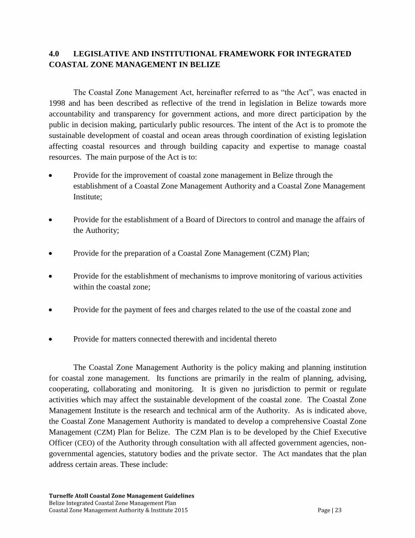
4.0 LEGISLATIVE AND INSTITUTIONAL FRAMEWORK FOR INTEGRATED
COASTAL ZONE MANAGEMENT IN BELIZE
The Coastal Zone Management Act, hereinafter referred to as “the Act”, was enacted in
1998 and has been described as reflective of the trend in legislation in Belize towards more
accountability and transparency for government actions, and more direct participation by the
public in decision making, particularly public resources. The intent of the Act is to promote the
sustainable development of coastal and ocean areas through coordination of existing legislation
affecting coastal resources and through building capacity and expertise to manage coastal
resources. The main purpose of the Act is to:
Provide for the improvement of coastal zone management in Belize through the
establishment of a Coastal Zone Management Authority and a Coastal Zone Management
Institute;
Provide for the establishment of a Board of Directors to control and manage the affairs of
the Authority;
Provide for the preparation of a Coastal Zone Management (CZM) Plan;
Provide for the establishment of mechanisms to improve monitoring of various activities
within the coastal zone;
Provide for the payment of fees and charges related to the use of the coastal zone and
Provide for matters connected therewith and incidental thereto
The Coastal Zone Management Authority is the policy making and planning institution
for coastal zone management. Its functions are primarily in the realm of planning, advising,
cooperating, collaborating and monitoring. It is given no jurisdiction to permit or regulate
activities which may affect the sustainable development of the coastal zone. The Coastal Zone
Management Institute is the research and technical arm of the Authority. As is indicated above,
the Coastal Zone Management Authority is mandated to develop a comprehensive Coastal Zone
Management (CZM) Plan for Belize. The CZM Plan is to be developed by the Chief Executive
Officer (CEO) of the Authority through consultation with all affected government agencies, non-
governmental agencies, statutory bodies and the private sector. The Act mandates that the plan
address certain areas. These include:
Turneffe Atoll Coastal Zone Management Guidelines Belize Integrated Coastal Zone Management Plan Coastal Zone Management Authority & Institute 2015 Page | 24
Guidelines to be used in determining the suitability of particular development activities in
the coastal zone;
Guidelines for the general monitoring of the coastal zone, including its biological species,
communities and habitats;
Proposals, including existing proposals from Government agencies, relating to the coastal
zone that deal with the following subjects:
o Land use
o Planning for the establishment of marine protected areas and for the conservation
of threatened or potentially threatened or endangered species;
o Preservation and management of the scenic, cultural and other natural resources;
o Recreation and tourism;
o Monitoring of the environment and natural resources, mineral extraction, living
resources, human settlements, agriculture, aquaculture, and industry
Proposals for the reservation of land or water in the coastal zone for certain uses, or for
the prohibition of certain activities in certain areas of the coastal zone;
Recommendation for the improvement of public education as well as public participation
in the management of coastal resources;
Recommendations for strengthening governmental policies and powers and the conduct
of research for the purposes of coastal resources conservation and management
The process for approval of the CZM Plan is as follows: The Act requires the CEO of the
Authority to submit the CZM Plan to the Board of the Authority, who has sixty days to make
modifications. Thereafter, the Board is to notify the public of the availability of the CZM Plan
by an order published in the Gazette. Any member of the public may submit comments within
sixty days. Upon completion of the sixty days, the Board may approve the CZM Plan, subject to
modifications, if they deem it fit in regard to the comments submitted, and then submit the same
to the Minister for approval. The Minister, after approving the CZM Plan, shall table it in the
House of Representatives for approval by the House by affirmative resolution. Subsequent to
approval by the House, the CZM Plan must be published in three consecutive issues of the
Gazette. The CZM Plan is to come into operation on the date of the last publication or such later
date as may be specified therein. The Act requires the CZM Plan to be revised during the four
year period after it comes into operation.
Turneffe Atoll Coastal Zone Management Guidelines Belize Integrated Coastal Zone Management Plan Coastal Zone Management Authority & Institute 2015 Page | 25
It was agreed by the CZMAI that the CZM Plan would be developed in phases, with the
first phase being the development of an Integrated Coastal Zone Management Strategy
document, which underwent extensive public consultation. It was endorsed by the cabinet in
2003, and is an official policy document of CZMAI. The second phase involved the formulation
of cayes development guidelines for eight of the nine coastal planning regions into which the
coastal zone has been sub-divided by the CZMAI. This subdivision was based on geographical,
biological, administrative and economic similarities. The Ambergris Caye Development Master
Plan serves as a guide for regulating the use and development of land in the Ambergris Caye
Planning Region. See Map 1 for the definition of the nine coastal planning regions.
The development guidelines were formulated using the Cayes Development Policy
(2001) as a framework. During 2010-2012, the cayes development guidelines were updated to
include new information on the cayes, but also to include human use of the coastline and marine
waters. As such, the development guidelines have been renamed the coastal zone management
guidelines. Thus, the Integrated Coastal Zone Management Strategy (2003), together with the
coastal zone management guidelines for the nine coastal planning regions, contributes to the
development of the comprehensive Integrated Coastal Zone Management Plan.
Turneffe Atoll Coastal Zone Management Guidelines Belize Integrated Coastal Zone Management Plan Coastal Zone Management Authority & Institute 2015 Page | 26
5.0 GUIDING PRINCIPLES
It is important that the coastal zone management guidelines for the region be formulated
as a part of a sustainable plan geared towards contributing to national, regional and local
development policies, goals and aspirations. They must therefore be holistic and pragmatic, yet
underpinned by certain fundamental principles. These can be detailed as follows:
Principle 1:- Recognition that the Turneffe Atoll Region needs special protection and
management because of its physical, economic, scientific, cultural and aesthetic attributes
Principle 2:- Recognition of the need to avoid placing undue strain on the terrestrial and
aquatic environment of the region by ensuring that proposed development activities do not
exceed the carrying capacity of the region
Principle 3:- Recognition of the rights and interests of traditional users and stakeholders while
acknowledging the national development policy which promotes tourism and job creation
Principle 4:- Recognition that environmental concerns are best handled with the participation of
all concerned stakeholders at all levels and from all sectors
Principle 5:- Recognition that planning guidelines represent a preventative and precautionary
approach to environmental degradation and a tool for pursuing sustainable development of the
region
Turneffe Atoll Coastal Zone Management Guidelines Belize Integrated Coastal Zone Management Plan Coastal Zone Management Authority & Institute 2015 Page | 27
6.0 SECTORAL POLICIES
These policies are organized into ten sectors which address current and potential issues at
Turneffe Atoll and provide recommendations from Turneffe Atoll stakeholders. They include:
Fishing, Marine Tourism and Recreation, Land-Use, Marine Dredging, Sensitive Habitats,
Utilities, Pollution Control, Social Amenities, Conservation, and Research & Education. They
were developed by the Turneffe Atoll Coastal Advisory Committee (TACAC), and the Coastal
Zone Management Authority and Institute.
6.1 Fishing
Turneffe Atoll and its surrounding waters have provided a productive commercial and
subsistence fishery for centuries beginning with the ancient Maya. For decades, Turneffe has
been one of Belize’s largest producers of lobster, conch, grouper and snapper while bonefish,
permit, tarpon and snook are important species for sport fishing. As one of the more important
sport fishing areas in Belize, Turneffe Atoll contributes significantly, and in a sustainable
manner, to the economic advantages generated by sport fishing for Belize.
Turneffe Atoll’s extensive mangroves, seagrass and back-reef flats are critical breeding
grounds for many fish species, and also provide important juvenile and adult habitats. These
guidelines seek to ensure that the valuable fishing resources of Turneffe Atoll are not damaged
and that critical habitats are vigorously protected. A 2010 analysis of Belize’s sports fishing
habitat by Green Reef recommended that the seagrass beds and back-reef flats at Turneffe Atoll
be carefully protected (Paz & Grimshaw 2010).
Traditional fishermen, mostly from Belize City, utilize fishing camps which are either
permanently or semi-permanently occupied. The number of camps decreased from 44 in 1996 to
34 in 2000 and to approximately 25 in 2011. Over the past 5 years, commercial fishing effort
along the reefs and on the back-reef flats has increased dramatically due to a marked increase in
itinerant sailboat fishermen, mostly from Copper Bank and Sarteneja. Grouper and snapper
populations have declined appreciably over the past two decades with the most precipitous
decline over the past five years. Although good data is not available for other species, local
fishermen indicate that their catches of other finfish and lobster have declined as well.
Using the InVEST Spiny Lobster model, the total spiny lobster coverage at Turneffe
Atoll was determined to be approximately 305 km2. The model results estimate lobster tail catch
for the current lobster fishing activity to be 63,084 lbs; and generating revenue of approximately
BZ $1.7 million (Fig. 4, Appendix). The results suggest that under a Conservation Zoning
Scheme, the lobster catch could increase to 80,965 lbs; and generating an annual revenue of BZ
$2.1 million by 2025. A development future would decrease the catch significantly to 2,456 lbs.
Exports under the Development Zoning Scheme would only be to 2,687 lbs, and the revenue
generated would be BZ $0.07 million by 2025. However, the model results indicate that under
Turneffe Atoll Coastal Zone Management Guidelines Belize Integrated Coastal Zone Management Plan Coastal Zone Management Authority & Institute 2015 Page | 28
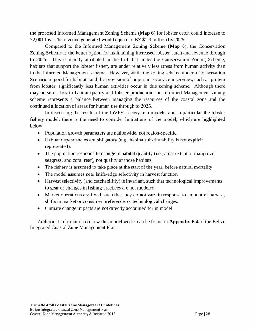
the proposed Informed Management Zoning Scheme (Map 6) for lobster catch could increase to
72,001 lbs. The revenue generated would equate to BZ $1.9 million by 2025.
Compared to the Informed Management Zoning Scheme (Map 6), the Conservation
Zoning Scheme is the better option for maintaining increased lobster catch and revenue through
to 2025. This is mainly attributed to the fact that under the Conservation Zoning Scheme,
habitats that support the lobster fishery are under relatively less stress from human activity than
in the Informed Management scheme. However, while the zoning scheme under a Conservation
Scenario is good for habitats and the provision of important ecosystem services, such as protein
from lobster, significantly less human activities occur in this zoning scheme. Although there
may be some loss to habitat quality and lobster production, the Informed Management zoning
scheme represents a balance between managing the resources of the coastal zone and the
continued allocation of areas for human use through to 2025.
In discussing the results of the InVEST ecosystem models, and in particular the lobster
fishery model, there is the need to consider limitations of the model, which are highlighted
below:
Population growth parameters are nationwide, not region-specific
Habitat dependencies are obligatory (e.g., habitat substitutability is not explicit
represented).
The population responds to change in habitat quantity (i.e., areal extent of mangrove,
seagrass, and coral reef), not quality of those habitats.
The fishery is assumed to take place at the start of the year, before natural mortality
The model assumes near knife-edge selectivity in harvest function
Harvest selectivity (and catchabilitiy) is invariant, such that technological improvements
to gear or changes in fishing practices are not modeled.
Market operations are fixed, such that they do not vary in response to amount of harvest,
shifts in market or consumer preference, or technological changes.
Climate change impacts are not directly accounted for in model
Additional information on how this model works can be found in Appendix B.4 of the Belize
Integrated Coastal Zone Management Plan.
Map 6: Informed Management Zoning Scheme for Fishing in the Turneffe Atoll Region
In the 1970’s and early 1980’s, gill and seine net fishing on, and around, Turneffe’s
backreef flats seriously diminished the atoll’s sport fishery. Attempts to stop the netting lead to
some violence but then a prolonged period without significant netting activity. Over the past 2 -
3 years netting has been re-initiated on, and adjacent to, the ocean-side bonefish flats, on the
seagrass flats in the central lagoon and in creeks frequented by tarpon. These activities are once
again having a significant impact on Turneffe’s sports fishing sector with areas now notably
devoid of resident schools of sport fish.
In 2009, Belize passed landmark legislation protecting bonefish, permit and tarpon based
on verification that these three species sustainably generate nearly $60 million dollars per year
for Belize and provide more than 1800 jobs. Net fishing, if left unchecked, could easily negate
Turneffe Atoll’s considerable financial contribution to Belize’s sport fishing sector.
The 2008 Fisheries Act, Chapter 10, Section 8 (1) indicates “In all areas outside the
barrier reef and within the radius of two miles of the mouth of the Belize River, Haulover Creek
and Sibun River, no person shall take fish by means of any beach seine, traps or as weir or stop
net.” Although this has not been literally interpreted or strictly enforced by the Fisheries
Department to date, doing so is a viable option for addressing this problem.
Due to limited resources and the remote location of Turneffe Atoll, it is widely
acknowledged that fisheries enforcement is not adequate and that unlawful fishing activities such
as illegal netting, poaching of protected aggregation sites, and harvesting of undersized conch
and lobster are commonplace. Turneffe’s commercial fishing sector, represented by the Belize
Fishermen Cooperative Association (BFCA), recognizes this as a major problem and they have
asked that enforcement be enhanced.
Personal security is a concern for the occupants of Turneffe Atoll including fishermen,
tourists and residential property owners. Security has clearly improved with the establishment of
the Calabash Coast Guard Station; however, the Coast Guard’s ability to patrol and respond to all
areas of the atoll is limited. In May, 2011, the Fisheries Department, Belize National Coast
Guard and Turneffe Atoll Trust signed an accord initiating regular patrols at Turneffe Atoll.
This represents a very positive step forward and the atoll’s three major resorts have committed
substantial resources for the effort.
The Fisheries Act, administered under the Fisheries Department, is the principal
governing legislation to regulate the fishing industry (Table 2), and is directly concerned with
maintaining sustainable fish stocks and protecting the marine and freshwater environments. In
order to protect the fisheries resources of the Turneffe Atoll and the traditional fishing rights of
fishing communities of the region, the following action steps are recommended, to complement
the existing Fisheries regulations and to enhance regional management of the fisheries resources.
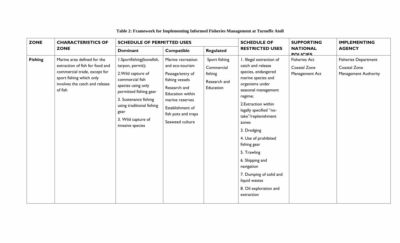
Table 2: Framework for Implementing Informed Fisheries Management at Turneffe Atoll
ZONE CHARACTERISTICS OF
ZONE
SCHEDULE OF PERMITTED USES SCHEDULE OF
RESTRICTED USES
SUPPORTING
NATIONAL
POLICIES
IMPLEMENTING
AGENCY Dominant Compatible Regulated
Fishing Marine area defined for the
extraction of fish for food and
commercial trade, except for
sport fishing which only
involves the catch and release
of fish
1.Sportfishing(bonefish,
tarpon, permit);
2.Wild capture of
commercial fish
species using only
permitted fishing gear
3. Sustenance fishing
using traditional fishing
gear
3. Wild capture of
invasive species
Marine recreation
and eco-tourism
Passage/entry of
fishing vessels
Research and
Education within
marine reserves
Establishment of
fish pots and traps
Seaweed culture
Sport fishing
Commercial
fishing
Research and
Education
1. Illegal extraction of
catch and release
species, endangered
marine species and
organisms under
seasonal management
regime;
2.Extraction within
legally specified “no-
take”/replenishment
zones
3. Dredging
4. Use of prohibited
fishing gear
5. Trawling
6. Shipping and
navigation
7. Dumping of solid and
liquid wastes
8. Oil exploration and
extraction
Fisheries Act
Coastal Zone
Management Act
Fisheries Department
Coastal Zone
Management Authority
Turneffe Atoll Coastal Zone Management Guidelines Belize Integrated Coastal Zone Management Plan Coastal Zone Management Authority & Institute 2015 Page | 32
Recommended Actions:
1. Manage Turneffe Atoll’s commercial fishery through the institution of modern
ecologically-based fisheries management techniques that sustain its economic, social and
ecological advantages of this fishery for future generations
2. Manage Turneffe Atoll’s sport fishery to sustain its economic, social, and job-related
advantages for Belize
3. Improve fisheries enforcement for the Atoll
4. Prevent development practices that damage commercial fishing and sport fishing habitats,
particularly the back-reef flats and sea grass beds
5. Disallow net fishing at Turneffe Atoll in compliance with enforcement of The Fisheries
Act, Chapter 10, Section 8 (1) and/or by other means
6. Provide traditional fishermen with security of tenure (leases) for existing fishing camps
7. Explore further cooperative public/private efforts to enhance enforcement and security at
Turneffe Atoll.
8. Improve the ability for fishing camps, resorts and other Turneffe Atoll locations to
communicate with the Belize Coast Guard for security purposes should be a priority.
9. Enhance the ability of the Belize Coast Guard to easily travel to all areas of Turneffe
Atoll, particularly the remote areas of the lagoon, should be enhanced.
10. Enlist local fishermen and resorts to help with monitoring and surveillance should be
promoted to enhance security.
Turneffe Atoll Coastal Zone Management Guidelines Belize Integrated Coastal Zone Management Plan Coastal Zone Management Authority & Institute 2015 Page | 33
6.2 Marine Tourism and Recreation
With a relatively healthy reef system, world-renowned back-reef flats and healthy
seagrass beds, in addition to a plethora of marine creatures, sport fish, marine mammals and
reptiles, Turneffe Atoll offers many attractions for nature-based tourism. The atoll’s tourism
industry is highly dependent upon healthy, intact marine and terrestrial environments. Turneffe
Atoll’s tourism industry should be directed towards low-impact, environmentally sensitive
tourism while cautiously avoiding destructive practices which would compromise the source of
the atoll’s attraction as a tourism destination. One such low impact activity includes nautical
tourism. However, proper in-depth planning and monitoring must take place before this are can
be used to further attract this type of tourism. This would include improvements in navigational
charts and demarcation of navigational routes.
There are currently three operational resorts that cater to sport fishing, Scuba diving,
snorkeling, and other ecotourism activities. Tours originating from Belize City, Ambergris Caye,
Caye Caulker and other locations also utilize Turneffe Atoll for sports fishing, diving and
snorkeling. Some cruise ship visitors also access the atoll. Some traditional fishermen have
expressed a desire to develop their fishing camps into small, guest houses offering the eco-
cultural experience of the fishermen. These guidelines support this type of development.
Results from InVEST’s Recreation and Tourism ecosystem service model suggest this
region will have a moderate tourist visitation by 2025 (Fig. 5, Appendix). Based on model
results, in 2010 approximately 106 thousand people currently visit this region, which generated
an annual revenue of BZ $12.3 million (Fig. 6, Appendix). In a Conservation Zoning Scheme,
In VEST results suggest that there would be a significant increase in tourist visits to
approximately 139 thousand, generating annual revenue of BZ $15.4 million. In a Development
Zoning Scheme, there would also be a significant increase in tourist visits to approximately 273
thousand generating annual revenue of BZ $30.2 million. In the proposed Informed
Management Zoning Scheme (Map 7), there model results again suggest that there would be a
significant increase in tourist visitation to Turneffe Atoll to approximately 177 thousand
generating annual revenue of BZ $30.4 million. The supporting framework for implementing the
Informed Management Zoning Scheme for marine recreation and tourism is outlined in Table 3.
In discussing the results of the InVEST ecosystem models, and in particular the
recreation model, there is the need to consider limitations of the model, which are highlighted
below:
The model assumes that people will respond similarly in the future to the attributes that
serve as predictors in the model. In other words, the assumption is that people in the
future will continue to be drawn to or repelled by a given attributes to the same degree as
currently.
Some of the attributes that are used as predictors of visitation are representations of areas
managed for particular human use (e.g. transportation). The model assumes that future
Turneffe Atoll Coastal Zone Management Guidelines Belize Integrated Coastal Zone Management Plan Coastal Zone Management Authority & Institute 2015 Page | 34
management of the zones and the type of activities that they represent are similar to
current.
Since there are no fine-scale data on the distribution of visitors to Belize, we use photo-
person-days as a proxy for the relative density of actual person-days of recreation across
the coastal zone.
Climate change impacts are not directly accounted for in model
Additional information on how this model works can be found in Appendix B.3 of the
Belize Integrated Coastal Zone Management Plan.
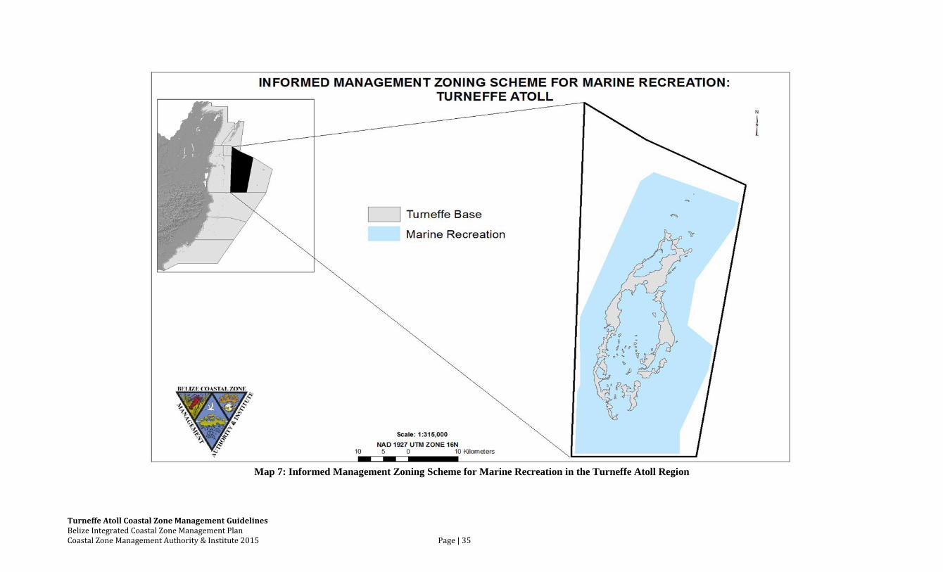
Turneffe Atoll Coastal Zone Management Guidelines Belize Integrated Coastal Zone Management Plan Coastal Zone Management Authority & Institute 2015 Page | 35
Map 7: Informed Management Zoning Scheme for Marine Recreation in the Turneffe Atoll Region
Turneffe Atoll Coastal Zone Management Guidelines Belize Integrated Coastal Zone Management Plan Coastal Zone Management Authority & Institute 2015 Page | 36
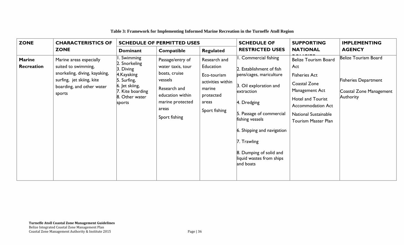
Table 3: Framework for Implementing Informed Marine Recreation in the Turneffe Atoll Region
ZONE CHARACTERISTICS OF
ZONE
SCHEDULE OF PERMITTED USES SCHEDULE OF
RESTRICTED USES
SUPPORTING
NATIONAL
POLICIES
IMPLEMENTING
AGENCY Dominant Compatible Regulated
Marine
Recreation
Marine areas especially
suited to swimming,
snorkeling, diving, kayaking,
surfing, jet skiing, kite
boarding, and other water
sports
1. Swimming
2. Snorkeling
3. Diving
4.Kayaking
5. Surfing,
6. Jet skiing,
7. Kite boarding
8. Other water
sports
Passage/entry of
water taxis, tour
boats, cruise
vessels
Research and
education within
marine protected
areas
Sport fishing
Research and
Education
Eco-tourism
activities within
marine
protected
areas
Sport fishing
1. Commercial fishing
2. Establishment of fish
pens/cages, mariculture
3. Oil exploration and
extraction
4. Dredging
5. Passage of commercial
fishing vessels
6. Shipping and navigation
7. Trawling
8. Dumping of solid and
liquid wastes from ships
and boats
Belize Tourism Board
Act
Fisheries Act
Coastal Zone
Management Act
Hotel and Tourist
Accommodation Act
National Sustainable
Tourism Master Plan
Belize Tourism Board
Fisheries Department
Coastal Zone Management
Authority
Turneffe Atoll Coastal Zone Management Guidelines Belize Integrated Coastal Zone Management Plan Coastal Zone Management Authority & Institute 2015 Page | 37
While the tourism industry generates much needed economic development, on both local and
national levels, it has been identified as also leading to reef damage, illegal camping, and litter. It is also
noticeable that it has had the effect of generating speculative, though not always well-informed,
development. The National Sustainable Tourism Master Plan (STP) recognizes that Belize’s barrier
reef, three atolls, and chain of reef islands are renowned internationally and form the basis of the
marine-based, nature tourism product of the country. As such, conservation of the Belize Barrier Reef is
key. The long-term objective for sustainable tourism development in area along the reef system,
including Turneffe Atoll, is to limit growth, allowing for only necessary improvements and small
enlargements for exiting homes, resorts, lodges and other tourism facilities. Preservation of the reef
system, marine habitats and ecosystem shall be the primary concern when assessing the need to make
improvements to the above-mentioned existing facilities.
Recommended Actions:
1. Promote low-impact, environmentally-sensitive, nature-based tourism with care to avoid
practices that destroy Turneffe Atoll’s sensitive and valuable habitats
2. Avoid high-impact, environmentally-destructive tourism development
3. All tourism facilities should meet BTB’s minimum standards, including disaster preparedness
and evacuation plans; and also meet the “Tourism and Recreation Best Practices Guidelines for
Coastal Areas in Belize” produced by CZMAI
4. BTB and/or DOE should not recommend or approve tourism facilities that do not conform to
these coastal zone management guidelines.
5. Tourism operators should assist Coast Guard and the Fisheries Department by providing
monitoring and communications assistance related to security and fisheries enforcement
6. Zoning schemes should give fishing camps the option to develop ‘guest houses’; promoting
opportunities for traditional users to benefit from tourism
7. The recommendations of the National Sustainable Tourism Master Plan for this region are to be
supported in order to encourage a long-tem sustainable tourism future
8. Implement the Recreation informed management zoning scheme for this region (Map 7)
Turneffe Atoll Coastal Zone Management Guidelines Belize Integrated Coastal Zone Management Plan Coastal Zone Management Authority & Institute 2015 Page | 38
6.3 Land-Use
The land use component of these management guidelines for the Turneffe Atoll region are based
on the carrying capacity of the environment, combined with the existing and projected types of land
tenure patterns and use activities. The development suitability, current and future development trends,
existing land use and property rights, socio-economic and other relevant data are a critical for
determining the land-use classification within the Belize coastal zone. It is also important that these
coastal zone management guidelines maintain some flexibility to enable a response to the ever changing
socio-economic and physical environment.
The Turneffe Atoll consists of approximately 115 square kilometers which is made up of a mix
of inundated mangrove swamp and low-lying land with an elevation up to a few feet above sea level.
The cayes, some of them larger than 20 square kilometers, fringe an expansive lagoon system reaching a
width of 8 kilometers and a length of 21 kilometers. Turneffe Atoll’s cayes are characterized by
approximately 77 vegetation types, reflecting the topography of the land. The higher land is generally
covered by littoral forest, palmetto, broken palmetto thicket and some coconut; the inundated areas with
high, medium and low mangrove.
The location of significant structures (lodging quarters, restaurants and bars) over the water is
inherently adverse to the aesthetics of Turneffe Atoll. Moreover, it causes navigational hazards and sets
an alarming precedent, which would likely become very difficult to control. For these reasons, many
coastal villages with local planning authority have disallowed this practice. Additionally, waste
management is difficult to control with over-the-water development; and, although ‘cleaner
technologies’ may initially be permitted, any leak or malfunction could cause immediate detrimental
effects to the marine environment. Furthermore, Turneffe Atoll is exceptionally vulnerable to
hurricanes making over-the-water construction infeasible.
The National Sustainable Tourism Master Plan for Belize (STP) 2030 recognizes that the
Turneffe Atoll is one of those key areas along the Belize Barrier Reef that contain highly sensitive
natural ecosystems, whose ecological integrity needs to be maintained. As such, the Plan recommends a
model of development for Turneffe Atoll region that constrains and consolidates growth, only allowing
for necessary improvements and small enlargements for exiting homes, resorts, lodges and other tourism
facilities. These small enlargements on exiting facilities will contribute to a maximum growth allocation
of a total of 37 new hotel rooms for areas along the entire reef system by 2030. The density proposed for
the extension of exiting resorts is “very low density”, which includes 4 units/acre-10 units/hectare. This
model should help achieve the long-term objective for sustainable tourism development along the reef
system. Improvement and expansion to the above-mentioned existing facilities at Turneffe Atoll will be
subject to the environmental clearance process coordinated by the Department of the Environment and
National Environmental Appraisal Committee (NEAC).-
In the case of privately held undeveloped lands, the development standards presented within these
guidelines presents the most sustainable and appropriate future land use. Although the CZMAI recognizes the
right of the landowner to develop their land in any matter they see fit there must be measures in place to steer
future development in order to ensure sustained ecosystem services. Therefore, in the case of these lands, if there
Turneffe Atoll Coastal Zone Management Guidelines Belize Integrated Coastal Zone Management Plan Coastal Zone Management Authority & Institute 2015 Page | 39
is no development activity within the first five (5) years of the passage of this planning document then all future
development activities, after the time period, MUST follow development standards as outlined within this
coastal development guideline.
Turneffe Atoll Coastal Zone Management Guidelines Belize Integrated Coastal Zone Management Plan Coastal Zone Management Authority & Institute 2015 Page | 40
6.3.1 Cayes Development Standards
Development on cayes and atolls require specific building standards since these areas are in close
proximity to important sensitive habitats such as sea grass beds, mangroves and coral reefs. Ad hoc or
uncontrolled development in these areas can have severe negative effects on surrounding ecosystems.
For example the construction and proliferation of piers can cause destruction of the beach, sea grass bed
and seabed and sedimentation, particularly if they are positioned on the windward side. Furthermore,
the movement of debris during storms from buildings constructed on piers can be dangerous.
Sustainable development is crucial in maintaining our natural resources and the benefits that Belizeans
receive from them. Proper planning is required for this to be achieved.
By 2004, CZMAI had produced a set of Cayes Development Guidelines for the cayes within nine
coastal planning regions (Map 1). These development guidelines were produced in consultation with
stakeholders from each planning region along with technical input from government relevant agencies.
Within each guidelines document, land use classes were developed along with accompanying standards
for the varying degrees of development that can occur on each caye. Use classes were also assigned to
each caye based on development suitability assessments. The use class categories developed ranged
from residential to conservation, and commercial to research and education, representing the various
degrees of allowable development intensities on cayes.
The original cayes development guidelines for this region identified 94 ‘development sites’ and
specified the type of land use, lot size, building density, means of utility supply and other relevant
performance standards for each site. Most of these are expressed as minimum or maximum
requirements, allowing for flexibility between these margins. It is intended that development should
take place only on these sites; the remainder of the land, whether it is high or low, should be kept, at
least until further review, in reserve. A presumption against development should be exercised on all
areas outside the development sites.
Each development site is given a series of performance standards, ranging from the size of the
site to the means of waste disposal. However, it should be noticed that the great majority of sites are
given two ‘land use’ options: the primary being the most recommended, the secondary being considered
as suitable as a development option, but only so long as the primary ‘land use’ is utilized. The primary
land uses identified for the cayes on the atoll include fish camps, conservation, research and education,
residential and resort/guesthouses. These standards are found in the development sites table below
(Table 4) and correspond with the proposed land use maps for the cayes (Maps 8, 9, 10).
Turneffe Atoll Coastal Zone Management Guidelines Belize Integrated Coastal Zone Management Plan Coastal Zone Management Authority & Institute 2015 Page | 41
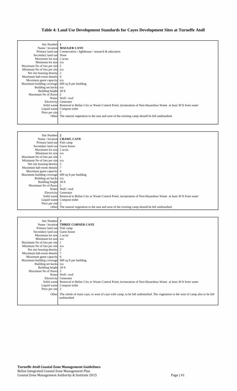
Table 4: Land Use Development Standards for Cayes Development Sites at Turneffe Atoll
Site Number 1 Name / location MAUGER CAYE
Primary land use Conservation / lighthouse / research & education Secondary land use None Maximum lot size 2 acres Minimum lot size n/a
Maximum No of lots per site 2 Minimum No of lots per site n/a
Net site housing density 2 Maximum hab-room density 4
Maximum guest capacity n/a Maximum building coverage 600 sq ft per building
Building set backs n/a Building height 28 ft
Maximum No of floors 2 Water Well / roof
Electricity Generator Solid waste Removal to Belize City or Waste Control Point; incineration of Non-Hazardous Waste at least 30 ft from water
Liquid waste Compost toilet Piers per site 2
Other The natural vegetation to the east and west of the existing camp should be left undisturbed.
Site Number 2 Name / location CRAWL CAYE
Primary land use Fish camp Secondary land use Guest house Maximum lot size 2 acres Minimum lot size n/a
Maximum No of lots per site 1 Minimum No of lots per site n/a
Net site housing density 2 Maximum hab-room density 7
Maximum guest capacity 4 Maximum building coverage 600 sq ft per building
Building set backs n/a Building height 28 ft
Maximum No of floors 2 Water Well / roof
Electricity Generator Solid waste Removal to Belize City or Waste Control Point; incineration of Non-Hazardous Waste at least 30 ft from water
Liquid waste Compost toilet Piers per site 2
Other The natural vegetation to the east and west of the existing camp should be left undisturbed.
Site Number 3 Name / location THREE CORNER CAYE
Primary land use Fish camp Secondary land use Guest house Maximum lot size 2 acres Minimum lot size n/a
Maximum No of lots per site 1 Minimum No of lots per site n/a
Net site housing density 2 Maximum hab-room density 7
Maximum guest capacity 6 Maximum building coverage 600 sq ft per building
Building set backs n/a Building height 28 ft
Maximum No of floors 2 Water Well / roof
Electricity Generator Solid waste Removal to Belize City or Waste Control Point; incineration of Non-Hazardous Waste at least 30 ft from water
Liquid waste Compost toilet Piers per site 2
Other The whole of main caye, to west of caye with camp, to be left undisturbed. The vegetation to the west of camp also to be left undisturbed
Turneffe Atoll Coastal Zone Management Guidelines Belize Integrated Coastal Zone Management Plan Coastal Zone Management Authority & Institute 2015 Page | 42
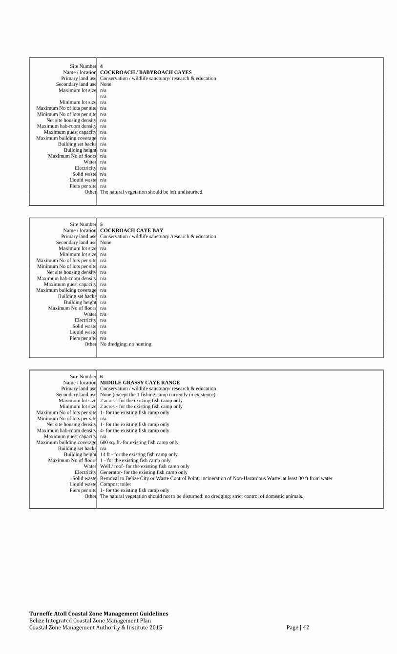
Site Number 4
Name / location COCKROACH / BABYROACH CAYES
Primary land use Conservation / wildlife sanctuary/ research & education
Secondary land use None
Maximum lot size n/a
Minimum lot size n/a
n/a
Maximum No of lots per site n/a
Minimum No of lots per site n/a
Net site housing density n/a
Maximum hab-room density n/a
Maximum guest capacity n/a
Maximum building coverage n/a
Building set backs n/a
Building height n/a
Maximum No of floors n/a
Water n/a
Electricity n/a
Solid waste n/a
Liquid waste n/a
Piers per site n/a
Other The natural vegetation should be left undisturbed.
Site Number 5
Name / location COCKROACH CAYE BAY
Primary land use Conservation / wildlife sanctuary /research & education
Secondary land use None
Maximum lot size n/a
Minimum lot size n/a
Maximum No of lots per site n/a
Minimum No of lots per site n/a
Net site housing density n/a
Maximum hab-room density n/a
Maximum guest capacity n/a
Maximum building coverage n/a
Building set backs n/a
Building height n/a
Maximum No of floors n/a
Water n/a
Electricity n/a
Solid waste n/a
Liquid waste n/a
Piers per site n/a
Other No dredging; no hunting.
Site Number 6
Name / location MIDDLE GRASSY CAYE RANGE
Primary land use Conservation / wildlife sanctuary/ research & education
Secondary land use None (except the 1 fishing camp currently in existence)
Maximum lot size 2 acres - for the existing fish camp only
Minimum lot size 2 acres - for the existing fish camp only
Maximum No of lots per site 1- for the existing fish camp only
Minimum No of lots per site n/a
Net site housing density 1- for the existing fish camp only
Maximum hab-room density 4- for the existing fish camp only
Maximum guest capacity n/a
Maximum building coverage 600 sq. ft.-for existing fish camp only
Building set backs n/a
Building height 14 ft - for the existing fish camp only
Maximum No of floors 1 - for the existing fish camp only
Water Well / roof- for the existing fish camp only
Electricity Generator- for the existing fish camp only
Solid waste Removal to Belize City or Waste Control Point; incineration of Non-Hazardous Waste at least 30 ft from water
Liquid waste Compost toilet
Piers per site 1- for the existing fish camp only
Other The natural vegetation should not to be disturbed; no dredging; strict control of domestic animals.
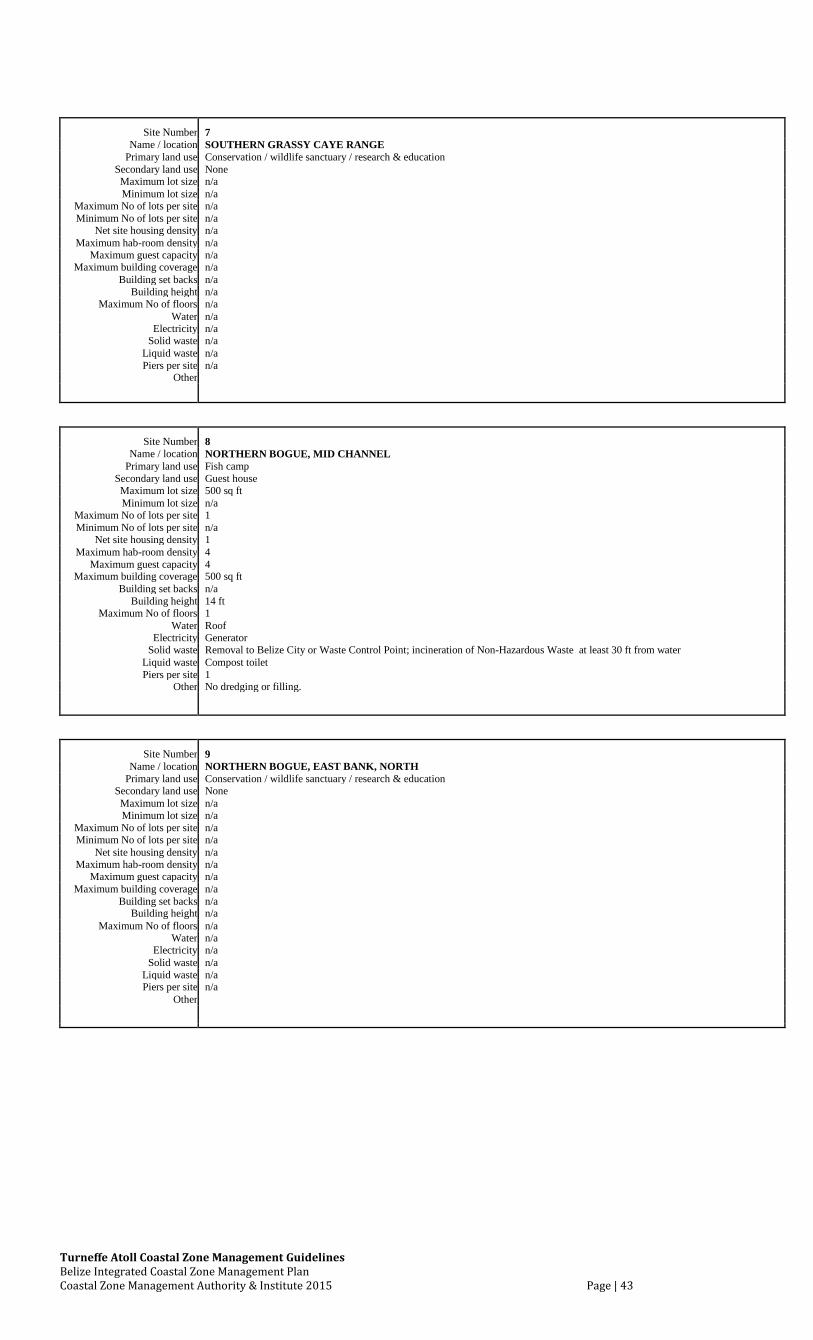
Turneffe Atoll Coastal Zone Management Guidelines Belize Integrated Coastal Zone Management Plan Coastal Zone Management Authority & Institute 2015 Page | 43
Site Number 7 Name / location SOUTHERN GRASSY CAYE RANGE
Primary land use Conservation / wildlife sanctuary / research & education Secondary land use None Maximum lot size n/a Minimum lot size n/a
Maximum No of lots per site n/a Minimum No of lots per site n/a
Net site housing density n/a Maximum hab-room density n/a
Maximum guest capacity n/a Maximum building coverage n/a
Building set backs n/a Building height n/a
Maximum No of floors n/a Water n/a
Electricity n/a Solid waste n/a
Liquid waste n/a Piers per site n/a
Other
Site Number 8 Name / location NORTHERN BOGUE, MID CHANNEL
Primary land use Fish camp Secondary land use Guest house Maximum lot size 500 sq ft Minimum lot size n/a
Maximum No of lots per site 1 Minimum No of lots per site n/a
Net site housing density 1 Maximum hab-room density 4
Maximum guest capacity 4 Maximum building coverage 500 sq ft
Building set backs n/a Building height 14 ft
Maximum No of floors 1 Water Roof
Electricity Generator Solid waste Removal to Belize City or Waste Control Point; incineration of Non-Hazardous Waste at least 30 ft from water
Liquid waste Compost toilet Piers per site 1
Other No dredging or filling.
Site Number 9 Name / location NORTHERN BOGUE, EAST BANK, NORTH
Primary land use Conservation / wildlife sanctuary / research & education Secondary land use None Maximum lot size n/a Minimum lot size n/a
Maximum No of lots per site n/a Minimum No of lots per site n/a
Net site housing density n/a Maximum hab-room density n/a
Maximum guest capacity n/a Maximum building coverage n/a
Building set backs n/a Building height n/a
Maximum No of floors n/a Water n/a
Electricity n/a Solid waste n/a
Liquid waste n/a Piers per site n/a
Other
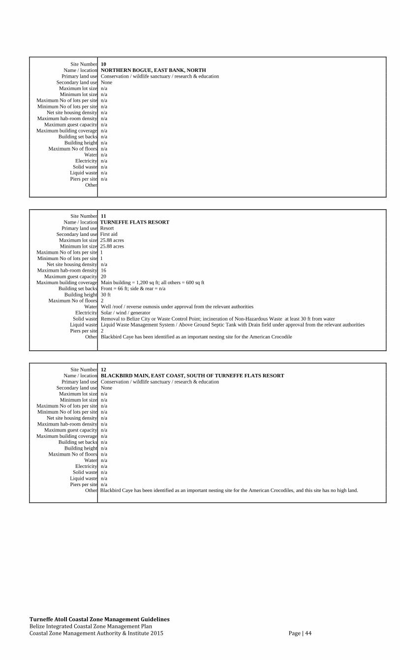
Turneffe Atoll Coastal Zone Management Guidelines Belize Integrated Coastal Zone Management Plan Coastal Zone Management Authority & Institute 2015 Page | 44
Site Number 10
Name / location NORTHERN BOGUE, EAST BANK, NORTH
Primary land use Conservation / wildlife sanctuary / research & education
Secondary land use None
Maximum lot size n/a
Minimum lot size n/a
Maximum No of lots per site n/a
Minimum No of lots per site n/a
Net site housing density n/a
Maximum hab-room density n/a
Maximum guest capacity n/a
Maximum building coverage n/a
Building set backs n/a
Building height n/a
Maximum No of floors n/a
Water n/a
Electricity n/a
Solid waste n/a
Liquid waste n/a
Piers per site n/a
Other
Site Number 11
Name / location TURNEFFE FLATS RESORT
Primary land use Resort
Secondary land use First aid
Maximum lot size 25.88 acres
Minimum lot size 25.88 acres
Maximum No of lots per site 1
Minimum No of lots per site 1
Net site housing density n/a
Maximum hab-room density 16
Maximum guest capacity 20
Maximum building coverage Main building = 1,200 sq ft; all others = 600 sq ft
Building set backs Front = 66 ft; side & rear = n/a
Building height 30 ft
Maximum No of floors 2
Water Well /roof / reverse osmosis under approval from the relevant authorities
Electricity Solar / wind / generator
Solid waste Removal to Belize City or Waste Control Point; incineration of Non-Hazardous Waste at least 30 ft from water
Liquid waste Liquid Waste Management System / Above Ground Septic Tank with Drain field under approval from the relevant authorities
Piers per site 2
Other Blackbird Caye has been identified as an important nesting site for the American Crocodile
Site Number 12
Name / location BLACKBIRD MAIN, EAST COAST, SOUTH OF TURNEFFE FLATS RESORT
Primary land use Conservation / wildlife sanctuary / research & education
Secondary land use None
Maximum lot size n/a
Minimum lot size n/a
Maximum No of lots per site n/a
Minimum No of lots per site n/a
Net site housing density n/a
Maximum hab-room density n/a
Maximum guest capacity n/a
Maximum building coverage n/a
Building set backs n/a
Building height n/a
Maximum No of floors n/a
Water n/a
Electricity n/a
Solid waste n/a
Liquid waste n/a
Piers per site n/a
Other Blackbird Caye has been identified as an important nesting site for the American Crocodiles, and this site has no high land.
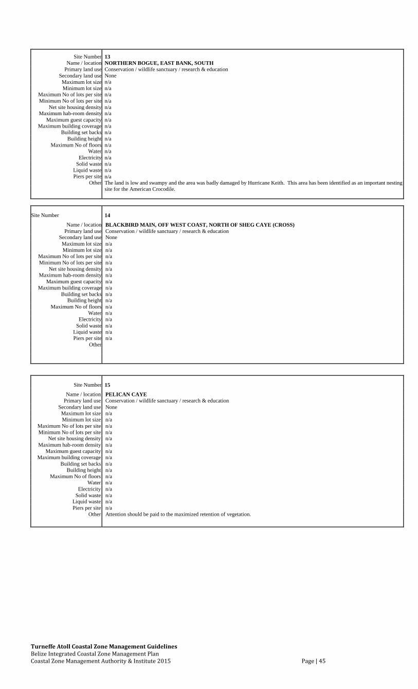
Turneffe Atoll Coastal Zone Management Guidelines Belize Integrated Coastal Zone Management Plan Coastal Zone Management Authority & Institute 2015 Page | 45
Site Number 13
Name / location NORTHERN BOGUE, EAST BANK, SOUTH
Primary land use Conservation / wildlife sanctuary / research & education
Secondary land use None n/a
Maximum lot size
Minimum lot size n/a
Maximum No of lots per site n/a
Minimum No of lots per site n/a
Net site housing density n/a
Maximum hab-room density n/a
Maximum guest capacity n/a
Maximum building coverage n/a
Building set backs n/a
Building height n/a
Maximum No of floors n/a
Water n/a
Electricity n/a
Solid waste n/a
Liquid waste n/a
Piers per site n/a
Other The land is low and swampy and the area was badly damaged by Hurricane Keith. This area has been identified as an important nesting
site for the American Crocodile.
Site Number 14
Name / location BLACKBIRD MAIN, OFF WEST COAST, NORTH OF SHEG CAYE (CROSS)
Primary land use Conservation / wildlife sanctuary / research & education
Secondary land use None
Maximum lot size n/a
Minimum lot size n/a
Maximum No of lots per site n/a
Minimum No of lots per site n/a
Net site housing density n/a
Maximum hab-room density n/a
Maximum guest capacity n/a
Maximum building coverage n/a
Building set backs n/a
Building height n/a
Maximum No of floors n/a
Water n/a
Electricity n/a
Solid waste n/a
Liquid waste n/a
Piers per site n/a
Other
Site Number 15
Name / location PELICAN CAYE
Primary land use Conservation / wildlife sanctuary / research & education
Secondary land use None
Maximum lot size n/a
Minimum lot size n/a
Maximum No of lots per site n/a
Minimum No of lots per site n/a
Net site housing density n/a
Maximum hab-room density n/a
Maximum guest capacity n/a
Maximum building coverage n/a
Building set backs n/a
Building height n/a
Maximum No of floors n/a
Water n/a
Electricity n/a
Solid waste n/a
Liquid waste n/a
Piers per site n/a
Other Attention should be paid to the maximized retention of vegetation.
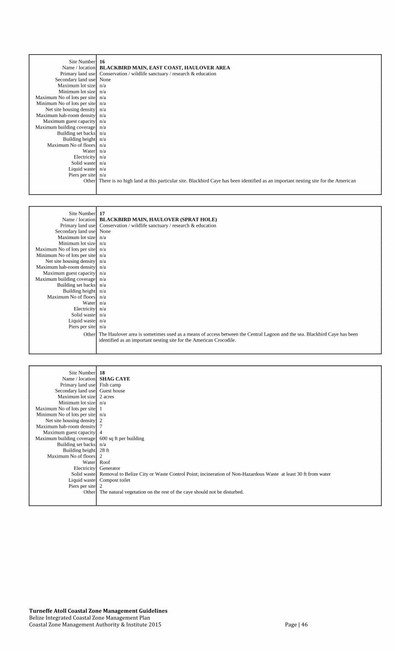
Turneffe Atoll Coastal Zone Management Guidelines Belize Integrated Coastal Zone Management Plan Coastal Zone Management Authority & Institute 2015 Page | 46
Site Number 16 Name / location BLACKBIRD MAIN, EAST COAST, HAULOVER AREA
Primary land use Conservation / wildlife sanctuary / research & education Secondary land use None Maximum lot size n/a Minimum lot size n/a
Maximum No of lots per site n/a Minimum No of lots per site n/a
Net site housing density n/a Maximum hab-room density n/a
Maximum guest capacity n/a Maximum building coverage n/a
Building set backs n/a Building height n/a
Maximum No of floors n/a Water n/a
Electricity n/a Solid waste n/a
Liquid waste n/a Piers per site n/a
Other There is no high land at this particular site. Blackbird Caye has been identified as an important nesting site for the American
Site Number 17 Name / location BLACKBIRD MAIN, HAULOVER (SPRAT HOLE)
Primary land use Conservation / wildlife sanctuary / research & education Secondary land use None Maximum lot size n/a Minimum lot size n/a
Maximum No of lots per site n/a Minimum No of lots per site n/a
Net site housing density n/a Maximum hab-room density n/a
Maximum guest capacity n/a Maximum building coverage n/a
Building set backs n/a Building height n/a
Maximum No of floors n/a Water n/a
Electricity n/a Solid waste n/a
Liquid waste n/a Piers per site n/a
Other The Haulover area is sometimes used as a means of access between the Central Lagoon and the sea. Blackbird Caye has been
identified as an important nesting site for the American Crocodile.
Site Number 18 Name / location SHAG CAYE
Primary land use Fish camp Secondary land use Guest house Maximum lot size 2 acres Minimum lot size n/a
Maximum No of lots per site 1 Minimum No of lots per site n/a
Net site housing density 2 Maximum hab-room density 7
Maximum guest capacity 4 Maximum building coverage 600 sq ft per building
Building set backs n/a Building height 28 ft
Maximum No of floors 2 Water Roof
Electricity Generator Solid waste Removal to Belize City or Waste Control Point; incineration of Non-Hazardous Waste at least 30 ft from water
Liquid waste Compost toilet Piers per site 2
Other The natural vegetation on the rest of the caye should not be disturbed.
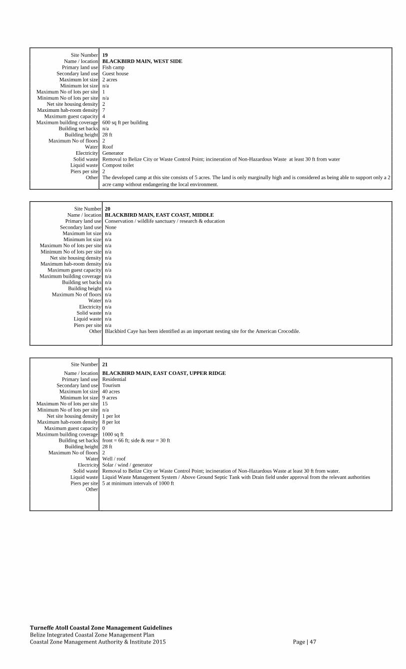
Turneffe Atoll Coastal Zone Management Guidelines Belize Integrated Coastal Zone Management Plan Coastal Zone Management Authority & Institute 2015 Page | 47
Site Number 19 Name / location BLACKBIRD MAIN, WEST SIDE
Primary land use Fish camp Secondary land use Guest house Maximum lot size 2 acres Minimum lot size n/a
Maximum No of lots per site 1 Minimum No of lots per site n/a
Net site housing density 2 Maximum hab-room density 7
Maximum guest capacity 4 Maximum building coverage 600 sq ft per building
Building set backs n/a Building height 28 ft
Maximum No of floors 2 Water Roof
Electricity Generator Solid waste Removal to Belize City or Waste Control Point; incineration of Non-Hazardous Waste at least 30 ft from water
Liquid waste Compost toilet Piers per site 2
Other The developed camp at this site consists of 5 acres. The land is only marginally high and is considered as being able to support only a 2 acre camp without endangering the local environment.
Site Number 20
Name / location BLACKBIRD MAIN, EAST COAST, MIDDLE
Primary land use Conservation / wildlife sanctuary / research & education
Secondary land use None
Maximum lot size n/a
Minimum lot size n/a
Maximum No of lots per site n/a
Minimum No of lots per site n/a
Net site housing density n/a
Maximum hab-room density n/a
Maximum guest capacity n/a
Maximum building coverage n/a
Building set backs n/a
Building height n/a
Maximum No of floors n/a
Water n/a
Electricity n/a
Solid waste n/a
Liquid waste n/a
Piers per site n/a
Other Blackbird Caye has been identified as an important nesting site for the American Crocodile.
Site Number 21
Name / location BLACKBIRD MAIN, EAST COAST, UPPER RIDGE
Primary land use Residential
Secondary land use Tourism
Maximum lot size 40 acres
Minimum lot size 9 acres
Maximum No of lots per site 15
Minimum No of lots per site n/a
Net site housing density 1 per lot
Maximum hab-room density 8 per lot
Maximum guest capacity 0
Maximum building coverage 1000 sq ft
Building set backs front = 66 ft; side & rear = 30 ft
Building height 28 ft
Maximum No of floors 2
Water Well / roof
Electricity Solar / wind / generator
Solid waste Removal to Belize City or Waste Control Point; incineration of Non-Hazardous Waste at least 30 ft from water.
Liquid waste Liquid Waste Management System / Above Ground Septic Tank with Drain field under approval from the relevant authorities
Piers per site 5 at minimum intervals of 1000 ft
Other
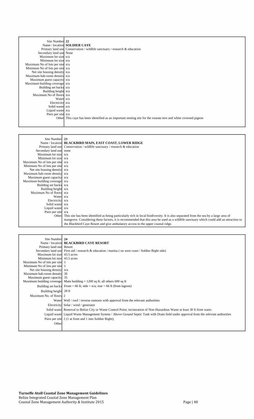
Turneffe Atoll Coastal Zone Management Guidelines Belize Integrated Coastal Zone Management Plan Coastal Zone Management Authority & Institute 2015 Page | 48
Site Number 22 Name / location SOLDIER CAYE
Primary land use Conservation / wildlife sanctuary / research & education Secondary land use None Maximum lot size n/a Minimum lot size n/a
Maximum No of lots per site n/a Minimum No of lots per site n/a
Net site housing density n/a Maximum hab-room density n/a
Maximum guest capacity n/a Maximum building coverage n/a
Building set backs n/a Building height n/a
Maximum No of floors n/a Water n/a
Electricity n/a Solid waste n/a
Liquid waste n/a Piers per site n/a
Other This caye has been identified as an important nesting site for the roseate tern and white crowned pigeon
Site Number 23 Name / location BLACKBIRD MAIN, EAST COAST, LOWER RIDGE
Primary land use Conservation / wildlife sanctuary / research & education Secondary land use none Maximum lot size n/a Minimum lot size n/a
Maximum No of lots per site n/a Minimum No of lots per site n/a
Net site housing density n/a Maximum hab-room density n/a
Maximum guest capacity n/a Maximum building coverage n/a
Building set backs n/a Building height n/a
Maximum No of floors n/a Water n/a
Electricity n/a Solid waste n/a
Liquid waste n/a Piers per site n/a
Other This site has been identified as being particularly rich in local biodiversity. It is also separated from the sea by a large area of mangrove. Considering these factors, it is recommended that this area be used as a wildlife sanctuary which could add an attraction to the Blackbird Caye Resort and give ambulatory access to the upper coastal ridge.
Site Number 24
Name / location BLACKBIRD CAYE RESORT
Primary land use Resort
Secondary land use First aid / research & education / marina ( on west coast / Soldier Bight side)
Maximum lot size 43.5 acres
Minimum lot size 43.5 acres
Maximum No of lots per site 1
Minimum No of lots per site 1
Net site housing density n/a
Maximum hab-room density 30
Maximum guest capacity 35
Maximum building coverage Main building = 1200 sq ft; all others 600 sq ft
Building set backs Front = 66 ft; side = n/a; rear = 66 ft (from lagoon)
Building height 28 ft
Maximum No. of floors 2
Water Well / roof / reverse osmosis with approval from the relevant authorities
Electricity Solar / wind / generator
Solid waste Removal to Belize City or Waste Control Point; incineration of Non-Hazardous Waste at least 30 ft from water.
Liquid waste Liquid Waste Management System / Above Ground Septic Tank with Drain field under approval from the relevant authorities
Piers per site 2 (1 at front and 1 into Soldier Bight);
Other
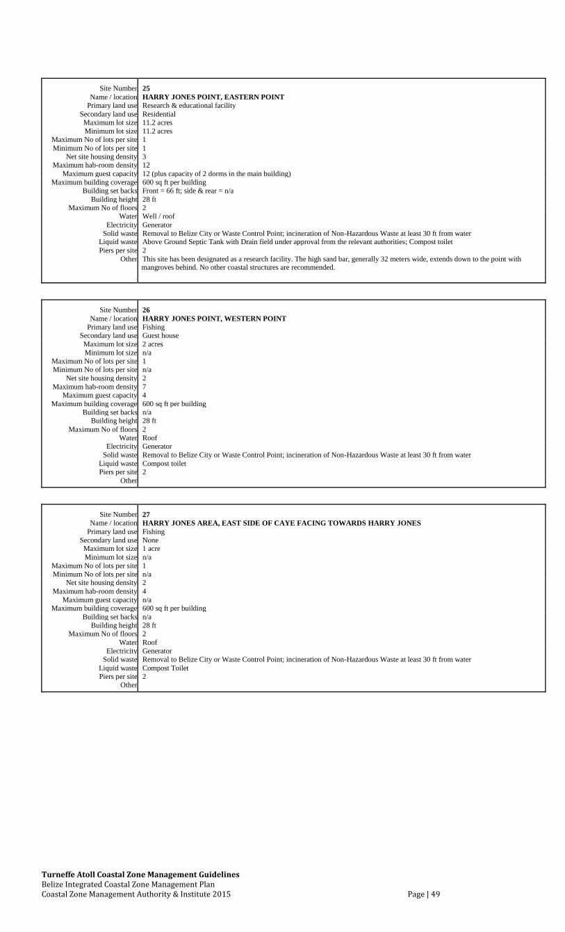
Turneffe Atoll Coastal Zone Management Guidelines Belize Integrated Coastal Zone Management Plan Coastal Zone Management Authority & Institute 2015 Page | 49
Site Number 25 Name / location HARRY JONES POINT, EASTERN POINT
Primary land use Research & educational facility Secondary land use Residential Maximum lot size 11.2 acres Minimum lot size 11.2 acres
Maximum No of lots per site 1 Minimum No of lots per site 1
Net site housing density 3 Maximum hab-room density 12
Maximum guest capacity 12 (plus capacity of 2 dorms in the main building) Maximum building coverage 600 sq ft per building
Building set backs Front = 66 ft; side & rear = n/a Building height 28 ft
Maximum No of floors 2 Water Well / roof
Electricity Generator Solid waste Removal to Belize City or Waste Control Point; incineration of Non-Hazardous Waste at least 30 ft from water
Liquid waste Above Ground Septic Tank with Drain field under approval from the relevant authorities; Compost toilet Piers per site 2
Other This site has been designated as a research facility. The high sand bar, generally 32 meters wide, extends down to the point with
mangroves behind. No other coastal structures are recommended.
Site Number 26 Name / location HARRY JONES POINT, WESTERN POINT
Primary land use Fishing Secondary land use Guest house Maximum lot size 2 acres Minimum lot size n/a
Maximum No of lots per site 1 Minimum No of lots per site n/a
Net site housing density 2 Maximum hab-room density 7
Maximum guest capacity 4 Maximum building coverage 600 sq ft per building
Building set backs n/a Building height 28 ft
Maximum No of floors 2 Water Roof
Electricity Generator Solid waste Removal to Belize City or Waste Control Point; incineration of Non-Hazardous Waste at least 30 ft from water
Liquid waste Compost toilet Piers per site 2
Other
Site Number 27 Name / location HARRY JONES AREA, EAST SIDE OF CAYE FACING TOWARDS HARRY JONES
Primary land use Fishing Secondary land use None Maximum lot size 1 acre Minimum lot size n/a
Maximum No of lots per site 1 Minimum No of lots per site n/a
Net site housing density 2 Maximum hab-room density 4
Maximum guest capacity n/a Maximum building coverage 600 sq ft per building
Building set backs n/a Building height 28 ft
Maximum No of floors 2 Water Roof
Electricity Generator Solid waste Removal to Belize City or Waste Control Point; incineration of Non-Hazardous Waste at least 30 ft from water
Liquid waste Compost Toilet Piers per site 2
Other
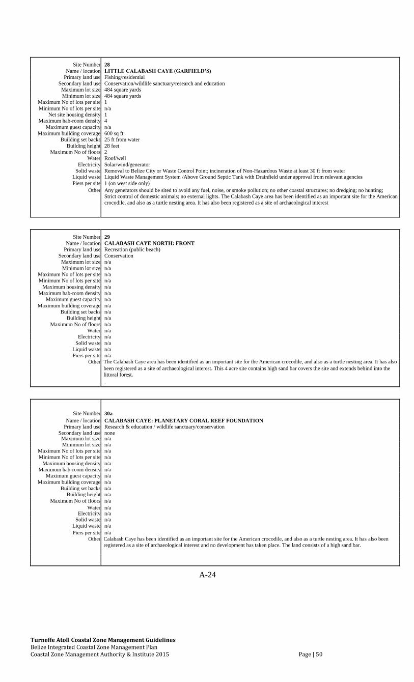
Turneffe Atoll Coastal Zone Management Guidelines Belize Integrated Coastal Zone Management Plan Coastal Zone Management Authority & Institute 2015 Page | 50
Site Number 28
Name / location LITTLE CALABASH CAYE (GARFIELD’S)
Primary land use Fishing/residential
Secondary land use Conservation/wildlife sanctuary/research and education
Maximum lot size 484 square yards
Minimum lot size 484 square yards
Maximum No of lots per site 1
Minimum No of lots per site n/a
Net site housing density 1
Maximum hab-room density 4
Maximum guest capacity n/a
Maximum building coverage 600 sq ft
Building set backs 25 ft from water
Building height 28 feet
Maximum No of floors 2
Water Roof/well
Electricity Solar/wind/generator
Solid waste Removal to Belize City or Waste Control Point; incineration of Non-Hazardous Waste at least 30 ft from water
Liquid waste Liquid Waste Management System /Above Ground Septic Tank with Drainfield under approval from relevant agencies
Piers per site 1 (on west side only)
Other Any generators should be sited to avoid any fuel, noise, or smoke pollution; no other coastal structures; no dredging; no hunting;
Strict control of domestic animals; no external lights. The Calabash Caye area has been identified as an important site for the American
crocodile, and also as a turtle nesting area. It has also been registered as a site of archaeological interest
Site Number 29 Name / location CALABASH CAYE NORTH: FRONT
Primary land use Recreation (public beach) Secondary land use Conservation Maximum lot size n/a Minimum lot size n/a
Maximum No of lots per site n/a Minimum No of lots per site n/a
Maximum housing density n/a Maximum hab-room density n/a
Maximum guest capacity n/a Maximum building coverage n/a
Building set backs n/a Building height n/a
Maximum No of floors n/a Water n/a
Electricity n/a Solid waste n/a
Liquid waste n/a Piers per site n/a
Other The Calabash Caye area has been identified as an important site for the American crocodile, and also as a turtle nesting area. It has also
been registered as a site of archaeological interest. This 4 acre site contains high sand bar covers the site and extends behind into the
littoral forest.
.
Site Number 30a Name / location CALABASH CAYE: PLANETARY CORAL REEF FOUNDATION
Primary land use Research & education / wildlife sanctuary/conservation Secondary land use none Maximum lot size n/a Minimum lot size n/a
Maximum No of lots per site n/a Minimum No of lots per site n/a
Maximum housing density n/a Maximum hab-room density n/a
Maximum guest capacity n/a Maximum building coverage n/a
Building set backs n/a Building height n/a
Maximum No of floors n/a Water n/a
Electricity n/a Solid waste n/a
Liquid waste n/a Piers per site n/a
Other Calabash Caye has been identified as an important site for the American crocodile, and also as a turtle nesting area. It has also been registered as a site of archaeological interest and no development has taken place. The land consists of a high sand bar.
A-24
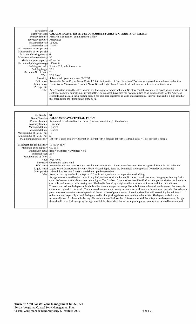
Turneffe Atoll Coastal Zone Management Guidelines Belize Integrated Coastal Zone Management Plan Coastal Zone Management Authority & Institute 2015 Page | 51
Site Number 30b Name / location CALABASH CAYE: INSTITUTE OF MARINE STUDIES (UNIVERSITY OF BELIZE)
Primary land use Research & education / administration facility Secondary land use Residential Maximum lot size 12 acres Minimum lot size 7 acres
Maximum No of lots per site 2 Minimum No of lots per site 1
Maximum housing density 6 Maximum hab-room density 30
Maximum guest capacity 40 per site Maximum building coverage 1200 sq ft
Building set backs Front = 66 ft; side & rear = n/a Building height 28 ft
Maximum No of floors 2 Water Well / roof
Electricity Solar / wind / generator / sites 30/32/33 Solid waste Removal to Belize City or Waste Control Point / incineration of Non Hazardous Waste under approval from relevant authorities
Liquid waste Liquid Waste Management System / Above Ground Septic Tank &Drain field under approval from relevant authorities Piers per site 1
Other Any generators should be sited to avoid any fuel, noise or smoke pollution. No other coastal structures, no dredging, no hunting, strict
control of domestic animals, no external lights. The Calabash Caye area has been identified as an important site for the American
crocodile, and also as a turtle nesting area. It has also been registered as a site of archaeological interest. The land is a high sand bar
that extends into the littoral forest at the back.
Site Number 31
Name / location CALABASH CAYE CENTRAL, FRONT
Primary land use Residential / residential tourism /resort (one only on a lot larger than 5 acres)
Secondary land use Fish camp
Maximum lot size 15 acres
Minimum lot size 15 acres
Maximum No of lots per site 10
Minimum No of lots per site 5
Maximum housing density Lot with 5 acres or more = 2 per lot or 1 per lot with 4 cabanas; lot with less than 5 acres = 1 per lot with 1 cabana
Maximum hab-room density
10 (resort only)
Maximum guest capacity 600 sq ft
Building set backs front = 66 ft; side = 30 ft; rear = n/a
Building height 28 ft
Maximum No of floors 2
Water Well / roof
Electricity Generator / solar / wind
Solid waste Removal to Belize City or Waste Control Point / incineration of Non Hazardous Waste under approval from relevant authorities
Liquid waste Liquid Waste Management System / Above Ground Septic Tank and Drain field under approval from relevant authorities
Piers per site 1 though lots less than 5 acres should share 1 per between them
Other Access to the lagoon should be kept to 10 ft wide paths; only one resort per site; no dredging
Any generators should be sited to avoid any fuel, noise or smoke pollution. No other coastal structures, dredging, or hunting. Strict
control of domestic animals and no external lights. The Calabash Caye area has been identified as an important site for the American
crocodile, and also as a turtle nesting area. The land is fronted by a high sand bar that extends further back into littoral forest.
Towards the back on the lagoon side, the land becomes a mangrove swamp. Towards the south the sand bar decreases. Sea access is
constrained by reef on the south.. The site could support a low density development with one low impact resort provided that adequate
provisions were made for waste disposal and the extraction of ground water. Attention should be paid to retaining littoral forest
and mangroves, especially around the lagoon and in clumps along the seafront on the southern side. The lagoon at the back is occasionally used for the safe harboring of boats in times of bad weather. It is recommended that this practice be continued, though
there should be no fuel storage by the lagoon which has been identified as having a unique environment and should be maintained.
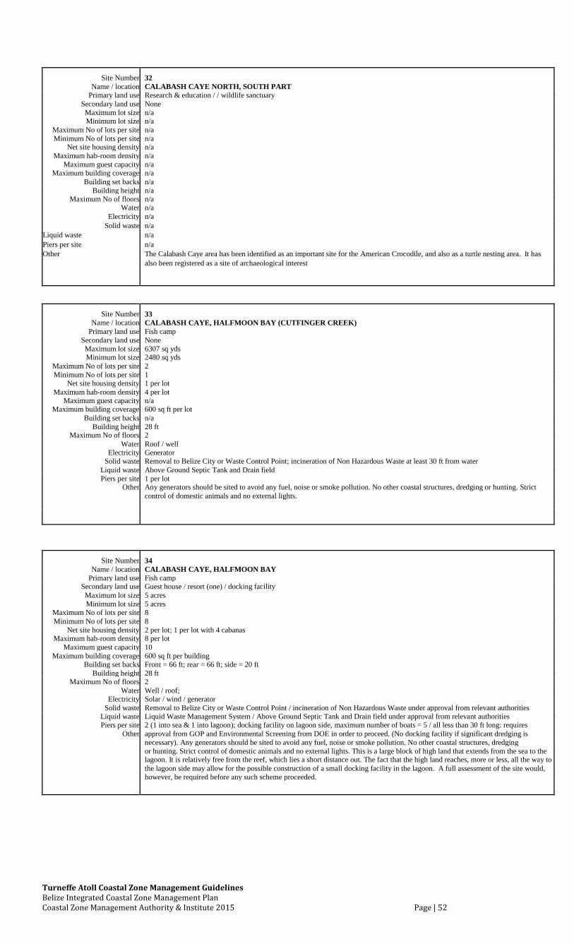
Turneffe Atoll Coastal Zone Management Guidelines Belize Integrated Coastal Zone Management Plan Coastal Zone Management Authority & Institute 2015 Page | 52
Site Number 32 Name / location CALABASH CAYE NORTH, SOUTH PART
Primary land use Research & education / / wildlife sanctuary Secondary land use None Maximum lot size n/a Minimum lot size n/a
Maximum No of lots per site n/a Minimum No of lots per site n/a
Net site housing density n/a Maximum hab-room density n/a
Maximum guest capacity n/a Maximum building coverage n/a
Building set backs n/a Building height n/a
Maximum No of floors n/a Water n/a
Electricity n/a Solid waste n/a
Liquid waste n/a
Piers per site n/a
Other The Calabash Caye area has been identified as an important site for the American Crocodile, and also as a turtle nesting area. It has
also been registered as a site of archaeological interest
Site Number 33 Name / location CALABASH CAYE, HALFMOON BAY (CUTFINGER CREEK)
Primary land use Fish camp Secondary land use None Maximum lot size 6307 sq yds Minimum lot size 2480 sq yds
Maximum No of lots per site 2 Minimum No of lots per site 1
Net site housing density 1 per lot Maximum hab-room density 4 per lot
Maximum guest capacity n/a Maximum building coverage 600 sq ft per lot
Building set backs n/a Building height 28 ft
Maximum No of floors 2 Water Roof / well
Electricity Generator Solid waste Removal to Belize City or Waste Control Point; incineration of Non Hazardous Waste at least 30 ft from water
Liquid waste Above Ground Septic Tank and Drain field Piers per site 1 per lot
Other Any generators should be sited to avoid any fuel, noise or smoke pollution. No other coastal structures, dredging or hunting. Strict control of domestic animals and no external lights.
Site Number 34 Name / location CALABASH CAYE, HALFMOON BAY
Primary land use Fish camp Secondary land use Guest house / resort (one) / docking facility Maximum lot size 5 acres Minimum lot size 5 acres
Maximum No of lots per site 8 Minimum No of lots per site 8
Net site housing density 2 per lot; 1 per lot with 4 cabanas Maximum hab-room density 8 per lot
Maximum guest capacity 10 Maximum building coverage 600 sq ft per building
Building set backs Front = 66 ft; rear = 66 ft; side = 20 ft Building height 28 ft
Maximum No of floors 2 Water Well / roof;
Electricity Solar / wind / generator Solid waste Removal to Belize City or Waste Control Point / incineration of Non Hazardous Waste under approval from relevant authorities
Liquid waste Liquid Waste Management System / Above Ground Septic Tank and Drain field under approval from relevant authorities Piers per site 2 (1 into sea & 1 into lagoon); docking facility on lagoon side, maximum number of boats = 5 / all less than 30 ft long: requires
Other approval from GOP and Environmental Screening from DOE in order to proceed. (No docking facility if significant dredging is necessary). Any generators should be sited to avoid any fuel, noise or smoke pollution. No other coastal structures, dredging or hunting. Strict control of domestic animals and no external lights. This is a large block of high land that extends from the sea to the lagoon. It is relatively free from the reef, which lies a short distance out. The fact that the high land reaches, more or less, all the way to the lagoon side may allow for the possible construction of a small docking facility in the lagoon. A full assessment of the site would, however, be required before any such scheme proceeded.
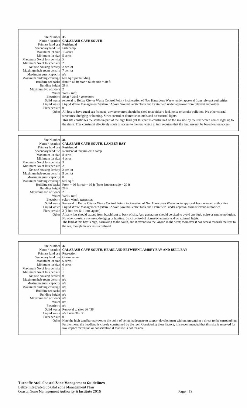
Turneffe Atoll Coastal Zone Management Guidelines Belize Integrated Coastal Zone Management Plan Coastal Zone Management Authority & Institute 2015 Page | 53
Site Number 35 Name / location CALABASH CAYE SOUTH
Primary land use Residential Secondary land use Fish camp Maximum lot size 13 acres Minimum lot size 5 acres
Maximum No of lots per site 5 Minimum No of lots per site 2
Net site housing density 2 per lot Maximum hab-room density 7 per lot
Maximum guest capacity n/a Maximum building coverage 600 sq ft per building
Building set backs front = 66 ft; rear = 66 ft; side = 20 ft Building height 28 ft
Maximum No of floors 2 Water Well / roof;
Electricity Solar / wind / generator; Solid waste removal to Belize City or Waste Control Point / incineration of Non Hazardous Waste under approval from relevant authorities
Liquid waste Liquid Waste Management System / Above Ground Septic Tank and Drain field under approval from relevant authorities Piers per site 0
Other All lots to have equal sea frontage; any generators should be sited to avoid any fuel, noise or smoke pollution. No other coastal structures, dredging or hunting. Strict control of domestic animals and no external lights. This site constitutes the southern part of the high land, yet this part is constrained on the sea side by the reef which comes right up to
the shore. This constraint effectively shuts of access to the sea, which in turn requires that the land use not be based on sea access.
Site Number 36 Name / location CALABASH CAYE SOUTH, LAMBEY BAY
Primary land use Residential Secondary land use Residential tourism /fish camp Maximum lot size 8 acres Minimum lot size 4 acres
Maximum No of lots per site 3 Minimum No of lots per site 2
Net site housing density 2 per lot Maximum hab-room density 5 per lot
Maximum guest capacity 0 Maximum building coverage 600 sq ft
Building set backs Front = 66 ft; rear = 66 ft (from lagoon); side = 20 ft Building height 28 ft
Maximum No of floors 2 Water Well / roof;
Electricity solar / wind / generator; Solid waste Removal to Belize City or Waste Control Point / incineration of Non Hazardous Waste under approval from relevant authorities
Liquid waste Liquid Waste Management System / Above Ground Septic Tank and Drain field under approval from relevant authorities Piers per site 2 (1 into sea & 1 into lagoon)
Other All/any lots should extend from beachfront to back of site. Any generators should be sited to avoid any fuel, noise or smoke pollution. No other coastal structures, dredging or hunting. Strict control of domestic animals and no external lights.
The land at this bay is high, narrowing to the south, and it extends to the lagoon in the west; moreover it has access through the reef to the sea, though the access is confined.
Site Number 37 Name / location CALABASH CAYE SOUTH, HEADLAND BETWEEN LAMBEY BAY AND BULL BAY
Primary land use Recreation Secondary land use Conservation Maximum lot size 6 acres Minimum lot size 6 acres
Maximum No of lots per site 1 Minimum No of lots per site 1
Net site housing density 0 Maximum hab-room density n/a
Maximum guest capacity n/a Maximum building coverage n/a
Building set backs n/a Building height n/a
Maximum No of floors n/a Water n/a
Electricity n/a Solid waste Removal to sites 36 / 38
Liquid waste n/a / sites 36 / 38 Piers per site 0
Other Here the high sand bar narrows to the point of being inadequate to support development without presenting a threat to the surroundings Furthermore, the headland is closely constrained by the reef. Considering these factors, it is recommended that this site is reserved for
low impact recreation or conservation if that use is not feasible.
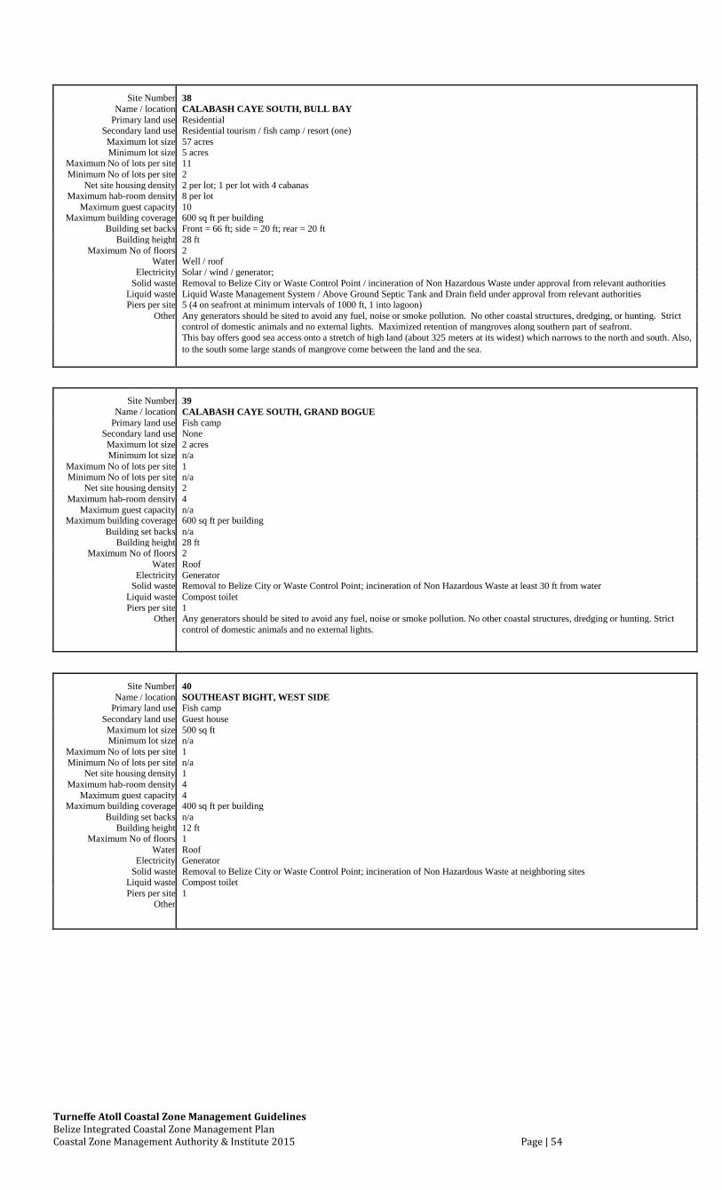
Turneffe Atoll Coastal Zone Management Guidelines Belize Integrated Coastal Zone Management Plan Coastal Zone Management Authority & Institute 2015 Page | 54
Site Number 38
Name / location CALABASH CAYE SOUTH, BULL BAY
Primary land use Residential
Secondary land use Residential tourism / fish camp / resort (one)
Maximum lot size 57 acres
Minimum lot size 5 acres
Maximum No of lots per site 11
Minimum No of lots per site 2
Net site housing density 2 per lot; 1 per lot with 4 cabanas
Maximum hab-room density 8 per lot
Maximum guest capacity 10
Maximum building coverage 600 sq ft per building
Building set backs Front = 66 ft; side = 20 ft; rear = 20 ft
Building height 28 ft
Maximum No of floors 2
Water Well / roof
Electricity Solar / wind / generator;
Solid waste Removal to Belize City or Waste Control Point / incineration of Non Hazardous Waste under approval from relevant authorities
Liquid waste Liquid Waste Management System / Above Ground Septic Tank and Drain field under approval from relevant authorities
Piers per site 5 (4 on seafront at minimum intervals of 1000 ft, 1 into lagoon)
Other Any generators should be sited to avoid any fuel, noise or smoke pollution. No other coastal structures, dredging, or hunting. Strict
control of domestic animals and no external lights. Maximized retention of mangroves along southern part of seafront.
This bay offers good sea access onto a stretch of high land (about 325 meters at its widest) which narrows to the north and south. Also,
to the south some large stands of mangrove come between the land and the sea.
Site Number 39 Name / location CALABASH CAYE SOUTH, GRAND BOGUE
Primary land use Fish camp Secondary land use None Maximum lot size 2 acres Minimum lot size n/a
Maximum No of lots per site 1 Minimum No of lots per site n/a
Net site housing density 2 Maximum hab-room density 4
Maximum guest capacity n/a Maximum building coverage 600 sq ft per building
Building set backs n/a Building height 28 ft
Maximum No of floors 2 Water Roof
Electricity Generator Solid waste Removal to Belize City or Waste Control Point; incineration of Non Hazardous Waste at least 30 ft from water
Liquid waste Compost toilet Piers per site 1
Other Any generators should be sited to avoid any fuel, noise or smoke pollution. No other coastal structures, dredging or hunting. Strict control of domestic animals and no external lights.
Site Number 40 Name / location SOUTHEAST BIGHT, WEST SIDE
Primary land use Fish camp Secondary land use Guest house Maximum lot size 500 sq ft Minimum lot size n/a
Maximum No of lots per site 1 Minimum No of lots per site n/a
Net site housing density 1 Maximum hab-room density 4
Maximum guest capacity 4 Maximum building coverage 400 sq ft per building
Building set backs n/a Building height 12 ft
Maximum No of floors 1 Water Roof
Electricity Generator Solid waste Removal to Belize City or Waste Control Point; incineration of Non Hazardous Waste at neighboring sites
Liquid waste Compost toilet Piers per site 1
Other
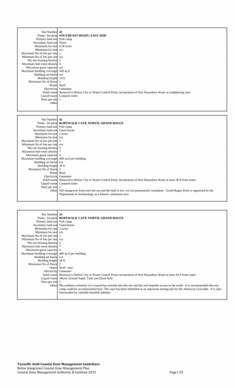
Turneffe Atoll Coastal Zone Management Guidelines Belize Integrated Coastal Zone Management Plan Coastal Zone Management Authority & Institute 2015 Page | 55
Site Number 41 Name / location SOUTHEAST BIGHT, EAST SIDE
Primary land use Fish camp Secondary land use None Maximum lot size 0.50 acres Minimum lot size n/a
Maximum No of lots per site 1 Minimum No of lots per site n/a
Net site housing density 1 Maximum hab-room density 4
Maximum guest capacity n/a Maximum building coverage 500 sq ft
Building set backs n/a Building height 14 ft
Maximum No of floors 1 Water Roof
Electricity Generator Solid waste Removal to Belize City or Waste Control Point; incineration of Non Hazardous Waste at neighboring sites
Liquid waste Compost toilet Piers per site 1
Other
Site Number 42 Name / location ROPEWALK CAYE NORTH, GRAND BOGUE
Primary land use Fish camp Secondary land use Guest house Maximum lot size 2 acres Minimum lot size n/a
Maximum No of lots per site 1 Minimum No of lots per site n/a
Net site housing density 2 Maximum hab-room density 7
Maximum guest capacity 4 Maximum building coverage 600 sq ft per building
Building set backs n/a Building height 28 ft
Maximum No of floors 2 Water Roof
Electricity Generator Solid waste Removal to Belize City or Waste Control Point; incineration of Non Hazardous Waste at least 30 ft from water
Liquid waste Compost toilet Piers per site 1
Other Tall mangroves front onto the sea and the land is low, yet not permanently inundated. Grand Bogue Point is registered by the
Department of Archaeology as a historic settlement area
Site Number 43 Name / location ROPEWALK CAYE NORTH, GRAND BOGUE
Primary land use Fish camp Secondary land use Guest house Maximum lot size 2 acres Minimum lot size n/a
Maximum No of lots per site 1 Minimum No of lots per site n/a
Net site housing density 2 Maximum hab-room density 7
Maximum guest capacity 4 Maximum building coverage 600 sq ft per building
Building set backs n/a Building height 28 ft
Maximum No of floors 2 Water Well / roof
Electricity Generator Solid waste Removal to Belize City or Waste Control Point; incineration of Non Hazardous Waste at least 30 ft from water
Liquid waste Above Ground Septic Tank and Drain field Piers per site 1
Other The northern extremity of a coastal bar extends into this site and the reef impedes access to the south. It is recommended that one
camp could be accommodated here. The caye has been identified as an important nesting site for the American Crocodile. It is also Surrounded by valuable bonefish habitats
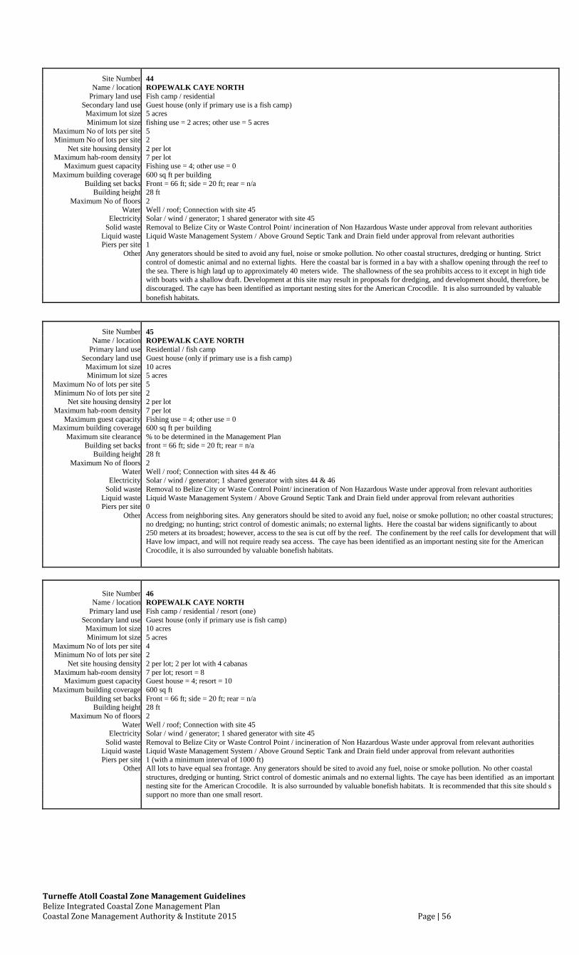
Turneffe Atoll Coastal Zone Management Guidelines Belize Integrated Coastal Zone Management Plan Coastal Zone Management Authority & Institute 2015 Page | 56
Site Number 44 Name / location ROPEWALK CAYE NORTH
Primary land use Fish camp / residential Secondary land use Guest house (only if primary use is a fish camp) Maximum lot size 5 acres Minimum lot size fishing use = 2 acres; other use = 5 acres
Maximum No of lots per site 5 Minimum No of lots per site 2
Net site housing density 2 per lot Maximum hab-room density 7 per lot
Maximum guest capacity Fishing use = 4; other use = 0 Maximum building coverage 600 sq ft per building
Building set backs Front = 66 ft; side = 20 ft; rear = n/a Building height 28 ft
Maximum No of floors 2 Water Well / roof; Connection with site 45
Electricity Solar / wind / generator; 1 shared generator with site 45 Solid waste Removal to Belize City or Waste Control Point/ incineration of Non Hazardous Waste under approval from relevant authorities
Liquid waste Liquid Waste Management System / Above Ground Septic Tank and Drain field under approval from relevant authorities Piers per site 1
Other Any generators should be sited to avoid any fuel, noise or smoke pollution. No other coastal structures, dredging or hunting. Strict control of domestic animal and no external lights. Here the coastal bar is formed in a bay with a shallow opening through the reef to
the sea. There is high land up to approximately 40 meters wide. The shallowness of the sea prohibits access to it except in high tide with boats with a shallow draft. Development at this site may result in proposals for dredging, and development should, therefore, be
discouraged. The caye has been identified as important nesting sites for the American Crocodile. It is also surrounded by valuable
bonefish habitats.
Site Number 45 Name / location ROPEWALK CAYE NORTH
Primary land use Residential / fish camp Secondary land use Guest house (only if primary use is a fish camp) Maximum lot size 10 acres Minimum lot size 5 acres
Maximum No of lots per site 5 Minimum No of lots per site 2
Net site housing density 2 per lot Maximum hab-room density 7 per lot
Maximum guest capacity Fishing use = 4; other use = 0 Maximum building coverage 600 sq ft per building
Maximum site clearance % to be determined in the Management Plan Building set backs front = 66 ft; side = 20 ft; rear = n/a
Building height 28 ft Maximum No of floors 2
Water Well / roof; Connection with sites 44 & 46 Electricity Solar / wind / generator; 1 shared generator with sites 44 & 46
Solid waste Removal to Belize City or Waste Control Point/ incineration of Non Hazardous Waste under approval from relevant authorities Liquid waste Liquid Waste Management System / Above Ground Septic Tank and Drain field under approval from relevant authorities Piers per site 0
Other Access from neighboring sites. Any generators should be sited to avoid any fuel, noise or smoke pollution; no other coastal structures; no dredging; no hunting; strict control of domestic animals; no external lights. Here the coastal bar widens significantly to about
250 meters at its broadest; however, access to the sea is cut off by the reef. The confinement by the reef calls for development that will Have low impact, and will not require ready sea access. The caye has been identified as an important nesting site for the American
Crocodile, it is also surrounded by valuable bonefish habitats.
Site Number 46 Name / location ROPEWALK CAYE NORTH
Primary land use Fish camp / residential / resort (one) Secondary land use Guest house (only if primary use is fish camp) Maximum lot size 10 acres Minimum lot size 5 acres
Maximum No of lots per site 4 Minimum No of lots per site 2
Net site housing density 2 per lot; 2 per lot with 4 cabanas Maximum hab-room density 7 per lot; resort = 8
Maximum guest capacity Guest house = 4; resort = 10 Maximum building coverage 600 sq ft
Building set backs Front = 66 ft; side = 20 ft; rear = n/a Building height 28 ft
Maximum No of floors 2 Water Well / roof; Connection with site 45
Electricity Solar / wind / generator; 1 shared generator with site 45 Solid waste Removal to Belize City or Waste Control Point / incineration of Non Hazardous Waste under approval from relevant authorities
Liquid waste Liquid Waste Management System / Above Ground Septic Tank and Drain field under approval from relevant authorities Piers per site 1 (with a minimum interval of 1000 ft)
Other All lots to have equal sea frontage. Any generators should be sited to avoid any fuel, noise or smoke pollution. No other coastal
structures, dredging or hunting. Strict control of domestic animals and no external lights. The caye has been identified as an important
nesting site for the American Crocodile. It is also surrounded by valuable bonefish habitats. It is recommended that this site should s support no more than one small resort.
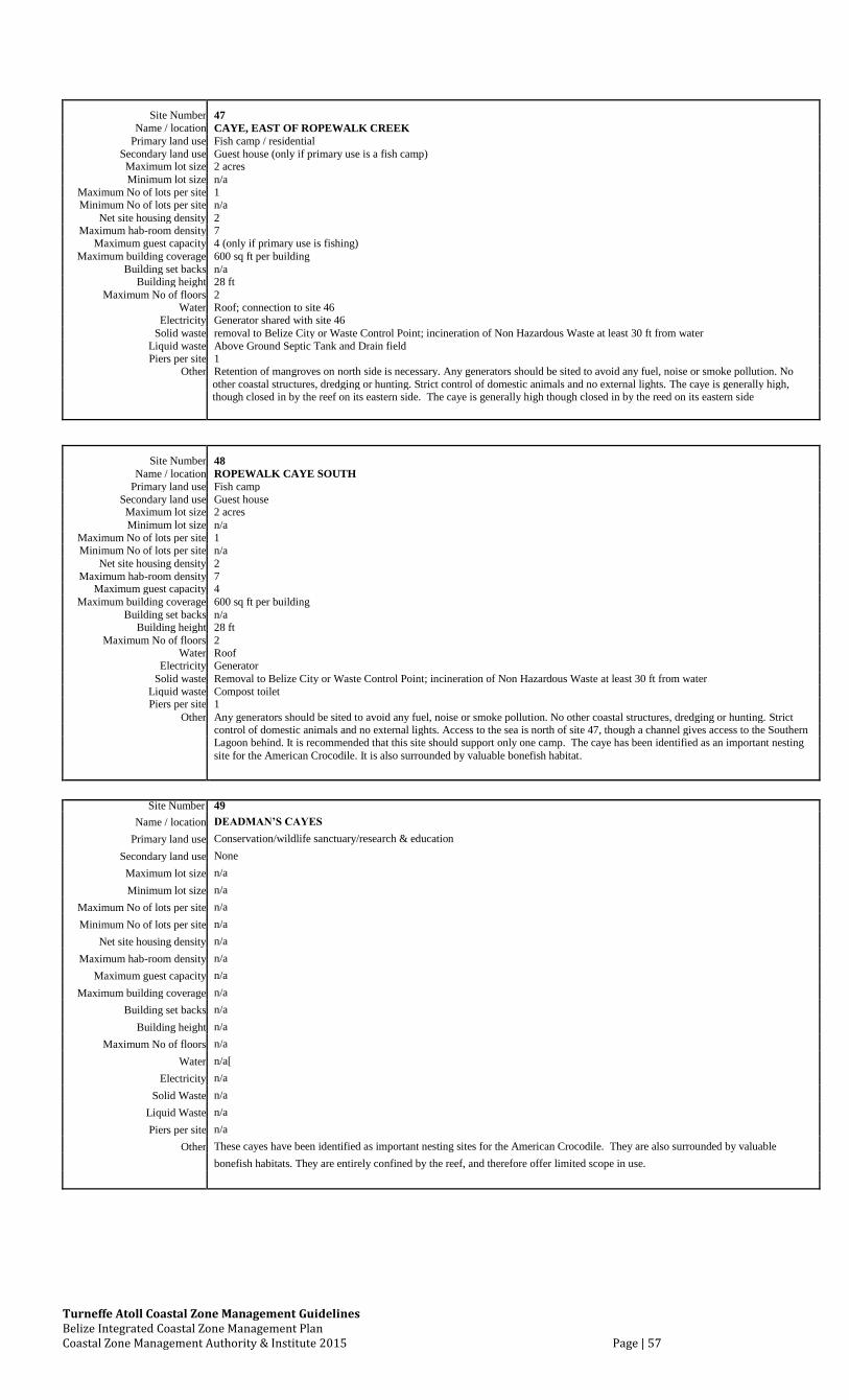
Turneffe Atoll Coastal Zone Management Guidelines Belize Integrated Coastal Zone Management Plan Coastal Zone Management Authority & Institute 2015 Page | 57
Site Number 47 Name / location CAYE, EAST OF ROPEWALK CREEK
Primary land use Fish camp / residential Secondary land use Guest house (only if primary use is a fish camp) Maximum lot size 2 acres Minimum lot size n/a
Maximum No of lots per site 1 Minimum No of lots per site n/a
Net site housing density 2 Maximum hab-room density 7
Maximum guest capacity 4 (only if primary use is fishing) Maximum building coverage 600 sq ft per building
Building set backs n/a Building height 28 ft
Maximum No of floors 2 Water Roof; connection to site 46
Electricity Generator shared with site 46 Solid waste removal to Belize City or Waste Control Point; incineration of Non Hazardous Waste at least 30 ft from water
Liquid waste Above Ground Septic Tank and Drain field Piers per site 1
Other Retention of mangroves on north side is necessary. Any generators should be sited to avoid any fuel, noise or smoke pollution. No other coastal structures, dredging or hunting. Strict control of domestic animals and no external lights. The caye is generally high, though closed in by the reef on its eastern side. The caye is generally high though closed in by the reed on its eastern side
Site Number 48
Name / location ROPEWALK CAYE SOUTH
Primary land use Fish camp
Secondary land use Guest house
Maximum lot size 2 acres
Minimum lot size n/a
Maximum No of lots per site 1
Minimum No of lots per site n/a
Net site housing density 2
Maximum hab-room density 7
Maximum guest capacity 4
Maximum building coverage 600 sq ft per building
Building set backs n/a
Building height 28 ft
Maximum No of floors 2
Water Roof
Electricity Generator
Solid waste Removal to Belize City or Waste Control Point; incineration of Non Hazardous Waste at least 30 ft from water
Liquid waste Compost toilet
Piers per site 1
Other Any generators should be sited to avoid any fuel, noise or smoke pollution. No other coastal structures, dredging or hunting. Strict
control of domestic animals and no external lights. Access to the sea is north of site 47, though a channel gives access to the Southern
Lagoon behind. It is recommended that this site should support only one camp. The caye has been identified as an important nesting
site for the American Crocodile. It is also surrounded by valuable bonefish habitat.
Site Number 49
Name / location DEADMAN’S CAYES
Primary land use Conservation/wildlife sanctuary/research & education
Secondary land use None
Maximum lot size n/a
Minimum lot size n/a
Maximum No of lots per site n/a
Minimum No of lots per site n/a
Net site housing density n/a
Maximum hab-room density n/a
Maximum guest capacity n/a
Maximum building coverage n/a
Building set backs n/a
Building height n/a
Maximum No of floors n/a
Water n/a[
Electricity n/a
Solid Waste n/a
Liquid Waste n/a
Piers per site n/a
Other These cayes have been identified as important nesting sites for the American Crocodile. They are also surrounded by valuable
bonefish habitats. They are entirely confined by the reef, and therefore offer limited scope in use.
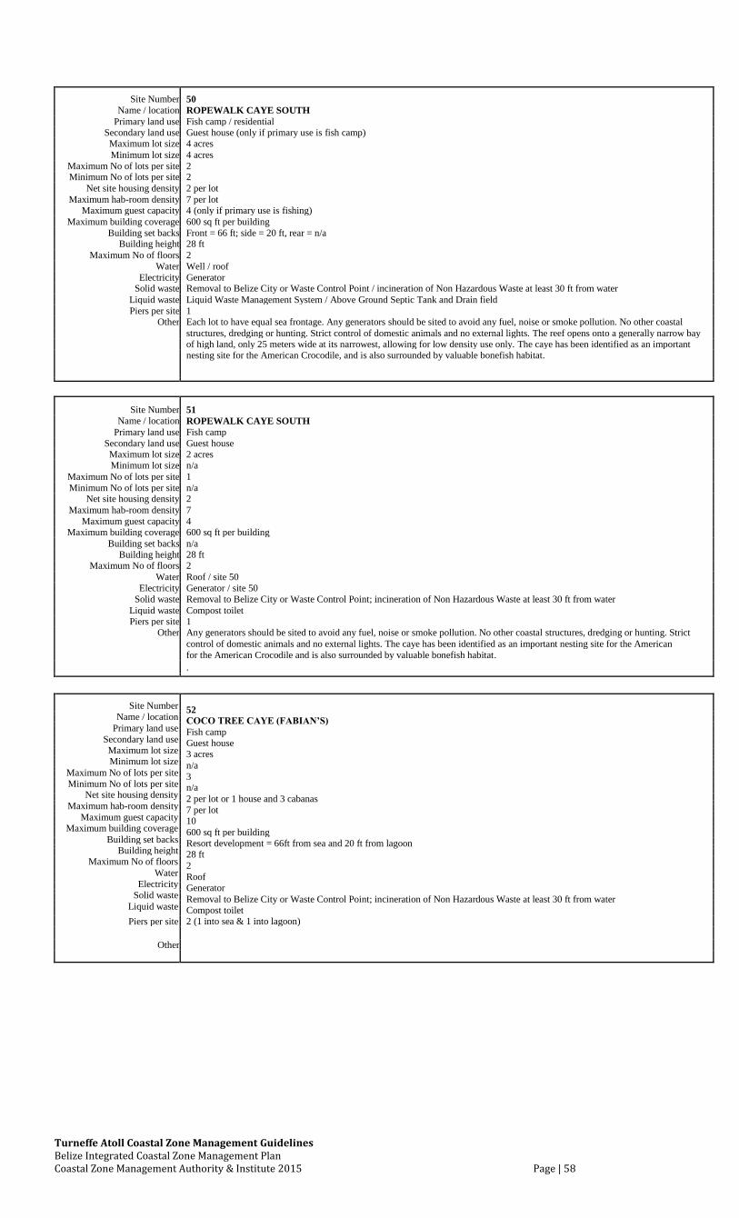
Turneffe Atoll Coastal Zone Management Guidelines Belize Integrated Coastal Zone Management Plan Coastal Zone Management Authority & Institute 2015 Page | 58
Site Number 50
Name / location ROPEWALK CAYE SOUTH
Primary land use Fish camp / residential
Secondary land use Guest house (only if primary use is fish camp)
Maximum lot size 4 acres
Minimum lot size 4 acres
Maximum No of lots per site 2
Minimum No of lots per site 2
Net site housing density 2 per lot
Maximum hab-room density 7 per lot
Maximum guest capacity 4 (only if primary use is fishing)
Maximum building coverage 600 sq ft per building
Building set backs Front = 66 ft; side = 20 ft, rear = n/a
Building height 28 ft
Maximum No of floors 2
Water Well / roof
Electricity Generator
Solid waste Removal to Belize City or Waste Control Point / incineration of Non Hazardous Waste at least 30 ft from water
Liquid waste Liquid Waste Management System / Above Ground Septic Tank and Drain field
Piers per site 1
Other Each lot to have equal sea frontage. Any generators should be sited to avoid any fuel, noise or smoke pollution. No other coastal
structures, dredging or hunting. Strict control of domestic animals and no external lights. The reef opens onto a generally narrow bay
of high land, only 25 meters wide at its narrowest, allowing for low density use only. The caye has been identified as an important
nesting site for the American Crocodile, and is also surrounded by valuable bonefish habitat.
Site Number 51
Name / location ROPEWALK CAYE SOUTH
Primary land use Fish camp
Secondary land use Guest house
Maximum lot size 2 acres
Minimum lot size n/a
Maximum No of lots per site 1
Minimum No of lots per site n/a
Net site housing density 2
Maximum hab-room density 7
Maximum guest capacity 4
Maximum building coverage 600 sq ft per building
Building set backs n/a
Building height 28 ft
Maximum No of floors 2
Water Roof / site 50
Electricity Generator / site 50
Solid waste Removal to Belize City or Waste Control Point; incineration of Non Hazardous Waste at least 30 ft from water
Liquid waste Compost toilet
Piers per site 1
Other Any generators should be sited to avoid any fuel, noise or smoke pollution. No other coastal structures, dredging or hunting. Strict
control of domestic animals and no external lights. The caye has been identified as an important nesting site for the American
for the American Crocodile and is also surrounded by valuable bonefish habitat.
.
Site Number 52
Name / location
COCO TREE CAYE (FABIAN’S)
Primary land use
Fish camp
Secondary land use
Guest house
Maximum lot size
3 acres
Minimum lot size
n/a
Maximum No of lots per site
3
Minimum No of lots per site
n/a
Net site housing density
2 per lot or 1 house and 3 cabanas
Maximum hab-room density
7 per lot
Maximum guest capacity
10
Maximum building coverage
600 sq ft per building
Building set backs
Resort development = 66ft from sea and 20 ft from lagoon
Building height
28 ft
Maximum No of floors
2
Water
Roof
Electricity
Generator
Solid waste
Removal to Belize City or Waste Control Point; incineration of Non Hazardous Waste at least 30 ft from water
Liquid waste
Compost toilet
Piers per site
2 (1 into sea & 1 into lagoon)
Other
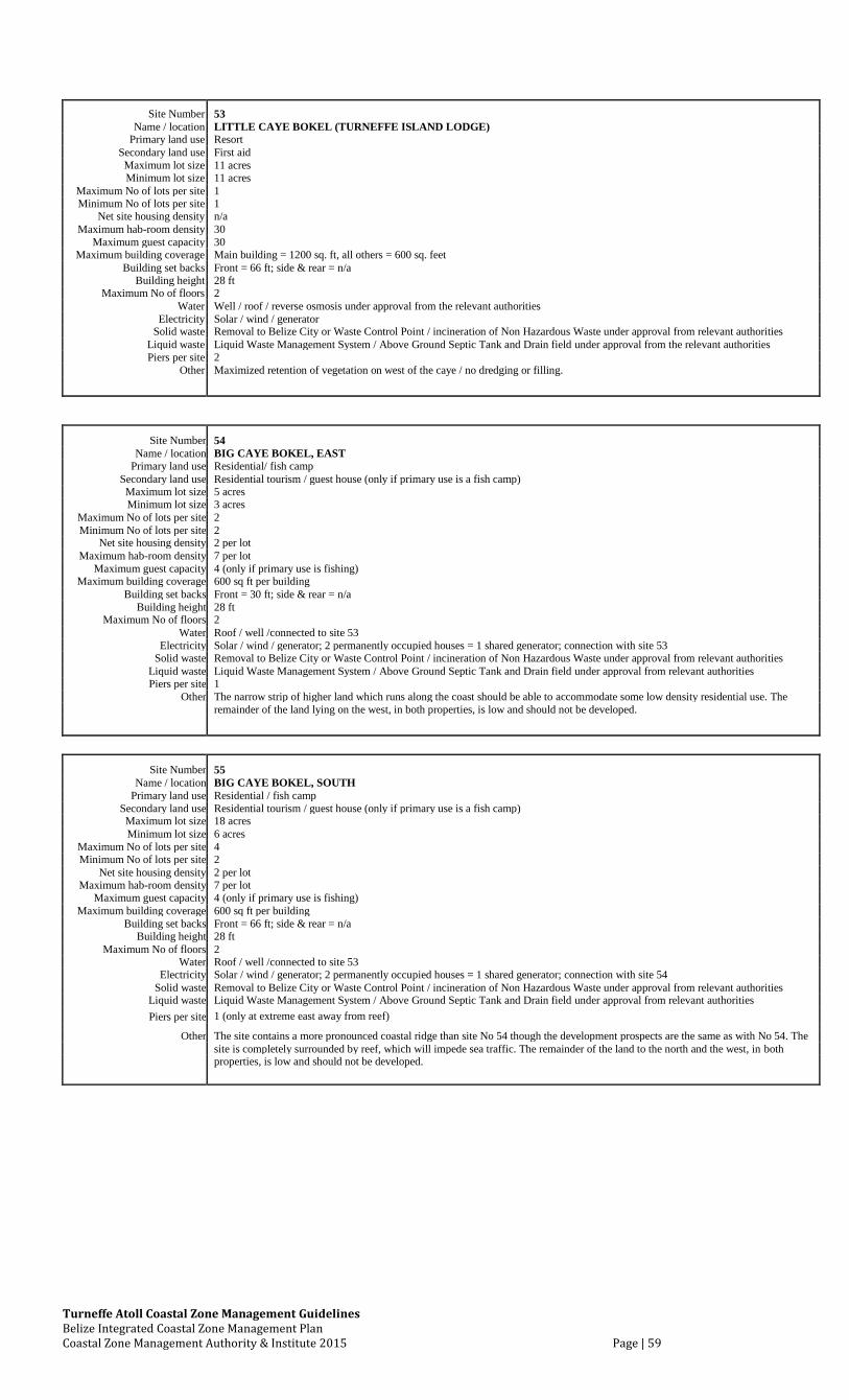
Turneffe Atoll Coastal Zone Management Guidelines Belize Integrated Coastal Zone Management Plan Coastal Zone Management Authority & Institute 2015 Page | 59
Site Number 53
Name / location LITTLE CAYE BOKEL (TURNEFFE ISLAND LODGE)
Primary land use Resort
Secondary land use First aid
Maximum lot size 11 acres
Minimum lot size 11 acres
Maximum No of lots per site 1
Minimum No of lots per site 1
Net site housing density n/a
Maximum hab-room density 30
Maximum guest capacity 30
Maximum building coverage Main building = 1200 sq. ft, all others = 600 sq. feet
Building set backs Front = 66 ft; side & rear = n/a
Building height 28 ft
Maximum No of floors 2
Water Well / roof / reverse osmosis under approval from the relevant authorities
Electricity Solar / wind / generator
Solid waste Removal to Belize City or Waste Control Point / incineration of Non Hazardous Waste under approval from relevant authorities
Liquid waste Liquid Waste Management System / Above Ground Septic Tank and Drain field under approval from the relevant authorities
Piers per site 2
Other Maximized retention of vegetation on west of the caye / no dredging or filling.
Site Number 54 Name / location BIG CAYE BOKEL, EAST
Primary land use Residential/ fish camp Secondary land use Residential tourism / guest house (only if primary use is a fish camp) Maximum lot size 5 acres Minimum lot size 3 acres
Maximum No of lots per site 2 Minimum No of lots per site 2
Net site housing density 2 per lot Maximum hab-room density 7 per lot
Maximum guest capacity 4 (only if primary use is fishing) Maximum building coverage 600 sq ft per building
Building set backs Front = 30 ft; side & rear = n/a Building height 28 ft
Maximum No of floors 2 Water Roof / well /connected to site 53
Electricity Solar / wind / generator; 2 permanently occupied houses = 1 shared generator; connection with site 53 Solid waste Removal to Belize City or Waste Control Point / incineration of Non Hazardous Waste under approval from relevant authorities
Liquid waste Liquid Waste Management System / Above Ground Septic Tank and Drain field under approval from relevant authorities Piers per site 1
Other The narrow strip of higher land which runs along the coast should be able to accommodate some low density residential use. The remainder of the land lying on the west, in both properties, is low and should not be developed.
Site Number 55
Name / location BIG CAYE BOKEL, SOUTH
Primary land use Residential / fish camp
Secondary land use Residential tourism / guest house (only if primary use is a fish camp)
Maximum lot size 18 acres
Minimum lot size 6 acres
Maximum No of lots per site 4
Minimum No of lots per site 2
Net site housing density 2 per lot
Maximum hab-room density 7 per lot
Maximum guest capacity 4 (only if primary use is fishing)
Maximum building coverage 600 sq ft per building
Building set backs Front = 66 ft; side & rear = n/a
Building height 28 ft
Maximum No of floors 2
Water Roof / well /connected to site 53
Electricity Solar / wind / generator; 2 permanently occupied houses = 1 shared generator; connection with site 54
Solid waste Removal to Belize City or Waste Control Point / incineration of Non Hazardous Waste under approval from relevant authorities
Liquid waste Liquid Waste Management System / Above Ground Septic Tank and Drain field under approval from relevant authorities
Piers per site 1 (only at extreme east away from reef)
Other
The site contains a more pronounced coastal ridge than site No 54 though the development prospects are the same as with No 54. The
site is completely surrounded by reef, which will impede sea traffic. The remainder of the land to the north and the west, in both
properties, is low and should not be developed.
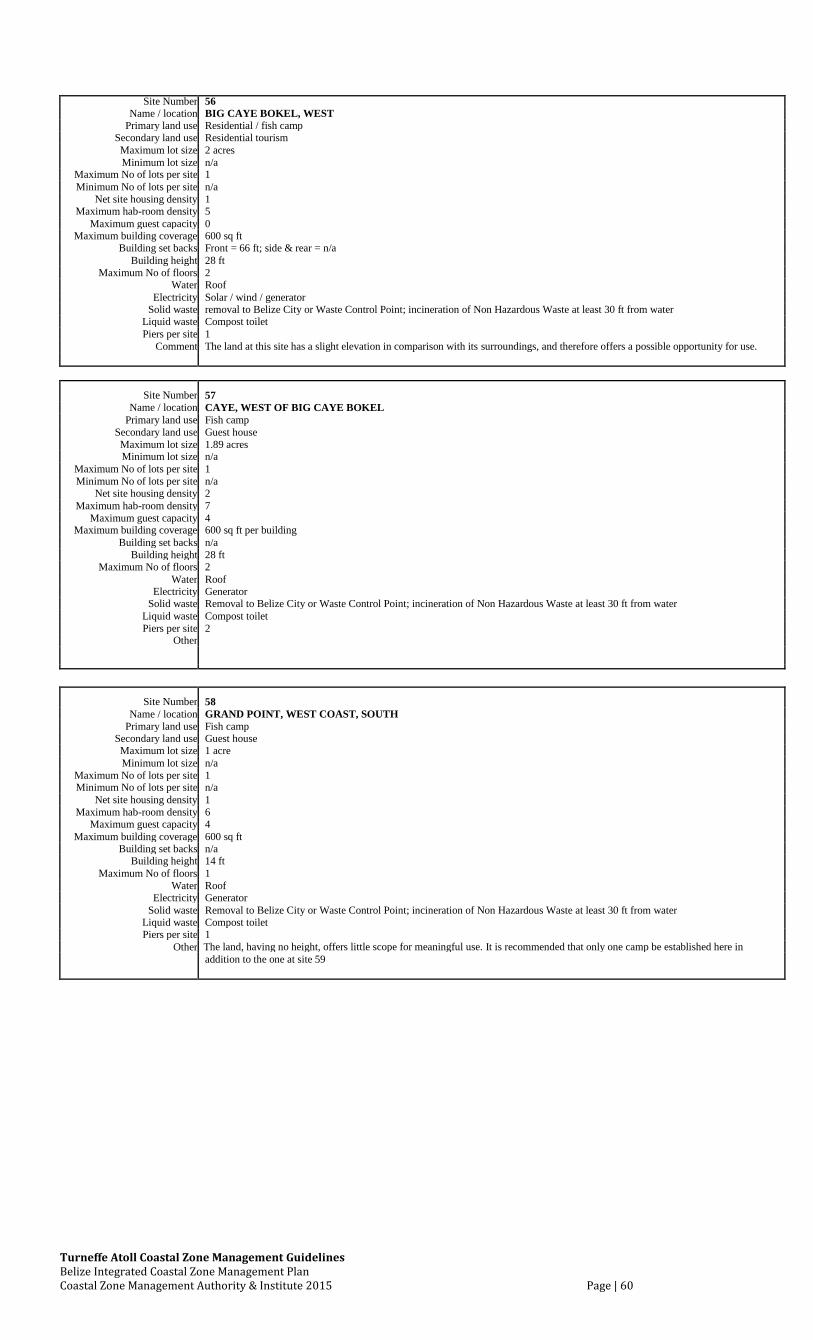
Turneffe Atoll Coastal Zone Management Guidelines Belize Integrated Coastal Zone Management Plan Coastal Zone Management Authority & Institute 2015 Page | 60
Site Number 56
Name / location BIG CAYE BOKEL, WEST
Primary land use Residential / fish camp
Secondary land use Residential tourism
Maximum lot size 2 acres
Minimum lot size n/a
Maximum No of lots per site 1
Minimum No of lots per site n/a
Net site housing density 1
Maximum hab-room density 5
Maximum guest capacity 0
Maximum building coverage 600 sq ft
Building set backs Front = 66 ft; side & rear = n/a
Building height 28 ft
Maximum No of floors 2
Water Roof
Electricity Solar / wind / generator
Solid waste removal to Belize City or Waste Control Point; incineration of Non Hazardous Waste at least 30 ft from water
Liquid waste Compost toilet
Piers per site 1
Comment The land at this site has a slight elevation in comparison with its surroundings, and therefore offers a possible opportunity for use.
Site Number 57 Name / location CAYE, WEST OF BIG CAYE BOKEL
Primary land use Fish camp Secondary land use Guest house Maximum lot size 1.89 acres Minimum lot size n/a
Maximum No of lots per site 1 Minimum No of lots per site n/a
Net site housing density 2 Maximum hab-room density 7
Maximum guest capacity 4 Maximum building coverage 600 sq ft per building
Building set backs n/a Building height 28 ft
Maximum No of floors 2 Water Roof
Electricity Generator Solid waste Removal to Belize City or Waste Control Point; incineration of Non Hazardous Waste at least 30 ft from water
Liquid waste Compost toilet Piers per site 2
Other
Site Number 58 Name / location GRAND POINT, WEST COAST, SOUTH
Primary land use Fish camp Secondary land use Guest house Maximum lot size 1 acre Minimum lot size n/a
Maximum No of lots per site 1 Minimum No of lots per site n/a
Net site housing density 1 Maximum hab-room density 6
Maximum guest capacity 4 Maximum building coverage 600 sq ft
Building set backs n/a Building height 14 ft
Maximum No of floors 1 Water Roof
Electricity Generator Solid waste Removal to Belize City or Waste Control Point; incineration of Non Hazardous Waste at least 30 ft from water
Liquid waste Compost toilet Piers per site 1
Other The land, having no height, offers little scope for meaningful use. It is recommended that only one camp be established here in
addition to the one at site 59
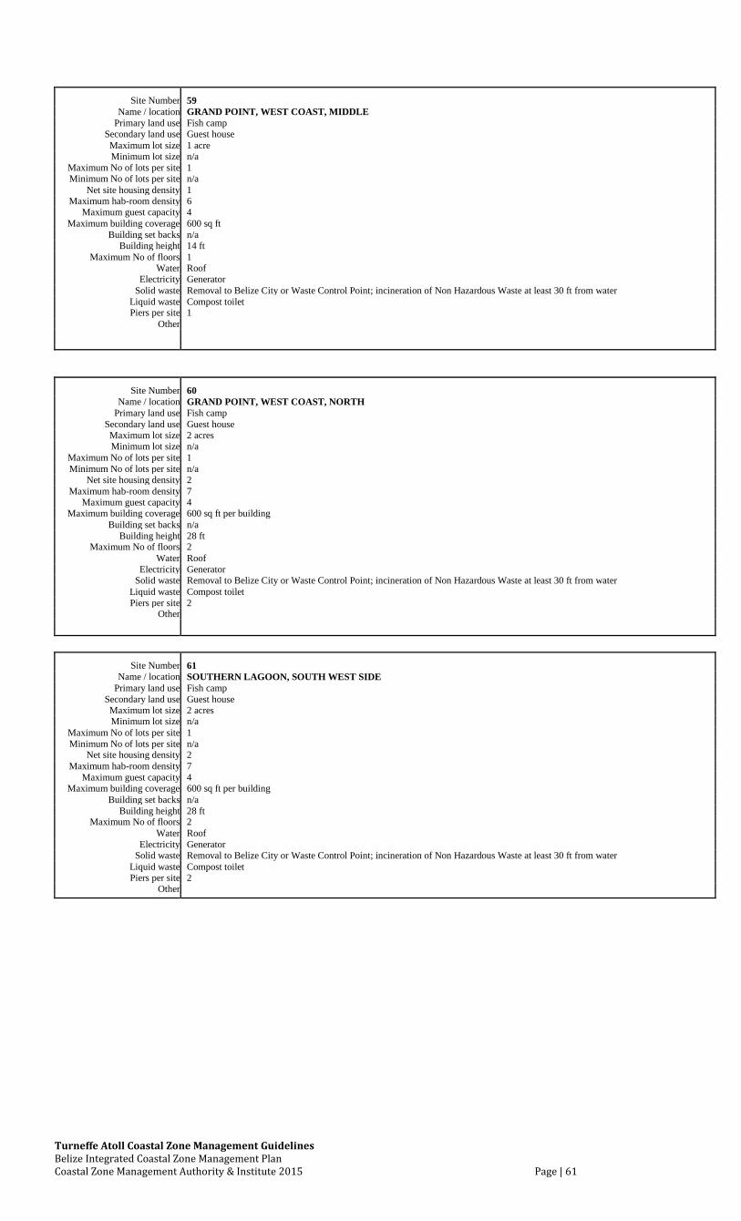
Turneffe Atoll Coastal Zone Management Guidelines Belize Integrated Coastal Zone Management Plan Coastal Zone Management Authority & Institute 2015 Page | 61
Site Number 59 Name / location GRAND POINT, WEST COAST, MIDDLE
Primary land use Fish camp Secondary land use Guest house Maximum lot size 1 acre Minimum lot size n/a
Maximum No of lots per site 1 Minimum No of lots per site n/a
Net site housing density 1 Maximum hab-room density 6
Maximum guest capacity 4 Maximum building coverage 600 sq ft
Building set backs n/a Building height 14 ft
Maximum No of floors 1 Water Roof
Electricity Generator Solid waste Removal to Belize City or Waste Control Point; incineration of Non Hazardous Waste at least 30 ft from water
Liquid waste Compost toilet Piers per site 1
Other
Site Number 60 Name / location GRAND POINT, WEST COAST, NORTH
Primary land use Fish camp Secondary land use Guest house Maximum lot size 2 acres Minimum lot size n/a
Maximum No of lots per site 1 Minimum No of lots per site n/a
Net site housing density 2 Maximum hab-room density 7
Maximum guest capacity 4 Maximum building coverage 600 sq ft per building
Building set backs n/a Building height 28 ft
Maximum No of floors 2 Water Roof
Electricity Generator Solid waste Removal to Belize City or Waste Control Point; incineration of Non Hazardous Waste at least 30 ft from water
Liquid waste Compost toilet Piers per site 2
Other
Site Number 61 Name / location SOUTHERN LAGOON, SOUTH WEST SIDE
Primary land use Fish camp Secondary land use Guest house Maximum lot size 2 acres Minimum lot size n/a
Maximum No of lots per site 1 Minimum No of lots per site n/a
Net site housing density 2 Maximum hab-room density 7
Maximum guest capacity 4 Maximum building coverage 600 sq ft per building
Building set backs n/a Building height 28 ft
Maximum No of floors 2 Water Roof
Electricity Generator Solid waste Removal to Belize City or Waste Control Point; incineration of Non Hazardous Waste at least 30 ft from water
Liquid waste Compost toilet Piers per site 2
Other
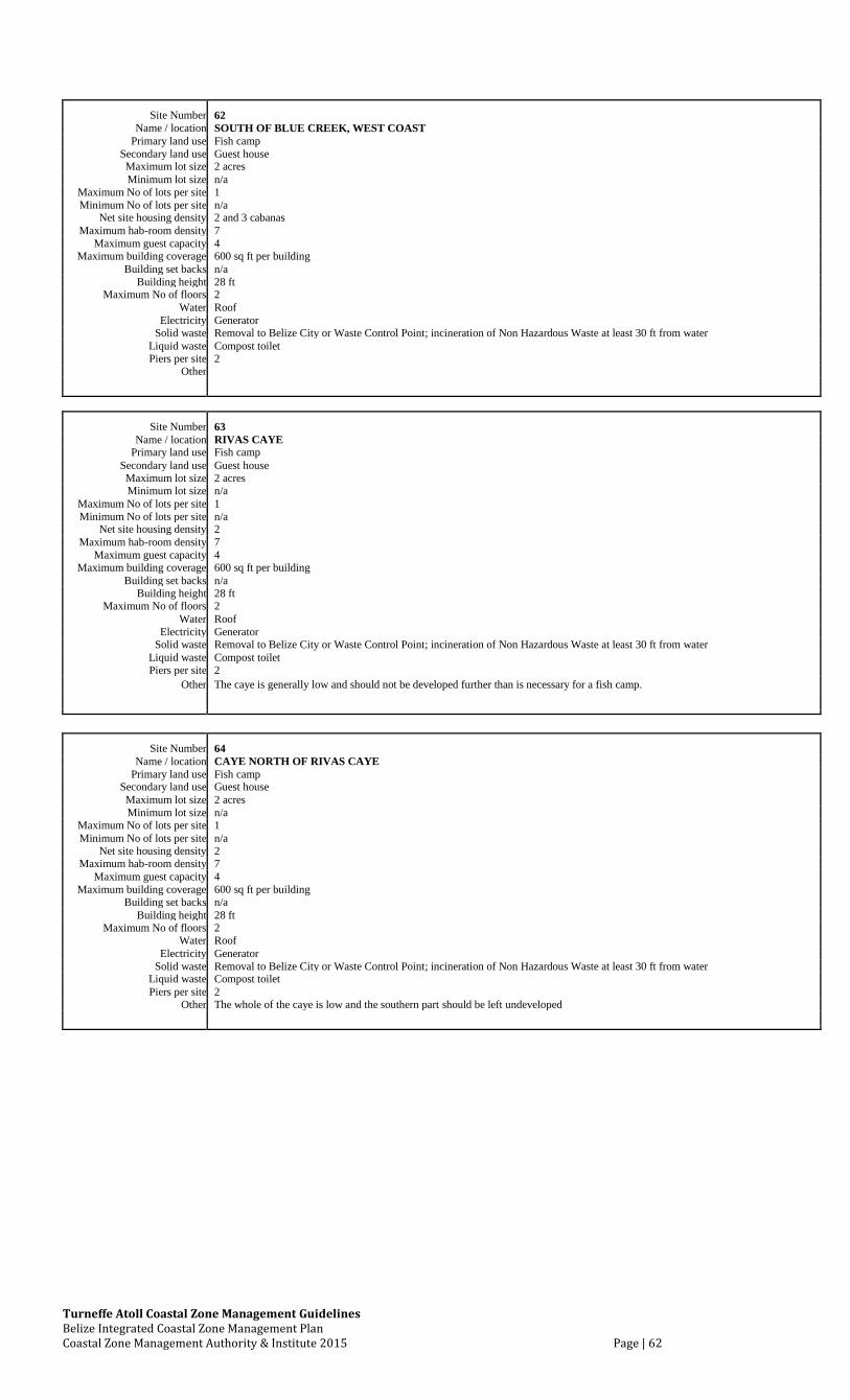
Turneffe Atoll Coastal Zone Management Guidelines Belize Integrated Coastal Zone Management Plan Coastal Zone Management Authority & Institute 2015 Page | 62
Site Number 62 Name / location SOUTH OF BLUE CREEK, WEST COAST
Primary land use Fish camp Secondary land use Guest house Maximum lot size 2 acres Minimum lot size n/a
Maximum No of lots per site 1 Minimum No of lots per site n/a
Net site housing density 2 and 3 cabanas Maximum hab-room density 7
Maximum guest capacity 4 Maximum building coverage 600 sq ft per building
Building set backs n/a Building height 28 ft
Maximum No of floors 2 Water Roof
Electricity Generator Solid waste Removal to Belize City or Waste Control Point; incineration of Non Hazardous Waste at least 30 ft from water
Liquid waste Compost toilet Piers per site 2
Other
Site Number 63 Name / location RIVAS CAYE
Primary land use Fish camp Secondary land use Guest house Maximum lot size 2 acres Minimum lot size n/a
Maximum No of lots per site 1 Minimum No of lots per site n/a
Net site housing density 2 Maximum hab-room density 7
Maximum guest capacity 4 Maximum building coverage 600 sq ft per building
Building set backs n/a Building height 28 ft
Maximum No of floors 2 Water Roof
Electricity Generator Solid waste Removal to Belize City or Waste Control Point; incineration of Non Hazardous Waste at least 30 ft from water
Liquid waste Compost toilet Piers per site 2
Other The caye is generally low and should not be developed further than is necessary for a fish camp.
Site Number 64 Name / location CAYE NORTH OF RIVAS CAYE
Primary land use Fish camp Secondary land use Guest house Maximum lot size 2 acres Minimum lot size n/a
Maximum No of lots per site 1 Minimum No of lots per site n/a
Net site housing density 2 Maximum hab-room density 7
Maximum guest capacity 4 Maximum building coverage 600 sq ft per building
Building set backs n/a Building height 28 ft
Maximum No of floors 2 Water Roof
Electricity Generator Solid waste Removal to Belize City or Waste Control Point; incineration of Non Hazardous Waste at least 30 ft from water
Liquid waste Compost toilet Piers per site 2
Other The whole of the caye is low and the southern part should be left undeveloped
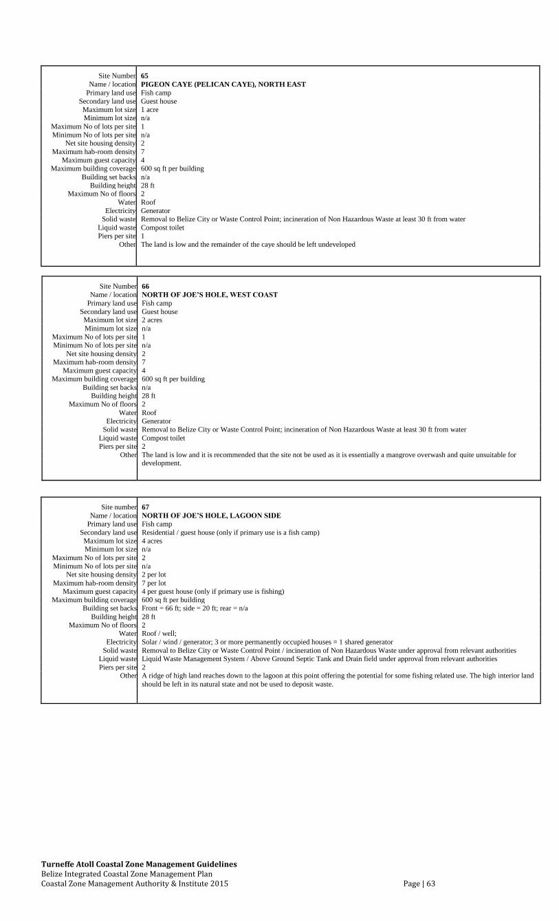
Turneffe Atoll Coastal Zone Management Guidelines Belize Integrated Coastal Zone Management Plan Coastal Zone Management Authority & Institute 2015 Page | 63
Site Number 65 Name / location PIGEON CAYE (PELICAN CAYE), NORTH EAST
Primary land use Fish camp Secondary land use Guest house Maximum lot size 1 acre Minimum lot size n/a
Maximum No of lots per site 1 Minimum No of lots per site n/a
Net site housing density 2 Maximum hab-room density 7
Maximum guest capacity 4 Maximum building coverage 600 sq ft per building
Building set backs n/a Building height 28 ft
Maximum No of floors 2 Water Roof
Electricity Generator Solid waste Removal to Belize City or Waste Control Point; incineration of Non Hazardous Waste at least 30 ft from water
Liquid waste Compost toilet Piers per site 1
Other The land is low and the remainder of the caye should be left undeveloped
Site Number 66 Name / location NORTH OF JOE’S HOLE, WEST COAST
Primary land use Fish camp Secondary land use Guest house Maximum lot size 2 acres Minimum lot size n/a
Maximum No of lots per site 1 Minimum No of lots per site n/a
Net site housing density 2 Maximum hab-room density 7
Maximum guest capacity 4 Maximum building coverage 600 sq ft per building
Building set backs n/a Building height 28 ft
Maximum No of floors 2 Water Roof
Electricity Generator Solid waste Removal to Belize City or Waste Control Point; incineration of Non Hazardous Waste at least 30 ft from water
Liquid waste Compost toilet Piers per site 2
Other The land is low and it is recommended that the site not be used as it is essentially a mangrove overwash and quite unsuitable for
development.
Site number 67 Name / location NORTH OF JOE’S HOLE, LAGOON SIDE
Primary land use Fish camp Secondary land use Residential / guest house (only if primary use is a fish camp) Maximum lot size 4 acres Minimum lot size n/a
Maximum No of lots per site 2 Minimum No of lots per site n/a
Net site housing density 2 per lot Maximum hab-room density 7 per lot
Maximum guest capacity 4 per guest house (only if primary use is fishing) Maximum building coverage 600 sq ft per building
Building set backs Front = 66 ft; side = 20 ft; rear = n/a Building height 28 ft
Maximum No of floors 2 Water Roof / well;
Electricity Solar / wind / generator; 3 or more permanently occupied houses = 1 shared generator Solid waste Removal to Belize City or Waste Control Point / incineration of Non Hazardous Waste under approval from relevant authorities
Liquid waste Liquid Waste Management System / Above Ground Septic Tank and Drain field under approval from relevant authorities Piers per site 2
Other A ridge of high land reaches down to the lagoon at this point offering the potential for some fishing related use. The high interior land should be left in its natural state and not be used to deposit waste.
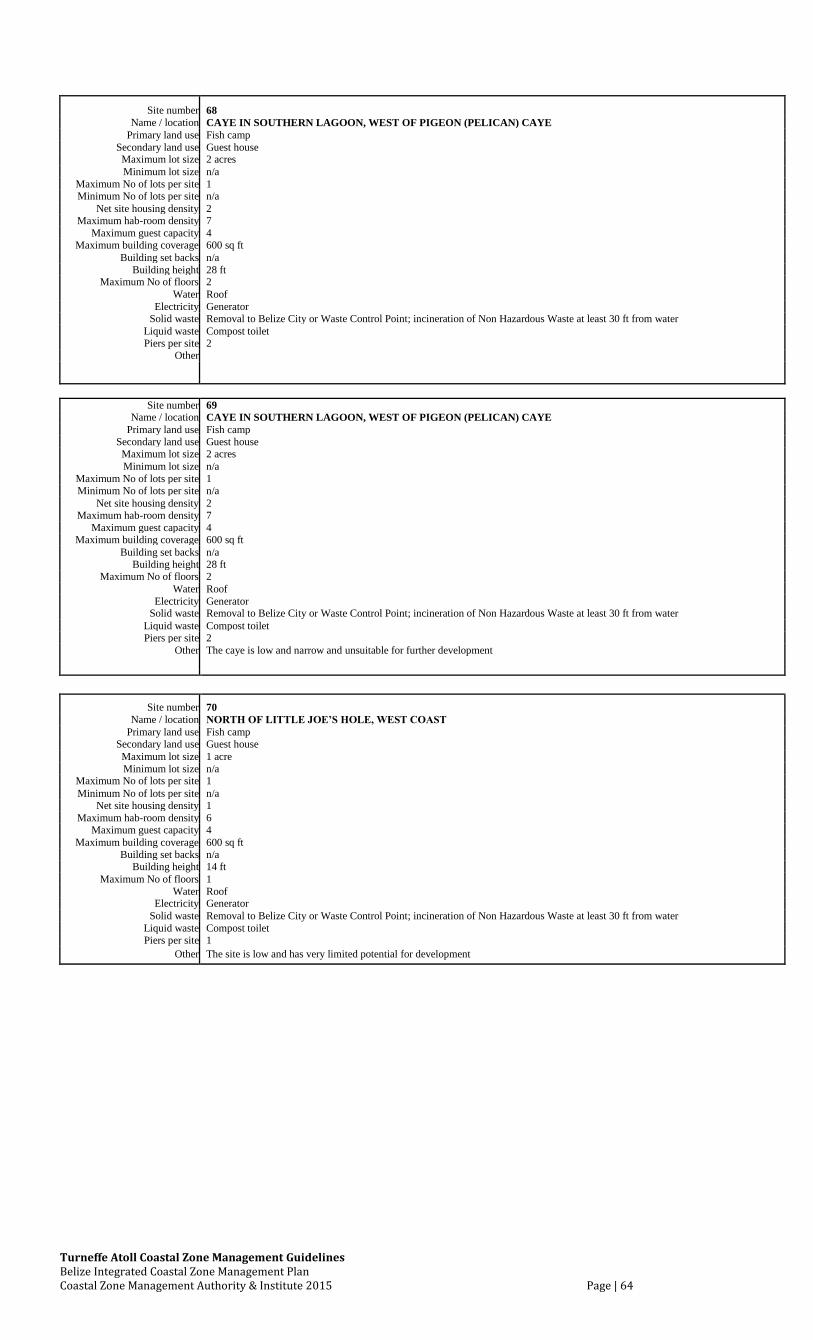
Turneffe Atoll Coastal Zone Management Guidelines Belize Integrated Coastal Zone Management Plan Coastal Zone Management Authority & Institute 2015 Page | 64
Site number 68 Name / location CAYE IN SOUTHERN LAGOON, WEST OF PIGEON (PELICAN) CAYE
Primary land use Fish camp Secondary land use Guest house Maximum lot size 2 acres Minimum lot size n/a
Maximum No of lots per site 1 Minimum No of lots per site n/a
Net site housing density 2 Maximum hab-room density 7
Maximum guest capacity 4 Maximum building coverage 600 sq ft
Building set backs n/a Building height 28 ft
Maximum No of floors 2 Water Roof
Electricity Generator Solid waste Removal to Belize City or Waste Control Point; incineration of Non Hazardous Waste at least 30 ft from water
Liquid waste Compost toilet Piers per site 2
Other
Site number 69
Name / location CAYE IN SOUTHERN LAGOON, WEST OF PIGEON (PELICAN) CAYE Primary land use Fish camp
Secondary land use Guest house Maximum lot size 2 acres Minimum lot size n/a
Maximum No of lots per site 1 Minimum No of lots per site n/a
Net site housing density 2 Maximum hab-room density 7
Maximum guest capacity 4 Maximum building coverage 600 sq ft
Building set backs n/a Building height 28 ft
Maximum No of floors 2 Water Roof
Electricity Generator Solid waste Removal to Belize City or Waste Control Point; incineration of Non Hazardous Waste at least 30 ft from water
Liquid waste Compost toilet Piers per site 2
Other The caye is low and narrow and unsuitable for further development
Site number 70 Name / location NORTH OF LITTLE JOE’S HOLE, WEST COAST
Primary land use Fish camp Secondary land use Guest house Maximum lot size 1 acre Minimum lot size n/a
Maximum No of lots per site 1 Minimum No of lots per site n/a
Net site housing density 1 Maximum hab-room density 6
Maximum guest capacity 4 Maximum building coverage 600 sq ft
Building set backs n/a Building height 14 ft
Maximum No of floors 1 Water Roof
Electricity Generator Solid waste Removal to Belize City or Waste Control Point; incineration of Non Hazardous Waste at least 30 ft from water
Liquid waste Compost toilet Piers per site 1
Other The site is low and has very limited potential for development
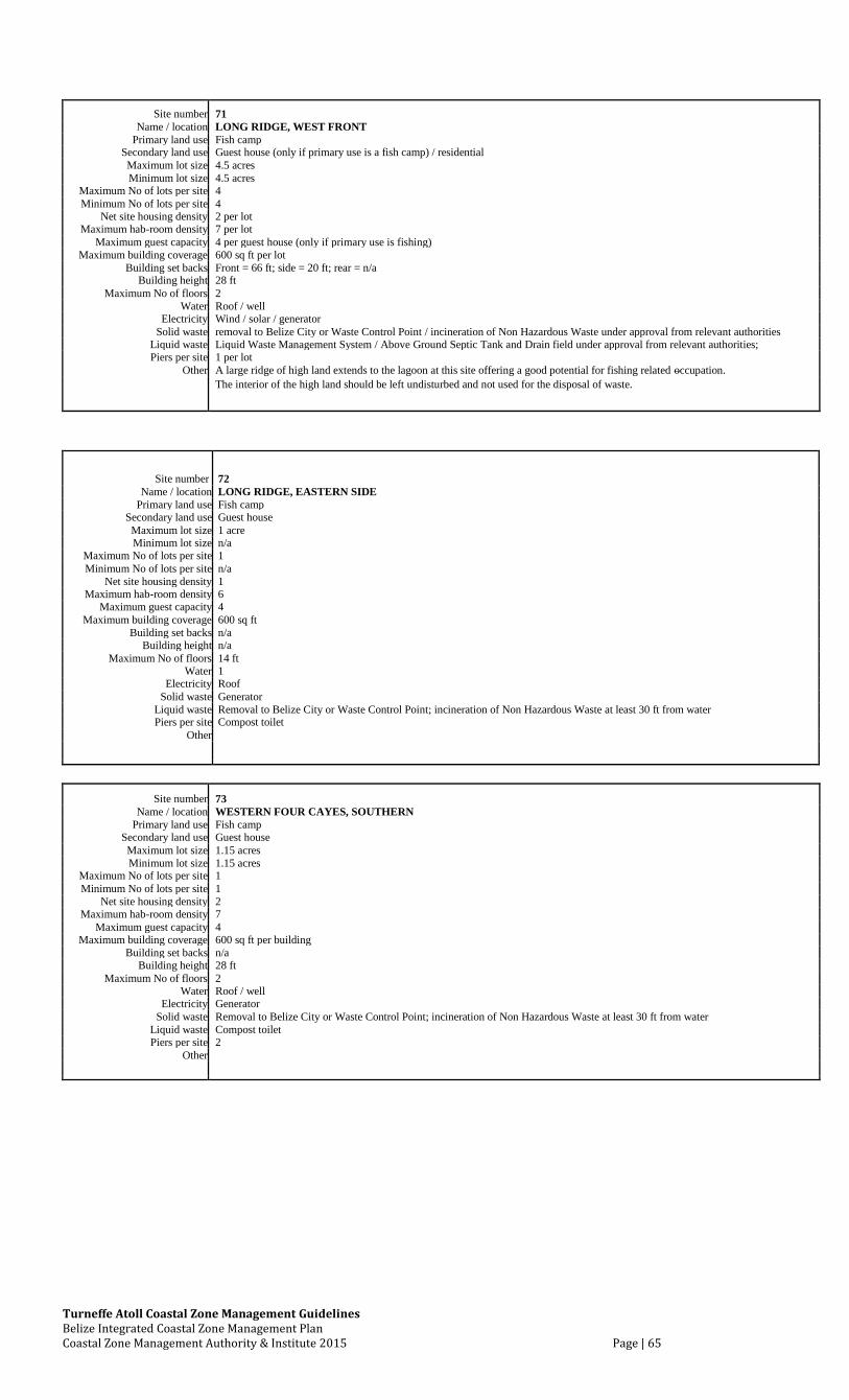
Turneffe Atoll Coastal Zone Management Guidelines Belize Integrated Coastal Zone Management Plan Coastal Zone Management Authority & Institute 2015 Page | 65
Site number 71 Name / location LONG RIDGE, WEST FRONT
Primary land use Fish camp Secondary land use Guest house (only if primary use is a fish camp) / residential Maximum lot size 4.5 acres Minimum lot size 4.5 acres
Maximum No of lots per site 4 Minimum No of lots per site 4
Net site housing density 2 per lot Maximum hab-room density 7 per lot
Maximum guest capacity 4 per guest house (only if primary use is fishing) Maximum building coverage 600 sq ft per lot
Building set backs Front = 66 ft; side = 20 ft; rear = n/a Building height 28 ft
Maximum No of floors 2 Water Roof / well
Electricity Wind / solar / generator Solid waste removal to Belize City or Waste Control Point / incineration of Non Hazardous Waste under approval from relevant authorities
Liquid waste Liquid Waste Management System / Above Ground Septic Tank and Drain field under approval from relevant authorities; Piers per site 1 per lot
Other A large ridge of high land extends to the lagoon at this site offering a good potential for fishing related occupation. The interior of the high land should be left undisturbed and not used for the disposal of waste.
Site number 72 Name / location LONG RIDGE, EASTERN SIDE
Primary land use Fish camp Secondary land use Guest house Maximum lot size 1 acre Minimum lot size n/a
Maximum No of lots per site 1 Minimum No of lots per site n/a
Net site housing density 1 Maximum hab-room density 6
Maximum guest capacity 4 Maximum building coverage 600 sq ft
Building set backs n/a Building height n/a
Maximum No of floors 14 ft Water 1
Electricity Roof Solid waste Generator
Liquid waste Removal to Belize City or Waste Control Point; incineration of Non Hazardous Waste at least 30 ft from water Piers per site Compost toilet
Other
Site number 73 Name / location WESTERN FOUR CAYES, SOUTHERN
Primary land use Fish camp Secondary land use Guest house Maximum lot size 1.15 acres Minimum lot size 1.15 acres
Maximum No of lots per site 1 Minimum No of lots per site 1
Net site housing density 2 Maximum hab-room density 7
Maximum guest capacity 4 Maximum building coverage 600 sq ft per building
Building set backs n/a Building height 28 ft
Maximum No of floors 2 Water Roof / well
Electricity Generator Solid waste Removal to Belize City or Waste Control Point; incineration of Non Hazardous Waste at least 30 ft from water
Liquid waste Compost toilet Piers per site 2
Other

Turneffe Atoll Coastal Zone Management Guidelines Belize Integrated Coastal Zone Management Plan Coastal Zone Management Authority & Institute 2015 Page | 66
Site number 74 Name / location WESTERN FOUR CAYES, SOUTHERN PART OF SOUTH MIDDLE CAYE
Primary land use Fish camp Secondary land use Guest house Maximum lot size 2 acres Minimum lot size n/a
Maximum No of lots per site 1 Minimum No of lots per site n/a
Net site housing density 2 Maximum hab-room density 7
Maximum guest capacity 4 Maximum building coverage 600 sq ft per building
Building set backs n/a Building height 28 ft
Maximum No of floors 2 Water Roof
Electricity Generator Solid waste Removal to Belize City or Waste Control Point; incineration of Non Hazardous Waste at least 30 ft from water
Liquid waste Compost toilet Piers per site 2
Other The caye is very low and unsuitable for further development.
Site number 75 Name / location GRAND BOGUE CREEK, SOUTH SIDE OF WESTERN MOUTH
Primary land use Fish camp Secondary land use Guest house Maximum lot size 1 acre Minimum lot size n/a
Maximum No of lots per site 1 Minimum No of lots per site n/a
Net site housing density 1 Maximum hab-room density 6
Maximum guest capacity 4 Maximum building coverage 600 sq ft
Building set backs n/a Building height 14 ft
Maximum No of floors 1 Water Roof
Electricity Generator Solid waste Removal to Belize City or Waste Control Point; incineration of Non Hazardous Waste at least 30 ft from water
Liquid waste Compost toilet Piers per site 1
Other
Site number 76 Name / location SOUTH OF TARPON CREEK, WEST COAST
Primary land use Fish camp Secondary land use Guest house Maximum lot size 1 acre Minimum lot size n/a
Maximum No of lots per site 1 Minimum No of lots per site n/a
Net site housing density 1 Maximum hab-room density 6
Maximum guest capacity 4 Maximum building coverage 600 sq ft
Building set backs n/a Building height 14 ft
Maximum No of floors 1 Water Roof
Electricity Generator Solid waste Removal to Belize City or Waste Control Point; incineration of Non Hazardous Waste at least 30 ft from water
Liquid waste Compost toilet Piers per site 1
Other
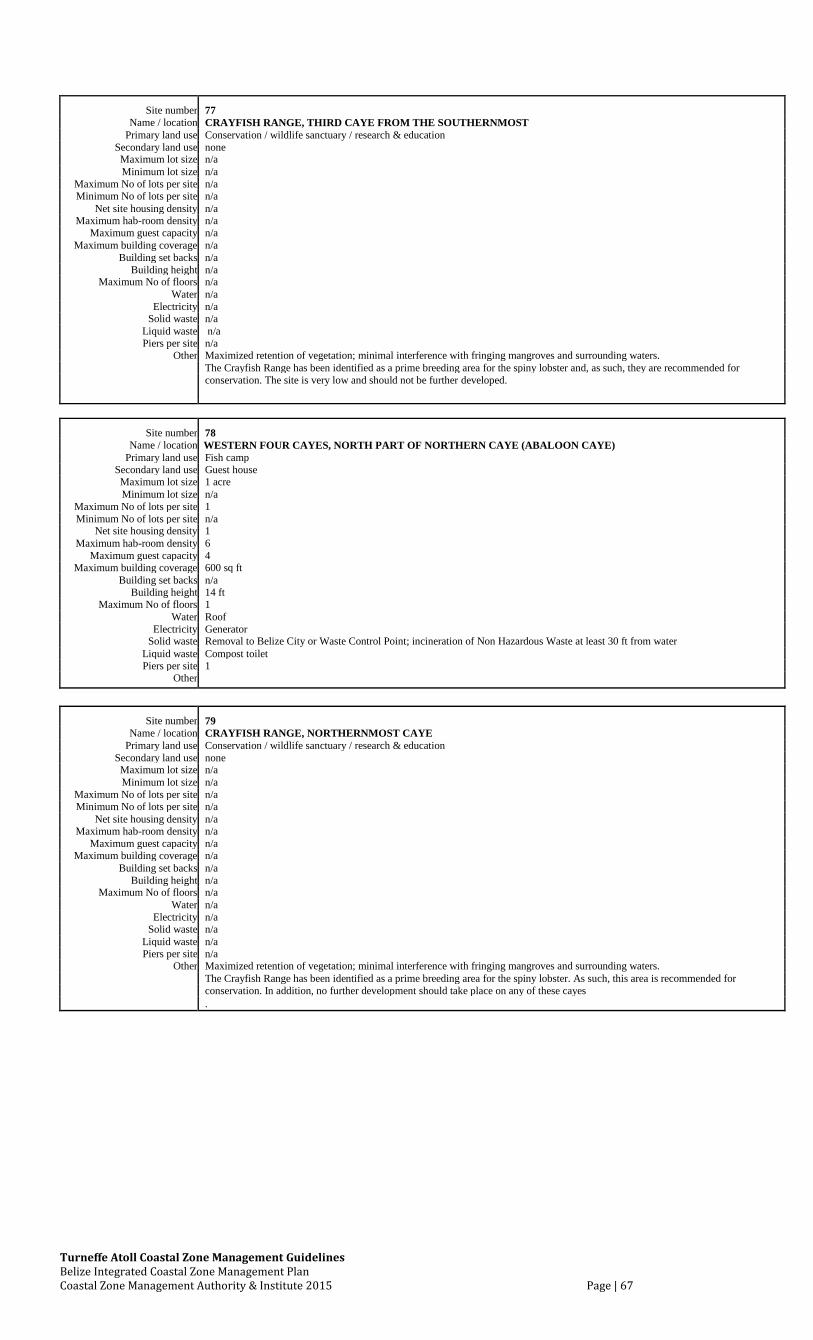
Turneffe Atoll Coastal Zone Management Guidelines Belize Integrated Coastal Zone Management Plan Coastal Zone Management Authority & Institute 2015 Page | 67
Site number 77 Name / location CRAYFISH RANGE, THIRD CAYE FROM THE SOUTHERNMOST
Primary land use Conservation / wildlife sanctuary / research & education Secondary land use none Maximum lot size n/a Minimum lot size n/a
Maximum No of lots per site n/a Minimum No of lots per site n/a
Net site housing density n/a Maximum hab-room density n/a
Maximum guest capacity n/a Maximum building coverage n/a
Building set backs n/a Building height n/a
Maximum No of floors n/a Water n/a
Electricity n/a Solid waste n/a
Liquid waste n/a Piers per site n/a
Other Maximized retention of vegetation; minimal interference with fringing mangroves and surrounding waters. The Crayfish Range has been identified as a prime breeding area for the spiny lobster and, as such, they are recommended for
conservation. The site is very low and should not be further developed.
Site number 78 Name / location WESTERN FOUR CAYES, NORTH PART OF NORTHERN CAYE (ABALOON CAYE)
Primary land use Fish camp Secondary land use Guest house Maximum lot size 1 acre Minimum lot size n/a
Maximum No of lots per site 1 Minimum No of lots per site n/a
Net site housing density 1 Maximum hab-room density 6
Maximum guest capacity 4 Maximum building coverage 600 sq ft
Building set backs n/a Building height 14 ft
Maximum No of floors 1 Water Roof
Electricity Generator Solid waste Removal to Belize City or Waste Control Point; incineration of Non Hazardous Waste at least 30 ft from water
Liquid waste Compost toilet Piers per site 1
Other
Site number 79 Name / location CRAYFISH RANGE, NORTHERNMOST CAYE
Primary land use Conservation / wildlife sanctuary / research & education Secondary land use none Maximum lot size n/a Minimum lot size n/a
Maximum No of lots per site n/a Minimum No of lots per site n/a
Net site housing density n/a Maximum hab-room density n/a
Maximum guest capacity n/a Maximum building coverage n/a
Building set backs n/a Building height n/a
Maximum No of floors n/a Water n/a
Electricity n/a Solid waste n/a
Liquid waste n/a Piers per site n/a
Other Maximized retention of vegetation; minimal interference with fringing mangroves and surrounding waters. The Crayfish Range has been identified as a prime breeding area for the spiny lobster. As such, this area is recommended for
conservation. In addition, no further development should take place on any of these cayes .
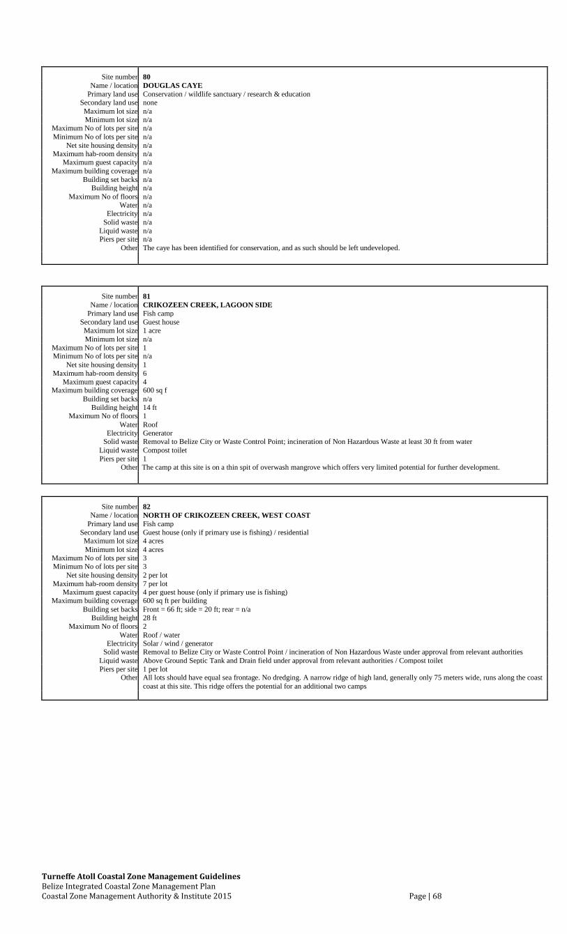
Turneffe Atoll Coastal Zone Management Guidelines Belize Integrated Coastal Zone Management Plan Coastal Zone Management Authority & Institute 2015 Page | 68
Site number 80 Name / location DOUGLAS CAYE
Primary land use Conservation / wildlife sanctuary / research & education Secondary land use none Maximum lot size n/a Minimum lot size n/a
Maximum No of lots per site n/a Minimum No of lots per site n/a
Net site housing density n/a Maximum hab-room density n/a
Maximum guest capacity n/a Maximum building coverage n/a
Building set backs n/a Building height n/a
Maximum No of floors n/a Water n/a
Electricity n/a Solid waste n/a
Liquid waste n/a Piers per site n/a
Other The caye has been identified for conservation, and as such should be left undeveloped.
Site number 81 Name / location CRIKOZEEN CREEK, LAGOON SIDE
Primary land use Fish camp Secondary land use Guest house Maximum lot size 1 acre Minimum lot size n/a
Maximum No of lots per site 1 Minimum No of lots per site n/a
Net site housing density 1 Maximum hab-room density 6
Maximum guest capacity 4 Maximum building coverage 600 sq f
Building set backs n/a Building height 14 ft
Maximum No of floors 1 Water Roof
Electricity Generator Solid waste Removal to Belize City or Waste Control Point; incineration of Non Hazardous Waste at least 30 ft from water
Liquid waste Compost toilet Piers per site 1
Other The camp at this site is on a thin spit of overwash mangrove which offers very limited potential for further development.
Site number 82 Name / location NORTH OF CRIKOZEEN CREEK, WEST COAST
Primary land use Fish camp Secondary land use Guest house (only if primary use is fishing) / residential Maximum lot size 4 acres Minimum lot size 4 acres
Maximum No of lots per site 3 Minimum No of lots per site 3
Net site housing density 2 per lot Maximum hab-room density 7 per lot
Maximum guest capacity 4 per guest house (only if primary use is fishing) Maximum building coverage 600 sq ft per building
Building set backs Front = 66 ft; side = 20 ft; rear = n/a Building height 28 ft
Maximum No of floors 2 Water Roof / water
Electricity Solar / wind / generator Solid waste Removal to Belize City or Waste Control Point / incineration of Non Hazardous Waste under approval from relevant authorities
Liquid waste Above Ground Septic Tank and Drain field under approval from relevant authorities / Compost toilet Piers per site 1 per lot
Other All lots should have equal sea frontage. No dredging. A narrow ridge of high land, generally only 75 meters wide, runs along the coast coast at this site. This ridge offers the potential for an additional two camps
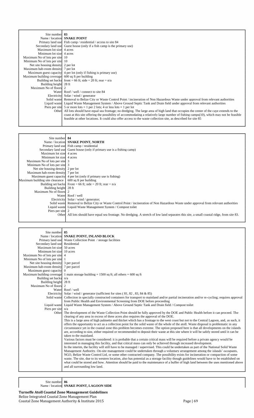
Turneffe Atoll Coastal Zone Management Guidelines Belize Integrated Coastal Zone Management Plan Coastal Zone Management Authority & Institute 2015 Page | 69
Site number 83 Name / location SNAKE POINT
Primary land use Fish camp / residential / access to site 84 Secondary land use Guest house (only if a fish camp is the primary use) Maximum lot size 4 acres Minimum lot size 4 acres
Maximum No of lots per site 10 Minimum No of lots per site 10
Net site housing density 2 per lot Maximum hab-room density 7 per lot
Maximum guest capacity 4 per lot (only if fishing is primary use) Maximum building coverage 600 sq ft per building
Building set backs front = 66 ft; side = 20 ft; rear = n/a Building height 28 ft
Maximum No of floors 2 Water Roof / well / connect to site 84
Electricity Solar / wind / generator Solid waste Removal to Belize City or Waste Control Point / incineration of Non Hazardous Waste under approval from relevant authorities
Liquid waste Liquid Waste Management System / Above Ground Septic Tank and Drain field under approval from relevant authorities Piers per site 5 or more lots = 1 per 2 lots; 4 or less lots = 1 per lot
Other All lots should have equal sea frontage; no dredging. The large area of high land that occupies the center of the caye extends to the
coast at this site offering the possibility of accommodating a relatively large number of fishing camps(10), which may not be feasible feasible at other locations. It could also offer access to the waste collection site, as described for site 85
Site number 84 Name / location SNAKE POINT, NORTH
Primary land use Fish camp / residential Secondary land use Guest house (only if primary use is a fishing camp) Maximum lot size 4 acres
Minimum lot size 4 acres
Maximum No of lots per site 3 Minimum No of lots per site 3
Net site housing density 2 per lot
Maximum hab-room density 7 per lot
Maximum guest capacity 4 per lot (only if primary use is fishing) Maximum building site clearance 600 sq ft per building
Building set backs Front = 66 ft; side = 20 ft; rear = n/a Building height 28 ft
Maximum No of floors 2
Water Roof / well
Electricity Solar / wind / generator; Solid waste Removal to Belize City or Waste Control Point / incineration of Non Hazardous Waste under approval from relevant authorities
Liquid waste Liquid Waste Management System / Compost toilet
Piers per site 2 Other All lots should have equal sea frontage. No dredging. A stretch of low land separates this site, a small coastal ridge, from site 83.
Site number 85
Name / location SNAKE POINT, INLAND BLOCK
Primary land use Waste Collection Point / storage facilities
Secondary land use Residential
Maximum lot size 50 acres
Minimum lot size 10 acres
Maximum No of lots per site 4
Minimum No of lots per site 1
Net site housing density 3 per parcel
Maximum hab-room density 7 per parcel
Maximum guest capacity 0
Maximum building coverage 1 main storage building = 1500 sq ft; all others = 600 sq ft
Building set backs n/a
Building height 28 ft
Maximum No of floors 2
Water Roof / well
Electricity Solar / wind / generator (sufficient for sites ( 81, 82 , 83, 84 & 85)
Solid waste Collection in specially constructed containers for transport to mainland and/or partial incineration and/or re-cycling; requires approval
Liquid waste from Public Health and Environmental Screening from DOE before proceeding
Liquid Waste Management System / Above Ground Septic Tank and Drain field / Compost toilet
Piers per site n/a
Other The development of the Waste Collection Point should be fully approved by the DOE and Public Health before it can proceed. The
clearing of any area in excess of three acres also requires the approval of the DOE.
This is a large area of high palmetto and thicket which has a frontage to the west coast but not to the Central Lagoon, and, as such, it
offers the opportunity to act as a collection point for the solid waste of the whole of the atoll. Waste disposal is problematic in any
circumstance yet in the coastal zone this problem becomes extreme. The option proposed here is that all developments on the islands
are, according to size, either required or recommended to deposit their waste at this site where it will be safely stored until it can be
taken to the mainland.
Various factors must be considered: it is probable that a certain critical mass will be required before a private agency would be
interested in managing this facility, and that critical mass can only be achieved through increased development.
In the interim, the facility will still have to be managed / supervised. This could be undertaken as part of the National Solid Waste
Management Authority. On-site management could be undertaken through a voluntary arrangement among the islands’ occupants,
NGO, Belize Waste Control Ltd, or some other contracted company. The possibility exists for incineration or compaction of some
waste. The site, due to its western location, also has potential as a storage facility though guidelines would have to be established on
what could be stored and how. Attention should be paid to the maintenance of a buffer of high land between the uses mentioned above
and all surrounding low land.
Site number 86 Name / location SNAKE POINT, LAGOON SIDE
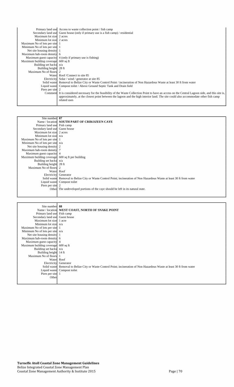
Turneffe Atoll Coastal Zone Management Guidelines Belize Integrated Coastal Zone Management Plan Coastal Zone Management Authority & Institute 2015 Page | 70
Primary land use Access to waste collection point / fish camp Secondary land use Guest house (only if primary use is a fish camp) / residential Maximum lot size 2 acres Minimum lot size 2 acres
Maximum No of lots per site 1 Minimum No of lots per site 1
Net site housing density 1 Maximum hab-room density 6
Maximum guest capacity 4 (only if primary use is fishing) Maximum building coverage 600 sq ft
Building set backs n/a Building height 28 ft
Maximum No of floors 2 Water Roof /Connect to site 85
Electricity Solar / wind / generator at site 85 Solid waste Removal to Belize City or Waste Control Point / incineration of Non Hazardous Waste at least 30 ft from water
Liquid waste Compost toilet / Above Ground Septic Tank and Drain field Piers per site 2
Comment It is considered necessary for the feasibility of the Waste Collection Point to have an access on the Central Lagoon side, and this site is,
approximately, at the closest point between the lagoon and the high interior land. The site could also accommodate other fish camp related uses
Site number 87
Name / location SOUTH PART OF CRIKOZEEN CAYE Primary land use Fish camp
Secondary land use Guest house Maximum lot size 2 acres Minimum lot size n/a
Maximum No of lots per site 1 Minimum No of lots per site n/a
Net site housing density 2 Maximum hab-room density 7
Maximum guest capacity 4 Maximum building coverage 600 sq ft per building
Building set backs n/a Building height 28 ft
Maximum No of floors 2 Water Roof
Electricity Generator Solid waste Removal to Belize City or Waste Control Point; incineration of Non Hazardous Waste at least 30 ft from water
Liquid waste Compost toilet Piers per site 2
Other The undeveloped portions of the caye should be left in its natural state.
Site number 88 Name / location WEST COAST, NORTH OF SNAKE POINT
Primary land use Fish camp Secondary land use Guest house Maximum lot size 1 acre Minimum lot size n/a
Maximum No of lots per site 1 Minimum No of lots per site n/a
Net site housing density 1 Maximum hab-room density 6
Maximum guest capacity 4 Maximum building coverage 600 sq ft
Building set backs n/a Building height 14 ft
Maximum No of floors 1 Water Roof
Electricity Generator Solid waste Removal to Belize City or Waste Control Point; incineration of Non Hazardous Waste at least 30 ft from water
Liquid waste Compost toilet Piers per site 1
Other
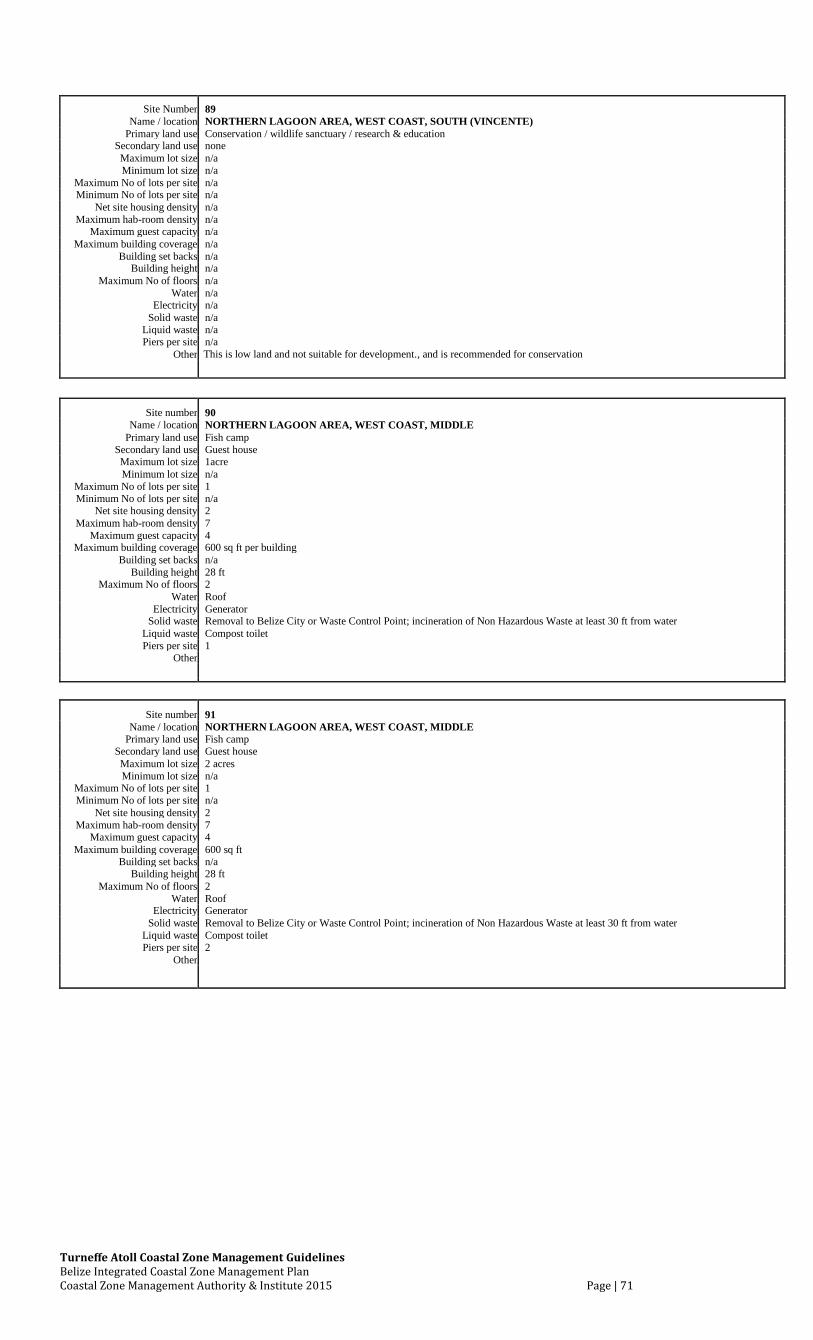
Turneffe Atoll Coastal Zone Management Guidelines Belize Integrated Coastal Zone Management Plan Coastal Zone Management Authority & Institute 2015 Page | 71
Site Number 89 Name / location NORTHERN LAGOON AREA, WEST COAST, SOUTH (VINCENTE)
Primary land use Conservation / wildlife sanctuary / research & education Secondary land use none Maximum lot size n/a Minimum lot size n/a
Maximum No of lots per site n/a Minimum No of lots per site n/a
Net site housing density n/a Maximum hab-room density n/a
Maximum guest capacity n/a Maximum building coverage n/a
Building set backs n/a Building height n/a
Maximum No of floors n/a Water n/a
Electricity n/a Solid waste n/a
Liquid waste n/a Piers per site n/a
Other This is low land and not suitable for development., and is recommended for conservation
Site number 90 Name / location NORTHERN LAGOON AREA, WEST COAST, MIDDLE
Primary land use Fish camp Secondary land use Guest house Maximum lot size 1acre Minimum lot size n/a
Maximum No of lots per site 1 Minimum No of lots per site n/a
Net site housing density 2 Maximum hab-room density 7
Maximum guest capacity 4 Maximum building coverage 600 sq ft per building
Building set backs n/a Building height 28 ft
Maximum No of floors 2 Water Roof
Electricity Generator Solid waste Removal to Belize City or Waste Control Point; incineration of Non Hazardous Waste at least 30 ft from water
Liquid waste Compost toilet Piers per site 1
Other
Site number 91 Name / location NORTHERN LAGOON AREA, WEST COAST, MIDDLE
Primary land use Fish camp Secondary land use Guest house Maximum lot size 2 acres Minimum lot size n/a
Maximum No of lots per site 1 Minimum No of lots per site n/a
Net site housing density 2 Maximum hab-room density 7
Maximum guest capacity 4 Maximum building coverage 600 sq ft
Building set backs n/a Building height 28 ft
Maximum No of floors 2 Water Roof
Electricity Generator Solid waste Removal to Belize City or Waste Control Point; incineration of Non Hazardous Waste at least 30 ft from water
Liquid waste Compost toilet Piers per site 2
Other
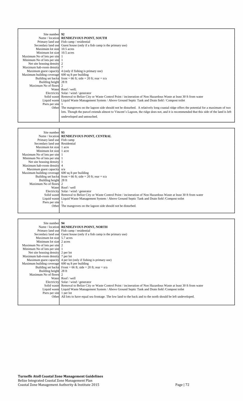
Turneffe Atoll Coastal Zone Management Guidelines Belize Integrated Coastal Zone Management Plan Coastal Zone Management Authority & Institute 2015 Page | 72
Site number 92 Name / location RENDEZVOUS POINT, SOUTH
Primary land use Fish camp / residential Secondary land use Guest house (only if a fish camp is the primary use) Maximum lot size 10.5 acres Minimum lot size 10.5 acres
Maximum No of lots per site 1 Minimum No of lots per site 1
Net site housing density 2 Maximum hab-room density 7
Maximum guest capacity 4 (only if fishing is primary use) Maximum building coverage 600 sq ft per building
Building set backs front = 66 ft; side = 20 ft; rear = n/a Building height 28 ft
Maximum No of floors 2 Water Roof / well;
Electricity Solar / wind / generator Solid waste Removal to Belize City or Waste Control Point / incineration of Non Hazardous Waste at least 30 ft from water
Liquid waste Liquid Waste Management System / Above Ground Septic Tank and Drain field / Compost toilet Piers per site 1
Other The mangroves on the lagoon side should not be disturbed. A relatively long coastal ridge offers the potential for a maximum of two
lots. Though the parcel extends almost to Vincent’s Lagoon, the ridge does not, and it is recommended that this side of the land is left
undeveloped and untouched.
Site number 93 Name / location RENDEZVOUS POINT, CENTRAL
Primary land use Fish camp Secondary land use Residential Maximum lot size 1 acre Minimum lot size 1 acre
Maximum No of lots per site 1 Minimum No of lots per site 1
Net site housing density 1 Maximum hab-room density 4
Maximum guest capacity n/a Maximum building coverage 600 sq ft per building
Building set backs front = 66 ft; side = 20 ft; rear = n/a Building height 28 ft
Maximum No of floors 2 Water Roof / well
Electricity Solar / wind / generator Solid waste Removal to Belize City or Waste Control Point / incineration of Non Hazardous Waste at least 30 ft from water
Liquid waste Liquid Waste Management System / Above Ground Septic Tank and Drain field /Compost toilet Piers per site 1
Other The mangroves on the lagoon side should not be disturbed.
Site number 94 Name / location RENDEZVOUS POINT, NORTH
Primary land use Fish camp / residential Secondary land use Guest house (only if a fish camp is the primary use) Maximum lot size 5.7 acres Minimum lot size 2 acres
Maximum No of lots per site 2 Minimum No of lots per site 1
Net site housing density 2 per lot Maximum hab-room density 7 per lot
Maximum guest capacity 4 per lot (only if fishing is primary use) Maximum building coverage 600 sq ft per building
Building set backs Front = 66 ft; side = 20 ft; rear = n/a Building height 28 ft
Maximum No of floors 2 Water Roof / well
Electricity Solar / wind / generator Solid waste Removal to Belize City or Waste Control Point / incineration of Non Hazardous Waste at least 30 ft from water
Liquid waste Liquid Waste Management System / Above Ground Septic Tank and Drain field /Compost toilet Piers per site 1 per lot
Other All lots to have equal sea frontage. The low land to the back and to the north should be left undeveloped.
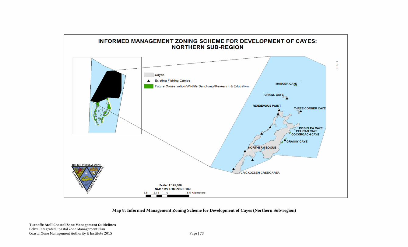
Turneffe Atoll Coastal Zone Management Guidelines Belize Integrated Coastal Zone Management Plan Coastal Zone Management Authority & Institute 2015 Page | 73
Map 8: Informed Management Zoning Scheme for Development of Cayes (Northern Sub-region)
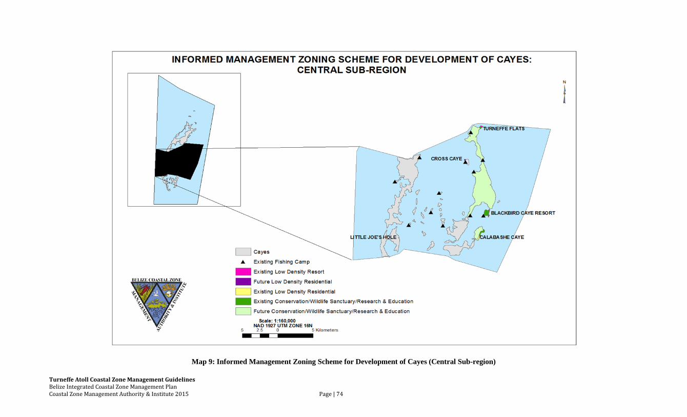
Turneffe Atoll Coastal Zone Management Guidelines Belize Integrated Coastal Zone Management Plan Coastal Zone Management Authority & Institute 2015 Page | 74
Map 9: Informed Management Zoning Scheme for Development of Cayes (Central Sub-region)
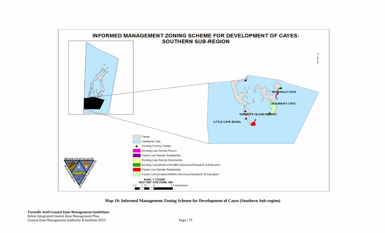
Turneffe Atoll Coastal Zone Management Guidelines Belize Integrated Coastal Zone Management Plan Coastal Zone Management Authority & Institute 2015 Page | 75
Map 10: Informed Management Zoning Scheme for Development of Cayes (Southern Sub-region)
Historically, the ‘lands’ at Turneffe Atoll, whether consisting of solid land, substantial
mangrove stands or over-wash mangrove swamp was, until recent years, predominantly national
land. Over the past two decades, an increasing number of properties have become privately
owned. In the early 1990’s, there was a moratorium on the sale of National cayes. This policy is
hereby supported and should be extended to include the cayes at Turneffe Atoll. Those lands
which are nationally owned should remain as such as this state of affairs provides the
opportunity for decision-makers to have greater input in land management concerns.
Transferable leases and land speculation have resulted in more land being transferred into
private ownership, and then foreign hands, resulting in little economic benefit for the people or
the Government of Belize. Where land is private property, the right to alienate and develop must
be recognized, but regulated to ensure that the subdivision of land subscribes to guidelines which
ensure that the resulting parcels can sustain the type of permitted development activity. The
seabed is national land and thus any proposals to develop the seabed or to construct piers within
this region need to receive clearance from the Lands Department and Department of
Environment.
The revised inventory of cayes for Turneffe Atoll indicating current land tenure was
completed in late 2002. However, since that time land tenure has changed dramatically. In 2002
there were 33 private properties, ranging in size from 500 square yards to 351 acres; 139
approved leases, ranging in size from 780 square yards to 85 acres; 33 lease applications that
have not yet been approved, and 12 cancelled leases. The 1992 Inventory of Cayes had
identified 103 leases. As this situation has changed so dramatically since 2002, an update of
Turneffe’s land tenure is essential.
Turneffe Atoll Coastal Zone Management Guidelines Belize Integrated Coastal Zone Management Plan Coastal Zone Management Authority & Institute 2015 Page | 77
Recommended Actions:
1. Reactivate the moratorium on the sale of small National Cayes and ask that it apply to
Turneffe Atoll
2. Establish a temporary moratorium on the sale of all National Land on Turneffe Atoll until
an integrated management structure is in place
3. Secure tenure (leases) for fishing camps that have been occupied on a long-term basis
4. Prioritize new leases for traditional fishermen at Turneffe Atoll
5. All lease conditions, transfers, and sub-divisions should conform to these guidelines
6. Prohibit over the water closed-structures on Turneffe Atoll; particularly those which
include bathroom facilities
7. Establish building height limitations for the Atoll with enforcement by a yet-to-be-
established management structure
8. Update Turneffe’s land tenure
9. Utilize Marine Spatial Planning methodologies such as Marine Invest, as they become
available, to better inform land use decisions and achieve the best possible sustainable
ecological, economic and social advantages for Belize.
Turneffe Atoll Coastal Zone Management Guidelines Belize Integrated Coastal Zone Management Plan Coastal Zone Management Authority & Institute 2015 Page | 78
6.4 Marine Dredging and Mineral Extraction
Turneffe Atoll has sufficient high land for resort and/or residential development. Thus
conversion of swamp into “beaches” or “land” is not needed for development of the Atoll.
Protection of Turneffe’s environment, particularly the reef, back-reef flats and seagrass beds, is
essential to the survival of its two major economic sectors - commercial fishing and tourism.
Dredging invariably destroys critical habitats for these enterprises - namely back-reef flats, sand
flats and seagrass beds. Additionally, Turneffe Atoll’s coral reefs are easily damaged by silt and
runoff from dredging. The reef system at Turneffe has been under increased stress in recent
years due to coral bleaching from climatic changes as well as damage from Hurricanes Mitch-
1998, Keith-2000 and Richard-2010. As a result, it is particularly important to limit significant
man-made stresses from activities such as dredging.
Recommended Actions:
1. Dredging conflicts with the all of the management objectives for Turneffe Atoll.
Therefore, no dredging, sand mining, or land filling, with the exception of limited hand
dredging around docks, should be allowed at Turneffe without 1) a comprehensive
Environmental Impact Assessment to include a vetting process involving relevant
stakeholders and 2) compliance with these Guidelines. .
2. In consideration of the objectives of these guidelines which include sustainability of
commercial fishing sector and support of low-impact, nature-based tourism, development
should be confined to areas naturally supportive of such development.
3. Any reclamation of lost property, (after hurricanes) should only be done in consultation
with the relevant authorities. Dredging for this purpose should be kept to a minimum
while guaranteeing that native habitats are not damaged.
4. Land without feasible access should not be developed and only minimal manual dredging
for boat access should be allowed. The cayes development sites table (Table 4) stipulates
the provisions for piers.
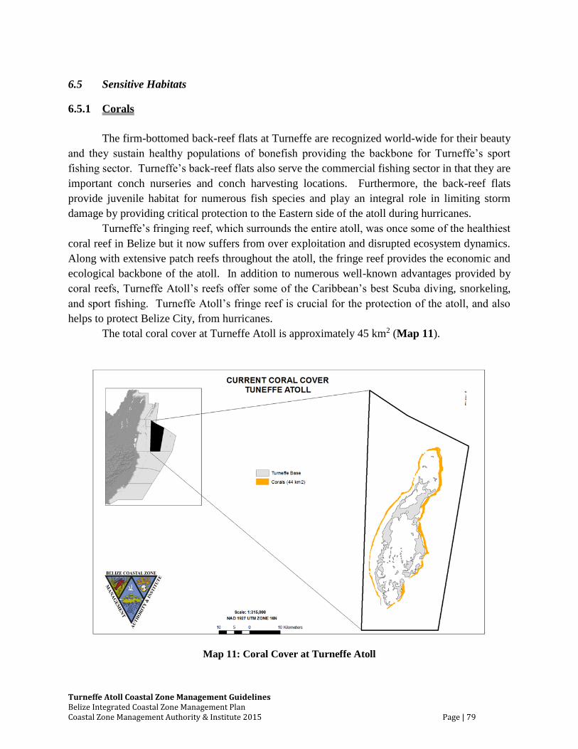
Turneffe Atoll Coastal Zone Management Guidelines Belize Integrated Coastal Zone Management Plan Coastal Zone Management Authority & Institute 2015 Page | 79
6.5 Sensitive Habitats
6.5.1 Corals
The firm-bottomed back-reef flats at Turneffe are recognized world-wide for their beauty
and they sustain healthy populations of bonefish providing the backbone for Turneffe’s sport
fishing sector. Turneffe’s back-reef flats also serve the commercial fishing sector in that they are
important conch nurseries and conch harvesting locations. Furthermore, the back-reef flats
provide juvenile habitat for numerous fish species and play an integral role in limiting storm
damage by providing critical protection to the Eastern side of the atoll during hurricanes.
Turneffe’s fringing reef, which surrounds the entire atoll, was once some of the healthiest
coral reef in Belize but it now suffers from over exploitation and disrupted ecosystem dynamics.
Along with extensive patch reefs throughout the atoll, the fringe reef provides the economic and
ecological backbone of the atoll. In addition to numerous well-known advantages provided by
coral reefs, Turneffe Atoll’s reefs offer some of the Caribbean’s best Scuba diving, snorkeling,
and sport fishing. Turneffe Atoll’s fringe reef is crucial for the protection of the atoll, and also
helps to protect Belize City, from hurricanes.
The total coral cover at Turneffe Atoll is approximately 45 km2 (Map 11).
Map 11: Coral Cover at Turneffe Atoll
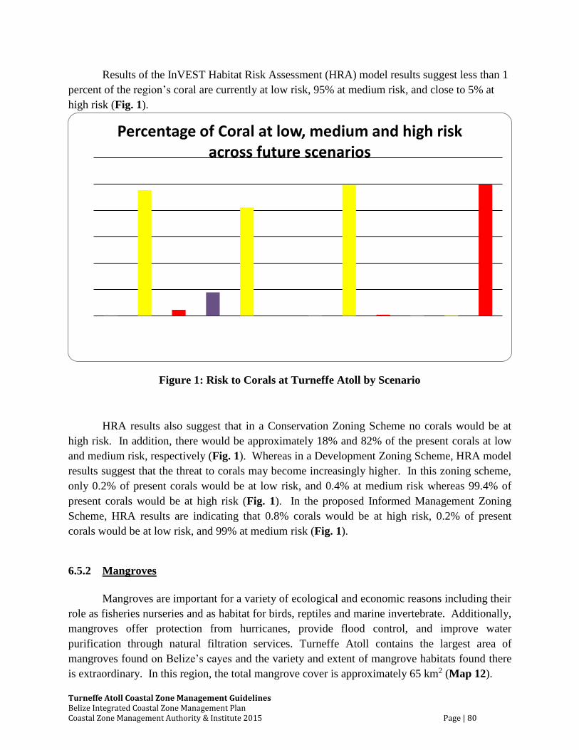
Turneffe Atoll Coastal Zone Management Guidelines Belize Integrated Coastal Zone Management Plan Coastal Zone Management Authority & Institute 2015 Page | 80
Results of the InVEST Habitat Risk Assessment (HRA) model results suggest less than 1
percent of the region’s coral are currently at low risk, 95% at medium risk, and close to 5% at
high risk (Fig. 1).
Figure 1: Risk to Corals at Turneffe Atoll by Scenario
HRA results also suggest that in a Conservation Zoning Scheme no corals would be at
high risk. In addition, there would be approximately 18% and 82% of the present corals at low
and medium risk, respectively (Fig. 1). Whereas in a Development Zoning Scheme, HRA model
results suggest that the threat to corals may become increasingly higher. In this zoning scheme,
only 0.2% of present corals would be at low risk, and 0.4% at medium risk whereas 99.4% of
present corals would be at high risk (Fig. 1). In the proposed Informed Management Zoning
Scheme, HRA results are indicating that 0.8% corals would be at high risk, 0.2% of present
corals would be at low risk, and 99% at medium risk (Fig. 1).
6.5.2 Mangroves
Mangroves are important for a variety of ecological and economic reasons including their
role as fisheries nurseries and as habitat for birds, reptiles and marine invertebrate. Additionally,
mangroves offer protection from hurricanes, provide flood control, and improve water
purification through natural filtration services. Turneffe Atoll contains the largest area of
mangroves found on Belize’s cayes and the variety and extent of mangrove habitats found there
is extraordinary. In this region, the total mangrove cover is approximately 65 km2 (Map 12).
Percentage of Coral at low, medium and high risk across future scenarios
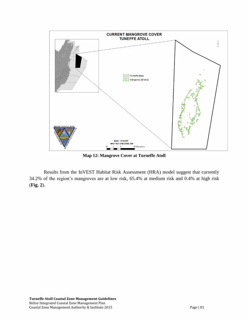
Turneffe Atoll Coastal Zone Management Guidelines Belize Integrated Coastal Zone Management Plan Coastal Zone Management Authority & Institute 2015 Page | 81
Map 12: Mangrove Cover at Turneffe Atoll
Results from the InVEST Habitat Risk Assessment (HRA) model suggest that currently
34.2% of the region’s mangroves are at low risk, 65.4% at medium risk and 0.4% at high risk
(Fig. 2).
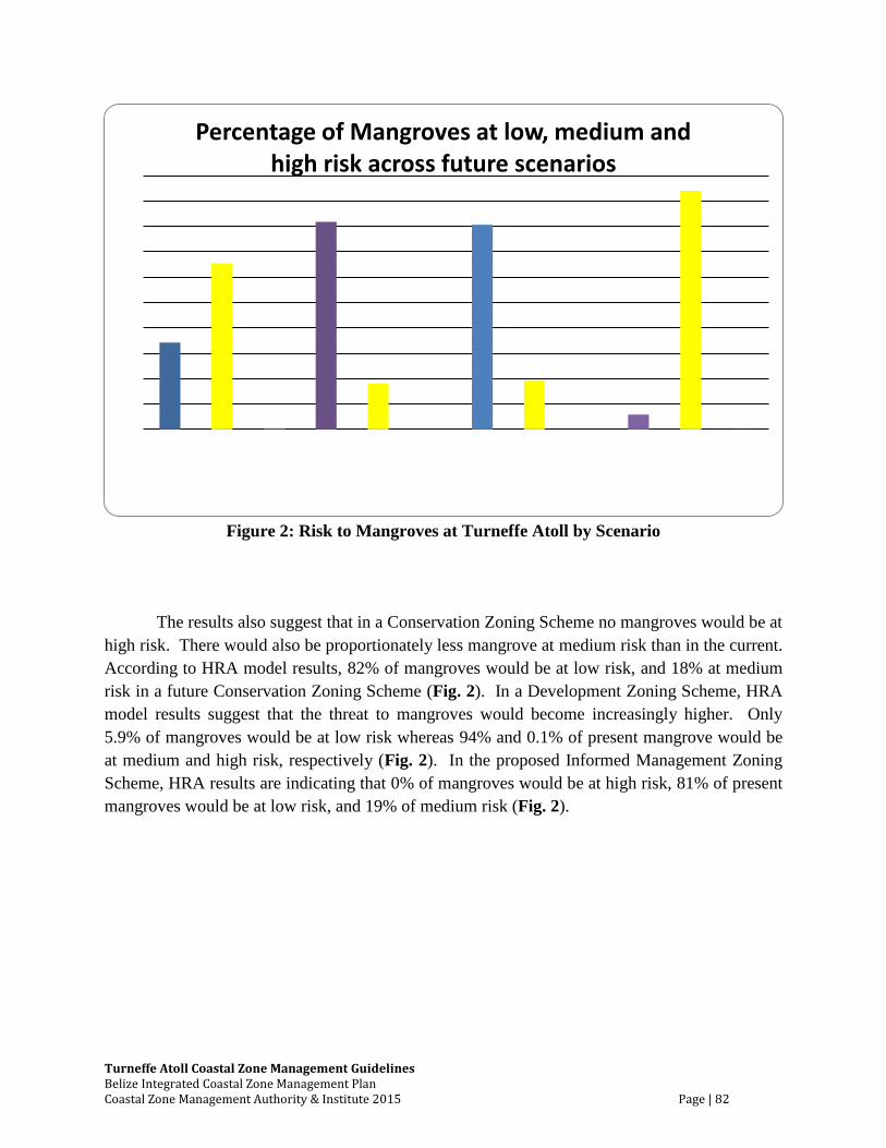
Turneffe Atoll Coastal Zone Management Guidelines Belize Integrated Coastal Zone Management Plan Coastal Zone Management Authority & Institute 2015 Page | 82
Figure 2: Risk to Mangroves at Turneffe Atoll by Scenario
The results also suggest that in a Conservation Zoning Scheme no mangroves would be at
high risk. There would also be proportionately less mangrove at medium risk than in the current.
According to HRA model results, 82% of mangroves would be at low risk, and 18% at medium
risk in a future Conservation Zoning Scheme (Fig. 2). In a Development Zoning Scheme, HRA
model results suggest that the threat to mangroves would become increasingly higher. Only
5.9% of mangroves would be at low risk whereas 94% and 0.1% of present mangrove would be
at medium and high risk, respectively (Fig. 2). In the proposed Informed Management Zoning
Scheme, HRA results are indicating that 0% of mangroves would be at high risk, 81% of present
mangroves would be at low risk, and 19% of medium risk (Fig. 2).
Percentage of Mangroves at low, medium and high risk across future scenarios
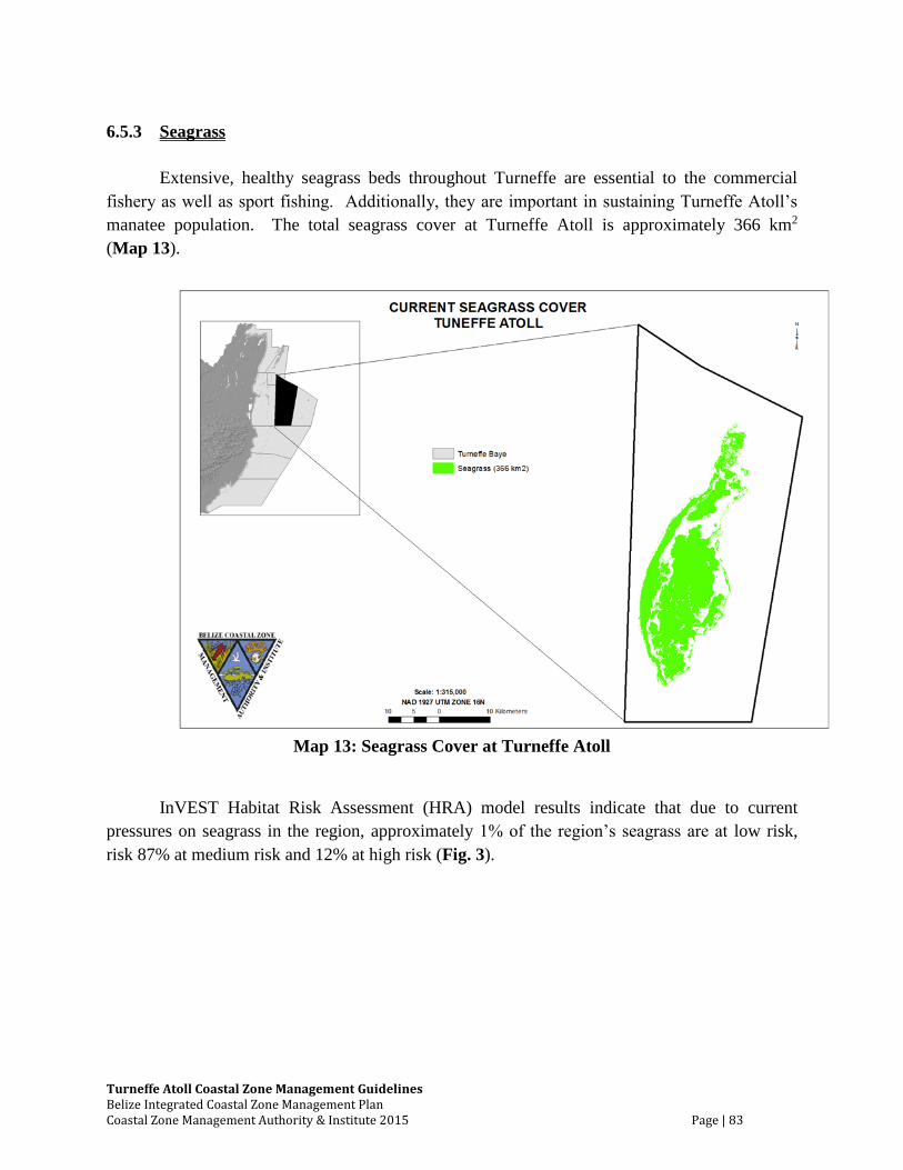
Turneffe Atoll Coastal Zone Management Guidelines Belize Integrated Coastal Zone Management Plan Coastal Zone Management Authority & Institute 2015 Page | 83
6.5.3 Seagrass
Extensive, healthy seagrass beds throughout Turneffe are essential to the commercial
fishery as well as sport fishing. Additionally, they are important in sustaining Turneffe Atoll’s
manatee population. The total seagrass cover at Turneffe Atoll is approximately 366 km2
(Map 13).
Map 13: Seagrass Cover at Turneffe Atoll
InVEST Habitat Risk Assessment (HRA) model results indicate that due to current
pressures on seagrass in the region, approximately 1% of the region’s seagrass are at low risk,
risk 87% at medium risk and 12% at high risk (Fig. 3).
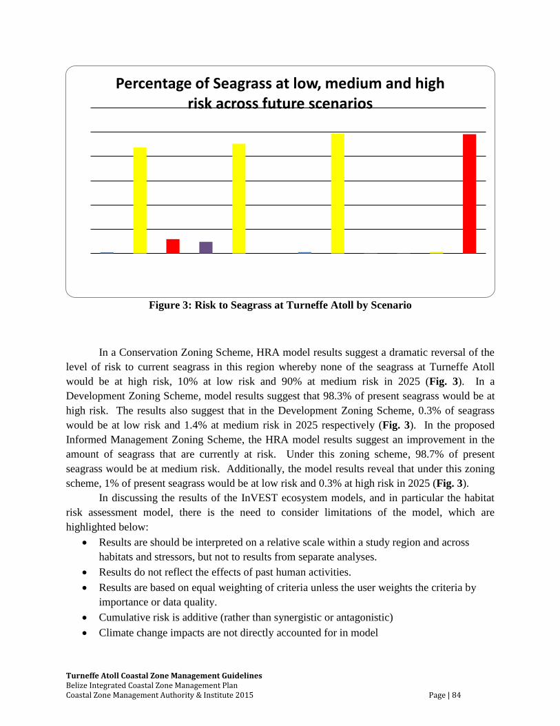
Turneffe Atoll Coastal Zone Management Guidelines Belize Integrated Coastal Zone Management Plan Coastal Zone Management Authority & Institute 2015 Page | 84
Figure 3: Risk to Seagrass at Turneffe Atoll by Scenario
In a Conservation Zoning Scheme, HRA model results suggest a dramatic reversal of the
level of risk to current seagrass in this region whereby none of the seagrass at Turneffe Atoll
would be at high risk, 10% at low risk and 90% at medium risk in 2025 (Fig. 3). In a
Development Zoning Scheme, model results suggest that 98.3% of present seagrass would be at
high risk. The results also suggest that in the Development Zoning Scheme, 0.3% of seagrass
would be at low risk and 1.4% at medium risk in 2025 respectively (Fig. 3). In the proposed
Informed Management Zoning Scheme, the HRA model results suggest an improvement in the
amount of seagrass that are currently at risk. Under this zoning scheme, 98.7% of present
seagrass would be at medium risk. Additionally, the model results reveal that under this zoning
scheme, 1% of present seagrass would be at low risk and 0.3% at high risk in 2025 (Fig. 3).
In discussing the results of the InVEST ecosystem models, and in particular the habitat
risk assessment model, there is the need to consider limitations of the model, which are
highlighted below:
Results are should be interpreted on a relative scale within a study region and across
habitats and stressors, but not to results from separate analyses.
Results do not reflect the effects of past human activities.
Results are based on equal weighting of criteria unless the user weights the criteria by
importance or data quality.
Cumulative risk is additive (rather than synergistic or antagonistic)
Climate change impacts are not directly accounted for in model
Percentage of Seagrass at low, medium and high risk across future scenarios
Turneffe Atoll Coastal Zone Management Guidelines Belize Integrated Coastal Zone Management Plan Coastal Zone Management Authority & Institute 2015 Page | 85
Additional information on how this model works can be found in Appendix B.1 of the
Belize Integrated Coastal Zone Management Plan
Recommended Actions:
1. Due to the importance of mangroves as providers of ecological services for Turneffe
Atoll and their value to its major industries (fishing and tourism), mangrove removal
should be minimized and the Mangrove Protection Act of 1989 should be updated and
strictly enforced.
2. Clearing of vegetation should be kept to a minimum and valuable littoral forest should be
identified with GPS coordinates, clearly mapped and zoned for protection.
3. Some palmettos stands are selectively used for lobster trap construction and this use is
sustainable in its present volume, although management may be required in the future.
4. Preservation of seagrass beds should be a priority in all management decisions at
Turneffe Atoll.
5. Due to the economic and ecological importance or Turneffe’s fringe reef, patch reef and
back-reef flats, management of Turneffe Atoll should ensure that the integrity and health
of these areas is carefully protected.
6. Modern planning methodologies should be used to further analyze, and presumably
confirm, the economic, ecological and social value of preserving the unique and special
areas at Turneffe Atoll.
Turneffe Atoll Coastal Zone Management Guidelines Belize Integrated Coastal Zone Management Plan Coastal Zone Management Authority & Institute 2015 Page | 86
6.6 Utilities
Because of remote location of the atoll, the availability of fresh water and electricity are
major obstacles for development and also serve as potential sources of environmental
degradation. These guidelines seek to ensure that proper consideration is given to the
environmental consequences of providing these utilities. The level of need and their resultant
potential for impact fall into at least three categories: fishing camps, tourism development and
residential development. In general, fishing camps are sparely populated and require minimal
utility infrastructure while tourism and residential developments require more advanced
infrastructure.
In terms of marine transportation, the Belize Port Authority maintains two lighthouses at
Turneffe Atoll, one at Dog Flea Caye to the North and another at Caye Bokel to the south. The
Belize Port Authority is mandated to ensure the safety of navigational channels, through the
installation of navigational aids (Belize Port Authority Act, 1976; revised, 2003) and installation
and maintenance of demarcation buoys. It also has a role in the registration of boats and
monitoring of vessels using navigational channels and the removal of boats from the reef, when
groundings occur. These guidelines recognize existing marine transportation routes around the
atoll, which have been captured in the spatial zoning scheme (Map 14). In addition to the
recommended actions below, implementation of the framework for enforcing the recommended
transportation routes for this region (Table 5) is strongly recommended.
Recommended Actions:
1. Tourism and residential developments should be required to provide detailed plans about
how they will provide adequate fresh water which will not degrade natural fresh water
resources used by wildlife.
2. Rainwater collection, recycling of gray water, and other water preservation methods,
should be utilized as much as possible.
3. Maximal use of solar and wind power is recommended, yet it is recognized that some fuel
based power will be necessary.
4. Power requirements should be minimized to the extent possible through the use of power-
saving measures and other efficiencies.
5. As transportation and storage of fossil fuels present risks of serious contamination,
adequate policies and procedures for these activities should be required and approved for
all residential and tourism developments.
Turneffe Atoll Coastal Zone Management Guidelines Belize Integrated Coastal Zone Management Plan Coastal Zone Management Authority & Institute 2015 Page | 87
6. Fuel related contaminants must be disposed of responsibly and all tourism and residential
development proposals should include responsible plans for these processes.
7. Transportation, distribution and disposal of fuel products should be monitored for all
tourism and residential developments ensuring that appropriate standards are followed,
possibly by a Turneffe management entity or the DOE.
8. Generating systems should be shared by neighboring developments whenever feasible.
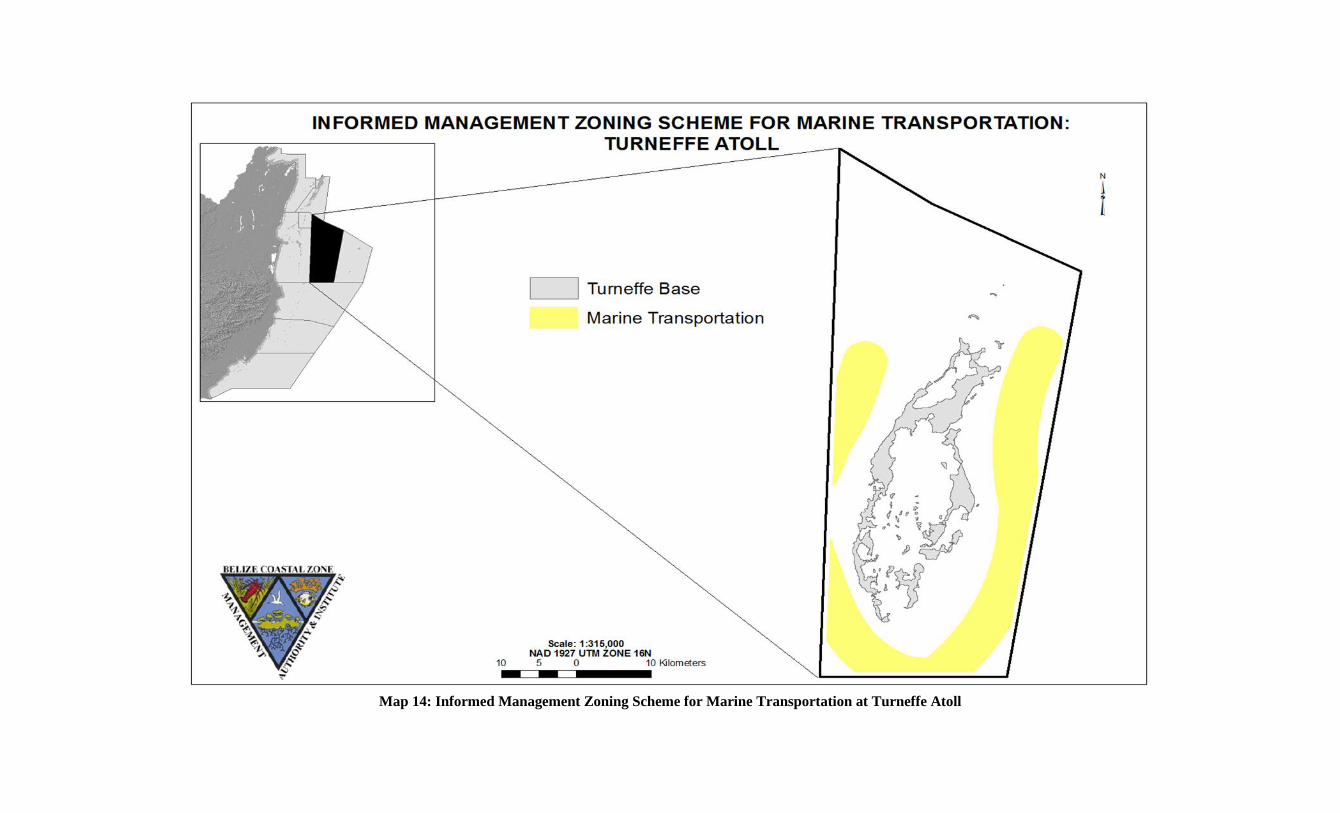
Map 14: Informed Management Zoning Scheme for Marine Transportation at Turneffe Atoll
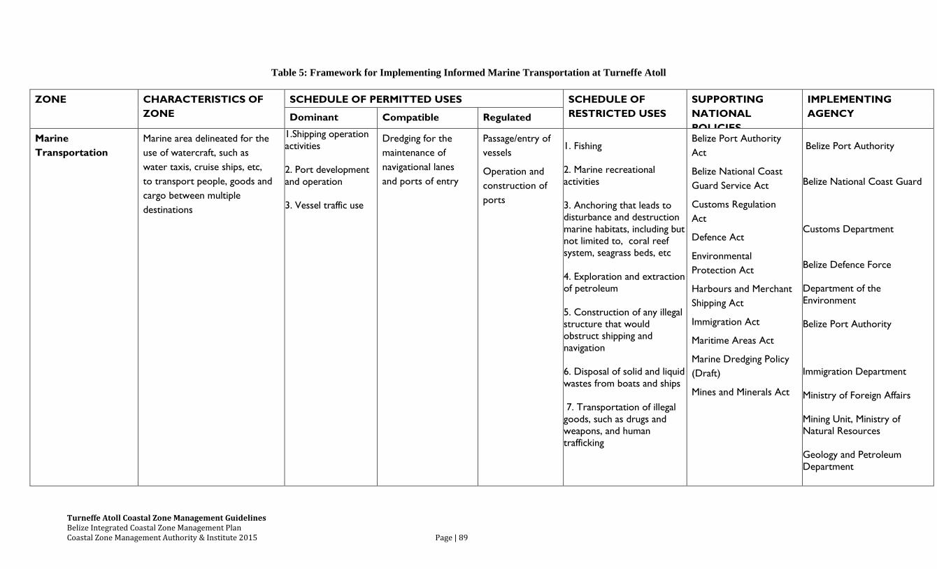
Turneffe Atoll Coastal Zone Management Guidelines Belize Integrated Coastal Zone Management Plan Coastal Zone Management Authority & Institute 2015 Page | 89
Table 5: Framework for Implementing Informed Marine Transportation at Turneffe Atoll
ZONE CHARACTERISTICS OF
ZONE
SCHEDULE OF PERMITTED USES SCHEDULE OF
RESTRICTED USES
SUPPORTING
NATIONAL
POLICIES
IMPLEMENTING
AGENCY Dominant Compatible Regulated
Marine
Transportation
Marine area delineated for the
use of watercraft, such as
water taxis, cruise ships, etc,
to transport people, goods and
cargo between multiple
destinations
1.Shipping operation
activities
2. Port development
and operation
3. Vessel traffic use
Dredging for the
maintenance of
navigational lanes
and ports of entry
Passage/entry of
vessels
Operation and
construction of
ports
1. Fishing
2. Marine recreational
activities
3. Anchoring that leads to
disturbance and destruction
marine habitats, including but
not limited to, coral reef
system, seagrass beds, etc
4. Exploration and extraction
of petroleum
5. Construction of any illegal
structure that would
obstruct shipping and
navigation
6. Disposal of solid and liquid
wastes from boats and ships
7. Transportation of illegal
goods, such as drugs and
weapons, and human
trafficking
Belize Port Authority
Act
Belize National Coast
Guard Service Act
Customs Regulation
Act
Defence Act
Environmental
Protection Act
Harbours and Merchant
Shipping Act
Immigration Act
Maritime Areas Act
Marine Dredging Policy
(Draft)
Mines and Minerals Act
Belize Port Authority
Belize National Coast Guard
Customs Department
Belize Defence Force
Department of the
Environment
Belize Port Authority
Immigration Department
Ministry of Foreign Affairs
Mining Unit, Ministry of
Natural Resources
Geology and Petroleum
Department
6.7 Pollution Control
The matter of pollution control is addressed in much the same manner as utilities with
recommendations for tourism and residential development not being as strict as those required
for fishing camps. This is based on occupation levels with tourism and residential developments
generating far more waste. Due to the fragile nature of the atolls underground septic tanks and
soakaways are not recommended as a means of handling liquid wastes. Several of the
development sites (Table 4) recommend the use of above-ground septic tanks with drain fields.
The Central Building Authority (CBA), is the agency mandated by the Belize Building Act 2003
to control building operations in the interest of public safety and health. In 2010, CBA produced
detailed specifications for the construction of soakaways and septic tanks for residential and
other low-impact buildings. CZMAI recommends that developers must consult with the CBA on
standards for the construction of above-ground septic tanks with drain fields.
Recommended Actions:
1. Procedures to minimize waste should be in place for all developments and recycling
should be utilized as much as possible. On-site waste disposal should be accomplished in
a manner consistent with the National Solid Waste Management Guidelines.
2. For tourism and residential developments, solid waste from toilets should be treated by
means of an earth tub or similar type technology with the resulting compost used in
landscaping. Open septic tanks should not be permitted for tourism or residential
facilities and closed septic tank/drain-field systems should be permitted only with pre-
approval from the Department of the Environment and Central Building Authority.
3. Gray water should be recycled and reused as much as possible.
4. Food waste from tourism and residential properties should be composted and used on-site
as fertilizer.
5. All hazardous waste, including batteries, tires, propellant cans and petroleum-based
products, should be properly stored to avoid contamination and transported to the
mainland for final disposal.
6. Metal containers should be used for incinerating burnable inorganic waste, although such
incineration should be done in a manner that is not a nuisance to neighbors. Large-scale
resorts (yet to be defined) should be required to utilize incinerators for these purposes.
Turneffe Atoll Coastal Zone Management Guidelines Belize Integrated Coastal Zone Management Plan Coastal Zone Management Authority & Institute 2015 Page | 91
7. For fishing camps, the volume of solid waste generated is small enough that incineration
on site, given adequate precautions, should be acceptable. If a fishing camp develops a
‘guest house’, however, it should then conform to the recommendations above.
8. Open latrines should be used only in fish camps where the occupancy is minimal, i.e. 2-3
people. If a fishing camp develops a ‘guest house’, they should then conform to the
recommendations above.
9. In an effort to reduce and prevent the environmental impacts associated with the disposal
of waste products, the operators of cruise ships and other vessels should comply with the
national recommendations in the Belize Integrated Coastal Zone Management Plan.
Turneffe Atoll Coastal Zone Management Guidelines Belize Integrated Coastal Zone Management Plan Coastal Zone Management Authority & Institute 2015 Page | 92
6.8 Social Amenities and Recreation
Given the remote location of the Atoll and its relatively large and sparely inhabited area,
basic social amenities are largely unavailable. Furthermore, many inhabitants have very limited
access to communication, even for emergencies.
Health care facilities are not available on the atoll. Depending upon the weather and
other circumstances, access to emergency health care can be nearly impossible. Presently, no
portion of the atoll is designated for general public recreation for day visitors or cruise ship
visitors.
Recommendations:
1. Because there are no basic health care facilities on the atoll, all residents should be
prepared to provide at least basic medical care and resorts are encouraged to provide
assistance to the wider community when needed.
2. Recommendations for the provision for disaster risk management and emergency
evacuation services of inhabitants should be implemented as per prescribed in the
Turneffe Atoll Management Plan 2012-2017.
3. The University of Belize, on Calabash Caye or other suitable facilities, should be used for
meetings of the general community or specific groups/committees on the islands.
4. Public recreational areas, with infrastructure such as pier and bathroom facilities, should
be established facilitate day-trip tourism at suitable sites on Turneffe. Financial support
from interested and willing conservation agencies nationally and internationally, as well
user fees generated from the Turneffe Atoll Marine Reserve could help to establish and
oversee this recommendation.
5. Large vessels, including cruise ships, should only be allowed at sites or in harbors
designated by the Belize Port Authority. Near the reef, vessels must moor at sites
designated by the Fisheries Department where adequate mooring facilities have been
installed. Tender vessels associated with the operations of large vessels will not be
allowed to drop anchor where the anchor, chain or any part of the vessel could cause
damage to the reef. In the event that the cruise ships or other vessels are to be anchored
in the vicinity of the atolls or reef, permanent-mooring sites must be established for this
purpose in consultation with the Fisheries Department and the Belize Port Authority.
Turneffe Atoll Coastal Zone Management Guidelines Belize Integrated Coastal Zone Management Plan Coastal Zone Management Authority & Institute 2015 Page | 93
6.9 Conservation
Turneffe Atoll is unique in that it is one of the few atolls in the Caribbean containing
excellent reef development around its margins as well extensive back-reef flats and intact
mangrove and seagrass habitat in its interior. It is also the largest of the four atolls in
Mesoamerica. The reefs and hard-bottom communities support a diverse assemblage of corals,
sponges, and fish. At least six critical fish spawning sites are known to exist around the atoll,
including sites for the endangered Nassau grouper.
Turneffe contains some of the best remaining habitat for the American salt-water
crocodile in the Caribbean, with perhaps the largest population in Belize of this endangered
species. Sea turtles nest on the sandy beaches of the eastern cayes. Dolphins and the endangered
Antillean manatee regularly frequent the interior network of mangrove cayes, creeks and
lagoons. Several species believed to be endemic to Belize, including Belize’s atoll gecko and the
rare white-spotted toadfish, are found at Turneffe Atoll.
Caye littoral forest is likely the most threatened coastal habitat in the world and the
eastern side of Turneffe Atoll is an especially important area for littoral forest. Littoral forest
refers to forested areas along the coast or cayes that generally occurs on the higher land. Littoral
forest has distinctive plant assemblages such as red and white gumbo limbo, sea grape,
poisonwood, Matapalo fig, sapodilla, numerous shrubs and other flowering plants, which support
a diverse assemblage of birds and insects
In the early 1990’s, the Turneffe Islands Committee Plan identified a number of
terrestrial areas to be reserved due to their high conservation value and these were confirmed by
the Coastal Zone Management Authority and Institute in 1999. A GAP analysis by Meerman, et
al in 2005 identified Turneffe Atoll as one of the largest remaining marine gaps within the
National Protected Areas System Plan and several NGO’s have listed Turneffe Atoll as a top
conservation priority. In 2008, Turneffe Atoll was highlighted as a regional gap and priority in
the Mesoamerican Reef Eco-regional Assessment.
Up until 2012, Turneffe Atoll had the unfortunate distinction of being the only atoll in the
Belize Barrier Reef System without significant protection or management. Although
recommendations and justifications for protection and management have been made since the
mid 1990’s, only two offshore spawning aggregation sites, “The Elbow” and Dog Flea Caye,
were declared as marine protected areas. The atoll was officially declared a marine reserve in
November 2012, not the largest in the country, and equipped with a fully functional management
plan.
In an effort to support continued national efforts to conserve the marine biological
diversity at Turneffe Atoll and reduce the pressures that could potentially impact the atoll, the
CZMAI supports the existing spatial management zoning scheme for Turneffe Atoll (Map 15)..
The recommended supporting framework for implementing the Informed Management Zoning
Scheme for Conservation at Turneffe Atoll is found in Table 6.
Turneffe Atoll Coastal Zone Management Guidelines Belize Integrated Coastal Zone Management Plan Coastal Zone Management Authority & Institute 2015 Page | 94
Recommended Actions:
1. The following recommendations for specific conservation sites are to be reserved.
Soldier Caye - a nesting site for the roseate tern, least tern and white crowned
pigeon;
Grassy Caye - a nesting site for turtles, the roseate and least tern as well as flats for
bonefish and juvenile conch;
Portions of Blackbird, Deadman’s and Calabash cayes - important nesting sites for
the endangered American crocodile and turtles;
Vincent’s (or Northern) Lagoon, the Freshwater Creek area, Pelican Caye, the
Crayfish Range in Central Lagoon, Sheg Caye / Cross Caye, Cockroach Caye
Range, and Douglas Caye;
Mauger Caye which is the site of a historic lighthouse.
2. Turneffe’s important conservation sites should be mapped and prioritized and this should
include mapping of critical manatee, crocodile, turtle, dolphin and other wildlife areas.
3. National land lying outside of the identified provisional development sites should not be
developed pending further evaluation including Spatial Marine Planning.
4. Policies should be initiated to further protect Turneffe’s endangered and threatened
species including the Antillean manatee, Hawksbill turtle, goliath grouper, Nassau
grouper, and American crocodile. Known manatee areas should be marked with signage
alerting boaters to their presence and appropriate no-wake zones should be established.
5. Dogs, cats and other domesticated animals should be contained so as not to disturb
wildlife.
6. Implement management recommendations and framework for conservation in these
guidelines in coordination with the recommendations in the Turneffe Atoll Management
Plan (2012-2017)
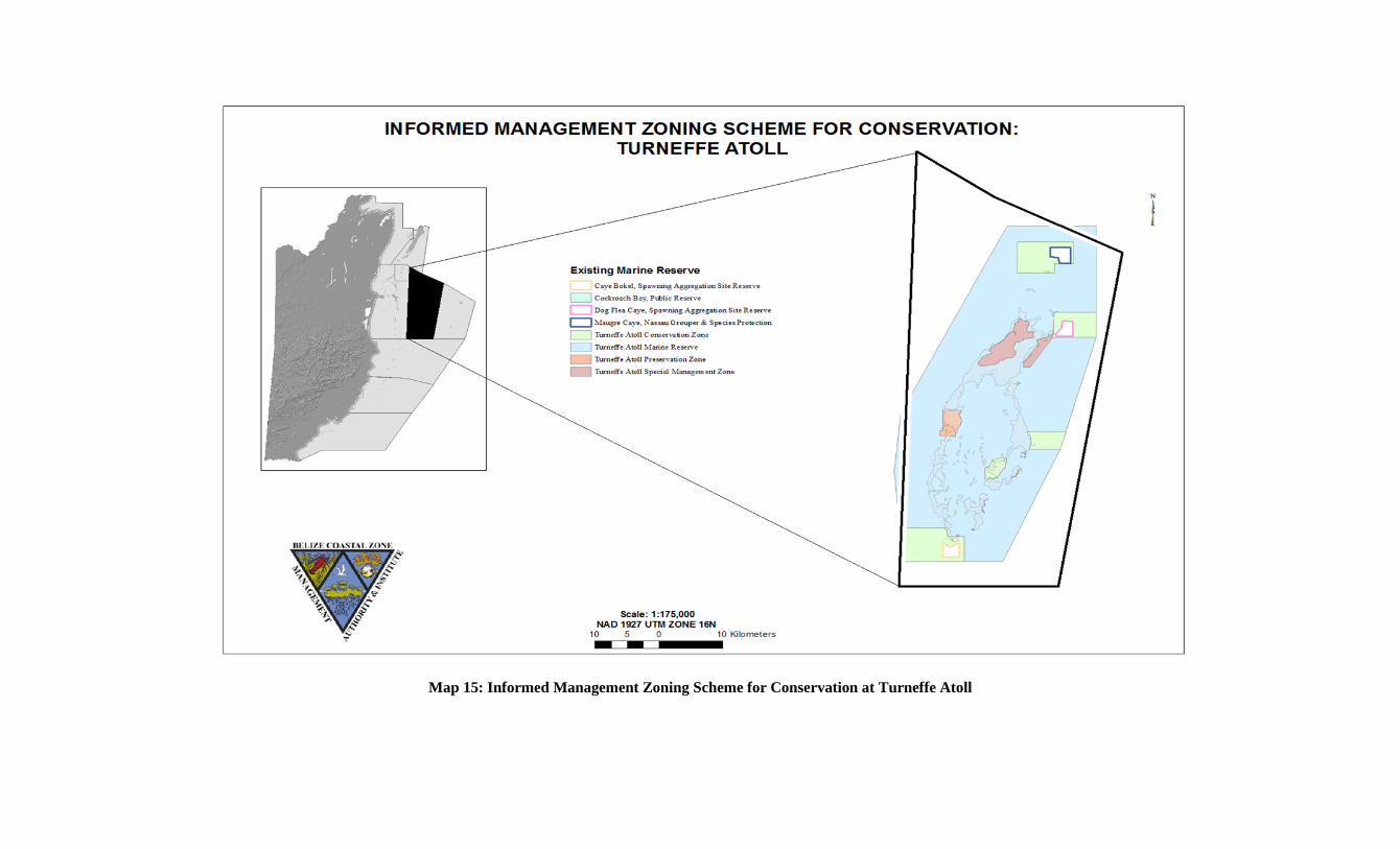
Map 15: Informed Management Zoning Scheme for Conservation at Turneffe Atoll
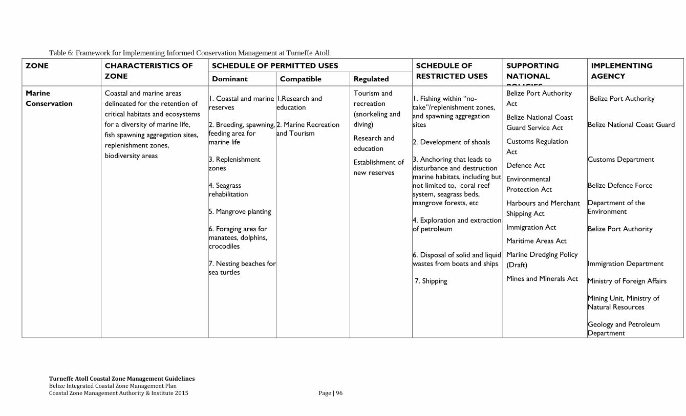
Turneffe Atoll Coastal Zone Management Guidelines Belize Integrated Coastal Zone Management Plan Coastal Zone Management Authority & Institute 2015 Page | 96
Table 6: Framework for Implementing Informed Conservation Management at Turneffe Atoll
ZONE CHARACTERISTICS OF
ZONE
SCHEDULE OF PERMITTED USES SCHEDULE OF
RESTRICTED USES
SUPPORTING
NATIONAL
POLICIES
IMPLEMENTING
AGENCY Dominant Compatible Regulated
Marine
Conservation
Coastal and marine areas
delineated for the retention of
critical habitats and ecosystems
for a diversity of marine life,
fish spawning aggregation sites,
replenishment zones,
biodiversity areas
1. Coastal and marine
reserves
2. Breeding, spawning,
feeding area for
marine life
3. Replenishment
zones
4. Seagrass
rehabilitation
5. Mangrove planting
6. Foraging area for
manatees, dolphins,
crocodiles
7. Nesting beaches for
sea turtles
1.Research and
education
2. Marine Recreation
and Tourism
Tourism and
recreation
(snorkeling and
diving)
Research and
education
Establishment of
new reserves
1. Fishing within “no-
take”/replenishment zones,
and spawning aggregation
sites
2. Development of shoals
3. Anchoring that leads to
disturbance and destruction
marine habitats, including but
not limited to, coral reef
system, seagrass beds,
mangrove forests, etc
4. Exploration and extraction
of petroleum
6. Disposal of solid and liquid
wastes from boats and ships
7. Shipping
Belize Port Authority
Act
Belize National Coast
Guard Service Act
Customs Regulation
Act
Defence Act
Environmental
Protection Act
Harbours and Merchant
Shipping Act
Immigration Act
Maritime Areas Act
Marine Dredging Policy
(Draft)
Mines and Minerals Act
Belize Port Authority
Belize National Coast Guard
Customs Department
Belize Defence Force
Department of the
Environment
Belize Port Authority
Immigration Department
Ministry of Foreign Affairs
Mining Unit, Ministry of
Natural Resources
Geology and Petroleum
Department
6.10 Scientific Research and Education
As a relatively isolated area which encompasses all key aspects of a coastal marine eco-
system, Turneffe Atoll is an ideal location for coastal marine research. For several decades
Turneffe Atoll has served as the location for important research related to coral reefs, manatees,
crocodiles, bonefish, permit and many other species with a number of monitoring and research
projects currently underway.
The University of Belize’s Institute of Marine Studies (IMS) on Calabash Caye is the
preeminent marine research facility in Belize and IMS has expanded its educational and research
focus at Turneffe Atoll in recent years. Additionally, the Oceanic Society, on the South end of
Blackbird Caye, has operated primarily as a research, monitoring and educational facility doing
important research on Turneffe’s marine mammals and reptiles.
Recommended Actions:
1. The notable ability of Turneffe Atoll as a resource for coastal marine education and
research should be embraced and promoted.
2. The biodiversity and interconnected coastal-marine habitats of the atoll should be
carefully considered in management decisions to ensure the health of all aspects of the
ecosystem with special consideration given to biological corridors.
3. The importance of ongoing monitoring and research to evaluate the effects of all
influences on the atoll should be recognized and supported.
4. Additional studies related to bird distribution, nesting and flight paths as well as
sustainable fisheries management and numerous other topics should be encouraged.
Turneffe Atoll Coastal Zone Management Guidelines Belize Integrated Coastal Zone Management Plan Coastal Zone Management Authority & Institute 2015 Page | 98
7.0 IMPLEMENTATION STRATEGY
The Turneffe Atoll Coastal Zone Management Guidelines form a part of the Belize
Integrated Coastal Zone Management Plan being developed by the CZMAI. After approval of
the Plan by CZMAI’s Board of Directors, it will be offered to the House of Representatives for
endorsement. Implementation of these coastal management guidelines will be undertaken
through two mechanisms: (a) centralized statutory control through the various Government
departments, and (b) localized community and stakeholder participation. Following the
mechanism of centralized statutory control, the regulatory and permitting agencies with
management mandates for the coastal zone will implement the specific policy actions and
informed management spatial zoning scheme that are recommended in the Plan.
While the government agencies have the authority of the law to back up its procedures, it
is constrained by limited resources. In several instances, however, local NGOs and community-
based stakeholder organizations have greater access to, and knowledge of, local conditions and
activities, though they have no statutory powers to either assist or control development beyond
those available through the Village Councils and Towns Councils Acts. For this reason, it is
recommended that localized community and stakeholder participation complement the
management efforts of centralized government and statutory agencies in implementing integrated
coastal zone management. The Turneffe Atoll Coastal Advisory Committee (TACAC), and
other interested stakeholders of this region, will work closely with the Coastal Zone Advisory
Council (CZAC) regarding monitoring and implementation of the guidelines.
Objectives of the Turneffe Atoll CAC include, inter alia, contributing to the drafting of
the coastal zone management guidelines for their coastal region, supporting their initial approval,
and monitoring and reporting to the Coastal Zone Advisory Council (CZAC) on the
implementation of the guidelines. This means that the Committee will be expected to undertake
the following tasks:
1. Develop, assess and approve the draft guidelines;
2. Forward the approved draft guidelines to CZMAI for approval;
3. Monitor the implementation and effectiveness of the guidelines;
4. Identify the appropriate time for a review of all or part of the guidelines;
5. Review and update the guidelines.
Planning is a continual process of recommendation, participation, implementation and
review. These guidelines shall be monitored on a continual basis in order to establish its
strengths and weaknesses. Through a management planning mechanism, the TACAC, along
with CZMAI, will regularly update the guidelines, which will hopefully set a good example of
Turneffe Atoll Coastal Zone Management Guidelines Belize Integrated Coastal Zone Management Plan Coastal Zone Management Authority & Institute 2015 Page | 99
representative, cooperative and adaptive management that is environmentally sound, rational and
equitable.
Additional studies are needed in liaison with the relevant authorities and region’s
stakeholders. Such studies should reveal information which may help to further support
sustainable development and to address the social, cultural and economic human use of the
region and its resources.
Turneffe Atoll Coastal Zone Management Guidelines Belize Integrated Coastal Zone Management Plan Coastal Zone Management Authority & Institute 2015 Page | 100
8.0 CONCLUSIONS
The coastal zone management guidelines recommended for the Turneffe Atoll are not
intended to be rigid, as changing socio-economic, cultural and environmental conditions may
necessitate modifications. Noteworthy, however, these guidelines and Informed Management
spatial zoning scheme have identified sites for specific human uses of the coastal zone, and the
disqualification of sites for not conducive to sustainable development. It is hopeful that the
objectives outlined at the beginning can be realized through the recommended sector policies
guidelines and spatially-explicit zoning scheme as they will ensure the sustainable use and
development of the Turneffe Atoll.
Turneffe Atoll Coastal Zone Management Guidelines Belize Integrated Coastal Zone Management Plan Coastal Zone Management Authority & Institute 2015 Page | 101
9.0 REFERENCES
Belize Tourism Board. 2008. Travel and Tourism Statistics. Belize City, Belize.
Belize Tourism Board. 2011. National Sustainable Tourism Master Plan for Belize 2030.
Available from http://www.sustainabletourismbz.org/dmdocfree/final_compiled_plan.pdf
(accessed June 2012)
Cho, L. 2005. Marine Protected Areas: A tool for integrated coastal management in Belize.
Ocean and Coastal Management 48: 932-947.
Coastal Zone Management Authority and Institute (CZMAI). 2001. Cayes Development Policy
Coastal Zone Management Authority and Institute (CZMAI). 2001. Tourism and Recreation Best
Practice for Coastal Areas in Belize.
Coastal Zone Management Authority and Institute (CZMAI). 2003. Turneffe Islands
Development Guidelines.
Coastal Zone Management Authority and Institute. 2003. The National Integrated Coastal Zone
Management Strategy for Belize. Prepared by Halcrow Group. 94p. Available from
http://www.coastalzonebelize.org/wp-
content/uploads/2010/04/national_integrated_CZM_strategy.pdf (accessed October
2012).
Coastal Zone Management Authority and Institute (CZMAI). 2011. Turneffe Atoll Coastal Zone
Management Guidelines.
Cooper, E., Burke, L., Bood, N., 2009. Coastal Capital Belize: The economic contribution of
Belize’s coral reefs and mangroves. WRI working paper, World Resources Institute, Washington
D.C. 53 p. Available from http://pdf.wri.org/working_papers/coastal_capital_belize_wp.pdf
Gibson, J. (Ed.) 1989. Proceedings of the International Coastal Resources Management
Workshop. San Pedro, Ambergris Caye, Belize, 23 -25 August, 1989. Wildlife
Conservation International, Belize. 193p
Government of Belize. 2000. Belize Building Act, Chapter 131, Laws of Belize, Revised
Edition, 2000-2003.
Government of Belize. 2000. Belize Coastal Zone Management Act, Chapter 329, Laws of
Belize, Revised Edition, 2000.
Government of Belize. 2000. Belize Port Authority Act, Chapter 233, Laws of Belize, Revised
Edition, 2000.
Turneffe Atoll Coastal Zone Management Guidelines Belize Integrated Coastal Zone Management Plan Coastal Zone Management Authority & Institute 2015 Page | 102
Government of Belize. 2000. Fisheries Act, Chapter 210, Laws of Belize, Revised Edition,
2000.
Lands and Surveys Department. 2012. Draft National Guidelines for Subdivision and
Consolidation of Land in Belize. Ministry of Natural Resources and Agriculture,
Belmopan, Belize.
Meerman, J and J. Roger Wilson, Eds. 2005. The Belize National Protected Areas Policy and
System Plan. Ministry of Natural Resources and the Environment. Available from
http://biologicaldiversity.info/Downloads/NPAPSP/NPAPSP_2005.pdf (accessed June
2012).
Paz, M and T. Grimshaw. 2010. Sport Fish Distribution and Conservation in Belize. Green
Reef Environmental Institute and Ecoworks.
Statistical Institute of Belize. 2010. Belize Population and Housing Census 2010.
Wildtracks. 2011. Turneffe Atoll Management Plan 2012-2015.
Turneffe Atoll Coastal Zone Management Guidelines Belize Integrated Coastal Zone Management Plan Coastal Zone Management Authority & Institute 2015 Page | 103
10.0 APPENDICES
10.1 Background
The coastal zone is one of Belize’s greatest assets and its magnificent Barrier Reef
Reserve System is a renowned World Heritage Site. It is the longest barrier reef in the Western
Hemisphere, extending approximately 280 km from the northern to southern borders of the
country (Cooper et al. 2009). Belize’s coastal zone has complex and dynamic marine
ecosystems that support innumerable ecological processes and a vast array of marine life and
habitats. In addition to its important ecosystem functions, the coastal zone is vital to the
Belizean way of life. The highly productive coastal zone is the resource base for a broad range
of economic activities. In fact, approximately thirty-percent of the country’s gross domestic
product is directly linked to these commercial activities that take place within the coastal zone
(Cho 2005). The coastal zone also has important social and cultural values to the Belizean
people, especially to approximately 40% of the population that reside on the coast and in
offshore areas (SIB 2010).
Over the past decades, rapid economic development and population growth have taken
place in the coastal zone and inland areas of Belize. World-renowned snorkeling and diving draw
over 800,000 tourists to the region annually, driving the construction of new development (BTB
2008). These occurrences have led to increasing pressures on coastal and marine resources, with
implications to the livelihoods of those that depend upon them. These anthropogenic threats stem
from various developmental activities associated with tourism and recreational facilities,
population growth and expansion, utility supply, dredging and mineral extraction, land clearance,
pollution, waste disposal, fisheries and aquaculture. These threats are compounded by natural
hazards, global warming, rising sea levels, and the vulnerability of sensitive ecological systems
to climate change. Thus, it is imperative now more than ever to ensure that the coastal zone is
utilized in a manner that will continue to support important ecological functions, as well as
social, cultural and economic prosperity for current and future generations.
For many years, and even today, management of the Belizean coastal zone has been
under the regime of sectoral planning. However, The need for an integrated approach to
optimally manage Belize’s coastal resources was made resoundingly clear at a historic meeting
in 1989 when a wide cross-section of stakeholders from various sectors, including scientists,
marine managers, private sector, and coastal communities converged in San Pedro, Ambergris
Caye (Gibson 1989). Integrated coastal zone management (ICZM) brings together all decision-
making agencies to ensure integration among their policies and management plans, to ultimately
improve and maintain the quality of coastal and marine ecosystems. A defining feature of
Belize’s ICZM plan is balancing national economic development needs with conservation
priorities within a spatially defined area over a specified timeframe. The development of site-
specific coastal zone management guidelines, as a component of the Belize ICZM Plan, serves as
Turneffe Atoll Coastal Zone Management Guidelines Belize Integrated Coastal Zone Management Plan Coastal Zone Management Authority & Institute 2015 Page | 104
a means to guide management decisions and to form the basis on which decisions are made to
regulate the development and use of coastal and marine resources within the coastal zone.
Turneffe Atoll Coastal Zone Management Guidelines Belize Integrated Coastal Zone Management Plan Coastal Zone Management Authority & Institute 2015 Page | 105
10.2 Summary of Enabling Legislation And Implementing Agencies For Enforcement Of
The Informed Management Zoning Scheme
The various governmental organizations and agencies with management mandates for the coastal
zone that are needed to implement these guidelines, to synchronize the efforts of the CZMAI via
the Belize Integrated Coastal Zone Management Plan, and to strengthen inter-agency
coordination for integrated coastal zone management include:
Belize Agricultural Health Authority – The Belize Agricultural Health Authority Act requires
applications for licenses, permits or certificates to import and export animal products, animal
feed, and plant products into and out of Belize following inspection as it affects the region. The
Turneffe Reef Atoll Region CAC should be included in any discussion on policy formulation on
agricultural import and export as it affects the region.
Belize Port Authority – The Belize Port Authority Act requires applications for boat and captain
licenses and for the construction and operation of private ports for the region. Also, The Harbors
and Merchant Shipping Act requires the Authority to regulate the passage of vessels in and out of
Belizean waters as well as the maintenance and delineation of vessel routes, lighthouses and
wharfs. The Turneffe Reef Atoll Region CAC should be included in any discussion on policy
formulation on vessel licencing and shipping as it affects the region
Belize Tourist Board – The Belize Tourist Board Act requires applications for hotel licenses for
the region. The Turneffe Reef Atoll Region CAC should be included in any discussion on policy
formulation on hotel development as it affects the region.
Belize Trade and Investment Development Service (BELTRAIDE) – The Belize Trade and
Investment Development Service Act requires that foreign trade and investment be liaised
through the BELTRAIDE organization. The Turneffe Reef Atoll Region CAC should be
included in any discussion on policy formulation on major developments as it affects the region.
Central Building Authority – The Housing and Town Planning Act provides for the regulation of
the use and development of land through qualitative measures that is, building densities, land use
class assignments etc. However, it does not address the structural integrity of buildings, a
component of the development. The Central Building Authority, by way of the Belize Building
Act, is legislated specifically to address this, and provides for the appointment of Local Building
Authorities to administrate the Act. Thus, the Turneffe Reef Atoll Region CAC can be
appointed as the Local Building Authority for the Turneffe Reef Atoll Region. However, this
may require strengthening the Turneffe Reef Atoll Region CAC with technical expertise to do
this.
Turneffe Atoll Coastal Zone Management Guidelines Belize Integrated Coastal Zone Management Plan Coastal Zone Management Authority & Institute 2015 Page | 106
Department of Environment – The Environmental Protection Act requires applications for
environmental clearance for the region. The Turneffe Reef Atoll Region CAC should be included
in any discussion on policy formulation on environmental protection as it affects the region.
Fisheries Department – The Fisheries Act requires applications for fishing license for the region.
The Turneffe Reef Atoll Region CAC should be included in any discussion on policy
formulation on fisheries as it affects the region.
Forest Department – The Forest Act requires applications for the removal of mangroves in
coastal areas for the region. The National Parks System Act requires the establishment of
National Parks, Nature Reserves, Wildlife Sanctuaries, and Natural Monuments to preserve
ecologically important and sensitive areas. The Wildlife Protection Act empowers the Forest
Department to determine species to be prohibited from hunting practices as it sees fit. The
Turneffe Reef Atoll Region CAC should be included in any discussion on policy formulation on
mangrove removal and designation of protective status to sensitive areas and species as it affects
the region.
Geology & Petroleum Department, Ministry of Energy, Science & Technology, and Public
Utilities – The Petroleum Act requires applications for oil exploration and issuing of parcel
contracts for the region. The Turneffe Reef Atoll Region CAC should be included in any
discussion on policy formulation on petroleum activities as it affects the region.
Hydrology Unit, Ministry of Natural Resources and Agriculture - The Water Industry Act
requires all entities to apply for a Water Abstraction License where the water source is limited to
a natural water body: surface or groundwater. The Turneffe Atoll CAC should be included in any
discussion on policy formulation on water use as it affects the region.
Lands and Surveys Department - The Land Utilization Act requires applications for subdivisions
for the region, any demarcation of special development areas, and any allocation of land in the
coastal region, this includes any construction on seabed. The Turneffe Reef Atoll Region CAC
should be included in any discussion on policy formulation on land as it affects the region.
Meat and Livestock Commission – The Meat and Livestock Act requires applications for the
rearing, breeding, sale and exportation of meat and livestock for the region. The Turneffe Reef
Atoll Region CAC should be included in any discussion on policy formulation on the sale of
meat and livestock as it affects the region.
Mining Unit, Ministry of Natural Resources & the Agriculture – The Mines and Minerals Act
requires applications for dredging, oil exploration and sand mining permits for the region. The
Turneffe Atoll Coastal Zone Management Guidelines Belize Integrated Coastal Zone Management Plan Coastal Zone Management Authority & Institute 2015 Page | 107
Turneffe Reef Atoll Region CAC should be included in any discussion on policy formulation on
dredging and oil exploration as it affects the region.
Ministry of Health – The Public Health Act requires the Director of Health to make arrangements
for health inspectors to enforce building and health standards for the region. The Turneffe Reef
Atoll Region CAC should be included in any discussion on policy formulation on public safety
as it affects the region.
Ministry of Housing and Urban Development – The Ministry of Housing & Urban Development
formulates policy for housing and human settlements. Its added function is to assist with the
alleviation of poverty due to urban growth. The Ministry coordinates planning and development
control functions through municipal bodies. The Ministry also provides the services of Planners,
Building inspectors and Engineers to provide the required necessary assistance. In accordance
with Section 6 of the Act, the Turneffe Reef Atoll Region CAC can be delegated the powers and
duties of the Central Housing and Planning Authority (CHPA) with regard to approving, with or
without conditions, and prohibiting further development in the region as well as powers to serve
prohibition notices. This delegation should be supported by the Solicitor General’s Office or an
Attorney at Law for the enforcement of the provisions of the Act.
National Emergency Management Organization – The National Emergency Management Act
requires that sites be declared as vulnerable areas for the region and policy formulation on
disaster management be effectuated. The Turneffe Reef Atoll Region CAC should be included in
any discussion on policy formulation on issues of national preparedness as it affects the region.
Pesticide Control Board – The Pesticide Control Act requires applications for the importation,
manufacturing, sale and storage of restricted pesticides for the region. The Turneffe Reef Atoll
Region CAC should be included in any discussion on policy formulation on pesticide use as it
affects the region.
Solid Waste Management Authority – The Solid Waste Management Act requires the Solid
Waste Management Authority to make arrangements for garbage collection or the engagement of
contractors for the region. The Turneffe Reef Atoll Region CAC should be included in any
discussion on policy formulation on garbage collection as it affects the region.
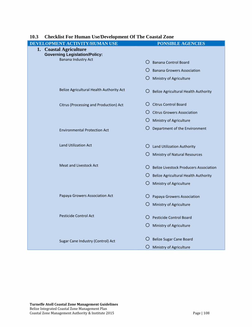
Turneffe Atoll Coastal Zone Management Guidelines Belize Integrated Coastal Zone Management Plan Coastal Zone Management Authority & Institute 2015 Page | 108
10.3 Checklist For Human Use/Development Of The Coastal Zone
DEVELOPMENT ACTIVITY/HUMAN USE RESPONSIBLE AGENCIES
1. Coastal Agriculture Governing Legislation/Policy:
Banana Industry Act Belize Agricultural Health Authority Act Citrus (Processing and Production) Act Environmental Protection Act Land Utilization Act Meat and Livestock Act Papaya Growers Association Act Pesticide Control Act Sugar Cane Industry (Control) Act
o Banana Control Board
o Banana Growers Association
o Ministry of Agriculture
o Belize Agricultural Health Authority
o Citrus Control Board
o Citrus Growers Association
o Ministry of Agriculture
o Department of the Environment
o Land Utilization Authority
o Ministry of Natural Resources
o Belize Livestock Producers Association
o Belize Agricultural Health Authority
o Ministry of Agriculture
o Papaya Growers Association
o Ministry of Agriculture
o Pesticide Control Board
o Ministry of Agriculture
o Belize Sugar Cane Board
o Ministry of Agriculture
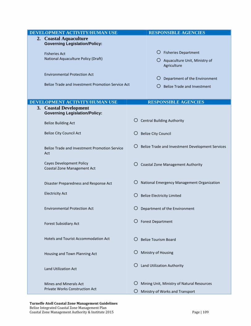
Turneffe Atoll Coastal Zone Management Guidelines Belize Integrated Coastal Zone Management Plan Coastal Zone Management Authority & Institute 2015 Page | 109
DEVELOPMENT ACTIVITY/HUMAN USE RESPONSIBLE AGENCIES
2. Coastal Aquaculture Governing Legislation/Policy:
Fisheries Act National Aquaculture Policy (Draft)
Environmental Protection Act Belize Trade and Investment Promotion Service Act
o Fisheries Department
o Aquaculture Unit, Ministry of Agriculture
o Department of the Environment
o Belize Trade and Investment
DEVELOPMENT ACTIVITY/HUMAN USE RESPONSIBLE AGENCIES
3. Coastal Development Governing Legislation/Policy:
Belize Building Act Belize City Council Act Belize Trade and Investment Promotion Service Act Cayes Development Policy Coastal Zone Management Act Disaster Preparedness and Response Act Electricity Act Environmental Protection Act Forest Subsidiary Act Hotels and Tourist Accommodation Act Housing and Town Planning Act Land Utilization Act Mines and Minerals Act Private Works Construction Act
o Central Building Authority
o Belize City Council
o Belize Trade and Investment Development Services
o Coastal Zone Management Authority
o National Emergency Management Organization
o Belize Electricity Limited
o Department of the Environment
o Forest Department
o Belize Tourism Board
o Ministry of Housing
o Land Utilization Authority
o Mining Unit, Ministry of Natural Resources
o Ministry of Works and Transport
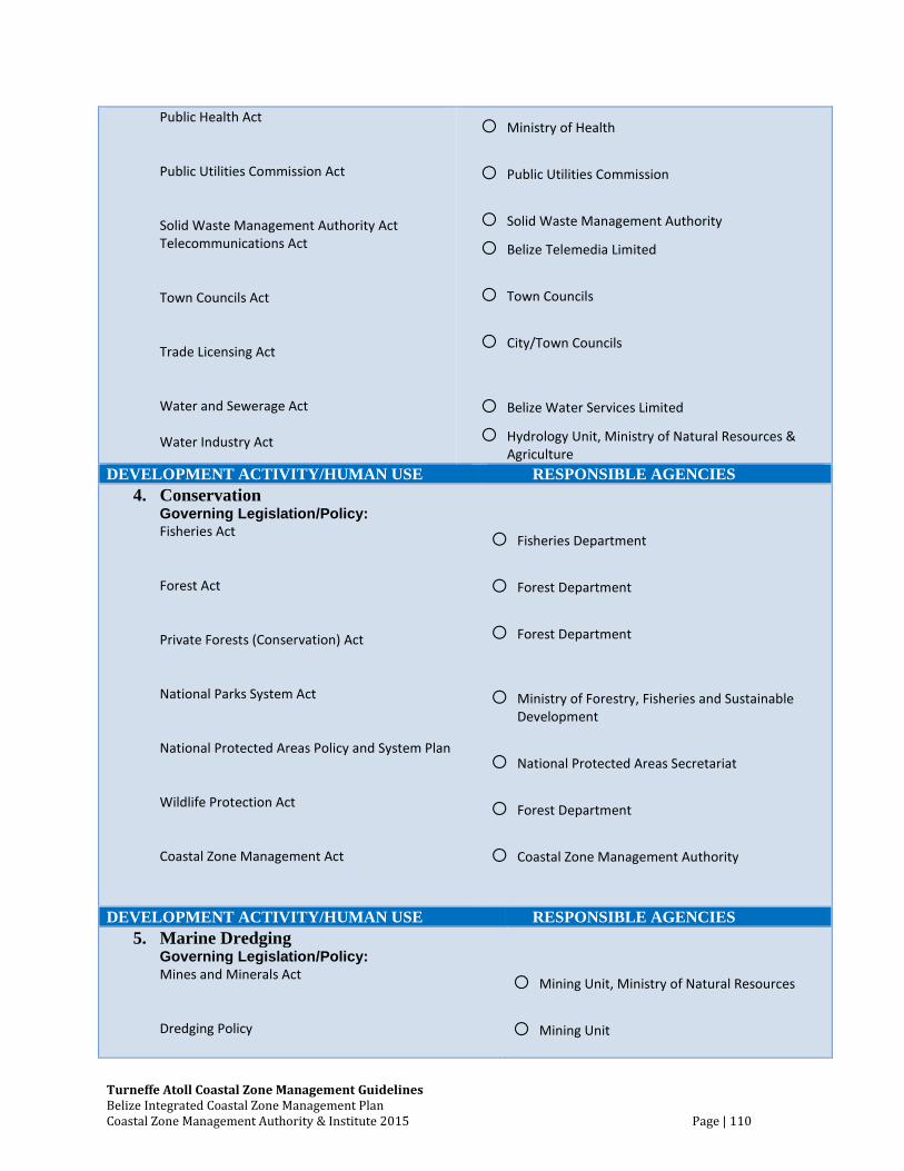
Turneffe Atoll Coastal Zone Management Guidelines Belize Integrated Coastal Zone Management Plan Coastal Zone Management Authority & Institute 2015 Page | 110
Public Health Act Public Utilities Commission Act Solid Waste Management Authority Act Telecommunications Act Town Councils Act Trade Licensing Act Water and Sewerage Act Water Industry Act
o Ministry of Health
o Public Utilities Commission
o Solid Waste Management Authority
o Belize Telemedia Limited
o Town Councils
o City/Town Councils
o Belize Water Services Limited
o Hydrology Unit, Ministry of Natural Resources & Agriculture
DEVELOPMENT ACTIVITY/HUMAN USE RESPONSIBLE AGENCIES
4. Conservation Governing Legislation/Policy:
Fisheries Act Forest Act Private Forests (Conservation) Act National Parks System Act National Protected Areas Policy and System Plan Wildlife Protection Act Coastal Zone Management Act
o Fisheries Department
o Forest Department
o Forest Department
o Ministry of Forestry, Fisheries and Sustainable Development
o National Protected Areas Secretariat
o Forest Department
o Coastal Zone Management Authority
DEVELOPMENT ACTIVITY/HUMAN USE RESPONSIBLE AGENCIES
5. Marine Dredging Governing Legislation/Policy:
Mines and Minerals Act Dredging Policy
o Mining Unit, Ministry of Natural Resources
o Mining Unit
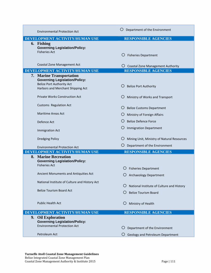
Turneffe Atoll Coastal Zone Management Guidelines Belize Integrated Coastal Zone Management Plan Coastal Zone Management Authority & Institute 2015 Page | 111
Environmental Protection Act o Department of the Environment
DEVELOPMENT ACTIVITY/HUMAN USE RESPONSIBLE AGENCIES
6. Fishing Governing Legislation/Policy:
Fisheries Act Coastal Zone Management Act
o Fisheries Department
o Coastal Zone Management Authority
DEVELOPMENT ACTIVITY/HUMAN USE RESPONSIBLE AGENCIES
7. Marine Transportation Governing Legislation/Policy:
Belize Port Authority Act Harbors and Merchant Shipping Act Private Works Construction Act Customs Regulation Act Maritime Areas Act Defence Act Immigration Act Dredging Policy Environmental Protection Act
o Belize Port Authority
o Ministry of Works and Transport
o Belize Customs Department
o Ministry of Foreign Affairs
o Belize Defence Force
o Immigration Department
o Mining Unit, Ministry of Natural Resources
o Department of the Environment
DEVELOPMENT ACTIVITY/HUMAN USE RESPONSIBLE AGENCIES
8. Marine Recreation Governing Legislation/Policy:
Fisheries Act Ancient Monuments and Antiquities Act National Institute of Culture and History Act Belize Tourism Board Act Public Health Act
o Fisheries Department
o Archaeology Department
o National Institute of Culture and History
o Belize Tourism Board
o Ministry of Health
DEVELOPMENT ACTIVITY/HUMAN USE RESPONSIBLE AGENCIES
9. Oil Exploration Governing Legislation/Policy:
Environmental Protection Act Petroleum Act
o Department of the Environment
o Geology and Petroleum Department

Turneffe Atoll Coastal Zone Management Guidelines Belize Integrated Coastal Zone Management Plan Coastal Zone Management Authority & Institute 2015 Page | 112
10.4 Figures
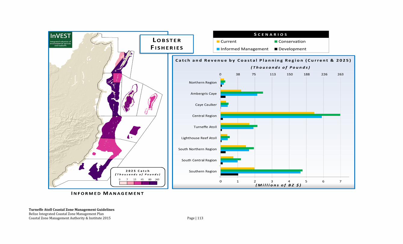
Turneffe Atoll Coastal Zone Management Guidelines Belize Integrated Coastal Zone Management Plan Coastal Zone Management Authority & Institute 2015 Page | 113
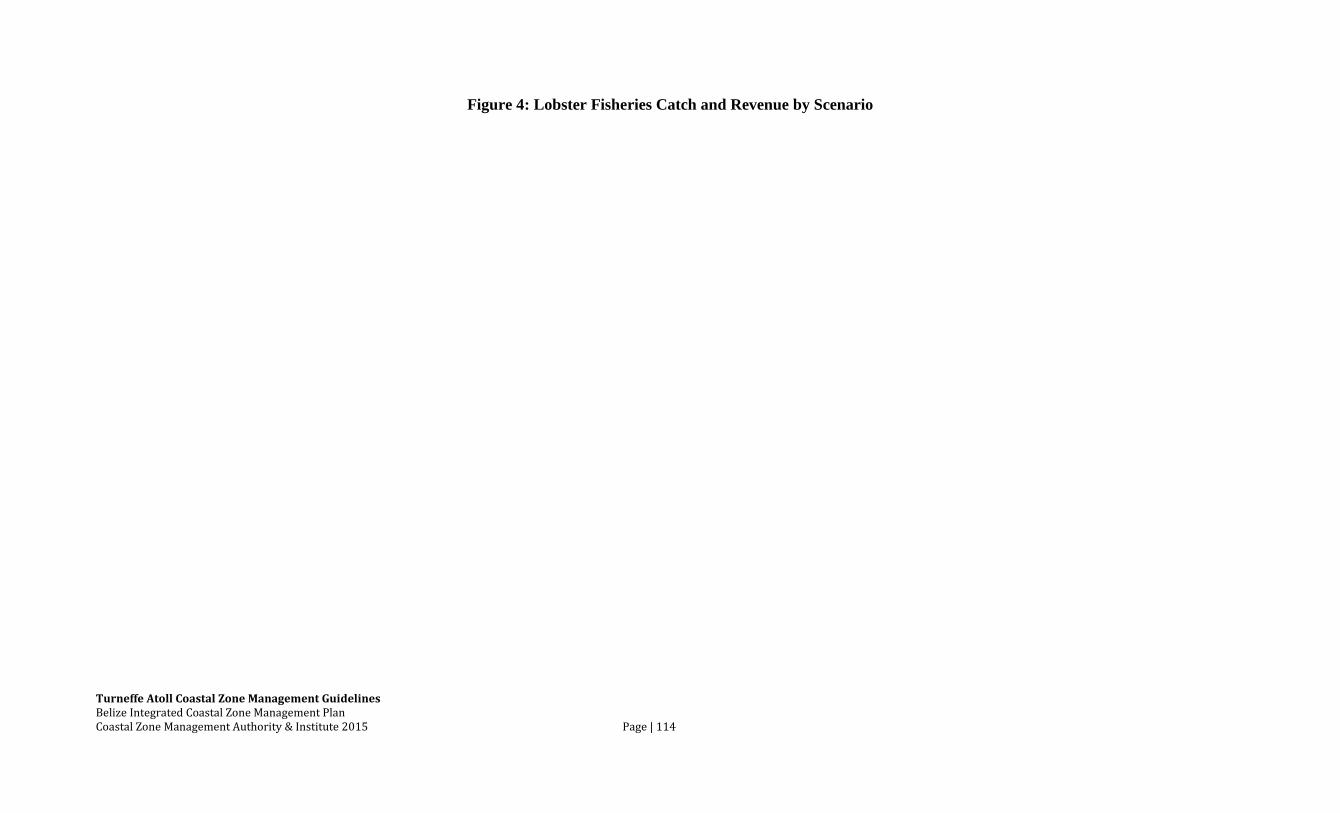
Turneffe Atoll Coastal Zone Management Guidelines Belize Integrated Coastal Zone Management Plan Coastal Zone Management Authority & Institute 2015 Page | 114
Figure 4: Lobster Fisheries Catch and Revenue by Scenario
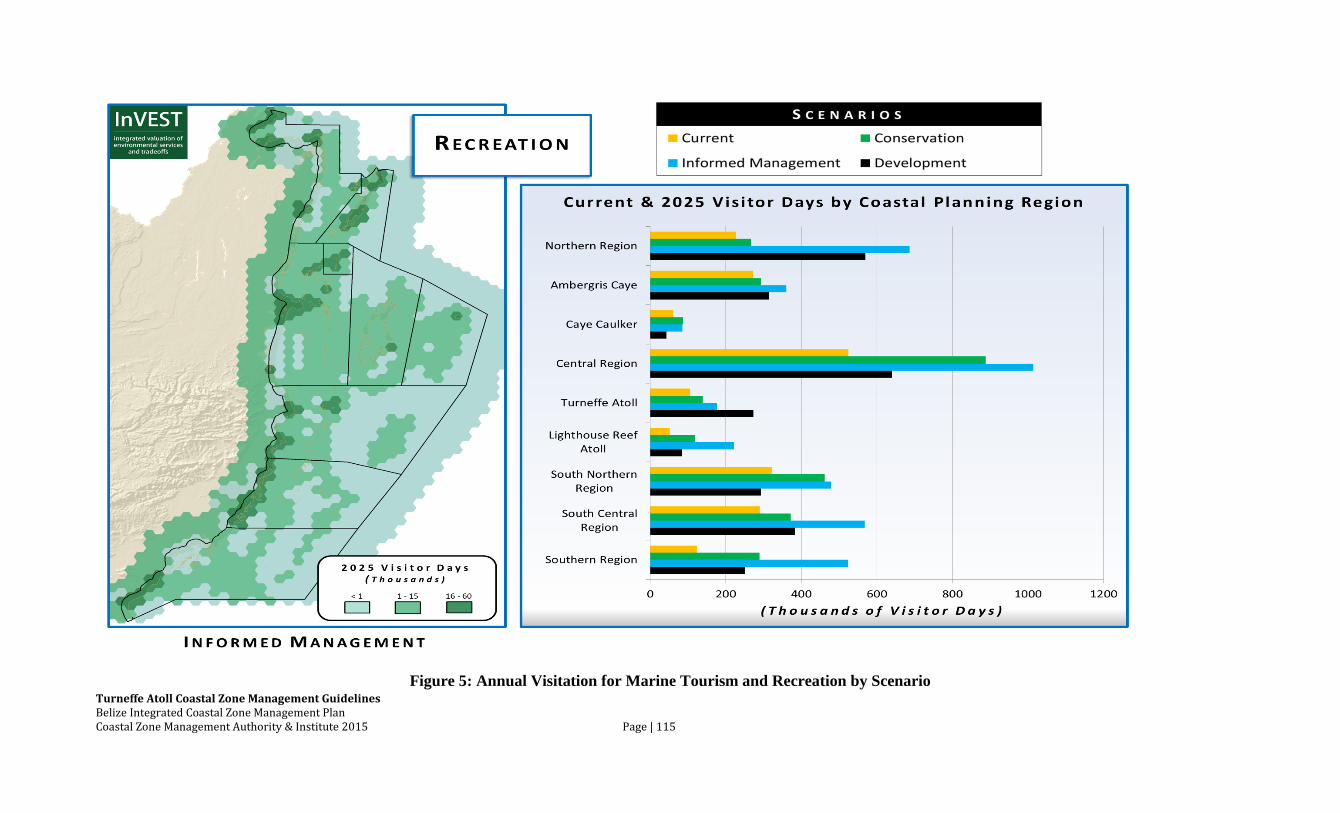
Turneffe Atoll Coastal Zone Management Guidelines Belize Integrated Coastal Zone Management Plan Coastal Zone Management Authority & Institute 2015 Page | 115
Figure 5: Annual Visitation for Marine Tourism and Recreation by Scenario

Turneffe Atoll Coastal Zone Management Guidelines Belize Integrated Coastal Zone Management Plan Coastal Zone Management Authority & Institute 2015 Page | 116
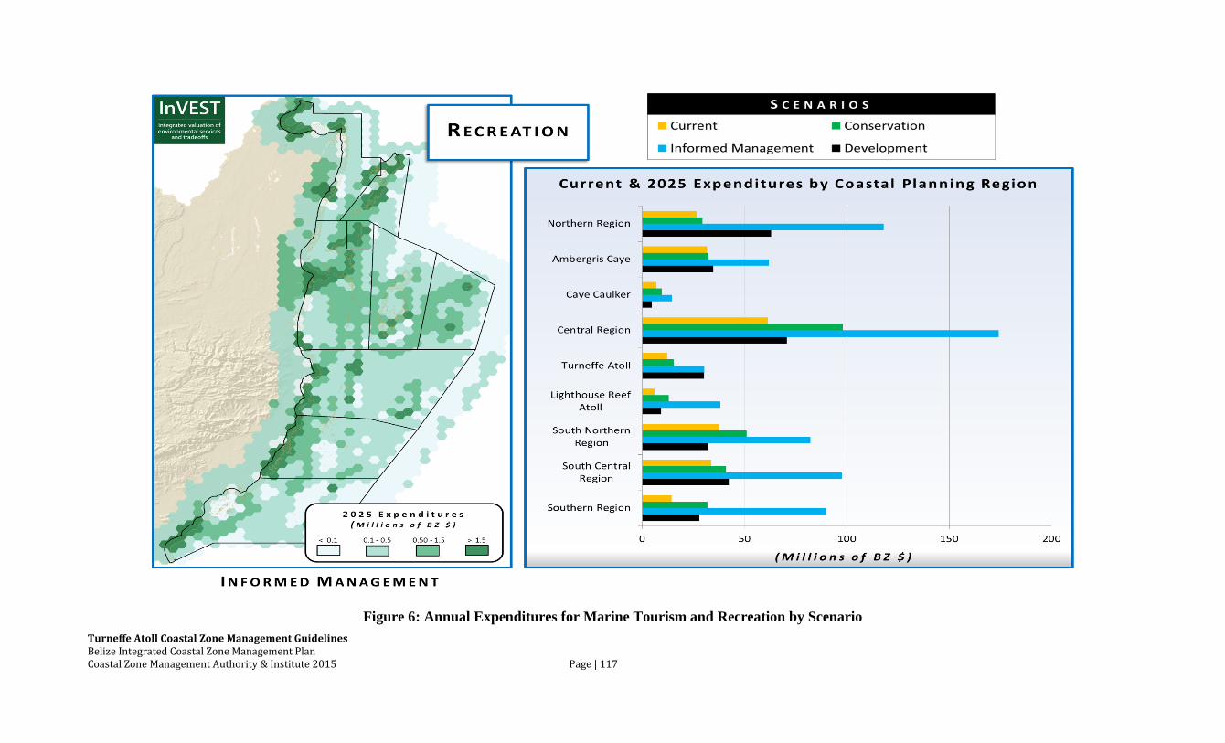
Turneffe Atoll Coastal Zone Management Guidelines Belize Integrated Coastal Zone Management Plan Coastal Zone Management Authority & Institute 2015 Page | 117
Figure 6: Annual Expenditures for Marine Tourism and Recreation by Scenario
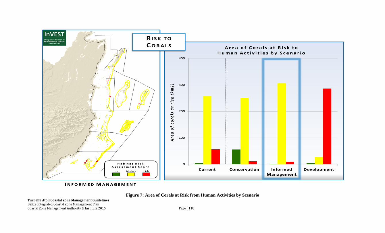
Turneffe Atoll Coastal Zone Management Guidelines Belize Integrated Coastal Zone Management Plan Coastal Zone Management Authority & Institute 2015 Page | 118
Figure 7: Area of Corals at Risk from Human Activities by Scenario
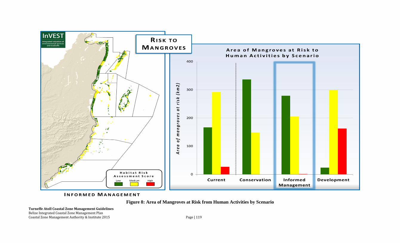
Turneffe Atoll Coastal Zone Management Guidelines Belize Integrated Coastal Zone Management Plan Coastal Zone Management Authority & Institute 2015 Page | 119
Figure 8: Area of Mangroves at Risk from Human Activities by Scenario
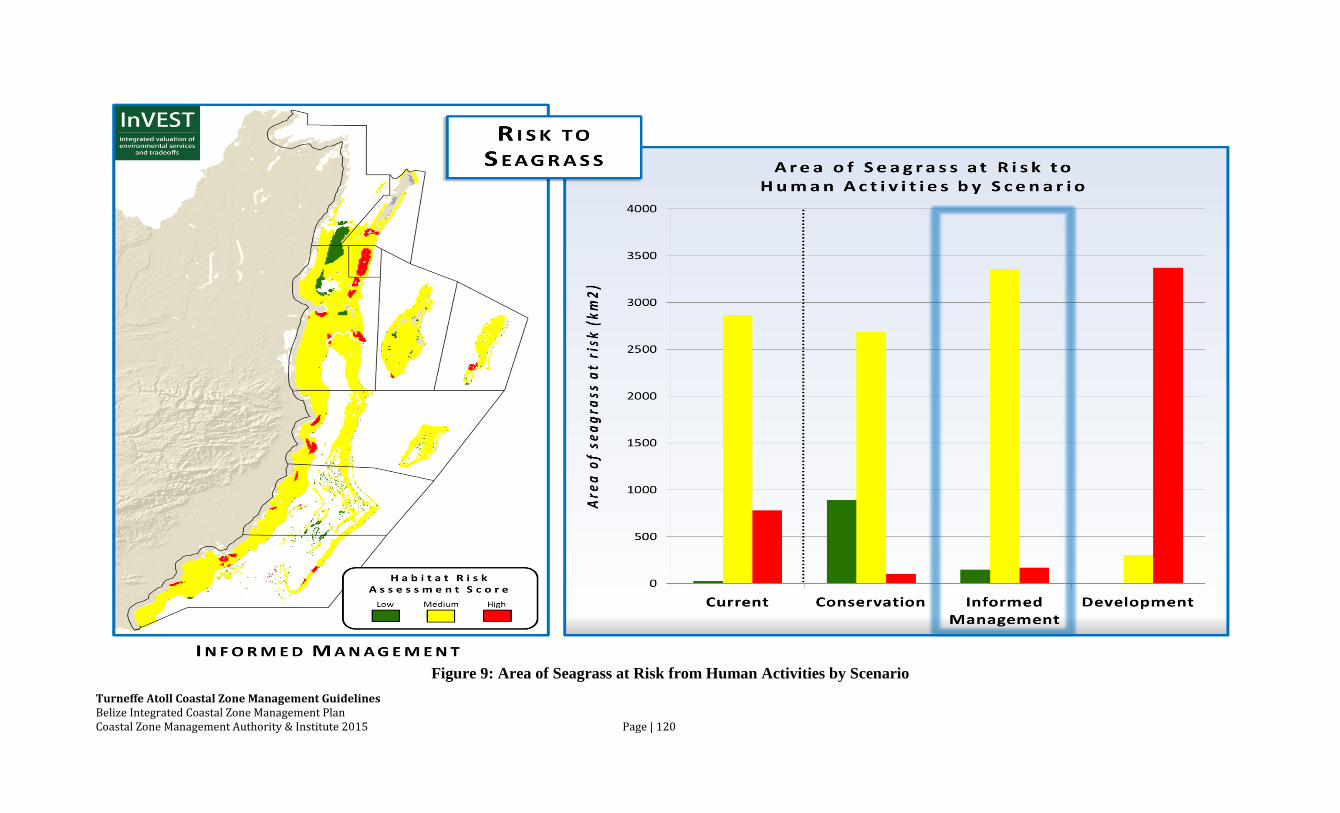
Turneffe Atoll Coastal Zone Management Guidelines Belize Integrated Coastal Zone Management Plan Coastal Zone Management Authority & Institute 2015 Page | 120
Figure 9: Area of Seagrass at Risk from Human Activities by Scenario