tsunami simulation for the great 1707 hoei, japan, earthquake … · 2015-07-29 · in the...
TRANSCRIPT

95
Chapter 1 Earth Science
1. IntroductionGreat inter-plate earthquakes have occurred at the Nankai
Trough at a recurrence interval of approximately 100 to 150 years due to the subduction of the Philippine Sea plate beneath southwestern Japan (Fig.1).
In the recorded history of the Nankai Trough earthquakes the 1707 Hoei earthquake (hereafter called the Hoei earthquake) was the largest shock in modern Japanese history. It killed more than 20,000 people due to its strong ground motion and the tsunami associated with the earthquake. The fault rupture area of the Hoei earthquake has been thought to spread from Suruga Bay to the westernmost end of Shikoku, which is often referred as a worst-case scenario for the Nankai Trough earthquake.
The source rupture histories of the recent 1944 Tonankai and 1946 Nankai earthquakes were examined extensively based on the analysis of modern instrumental data, such as tide gauge records of tsunami waveforms, seismograms, and geodetic data. However, the source model of the historical Hoei earthquake in 1707, on the other hand, have mostly been deduced from descriptions of earthquake phenomenon in ancient documents such as shaking felt by humans, damage to houses, and visual
measurements of tsunami inundation or tsunami run-up height, and pattern of ground elevation and subsidences.
Recently, geological surveys of earthquake-related lacustrine sediment in seashore lakes along the Pacific coast from Shikoku to Kyushu endeavor to clarify the tsunami history of the historical and pre-historical Nankai Trough earthquakes. Ryujin Lake is one such onshore lake that has tsunami-induced oceanic deposits (hereafter called tsunami lakes), located along the coast of the Hyuga-nada in Kyushu. Ryujin Lake has a thick cover of marine deposits, including coarse-grained sea sands and marine sediments containing oceanic plankton carried by Nankai Trough earthquake, not every 100 to 150 years, but were only deposited in the 1707 Hoei earthquake, the 1361 Shohei earthquake, and the 684 Tenmu earthquakes, probably associated with larger tsunamis than usual. Also, recent findings in the historical documents claim that the height of the tsunami during the Hoei earthquake at the village of Yonouzu, near Ryujin Lake, was more than 10 m, which is very much larger than regular tsunamis associated with the earthquake.
The data from the Japanese GEONET nation-wide GPS network illustrating the current ground deformation pattern of
Tsunami Simulation for the Great 1707 Hoei, Japan, Earthquake using the Earth Simulator
Project Representative
Takashi Furumura Center for Integrated Disaster Information Research, Interfaculty Initiative in Information Studies, The University of Tokyo / Earthquake Research Institute, The University of Tokyo
Authors
Takashi Furumura
Kentaro ImaiTakuto Maeda
Center for Integrated Disaster Information Research, Interfaculty Initiative in Information
Studies, The University of Tokyo / Earthquake Research Institute, The University of Tokyo
Tsunami Engineering Laboratory, Disaster Control Research Center, Tohoku University
Center for Integrated Disaster Information Research, Interfaculty Initiative in Information
Studies, The University of Tokyo / Earthquake Research Institute, The University of Tokyo
The source rupture area of the 1707 Hoei earthquake which occurred along the Nankai Trough, off southwestern Japan, should be extend further, to the Hyuga-nada, more than 70 km beyond the currently accepted location at the westernmost end of Shikoku in order to explain many recent findings such as those for geodetic data and geological investigations in coastal area and large tsunami in Kyushu, Japan. Numerical simulation of the tsunami using a new source-rupture model for the Hoei earthquake explains the distribution of the very high tsunami observed along the Pacific coast from western Shikoku to Kyushu more consistently with tsunami run-up into Ryujin Lake at Kyushu. It is known that the tsunamis from the 684 Tenmu, 1361 Shokei, and 1707 Hoei earthquakes deposited sand in Ryujin Lake, but lesser tsunamis from other earthquakes were unable to reach the lake. This irregular behavior suggests that, in addition to the regular Nankai Trough earthquake cycle of 100-150 years, there may be a hyper-earthquake cycle of 300-500 years. These greater earthquakes produce the larger tsunamis from western Shikoku to Kyushu than we expect for future Nankai Trough earthquake.
Keywords: Earthquake, 1707 Hoei earthquake, Hyuga-nada, Source-rupture model, Tsunami
96
Annual Report of the Earth Simulator Center April 2010 - March 2011
undergoing recovery process of post- Nankai Trough earthquake and studies on inter-plate coupling along the Nankai Trough using this data reveal strong interplate coupling along the Nankai Trough extends to Hyuga-nada.
Following these new findings and supporting instrumental data, we will reexamine the source model for the Hoei earthquake and extended the source-rupture area 70 km eastward to the Hyuga-nada from the westernmost end of Shikoku.
We will demonstrated by tsunami simulation that our new source Hoei earthquake source model can explain large tsunami observed in Kyushu and tsunami inundation into Ryujin Lake more consistently than previous models.
2. Tsunami Simulation for the 1707 Hoei EarthquakeWe first conducted tsunami simulation for the Hoei
earthquake using a source model of An'naka et al. (2003) [1] which consists of four fault segments (N1 to N4) extending from Suruga Bay to the westernmost end of Shikoku, a total length of 605 km.
Vertical ground deformation due to fault rupture of the N1 through N4 fault segments are calculated using the program following Mansinha and Smylie (1975) [2]. The result shows large ground upheavals of up to 2 m above the shallowest end of the source fault segment on the trench side and some of
upheaval can be found on land, including at Cape Muroto, Cape Shiono, and along the coast of Suruga Bay. On the other hand, large surface subsidence of as much as 2 m is found widely on land in a narrow belt zone extending from Shizuoka to the westernmost end of Shikoku. These are consistent with the observed ground deformation pattern of the Hoei earthquake.
Using the results of the coseismic ground deformation pattern, we conducted a tsunami simulation. The area of the simulation is 540 km by 860 km which has been discritized by a nested mesh model that connects gradually 30 m, 90 m, and 270 m mesh model to allow efficient simulation of the tsunami in heterogeneous bathymetry. The bathymetric model was provided by the Central Disaster Mitigation Council, Cabinet Office, Government of Japan. Then propagation of the tsunami and tsunami run-up are calculated based on a finite-difference method (FDM) of a nonlinear, long-wave tsunami model (Goto and Ogawa, 1997) [3].
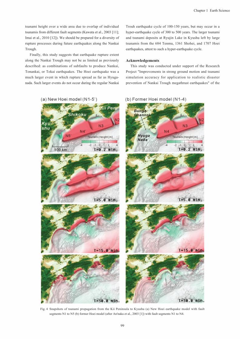
Snapshots of tsunami propagation obtained from the simulation are illustrated in fig. 2 at time T = 1, 5, 10, 20, 40, and 80 min from the time the earthquake started. The snapshots shows that the radiation of tsunamis from rectangular fault sources is very strong in the direction perpendicular to the trough axis, while it is very weak in the direction parallel to the trough. As the tsunami approaches the shore, its speed decreases suddenly and its height increases very drastically. The onshore height of the tsunami, more than 8 m, is several times larger than the height of the initial tsunami above the source area along the Pacific coast from the westernmost end of Shikoku to Hyuga-nada. The tsunami lasts for several tens of minutes after the earthquake and a number of tsunami trains are captured within Tosa Bay.
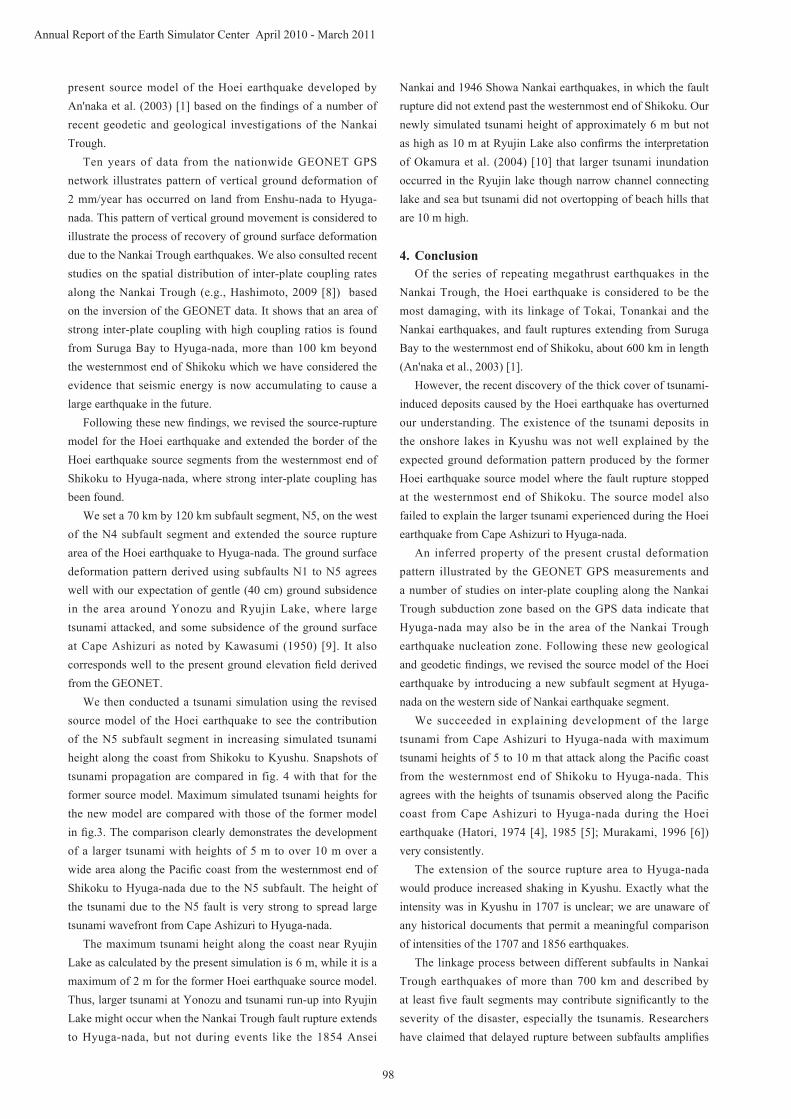
Distribution of maximum simulated tsunami height is illustrated in fig. 3. From historical records, tsunami heights of 9 m at Tosa Shimizu and Ashizuri Cape and more than 4 m along the coast from Ashizuri Cape to Hyuga-nada are known to have occurred. The simulated maximum tsunami height along the Pacific coast from Tosa Bay to Suruga Bay generally agrees well with observed tsunami run-up during the Hoei earthquake (e.g., Hatori, 1974 [4], 1985 [5]; Murakami et al., 1996 [6]). However, the height of the simulated tsunami from western Shikoku to Hyuga-nada in Kyushu is less than half of the actual height observed. For example, historical archives document that at Yonouzu village, at the northern end of Hyuga-nada, the tsunami was more than 10 m and killed 18 people (Chida et al, 2003) [7]. Yet the simulated tsunami height at Yonouzu is less than 4 m, much shorter than the tsunami experienced with the Hoei earthquake.
3. Revision of the Source Model for the 1707 Hoei earthquakeIn order to better explain the height of the Hoei earthquake
tsunami from Cape Ashizuri to Hyuga-nada, we revised the
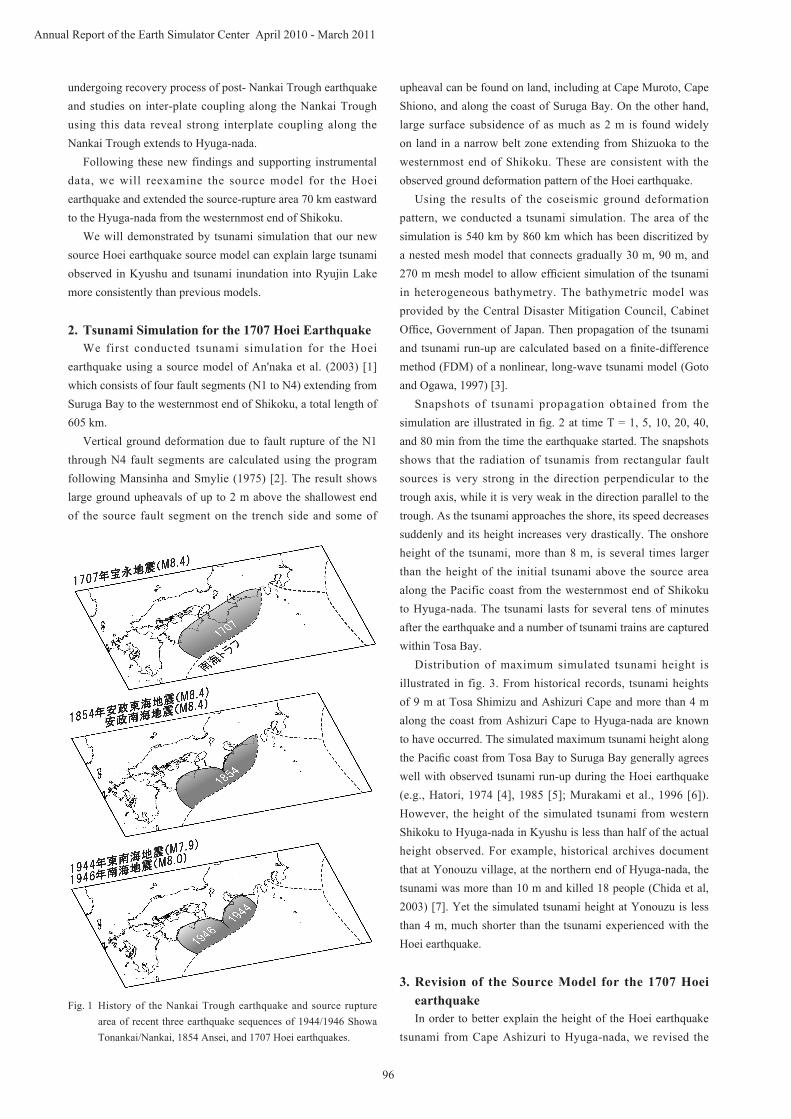
Fig. 1 History of the Nankai Trough earthquake and source rupture area of recent three earthquake sequences of 1944/1946 Showa Tonankai/Nankai, 1854 Ansei, and 1707 Hoei earthquakes.

97
Chapter 1 Earth Science
Fig. 2 Snapshots of the tsunami propagation for the 1707 Hoei earthquake at T = 1.0, 5.0, 10.0, 20.0, 40.0, and 80.0 min. Red and blue colors indicate uplift and subsidence of the sea surface, respectively.
Fig. 3 Maximum height of tsunami derive by the tsunami simulation for the former Hoei earthquake source model (black) and new source model (red) comparing with observation (circles).
98
Annual Report of the Earth Simulator Center April 2010 - March 2011
present source model of the Hoei earthquake developed by An'naka et al. (2003) [1] based on the findings of a number of recent geodetic and geological investigations of the Nankai Trough.
Ten years of data from the nationwide GEONET GPS network illustrates pattern of vertical ground deformation of 2 mm/year has occurred on land from Enshu-nada to Hyuga-nada. This pattern of vertical ground movement is considered to illustrate the process of recovery of ground surface deformation due to the Nankai Trough earthquakes. We also consulted recent studies on the spatial distribution of inter-plate coupling rates along the Nankai Trough (e.g., Hashimoto, 2009 [8]) based on the inversion of the GEONET data. It shows that an area of strong inter-plate coupling with high coupling ratios is found from Suruga Bay to Hyuga-nada, more than 100 km beyond the westernmost end of Shikoku which we have considered the evidence that seismic energy is now accumulating to cause a large earthquake in the future.
Following these new findings, we revised the source-rupture model for the Hoei earthquake and extended the border of the Hoei earthquake source segments from the westernmost end of Shikoku to Hyuga-nada, where strong inter-plate coupling has been found.
We set a 70 km by 120 km subfault segment, N5, on the west of the N4 subfault segment and extended the source rupture area of the Hoei earthquake to Hyuga-nada. The ground surface deformation pattern derived using subfaults N1 to N5 agrees well with our expectation of gentle (40 cm) ground subsidence in the area around Yonozu and Ryujin Lake, where large tsunami attacked, and some subsidence of the ground surface at Cape Ashizuri as noted by Kawasumi (1950) [9]. It also corresponds well to the present ground elevation field derived from the GEONET.
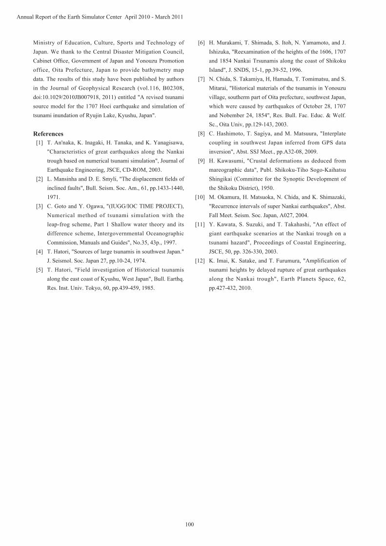
We then conducted a tsunami simulation using the revised source model of the Hoei earthquake to see the contribution of the N5 subfault segment in increasing simulated tsunami height along the coast from Shikoku to Kyushu. Snapshots of tsunami propagation are compared in fig. 4 with that for the former source model. Maximum simulated tsunami heights for the new model are compared with those of the former model in fig.3. The comparison clearly demonstrates the development of a larger tsunami with heights of 5 m to over 10 m over a wide area along the Pacific coast from the westernmost end of Shikoku to Hyuga-nada due to the N5 subfault. The height of the tsunami due to the N5 fault is very strong to spread large tsunami wavefront from Cape Ashizuri to Hyuga-nada.
The maximum tsunami height along the coast near Ryujin Lake as calculated by the present simulation is 6 m, while it is a maximum of 2 m for the former Hoei earthquake source model. Thus, larger tsunami at Yonozu and tsunami run-up into Ryujin Lake might occur when the Nankai Trough fault rupture extends to Hyuga-nada, but not during events like the 1854 Ansei
Nankai and 1946 Showa Nankai earthquakes, in which the fault rupture did not extend past the westernmost end of Shikoku. Our newly simulated tsunami height of approximately 6 m but not as high as 10 m at Ryujin Lake also confirms the interpretation of Okamura et al. (2004) [10] that larger tsunami inundation occurred in the Ryujin lake though narrow channel connecting lake and sea but tsunami did not overtopping of beach hills that are 10 m high.
4. ConclusionOf the series of repeating megathrust earthquakes in the
Nankai Trough, the Hoei earthquake is considered to be the most damaging, with its linkage of Tokai, Tonankai and the Nankai earthquakes, and fault ruptures extending from Suruga Bay to the westernmost end of Shikoku, about 600 km in length (An'naka et al., 2003) [1].
However, the recent discovery of the thick cover of tsunami-induced deposits caused by the Hoei earthquake has overturned our understanding. The existence of the tsunami deposits in the onshore lakes in Kyushu was not well explained by the expected ground deformation pattern produced by the former Hoei earthquake source model where the fault rupture stopped at the westernmost end of Shikoku. The source model also failed to explain the larger tsunami experienced during the Hoei earthquake from Cape Ashizuri to Hyuga-nada.
An inferred property of the present crustal deformation pattern illustrated by the GEONET GPS measurements and a number of studies on inter-plate coupling along the Nankai Trough subduction zone based on the GPS data indicate that Hyuga-nada may also be in the area of the Nankai Trough earthquake nucleation zone. Following these new geological and geodetic findings, we revised the source model of the Hoei earthquake by introducing a new subfault segment at Hyuga-nada on the western side of Nankai earthquake segment.
We succeeded in explaining development of the large tsunami from Cape Ashizuri to Hyuga-nada with maximum tsunami heights of 5 to 10 m that attack along the Pacific coast from the westernmost end of Shikoku to Hyuga-nada. This agrees with the heights of tsunamis observed along the Pacific coast from Cape Ashizuri to Hyuga-nada during the Hoei earthquake (Hatori, 1974 [4], 1985 [5]; Murakami, 1996 [6]) very consistently.
The extension of the source rupture area to Hyuga-nada would produce increased shaking in Kyushu. Exactly what the intensity was in Kyushu in 1707 is unclear; we are unaware of any historical documents that permit a meaningful comparison of intensities of the 1707 and 1856 earthquakes.
The linkage process between different subfaults in Nankai Trough earthquakes of more than 700 km and described by at least five fault segments may contribute significantly to the severity of the disaster, especially the tsunamis. Researchers have claimed that delayed rupture between subfaults amplifies
99
Chapter 1 Earth Science
tsunami height over a wide area due to overlap of individual tsunamis from different fault segments (Kawata et al., 2003 [11]; Imai et al., 2010 [12]). We should be prepared for a diversity of rupture processes during future earthquakes along the Nankai Trough.
Finally, this study suggests that earthquake rupture extent along the Nankai Trough may not be as limited as previously described: as combinations of subfaults to produce Nankai, Tonankai, or Tokai earthquakes. The Hoei earthquake was a much larger event in which rupture spread as far as Hyuga-nada. Such larger events do not occur during the regular Nankai
Trouh earthquake cycle of 100-150 years, but may occur in a hyper-earthquake cycle of 300 to 500 years. The larger tsunami and tsunami deposits at Ryujin Lake in Kyushu left by large tsunamis from the 684 Tenmu, 1361 Shohei, and 1707 Hoei earthquakes, attest to such a hyper-earthquake cycle.
AcknowledgementsThis study was conducted under support of the Research
Project "Improvements in strong ground motion and tsunami simulation accuracy for application to realistic disaster prevention of Nankai Trough megathrust earthquakes" of the
Fig. 4 Snapshots of tsunami propagation from the Kii Peninsula to Kyushu (a) New Hoei earthquake model with fault segments N1 to N5 (b) former Hoei model (after An'naka et al., 2003 [1]) with fault segments N1 to N4.
100
Annual Report of the Earth Simulator Center April 2010 - March 2011
Ministry of Education, Culture, Sports and Technology of Japan. We thank to the Central Disaster Mitigation Council, Cabinet Office, Government of Japan and Yonouzu Promotion office, Oita Prefecture, Japan to provide bathymetry map data. The results of this study have been published by authors in the Journal of Geophysical Research (vol.116, B02308, doi:10.1029/2010JB007918, 2011) entitled "A revised tsunami source model for the 1707 Hoei earthquake and simulation of tsunami inundation of Ryujin Lake, Kyushu, Japan".
References[1] T. An'naka, K. Inagaki, H. Tanaka, and K. Yanagisawa,
"Characteristics of great earthquakes along the Nankai trough based on numerical tsunami simulation", Journal of Earthquake Engineering, JSCE, CD-ROM, 2003.
[2] L. Mansinha and D. E. Smyli, "The displacement fields of inclined faults", Bull. Seism. Soc. Am., 61, pp.1433-1440, 1971.
[3] C. Goto and Y. Ogawa, "(IUGG/IOC TIME PROJECT), Numerical method of tsunami simulation with the leap-frog scheme, Part 1 Shallow water theory and its difference scheme, Intergovernmental Oceanographic Commission, Manuals and Guides", No.35, 43p., 1997.
[4] T. Hatori, "Sources of large tsunamis in southwest Japan." J. Seismol. Soc. Japan 27, pp.10-24, 1974.
[5] T. Hatori, "Field investigation of Historical tsunamis along the east coast of Kyushu, West Japan", Bull. Earthq. Res. Inst. Univ. Tokyo, 60, pp.439-459, 1985.
[6] H. Murakami, T. Shimada, S. Itoh, N. Yamamoto, and J. Ishizuka, "Reexamination of the heights of the 1606, 1707 and 1854 Nankai Trsunamis along the coast of Shikoku Island", J. SNDS, 15-1, pp.39-52, 1996.
[7] N. Chida, S. Takamiya, H, Hamada, T. Tomimatsu, and S. Mitarai, "Historical materials of the tsunamis in Yonouzu village, southerm part of Oita prefecture, southwest Japan, which were caused by earthquakes of October 28, 1707 and Nobember 24, 1854", Res. Bull. Fac. Educ. & Welf. Sc., Oita Univ, pp.129-143, 2003.
[8] C. Hashimoto, T. Sagiya, and M. Matsuura, "Interplate coupling in southwest Japan inferred from GPS data inversion", Abst. SSJ Meet., pp.A32-08, 2009.
[9] H. Kawasumi, "Crustal deformations as deduced from mareographic data", Publ. Shikoku-Tiho Sogo-Kaihatsu Shingikai (Committee for the Synoptic Development of the Shikoku District), 1950.
[10] M. Okamura, H. Matsuoka, N. Chida, and K. Shimazaki, "Recurrence intervals of super Nankai earthquakes", Abst. Fall Meet. Seism. Soc. Japan, A027, 2004.
[11] Y. Kawata, S. Suzuki, and T. Takahashi, "An effect of giant earthquake scenarios at the Nankai trough on a tsunami hazard", Proceedings of Coastal Engineering, JSCE, 50, pp. 326-330, 2003.
[12] K. Imai, K. Satake, and T. Furumura, "Amplification of tsunami heights by delayed rupture of great earthquakes along the Nankai trough", Earth Planets Space, 62, pp.427-432, 2010.
101
Chapter 1 Earth Science
地球シミュレータによる 1707 年宝永地震の津波シミュレーション
プロジェクト責任者
古村 孝志 東京大学 大学院情報学環総合防災情報研究センター
東京大学 地震研究所
著者古村 孝志 東京大学 大学院情報学環総合防災情報研究センター 東京大学 地震研究所今井健太郎 東北大学 大学院工学研究科附属災害制御研究センター前田 拓人 東京大学 大学院情報学環総合防災情報研究センター 東京大学 地震研究所
近年の地震研究から、南海トラフで発生した 1707年宝永地震の震源域は、これまで想定していた足摺岬までではなく日向灘にかけてさらに 70 km以上延びていた可能性が高くなってきた。このことを受けて、地球シミュレータを用いて宝永地震の新しい震源モデルを用いた津波と強震動シミュレーションを実施した。特に、宝永地震時に大分県佐伯町の龍神池で津波堆積物が保存されていることに着目し、新しい震源モデルによる津波を評価して、さらに津波の浸水シミュレーションを行ってモデルの確かさを検証した。これにより、南海トラフでは 100-150年周期で規則的に大地震が起きているだけでなく、宝永地震のように東海・東南海・南海地震が 3連動発生して震源域が拡大し、四国~九州の津波が高くなる現象が 300-500年に一度起きていたことが明らかとなり、将来の南海トラフ地震による強震動と津波の予測を行う上で新たな課題が提示された。
キーワード : 地震 , 津波 , 1707年宝永地震 , 南海トラフ