tsunami advisory information for the northwest pacific and indian oceans issued by the japan...
TRANSCRIPT
Tsunami Advisory Information for the Northwest Pacific and Indian Oceans issued by the
Japan Meteorological Agency
Yuji NISHIMAE
Japan Meteorological Agency

Contents
• JMA Tsunami Warning Service
• Techniques for determination of hypocenter and magnitude of distant earthquakes
• Northwest Pacific Tsunami Advisory
• Tsunami Watch Information for the Indian Ocean
• Summary

JMA
Pacific Tsunami Warning Center/NOAA
Exchange of Information ・ Hypocenter ・Magnitude ・ Tsunami Observation
Seismological Data
Sea Level Data
Tsunami Warning to
Japan
Northwest Pacific
Tsunami Advisory
Tsunami Watch Information to
the Indian Ocean Countries
JMA Tsunami Warning Service

Occurrence of
Earthquake GenerationGeneration
ofofTsunamiTsunami
Detection of
Seismic Wave
Determinationof
Location and Magnitude
Evaluationof
Expected Tsunami
Issuanceof
Tsunami Warning
Updateof
Tsunami Information
Detection of
Tsunami at sea level station
Seismic Network Seismic Network
Real time data processing systemReal time data processing system
Components of tsunami warning system
Sea Level Data to monitor tsunami Sea Level Data to monitor tsunami
Sequence of Tsunami Warning
Real time data transmission Real time data transmission
Re-evaluationof
Tsunami
(Propagation)

Techniques for determination of hypocenter and magnitude of
distant earthquakes

Global Seismological Network (IRIS/USGS, IRIS/IDA)
Worldwide Network (Broadband Stations)
IRIS/USGS seismic data via the Internet.
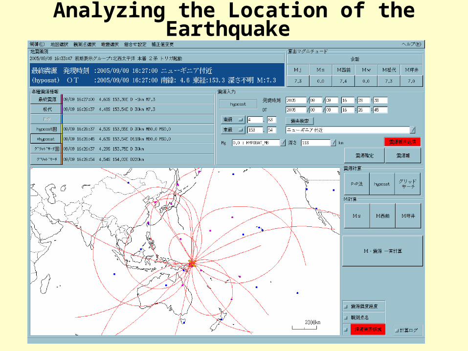
Analyzing the Location of the Earthquake
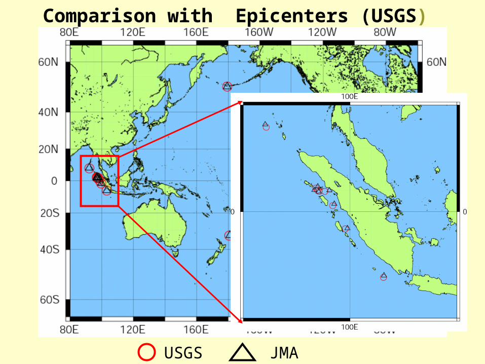
Comparison with Epicenters (USGS)
USGS JMA

Calculation of Mwp
Seismic wave form of UD component of STS2 seismometer
10-3 10-2 10-1 100 1010
0.2
0.4
0.6
0.8
1
1.2
1.4
Frequency(Hz)
Mag
nific
atio
n
Frequency response of the filter applied to the seismic wave data
S
S
P
P
Mw=a*log(A)+b*sin(Δ /2)+cMw : moment magnitudeA : root mean square amplitude of UD component of STS2Δ : epicentral distance in degree

Empirical formula for Mwp
5 5.5 6 6.5 7 7.5 8 8.55
5.5
6
6.5
7
7.5
8
8.5
Mw(Harvard)M
w(M
at)
5 5.5 6 6.5 7 7.5 8 8.55
5.5
6
6.5
7
7.5
8
8.5
Mw(Harvard)
Mw(M
at)
3minutes P-S
Mw : moment magnitudeA : root mean square amplitude of UD component of STS2Δ : epicentral distance in degree
Mw=0.82027log(A)+1.04289log(sin(Δ /2))+5.62775 Mw=0.83419og(A)+0.98455log(sin(Δ /2))+5.63274

Comparison with Mw(Harvard)
5.5
6.0
6.5
7.0
7.5
8.0
8.5
5.5 6.0 6.5 7.0 7.5 8.0 8.5Mw (Harvard)
Mw
p (
JMA
)
8m以上
8m 2m~4m 2m~2m 1m~1m以下
8m以上
8m 2m~4m 2m~2m 1m~1m以下
8m以上
8m 2m~4m 2m~2m 1m~1m以下
データベース
Major TsunamiTsunamiTsunami Attention
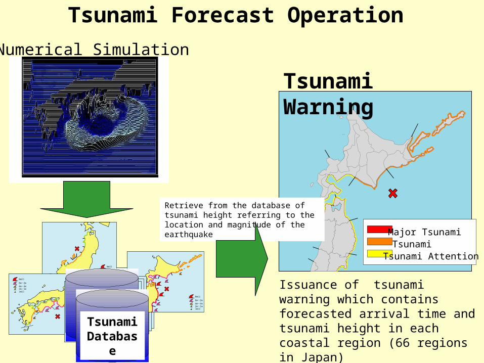
Tsunami Forecast Operation
量的津波データベース
量的津波データベース
Issuance of tsunami warning which contains forecasted arrival time and tsunami height in each coastal region (66 regions in Japan)Tsunami
Database
Tsunami Warning
Retrieve from the database of tsunami height referring to the location and magnitude of the earthquake
Numerical Simulation

Setting Fault Models
Assumed Epicenter:Assumed Epicenter:
4141
MagnitudeMagnitude ::
7.0, 7.5, 8.0, 8.57.0, 7.5, 8.0, 8.5
Depth:
0, 20, 40,60,80,100km

CMT analysis
• Length of Data– 20 minutes
– 30 minutes
0 20 40 60 80 100 120 140 160 180-4000
-2000
0
2000
4000YAK
0 20 40 60 80 100 120 140 160 180-4000
-2000
0
2000
4000YAK
0 20 40 60 80 100 120 140 160 180-6000
-4000
-2000
0
2000
4000
6000 YAK
0 50 100 150 200 250 300 350-4000
-2000
0
2000
4000ULN
0 50 100 150 200 250 300 350-3000
-2000
-1000
0
1000
2000
3000
ULN
0 50 100 150 200 250 300 350-3000
-2000
-1000
0
1000
2000
3000
ULN
YAK ULN
0 50 100 150 200 250 300-600
-400
-200
0
200
400
KONO
0 50 100 150 200 250 300-2000
-1000
0
1000
2000KONO
0 50 100 150 200 250 300-500
0
500
1000
1500KONO
KONO
0 50 100 150 200 250 300 350-1500
-1000
-500
0
500
1000
1500
MA2
0 50 100 150 200 250 300 350-2000
-1000
0
1000
2000
3000
MA2
0 50 100 150 200 250 300 350-6000
-4000
-2000
0
2000
4000
MA2
MA2
Comparison between synthetic waves(red) and observed waves(blue). Radial, transverse and vertical component from top and bottom in each station.
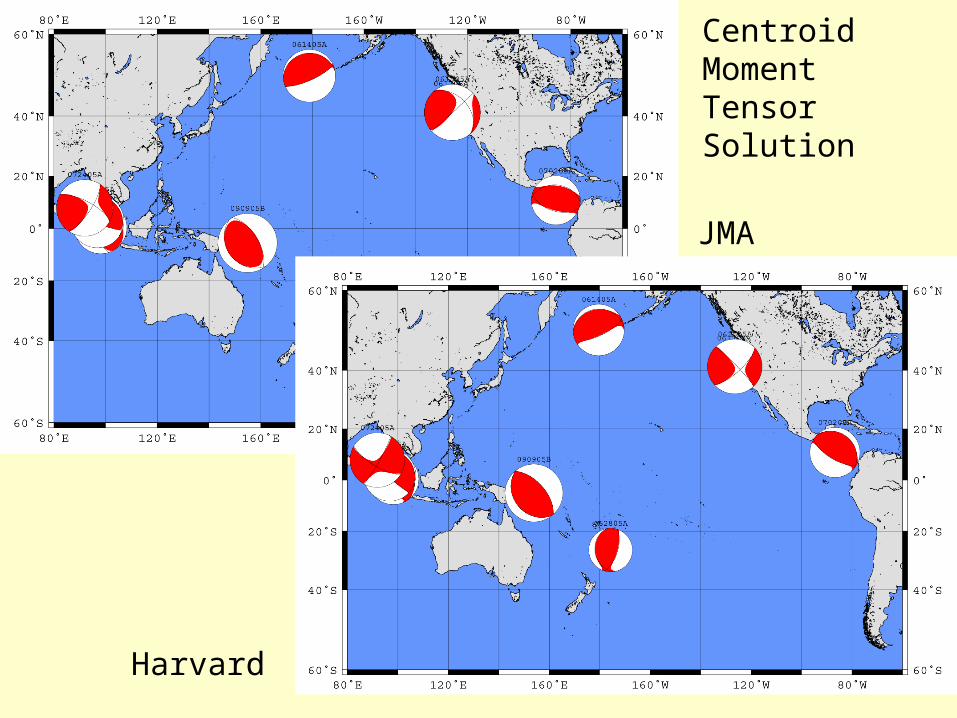
JMA
Harvard
Centroid Moment Tensor Solution
Northwest Pacific Tsunami Advisory
GlobalSeismicNetwork
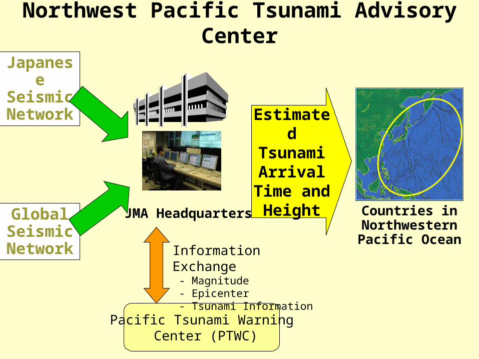
Northwest Pacific Tsunami Advisory Center
Estimated Tsunami Arrival
Time and Height
Countries in Northwestern Pacific Ocean
JMA Headquarters
JapaneseSeismicNetwork
Pacific Tsunami Warning Center (PTWC)
Information Exchange - Magnitude - Epicenter - Tsunami Information
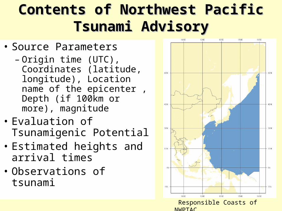
Contents of Northwest Pacific Tsunami Contents of Northwest Pacific Tsunami AdvisoryAdvisory
Responsible Coasts of NWPTAC
• Source Parameters– Origin time (UTC),
Coordinates (latitude, longitude), Location name of the epicenter , Depth (if 100km or more), magnitude
• Evaluation of Tsunamigenic Potential
• Estimated heights and arrival times
• Observations of tsunami

Sea Level Stations in the Pacific Ocean
Interim Provision of Tsunami Watch Information for the Indian Ocean
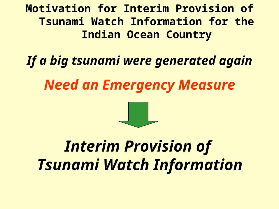
Motivation for Interim Provision of Tsunami Watch Information for the Indian Ocean Country
Interim Provision of Tsunami Watch Information
Need an Emergency Measure
If a big tsunami were generated again
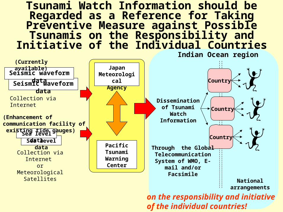
Tsunami Watch Information should be Regarded as a Reference for Taking Preventive Measure against
Possible Tsunamis on the Responsibility and Initiative of the Individual Countries
Sea level dataSea level data
Japan Meteorological
Agency
Collection via Internet
Country
Dissemination of Tsunami Watch
Information
PacificTsunamiWarningCenter
Collection via Internet or
Meteorological Satellites
Seismic waveform data
Seismic waveform data
Country
Country
Through the Global Telecommunication
System of WMO, E-mail and/or Facsimile
(Currently available)
(Enhancement of communication facility of existing tide gauges)
National arrangements
Indian Ocean region
on the responsibility and initiative of the individual countries!

India
Indonesia
Australia
Malaysia
Thailand
Myanmar
Bangladesh
Iran
Pakistan
Oman
Yemen
UAE
Sri Lanka
Maldives
Singapore
Mozambique
East Timor
Seychelles
South Africa
Tanzania
Kenya
Reunion Island
Chagos Archipelago
Mayotte Island
Kerguren Island
Amsterdam Island
St. Paul Island
Mauritius
Madagascar
Comoros
Crozet Island
Australia MozambiqueBangladesh MyanmarComoros OmanEast Timor PakistanFrance SeychellesIndia SingaporeIndonesia Sri LankaIran South AfricaKenya TanzaniaMadagascar ThailandMalaysia United ArabMaldives UnitedMauritius Yemen
Recipient Countries

• Source Parameters– Origin time (UTC),
Coordinates (latitude, longitude), Location name of the epicenter , Depth (if 100km or more), magnitude
• Evaluation of Tsunamigenic Potential
• Estimated Tsunami Travel Time
• Observations of tsunami
Contents of TWI

Sea Level Stations in the Indian Ocean

Colombo
Male
Hanimaadhoo
GanPort LouisePort La Rue
Salalah
Sea level data ( Indian Ocean)
1m
Sea Level Data of M8.7 Sumatra Earthquake on 28 March in the Indian Ocean
3/29 3/30 JST

The Northwest Pacific Tsunami Advisory and the Tsunami Watch Information
Issued since March 2005
Advisory Origin Time(UTC) Latitude Longitude M Issued Time(UTC)
TWI 2005/ 4/ 10 10:29 -1.1 99.4 6.8 2005/ 4/ 10 10:56
TWI 2005/ 4/ 16 16:38 1.9 97.8 6.5 2005/ 4/ 16 16:59
TWI 2005/ 4/ 28 14:07 2.2 96.9 6.6 2005/ 4/ 28 14:30
TWI 2005/ 5/ 14 5:05 0.7 98.7 6.8 2005/ 5/ 14 5:32
TWI 2005/ 5/ 19 1:54 2.0 97.0 6.6 2005/ 5/ 19 2:15
TWI 2005/ 7/ 5 1:52 1.9 97.0 6.7 2005/ 7/ 5 2:15
TWI 2005/ 7/ 24 15:42 8.7 92.1 7.3 2005/ 7/ 24 16:02
NWPTA 2005/ 8/ 16 2:46 38.1 142.4 6.8 2005/ 8/ 16 2:55
NWPTA 2005/ 9/ 9 7:27 -4.6 153.3 7.3 2005/ 9/ 9 7:56
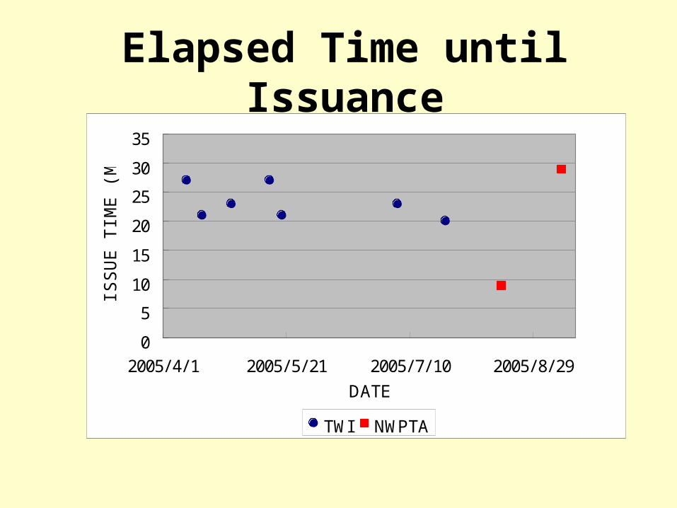
Elapsed Time until Issuance
0
5
10
15
20
25
30
35
2005/ 4/ 1 2005/ 5/ 21 2005/ 7/ 10 2005/ 8/ 29
DATE
ISSU
E T
IME (
MIN
.)
TWI NWPTA
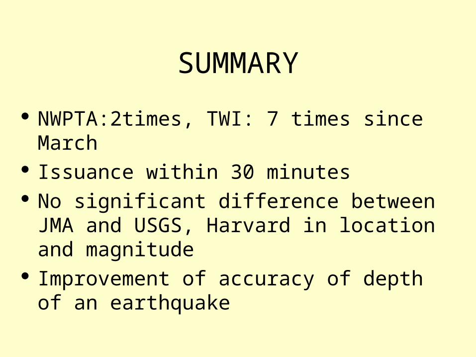
SUMMARY
NWPTA:2times, TWI: 7 times since March Issuance within 30 minutes No significant difference between JMA and
USGS, Harvard in location and magnitude Improvement of accuracy of depth of an
earthquake