itto · · 2014-05-14international tropical timber organization title serial number committee...
TRANSCRIPT

INTERNATIONAL TROPICAL TIMBER ORGANIZATION
TITLE
SERIAL NUMBER
COMMITTEE
SUBMITTED BY
ORIGINAL LANGUAGE
SUMMARY
ITTO PROJECT DOCUMENT
DEVELOPMENT AND INSTALLATION OF A FOREST RESOURCES MONITORING SYSTEM (FORMS) BY UTILIZING THE FOREST CANOPY DENSITY (FCD) MODEL DEVELOPED IN ITTO PROJECT PD 66/99 REV. 1 (F)
PD 239/03 Rev.1 (F)
REFORESTATION AND FOREST MANAGEMENT
GOVERNMENT OF REPUBLIC OF THE PHILIPPINES -DENR REGION IV CALABARZON1
ENGLISH
Access to reliable, up-to-date information on forest status is a fundamental requirement for efficient forest management. Without adequate information, decision-makers are not well guided in the prioritization of project development interventions and prevention of illegal logging. Conventional methods for assessing forest status are time-consuming and expensive. Moreover, these methods usually focus on discrete areas and do not provide the comprehensive overview needed for a strategic approach to forest management. To address these problems, DENR-IV will develop and install a Forest Resources Monitoring System (FORMS) to achieve efficient, cost-effective planning and monitoring. Central to operations ofthe FORMS will be the utilization ofFCD-Mapper, an image analysis software developed in ITTO projects. Development of FCD-Mapper began in Project PD 13/97 Rev. I (F) with DENR participation through the National Mapping and Resource Information Agency (NAMRIA). Further enhancement ofthe software was pursued in Project PD 66/99 Rev.} (F). DENR has been continually updated 'on the enhancements in the software and two DENR staff were previously trained by the Japan Overseas Forestry Consultants Association (JOFCA) in use ofthe software. Development of FORMS will highlight technology transfer through training to impart skills in the operation ofFCD-Mapper. Furthermore, the operations manual for FCD-Mapper, will be edited where necessary to help facilitate 'user-friendly" application. Likewise, geographic information system (GIS) operations wil be incorporated for purposes of establishing a computerized data filing/storing/retrieval capability as a major component of the FORMS.
Next to Metro Manila, DENR-IV has the second highest density of human settlements, population and industrial development in the Philippines. The DENR-IV region is adjacent to central government departments and agencies. It thus has the potential to become the country's alternative major center for decision-making and policy formulation on forest management. Given the crucial issues of human population, settlements/residential areas and economic activities, periodic monitoring ofthe forest status and watershed catchment areas including changes through time will be a primary focus of FORMS operations.
EXECUTING AGENCY
COOPERATING GOVERNMENTS
DURATION
APPROXIMATE STARTING DATE
BUDGET AND PROPOSED SOURCES OF FINANCE
DENR REGION IV
24 MONTHS
TO BE DETERMINED
Source
ITTO Gov't of the Philippines
TOTAL
Contribution inUS$
347,118 96,380
443,498
Local Currency Equivalent
1 "Calabarzon" is an acronym for the provinces ofCavite, Laguna, Batangas, Rizal and Quezon. For brevity, elsewhere in this document, DENR IV will mean DENR IV -Calabarzon.

1. Origin
PART I CONTEXT
2
This proposal evolved from the need to streamline and systematize the gathering and management of important forest sector data for decision-making, planning, management, and monitoring. The proposal also responds to the opportunity to dramatically improve informationgathering methods by utilizing satellite imagery analysis software developed by an ITTO project. Related to these needs and opportunities are the requirements for skills development through training tailored to help ensure efficient forest management.
2. Sectoral Policies
Implementation of the proposal will enhance the design and monitoring of forestry sector programmes and projects that pursue goals set forth in the following documents:
Provisions ofthe 1987 Philippine Constitution on Environment & Natural Resources; Presidential Decree (PD) 705 (Philippine Forestry Code as amended); Executive Order (EO) No. 192 (Reorganization of the Department of Environment & Natural Resources - DENR); Philippine Strategy for Sustainable Development; and Philippine Master Plan for Forestry Development (MFPD) and the DENR Region IV Master for Forestry Development (RMFPD)
The 1987 Philippine Constitution and PD 705 as amended establish the overall guidelines governing management and utilization of forest resources. Among others, EO 192, mandates the DENR to recommend, formulate and implement policies, programmes and projects that contribute to provision of a sustainable and continuous supply of forest goods, services and amenities.
The MPFD (1990) is the national guide for the long-term development of the forestry sector in the Philippines. The RMPFD for DENR-IV translates the MFPD into an action agenda for the region that conforms with the following principles and objectives of the MFPD:
• To attain equitable access for all Filipinos to opportunities to develop and manage the forest and partake of benefits derived from it;
• To achieve scientific management, conservation, and utilization of forest resources by the private sector and the local communities in partnership with the national government; and
• To provide on a sustainable basis, forest-based commodities, services and amenities to the people.
The proposed FORMS is an institutional development initiative. It supports logical decisionmaking, policy formulation and well-planned interventions in forest conservation, development and management. Essential for successful implementation of FORMS is the ability to keep abreast of the changing needs and demands of the people and the environment. This will require a solid platform of information, planning, methodologies, administration, research and development. Also crucial are the capability to carry out analysis to guide the decision-making process, and to communicate effectively with all concerned stakeholders. Investments in information technology can contribute in a meaningful way to development of these capabilities. Due to its involvement in FCD-Mapper development, DENR has kept abreast in the potential uses of satellite imagery analysis methods that will be an integral component of FORMs.

3
3. Programmes and Operational Activities
National forestry sector programmes include components that, inter alia, deal with watershed management, forest and wildlife conservation and forestland rehabilitation. Social factors such as population pressure and alleviation of rural poverty are relevant in the formulation of these programmes and are manifested by the importance placed on community-based forest management, agroforestry and income-generation projects. Within this national framework, DENR-IV (and other regional offices) are responsible for recommending policies, proposing plans and programmes, designing projects and establishing operating standards to promote achievement of objectives.
Guided by decisions taken at the national and regional levels, the DENR Provincial and Community Environment and Natural Resources offices (PENRO/CENRO) are responsible for project implementation. Additionally, the PENRO and CENRO offices are the principal sources of information that provide "raw material" for decision-making in the Regional Office and ultimately at national levels. Thus, active participation and involvement by PENROs/CENROs in the FORMS is essential. The experiences and lessons learned in setting up FORMS for DENR-IV can guide other regional offices that must deal with similar concerns and whose operations are affected by similar limitations in terms of reliable data on the status of forest conditions.
1. Project Objectives
1.1 Development Objective
PARTll THE PROJECT
The Forest Resources Monitoring System (FORMS) Project is envisioned to provide a mechanism that supports efficient management of forest resources by (among others) enabling decision makers to access information on the actual status of the forest conditions in real time. The FORMS will collect, organize and document facts and figures on current and past forest conditions. These information will be disseminated to concerned stakeholders in user-friendly formats including colored-coded maps. The project will integrate all information vertically along the regional hierarchy and horizontally across the forestry administrative functions to provide a total view of the DENR-IV forestry sector.
1.2 Specific Objectives
To establish a remote sensing based system for assessment and monitoring of forest resources.
1 Project Justification
1.2 Problems to be addressed:
The current database for decision-making, planning and monitoring in DENR-IV is incomplete and/or obsolete. This is due principally to reliance on conventional methods for obtaining and managing information such as manual preparation of maps, data storage and filing. These methods are personnel intensive, costly and slow, making it impossible to keep pace with changing conditions. Thus, decisions on fund allocation and programme/project design are often based on outdated information or dubious assumptions. Useless dissipation of scarce funds, and negative repercussions from erroneous decisions, are inevitable consequences of this situation. For example, application of plantation-type reforestation on watersheds despite the existence of conditions favorable for assisted natural regeneration (ANR) which can restore the desired vegetation density at much lower costs.
4
Modem information technology (IT), analysis of satellite imagery data, on-screen mapping, and data storage/filing/retrieval methodologies are viable alternatives to the outmoded systems currently in use. However, the human resource skills needed to employ these options are still under-developed. Additionally, budgetary limitations curtail the procurement of satellite imagery data, computer hardware, software and related peripherals that would enable DENR-IV to install a new, responsive data management system, and thereby strengthen management, decision-making and monitoring. The absence of a satellite data analysis capability is a particularly crucial problem since this deficiency makes it difficult to rapidly verify information on forest status submitted by subordinate offices (i.e. PENRO/CENRO).
All of the above hinder the capability of DENR-IV to comply with its informationrelated obligations to the public. For instance, it is not possible to respond confidently to requests from Provincial Governors, City or Municipal Mayors and their respective planning offices for reliable data on forest cover, provincial/city/municipal administrative boundaries, and watershed conditions. Similarly, requests from furniture shops and other wood processors for data on the location, volume of timber, availability of tree farms and plantations cannot be easily provided. In addition to obsolete information, responses to requests are slow due mainly to an archaic data storage/retrieval system. Compounding this problem is the occasional loss of manually-prepared maps and other information, and the absence of back-up copies due to lack of electronic storage/retrieval and digitization capacity.
1.3 Intended Situation after Project Completion
After completion of the project, the FORMS will be in place and functioning at DENR Regional, PENRO and CENRO offices. Trained staff will be on board at each of these levels. Staff will be conducting satellite imagery data analysis using the FCD-Mapper semi-expert system software. The results (i.e. color coded maps and data tables) will be provided to DENR management at all levels and to other interested stakeholders including local government units (LGUs), non-government organizations (NGOs) and the public. Processed spatial data and output, including thematic maps, will be available for easy reference in decision-making, planning and monitoring. Expeditious monitoring of change in the status of forest resources will be feasible and practical. This will help foresters and decision makers predict trends and monitor forest conditions at minimum cost. Of particular value in this regard will be the multi-temporal analysis capabilities of FCD-Mapper ver. 2 which, via its geometric correction functions, ensure that the location reference points on one set of satellite data correspond with locations of the same reference points on data sets taken at different seasons and different years. Other components of the FORMS will be GIS operations, digitized map preparation and an efficient data filinglstoragelretrieval system.
DENR-IV will be the regional repository of all forest resources data in the Calabarzon provinces. Computerized data and digital maps will enable planners to better predict future trends, and design more effective programmes/projects for watershed rehabilitation, illegal logging monitoring, forest conservation and management. Reports will be transmitted through electronic mail or wide area network (WAN). The DENR-IV FORMS will serve as a model for replication by other regional offices. Further, DENR IV will conduct regular site assessment even after the project operation on the established study plots in order to ensure that data captured through remote sensing reveal same information if validated on the ground such as increase or decrease in forest cover, species stocking enhancement, etc. The following outcomes are expected from implementation of the project and its sustainability:

5
Ensuring data integrity
• Training in operations of the FCD-Mapper will include ground validation tests to confirm that trainees have learned how to correctly operate the software. Concurrently, ground validation may identify options for further application of the software in addition to options already identified;
• GPS equipment will be used in ground validation and related operations that require accurate pin-pointing of exact locations;
• Forest resources data at all levels will be synchronized to the extent that is technically feasible;
• Procedures and guidelines in data collection, storage and retrieval as well as transmission and upward integration will be properly defined and implemented at all levels of the DENR-IV organization.
Facilitating optimum data access rights to all potential users
• The system will have well-defined protocols for access to reliable information, providing maximum possible data access to users while keeping confidentiality and data integrity in areas where necessary; and
• Greater flexibility in the use of data. Creating awareness of the system and promoting use by all concerned parties
• Establishment of an organized data repository; • Development and installation of a computerized directory and simple "search engine"
enabling quick and easy access by users; and • Data ownership, accountabilities and responsibilities are clearly defined.
Providing timely, up-to date information
• Strategic and operational support for obtaining reliable data; • Maximizing use of the FCD-Mapper • Operational spatial support to facilitate programme/project implementation, trouble
shooting and monitoring; • Integration of GIS data.
Providing Continuous Research
• Established permanent plots will be maintained to serve as study area for collection and analysis specifically on increase/decrease offorest cover
• Ground truthing will be conducted periodically on the identified established study plots to validate the data captured through remote sensing
• Periodic report and publication of data derivedlanalyzed will be done monitor/assess FeD technology development
2.3 Project Strategy
The project will follow an interactive process of
• Data inventory • Procurement of hardware, software and satellite imagery of data • Installation of hardware and software • Methodology and systems formulation at the regional office;
to

6
• Provisional stratification using FCD-Mapper • Field validation studies; • Refinement in the regional office based on data collected; • Training of trainers including implementation of application tests; • Additional refinement of the operations manual as required; • Review of each stage culminating in major technical training events, seminars and
workshops; • Production and reproduction of thematic maps.
Regional, Provincial and Municipal foresters will be designated as members of the Task Force responsible for FORMS development and installation. The team will also be responsible for collaboration with DENR Main Office and related agencies such as the National Mapping Resource Information Administration (NAMRIA). Additionally, it will identify the sites in each province and community where field validation studies and application tests will be carried out. These studies and tests will be implemented as follows:
• Collection and review of relevant forestry related information covering the study/test sites;
• Ground truthing in each different forest type and management class to check correlation with the provisional stratification using FCD-Mapper;
• Trial studies-cum-training-tests on monitoring the change in forest status by means of the multi-temporal analysis functions in FCD-Mapper; and
• Follow-up studies/training/tests out at the same area to verify results of previous application of the methodologies and outcomes of data analysis.
Application tests will be conducted in all Philippine forest types existing in the region: e.g. mossy, montane dipterocarp, lowland dipterocarp, and coastal/mangrove. Specific locations of the study sites will be decided in consultation with provincial and municipal counterparts during field assessment/evaluation trips. The major aspects considered in defining the sites are as follows:
• No constraints in accessibility to conduct study/application tests;
• Existence of different forest types, e.g. mossy, montane dipterocarp, lowland dipterocarp, coastal/mangrove sites, plantation forests (private lands), industrial forest plantations (public lands), and community based forest areas.
• Detailed information on the ground related to forest management are available, and
• No other critical issues such as security problems exist in the sites.
2.4 Target Beneficiaries
Primary stakeholders and beneficiaries of the FORMS will be the policy and decisionmakers of DENR-IV and DENR Central office. National stakeholders/beneficiaries will include concerned government agencies e.g. Congress, National Economic and Development Authority (NEDA), NAMRIA, provincial, city and municipal executives and planning bodies and private sector organizations such as the Philippine Wood Producers Association (PWP A), local investors, non-government organizations (NGO), the academe and research agencies. FORMS data will also be useful for overseas investors and international organizations including ITTO, Food and Agriculture Organization (FAO), United NationslECE, European Union, the World Bank and other donors. The ultimate beneficiaries will be the residents of

7
Region 4-Calabarzon whose lives will be improved as a direct result of better forest management.
2.5 Technical and scientific aspects
Forest Canopy Density Mapping (FCD) Model was first discovered as a tool to classify degree of deforestation and rehabilitation in ITTO Project PD32193 Rev. 2(F), "Rehabilitation of Logged-over Forests in Asia/Pacific Region, Sub-project IIL" The methodology pays attention to the value of four (4) parameters that are computed through analysis of Landsat data. They are namely vegetation, bare soil, shadow and temperature. The values representing these parameters are combined to stratify an area into canopy density categories.
The methodology was then programmed as a software called the "FCD-Mapper" that is compatible with Windows type personal computer for ITTO Project PD 13197 Rev.1 (Dessemination of New Remote Sensing Methodology through a Semi-Expert System," The software enables foresters with no special skill on remote sensing analysis to analyze the sattelite data to develop an FCD Map for the area of interest.
The studies on FCD Mapper were conducted in different forest types and under different ecological conditions. Results of the studies verified that outputs obtained from data processing using FCD-Mapper were highly acceptable in terms of accurately quantifying the degree of forest canopy denSity, efficiency, user-friendly features and practical utilization of the data obtained Furthermore, studies demonstrated the potential for significant savings in time and expense by eliminating the need to establish "training areas" before conducting analysis through time consuming process of ground-thruthing.
While Forest Canopy density (FCD) refers to the proportion of an area in the field that is covered by the crown of trees, it is expressed in percentage of the total area. In general practice, FCD is a measurement determined by an experienced forester through observation of the canopy layer at the zenith from his or her standing point. On the other hand, FCD generated from satellite data is the proportion of the space identified as forest canopy within one (1) pixel of a satellite image. Pixel size of the LANDSAT-lM data is 30x30 meters. The value (i.e. proportion) offorest canopy density computed in each pixel is arranged in a grid to produce a forest canopy density map. These values can be applied to compute the forest canopy density for each forest compartment, each forest management unit, and the entire area that is being assessed
Accuracy of this method was verified in the results of tests in India, utilizing FCD Model. In these tests, two (2) types of map were developed One (1) map presented classification into broad land-cover types. The second map classifiedforest canopy density as well as land-cover types. Information contained in the maps was evaluated and compared with data on actual ground conditions derived from numerous sample plots assesses by traditional forest inventory methods. The over-all accuracy of the first map (i. e. FCD 80%; 60-80%; 40-60%) accuracy wasfound to range between 93% and 95%. In the second dimension, classification of the remaining categories (i.e. FCD 20-40%; 10-20%) ranged between 82 and 85%. The over-all classification accuracy of the map showing land-cover types and forest canopy density was 89.4%.
The use of semi-expert systems to help analyze imagery data in forestry is a relatively new development. Results derived from multi-temporal analysis capability incorporated in the

8
FCD-Mapper semi-expert system will help monitor the changing status of degradation/regeneration in forest lands. These systems combine the knowledge and expertise of a technical specialist with the practical in sights of field staff Development of semi-expert systems is a tedious, time consuming task. However, once in place, they are easy to use and produce accurate results. Thus, the benefits of scientific inquiry are broadly-shared.
The project proposes to attain its objectives through parallel efforts in both aspects of RS analyses: (i) automation, and (ii) the manual inputs needed to support and ensure success of the automation component.
FORMS will be a RS-based system that involves hundreds of data entries with thousands of possible occurrences. Thus, information technology (IT) will play an important role in the solution of problems concerning management of spatial data. Full IT implementation at the Regional, PENRO and CENRO office levels will greatly facilitate data management. Adopting the Management System Architecture, the FORMS will take the following into consideration:
2.5.1 Spatial Data • Harmonized spatial data covering five provinces; • Data integration and sharing within the DENR organization • Ready access to spatial data by other potential users • Compatibility of forestry spatial data generated by the system with GIS systems.
2.5.2 Processess • Spatial data capture covering five provinces • Spatial data storage, retrieval, processing and manipulation done at all levels usmg
information technology • Spatial data transmission methods utilizing the developed communications infrastructure; • Spatial data query primarily through the developed system.
2.5.3.1 People • Computer literate personnel handling the spatial information • IT positions at all levels are institutionalized
2.5.4 Technology • Appropriate hardware and software supports the system
2.6 Economic Aspects
Sustainable forest management is crucial to economic development. Efficient and logical planning, along with reliable assessment and monitoring, are essential ingredients of good management. In these contexts, timely provision of accurate data is a fundamental requirement in the decision-making process. The project will provide improved methodology for analysis and dissemination of data, thus making indirect but important contributions to economic development.
2.7 Environmental Aspects
The availability of accurate, reliable and timely spatial data will inform planners and decision makers on situations that demand prompt action regarding the proper management and protection of forests. Total imagery coverage documenting the status of forests will become easily accessible to policy/decision-makers and civil society organizations at regional, provincial and municipal levels,.

9
Conservation of environmental values is a major dimension of forest management. The ability to monitor change in forest conditions over time enhances the capability to identify site-specific targets that require implementation of environmental conservation initiatives. Accurate and timely analysis of satellite imagery data provides a practical, cost effective method for target site identification. Project outputs will help simplify analysis, strengthen analysis capability and improve the data base for formulation and design of environmental conservation programmes.
2.8 Social Aspects
Prospective investors will have easy access to spatial data information on various aspects of the resources. This can help expedite decisions that generate employment for forest dwellers and others who are currently jobless. Likewise, conservation and reforestation works/activities can be planned with increased precision and focus. For example, multitemporal analysis will indicate more clearly the rate of disturbance or regeneration status on the map with different colors showing the reality of prevailing conditions. This can immediately call the attention not only of the decision makers but also the public audience. Recognition and better understanding of the situation will help attune the development strategies of land use programs in ways that benefit affected rural communities.
2.9 Risks
Personnel trained to operate FORMS could be re-assigned to other jobs. This may be a potential risk. Spatial and imagery information technology responsibilities are a function of designations (i.e. TORs) rather than positions (i.e. official DENR appointments). At present there are no approved permanent positions for RS and IT staff To minimize this risk, Special Orders and Administrative Orders will be issued by DENR management to institutionalize the units and retain the trained personnel in their respective designations. Annual budget submissions to the national government will include appropriations for statistical activities to sustain the system. User's manuals and system documentation will be updated regularly to facilitate continuous training of new personnel (as needed).
3. Outputs
3.1 Specific Objective 1
To establish a remote sensing based system for assessment and monitoring of forest resources
Output 1.1 - Implement skills development programmes for analysis of RS data, spatial data outputs and related forestry sector information by personnel from the regional, provincial and community offices of DENR-IV who shall comprise the human resources needed to develop and implement FORMS.
- Output 1.2 - Manual of operations for forest inventory to use in conjunction with FCD Mapper Operations
Output 1.3 - Revised and simplified user's guide for operating FCD Mapper
3.2 Specific Objective 2
To develop personnel skilled in utilization ofRS-based system
Output 2.1 Output 2.2 Output 2.3
- Training and deployment of 40 personnel on FCD Mapper operation - Training & deployment of 60 personnel on GIS - Training and deployment of 88 personnel on computer systems

10
4. Activities
4.1 Output 1.1 RS-based system in place
- Activity 1.1.1 - Hardware and software procured and installed - Activity 1.1.2 - Procurement of TM data scenes - Activity 1.1.3 - Orientation on operation of the enhanced FCD Mapper
Output 1.2 Manual of operations for forest inventory to use in conjunction with FCD Mapper operations
- Activity 1.2.1 -- Activity 1.2.2 -- Activity 1.2.3 -- Activity 1.2.4 -- Activity 1.2.5 -
Selection and establishment of testing sites Development of assessment parameters Ground truthing to confirm applicability of the FCD Mapper Develop assessmentlinventory methodology Production and distribution of Manual
Output 1.3 Revised and simplified user's guide for operating the FCD Mapper
- Activity 1.3.1 - Simplify existing guide - Activity 1.3.2 - Production and distribution of guide
Output 2.1 Training and deployment of 40 personnel on FCD Mapper operation
- Activity 2.1.1 - Establish criteria for selection of trainees who have capability to become trainers
- Activity 2.1.2 - Nominate and select trainees - Activity 2.1.3 - Conduct training
Output 2.2 Training and deployment of 60 personnel on geographic information systems
- Activity 2.2.1 -
- Activity 2.2.2 -- Activity 2.2.3 -
Establish criteria for selection of trainees who have capability to become trainers Nominate and select trainees Conduct training
Output 2.3 Training and deployment of 88 personnel on computer systems
- Activity 2.3.1 - Establish criteria for selection of trainees who have capability to become trainers
- Activity 2.3.2 - Nominate and select trainees - Activity 2.3.3 - Conduct training
Output 3.1 Production and distribution of maps showing the currentforest status and trends - Activity 3.1.1 - Data processing using FCD-Mapper - Activity 3.1.2 - Ground truthing - Activity 3.1.3 - Data validation
Activity 3.1.4 Data filing! storage/retrieval/database management and image processing Activity 3.1.5 Printing and distribution of maps to all levels ofDENR-IV operations
5. Logical Framework (Please see Annex 1)
6. Work Plan
Project implementation will consist of four (4) principal components:
procurement of hardware, software and satellite imagery data;
training;
development and installation of the FORMS; and
utilization and dissemination.
11
The projected sequence of activities in these components is presented in Annex 2 (Work Plan Matrix. Description of the activities is presented below.
6.1 Procurement
Standard government procedures will be followed to purchase the computers (i.e. hardware) required for project implementation: viz. definition of specifications, canvassing, evaluation of bids, and actual purchase. The computers will be installed in the three (3 levels of DENR-IV operations; i.e. regional office, PENRO and CENRO.
Procurement procedures for software (the FCD-Mapper) and satellite imagery data will be generally consistent with the standard procedures. However, canvassing and evaluation will be less stringent because these are single-source commodities; the ITTO-authorized supplier/licensee for FCD-Mapper and LANDSAT for the imagery.
6.2 Training
This component will begin with a "training-of-trainers" exercise to be carried out under sub-contract by experts who were directly involved in development of the FCD-Mapper. They will teach use of the FCD-Mapper to senior-level personnel of DENR-IV who are already familiar with standard satellite imagery analysis procedures but have not yet received training in application of the FCD-Mapper. In addition to DENR-IV personnel, the "trainer" participants will include staff from other offices such as NAMRIA and from national planning offices, including the central office of DENR. It should be noted in this regard that a limited number ofNAMRIA and other DENR personnel were previously trained in application of the earlier version of FCD-Mapper. These individuals will be included among the ''training-oftrainers" participants to acquire the additional knowledge and skills needed for operating the updated version ofFCD-Mapper.
The "trainers" will replicate training for colleagues in the DENR-IV organization working at the various operational levels; i.e. regional, PENRO, CENRO. At three-month intervals, experts hired through the sub-contract will return to the Philippines to monitor results of the training conducted by the "trainers" for their colleagues and offer assistance as needed to improve results.
Additionally, the project will call on competent resource persons from NAMRIA and the academe to assist in the replication process. Replication of training will begin as soon as the "trainers" have completed their training.
Even prior to the ''trainers-training'', most senior-level selected to become "trainers" will already be familiar with the potential uses of satellite data analysis. However, personnel at the PENRO and CENRO levels will need to gain both (i) skills in application of the methodology, and (ii) confidence that use of technology has practical and realistic relevance to their normal duties. This combination of skills development and confidence building will be achieved through a test-and-demonstration approach. Sites characterized by a range of conditions and forest types will be selected as venues for the training-cum-confidence building exercise.
Trainees whose normal duties can benefit from application of RS-based systems will be identified at the different levels of operations and participate in a "hands-on" training process. In addition to training in use of the FCD-Mapper, standard forest assessment procedures (inventory, etc) will be conducted to illustrate the close correlation between results of the imagery analysis and actual field conditions.

12
6.3 Development and installation of the FORMS
FORMS will utilize the capabilities of satellite-imagery analysis and GIS to create a database that includes all available information relevant to planning, implementation and monitoring in forest management. Thus, in addition to the training mentioned above (6.2) the project will develop data storage, access and retrieval systems, as well as appropriate protocols and procedures.
6.4 Utilization and dissemination
Immediately after completing training, the trainees will begin production of the maps, tables and analysis relevant to their respective jurisdictions. For example, each CENRO will produce the outputs covering its geographic area of operations. Maps, tables (etc.) will be generated on scales appropriate for the concerned office. This data will move upward through the FORMS, from the CENRO, thence PENRO and Regional Offices. Ultimately, the data will be provided to the DENR central office and other national agencies (e.g. NAMRIA, NEDA).
In addition to furnishing the above-mentioned offices with useful information, transmission of the data will aim at encouraging adoption of the FORMS in all DENR regions and other agencies that have planning and monitoring responsibilities. It is anticipated that other prime users of FORMS-generated information will be planners working for provincial, city and municipal governments, and in regional development councils. The project will actively promote the use of FORMS data by these offices through both formal and informal channels. Participation in provinciaVcity/municipal planning workshops is a normal function of DENR offices. These events will provide venues for dissemination and may encourage parallel development of similar systems and/or utilization of the FCD-Mapper at these various levels.
Specifically for DENR-IV, utilization ofFCD-Mapper and the other FORMS components will be incorporated in the annual planning required of all DENR offices as part of the budget preparation-submission process. Furthermore, the results of satellite imagery data analysis will have immediate application in monitoring of the forest status and environmental concerns (e.g. watershed management, conservation of wildlife habitat).
7. Budget
The overall budget is presented in Annex 4. Budgets by activity are shown in Annex 5. To maximize resources provided by ITTO, existing hardware and software within the DENR that are supportive to this project will be used. The estimated costs for the required hardware and software procurement are provided in Annexes 6 and 7, respectively. In addition, breakdown of the costs of training modules is shown in Annex 8.
PARTllI OPERATIONAL ARRANGEMENTS
1. Management Structure
Overall guidance will be provided by a Regional Executive Committee organized specifically for the project and chaired by the Regional Executive Director. Additionally, a National Expert in Information Technology will be engaged to advise on the technical aspects of implementation. Selected personnel from the DENR Region IV, PENRO and CENRO will compose the project team (Task Force). The terms of reference are appended in Annex 3.

13
1.1 Regional Office Level
The Forest Resources Development Division of the Regional Office will be responsible for day-to-day management and will report to the Chief of this division and the Regional Director. Two (2) groups will be formed within the division to oversee and support project implementation: Monitoring System Group and Technical Working Group.
1.1.1 Monitoring System Group
FeD Mapper installation
System Analyst Programmer
IT Officer
Image interpretation
Database Administrator Researcher/Operator
This group will have the following functions:
1. Manage the image and spatial data
Technical Support
System Administrator Technical Support Asst.
2. Provide training and technical assistance on the use ofFCD Mapper 3. Deploy appropriate applications; 4. Maintain all image and spatial databases and perform data audit to ensure data
integrity and completeness; 5. Ensure efficient utilization of network resources; 6. Provide remote and on-site support to subordinate offices; 7. Dissemination to other potential users and replication of additional training after
project completion.
1.1.2 Technical Working Group
The Technical Working Group will:
1. Revise and simplify the user's guide (manual) consistent with local requirements;
2. Regularly review rules governing utilization and dissemination of data to ensure conformity with current policies and guidelines;
3. Review forest resource trends through multi-temporal analysis and digital map information to identify problems and opportunities and ensure that outputs of analysis satisfy the data requirements of efficient forest management;
4. Initiate activities to attain project objectives including (as a priority) the provision of accurate information on the status of watershed in real time and thereby facilitate planning and management;
5. Propose and (if approved) implement additional applications ofFCD Mapper; 6. Perform imagery data audit at all subordinate offices and provide
recommendations to the Regional Director and the Regional Executive Committee on the conduct of image audit; and

14
7. Provide technical support to planning offices and management using FCDMapper as a tool to help them carry out their responsibilities.
2. Monitoring Reports and Evaluation
2.1 Arrangements for Reporting
The Technical Working Group will conduct monthly evaluation of the project, prepare monthly progress reports and submit the same to the Regional Executive Committee (REC). The REC will prepare a bi-annual progress report on project activities and submit the report to the ITTO through the Regional Executive Director. The REC will also prepare a Project Completion Report for submission to ITTO as soon as possible after project completion or as required. Reports to IT TO will be prepared according to the deliverables of project activities.
2.2 Arrangements for ITTO Monitoring and Review
The project will be subject to monitoring by representatives of ITTO as required. DENRIV management will assist and facilitate monitoring by the ITTO-designated representative.
2.3 Evaluation
Evaluation of project progress and outputs will be carried out pursuant to ITTO guidelines. Furthermore, DENR-IV management will seek assistance from other government agencies, the academe and/or civil society (e.g NGOs) to help ensure transparency and objectivity in the evaluation process.
3. Future Operation and Maintenance
At present there are no prior obligations that would impede commencement of project activities. Implementation will begin once funding is confirmed by the ITTO. This project will develop, install and implement the FORMS in the Regional, PENRO and CENRO offices. After project completion, operation of the FORMS will be incorporated and sustained as an integral part of DENR-IV operations, using financial resources provided through annual government appropriations. Budgets for FORMS operations will be included in annual budget submissions. Furthermore, the Monitoring Systems Group will identify options for replicating implementation within Local Government Units in the Calabarzon region and other DENR Regional Offices and actively promote adoption of FORMS by these offices.
PART IV THE TROPICAL TIMBER FRAMEWORK
1. Compliance with ITTA 1994 Objectives
Development and installation of the FORMS will support efficient management offorest resources by improving capability to bring about enhanced policy formulation and decision making based on reliable and accurate data. This project is consistent with the following objectives established in Article 1 of the ITT A:
(a) To provide an effective framework for consultation, international cooperation and policy development among all members with regard to all relevant aspects of the world timber economy;
(b) To contribute to the process of sustainable development;

15
(c) To promote and support research and development with a view to improving forest management efficiency of wood utilization as well as increasing the capacity to conserve and enhance other forest values in timber producing tropical forests;
(d) To encourage members to develop national policies aimed at sustainable utilization and conservation of timber producing forests and their genetic resources and at maintaining the ecological balance in the regions concerned, in the context of tropical timber trade; and
(e) To promote the access to, and transfer of, technologies and technical cooperation to implement the objectives of this agreement, including on concessional and preferential terms and conditions, as mutually agreed.
2. Compliance with ITTO Action Plan
This project is consistent with the ITTO Action Plan and is related to the priorities established by the ITTO Committees in the following areas:
Forestry sector policy reviews
Help for governments to develop appropriate policies for the forestry sector and to put in place measures to improve industrial efficiency and development and discourage wasteful and environmentally harmful practices
Development of manpower skills
Studies to provide needed information t 0 guide planning and policy formulation

ANNEX 1: LOGICAL FRAMEWORK WORKSHEET
I PROJECT ELEMENTS OBJECTIVELY VERIFIABLE MEANS OF IMPORTANT ASSUMPTIONS INDICATORS VERIFICATION
Develogment Objective Technology transfer and Transferred technology and Project workplans, There will be no major changes systems development to upgraded systems are being office reports and in the DENR organization strengthen capability at the utilized to strengthen planning, policies formulated structure or the national policies regional level of DENR monitoring, policy formulation and by DENR. that govern forest management operations in planning, decision-making. monitoring, policy formulation and decision making for sustainable forest management. SQ.ecific Obiectives Quick, reliable, significant and Copies of satellite Instal/ed FCD Mapper Semi-1. To establish a remote sensing accurate satellite images and maps, maps Expert System is operational based system for assessment spatial information are readily produced and and efficient
I and monitoring of forest available for planning, monitoring, policies drafted for resources management, decision making and sustainable
policy formulation management of I
I
forest. Outputs 1. 1 Development of personnel Skilled personnel operating and DENR R-IV Special Task Force members are able to !
skilled in utilization of RS-based maintaining the developed Forest Order assigning support the Regional Executive system Monitoring System and its facilities staff/human Steering Committee member in
resources at the technology development. I
Regional, Provincial and Community offices
1.2 RS-based system in place Cooperation and systematic FORMS The Region, PENRO and coordination among the Regional, establ ished and is CENRO offices are able to PENR and CENR offices have operational at the assess and monitor forest I
been institutionalized, data Regional, PENRO degradation and regeneration -------

1.3. Manual of operations for forest inventory to use in conjunction with FCD-Mapper operations 1.4 Revised and simplified user's guide for operating the FCD Mapper 2.1 Training and deployment of 40 personnel on FCD operation
2.2 Training & deployment of 60 personnel on GIS 2.3 Training and deployment of 88 personnel on computer systems
integrity, optimum access rights to I and CENRO offices all possible users have been
using the enhanced FCDMapper Semi-Expert System
facilitated, awareness of the system and its data content have been ensured and quick data reference have been provided
Existence of manual and other materials for use as references
Existence of user's guide I and other materials for use as references There are 40 personnel skilled in operation of FCD mapping, 60 personnel skilled in GIS analysis and 88 personnel skilled in computer system operation.
Office report/record I Reference materials are available.
Office I Reference materials are reports/records available.
DENR IV Special Personnel from the Regional, Order detailing PENRO and CENRO offices are personnel/staff in trainable and interested. the project; training reports, and certificate of attendance

Activities 3.1 Hardware and software User-friendly hardware and Smooth operation Reliable data output
procured and installed software of data processing 3.2 Procurement of TM data Availability of data Updated maps Data obtained are reliable scenes availability 4. 1 Orientation on operation of the Learned skill and application of Able to process Can interprete FCD-Mapper
I enhanced FCD-Mapper FCD-Mapper technology FCD-Mapper and operations I
data analysis 4.2 Selection and establishment of Site selected for field Delineated area of Sites are available and accessible I
testing sites application/testing location 4.3 Development of assessment Criteria of site Criteria Sites meets criteria requirement parameters listed/identified I
4.4 Ground truthing to confirm Selection of plots Permanent plots Site protected from threat of !
applicability of the FCD-Mapper are selected changelintrusion from other developmental activities I
4.5 Develop assessment/inventory Establish criteria to conform with Available Consistent inventory methodology methodology FCD-Mapper data processing inventory design design to be able to produce
(existing policy, reliable data studies, etc.)
5. 1 Production and distribution of Establish reference for non- Production of Manual are user friendly Manual trained user manual
I
- ~-

5.2Simplify existing guide Produce easy to follow Production of Increase user of FCD-Mapper reference revised guide technology
5.3 Production and distribution of Provision of immediate Availability of guide Distribution of guide among guide reference published directlindirect managers/planners
of forest resources
6. 1 Establish criteria for selection Technical personnel are Related knowledge Trained DENR-IV staff will be of trainees who have capability to provided priority for training retained in their appointed become trainers for RS positions 6. 1. 1 Nominate and select Reliable staff are selected Related knowledge
trainees 6.1.2 Data processing using FCD- Competent to process RS using Reliable data Trained DENR-IV staff will be Mapper FCD software retained in their appointed
positions 6.1.3 Data filinglstoragelretrievall Maps providing reliable Checking to Trained DENR-IV staff will be database management and image Information on forest status confirm availability retained in their appointed processing produced by utilization of the of maps and positions
upgraded FCD-Mapper. published references at the regional, PENRO and CENRO offices.
6.2 Conduct training for GIS/GPS Competent to process GIS/GPS Training Trained personnel are able to data completion process automated data on
GIS/GPS operations 6.2. 1 Data filing/storage/retrieval/ Maps providing reliable Checking to Competent, trained DENR-IV staff database management and Information on forest status confirm availability will be retained in their appointed GIS/GPS processing produced by utilization of the of maps and positions
upgraded FCD-Mapper. published references at the
"-_ regional, PENRO
----- _ .. __ ._._-

and CENRO offices.
6.3 Conduct training for Computer Competent to maintain data Data retrieval are Trained personnel are able to data Management/Maintenance bank efficient smoothly manage/maintain data
on file 6.3.1 Data management and In-place data storage Fast data retrieval Competent, trained DENR-IV staff
maintenance will be retained in their appointed positions
- -~

ANNEX 2. PROJECT WORK PLAN MATRIX FOREST RESOURCES MONTORING SYSTEM PROJECT

ANNEX 3. TERMS OF REFERENCE PROJECT SCOPE OF WORK
PERSONNEL Administrative Assistant 1. Formulate and implement information education
and communication activities to support the implementation of the project;
2. Coordinate the information technology training and manpower development programs of the project;
3. Recommend the manpower development requirement of the project;
4. Perform other functions as may be assigned. Secretary 1. Facilitate the conduct of meetings and filing of
records of the project; 2. Compile regular reports on the status and
progress work of the project; 3. Assist in the administrative and other support
services of the project. 4. Perform other functions as may be assigned.
Driver 1. Drive automobile and other vehicle of the project; 2. Picks up and transport project official and
personnel for official use; 3. Transport and assist in loading office machines
and equipment; 4. Keep and maintain the project vehicle clean and
roadworthy and make minor mechanical repairs of project vehicles;
5. Perform other functions as may be assigned. Messenger 1. Collect and delivers intra and inter office
correspondence, documents, packages, office supplies and other materials;
2. Run errands; 3. Perform clerical tasks such as filing cards, sorting
mail, maintaining a small stock and inventory of office supplies;

ANNEX 3. TERMS OF REFERENCE PROJECT
PERSONNEL Info System Analyst
Computer Programmer
I nfo Systems Researcher
Data entry Machine Operator
SCOPE OF WORK
1. Establish and recommend guidelines and procedures in the implementation of the activities of the project
2. Develop establish and recommend system documentation standards;
3. Conduct technical reviews of system development of the project and report recommendation to the Information Technology Officer;
4. Perform other functions as may be assigned. 1. Analyze program requirements, writes, codes, tests,
debugs and finalizes complex programming modules utilizing the most effective and efficient methods of programming;
2. Develop programs and modify existing programs as required;
3. Analyze existing programs and suggests specific improvement on program efficiency;
4. Prepare standard set of documentation for all completed programs;
5. Perform other functions as may be assigned. 1. Research on update in the computing technology
to keep abreast with new trends in the filed of information technology;
2. Assist in the development and establishment of system documentation standards;
3. Maintains the software and hardware component of the project;
4. Perform other functions as may be assigned. 1. Responsible for the input of data into the computer;
2. Validate and edit transcribed information; 3. Maintains the software and hardware component of
the project; 4. Perform other functions as may be assigned.

ANNEX 3. TERMS OF REFEENCE PROJECT SCOPE OF WORK
PERSONNEL National Expert 1. Determine and recommend approaches and
solutions to specific and present problems and issues in the over-all project implementation;
2. Recommend a system design that will take advantage of information technology advances;
3. Evaluate and make recommendation on the organizational capability enhancements necessary to implement the improvements of the project;
4. Perform other project-related duties and may be assigned by the Project Director;
Project Coordinator 1. Oversee and coordinate the over-all implementation of the project;
2. Provide guidelines, work directives, policies and administrative procedures of the management and operationalization of the project;
3. Review and recommend approval of the over-all operation of the project; and
4. Perform other functions that may be assigned by higher authorities.
Remote Sensing 1. Supervise the multi-temporal analysis and Specialist interpretation of satellite image data
2. Compile and prepare satellite image data indicating development recommendation
3. Organize all satellite image maps into a planning database;
4. Conduct training on remote sensing analysis for would be-users of the technology
5. Perform other functions that may be assigned. GIS Specialist 1. Supervise the translation of maps into digital
formats and conduct map overlay analysis as required
2. Prepare digital maps indicating development recommendations;
3. Organize all maps mapped information into a planning database;
4. Conduct training on GIS for would-be users 5. Perform other functions that may assigned.
Forester 1. Conduct selection of testing area 2. Conduct survey and collect data in testing areas 3. Conduct identification and inventory of species
covered in testing area 4. Perform other functions as may be assigned

ANNEX 4. PROJECT BUDGET - FORMS PROJECT
No. Ratel No.ofl TOTAL ITTO GRP COMPONENT Month ~onths
10 Project Personnel 11 National Experts
11-A Project Coordinator 1 1,000 24 33,600 24,000 9,600
11-8 Info Technology Officer 1 375 24 9,000 9,000 11-C GIS Specialist 1 375 24 9,000 9,000 11-0 RS Specialist 1 375 24 9,000 9,000 11-E Silviculturist 1 375 24 9,000 9,000 11-F Computer Programmer 2 300 24 14,400 14,400
12 Administrative Asst. 1 250 24 6,000 6,000
13 Secretary 1 225 24 5,400 5,400
14 Driver 1 200 24 4,800 4,800 15 Messenger 1 200 24 4,800 4,800
Trainings (No. of persons) -See Annex 8 188 31,520 26,790 4,730
Component Total 136,520 50,790 85,730 20 Sub-Contracts
21 Professional services of International Experts 48,750 48,750 -Component Total 48,750 48,750 -
30 Duty Travel 31 Daily Subsistence Allowance:
31-A International Experts ($120 per day X 40 days X4 experts) 19,200 19,200 31-8 National Experts ($30 per day X 168 days X 2 experts) 10,080 8,560 1,520
32 International travel ($700 per ticket X 17 tickets) 11,900 11,900 33 Transportation Cost ($1 OO/person X 4 persons/trip X24 trips) 9,600 8,160 1,440
Component Total 50,780 47,820 2,960 40 Capital Items
43 Vehicle (Pick-up) 18,000 17,000 1,000 44 Equipment Hardware (Details in Annex 6) 85,600 85,600
45-A LANDSAT 7 ETM Data ($800 per scene X 4 scenest 3,200 3,200 45-8 LANDSAT 5 TM Data ($2000 per scene X 8 scenes) 16,000 16,000 -
Component Total 122,800 121,800 1,000 50 Consumables Items
51 Raw materials (licensed software) 28,000 28,000 -53 Utilities ($100 per month X 24 months) 2,400 2,400 54 Office supplies ($100 per month X 24 months) 2,400 400 2,000 55 Communications ($50 per month X 24 months) 1,200 200 1,000
Component Total 34,000 28,600 5,400 60 Miscellaneous
61 Sundry ($100 per month X 24 months) 2,400 1,200 1,200 62 External audit ($2000 X 3) 6,000 6,000 63 Steering Committee Meeting ($300 per meeting X 2 meetings) 600 510 90
Component Total 9,000 7,710 1,290 80 ITTO Monitoring, Evaluation and Administration
81 Monitoring and Review Costs 12,000 12,000 83 Ex-post Evaluation Costs 10,000 10,000 84 Program Support Costs 19 648 19 648
Component Total 41 648 41 648 -GRAND TOTAL 443 498 347 118 96,380

ANNEX 5.1 BUDGET BY ACTIVITY REQUESTED FROM ITTO
i~JORqQ~~JJTS PROJECT SUB- DUTY CAPITAL CONSUMABLE MISC. , GRAND
No. PERSONNEL CONTRACT TRAVEL ITEMS ITEMS TOTAL
1 Establish a remote sensing based system for
assessment and monitoring of forest resources 48,750 47,820 102,600 28,600 7,710 235,480
2 Develop personnel skilled in utilization of RS-based system 50,790 50,790
3 Produce and distribute updated maps of forest status 19,200 19,200
Grand Total 50,790 48,750 47,820 1_21,800 28,600 7,71(! 305,470
--- - -- -- ---- ----- - ---- - -- -- - --- -
-

ANNEX 6. ESTIMATED COST OF HARDWARE REQUIREMENTS
REGIONAL OFFICE/PENR OFFICE PARTICULARS UNIT COST NO. COST
TOTAL COST 85,600 Data base Server 6,000 2 12,000 RS/GIS Files/Application Server 10,500 1 10,500 RS/GIS Station 7,700 6 46,200 Printers 400 6 2,400 Network Facilities/Accessories 14,500 1 14,500

ANNEX 7. ESTIMATED COST OF SOFTWARE REQUIREMENTS
REGIONAL OFFICE PARTICULARS UNIT COST NO. COST
TOTAL 28,000 File Server 2,000 1 2,000 RS/GIS Application Server 1,000 2 2,000 Data Server 5.000 1 5,000 Firewall/Securi!y Server 1,000 1 1,000 GIS 3,000 6 18,000
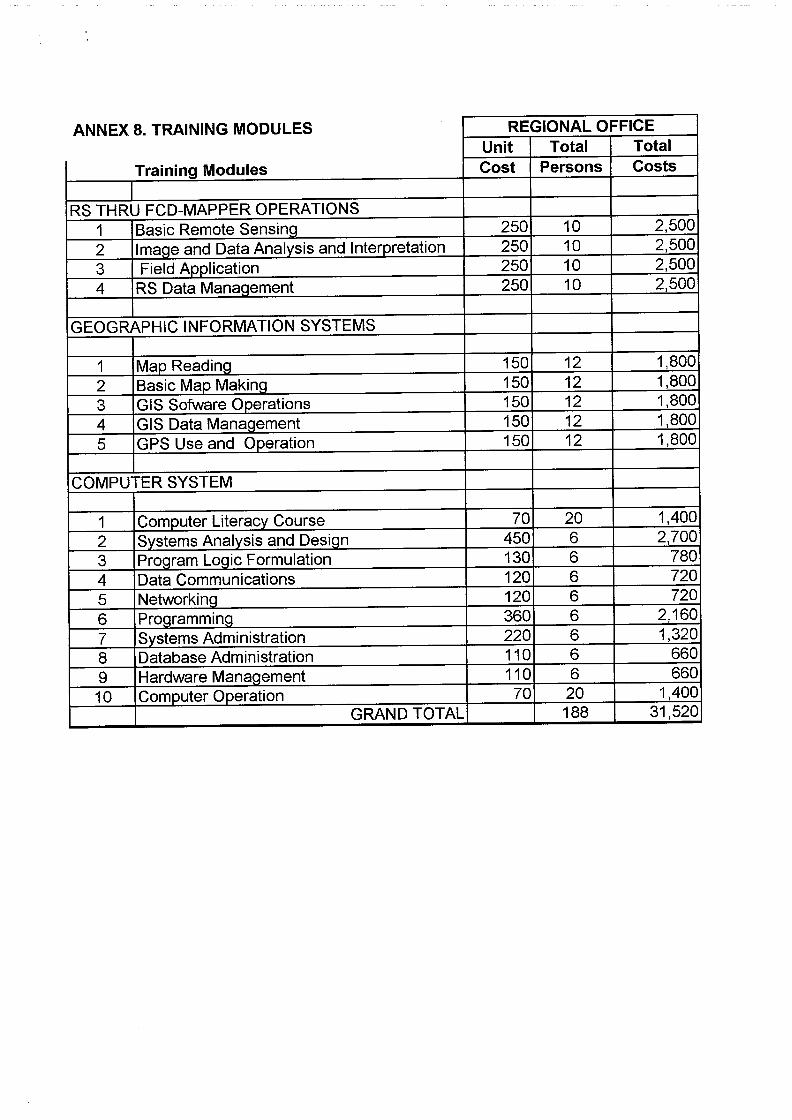
ANNEX 8. TRAINING MODULES REGIONAL OFFICE Unit Total Total
Training Modules Cost Persons Costs
RS THRU FCD-MAPPER OPERATIONS 1 Basic Remote Sensing 250 10 2,500 2 Image and Data Analysis and Interpretation 250 10 2,500 3 Field AJ)plication 250 10 2,500 4 RS Data Management 250 10 2,500
GEOGRAPHIC INFORMATION SYSTEMS
1 Map Reading_ 150 12 1,800 2 Basic Map Making 150 12 1,800 3 GIS Sofware Operations 150 12 1,800 4 GIS Data Management 150 12 1,800 5 GPS Use and Operation 150 12 1,800
COMPUTER SYSTEM
1 Computer Literacy Course 70 20 1,400 2 Systems Analysis and Design 450 6 2,700 3 Program Logic Formulation 130 6 780 4 Data Communications 120 6 720 5 Networking 120 6 720 6 Programming 360 6 2,160 7 Systems Administration 220 6 1,320 8 Database Administration 110 6 660 9 Hardware Management 110 6 660 10 ComQuter Operation 70 20 1,400
GRAND TOTAL 188 31,520

,(
,,'
ID'
".
".
.<
,,'
,,'
u' •
1" '.
It" .,
.d ,
f ,
" ,
"
112
."..
ANNEX 9. PROJECT LOCATION
MAP OF THIC 1)H1LIPPINES SHOWING THE LOCATION OF
DENR~ RE'GION IV CALABARZON , l'OLYC.oNIC 1'1~(),J1iCTI,()N
KILOM!TERS
u , ,
,.' ",
I', ~I' .,\i.
'.'"
/-\!-
~':~ ,
-113'
,;. .'
" (
,". J.; \
;I ...
."
" !' , ,
fI 0 Il
116' 111'
N
, '
~. 0
118' 119'
0: B:\TANFB
-;"
I' :,.,t" .. VU"'"
'fj
....
121' 122'
RI!GION IV CALABAIUON
C F L F. 11 t: s ;0,: £ 1
123'
\.~
\
m
,,'
••
,,'
,,'
,,'
r ,,'
.,
u'
".
,., ,,'
>.
10'
"
"
/.
"
(11\'1.4 ('ll~~-~.\(\It
i "
128'

ANNEX 10. RECOMMENDATIONS OF THE 26TH PANEL AND ITS MODIFICATIONS
Modifications made in the revised proposal [PO 239/03(F)] are summarized as follows:
Recommendations of the 26th Panel Modifications
1. Reduced specific objectives to the The specific objectives had been current Specific Objective 1 as current reduced (page 3), while objectives 2 Specific Objectives 2 and 3 are more and 3 were reformulated into outputs appropriately viewed as outputs and and activities accordingly (page 9 activities accordingly. and 10).
2. Develop logical framework matrix Developed logical framework matrix according Iy, with due attention to had been improved with due attention improving indicators and assumptions. to improving indicators and
assumptions (Annex 1). 3. Provide details on sustainability and Details on sustainability and
technical and scientific aspects of the technical and scientific aspects of the project. project had been discussed on page
5 and 7, respectively. 4. Revise and scale down the budget
using the newly defined project components in the following way: • Use realistic inputs and unit costs; The inputs and unit costs had been
reduced specifically for the allowance of the Project Coordinator, unit cost for vehicle and cost for equipment hardware (Annex 4' , Annex 6, respectivelyt
• Adjust ITTO monitoring and review The cost for the ITTO monitoring and costs to US$12,000 and include review costs had been adjusted and US$10,000 for ex-post evaluation US$10,000 for ex-post evaluation cost; cost had been included (Annex 4).
• Recalculate the ITTO's Program The ITTO's Program Support costs Support costs specified in the budget specified in the budget had been so as to conform to the new Standard recalculated following the new of 6% of the total project costs [ITTC Standard of 6% of the total project Decision 2 (XXX)]; costs[ITTC Decision 2 (XXX)] (Annex
4).
• Include a detailed consolidated Detailed consolidated yearly budget yearly budget by component and by component and source had been source, and prepared per attached Annex 5.1 and
Annex 5.2. 5. Include an Annex which shows the Annex 10. Showed the
recommendations of the 26th Panel and recommendations of the 26th Panel the respective modifications in tabular and the respective modifications in form. tabular form.