tropical ecology adventure centre (teac)
TRANSCRIPT

TROPICAL ECOLOGY ADVENTURE CENTRE (TEAC)Ecological Development GuidePasir Putih at Kotal Point
West Bali National Park
Buleleng | Bali | Indonesia
Prepared for:
Ben Tamblyn
Executive Director
Prepared by:
Jesse Froehlich
David Bird International Service Fellow, 2011
MA 2008, Conway School of Landscape Design
October, 2011

This document was prepared by Jesse Froehlich, David Bird International Service Fellow, 2011. The David Bird International Service Fellowship is awarded to one graduate of the Conway School of Landscape Design (CSLD) each year, who undertakes a four-to-six-week planning- or design-related service project overseas. The Fellowship was established in 2009 with an endowment from the family and friends of David Bird, an early and long-time supporter of CSLD, and the first chair of the school’s board of trustees.
The Conway School of Landscape Design, located in Conway, Massachusetts, USA, is the only institution of its kind in North America. Its focus is sustainable landscape planning and design. Each year, through its accredited, ten-month masters program just eighteen to nineteen graduate students from diverse backgrounds are immersed in a range of applied landscape studies, ranging in scale from residences to regions. Students complete real-world projects integrating such aspects as regenerative design, habitat restoration and stewardship, farmland conservation and food security, walkable and liveable cities, and brownfields redevelopment. Graduates go on to play significant professional roles in various aspects of landscape planning and design with an eye to sustainability.

Section 1: Introduction . . . . . . . . . . . . . . . . . . . . . . . . . . . . . . . . . . . . . . . . . . . . . . . . . . . . . . . . 2
Section 2: Regional Context . . . . . . . . . . . . . . . . . . . . . . . . . . . . . . . . . . . . . . . . . . . . . . . . . . . .4
Section 3: Site Boundaries & Characteristics . . . . . . . . . . . . . . . . . . . . . . . . . . . . . . . . . . . . . 6
Section 4: Development Principles & Recommendations . . . . . . . . . . . . . . . . . . . . . . . . 10
Section 5: Technology Briefs . . . . . . . . . . . . . . . . . . . . . . . . . . . . . . . . . . . . . . . . . . . . . . . . . . 14
Section 6: Design Concepts . . . . . . . . . . . . . . . . . . . . . . . . . . . . . . . . . . . . . . . . . . . . . . . . . . . 16
Section 7: Integrated Curriculum . . . . . . . . . . . . . . . . . . . . . . . . . . . . . . . . . . . . . . . . . . . . . . 21
Appendices
TABLE OF CONTENTS
1: Intro2: Context
3: Site4: Recs
5 : Technology6: Concepts
7: Curriculum
2 Prepared for the Odyssey Institute by Jesse Froehlich | October, 2011
The Odyssey Institute
The Odyssey Institute provides customized experiential education programs for international schools in the fields of environmental education and cultural studies. Centered in Bali, Indonesia, the Odyssey Institute equips and inspires participants for the 21st century and is a catalyst for conservation and sustainable livelihoods.
The organization’s mission is to contribute to a global culture of sustainability through the provision of customized learning adventures in the fields of environmental education and cultural studies.
TEAC
The Tropical Ecology Adventure Centre (TEAC) is the Odyssey Institute’s vision for a one-hectare specialist residential facility designed to accommodate visiting high schools and universities from around the world. TEAC will be managed by leading experts and affiliated with local and international institutions to provide outstanding services in a truly unique environment.
Based on a white sand beach within West Bali National Park, TEAC will offer a range of tropical wilderness learning adventures including:
Coral Reef Ecology: • includes various conservation and research projects such as reef rehabilitation and installation of Biorock structures along the house reef.
Forest Ecology:• includes conservation initiatives, research projects, trekking and endangered species programs.
Wilderness Adventure / Leadership •Development: includes life skills and survival courses, scuba diving, kayaking, wilderness first aid courses, professional development programs, and more.
INTRODUCTIONSection 1
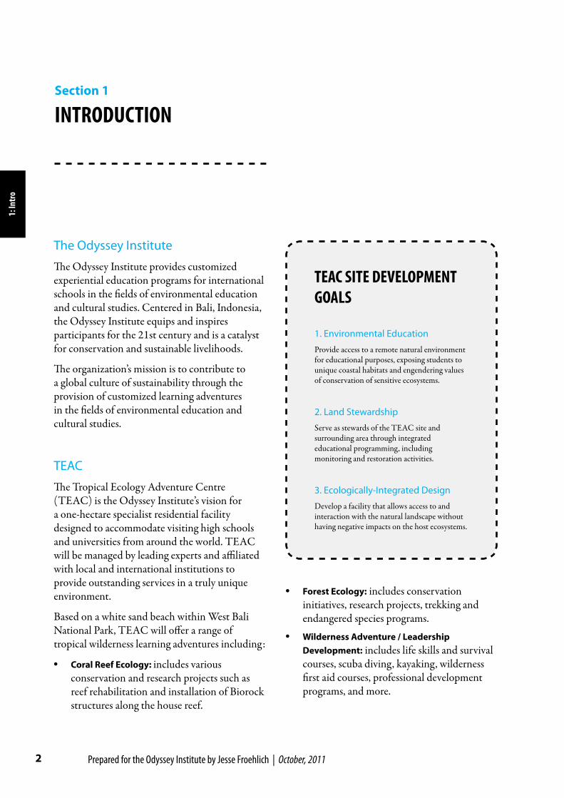
TEAC SITE DEVELOPMENT GOALS
1. Environmental Education
Provide access to a remote natural environment for educational purposes, exposing students to unique coastal habitats and engendering values of conservation of sensitive ecosystems.
2. Land Stewardship
Serve as stewards of the TEAC site and surrounding area through integrated educational programming, including monitoring and restoration activities.
3. Ecologically-Integrated Design
Develop a facility that allows access to and interaction with the natural landscape without having negative impacts on the host ecosystems.
1: In
tro
3 TEAC Ecological Development Guide
Development Goals
The development of the TEAC site will move forward for the purpose accomplishing the following goals:
1. Environmental EducationProvide access to a remote natural environment for educational purposes, exposing students to unique coastal habitats and engendering values of conservation of sensitive ecosystems.
2. Land StewardshipServe as stewards of the TEAC site and surrounding area through integrated educational programming, including monitoring and restoration activities.
3. Ecologically-Integrated DesignDevelop a facility that allows access to and interaction with the natural landscape without having negative impacts on the host ecosystems.
Accommodations & Infrastructure
TEAC will host residential programs for groups of up to 50 students at a time. The Odyssey Institute will install several semi-permanent, multi-purpose structures. These will be used as:
Dormitories for students•
Staff and teachers’ quarters•
Showers and toilets•
Laboratories (for field-based science •experiments)
Multi-purpose meeting rooms capable of •functioning as dining space, presentation venue, IT suite and library, etc
Shade areas•
Campfire•
Traditional Balinese temple and multicultural •sacred space
Basic medical / First Aid station •
Safety lookouts•
Storage space•
Waste collection including recycling and •compost
Dock•
Future site development may include
Treehouse bird-watch stations•
Aviary•
Turtle hatchery•
Elevated mangrove walk•
Floating platforms (rafts) for research, safety •and recreation
1: Intro

4 Prepared for the Odyssey Institute by Jesse Froehlich | October, 2011
Context
Bali is one of 33 Indonesian provinces, and is subdivided into eight administrative districts or regencies. While the 19,000 ha West Bali National Park encompasses parts of Jembrana and Buleleng Regency land areas, the National Park is under jurisdiction of the Indonesian National Ministry of Forestry, and generally not subject to local law.
The National Park’s 19,000 ha includes approximately 15,585 ha of continental land and 3,415 ha of territorial waters. The Park is subdivided into four zones including a core zone, a jungle zone, and cultural and intensive utilization zones (see Zone Map, Appendix C).
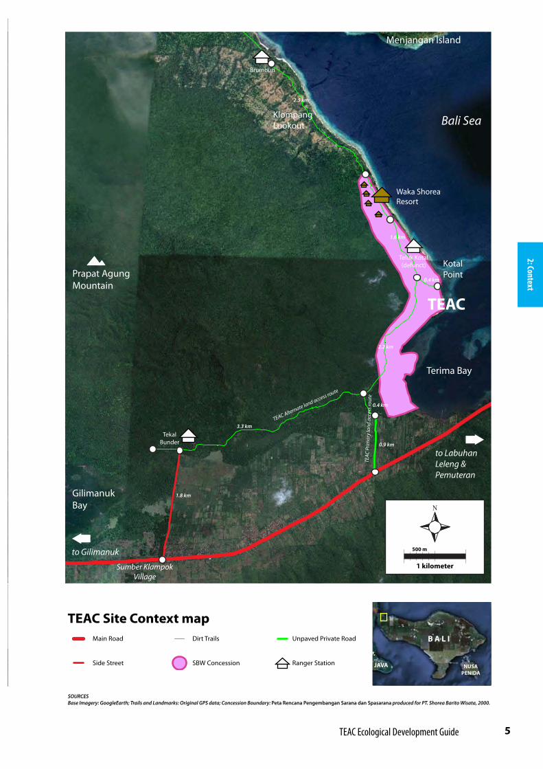
Odyssey Institute’s proposed TEAC site is located at 8.14°S Latitude and 114.52°E Longitude, on Pasir Putih (White Sand) Beach at Kotal Point. Kotal Point is a subtle promontory on the east side of Prapat Agung Peninsula at the National Park’s (and the Island of Bali’s) northwestern extent. The proposed site lies within a 251.5 ha private concession owned by PT. Shorea Barito Wisata (SBW) in the Buleleng Regency land area within the ‘utilization zone’ of West Bali National Park.
Access
Prapat Agung Peninsula is largely undeveloped, with the exception of SBW’s Waka Shorea Resort, located approximately two kilometers north of the proposed TEAC site. The National Ministry of Forestry also has six ranger stations skirting the peninsula, one of which, although defunct, is located within the SBW Concession boundary. There are no roads on the peninsula, and primary access for tourists is by boat, with frequent trips between the resort and Labuhan Lalang across Terima Bay. There is also a network of dirt trails that skirts the peninsula, used almost exclusively by Waka Shorea Resort staff and National Park rangers.
Buleleng District
Jembrana District
WEST BALINATIONAL PARK
Bali
Pro
vinc
e
East
Jav
a P
rovi
nce
TEAC
BALI
NUSAPENIDA
JAVA
Prapat Agung Peninsula
Bali Pr
ovin
ceW
est N
usa
Tenggara
P.
REGIONAL CONTEXTSection 2
2: Co
ntex
t
5 TEAC Ecological Development Guide
Menjangan Island
Terima Bay
to Labuhan Leleng & Pemuteran
to Gilimanuk
TEAC
Prim
ary
land
acc
ess r
oute
TEAC Alternate land access route
Waka Shorea Resort
Brumbun
TEAC
Kotal Point
Teluk Kotal(defunct)
Tekal Bunder
Prapat AgungMountain
KlompangLookout
2.2 km
0.4 km
1.6 km
2.5 km
0.4 km
0.9 km
3.3 km
1.8 km
Bali Sea
GilimanukBay
Sumber KlampokVillage
SOURCESBase Imagery: GoogleEarth; Trails and Landmarks: Original GPS data; Concession Boundary: Peta Rencana Pengembangan Sarana dan Spasarana produced for PT. Shorea Barito Wisata, 2000.
TEAC Site Context map Main Road Dirt Trails Unpaved Private Road
Side Street SBW Concession Ranger Station
1 kilometer
500 m
B A L I
NUSAPENIDA
JAVA
2: Context

6 Prepared for the Odyssey Institute by Jesse Froehlich | October, 2011
tradition, the most appropriate location for a temple will be the southern (kaja or ‘mountain-ward’) extent of the site.
Though the shape of the site is irregular in either case, approximate dimensions of both boundary
alternatives are 75 m x 110 m surrounding the sandy clearing, with a total of 290 m of total
beach frontage. The narrowest sections of both alternatives are 5 m wide.
Proposed Site Boundaries
The TEAC site boundary will encompass one hectare at Kotal Point. Two alternative site boundaries are proposed on the following page, each allowing for different site design layouts (see design concepts, Section 6).
In either case, the site begins at the high watermark on the coastline and extends westward approximately 75 meters to encompass a cleared sandy area. The site transitions into mangrove forest near its western and southern boundaries. Both site boundary alternatives include a narrow stretch of beachfront that extends southward to envelop an appropriate area for dock access, avoiding the center of the sensitive coral reef that extends into the ocean from Kotal Point. In keeping with Balinese
Seagrass Bed Coral Reef
Coastal Mangrove Patch
BeachMangrove
Forest
Waterline
3: Si
te
SITE BOUNDARIES & CHARACTERISTICS
Section 3
KAJA & KELODBalinese temples are built to a mountain-sea orientation. The mountainward direction, kaja, faces Mt. Agung in northeastern Bali and is considered the holiest direction.
Throughout most of Bali, kaja is to the northeast, but because the proposed TEAC site is north of Bali’s mountain range, in this case kaja is southeast.
Temple entrances are located at kelod, or the seaward side.
W E
Not to Scale

7 TEAC Ecological Development Guide
3: Site
Coral Reef[light blue]
Deep Sea
Mangrove Forest
[dark green]
Monsoon Forest
[light green]
Seagrass[darker patches]
TEAC Site BoundaryALTERNATIVE 2
ProposedDock Location
‘Kaja’ TempleLocation
Lookout Station
Shade Structure
Shower Bloc
Shower Bloc
Water Tank
ALT 2 WithExisting Infrastructure
SCALE50 m
100 m
SandyClearing
50 m
100 m
Coral Reef[light blue]
Deep Sea
Mangrove Forest
[dark green]
Monsoon Forest
[light green]
Seagrass[darker patches]
TEAC Site BoundaryALTERNATIVE 1
ProposedDock Location
‘Kaja’ TempleLocation
SandyClearing
Lookout Station
Shade Structure
Shower Bloc
Shower Bloc
Water Tank
ALT 1 WithExisting Infrastructure
SCALE50 m
100 m
50 m
100 m
TOTAL ENCLOSED AREA = 1 HA
TOTAL ENCLOSED AREA = 1 HA

8 Prepared for the Odyssey Institute by Jesse Froehlich | October, 2011
All infrastructure development will be confined to the one-hectare TEAC site boundary, but stewardship, exploration, and educational programming will extend to the areas beyond the site. Coordination with National Park authorities will be required for activities that take place outside of the SBW concession boundary.
Site Characteristics & Existing Conditions
An east/west crossection through the broad portion of the site and extending into the ocean, reveals four clear coastal ecosystem transects: mangrove forest, beach, seagrass beds, and coral reefs (see diagram, p. 6). A few coastal mangrove trees dot the coastline at the northern and southern ends of the proposed site.
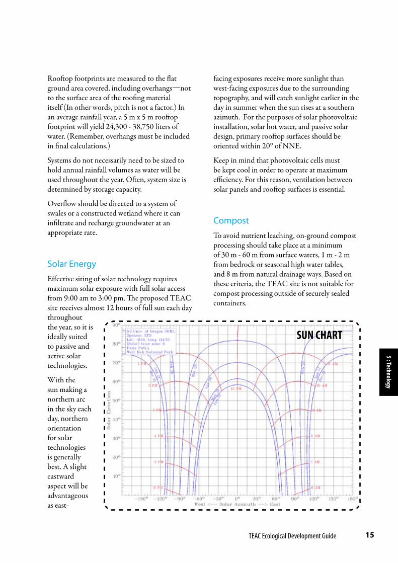
SunTemperatures in the National Park range from 20 - 33° C, with daytime temperatures typically hovering around 30°C. As the site is so close to the equator, there is little variation in temperature and day length throughout the year. The difference between the shortest and longest days of the year is just under one hour, with the sun rising and setting at 6:01am and 6:37 pm, respectively, on the summer solstice and at 6:33 am and 6:12 pm on the winter solstice. The sun generally makes a northern arc in the sky, although at the summer solstice, with the largest solar sweep, the sun rises and sets in a southern azimuth at 114° from north, rising to a noontime (maximum) elevation of 75° degrees. The winter solstice sun rises and sets at 66° from north, with noontime solar elevation of 58° degrees. The maximum annual solar elevation of 87° is reached in February (see Sun Chart, p. 15).
Wind & PrecipitationThe National Park sees average annual rainfall of 972-1,550 mm. The region is characterized by marked wet and dry seasons. During the dry season, which extends from May to October, prevailing winds come from the southwest, and are quite strong at Pasir Putih, especially on the southern face of Kotal Point. In fact, the shape of the reefs at Kotal Point and in Terima Bay point out the prevailing wind direction as coral reefs are largely shaped by the wind. According to Waka Shorea staff, August is the windiest month of the year.
3: Si
te
SECTOR COMPASSThis diagram illustrates directioal influences at Pasir Putih. The sector compass can be overlaid onto any aerial image of the site, centered at the point of concern, to determine the direction of influence. The solar elevations in the upper-right quadrant of the diagram are to be overlaid onto vertical elevation diagrams to reveal shadow lengths.
Sunrise, Jun 2166°E | 6:33 am
Sunrise, Dec 21114°E | 6:01 am
Sunset, Dec 21114°W | 6:37 pm
Sunset, Jun 2166°E | 6:12 pm
Jun 21, 8am & 4pm | 23°
Feb 2
1, no
on | 8
7°De
c 21,
noon
| 75°
Dec 21, 8am & 4pm| 31°Jun 21
, noo
n | 58
°
Select Solar Elevations:
Prevailing Dry Winds (May - October)
WINTER SUN
TERR
ESTR
IAL
WIL
DLI
FE
SUM
MER
SUN
N

9 TEAC Ecological Development Guide
Winds generally change direction in December, bringing wet weather from the northeast. December through February is noted as the rainiest time of year. The monsoon season is also dubbed ‘trash season’ by the staff at the Waka Shorea Resort, as the wind sweeping across the sea brings much plastic and other waste to wash up on the eastern shores of the Prapat Agung Peninsula. At the same time, monsoon rains fill the inland waterways and convey garbage that has collected in the creek beds throughout the dry season, for an overall effect of upwelling trash at the shorelines.
WildlifeTerrestrial wildlife is prevalent in the peninsula’s monsoon forest, and even in the coastal mangrove forest as animals are drawn towards the coast, particularly during the dry season, in search of water. Apart from the 160 bird species present in the Park (most notably the Bali Starling, whose protection was one of the primary reasons the Park was established in 1941), visitors will often see barking deer, miniature rusa or mouse deer, long-tailed macaques, ebony leaf monkeys, wild boar, giant water monitor lizards, civets, flying fox bats, and wild partridges. The named terrestrial species have all been observed in the area immediately surrounding the proposed TEAC site. Banteng (wild bull; another primary reason for the Park’s establishment), pythons and leopard cats are also present in the National Park. (See Wildlife Distribution Map, Appendix C). Marine species are abundant in the beach ecosystems, lagoons, coral reefs, and deep waters of the National Park, with highest biodiversity of fish observed amongst the reefs. Hawksbill turtles, pilot whales, dolphins, and many species of reef fish have been observed in the reef at Kotal Point.
Slopes & DrainageWaterflow through the proposed TEAC site trends primarily from west to east as the
mountainous topography of the peninsula drops down towards the coastline. Seasonal high water tables, however, bring inland lagoons in areas just west and south of the site, as indicated by the low-lying mangrove forests surrounding the site. The TEAC site itself, however—within the recommended boundaries—is elevated enough to stay dry. As the primary cleared area of the site is on higher ground than the surrounding lagoons, drainage patterns on the site will see some water flowing to the south and west in addition to the larger eastward drainage pattern.
There is one defunct well just north of the proposed site, although groundwater in the area is saline. This may indicate that saltwater intrusion has occurred in the area as is a reported concern in the more heavily traveled tourist hubs in southern Bali.1
Existing InfrastructureCurrently, water is pumped and piped onto the peninsula from the nearby village of Sumber Klampok. Water is delivered to the Waka Sorea Resort, and from there, gravity fed to a 5,000 liter water tank at Pasir Putih.
Additionally at Pasir Putih, two temporary shower/toilet blocs have been installed (6.5 m x 1.8 m each), as well as one shade structure (9 m x 3 m), and one small shaded lookout station facing the ocean (1.7 m x 1.7 m).
1 Saltwater intrusion is movement of saline water into freshwater aquifers. Intrusion can occur by natural forces such as storm surges, but it often occurs when groundwater sources in coastal areas are drawn upon too heavily. This causes a pressure differential and subsequent influx of saltwater into the aquifer, rendering the groundwater undrinkable and unfit for irrigation.
3: Site

10 Prepared for the Odyssey Institute by Jesse Froehlich | October, 2011
Why Develop this Site?
Every element of an ecosystem is both a product of and a contributor to that ecosystem. To alter an ecosystem’s composition will have unintended consequences to its unique matrix of interrelated processes.
A site-sensitive design will have minimal impacts on the host ecosystems, allowing program participants to experience and steward these landscapes while living in balance with ecosystem functions.
Pasir Putih at Kotal Point has been identified as an ideal site for TEAC because:
It is important for people to be exposed to •these sensitive ecosystems to build awareness of the necessity to conserve them.
Such centers of biodiversity are ideally •suited for environmental education. New educational models center around the importance of ecosystem function for overall global health and resilience.
Visitors to the site can serve as monitors and •stewards.
Development can be approached in a low-•impact way.
Site Development Recommendations
The following recommendations are organized under the ecosystem consideration which they serve.
Because coral reefs are highly sensitive and weakened by fresh water runoff and sedimentation:
Elevate structures on posts to minimize •ground contact and maintain natural drainage patterns and infiltration levels.
Elevated structures also allow for greater •ventilation and create more storage opportunities.
Taller structures create more shade on •the site and, if sited appropriately, can maximise rooftop solar exposure.
For any structures that require significant •ground contact, orient structure on a diagonal to natural waterflow at that location (east-west on most of the TEAC site). This will minimize obstruction to natural drainage patterns.
Avoid bringing in fill from other sites as it •can alter the microbiology of the substrate and increase the risk of sedimentation in the reef.
Avoid ground compaction so that infiltration •levels are preserved and freshwater runoff is not increased.
Designate clear pathways for human •circulation and allow natural beach vegetation to grow in between. Beach vegetation stabilizes the sand, protects against erosion, and provides habitat value for native wildlife.
Pathways can be elevated;•
DEVELOPMENT PRINCIPLES & RECOMMENDATIONS
Section 4
4: R
ecs

11 TEAC Ecological Development Guide
Separate organic waste, including paper, to •be composted. Manage compost actively as an educational opportunity for students. 2
Because nitrification is a threat to coastal ecosystems:3
Use compost off-site (transport it to the •mainland);
OR
Use on-site only in secure raised beds to •ensure that organic matter not be conveyed to the delicate costal ecosystems.
Because wildlife need to be respected and not domesticated or rendered pests by human activity:often obfuscate the true destination of products bound for the ‘recycling center.’ 2 All recommendations related to compost apply both to ‘humanure’ and kitchen waste, which should be composted separately. 3 With the Gulf of Mexico in the United States as an example, when organic residue runs off into the sea as a result of unsustainable agricultural and waste management practices, nitrification occurs which leads to algal blooms that rob the ecosystem of sunlight and oxygen, eventually creating “dead zones” in the water.
WHY DEVELOP THIS SITE?Pasir Putih at Kotal Point has been identified as an ideal site for TEAC because:
It is important for people to be exposed •to these sensitive ecosystems to build awareness of the necessity to conserve them.
Such centers of biodiversity are ideally •suited for environmental education. New educational models center around the importance of ecosystem function for overall global health and resilience.
Visitors to the site can serve as monitors •and stewards.
Development can be approached in a •low-impact way.
4: Recs
OR
Delineated on the ground with natural •materials found on-site, such as dead coral and driftwood (see photos, p. 13).
Catch, store, and use rooftop rainwater to •avoid freshwater sheeting effects close to the shoreline (see Technology Briefs, p. 14).
This will also minimize reliance on water •pumped in from off-site.
Infiltrate greywater and stormwater overflow •slowly (through a system of swales, wetlands, and/or drip release).
Because the sand itself embodies a 3-dimensional habitat structure:
Avoid bringing sand in from other sites.•
Sand mineral makeup and grain size are •specific to location.
Sand from off-site may run off and create •sedimentation in the reef.
Sand from off-site can obstruct •movement and nutrient flow for beach ecosystem life forms.
Because material waste (litter) is a uniquely human input and a detriment to most ecosystems and wildlife:
Minimize the amount of material waste •produced on-site, particularly items that cannot be reused or composted.
Collect all waste in sealed containers so that •it cannot be carried away by the wind or wildlife.
Separate materials that can be recycled •and ensure their delivery to an appropriate processing center. However, do not consider recycling to be an equal alternative to re-use or composting.1
1 Recycling, though preferable to landfilling or incineration, is highly energy-intensive and for many materials, quality is downgraded in the process. Policy and economic realities

12 Prepared for the Odyssey Institute by Jesse Froehlich | October, 2011
4: R
ecs
Compost should be processed in closed, •animal-proof tanks (available commercially).
Consider directing greywater and stormwater •overflow to drinking pools for wildlife. Construct pools within or at the edge of the monsoon forest habitat to avoid domestication of wildlife and pestilence issues.
Because marine life like vertical and three-dimensional habitats:
Build dock on posts rather than installing a •floating dock. This will also:
Limit the amount of surface area contact •of dock material to water.
Minimize temperature change to sea •water.
Provide more stable means of getting •people and cargo onto the site.
Because careful building siting and orientation can significantly increase a building’s comfort level and energy efficiency, and decrease its impact on the environment:
Orient buildings for maximum ventilation. •Prevailing winds during the dry season come from the southwest. Allow wall panels to open to the breeze and/or install floor vents in elevated structures. Cooler air will enter through floor vents as warmer air is released through ceiling vents.
For consideration of solar photovoltaic •installation, east-facing exposures will receive more sunlight than west-facing exposures due to the surrounding topography. As the sun primarily makes a northern arc in the sky, northeastern orientation for solar panels will receive the greatest solar exposure. (see Technology Briefs, p. 15).
Arranging structures in an arc covering the •northeastern aspect of the site will create maximum shade in the sandy clearing.
Because the moon plays an important role in tidal ecology:
Identify a “moon camp” (stargazing, too!) •outside of the one-hectare building zone for night hikes and overnight campouts (no permanent structures here!)

13 TEAC Ecological Development Guide
Waka Shorea Resort
Ceiling vents and floor vents work together to keep buildings cool
Rooftop rainwater is caught and collected in barrels
Vegetated swales process water that sheets off of structures and provides habitat for beach critters
Structures built on raised platforms mini-mize obstruction to natural drainage and wildlife flows
Foot-rinse stations utilize harvested rainwater and keep indoor areas clean
Elevated windbreak protects building while allowing ventilation to come underneath
4: Recs
CONCEPT SKETCH(not to scale)
CORAL-LINED PATHWAYS
Waka Shorea Resort

14 Prepared for the Odyssey Institute by Jesse Froehlich | October, 2011
Rainwater Catchment
Rainwater is some of the purest water available. Free from pollutants that can leach into surface waters and groundwater—and devoid of the treatment chemicals that are added to district administered water—rainwater caught from rooftops is suitable for many uses, including landscape irrigation, appliance use, washing, and bathing.
Catchment systems are easy to build and provide a free source of clean water that would otherwise
be delivered as runoff to waterways, collecting sediments and contaminants on its way. Runoff mitigation is particularly important at the TEAC site because of the sensitive coral reefs that lie immediately to the east.
Each millimeter of rain falling on one square meter of rooftop footprint area will yield one liter of water. With average rainfall levels of 972-1,550 mm annually in the National Park, expect 972 - 1,550 liters of water per square meter of rooftop footprint per year.
5 : Te
chno
logy
TECHNOLOGY BRIEFSSection 5
ANATOMY OF A RAINWATER CATCHMENT SYSTEM
VENT
Rainwater catchment systems must be vented to ensure proper flow of water. The large pipe along the top of this system allows for sufficient ventilation. Alternatively, the top pipe could be eschewed, allowing all water to flow into the first barrel (as all barrels are plumbed together along the bottom, they all fill from the bottom at the same rate). In this case, each barrel would require a small vent hole in the top. Vents can be covered with mesh to avoid clogging and insects.
FIRST FLUSH
In the system depicted here, leaves and other rooftop debris fall into this “first flush” pipe so that they don’t clog the system. Only when the first-flush pipe fills does clean rainwater spill over into the storage tanks. A cap at the end of the first-flush pipe can be removed between rains to empty any debris that was caught. Alternatively, a screen filter can be placed in the downspout to keep debris out of a water catch-ment system.
OVERFLOW
All rainwater catch-ment systems need an overflow outlet. Direct the rainwater overflow to a landscaped swale or wetland.
OUTLET & FLOW
A 2% grade ensures directional flow of water. In this system, the bottom pipe slopes at 2% towards the outlet spigot. Gutters must also slope at 2% in the direction of the downspout.
Indian Valley Organic Farm & Garden, Novato, CA, USA
15 TEAC Ecological Development Guide
5 : Technology
Rooftop footprints are measured to the flat ground area covered, including overhangs—not to the surface area of the roofing material itself (In other words, pitch is not a factor.) In an average rainfall year, a 5 m x 5 m rooftop footprint will yield 24,300 - 38,750 liters of water. (Remember, overhangs must be included in final calculations.)
Systems do not necessarily need to be sized to hold annual rainfall volumes as water will be used throughout the year. Often, system size is determined by storage capacity.
Overflow should be directed to a system of swales or a constructed wetland where it can infiltrate and recharge groundwater at an appropriate rate.
Solar Energy
Effective siting of solar technology requires maximum solar exposure with full solar access from 9:00 am to 3:00 pm. The proposed TEAC site receives almost 12 hours of full sun each day throughout the year, so it is ideally suited to passive and active solar technologies.
With the sun making a northern arc in the sky each day, northern orientation for solar technologies is generally best. A slight eastward aspect will be advantageous as east-
facing exposures receive more sunlight than west-facing exposures due to the surrounding topography, and will catch sunlight earlier in the day in summer when the sun rises at a southern azimuth. For the purposes of solar photovoltaic installation, solar hot water, and passive solar design, primary rooftop surfaces should be oriented within 20° of NNE.
Keep in mind that photovoltaic cells must be kept cool in order to operate at maximum efficiency. For this reason, ventilation between solar panels and rooftop surfaces is essential.
Compost
To avoid nutrient leaching, on-ground compost processing should take place at a minimum of 30 m - 60 m from surface waters, 1 m - 2 m from bedrock or seasonal high water tables, and 8 m from natural drainage ways. Based on these criteria, the TEAC site is not suitable for compost processing outside of securely sealed containers.
SUN CHART
16 Prepared for the Odyssey Institute by Jesse Froehlich | October, 2011
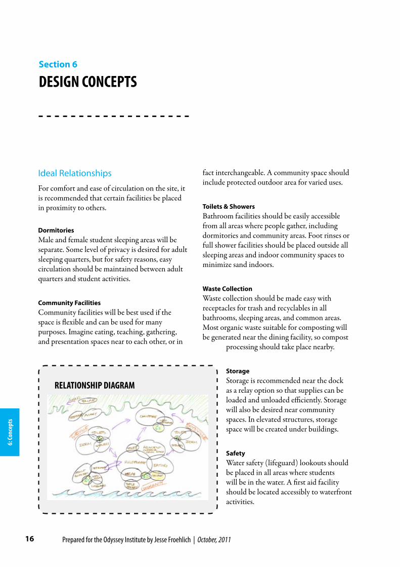
Ideal Relationships
For comfort and ease of circulation on the site, it is recommended that certain facilities be placed in proximity to others.
DormitoriesMale and female student sleeping areas will be separate. Some level of privacy is desired for adult sleeping quarters, but for safety reasons, easy circulation should be maintained between adult quarters and student activities.
Community FacilitiesCommunity facilities will be best used if the space is flexible and can be used for many purposes. Imagine eating, teaching, gathering, and presentation spaces near to each other, or in
6: Co
ncep
ts
DESIGN CONCEPTSSection 6
fact interchangeable. A community space should include protected outdoor area for varied uses.
Toilets & ShowersBathroom facilities should be easily accessible from all areas where people gather, including dormitories and community areas. Foot rinses or full shower facilities should be placed outside all sleeping areas and indoor community spaces to minimize sand indoors.
Waste CollectionWaste collection should be made easy with receptacles for trash and recyclables in all bathrooms, sleeping areas, and common areas. Most organic waste suitable for composting will be generated near the dining facility, so compost
processing should take place nearby.
StorageStorage is recommended near the dock as a relay option so that supplies can be loaded and unloaded efficiently. Storage will also be desired near community spaces. In elevated structures, storage space will be created under buildings.
SafetyWater safety (lifeguard) lookouts should be placed in all areas where students will be in the water. A first aid facility should be located accessibly to waterfront activities.
RELATIONSHIP DIAGRAM

17 TEAC Ecological Development Guide
Site Boundary
Foot Path
Student Sleeping Zone
Adult Sleeping Zone
Indoor Community Space
Outdoor Community Space
Medical/Safety Facility
Building
Bathroom
Med Room
CONCEPT 1: Community Central
6: Concepts
Three Design Concept Alternatives
The three concepts diagramed here are shown in greater detail on the following pages.
LEGEND
CONCEPT 2: Wooded Village CONCEPT 3: Phased Flex

18 Prepared for the Odyssey Institute by Jesse Froehlich | October, 2011
SCALE5m
10m
6: Co
ncep
ts
Concept 1: Community Central
CONCEPT 1 FEATURES
BOUNDARIES: Uses proposed site •boundary Alt.1.
STUDENT DORMITORIES:Small residential •‘villages’ at north and south ends of site allow for a sense of retreating at the end of an active day.
Sleeping areas are in wooded alcoves, well •protected from the wind.
Boys and girls sleeping areas are separated by •community facilities at the center of the site.
ADULT SLEEPING QUARTERS: Adult quarters are placed in proximity to •student dormitories but still relatively private.
COMMUNITY FACILITIES: Expansive ocean views from community •facilities.
Windbreak for the primary community •building defines an adjacent outdoor community space, shaded by the building itself.
Primary community building’s NE •orientation provides optimum opportunity for rooftop solar installations.
Much of sandy clearing is left open for •circulation.
BATHROOMS: Utilizes existing toilet/shower bloc facilities.•
Water tank can stay in place.•
Existing Lookout
AdultQuarters
AdultQuarters
Multi-UseCommunity
Space
StudentVillage I
StudentVillage II

19 TEAC Ecological Development Guide
6: Concepts
Concept 2 : Wooded Village
CONCEPT 2 FEATURES
BOUNDARIES: Uses proposed site •boundary Alt. 2.
STUDENT DORMITORIES:Sleeping areas are •concentrated into small village clusters in the woods.
Wooded alcoves protect village clusters from •the wind.
ADULT SLEEPING QUARTERS: Adult quarters are clustered around a central •bathroom.
Adults village is separate from student •villages, but situated nearby.
COMMUNITY FACILITIES: Indoor and outdoor community spaces are •concentrated in the sandy clearing to the north of the residential villages.
Windbreak for the primary community •
building defines an adjacent outdoor community space, and separates community space from residential villages.
Primary community building’s NE •orientation provides optimum opportunity for rooftop solar installations.
Lookouts are placed at north and south ends •of the primary beach area.
BATHROOMS: Each building cluster includes a bathroom •facility.
Village I utilizes existing toilet/shower bloc.•
SCALE5m
10m
LookoutStation
AdultVillage
Multi-UseCommunity
Space
LookoutStation
StudentVillage I
StudentVillage II

20 Prepared for the Odyssey Institute by Jesse Froehlich | October, 2011
6: Co
ncep
ts
Concept 3: Phased Flex
CONCEPT 3 FEATURES
BOUNDARIES: Uses proposed site •boundary Alt. 2
STUDENT DORMITORIES:Dormitory buildings •for students are centrally located.
Spacious dorms •provide flexible space that can be used for community activities before other facilities are built in a phased development plan.
ADULT SLEEPING QUARTERS: Adult quarters are very private with good •ocean views.
Adults stationed at northern and southern •ends of the built area provides a sense of security.
COMMUNITY FACILITIES: Because dormitory space is flexible, •community facilities can be built as part of a
later phase of development.
In later phases of development, specialty •activity clusters utilize the smaller clearings in the site, creating more of a ‘campus’ feel.
Much of the sandy clearing is left open for •circulation.
BATHROOMS: Each sleeping area has its own toilet/shower •facilities.
Bathrooms are planned in community areas •as needed.
SCALE5m
10m
AdultQuarters(phase I)
Multi-UseCommunity
Space(phase II)
FlexDormitory I
(phase I)
AdultQuarters(phase I)
FlexDormitory II
(phase I)
SpecialtyActivity Cluster
(phase III)
SpecialtyActivity Cluster
(phase III)

21 TEAC Ecological Development Guide
Curriculum Briefs
The following curriculum briefs go hand-in-hand with the development recommendations so that facility and program can serve the environment in an integrated way. These ideas can be fleshed out to complement other Odyssey Institute curriculum, helping to ensure that students internalize the specific needs of the delicate ecosystems they inhabit.
First, identify a ‘Stewardship Zone’ that extends beyond the one-hectare lease. Have students carry out monitoring activities within this zone.
Wildlife & Ecosystem MonitoringStudents monitor the coral reef at Pasir Putih over time and link environmental influences to observed effects. Students can also compare reefs at Kotal Point with Waka Shorea and Menjangan Island reefs.
Coral Reef RestorationStudents place artificial reefs (three-dimensional habitats) in responsible locations (see notes on coral reefs, Appendix A) and study life forms over time. Are there any differences in the wildlife observed in the artificial and natural reefs?
Habitat ObservationStudents record detailed observations about wildlife and the conditions in the places they are spotted on a map of the TEAC site and stewardship zone. What elements make up a
INTEGRATED CURRICULUMSection 7
7: Curriculum
habitat? Is it obvious why animals are spotted in particular locations? Is there anything we can do to protect or enhance habitat features for these animals?
Waste Forensic AmbassadorsBecause litter and sedimentation are two primary causes for coral reef degradation, a litter abatement program can go a long way at TEAC. Students pick up litter within the stewardship area, classify it (glass, plastic, etc…) and do some forensics to try and figure out where it is coming from. (In ecological terms, what are the ‘sources’ that lead to the ‘garbage sink’ at Kotal Point?) Weigh the findings (keep stats!) and dispose of them properly. Notice seasonal patterns as well. The rainy season is also known as “garbage season” amongst locals because the NE winds bring trash in on the ocean’s great conveyer belt! What can we do here at TEAC to make sure our own wastes are managed? Remember, with winds changing direction mid-year, our trash gets blown out to sea for 6 months of the year.
Coastal Web of LifePost TERANGI’s (Indonesian Coral Reef Foundation’s) “Coastal Ecosystem” Poster at TEAC, and teach from it! (See example posted at Waka Shorea guest office.) The poster provides a segue into a “web of life” discussion. Sea turtles eat seagrass, which protects coral reefs, which provide habitat for fish. While seagrass provides food for sea turtles, sea turtles help seagrasses spread their seeds in a symbiotic

22 Prepared for the Odyssey Institute by Jesse Froehlich | October, 2011
relationship. What happens when you knock out any piece in this chain? Is any one element more important to the whole system than another? What is our place in this chain as human beings? Students can develop a detailed web-of-life diagram specific to TEAC’s ecosystem.
7: Cu
rricu
lum

23 TEAC Ecological Development Guide
APPENDICES
Appendix A: Concise Notes from The Ecology of Java and Bali
Appendix B: Code of Behavior for Visitors to Coral Reef Areas in West Bali National Park
Appendix C: Area Maps
Appendix D: Photo Gallery

24 Appendix A: Concise Notes from The Ecology of Java and Bali
These notes were taken by Jesse Froehlich from ‘The Ecology of Java and Bali’ by Tony Whitten, Roehayat Emon Soeriaatmadja, and Suraya A. Afiff, from The Ecology of Indonesia Series, Vol. II, Periplus Editions (HK) Ltd., 1996.
CORAL REEFS (pp. 345-367)
Ecosystem Services:
Prevent coastal erosion•
Support tremendous biodiversity of species•
High levels of nutrient cycling•
Coral reefs are made of compacted skeletons and the skeletal sediment of sedentary organisms, smothered by other organisms. The outermost layer is made of living tissue (invertebrates).
They form in water that’s above 22°C (61-62°F), and is clear and illuminated, with normal salinity.
Types:
• Fringing:closetoshoreandrockyshorelines
• Barrier:wherecoasthassubsided,growingseawardformingalagoononshore
• Patch:isolatedpatchesofsubstrate,notexposedabovesealevel
Coral reef studies were conducted in West Bali National Park in the 1980s (347-8).
The direction of prevailing winds shapes compositions of coral reefs (348).
Corals mature in 3 – 8 years, growing at 1 – 10 mm/year radially.
CONCISE NOTES FROM THE ECOLOGY OF JAVA AND BALI
Appendix A

25 Appendix A: Concise Notes from The Ecology of Java and Bali
Most secrete gametes at night, simultaneously, a few days after the full moon. Simultaneous breeding increases the chances of egg meeting sperm, and reduces the chances of another animal specializing on eggs as food.
Coral reefs are highly sensitive, weakened by fresh water runoff and sedimentation.
Reefs are highly biodiverse—themselves, living—acting as hosts to many other species. There is a greater density of fish on reefs than any other area of the sea, at 100 – 200 species per hectare (352). Reefs are 20 times more productive than open sea (355). About 75% of reef biomass is plant material (355). Tons of nutrient recycling happens here.
Sea life likes reefs (and shipwrecks, for that matter!) because they provide 3-D habitat for life succession to establish itself (358).
West Bali National Park has terrestrial conservation areas that include significant stretches of reef within existing (or proposed) boundaries (360).
Reefs are threatened by coral mining, fish bombing, pollution, sedimentation, and tourism. (362)
Sedimentation is the most insidious cause of damage to coral reefs. All development plans must include thought to sources of sedimentation (364).
GUIDELINES FOR BUILDING ARTIFICIAL REEFS: “Successful artificial reefs are deliberately constructed to provide appropriate habitat for target species—they are not just dumped in the sea to fall scattered on the seabed. The placement of artificial reefs is also extremely important if they are to result in an overall increase in harvestible productivity; a study in the Philippines, for example, has found that they must be at least 1 km away from natural reefs, near an alternative food source (e.g., seagrass beds), on flat or gently sloping sand in water with good visibility at depths of 15-25 m, protected from excessive wave action, and accessible to fishermen (White et al. 1990) (358-9).
SEAGRASS MEADOWS (pp. 378-372)
Ecosystem Services:
Bind shallow sediments against erosion, thus protecting neighboring coral reefs•
Provide habitat for unique species including food source for sea turtles•
Grow in shallow lagoons. Species change as depth cnages, in transects.
10 species belonging to two families are present in Java and Bali.

26 Appendix A: Concise Notes from The Ecology of Java and Bali
One of the very few “higher plant species” that thrives entirely in seawater. Many pollinate underwaer.
Seed is dispersal is close-range, but the range expands when dugongs and sea turtles eat/defecate them. Unfortunately, dugong has been hnted to extinction around Java and Bali, and sea turtles are becoming more and more rare (368).
Much of seagrass’ nutrient value enters the food chain after it dies as the decomposition process breaks down the cellulose and renders it digestible to many more organisms.
Many fish find safe habitat in seagrass which generally doesn’t support larger predatory species.
Biodiversity of seagrass rather than quantity / biomass determines fish abundance.
Symbiotic with coral: coral protects the lagoon (seagrass habitat); seagrass traps sediments, reducing turbidity.
BEACHES (pp. 372-385)
Lots of animals living in the beach sand, mostly infauna, but some epifauna as well.
Burrow holes help to aerate the sand to greater depths.
Some creatures feed on sediments and then defecate them, increasing organic content of the sand.
Terrestrial animals frequent beaches to meet their need for salt.
Common sea bird species that roost in the National Prk are the brown booby (Sula leucogaster) and the great frigatebird (Fregata minor) (p. 383, table 7.3).
MANGROVE FORESTS (pp. 387-412)
Ecosystem Services:
Leaves deliver nutrients for inshore and estuarine ecosystems•
Nursery grounds for fish, shrimp, etc.•
Root systems protect from erosive wave energy•

27 Appendix A: Concise Notes from The Ecology of Java and Bali
Building timber•
Rayon production•
Other commercial uses although sustainable harvest is no longer possible•
Mangrove forests provide “nursery function for important fish and prawns, ecological support for coastal fisheries, ‘cheap’ protection of coastlines and a sorurce of wide-range forest produce” (409).
Rhizophora spp. are the best source of building timber. They have stilt roots and dagger-shaped fruit (387).
Under green belt legislation, must leave 50 m of mangroves between shore and development (388).
If lenticels on aerial roots are clogged (as in an oil spill), gas exchange will be prevented and trees will die.
Herbivores eat roughly 10% of mangrove leaves. The other 90% fall to the ground and are pulled into burrows within 3 weeks by crabs and then defecated, initiating a world of microbial/fungal action (see fig 8.10, p. 398). Resulting detritus is very important for the productivity of mangrove and adjacent ecosystems.
Crabs and snails are uniquely adapted to wet/dry fluctuations in mangrove forests. Thir own metabolisms contribute to the health of the system as well.
Like other ecosystems, mangrove forests, when fragmented by development, become more brittle (less resilient), lose biodiversity and are able to host fewer animal species. At the fragmented stage, insect attacks are more likely to threaten the trees (as observed near Medan, N. Sumatra) (406).

28 Appendix B: Code of Behavior for Visitors to Coral Reef Areas in West Bali National Park
This information was taken from Table 7.2, p. 361 of ‘The Ecology of Java and Bali’ by Tony Whitten, Roehayat Emon Soeriaatmadja, and Suraya A. Afiff, from The Ecology of Indonesia Series, Vol. II, Periplus Editions (HK) Ltd., 1996.
CODE OF BEHAVIOR FOR VISITORS
Visitors to coral areas are required to:
Follow this code of behavior the functions of which are to ensure maximum protection for the coral 1.reefs of the national park marine areas, and the safety and comfort of visitors to them.
Follow advice and instructions from the boatman and guide or guard on board.2.
Visitors to coral areas are not allowed to:
Fish for, trap, snare, move, remove from the water, or roughly handle or damage or kill any marine 3.life.
Damage, alter move, or remove any object or natural feature. 4.
Sit, stand, or rest on any living coral anywhere on the coral reef except in a life threatening situation.5.
Throw or discharge any rubbish of any sort into the sea within the national park marine protected 6.area boundaries.
Land or go ashore anywhere other than at a place designated fro landing and going ashore. 7.
CODE OF PRACTICE FOR BOATMEN
Boatmen are required to have:
A current recognized certificate of proficiency in Medical First Aid.1.
Boatmen are required to:
Ensure the safety and comfort of visitors in the coral areas and to identify and warn them of 2.common dangers (e.g., marine life that stings, bites, is poisonous or otherwise harmful or dangerous) and to advise them how to best avoid such contacts.
Have at least one other crewman on board on any visit to a coral area. 3.
CODE OF BEHAVIOR FOR VISITORS TO CORAL REEF AREAS IN WEST BALI NATIONAL PARK
Appendix B

29Appendix B: Code of Behavior for Visitors to Coral Reef Areas in West Bali National Park
Proceed at not more than 5 knots (8 kph), over any coral reef flat, reef front, reef terrace, drop-off, 4.and reef slope for at least 100 m seaward of the drop-off (the look-out zone).
Maintain, while moving in the look-out zone:5.
From the helm, special watch ahead and abeam (on both sides).a.
From the foredeck or not more than 3 m from the fair-lead, special watch ahead and abeam. b.
Ensure that no part of his boat contacts any part of the coral reef at any state of the tide, sea or wind 6.except in life, or vessel, threatening situations.
Never anchor on any living coral or allow his anchor or anchor wrap to come into contact with any 7.living coral or any other marine life.
Always use any mooring provided. 8.
When a mooring is not provided, anchoring must be carried out on sand using a proper sand anchor 9.so that no part of the anchor, chain, or wrap can contact any living coral or marine life at any state of the tide, sea, or wind.
As a last resort anchoring is permitted on dead coral areas, e.g., the reef flat, in such a way that no 10.part of the anchor, chain, or wrap contacts living coral or marine life.
Avoid discharge of any fuel, oil, bilge water, or rubbish in the look-out zone or anywhere in the 11.marine protected ares.
Warn passengers not to discharge any rubbish from the boat.12.
If there is no guard or guide on board, the boatman must inform his passengers of the status of the 13.coral area, of the codes of practise, and of their obligations.
Not allow any marine life, living or dead, or any object or natural feature of the marine protected 14.area to be brought on board his boat or conveyed by it.
Not allow any fishing or collecting gear to be carried on or used from his boat except with express 15.written permission from PHPA, or in an area where fishing or collecting is allowed.
Refrain from entering, or conveying visitors for the purpose of entering, any area that PHPA has 16.declared to be prohibited to divers or visitors.
Carry and display on board the boatmen’s and visitors’ code of practice. 17.

30 Appendix C: Area Maps
Contours = 25mTopography
AREA MAPSAppendix C

31 Appendix C: Area Maps
MAP:FACILITIESANDINFRASTRUCTUREDEVELOPMENTPLANBLOCKII-KOTALPOINTANNUALWORKPLAN
PERIOD1APRIL-31DECEMBER,2000NATURETOURISMCONCESSIONPT.SHOREABARITOWISATA
WITHINUTILIZATIONZONEOFWESTBALINATIONALPARKINDISTRICTADMINISTRATIONIIBULELENGANDJEMBRANA
T E R
I M A B
A Y
KOTAL POINT
T E R
I M
A
B A Y
INDEXMAP:IPPAWORKINGAREA
PERSPECTIVEMAP

32 Appendix C: Area Maps
Map of Development
Buffer Zones
West Bali National Park
Regional DevelopmentPejarakan Village, Excl.Gerokgak, Kab. Buleleng
Legend:
PERSPECTIVE MAP, BALI ISLAND
B A L I S E A
B A L I S T R A I T
PLANTATION
PLANTATION
B A L I S T R A I T
ZONE MAP
WEST BALI NATIONAL PARKDISTRICT REGION II BULELENG AND JEMBRANA
PROVINCE REGION I BALIAREA ± 19,002.89 HA
APPENDIX TO LETTER OF THE DIRECTOR GENERALFOREST PROTECTION AND NATURE CONSERVATION
DATE: 15 APRIL 1996 NO.38/Kpts/DJ-IV/1995
West Bali National Park Boundary
Regency Boundary
Main Road
Settlements/Villages
Triangulation Point
River
Enclave
Plantation
LEGEND
CORE ZONELand : 7,663.89 Ha Territorial Waters : 970.00 Ha
JUNGLE ZONELand : 6,281.00 HaTerritorial Waters : 515.00
UTILIZATION ZONELand : 1,613.00 HaMarine Waters : 1,960.00 Ha
PERSPECTIVE MAP, BALI ISLAND

33 Appendix C: Area Maps
RANGER STATION (or ‘WATCH-POST’)
MAIN ROAD
SEA AND RIVER BOUNDARIES (INCL. TRIBUTARY)
AREA/FUNCTION BOUNDARY
ENCLAVE (SUMBER KLAMPOK AND KLATAKAN VILLAGES)
RANGER STATION LOCATION MAPWEST BALI NATIONAL PARK
LEGEND
PERSPECTIVE MAP, BALI ISLAND
B A L I S E A
B A L I S T R A I T
M A PWILDLIFE DISTRIBUTION
WEST BALI NATIONAL PARK
Bali Starling Leaf Monkey
Banteng (Wild Bull) Long-Tailed Macaque
Mouse Deer Partridge
Barking Deer Kangkereng
Wild Boar Bat
MAIN ROAD
SEA AND RIVER BOUNDARIES (INCL. TRIBUTARY)
AREA/FUNCTION BOUNDARY
ENCLAVE (SUMBER KLAMPOK AND KLATAKAN VILLAGES)
LEGEND
PERSPECTIVE MAP, BALI ISLAND
B A L I S E A
B A L I S T R A I T

34 Appendix D: Photo Gallery
PHOTO GALLERYAppendix D
West North East South
Panorama from enter of Sandy Clearing
Approaching Pasir Putih from the north
Pasir Putih from Terima Bay Pasir Putih from Terima Bay
Pasir Putih from Terima Bay

35Appendix D: Photo Gallery
West North East South
Panorama from enter of Sandy Clearing
Mangroves at northern extent of proposed TEA C site Pneumatophore mangrove roots
Looking south along Pasir Putih, shade structures visible
Entering the sandy clearing, looking west
Looking south along Pasir Putih, low tide
Pocket at the southeast corner of the sandy clearing

36 Appendix D: Photo Gallery
Existing 5,000 L water tank
Existing shade structure
Existing shower and toilet bloc
Existing look-out shelter
Woody feature at south end of proposed site
Existing shower and toilet bloc Existing shower and toilet bloc
Natural bridge at northern end of proposed site

37Appendix D: Photo Gallery
Southern mangrove stand, low tide
Beach vegetation
Southern mangrove stand, high tide
‘Bird watch’ tree at southern extent of proposed site Defunct well north of Pasir Putih
Mangrove pneumatophores at southern end of site

Sources:Indonesian Coral Reef Foundation (TERANGI) poster: ‘Coastal Ecosystem’
Untara, Ganda Diarsa, S. Hut. ‘Profil of Bali Barat National Park’ funded by DIPA Balai TNBB, 2010.
Whitten, Tony, Roehayat Emon Soeriaatmadja, and Suraya A. Afif, ‘The Ecology of Java and Bali’ fromThe Ecology of Indonesia Series, Vol. II, Periplus Editions (HK) Ltd., 1996.
Leaflet: ‘Proyek Pengembangan Taman Nasional Bali Barat,’ Tahun 1995/1996.
National Park map sources (Appendix C)
Waka Shorea Resort staff
http://www.wonderfulbali.com/westbali/balibarat.htm
http://solardat.uoregon.edu/SunChartProgram.html
www.odysseyinstitute.com