trip b-3 - alaska science center cross section through ... the madrid fonnation and its presumed...
TRANSCRIPT

TRIP B-3
TURBIDITES AND MELANGES OF THE MADRID FORMATION, CENTRAL MAINE!
Dwight Bradley
U.S. Geological Survey 4200 University Drive Anchorage, AK 99508
and
Lindley Hanson
Department of Geological Sciences Salem State College Salem, MA 01970
INTRODUCTION
This field trip guide describes six of the most informative exposures of the Madrid Formation in central Maine (Figure 1). The Madrid Formation is an important key to the evolution of the Maine Appalachians, because it represents an influx of clastics from a new source shortly before deep marine sedimentation was terminated by the Acadian Orogeny. In addition, the Madrid and overlying Carrabassett Formations include abundant melanges and olistostromes; these rock types either were not recognized or not emphasized by previous workers, but have an important bearing on the regional tectonic history.
Figure 2 illustrates the stratigraphic position and across-strike facies relations of the Madrid Fonnation in western Maine, according to Hatch and others (1983). This wide1 y accepted cross section implies that sedimentation took place in a relatively quiescent tectonic setting not complicated by plate boundaries, leading to a relatively simple stratigraphy. Whereas Figure 2 was based largely on regional lithofacies relations of complexly deformed, fossil-poor metasedimentary rocks, our complementary studies have focused on detailed analysis of sedimentary facies and paleocurrents. We question some implications of Figure 2 and suggest that at least the upper Madrid and Carrabassett Formations were deposited in a convergent tectonic setting, that the stratigraphy is complex, and that lithologic contacts are probably diachronous.
The present study is one aspect of an ongoing investigation of the Siluro-Devonian depositional history and tectonics of the Maine Appalachians (Bradley 1983, 1987; Hanson 1983, 1988; Hanson and Bradley 1989; the latter paper). Research was funded by NSF Grant EAR-88-03233. The USGS Branch of Alaskan Geology provided Bradley with official time for field work and the NEIGC trip; Hanson received release time from Salem State College for field work during the academic year. Critical reviews by S. M. Karl and M. L. Miller significantly improved the manuscript.
1 This manuscript has not been reviewed for conformity with U.S. Geological Survey stratigraphic nomenclature and ages.
183

Bradley and Hanson: Madrid Formation
Figure 1. Map of central Maine showing the field trip route (dashed line with arrows and route numbers) and stop locations. The distribution of the main body of the Madrid Formation (fine stipple) and eastern facies of the Madrid Formation (coarse stipple; formerly Fall Brook Formation) is from Osberg and others (1985).
45 0 N "WESTERN FACIES"
MADRID FM .
70 0 W
/--43 __ ,
,;-- ...
, 0 5 10 KILOMETERS L-' --,-, -....I' N
i Figure 2. Stratigraphic cross section through the northwestern margin of the KearsargeCentral Maine Synclinorium in the Rangeley area, as interpreted by Hatchand others (1983).
BOUNDARY MOUNTAINS
ANTICLINORIUM KEARSARGE - CENTRAL MAINE SYNCLINORIUM
SEBOOMOOK FM. HILDRETHS
~~~~~==~====~==============~~FM
PRE - SILURIAN ROCKS
CARRABASSETT FM .
MADRID FM.
FALLS FM
Conform Ity
184
FM.
RANGELEY FM .
~ GREENVALE COVE FM
Z <X: Z o > w o
~ I
.=

r
Bradley and Hanson: Madrid Formation
GEOLOGIC SETTING
The Kearsarge-Central Maine Synclinorium is a 500 km-Iong, 100 km-wide belt of deep-water, Upper Ordovician to Lower Devonian strata that were intensely tectonized during the Devonian Acadian Orogeny. At least 8 km of strata (Figure 2) were deposited on basement of unknown type, in water depths below storm base and mostly below the CCD. Much of the present controversy over Acadian tectonics centers on whether or not the Kearsarge-Central Maine Synclinorium was the site of a pre-Acadian ocean basin, which closed by subduction during Silurian. The Acadian Orogeny resulted in extreme horizontal shortening, and it coincided with the end of long-lived volcanism in two linear belts that flank and parallel the Kearsarge-Central Maine Synclinorium. These first-order observations are the basis for interpreting the Acadian Orogeny as the result of arc collision following subduction of an oceanic Kearsarge-Central Maine Synclinorium, by one or another plate geometry (Bradley 1983). The Madrid and Carrabassett Formations comprise the youngest widespread units in the synclinorium2 to be deposited before sedimentation gave way to contractional tectonic deformation, regional metamorphism, crustal thickening, anatectic melting, and uplift. This suggests that the Madrid and Carrabassett Formations were deposited in a convergent tectonic setting.
An Acadian-derived clastic wedge spread across eastern North America during Devonian times (Ettensohn 1985; Bradley 1987). Flysch and/or molasse units in this diachronous succession include the Temiscouata Formation and Gaspe Sandstone of Quebec, the Seboomook Group of northwestern Maine, the Littleton Formation of New Hampshire, and the Catskill "delta" of the central Appalachians. In all but the Catskill "delta" (which lay cratonward of the Acadian deformation front), flysch or molasse sedimentation was followed immediately by Acadian contractional deformation. Based on paleocurrent data and regional facies relations, we suggest here that the upper Madrid Formation represents the oldest manifestation of the Acadian clastic wedge, and that clastic progradation was already underway by Late Silurian.
Within the field trip area, upright, tight to isoclinal folds of Upper Ordovician to Lower Devonian strata dominate the map-scale structure. These folds are attributed to the main phase of the Acadian Orogeny and are associated with an axial planar foliation. Acadian regional metamorphism reached staurolite grade in the western part of the field trip area (Stop 1), and biotite grade in the eastern part of the field trip area (Stops 2-6). Acadian folds and metamorphic isograds are cut by numerous Acadian plutons including the 400 Ma. Lexington batholith (Figure 1; see Stop 2 for elaboration); hence the Acadian Orogeny was an Early Devonian event in the field trip area.
STRATIGRAPHY
The Madrid Formation was formally named by Osberg, Moench, and Warner (1968). In the type area in western interior Maine, it consists of two members. The lower member, about 100 m thick, consists of "thin bedded calcareous metasandstone, metashale, and subordinate calc-silicate granulite" (Osberg and others, 1968, p. 251). The upper
2 Although the Hildreths and Seboomook Formations are shown in Figure 2 as regionally extensive, they are absent in much of the field trip area. The name "Kearsarge-Central Maine Synclinorium" is used here without endorsing the implication that the regional structure resembles a complex syncline.
185

Bradley and Hanson: Madrid Formation
member, which is the focus of this field trip, is about 200 m thick and consists of "thickbedded metasandstone and subordinate metashale" (Osberg and others, 1968, p. 251).
The Madrid Fonnation and its presumed correlatives have been traced from the type area (Stop 1) along most of the 5OO-km length of the Kearsarge-Central Maine Synclinorium. To the northeast at Stops 2-6, sedimentary structures are better preserved than at the type area. Some feldspathic, locally calcareous, turbiditic sandstones in the field trip area were originally assigned to the Fall Brook Fonnation during 15' quadrangle mapping (Pankiwskyj and others 1976; Pankiwskyj 1979) but were reassigned to the infonnal "eastern facies" of the Madrid Fonnation by Moench and Pankiwskyj (1988) to simplify the stratigraphic nomenclature. The eastern facies is lithologically similar to the upper member of the type Madrid; the lower member of the type Madrid Formation is not recognized in the east. Madrid Fonnation sandstones thicken from west to east (200 meters in the upper member in the type area), 600-1000 meters in the field trip area (Pankiwksyj and others 1976), and about 1500 meters in the Skowhegan quadrangle (formerly Brighton Fonnation; Ludman 1976).
Although the Madrid Fonnation is devoid of fossils, indirect correlations suggest a Late Silurian to Early Devonian age (Moench and Pankiwskyj 1988; Osberg and others 1985).
TURBIDITE AND ASSOCIATED FACIES
The field trip will show that the eastern facies and the upper member of the type Madrid Fonnation mainly consist of siliciclastic turbidites deposited in a submarine fan environment. Individual beds consist of partial to complete Bouma sequences (denoted Ta to Te after Bouma 1962); sets of turbidite beds are grouped herein into facies according to a scheme adapted from Mutti and Ricci-Lucchi (1978; see also Hanson and Bradley 1989). Three main sandstone-rich turbidite facies are present: Facies B, C, and D. Facies B in the Madrid Fonnation consists of single or amalgamated sandstones that cannot be readily described in tenns of Bouma sequences, and are typified by lateral thickness changes. The base of a typical bed is rapidly graded and contains sets of low-angle, scoop-shaped backset laminae, probably produced by antidune migration. The upper portions of most Facies B sandstones are apparently homogeneous and structureless; crude parallel laminae are locally present. Scarcity of clearly visible sedimentary structures may result, in part, from originally well-sorted sediment; if sediment is entirely homogenous, no primary structures will be evident regardless of the mode of transportation and deposition. Facies C in the Madrid Fonnation consists of classic turbidites, and includes complete (Ta-e) and top-missing (Tab, Ta-c) Bouma sequences. Facies D in the Madrid Fonnation consists of base-missing turbidite sequences (Tb-e, Tc-e, Tde). Beds are typically plane-parallel with little variation in thickness along strike.
In addition to turbidite facies, the upper Madrid Fonnation also contains slump deposits (Facies F of Mutti and Ricci-Lucchi 1978). Slumps in the Madrid Fonnation are characterized by contractional soft-sediment defonnation, suggesting accumulation near the base of a submarine slope. The overlying, pelite-dominated Carrabassett Fonnation is also characterized by soft-sediment defonnation (Hanson and Bradley 1989), but the style was largely extensional, suggesting deposition on a submarine slope. Slump deposits are recognized and discriminated from disrupted facies of tectonic origin by (1) chaotic, disharmonic folding; (2) stratabound geometry with enclosing, intact beds younging in a consistent direction both above and below the slump horizon; (3) a welded upper sedimentary contact; and (4) a detachment rather than a depositional contact at the base.
186

fO
r r
Bradley and Hanson: Madrid Formation
LITHOLOGY AND PROVENANCE
Turbidites of Madrid Formation consist of locally calcareous quartz-plagioclase metasandstone and subordinate metapelite. Pankiwskyj (1979) reported mean Q:F:L ratios of 70: 15:3 based on point counts of 7 sandstone thin sections; detailed petrographic studies are in progress. Considering composition only, the feldspathic sandstones of the Madrid Formation could plausibly have been derived from either outboard (A valonia), inboard (Boundary Mountains Anticlinorium), along strike to the north (Aroostook County or New Brunswick), or along strike to the south (New Hampshire). In other words, the Kearsarge-Central Maine Synclinorium is flanked on all sides by possible source terranes; paleocurrent data appear to be more useful than petrographic data in establishing sediment dispersal patterns.
Many sandstones in the upper member and eastern facies of the Madrid Formation are calcareous, a fact that has proven invaluable in regional geologic mapping. Calcareous lithologies form both football-shaped concretions (within siliciclastic metasandstone beds) and beds of calcareous metasandstone; there is a gradation between discrete ellipsoidal concretions and entire beds. Pure metalimestones are absent; associated metapelites are noncalcareous. Throughout the field trip area, the calcareous concretions and beds have been metamorphosed to calc-silicate metamorphic assemblages, typically biotite+actinolite+ clinozoisite+grossularite+diopside (Pankiwksyj 1979, p. 20).
The calcareous component is not yet adequately understood. We believe that the carbonate was originally detrital and was probably transported to the depositional site by turbidity currents. This is difficult to establish in the field trip area, where calc-silicate metamorphic minerals are commonly many times larger than the siliciclastic detritus, and primary sedimentary textures are lost. However, in chlorite-grade Madrid sandstones northeast of the field trip area (Spectacle Pond near Monson), carbonate grains appear to have been detrital and transported by traction currents, on the basis of carbonate concentrations in troughs of ripple-drift cross laminae in Bouma C divisions. At Stop 6, carbonate grains are concentrated in the graded bases of some coarse-grained sandstone beds; a detrital origin is likely. Detrital carbonate might either have originated by erosion of carbonate bedrock units, or in II shallow marine carbonate factory flanking the KearsargeCentral Maine Synclinorium basin, perhaps along strike to the northeast (see paleocurrent discussion). The calc-silicate concretions are early diagenetic features that clearly predate folding; similar calcareous concretions of diagenetic origin are common in deep-water flysch sequences (e.g., the Valdez Group, a Cretaceous trench-fill deposit in Alaska; Nilsen and Zuffa 1982), and do not constitute evidence for a shallow-water origin for the upper Madrid Formation.
PALEOCURRENT DATA
Previous workers (e.g., Ludman 1976) speculated that sedimentary filling of the Kearsarge-Central Maine Synclinorium occurred in two stages. According to this model, the older units were derived from the inboard side of the basin (e.g., northwest-derived conglomerates of the Rangeley Formation), and at least the youngest Devonian strata were derived from outboard. We are testing and refining this model through a regional paleocurrent and facies survey, with particular emphasis on the purported transition between inboard and outboard derivation.
Our paleocurrent data from the Madrid and Carrabassett Formations suggests that an outboard sediment source probably did exist during Late Silurian and Early Devonian time. Unequivocal evidence for outboard derivation is provided by paleocurrent data from
187

Bradley and Hanson: Madrid Formation
the Carrabassett Fonnation northeast of the field trip area (Hanson and Bradley 1989); sediment transport in the Carrabassett was mainly toward the northwest (across strike), with secondary modes to the northeast and southwest (along strike). At Stops 4, 5, and 6 in the field trip area, the dominant paleoflow direction in the eastern facies of the Madrid Fonnation was toward the southwest, parallel to tectonic strike. Paleoflow directions were obtained from cross-laminated Facies D turbidites, using standard structural corrections (single-tilt and double-tilt for non-plunging and plunging folds, respectively). Only generalized directions are quoted here because our results may be subject to revision by up to a few tens of degrees, pending more sophisticated analysis (strain correction and incremental plunge removal) now in progress.
MELANGES
Melanges are far more common in the Kearsarge-Central Maine Synclinorium than the older literature suggests. The tenn melange is used here in the descriptive sense of Cowan (1985, p. 452) for a rock body composed of "fragments enveloped by a finergrained matrix of mudstone". The Madrid melanges consist of partially to thoroughly disrupted metasandstones in a metapelite matrix and hence can be assigned to Cowan's (1985) Type I (in which exotic clasts are absent). The foliated matrix wraps around clasts.
Discrimination between a sedimentary or tectonic origin for the Madrid Fonnation melanges is hindered by the effects of Acadian regional folding with associated axial planar cleavage, and associated metamorphism. At two field trip stops, evidence for a tectonic origin can be seen from a progression from relatively intact beds, to beds cut by web structure, to a block-in-matrix melange containing turbidite bed fragments (Figure 3). The tenn web structure (Byrne 1984) is applied to an intricate network of cataclastic microfaults that pervasively cut individual sandstone beds; microfaulting results in layerparallel extension and boudinage. Web structure is typical of tectonized turbidites in modem and ancient accretionary prisms (e.g., Lundberg and Moore 1986; Knipe 1986). Other features suggesting a tectonic origin include (1) mesoscale faults and high strain zones that parallel fragment foliation in the melange zone, and (2) an absence of features enumerated above that would be diagnostic of slump deposits.
Figure 3. Schematic diagram showing progressive fragmentation of an intact turbiditic sandstone bed, into a bed cut by web structure, to a block-in-matrix melange (Type I melange of Cowan 1985). Arrows show stratigraphic way up in beds and bed fragments .
a . Intact bedd i n g
b. Web structure
c. Type I melange
188

L L Bradley and Hanson: Madrid Formation
SUMMARY
The upper Madrid Fonnation and the laterally equivalent eastern facies constitute an eastward-thickening, SW-prograding submarine fan complex of Late Silurian to Early Devonian age. The Madrid is overlain by olistostrome-dominated slope deposits of the Carrabassett Fonnation. Madrid paleocurrents indicate that sediment transport was dominantly toward the southwest, parallel to tectonic strike; Carrabassett paleocurrents record transport mainly toward North America. These observations, coupled with regional relations discussed earlier, suggest that the Madrid Fonnation was deposited in a migrating Acadian foredeep. We visualize an elongate, strike-parallel Madrid depositional basin that was flanked on the southeast by an northwest-advancing, submarine accretionary prism, atop which the Carrabassett Fonnation was deposited (Hanson and Bradley 1989). Within the KCMS, the area of Carrabassett sedimentation and defonnation migrated to the northwest across the area of Madrid sedimentation, displacing facies belts laterally with time. Regionally, the locus of foredeep sedimentation migrated across- and along-strike, beginning at outboard and northeasterly locations, and ending at inboard and southwesterly locations. By the time the Catskill "delta" began prograding across the foreland, the Kearsarge-Central Maine Synclinorium had long since been destroyed and defonned. Within this context, the lower Madrid and Smalls Falls Fonnations (Figure 2) could represent the transition from inboard to outboard derivation; detailed studies of these key units are clearly warranted.
REFERENCES
Bouma, A. H., 1962, Sedimentology of some flysch deposits: Amsterdam, Elsevier, 168 pp.
Bradley, D. c., 1983, Tectonics of the Acadian orogeny in New England and adjacent Canada: Journal of Geology, v. 91, p. 381-400.
Bradley, D. c., 1987, Tectonic controls of stratigraphy in the Acadian foreland basin: Geological Society of America, Abs. with Progs. , v. 19, p. 6.
Byrne, T. 1984, Early defonnation in melange terranes of the Ghost Rocks Fonnation, Kodiak Islands, Alaska: Geological Society of America, Spec. Pap. 198, p. 21-51.
Cowan, D. S., 1985, Structural styles in Mesozoic and Cenozoic melanges in the western Cordillera of North America: Geological Society of America Bulletin, v. 96, p. 451-462.
Ettensohn. F. J., 1985, The Catskill Delta complex and the Acadian Orogeny: A model: Geologial Society of America, Spec. Pap. 201, p. 39-39.
Gaudette, H. E., and G. M. Boone, 1985, Isotopic age of the Lexington batholith: Constraints on timing of intrusion and Acadian metamorphism in western Maine: Geological Society of America, Abs. with Progs., v. 17, p. 19-20.
Hanson, L. S., 1983, Geology of rocks along the East Branch Pleasant River, Whitecap Range, central Maine: in D. Caldwell and L. Hanson (eds.), NEIGC Guidebook for the Greenville-Millinocket regions, north central Maine,75th annual meeting, p. 45-52.
189 /

Bradley and Hanson: Madrid Formation
Hanson, L. S., 1988, Stratigraphy of the Jo-Mary Mountain area with emphasis on the sedimentary facies and tectonic interpretation of the Carrabassett Formation, Ph.D. dissertation, Boston University, 313 pp.
Hanson, L. S., and Bradley, D. c., 1989, Sedimentary facies and tectonic interpretation of the Lower Devonian Carrabassett Formation, north-central Maine: in Maine Geological Survey, Centennial Volume, 46 MS pp. (in press).
Hatch, N. L., Jr., Moench, R. H., and Lyons, J. B., 1983, Siluro-Devonian stratigraphy of eastern and south-central New Hampshire: Extensions from western Maine: American Journal of Science, v. 283, p. 739-761.
Knipe, R. J., 1986, Faulting mechanisms in slope sediments: Examples from deep sea drilling project cores: Geological Society of America, Memoir 166, p 45-54.
Ludman, Allan, 1976, Fossil-based stratigraphy in the Merrimack Synclinorium, central Maine: Geological Society of America, Memoir 148, p. 65-77.
Lundberg, Neil and 1. Casey Moore, 1986, Macroscopic structural features in deep sea drilling project cores from forearc regions: Geological Society of America, Memoir 166, p. 13-44.
Moench, R. H., and K. A. Pankiwskyj, with contributions by G. M. Boone, E. L. Boudette, Allan Ludman, W. R. Newell, and T. 1. Vehrs, 1988, Geologic map of western Interior Maine: U.S. Geological Survey, 1-1692,22 pp., scale 1:250,000.
Mutti, E. and Ricci-Lucchi, E, 1978, Turbidites of the northern Appenines: introduction to facies analysis (English translation by T. Nilsen): International Geology Review, v. 20, p. 125-166.
Nilsen, T. H., and G. G. Zuffa, 1982, The Chugach Terane, a Cretaceous trench-fill deposit, p. 213-227, in Legget, J,. K., ed., Trench-forearc geology -Sedimentation and tectonics on modern and ancient continental margins: London, Blackwells, 582 pp.
Osberg, P. H., Hussey, A. M., II, and Boone, G . M., 1985, Bedrock geologic map of Maine, Maine Geological Survey, scale 1 :500,000.
Osberg, P. H., Moench, R. H. , and Warner, J., 1968, Stratigraphy of the Merrimack Synclinorium in western Maine: in E. Zen and others (eds.), Studies in Appalachian Geology -- Northern and Maritime: New York, Interscience, p. 241-253.
Pankiwskyj, K. A., 1979, Geologic maps of the Kingfield and Anson quadrangles: Maine Geological Survey, Geologic Map Series GM-7, 51 pp., 2 plates, scale 1:62,500.
Pankiwskyj, K. A., Ludman, Allan, Griffin, 1. R., and Berry, W.B .N., 1976, Stratigraphic relationships on the southeast limb of the Merrimack synclinorium in central and west-central Maine: Geological Society of America Memoir 146, p. 263-280.
190
/

•
t
Miles
Bradley and Hanson: Madrid Formation
ROAD LOG
The field trip will visit 6 localities. Stop 3 is optional, depending on time, weather, and interest. Please refrain from hammering unless sampling for research. Lunch will be at Stop 4B, where provisions can be bought.
Meet in front of the Geology Building at University of Maine in Farmington. Drive north about one-quarter mile on Route 4 to its junction with Route 143. Begin mileage here.
To keep all vehicles together, please wait for the car behind you.
0.0 Drive north on Route 4.
24.5 Madrid Village. Tum right over a narrow bridge and park. The outcrops of interest are exposed on private property along the Sandy River and its tributary, Saddleback Stream. Please check in at the house nearest the outcrops to ask for permission to look at the outcrops.
STOP 1 - Madrid Village
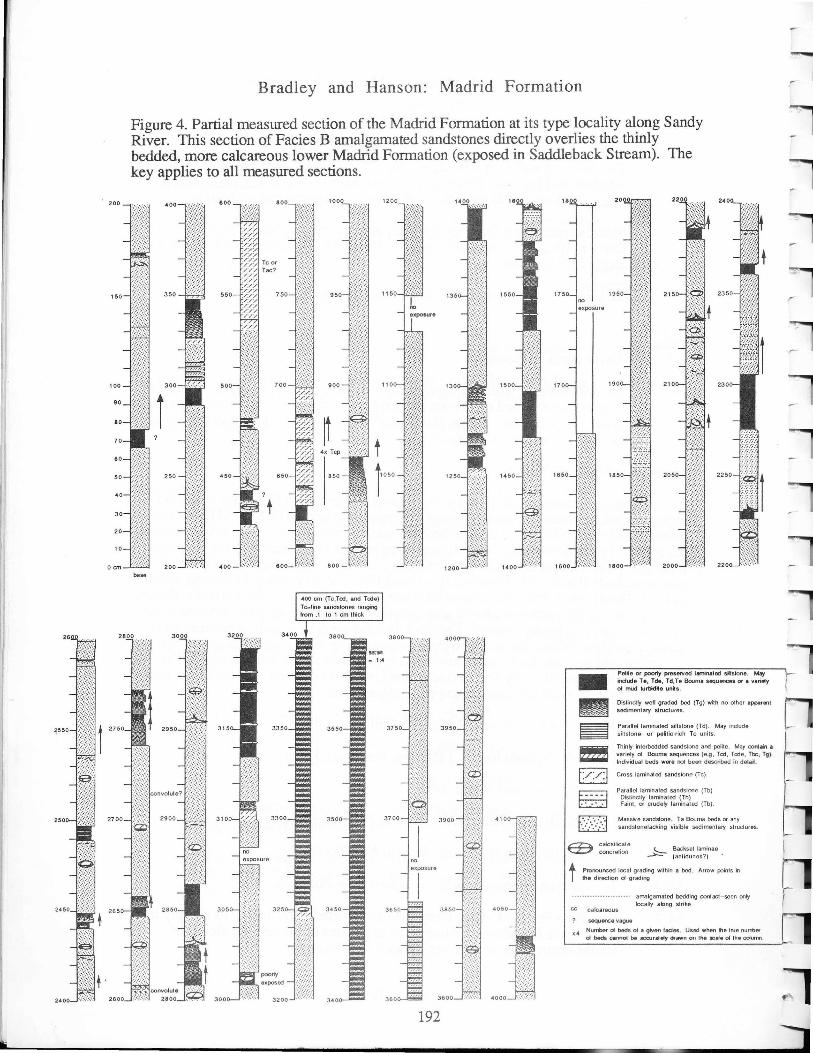
These outcrops at the type locality expose the transition from thinly-bedded, impure metalimestones and metapelites of the lower member of the Madrid Formation (along Saddleback Stream) to thicker-bedded, massive sandstones of the upper member of the Madrid Formation (along Sandy River). The section along Sandy River (Figure 4; this is the first published section from type locality) is mainly composed of amalgamated sandstone beds (Facies B). Convincing upward-thickening or upward-thinning trends are lacking. The absence of deeply channeled bases suggest deposition on a smooth-floored outer fan, while the predominance of amalgamated sandstones suggests deposition not far from the outlet of a feeder channeL The thick-bedded sandstones at first seem entirely massive and featureless, but on close inspection many beds display grading, rip-up clasts, convolute laminae, and large-scale, low-angle cross-laminae (backset laminae). The sandstones are typically very fine to fme grained; medium-grained sandstones are rare and restricted to the lowest few centimeters of sandstone beds.
24.5
38.5
38.75
39.0
44.2
50.4
54.7
Retrace route on Route 4 (S), past Phillips, to Strong.
Tum left (N) onto Route 145, cross the Sandy River.
Tum right (S) onto Route 149.
Tum left (E) onto Route 234; drive to New Vineyard.
Turn left (N) onto Route 27; drive to New Portland.
Turn east onto Route 146; drive to East New Portland.
East New Portland. Park along the road where Route 146 turns sharply left (N) to cross the Carrabassett River. The exposures of interest are along the southeastern bank of the river. Watch for poison ivy.
191
(
200
150
Bradley and Hanson: Madrid Formation
Figure 4. Partial measured section of the Madrid Formation at its type locality along Sandy River. This section of Facies B amalgamated sandstones directly overlies the thinly bedded, more calcareous lower Madrid Formation (exposed in Saddleback Stream). The key applies to all measured sections.
000
350 550 15
t
base
192
-.. ~ m! [//:1
B D
Path Of poony preserved laminated ~Islone . May indOOe Te, Tde, Td,le Bouma sequences or a vanaly of mod lurbidiht unils .
Dislindty well gradod bed (Tg) with no other apparent sedimentary structures.
Parallel laminated siltstone (Td). May include siNstone- or palilic-rich Te units.
Thinly interbedded sandslone and pelile. May ronIain II variety of Bouma sequences (e.g, Tcd, Tede, llx:, T9). Individual beds were nol been described in dela~.
Cross laminated sandstone (Tc).
Parallel laminated sandstone (Tb) Distinctly laminated (Tb) Faint, or audety laminated (Tb).
Massive sandstono . Ta Bouma bods or any sandSionelacking visible sedimentary strudU(9S.
calcsilicalo concretion !--.- Backse! laminae
~ (anlidunes?) -
t Pronounced local grading wilhin a bad. Arrow points in the direction 01 grading
calcareous
sequence vAgUe
amalgamated badding contact--seen only locally along strike
x'" Number 01 beds 0( II given l.oes. Used when th9 true nutrb9r 01 b8dB canool be MX1lr.oIy df_n on the scale 0( the column .
t h r

r Bradley and Hanson: Madrid Formation
STOP 2 - East New Portland
This is a good example of Cowan's (1985) Type I melange, consisting of variably disrupted turbidite beds and bed fragments of Madrid aspect, surrounded by a foliated metapelite matrix. Web structure is pronounced in sandstone blocks. East New Portland lies within the contact aureole of the nearby Lexington pluton (Figure 1). The melange is intruded by pegmatite dikes associated with the batholith. This pluton also cuts regional Acadian folds, and its contact aureole overprints regional biotite-grade metamorphism. An Rb-Sr isotopic age of 400 Ma for the Lexington (Gaudette and Boone 1985) brackets the age of older events. Deposition of the Madrid Formation, disruption of Madrid protoliths into melange, and Acadian regional deformation and metamorphism all must have occurred during the Pridolian-Gedinnian interval (about 414 to 401 Ma).
54.7 Drive north on Route 146, crossing the Carrabassett River.
54.85. Tum right (NE) onto River Road (shortcut).
56.75 Tum right (S) onto Route 16. Proceed slowly for about 0.2 miles and pull over at large roadcut.
STOP 3 (Optional) - Contact between Madrid and Smalls Falls Formations
In roadcuts on the left (NE) side of the highway, sulfidic, rusty-weathering metasandstones and metapelites of the Ludlovian Smalls Falls Formation are in contact with purplish-weathering metasandstones of the Pridolian-Gedinnian Madrid Formation (eastern facies, originally designated as Fall Brook Formation by Pankiwskyj 1979). According to Pankiwskyj (1979, p. 19) the contact is a 2 meter thick melange zone; he interpreted it to be a premetamorphic, soft-sediment slump surface.
57 .0 Continue on Route 16 to North Anson.
64.25
64.4
North Anson village. Tum right (S) on Route 201A. Cross the Carrabassett River.
Turn around and park on the northeast side of the road (Figure 5) where there is a very wide, paved shoulder.
~_~,oo METERS
Figure 5. Sketch map of outcrops (stippled with strike lines of bedding and/or melange foliation) along the Carrabassett River in North Anson.
193

Bradley and Hanson: Madrid Formation
STOP 4A - North Anson Bridge
Cross to the west side of Route 201A and descend the embankment. About 100 meters south of the river is a series of recent exposures in which characteristic sedimentary features of the Madrid Fonnation are locally well displayed. A partial measured section (Figure 6) shows the abundance of amalgamated sandstones (Facies B). The bases of thick sandstone beds show characteristically rapid grading; backset laminae are also present. Younging direction, inferred from grading and backsets, is to the southeast. The outer-fan depositional setting was probably comparable to that at Stop 1.
64.4
64.55
64.75
Retrace route to center of North Anson.
Turn left on Route 16.
Park in front of the Public Library just beyond a bridge over Mill Stream, a tributary of the Carrabassett River. Climb over the guardrail and descend a concrete retaining wall to the river. For less agile participants, there is an easier but longer way down about 0.1 miles upstream, beneath the railroad bridge; the latter route involves some disagreeable bushwhacking in order to reach the best outcrops just below the library.
This will be our lunch stop. Food is available at the general store in North Anson.
STOP 4B - North Anson Melange
Exposures along the Carrabassett River from Mill Stream to the railroad bridge (Figure 5) are mostly melange. The melange is a stratabound package about 30 meters thick, bounded below and above by somewhat disrupted, but more nearly intact turbidites. The lower and upper boundaries of the melange zone are gradational; there is no evidence for a welded (sedimentary) upper contact such as would be expected if the melange were a slump deposit. The melange consists of disrupted layers and fragments of metasandstone, enclosed in a matrix of metapelite. Fragmentation of sandstone layers had progressed to varying degrees when defonnation ceased, leaving a spectrum ranging from essentially intact bedding, to web structure, to partially dismembered but still recognizable layers, to isolated fragments with no obvious relation to neighboring fragments (Figure 3). Bedding is generally parallel to foliation in zones of relatively less intense defonnation, but is commonly perpendicular to foliation in fragments in the more disrupted zones. The most prominent layering is a fragment foliation (Cowan 1985) defined by flattened metasandstone fragments surrounded by anastomosing films or zones of darker, finergrained material; we interpret the foliation as a plane of bedding-parallel simple shear. Clasts are elongated subvertically in the flattening (foliation) plane. Byrne (1984) noted that bedding disrupted by web structure tends to break into prisms that initially are elongated perpendicular rather than parallel to the extension direction; consequently, the shear direction and sense are ambiguous.
The North Anson melange developed within partially lithified Madrid Formation turbidites. At the time of deformation, sand beds were sufficiently cohesive for fragmentation into blocks, as opposed to disaggregation into individual sand grains; at the same time, pelite was sufficiently mobile to flow into some available openings. Similar Type 1 melanges have been described by Byrne (1984) from the Ghost Rocks Formation, Alaska, where they have been attributed to early submarine thrusting in a subduction
194

-,.
"'"'
....
Bradley and Hanson: Madrid Formation
Figure 6. Partial measured section of the Madrid Formation at North Anson, south of the bridge over the Carrabassett River on US 20lA. Turbidite facies here include Facies B (predominant), C, D, and F.
2:508 .... : ... ·:. --. -:-:-.:-.
800 1975
t in sect ion
100 5 2000
90
80
? 1975
70
60
50
40 lOm± br •• k in
30 ~e-ction
20
1 a
a em 800
195

Bradley and Hanson: Madrid Formation
complex. The melange at North Anson may represent what was originally a flat-on-flat thrust zone. Soon after the melange formed, the entire duplicated section was subject to regional Acadian folding.
64.75
65.0
71.5
71.6
71.65
Retrace path to intersection of Routes 16 and 20lA in North Anson village.
Turn left (N) onto Route 201A, eventually crossing the Kennebec River, to Solon.
Solon village; turn left onto U.S. Route 201.
Turn left on Cross Street, drive about 200 feet
Park opposite first driveway (please do not block local traffic). Scramble down a short trail to the brook.
STOP 5 - Fall Brook
Pankiwskyj and others (1976) designated this as the type section of the Fall Brook Formation (Figure 7), a name later abandoned by Moench and Pankiwskyj (1988) in favor of the informal designation "eastern facies" of the Madrid Formation. This is a classic thickening-upward sequence (Figure 7b), suggesting progradation in an outer fan environment. Southwesterly paleocurrent directions from cross laminae suggest that progradation was along strike toward the southwest. The field trip will visit the area of measured section 7e, characterized by abundant backset laminae and high ratio of sandstone to shale.
71.65
71.7
72.3
72.6
Retrace path to Route 201.
Turn left on Route 201.
Turn left onto Falls Road.
Park at a large cleared area overlooking a dam and what is left of Caratunk Falls on the Kennebec River. Archeological digs at the falls (for millenia a seasonal salmon fishing camp) have revealed artifacts as old as Middle Archaic (about 7500 years before present), as well as the much younger Woodland and Contact periods. A plaque commemorates the portage of Benedict Arnold's fleet of leaky bateaux here in October, 1775, during his campaign against Quebec in the early days of the Revolutionary War.
Walk downstream about 500 feet along a dirt road. Where it ends, follow a rough path to the right (watch for poison ivy) about 100 feet to large exposures along the river. Initials carved in the outcrop near its downstream end read "BA 1775".
STOP 6 - Arnolds Landing
This stop features excellent exposures of the uppermost Madrid and lowermost Carrabassett Formations, and a passable exposure of the conformable contact. Figure 8 shows a detailed measured section across the contact and the transition from submarine fan to slope facies; the section begins at the river. The upper Madrid Formation consists of partial to complete Bouma sequences (Facies C and D) and amalgamated sandstones with
196

[
~ [
[
[
Bradley and Hanson: Madrid Formation
Figure 7. The outcrop belt at Fall Brook in Solon was the designated type section of the now-abandoned Fall Brook Formation (Pankiwskyj and others 1976); it now serves as a reference section for the informal "eastern facies" of the Madrid Formation. (a) Location sketch map. (b). Summary section showing thickening upward sequence. Letters show stratigraphic position of detailed measured sections (c, d, and e).
(a) Location ma p ( b ) Summa r y sec t ion
(c) Detail at locat ion c
1000
600
(d) De t a il at loca t ion d (e) Detail at location e 197

Bradley and Hanson: Madrid Formation
erosive bases (Facies B). Channeling suggests a more proximal (e.g. mid-fan) depositional setting than the outer fan facies at Stops 1,4, and 5. Paleocurrents obtained by single-tilt correction of cross laminae in Facies D turbidites suggest sediment transport toward the southwest, subparallel to strike. Together, this suggests fan progradation toward the southwest.
A slump horizon can be seen about 10 meters from the water's edge; contractional deformation in the slump mass suggests that it may have accumulated near the base of a slope. Near the water's edge, an early fault with ramp-on ramp and flat-on-ramp geometries is interpreted as a contractional structure that probably predated or accompanied regional deformation.
The abrupt depositional contact between the Madrid and overlying Carrabassett Formation is poorly exposed in the woods along the access trail. Good exposures of the lowermost Carrabassett Formation are found a few tens of meters downstream. Bedding in these metapelites is marked by thin siltstone laminae, some of which are graded. They are interpreted as mud turbidites deposited on a submarine slope.
72.6 Retrace path to North Anson.
-80 Follow Route 201 to Anson
-85 Tum right on Route 43. Drive to Farmington where trip mileage began.
-105 END OF TRIP
198

I: 0 ..... ..... C':j
8 t-. 0 ~
"'0 ..... t-.
"'0 C':j
::E I: 0 r/:J I: C':j
:.:r:: "'0 I: C':j
;>.. II) -"'0 C':j t-.
CO
r
4~ 8_
x 12
i4.8 ---- - ~ ~ [··· ·······l cc
'I '11 -- --- -, ,/ ,,, ,,
.. _-_. """
~ l;2.::'-:.j cc
cc
2 __ -,I; 6 "", ,, ~~~~~~ cc
-m t : ',':',': ', -0 ripups
11 s lump 1;;;;;J 1 5 ... . . .::::: cc
meters O~ 4
base of ~xposed section at Kennebec River
t ·r r·
12 _
"I :::}:::(:::: ::.:«<:.:.:
=I ;,:,,:.:.; :.
1'" ,,,., 10 "u"
"'"''' '
Figure 8. Partial measured section at Arnolds Landing, showing the uppermost eastern facies of the Madrid Formation, the lowermost Carrabassett Formation, and the abrupt depositional contact between.
16 -,. .. : .. : .... , 20_ 2 4 ___ "I ,,- "" ""~ 4n _ ',:::',:::',:::
iJ l'~::;!:;i:\l :::;:~:}:): dish ...... :::.\:.\:i: s truct . ,"',:'.:'
'::: .. :'::: .. :'/":'
15 .. : .... : .. :: .. 19 -j"-.'.·.:·.:·.:'.] 23 --1'.\'.\'.\1 27 -t·::·::·: l 3 1 --1:: : : :··1 35 //hl,
"""" """ """',, ... """" ,'///'/
""" ","'" ,'/""
,ji ..... - 11 18 .: ::::. ~ 22 ~:.~:.~:: ...... : ... : ... j ! 26 -.· . .. · "j 34 ,,1,
-i ~LV -r····] 1 7 1:{r.t~tl 21_ -I JJJ 33--1 37 --1 9 5 lump 1 3 :i:::i::i\ 25 29 .:.:.:.:.:.:
_. -- ::::::.:::::::.:::).::: x22
12 16 20
24 28 32 36
(
44~ 48
,,1, --I 0\ 0\ .......
41--1 45-& t
40

New England Intercollegiate Geological Conference 81 st Annual Meeting
Guidebook for Field Trips in
SOUTHERN AND WEST -CENTRAL
MAINE October 13, 14 and 15, 1989
Hosted by the Department of Sciences and Mathematics
University of Maine at Farmington Farmington, Maine
Editor Archie W. Berry, Jr.