trekking epic madeira 2018 - madeiraislandnews.com · madeira as a sea-wolf (monachus monachus). at...
TRANSCRIPT
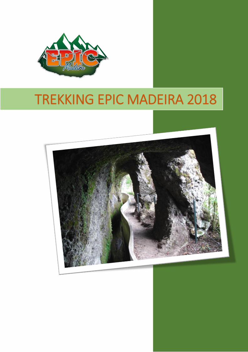
TREKKING EPIC MADEIRA 2018
SENDERISMO| EPIC MADEIRA 2018
Página 2
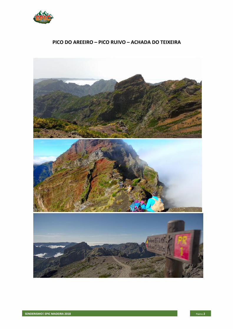
PICO DO AREEIRO – PICO RUIVO – ACHADA DO TEIXEIRA
SENDERISMO| EPIC MADEIRA 2018
Página 3
This trail is unique in that it links two of the highest peaks of Madeira Island, Pico Ruivo (1862 m) and Pico do Areeiro (1817 m), traversing part of the Central Mountain Massif, an area integrated in the Natura 2000 Network. Starting at Pico do Areeiro, within a short distance we come upon the Ninho da Manta (Buzzard’s Nest) belvedere. From this platform where this bird of prey is supposed to have bred, one can see the valley of Fajã da Nogueira, where some Manx shearwater (Puffinus puffinnus) breed, São Roque do Faial and a large part of the Central Mountain Range. This is the only known breeding site in the world of Zino’s petrel (Pterodroma madeira), a species endemic to the island and considered to be the most endangered seabird of Europe. To reach Pico Ruivo, we must go around Pico das Torres up a steep incline of steps carved in the rock and then descend, the most difficult part of this trail being the final climb to the Shelter at Pico Ruivo. But the thought of reaching the highest point of the island is a driving force. Along the way, we find various caves dug out of the volcanic tuff where the cattle took refuge and which served as shelter for the shepherds; we can also see various birds, some of the more important ones being species restricted to Macaronesia, the canary (Serinus canaria), Berthelot’s pipit (Anthus berthelottii madeirensis) and the plain swift (Apus unicolor), as well as other subspecies found only in the Madeira archipelago: the Madeira rock sparrow (Petronia petronia madeirensis), chaffinch (Fringilla coelebs madeirensis), and the firecrest (Regulus ignicapillus madeirensis). For those who enjoy plants, this area is known as a high-altitude heath and is marked by the presence of various endemisms of Madeira, which include the Madeira violet (Viola paradoxa), Madeira grey heather (Erica madeirensis), the rock orchid (Orchis scopolorum), and the Madeira kidney (Anthyllis lemanniana). Near the Pico Ruivo shelter, you will find footpath PR 1.2, which leads to Achada do Teixeira. At Achada do Teixeira you can see “Homem em pé” (Standing Man), a basalt rock formation found on the way down the slope after you pass the shelter at Achada do Teixeira.
Pick up From 08h30m
Duration 04H00 to 05H30
Distance 13km
Difficulty Difficult
Altitude min./máx. 1862m/1542m
Drop off Between 15h00 and 16h00
SENDERISMO| EPIC MADEIRA 2018
Página 4
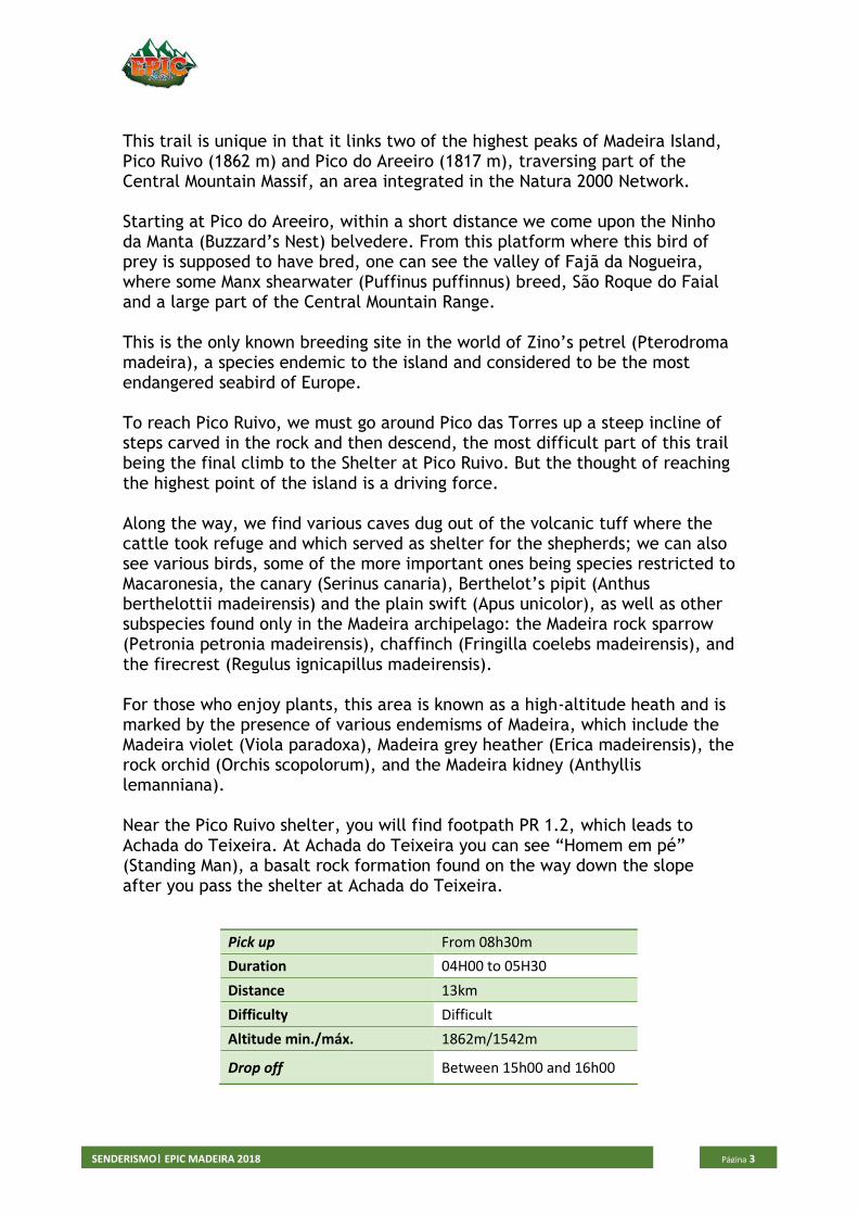
RABACAL – 25 FOUNTAINS
SENDERISMO| EPIC MADEIRA 2018
Página 5
Visiting a spectacular waterfall, this walks begins by descending gently to Rabaçal before continuing downhill to view the waterfall. Both trails begin on the regional road (E.R. 110), and go down as far as the Rabaçal government house. The trails diverge along two parallel levadas located on different levels. Trail PR 6.1, goes along Levada do Risco, at 1000m above sea level, taking the hiker to an impressive waterfall, which falls horizontally creating a ridge in the rock. If you go down to PR6 you can visit the 25 Spring Lagoon (Lagoa das 25 Fontes), created by the waters which come down from the Mountain Marsh (Paul da Serra) and mysteriously appear from behind the wall that forms the lagoon, where you can see more than 25 springs. Legend says that whoever was to dive here would never come back up to the surface, which is what happened to an Englishman who wanted to break the superstition and was never seen again. At this height the landscape is dominated by moorland, which includes Erica arborea and Erica scoparia ssp maderensis as well as Madeiran whortleberry (Vaccinium padifolium). This vegetation changes as altitude lowers, with other species predominating, including the rare mountain mocano (Pittosporum coriaceum). This area includes the Madeiran laurisilva forest which has classified as a Natural Heritage Site by UNESCO, since December 1999 and is part of the European network of important community sites - Natura 2000. The Trocaz Pigeon (Columba trocaz trocaz) lives and nests here, the bird is exclusively endemic to Madeira Island. The 25 Fontes levada, which is also known as Levada Nova do Rabaçal, began to be built in 1835. On 16 September 1855 water ran through the levada for the first time, running from North to South and making it possible to make use of lots of land which had so far lain fallow in the Calheta municipal area. The two levadas bring together water from two tributaries of Ribeira Grande and run into the Calheta Hydroelectric Dam, and carries on to irrigate agricultural land. Levadas, is the name given on the island to the small aqueducts that make up a vast irrigation system, built through the physical strength of our ancestors who, overcoming the height of the island, brought together the water from thousands of springs and took it to the fields.
Pick up From 08h30m
Duration 04H00 to 04H30
Distance 10km
Difficulty Moderate
Altitude min./máx. 12900/900m
Drop off Between 15h00 and 16h00
SENDERISMO| EPIC MADEIRA 2018
Página 6
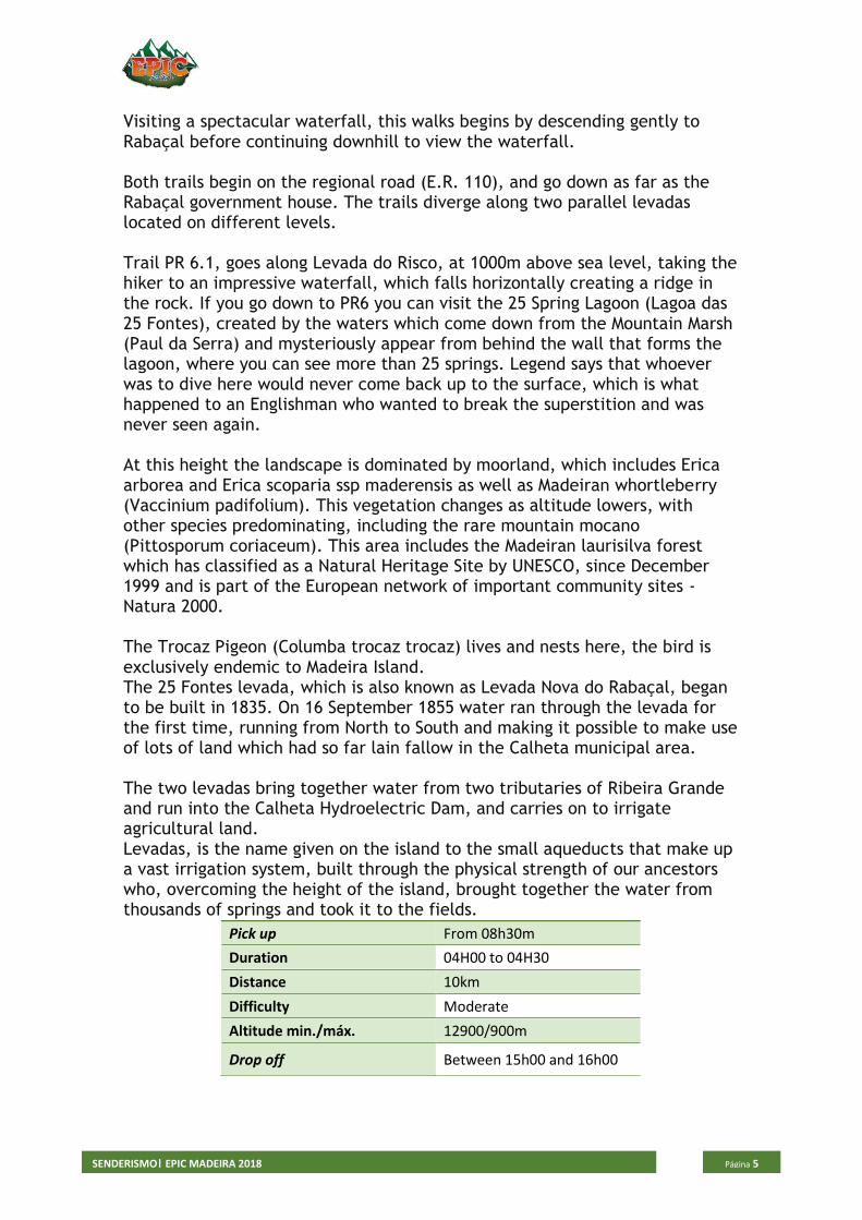
LEVADA DO CALDEIRAO VERDE
SENDERISMO| EPIC MADEIRA 2018
Página 7
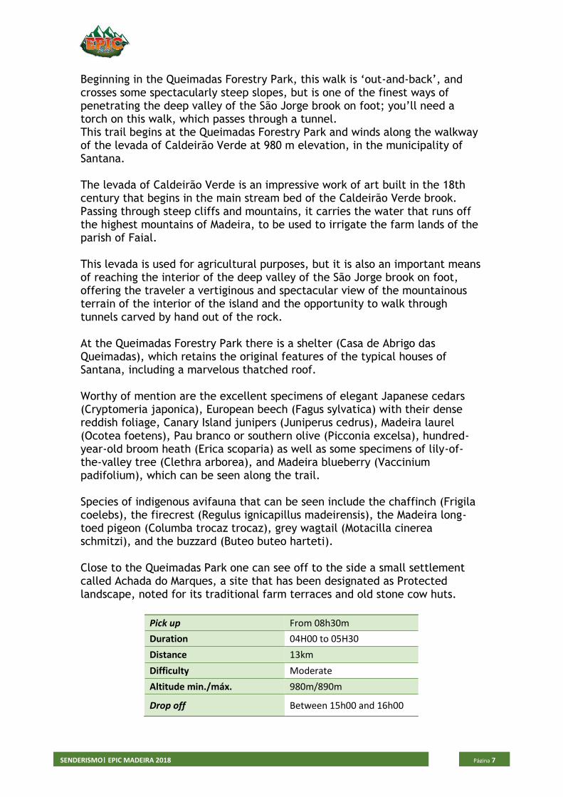
Beginning in the Queimadas Forestry Park, this walk is ‘out-and-back’, and crosses some spectacularly steep slopes, but is one of the finest ways of penetrating the deep valley of the São Jorge brook on foot; you’ll need a torch on this walk, which passes through a tunnel. This trail begins at the Queimadas Forestry Park and winds along the walkway of the levada of Caldeirão Verde at 980 m elevation, in the municipality of Santana. The levada of Caldeirão Verde is an impressive work of art built in the 18th century that begins in the main stream bed of the Caldeirão Verde brook. Passing through steep cliffs and mountains, it carries the water that runs off the highest mountains of Madeira, to be used to irrigate the farm lands of the parish of Faial. This levada is used for agricultural purposes, but it is also an important means of reaching the interior of the deep valley of the São Jorge brook on foot, offering the traveler a vertiginous and spectacular view of the mountainous terrain of the interior of the island and the opportunity to walk through tunnels carved by hand out of the rock. At the Queimadas Forestry Park there is a shelter (Casa de Abrigo das Queimadas), which retains the original features of the typical houses of Santana, including a marvelous thatched roof. Worthy of mention are the excellent specimens of elegant Japanese cedars (Cryptomeria japonica), European beech (Fagus sylvatica) with their dense reddish foliage, Canary Island junipers (Juniperus cedrus), Madeira laurel (Ocotea foetens), Pau branco or southern olive (Picconia excelsa), hundred-year-old broom heath (Erica scoparia) as well as some specimens of lily-of-the-valley tree (Clethra arborea), and Madeira blueberry (Vaccinium padifolium), which can be seen along the trail. Species of indigenous avifauna that can be seen include the chaffinch (Frigila coelebs), the firecrest (Regulus ignicapillus madeirensis), the Madeira long-toed pigeon (Columba trocaz trocaz), grey wagtail (Motacilla cinerea schmitzi), and the buzzard (Buteo buteo harteti). Close to the Queimadas Park one can see off to the side a small settlement called Achada do Marques, a site that has been designated as Protected landscape, noted for its traditional farm terraces and old stone cow huts.
Pick up From 08h30m
Duration 04H00 to 05H30
Distance 13km
Difficulty Moderate
Altitude min./máx. 980m/890m
Drop off Between 15h00 and 16h00
SENDERISMO| EPIC MADEIRA 2018
Página 8
VEREDA DA PONTA DE SÃO LOURENÇO
SENDERISMO| EPIC MADEIRA 2018
Página 9
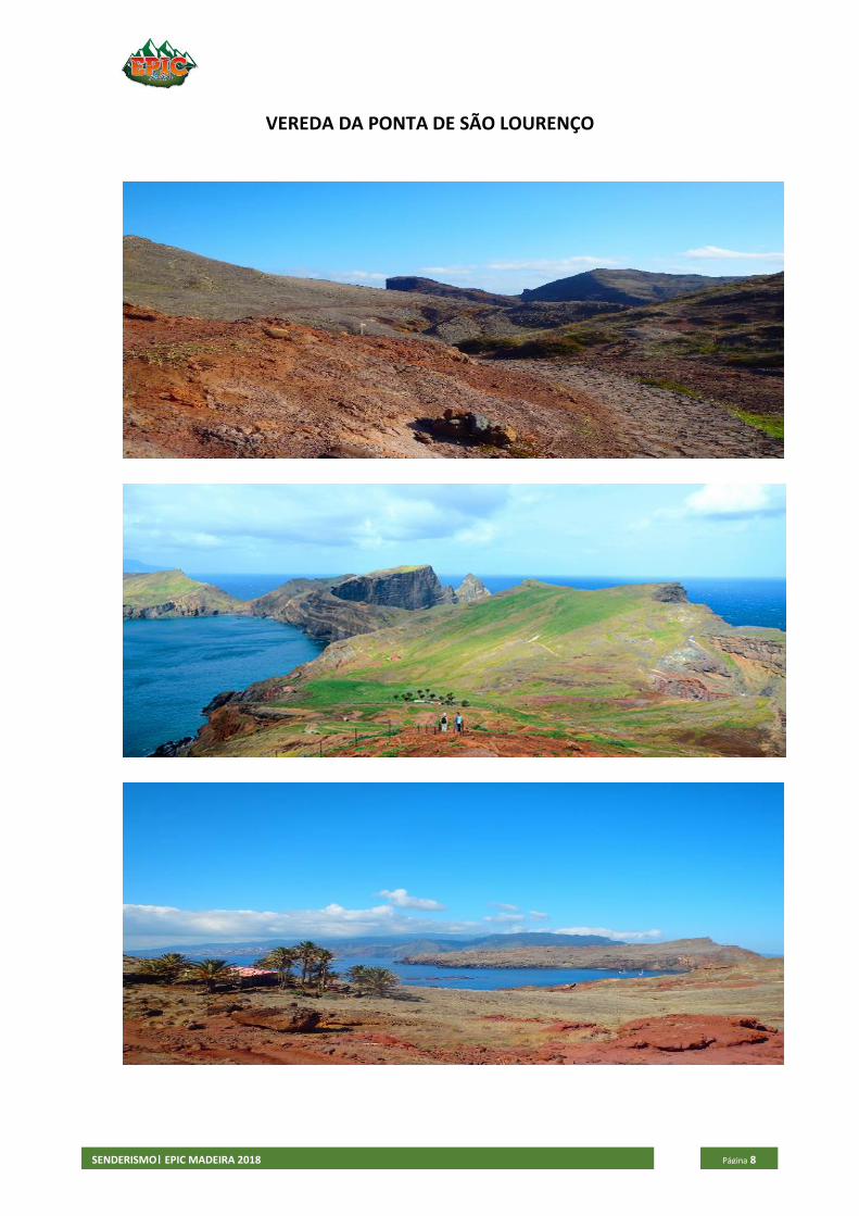
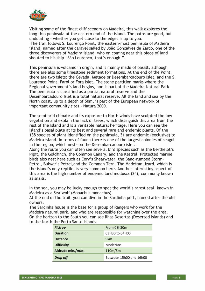
Visiting some of the finest cliff scenery on Madeira, this walk explores the long thin peninsula at the eastern end of the island. The paths are good, but undulating - whether you get close to the edges is up to you. The trail follows S. Lourenço Point, the eastern-most peninsula of Madeira island, named after the caravel sailed by João Gonçalves de Zarco, one of the three discoverers of Madeira island, who on coming near this piece of land shouted to his ship “São Lourenço, that’s enough!”. This peninsula is volcanic in origin, and is mainly made of basalt, although there are also some limestone sediment formations. At the end of the Point there are two islets: the Cevada, Metade or Desembarcadouro Islet, and the S. Lourenço Point, Farol or Fora Islet. The stone partition marks where the Regional government’s land begins, and is part of the Madeira Natural Park. The peninsula is classified as a partial natural reserve and the Desembarcadouro Islet is a total natural reserve. All the land and sea by the North coast, up to a depth of 50m, is part of the European network of important community sites - Natura 2000. The semi-arid climate and its exposure to North winds have sculpted the low vegetation and explain the lack of trees, which distinguish this area from the rest of the Island and is a veritable natural heritage. Here you can see the Island’s basal plate at its best and several rare and endemic plants. Of the 138 species of plant identified on the peninsula, 31 are endemic (exclusive) to Madeira island. In terms of fauna there is one of the largest colonies of seagull in the region, which nests on the Desembarcadouro islet. Along the route you can often see several bird species such as the Berthelot’s Pipit, the Goldfinch, the Common Canary, and the Kestrel. Protected marine birds also nest here such as Cory’s Shearwater, the Band-rumped Storm-Petrel, Bulwer’s Petrel,and the Common Tern. The Madeiran lizard, which is the island’s only reptile, is very common here. Another interesting aspect of this area is the high number of endemic land molluscs (24), commonly known as snails. In the sea, you may be lucky enough to spot the world’s rarest seal, known in Madeira as a Sea-wolf (Monachus monachus). At the end of the trail, you can dive in the Sardinha port, named after the old owners. The Sardinha house is the base for a group of Rangers who work for the Madeira natural park, and who are responsible for watching over the area. On the horizon to the South you can see Ilhas Desertas (Deserted Islands) and to the North the Porto Santo Islands.
Pick up From 08h30m
Duration 03H30 to 04H00
Distance 9km
Difficulty Moderate
Altitude min./máx. 110m/5m
Drop off Between 15h00 and 16h00
SENDERISMO| EPIC MADEIRA 2018
Página 10
LEVADA DO FURADO – RIBEIRO FRIO - PORTEA
SENDERISMO| EPIC MADEIRA 2018
Página 11
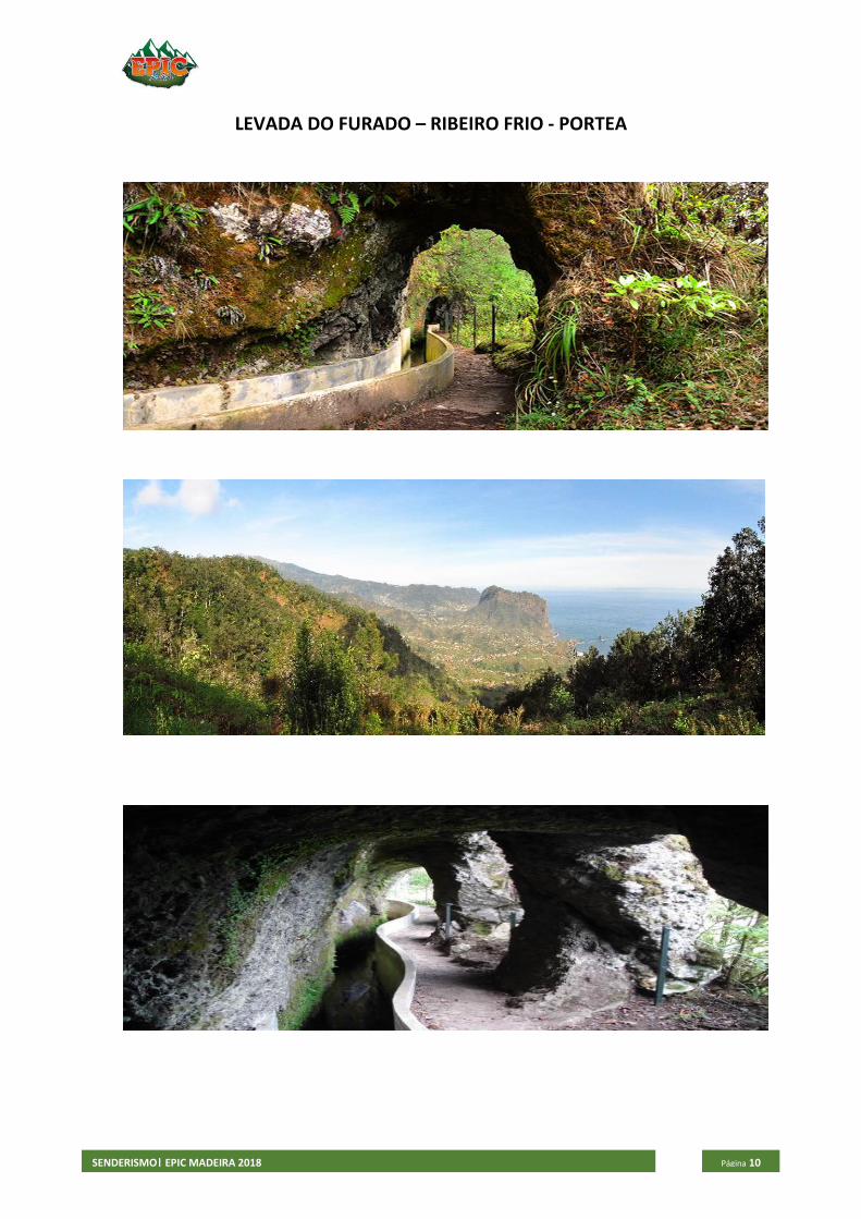
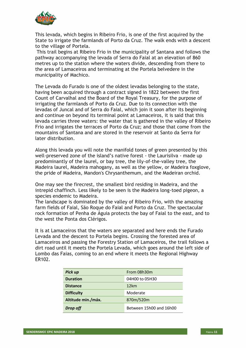
This levada, which begins in Ribeiro Frio, is one of the first acquired by the State to irrigate the farmlands of Porto da Cruz. The walk ends with a descent to the village of Portela. This trail begins at Ribeiro Frio in the municipality of Santana and follows the pathway accompanying the levada of Serra do Faial at an elevation of 860 metres up to the station where the waters divide, descending from there to the area of Lamaceiros and terminating at the Portela belvedere in the municipality of Machico. The Levada do Furado is one of the oldest levadas belonging to the state, having been acquired through a contract signed in 1822 between the first Count of Carvalhal and the Board of the Royal Treasury, for the purpose of irrigating the farmlands of Porto da Cruz. Due to its connection with the levadas of Juncal and of Serra do Faial, which join it soon after its beginning and continue on beyond its terminal point at Lamaceiros, it is said that this levada carries three waters: the water that is gathered in the valley of Ribeiro Frio and irrigates the terraces of Porto da Cruz; and those that come from the mountains of Santana and are stored in the reservoir at Santo da Serra for later distribution. Along this levada you will note the manifold tones of green presented by this well-preserved zone of the island’s native forest - the Laurisilva - made up predominantly of the laurel, or bay tree, the lily-of-the-valley tree, the Madeira laurel, Madeira mahogany, as well as the yellow, or Madeira foxglove, the pride of Madeira, Mandon's Chrysanthemum, and the Madeiran orchid. One may see the firecrest, the smallest bird residing in Madeira, and the intrepid chaffinch. Less likely to be seen is the Madeira long-toed pigeon, a species endemic to Madeira. The landscape is dominated by the valley of Ribeiro Frio, with the amazing farm fields of Faial, São Roque do Faial and Porto da Cruz. The spectacular rock formation of Penha de Águia protects the bay of Faial to the east, and to the west the Ponta dos Clérigos. It is at Lamaceiros that the waters are separated and here ends the Furado Levada and the descent to Portela begins. Crossing the forested area of Lamaceiros and passing the Forestry Station of Lamaceiros, the trail follows a dirt road until it meets the Portela Levada, which goes around the left side of Lombo das Faias, coming to an end where it meets the Regional Highway ER102.
Pick up From 08h30m
Duration 04H00 to 05H30
Distance 12km
Difficulty Moderate
Altitude min./máx. 870m/520m
Drop off Between 15h00 and 16h00
SENDERISMO| EPIC MADEIRA 2018
Página 12
VEREDA DO LARANO
SENDERISMO| EPIC MADEIRA 2018
Página 13
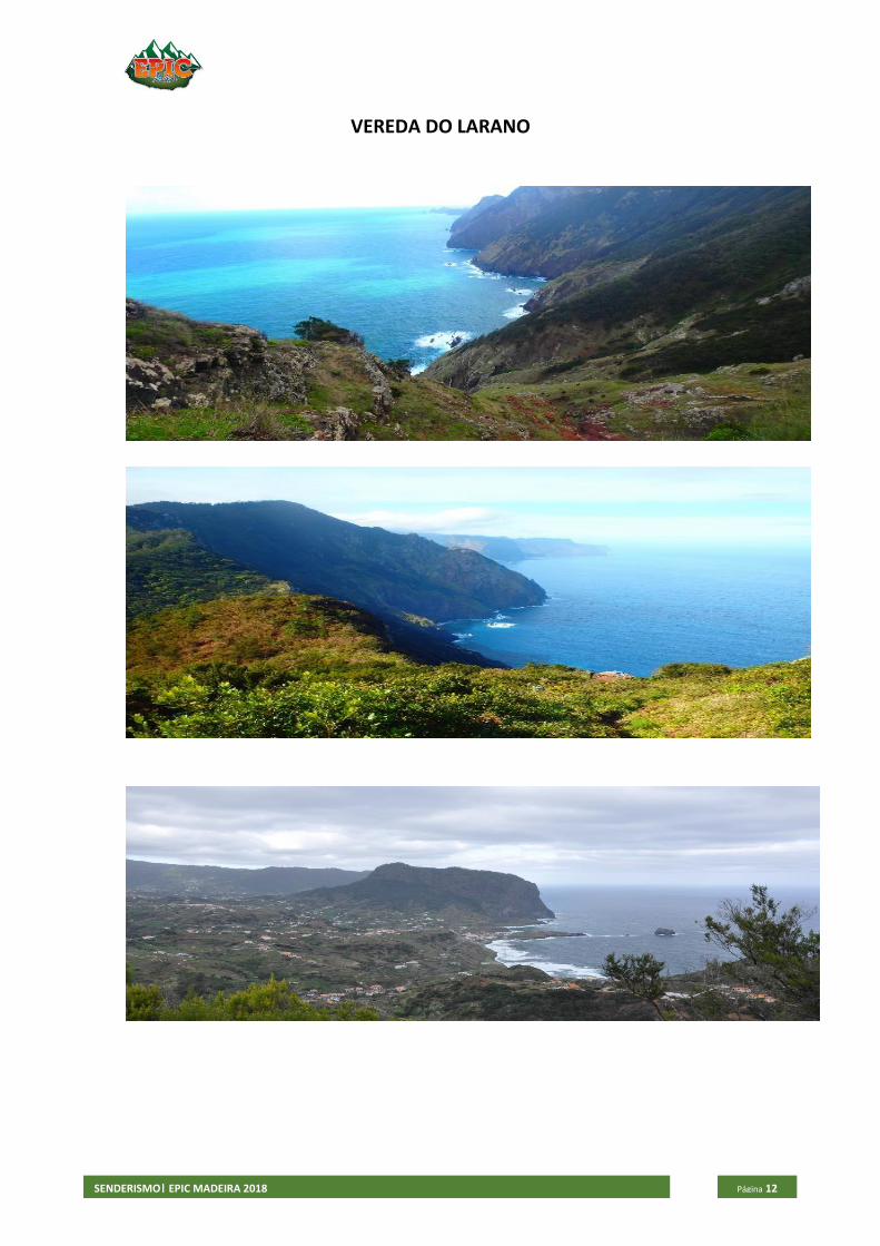
This is undoubtabley one of the best hiking routes in the entire island.
The nature is overwhelming with species of Fauna and Flora that can be
found only here.
This trail begins in Machico, next to the old tunnel that connects Machico to
Caniçal, and guides the walkers to Porto da Cruz, through a path that was
once used by the local population to move between these two locations.
The beginning of this trail is accessible to anyone, by the Levada of Maroços
that offers fascinating perspectives on Machico until you reach the viewing
spot of Boca do Risco, where hikers can enjoy a wonderful view over the north
coast of the island.
From here, towards Porto da Cruz, the hiking route is of high difficulty. The
path is made by the path carved into the rock with a view over the vast
Atlantic Ocean, on a narrow and unprotected path, and is therefore
recommended only to experienced hikers.
Along the way take the opportunity to enjoy the views of all around this walk.
In Porto da Cruz, relax a little and get to know this town on the island, full of
unique cultures and traditions.
Pick up From 08h30m
Duration 04H00 to 05H30
Distance 13km
Difficulty Difficult
Altitude min./máx. 356m/20m
Drop off Between 15h00 and 16h00
SENDERISMO| EPIC MADEIRA 2018
Página 14
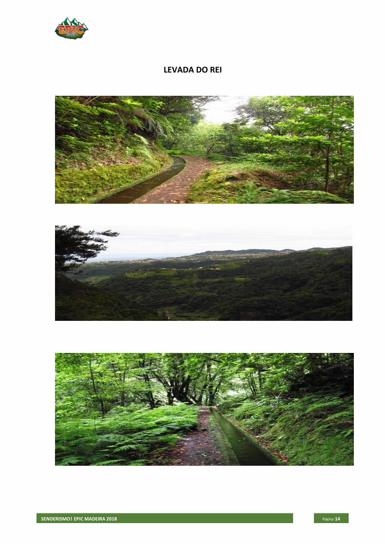
LEVADA DO REI
SENDERISMO| EPIC MADEIRA 2018
Página 15
In the northern part of the island, this route is linear but makes a return by the outward route. There are tunnels on this walk, for which a torch is essential. The first part of the trail follows the levada through an afforested area, but offers spectacular views of the São Jorge and Santana farmlands. The trail that follows alongside the Levada do Rei begins at the Water Treatment Plant at Quebradas in São Jorge, ending at the source of the levada in the spectacular Ribeiro Bonito stream. The first part of the trail crosses a forested area where some specimens of indigenous vegetation are found here and there. This initial leg of the trail presents travellers with beautiful panoramic views of the São Jorge and Santana farmlands. After the midway point of the trail, the levada that winds from the interior of the island along the mountain slopes passes through a spectacular area of native forest which is well developed and rich in natural biodiversity. The tunnels formed by the luxuriant vegetation and the great variety of species that you can find here are excellent living examples of the potential of nature, while the beautiful levada is evidence of the valuable cultural heritage of the island. The path ends at Ribeiro Bonito, where you are aware of feeling you are in a true sanctuary of nature. This is one of the areas of the Laurisilva forest - World Nature Heritage of UNESCO since 1999, where the genuinely Madeiran vegetation reaches its highest expression and its location and isolation leave one with the sensation of having gone back in time to the discovery of the island. The permanent presence of clear water in this location intensifies the abundant life forms here and allows a great diversity of species to thrive. You can take delight in the majestic centenary Madeira laurels (Ocotea foetens), the laurel trees (Laurus novocanariensis), the Madeira mahogany (Persea indica), and in the tiny birds like the firecrest (Rugulus ignicapillus maderensis), and the chaffinch (Fringilla coelebs maderensis), species that bring vitality to this ecosystem and please the ear with their songs.
Pick up From 08h30m
Duration 03H30 TO 04H30
Distance 10km
Difficulty Easy to Moderate
Altitude min./máx. 710m/530m
Drop off Between 15h00 and 16h00
SENDERISMO| EPIC MADEIRA 2018
Página 16
Trekking Days
Monday
• Ribeiro Frio - Portela
Tuesday
• Ponta de São Lourenço
Wednesday
• Rabaçal – 25 Fontes
Thursday
• Caldeirão Verde
Friday
• Highest Peaks(Pico do Areeiro – Pico Ruivo – Achada do Teixeira)
Saturday
• Levada do Rei – Ribeiro Bonito
Sunday
• Larano
Includes:
• Specialized and certified guide
• Transportation
• Insurance
Price per person:
• 35€
Changes to the program and in the order of the hikes can occur if bad weather conditions jeopardize the safety of the group.

SENDERISMO| EPIC MADEIRA 2018
Página 17
EPIC Madeira
Alvará: 1161/2017
Travessa do Forno Nº25, 9000-077 Funchal
+351 965 108 967 / +351 933 668 228
http://www.epicmadeira.com