trekker: a single app for all your treks - ijca ... · pdf fileinternational journal of...
TRANSCRIPT
International Journal of Computer Applications (0975 – 8887)
Volume 140 – No.12, April 2016
40
Trekker: A Single App for all your Treks
Marita S. B.E. Student
St. Francis Institute of Technology Mumbai, India
Anu A. B.E. Student
St. Francis Institute of Technology Mumbai, India
Makarand T. B.E. Student
St. Francis Institute of Technology Mumbai, India
Supriya Y. B.E. Student
St. Francis Institute of Technology Mumbai, India
Vipula R. Assistant Professor St. Francis Institute
of Technology Mumbai, India
ABSTRACT
Trekking is an activity in which people take hiking trips
through rural, often rugged territory. As travelers move
through rural areas, trekking gives them an up-close view of
the scenery. There are innumerable trekking places in the state
of Maharashtra. Some spots are well known whereas some are
still isolated. The information required by a trekker includes
locating nearby trekking spots, the difficulty level involved in
trekking, reviews of the people who have already been there,
directions and the climatic condition of the place. In this
paper, an android application that helps one to easily discover
unusual trekking locations that are otherwise not much talked
about, mentioned or is difficult to discover is introduced. This
is a completely user friendly application, providing the best
destination match and is more convenient than referring to
any travel book or map.
General Terms
Android Application
Keywords
Global Positioning System (GPS), Android App, Trekking,
User Friendly, Ionic, Cordova.
1. INTRODUCTION Trekking is an adventurous journey to discover the diversity
of nature and culture by foot on hills or high mountain areas
which is yet not accessible by modern transportation. Due to
the modern hectic lifestyle, need for relaxing and distressing
is felt. Travelling has always been the best option to relax.
TREKKER is an application which is specially designed for
this purpose allowing trekkers to detect their current location
using Global Positioning System (GPS) available in the
android phones. Accordingly, it provides the nearest trekking
locations based on their current position and sorts the areas
according to their climatic conditions, difficulty level etc. It
allows one to share their experience with other users as well.
It gives useful information about the desired trekking spot
such as images and overview of the spots. One can also
upload photos or post reviews for that place so that they can in
turn help out other trekkers to review the place before they go
out on their trekking expedition. The focus of this study is to
create an application which helps one to easily discover rare
and unique trekking locations, provide crucial information to
appease the habit of sharing socially, save searching time by
entering location manually so as to have an easy to use quick
app.
2. LITERATURE REVIEW Sawsan Alshattnawi’s and et.al paper gives a great overview
about android framework which has helped in understanding
the fundamentals of android platform. It also provides proper
and systematic working of the tourist guide program which
aids to conceive the back-end working. It has helped in
understanding the stages at which user can store his feedback
and images into the database [1].
Prof. Seema Vanjire’s and et.al paper helps to understanding
the importance of an android application that gives the users
real time and exact information. It also adds a lot of
information about the basic working of the GPS. For tracking
the user’s current location in the application the same has
been used. Google Application Program Interface (API) is
pivotal in plotting the trekking spots on the map [2].
The use of climatic knowledge in the application is an
important idea given in by Bagrecha Komal and et.al.
Whenever user plans to go for a trek, the user should be aware
about the climate, as it can affect the trekking experience. For
this purpose, the climate details for every location that in the
application covers have been stored into the database [3].
3. PROPOSED WORK An application that allows users to access all the useful
information at their fingertips has been proposed. It is
developed on an android platform which is user friendly and
reliable.
3.1 Scope of the Project TREKKER will provide the users with an easy experience of
trekking where they can always rely on the app for choosing
the perfect trek. This app may or may not cover all the
additional places and trekking spots within the boundaries of
Maharashtra but with future enhancements and user reviews
this shortcoming will also be covered up soon. Sometimes
describing a spot perfectly along with all the exact
information might prove as a constraint, but the users can be
rest assured that there will never be any wrong information
provided.
The working of the TREKKER application is shown in Fig. 1.
The image indicates an activity and arrows represent the flow.
User is the one whose current location is tracked using GPS
then nearby trekking places are suggested. A list of available
shops for supplies are shown also a navigation is shown from
start to end. The user can upload pictures and finally review
the place.

International Journal of Computer Applications (0975 – 8887)
Volume 140 – No.12, April 2016
41
Fig.1 Working of TREKKER Application.
3.2 Architectural Design TREKKER is an android app that takes the user location
using GPS and displays the nearby trekking spots. Locations
based on favorable climate, trends or reviews can also be
viewed. The app also provides useful information about the
trekking spots such as its height, distance, difficulty level,
location etc. Since, all the transfer of information is between
the end user and client, this app has a two tier architecture
which is also called as Client/Server Architecture.
In 2-tier Architecture (client/server architecture), the input is
given by user and the most relevant and desired output is
given by the server. The architecture consists of two tiers, End
user and the Server. It has two layers, the first layer is the
presentation layer that is the interface, that runs on the client
system and the second layer is the Data layer where all the
data structure are stored on the server illustrated in Fig. 2.
Fig. 2. Two Tier Architecture
The user creates a login Id and password for it. To make sure
that the user is legitimate an email is sent to the user through
which he/she verifies who he/she claims to be. The user’s
current location or manual inputs are sent to the server from
end user using the GPS technique. The server provides the
nearby trekking locations to the end user and also gives useful
information about that trekking spot. The user can filter this
displayed list of options on the basis of weather, difficulty
level, length etc. These filtered inputs are sent to the server.
The database is crawled to match the queries of the end user’s
input and displays the relevant result.
Once the user has chosen the trekking spot, the server then
provides the user with the distance to reach the trekking spot.
The two tier architecture and user friendly GUI makes it easy
for the end users to use the application which saves time as
the search is narrowed down thereby reducing efforts. It
provides an easy filter which makes it convenient for user to
filter out the best location on the basis of weather, duration,
distance of the trekking spot at their own leisure. It is a user
friendly application since it can be used by anyone from
anywhere.
4. RESULT AND DISSCUSSION The tool previously used to make this app was Android Studio
[4]. Since android studio was more time consuming, Ionic and
Cordova is chosen. The use of Ionic and Cordova reduces the
Android Application Package (APK) size there by taking less
memory space of the device. [5][6][7]
Software Requirements
Ionic
Cordova
Android SDK tools (JellyBean or Above) Sublime
Text 3
Ripple Emulator
Hardware Requirements
2GB RAM or more
Monitor resolution of 1024 x 768 or higher. Intel
Pentium 4 (or above).
4 GB (or more) available hard disk space. Android
Device
Cordova
Plug-in
Geolocation Plug-in: The use of geolocation plug-in
in ionic and Cordova helps to display geographical
information and embed markers on it [8].
SQL Lite plug-in: SQL Lite plug-in helps the
developer to use Web SQL for accessing the
database. Google chrome, opera, safari and android
browser support this plug-in [9].
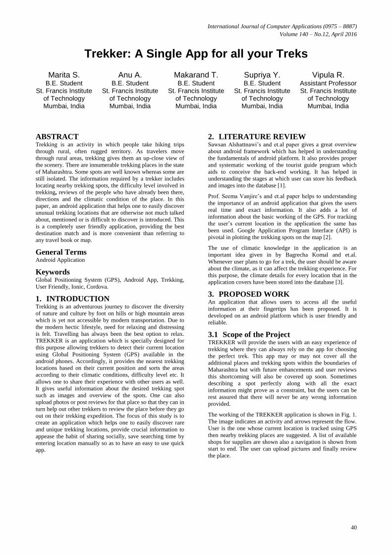
Following figures show the screenshots of the TREKKER
app. The register page is shown in Fig. 3 where the user must
enter the details to proceed. Once the user has registered
he/she is navigated to the login page as shown in Fig. 4. The
user then has to enter username and password. If the entered
username and the password are valid, the user is directed to
the home page as shown in Fig. 5. On clicking “Closest to
you” icon it leads to a pop up asking whether or not to allow
the GPS as shown in Fig. 6. Once the GPS is allowed it shows
the current location and nearby trekking spots. A trek place
can be chosen from a list of places as shown in Fig. 7 and
further details is shown on choosing the trek place leading to
Fig. 8. A map is shown Fig. 9 which gives navigation to the
trekking place chosen. Navigation details can be seen as
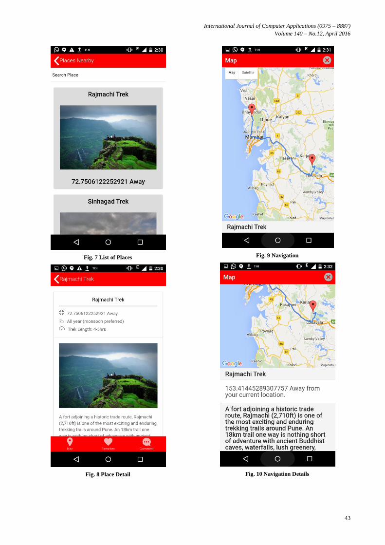
shown in Fig. 10. Reviews about the place can be uploaded as
shown in Fig. 11. Users can capture their memory in “My
Diary” as shown in Fig. 12.

International Journal of Computer Applications (0975 – 8887)
Volume 140 – No.12, April 2016
42
Fig. 3 Register Page
Fig. 4 Login Page
Fig. 5 Home Page
Fig. 6 Allow GPS
International Journal of Computer Applications (0975 – 8887)
Volume 140 – No.12, April 2016
43
Fig. 7 List of Places
Fig. 8 Place Detail
Fig. 9 Navigation
Fig. 10 Navigation Details
International Journal of Computer Applications (0975 – 8887)
Volume 140 – No.12, April 2016
44
Fig. 11 Comment about a Place
Fig. 12 My Diary
5. CONCLUSION AND FUTURE SCOPE Trekker is thus an application developed on the android
platform that basically lets the user choose from a list of
various trekking spots in Maharashtra. Once the user searches
for a particular spot, the user can view the navigation routes
that will make sure the user is always on the right track. The
main purpose of this app is to help the trekkers find all the
details vital for an enjoyable trekking trip in a single place
without surfing through several websites tediously. This app
is designed and developed using Ionic and Cordova and will
be supported by any Android device. Places outside
Maharashtra can also be included to increase the ease of usage
for the users thereby providing much wider and better scope
for the use of this application. The user interface is designed
so as to cater to all the needs of a trekker. It will be made sure
that the app is as user friendly as possible so that it can be
used by trekkers of all ages.
Currently, TREKKER which is developed using Ionic and
Cordova is compatible with Android platform. Further, it can
be extended to work on other operating systems such as iOS,
Windows and so on.
6. REFERENCES [1] Sawsan A., Amit B., Sneha C., Khivsara,” Building
Mobile Tourist Guide Applications using Different
Development Mobile Platforms” International Journal
of Advanced Science and Technology Vol. 54, May,
2013
[2] Prof. Seema V.,Unmesh K., Ganesh S., Pradnyesh P.
“Location Based Services on Smart Phone through the
Android Application” International Journal of Advanced
Research in Computer and Communication Engineering
Vol. 3, Issue 1, January 2014
[3] Bagrecha K., Amit B., Sneha, C., Khivsara,” Android
Application Using GPS Navigation”, 1st International
Conference on Recent Trends in Engineering &
Technology, Mar-2012 - Special Issue of International
Journal of electronics, Communication & Soft
Computing Science & Engineering, ISSN: 2277-9477
[4] Overview of Android Studio,
“http://developer.android.com/tools/studio/index.html” ,
November 28, 2015
[5] Node.js, “https://nodejs.org/en/about/” , January 3, 2016
[6] Overview, “https://cordova.apache.org/” , January 3,
2016
[7] Welcome to ionic, How to get most of Ionic,
“http://ionicframework.com/docs/guide/preface.html”,
January 10, 2016
[8] Cordova SQL Lite,
“http://ngcordova.com/docs/plugins/sqlite/”,January 10,
2016
[9] CordovaGPSPlugin,“http://ngcordova.com/docs/plugins/
geolocation/”,January 10, 2016
IJCATM : www.ijcaonline.org