trek mapping project year 2: a structural framework for ...€¦ · middle jurassic. it may be...
TRANSCRIPT
¯0 10 20 30 405
km
125°30'0"W
125°0'0"W
125°0'0"W
124°30'0"W
124°30'0"W
124°0'0"W
124°0'0"W
123°30'0"W
125°30'0"W
54°0'0"N
53°30'0"N53°30'0"N
53°0'0"N53°0'0"N
52°30'0"N
125°30'0"W
123°30'0"W
52°30'0"N
¯0 10 20 30 405
km
125°30'0"W
125°0'0"W
125°0'0"W
124°30'0"W
124°30'0"W
124°0'0"W
124°0'0"W
123°30'0"W
125°30'0"W
54°0'0"N
53°30'0"N53°30'0"N
53°0'0"N53°0'0"N
52°30'0"N
125°30'0"W
123°30'0"W
52°30'0"N
¯0 10 20 30 405
km
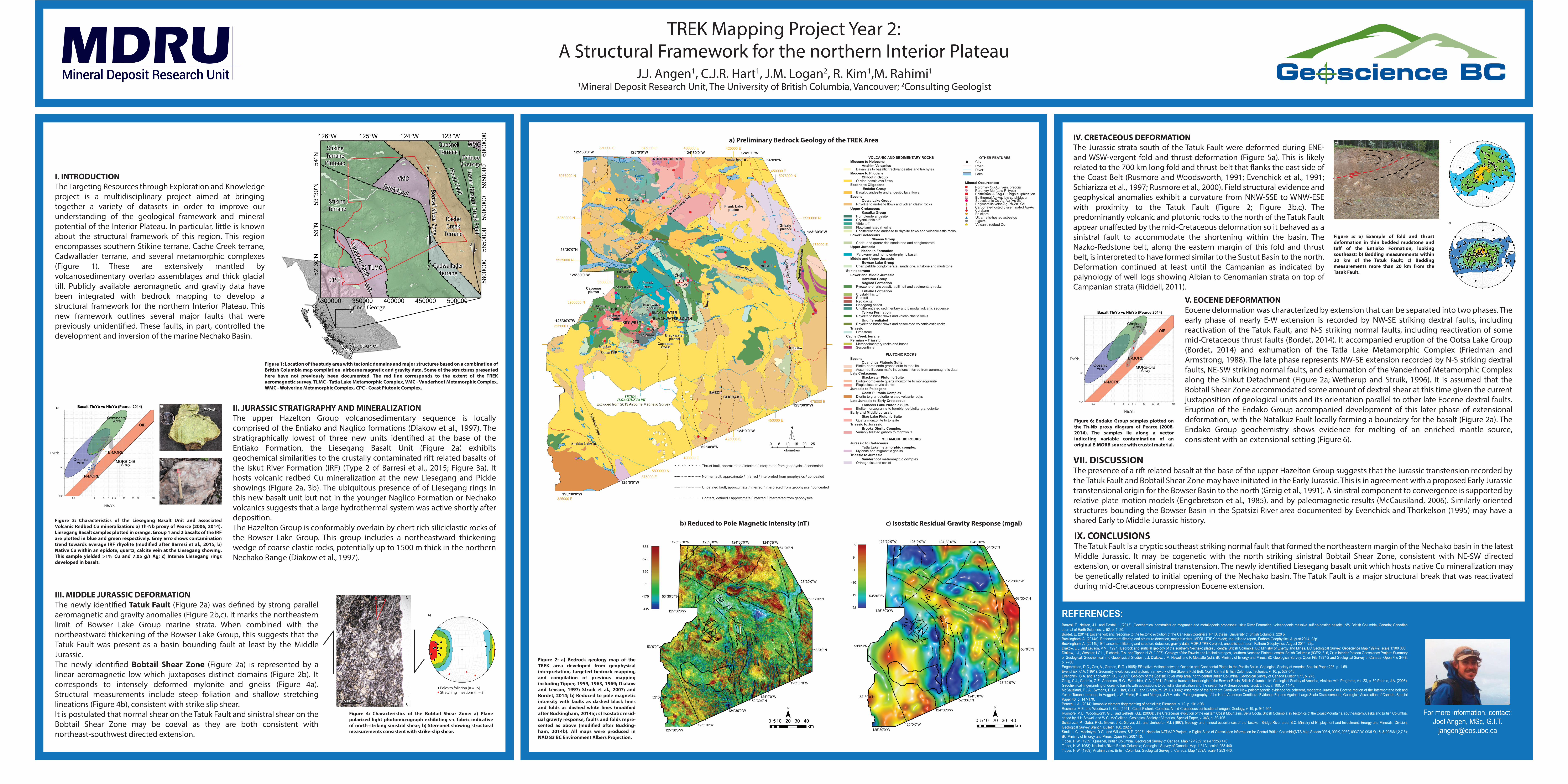
Figure 2: a) Bedrock geology map of the TREK area developed from geophysical interpretation, targeted bedrock mapping, and compilation of previous mapping including Tipper, 1959, 1963, 1969; Diakow and Levson, 1997; Struik et al., 2007; and Bordet, 2014; b) Reduced to pole magnetic intensity with faults as dashed black lines and folds as dashed white lines (modi�ed after Buckingham, 2014a); c) Isostatic resid-ual gravity response, faults and folds repre-sented as above (modi�ed after Bucking-ham, 2014b). All maps were produced in NAD 83 BC Environment Albers Projection.
TREK Mapping Project Year 2: A Structural Framework for the northern Interior Plateau
J.J. Angen1, C.J.R. Hart1, J.M. Logan2, R. Kim1,M. Rahimi1
1Mineral Deposit Research Unit, The University of British Columbia, Vancouver; 2Consulting Geologist
REFERENCES:Barresi, T., Nelson, J.L. and Dostal, J. (2015): Geochemical constraints on magmatic and metallogenic processes: Iskut River Formation, volcanogenic massive sulfide-hosting basalts, NW British Columbia, Canada; Canadian Journal of Earth Sciences, v. 52, p. 1–20.Bordet, E. (2014): Eocene volcanic response to the tectonic evolution of the Canadian Cordillera; Ph.D. thesis, University of British Columbia, 220 p.Buckingham, A. (2014a): Enhancement filtering and structure detection, magnetic data, MDRU TREK project; unpublished report, Fathom Geophysics, August 2014, 22p.Buckingham, A. (2014b): Enhancement filtering and structure detection, gravity data, MDRU TREK project; unpublished report, Fathom Geophysics, August 2014, 22p.Diakow, L.J. and Levson, V.M. (1997): Bedrock and surficial geology of the southern Nechako plateau, central British Columbia; BC Ministry of Energy and Mines, BC Geological Survey, Geoscience Map 1997-2, scale 1:100 000.Diakow, L.J., Webster, I.C.L., Richards, T.A. and Tipper, H.W. (1997): Geology of the Fawnie and Nechako ranges, southern Nechako Plateau, central British Columbia (93F/2, 3, 6, 7); in Interior Plateau Geoscience Project: Summary of Geological, Geochemical and Geophysical Studies, L.J. Diakow, J.M. Newell and P. Metcalfe (ed.), BC Ministry of Energy and Mines, BC Geological Survey, Open File 1997-2 and Geological Survey of Canada, Open File 3448, p. 7–30Engebretson, D.C., Cox, A., Gordon, R.G. (1985): ERelative Motions between Oceanic and Continental Plates in the Pacific Basin. Geological Society of America,Special Paper 206, p. 1-59. Evenchick, C.A. (1991): Geometry, evolution, and tectonic framework of the Skeena Fold Belt, North Central British Columbia; Tectonics, v. 10, p. 527-546.Evenchick, C.A. and Thorkelson, D.J. (2005): Geology of the Spatsizi River map area, north-central British Columbia; Geological Survey of Canada Bulletin 577, p. 276.Greig, C.J., Gehrels, G.E., Anderson, R.G., Evenchick, C.A. (1991): Possible transtensional origin of the Bowser Basin, British Columbia. In: Geological Society of America, Abstract with Programs, vol. 23, p. 30.Pearce, J.A. (2008): Geochemical fingerprinting of oceanic basalts with applications to ophiolite classification and the search for Archean oceanic crust; Lithos, v. 100, p. 14-48.McCausland, P.J.A., Symons, D.T.A., Hart, C.J.R., and Blackburn, W.H. (2006): Assembly of the northern Cordillera: New paleomagnetic evidence for coherent, moderate Jurassic to Eocene motion of the Intermontane belt and Yukon-Tanana terranes, in Haggart, J.W., Enkin, R.J. and Monger, J.W.H, eds., Paleogeography of the North American Cordillera: Evidence For and Against Large-Scale Displacements; Geological Association of Canada, Special Paper 46, p. 147-170.Pearce, J.A. (2014): Immobile element fingerprinting of ophiolites; Elements, v. 10, p. 101-108.Rusmore, M.E. and Woodsworth, G.L. (1991): Coast Plutonic Complex: A mid-Cretaceous contractional orogen; Geology, v. 19, p. 941-944.Rusmore, M.E., Woodsworth, G.L., and Gehrels, G.E. (2000): Late Cretaceous evolution of the eastern Coast Mountains, Bella Coola, British Columbia; in Tectonics of the Coast Mountains, southeastern Alaska and British Columbia, edited by H.H Stowell and W.C. McClelland. Geological Society of America, Special Paper, v. 343, p. 89-105.Schiarizza, P., Gaba, R.G., Glover, J.K., Garver, J.I., and Umhoefer, P.J. (1997): Geology and mineral occurrences of the Taseko - Bridge River area, B.C; Ministry of Employment and Investment, Energy and Minerals Division, Geological Survey Branch, Bulletin 100, 292 p.Struik, L.C., MacIntyre, D.G., and Williams, S.P. (2007): Nechako NATMAP Project: A Digital Suite of Geoscience Information for Central British Columbia(NTS Map Sheets 093N, 093K, 093F, 093G/W, 093L/9,16, & 093M/1,2,7,8); BC Ministry of Energy and Mines, Open File 2007-10.Tipper, H.W. (1959): Quesnel, British Columbia. Geological Survey of Canada, Map 12-1959; scale 1:253 440.Tipper, H.W. 1963): Nechako River, British Columbia; Geological Survey of Canada, Map 1131A; scale1:253 440.Tipper, H.W. (1969): Anahim Lake, British Columbia; Geological Survey of Canada, Map 1202A, scale 1:253 440.
I. INTRODUCTIONThe Targeting Resources through Exploration and Knowledge project is a multidisciplinary project aimed at bringing together a variety of datasets in order to improve our understanding of the geological framework and mineral potential of the Interior Plateau. In particular, little is known about the structural framework of this region. This region encompasses southern Stikine terrane, Cache Creek terrane, Cadwallader terrane, and several metamorphic complexes (Figure 1). These are extensively mantled by volcanosedimentary overlap assemblages and thick glacial till. Publicly available aeromagnetic and gravity data have been integrated with bedrock mapping to develop a structural framework for the northern Interior Plateau. This new framework outlines several major faults that were previously unidenti�ed. These faults, in part, controlled the development and inversion of the marine Nechako Basin.
IX. CONCLUSIONSThe Tatuk Fault is a cryptic southeast striking normal fault that formed the northeastern margin of the Nechako basin in the latest Middle Jurassic. It may be cogenetic with the north striking sinistral Bobtail Shear Zone, consistent with NE-SW directed extension, or overall sinistral transtension. The newly identi�ed Liesegang basalt unit which hosts native Cu mineralization may be genetically related to initial opening of the Nechako basin. The Tatuk Fault is a major structural break that was reactivated during mid-Cretaceous compression Eocene extension.
!H
!H
!HVictoriaVictoria
VancouverVancouver
Prince GeorgePrince George
4
44
4
4444
44444444
4 444
44
44
(((((((((((((((((((((((((((((((
((
((
(((
((((((((((
((((
(
(((((
(
(((((
4444
4
44
4444444
4444
4444
4444444444
4444444444444444444444444444444
444444
4444444444
4444
4
((((
((((
((((((((((((((((((((((
Prince GeorgePrince George
??
??
Tatuk FaultTatuk Fault
Pinchi FaultPinchi FaultFraser-Straight Creek FaultFraser-Straight Creek Fault
Bobtail Shear ZoneBobtail Shear Zone
Yalakom Fault
Yalakom Fault
Stikine TerraneStikine Terrane
TLMCTLMC
VMCVMC
Cache Creek
Terrane
Cache Creek
Terrane
Quesnel TerraneQuesnel Terrane
Cadwallader Terrane
Cadwallader Terrane
Stikine Terrane Plutonic
Stikine Terrane Plutonic
CPCCPC
WMCWMC
5
Figure 1: Location of the study area with tectonic domains and major structures based on a combination of British Columbia map compilation, airborne magnetic and gravity data. Some of the structures presented here have not previously been documented. The red line corresponds to the extent of the TREK aeromagnetic survey. TLMC - Tatla Lake Metamorphic Complex, VMC - Vanderhoof Metamorphic Complex, WMC - Wolverine Metamorphic Complex, CPC - Coast Plutonic Complex.
300000 350000 400000 450000 500000
5800
000
5850
000
5900
000
5950
000
6000
000125°W 123°W124°W126°W
54°N
53°3
0'N
53°N
52°3
0'N
III. MIDDLE JURASSIC DEFORMATIONThe newly identi�ed Tatuk Fault (Figure 2a) was de�ned by strong parallel aeromagnetic and gravity anomalies (Figure 2b,c). It marks the northeastern limit of Bowser Lake Group marine strata. When combined with the northeastward thickening of the Bowser Lake Group, this suggests that the Tatuk Fault was present as a basin bounding fault at least by the Middle Jurassic.The newly identi�ed Bobtail Shear Zone (Figure 2a) is represented by a linear aeromagnetic low which juxtaposes distinct domains (Figure 2b). It corresponds to intensely deformed mylonite and gneiss (Figure 4a). Structural measurements include steep foliation and shallow stretching lineations (Figure 4b), consistent with strike slip shear.It is postulated that normal shear on the Tatuk Fault and sinistral shear on the Bobtail Shear Zone may be coeval as they are both consistent with northeast-southwest directed extension.
Figure 4: Characteristics of the Bobtail Shear Zone: a) Plane polarized light photomicrograph exhibiting s-c fabric indicative of north-striking sinistral shear; b) Stereonet showing structural measurements consistent with strike-slip shear.
II. JURASSIC STRATIGRAPHY AND MINERALIZATIONThe upper Hazelton Group volcanosedimentary sequence is locally comprised of the Entiako and Naglico formations (Diakow et al., 1997). The stratigraphically lowest of three new units identi�ed at the base of the Entiako Formation, the Liesegang Basalt Unit (Figure 2a) exhibits geochemical similarities to the crustally contaminated rift related basalts of the Iskut River Formation (IRF) (Type 2 of Barresi et al., 2015; Figure 3a). It hosts volcanic redbed Cu mineralization at the new Liesegang and Pickle showings (Figure 2a, 3b). The ubiquitous presence of of Liesegang rings in this new basalt unit but not in the younger Naglico Formation or Nechako volcanics suggests that a large hydrothermal system was active shortly after deposition.The Hazelton Group is conformably overlain by chert rich siliciclastic rocks of the Bowser Lake Group. This group includes a northeastward thickening wedge of coarse clastic rocks, potentially up to 1500 m thick in the northern Nechako Range (Diakow et al., 1997).
V. EOCENE DEFORMATIONEocene deformation was characterized by extension that can be separated into two phases. The early phase of nearly E-W extension is recorded by NW-SE striking dextral faults, including reactivation of the Tatuk Fault, and N-S striking normal faults, including reactivation of some mid-Cretaceous thrust faults (Bordet, 2014). It accompanied eruption of the Ootsa Lake Group (Bordet, 2014) and exhumation of the Tatla Lake Metamorphic Complex (Friedman and Armstrong, 1988). The late phase represents NW-SE extension recorded by N-S striking dextral faults, NE-SW striking normal faults, and exhumation of the Vanderhoof Metamorphic Complex along the Sinkut Detachment (Figure 2a; Wetherup and Struik, 1996). It is assumed that the Bobtail Shear Zone accommodated some amount of dextral shear at this time given the current juxtaposition of geological units and its orientation parallel to other late Eocene dextral faults. Eruption of the Endako Group accompanied development of this later phase of extensional deformation, with the Natalkuz Fault locally forming a boundary for the basalt (Figure 2a). The Endako Group geochemistry shows evidence for melting of an enriched mantle source, consistent with an extensional setting (Figure 6).
For more information, contact:Joel Angen, MSc, G.I.T.
VII. DISCUSSIONThe presence of a rift related basalt at the base of the upper Hazelton Group suggests that the Jurassic transtension recorded by the Tatuk Fault and Bobtail Shear Zone may have initiated in the Early Jurassic. This is in agreement with a proposed Early Jurassic transtensional origin for the Bowser Basin to the north (Greig et al., 1991). A sinistral component to convergence is supported by relative plate motion models (Engebretson et al., 1985), and by paleomagnetic results (McCausiland, 2006). Similarly oriented structures bounding the Bowser Basin in the Spatsizi River area documented by Evenchick and Thorkelson (1995) may have a shared Early to Middle Jurassic history.
MORB-OIB Array
Oceanic Arcs
Continental Arcs
N-MORB
E-MORB
OIB
MOOO
Th/Yb
Nb/Yb
b)b)Native CuNative Cu
a)a)
c)c)
885
625
360
95
-170
-435
18
9
-1
-10
-19
-28
Figure 3: Characteristics of the Liesegang Basalt Unit and associated Volcanic Redbed Cu mineralization: a) Th-Nb proxy of Pearce (2006; 2014). Liesegang Basalt samples plotted in orange. Group 1 and 2 basalts of the IRF are plotted in blue and green respectively. Grey arro shows contamination trend towards average IRF rhyolite (modi�ed after Barresi et al., 2015; b) Native Cu within an epidote, quartz, calcite vein at the Liesegang showing. This sample yielded >1% Cu and 7.05 g/t Ag; c) Intense Liesegang rings developed in basalt.
b)b)
c)c)
a)a)IV. CRETACEOUS DEFORMATIONThe Jurassic strata south of the Tatuk Fault were deformed during ENE- and WSW-vergent fold and thrust deformation (Figure 5a). This is likely related to the 700 km long fold and thrust belt that �anks the east side of the Coast Belt (Rusmore and Woodsworth, 1991; Evenchick et al., 1991; Schiarizza et al., 1997; Rusmore et al., 2000). Field structural evidence and geophysical anomalies exhibit a curvature from NNW-SSE to WNW-ESE with proximity to the Tatuk Fault (Figure 2; Figure 3b,c). The predominantly volcanic and plutonic rocks to the north of the Tatuk Fault appear una�ected by the mid-Cretaceous deformation so it behaved as a sinistral fault to accommodate the shortening within the basin. The Nazko-Redstone belt, along the eastern margin of this fold and thrust belt, is interpreted to have formed similar to the Sustut Basin to the north. Deformation continued at least until the Campanian as indicated by palynology of well logs showing Albian to Cenomanian strata on top of Campanian strata (Riddell, 2011).
MORB-OIB Array
Oceanic Arcs
Continental Arcs
N-MORB
E-MORB
OIBss
EEEEEEE-MM
nennnneeeAAArrcccsss
eeennnttsss
Th/Yb
Nb/Yb
C S N
S500 um500 um
a)a)
Figure 6: Endako Group samples plotted on the Th-Nb proxy diagram of Pearce (2008, 2014). The samples lie along a vector indicating variable contamination of an original E-MORB source with crustal material.
Figure 5: a) Example of fold and thrust deformation in thin bedded mudstone and tu� of the Entiako Formation, looking southeast; b) Bedding measurements within 20 km of the Tatuk Fault; c) Bedding measurements more than 20 km from the Tatuk Fault.
Poles to foliation (n = 15)Stretching lineations (n = 3)
b)b)
METAMORPHIC ROCKS
Jurassic to Paleogene
Early and Middle Jurassic
Late Jurassic to Early Cretaceous
Late Cretaceous
Triassic to Jurassic
Triassic to Jurassic
Blackwater Plutonic Suite
Coast Plutonic Complex
Francois Lake Plutonic Suite
Stag Lake Plutonic Suite
Jurassic to Cretaceous
Eocene
Vanderhoof metamorphic complex
Tatla Lake metamorphic complex
PLUTONIC ROCKS
Brooks Diorite Complex
Orthogneiss and schist
Assumed Eocene mafic intrusions inferred from aeromagnetic data
Biotite-hornblende quartz monzonite to monzogranitePlagioclase-phyric diorite
Diorite to granodiorite related volcanic rocks
Biotite monzogranite to hornblende-biotite granodiorite
Quartz monzonite to tonalite
Variably foliated gabbro to monzonite
Mylonite and migmatitic gneiss
Serpentinite
Biotite-hornblende granodiorite to tonalite
VOLCANIC AND SEDIMENTARY ROCKS
Miocene to PlioceneChilcotin Group
Miocene to HoloceneAnahim Volcanics
Eocene to Oligocene Endako Group
EoceneOotsa Lake Group
Upper JurassicNechako Formation
Upper CretaceousKasalka Group
Telkwa Formation
Stikine terraneLower and Middle Jurassic
Hazelton Group
Entiako Formation
Undifferentiated
Naglico Formation
Bowser Lake GroupMiddle and Upper Jurassic
Cache Creek terranePermian – Triassic
Triassic
Lower CretaceousSkeena Group
Pyroxene- and hornblende-phyric basalt
Olivine basalt lava flows
Basaltic andesite and andesitic lava flows
Rhyolite to andesite flows and volcaniclastic rocks
Undifferentiated andesite to rhyolite flows and volcaniclastic rocks
Chert pebble conglomerate, sandstone, siltstone and mudstone
Pyroxene-phyric basalt, lapilli tuff and sedimentary rocks
Undifferentiated sedimentary and bimodal volcanic sequence
Rhyolite to basalt flows and volcaniclastic rocks
Rhyolite to basalt flows and associated volcaniclastic rocks
Limestone
Metasedimentary rocks and basalt
Chert- and quartz-rich sandstone and conglomerate
Basanites to basaltic trachyandesites and trachytes
Quanchus Plutonic Suite
Hornblende andesiteCrystal-lithic tuffVitric tuffFlow-laminated rhyolite
Crystal-lithic tuffRed tuffRed daciteLiesegang basalt
! CityOTHER FEATURES
RoadRiverLake
GF Lignite
$+Carbonate-hosted disseminated Au-Ag
") Epithermal Au-Ag-Cu: high sulphidation") Epithermal Au-Ag: low sulphidation
!( Porphyry Cu-Au: vein, breccia
$+
Polymetallic veins Ag-Pb-Zn+/-AuXW
Cu skarn
XW
Fe skarn
'' Subvolcanic Cu-Ag-Au (As-Sb)
!( Porphyry Mo (Low F- type)
#* Ultramafic-hosted asbestos
Mineral Occurrences
Volcanic redbed Cu
a) Preliminary Bedrock Geology of the TREK Area
b) Reduced to Pole Magnetic Intensity (nT) c) Isostatic Residual Gravity Response (mgal)
425000 E
!
!
!
!(
!(!(
")
")
")")
!(
")!(
")
!(!(!(
")!(!(
#*
")
")!(
") ")
")
")
!(!(
")
") ")")!(")") ")
#*
")GF
!( !(!( !(
!(!( !(!(!(!( !(!(!(!( !(!(
!(!(
!(
''
!(
")
Knewstu
bb Lake
Knewstu
bb Lake
FrancoisFrancois LakeLake
NechakoNechako ReservoirReservoir
CabinLakeCabinLake
VanderhoofVanderhoof
Anahim LakeAnahim Lake
NazkoNazko
Yalakom Fault
44
44
4
4
444
44
444
44
44
44
444
44
4
((
(
(
((
((
44
4
44
44
44
44
44
44
44
44
44
44
44
44
((
(
4 4
44 4 444
44444
(
(
(
(
(
((
((
&
(
(
(
(
((
(
((
(
4
44
44
44
44
4
4
4
4
4
4
4
4
444444444444
44
444
444
444444
44
44444444
4
44
4
44
4
4
4
44
444
44
4
44
44
44
44
44
44
444
44
44
44
44
44
44
44
44
44
444
44
44
44
4
4
44
44
44
44
4
44
44
44
4444
44
44
4
44
44
44
44
44
44
44
44
44
4
44
4
444
44
44
44
44
44
44
44
44
44
44
44
4
44
44444444444444
44
44
44
44
44
4
4
44
44
44
4
44
4
4 4
44
4
44
44
44
44
44
44
44
44
44
44
44
44
4
44
44
44
44
44
44
44
44
44
4
44
44
44
44
44
44
44
44
44
44
44
44
4
444
44
4
4
44
44
44
44
44
4
4
4
44
44
44
444
4
4
44
444
44444444444444
44
44
44
44444
444444444
4
4444
4
444
44
44
44
44
44
44
4
4
4
4
44
44
4
44
44
44
44
4
4
4
44
44
4444
444
4
44
4
4
4
4
(
4
44
44
44
4
4
4
44
44
4
4
4
44
44
44
4
4
(
44
44
44
4
4
(
4
44
CLISBAKOCLISBAKOBAEZBAEZ
3TS3TS
BLACKWATERBLACKWATER
CAPOOSECAPOOSE
CHUCHU
HOLY CROSSHOLY CROSS
NITHINITHI MOUNTAINMOUNTAIN
ITCHA -ITCHA -ILGACHUZ PARKILGACHUZ PARK
Excluded from 2013 Airborne Magnetic SurveyExcluded from 2013 Airborne Magnetic Survey
325000 E
325000 E
350000 E
375000 E
375000 E
400000 E
400000 E
425000 E
450000 E
450000 E
475000 E
475000 E
5800000 N
5900000 N
5925000 N
5950000 N 5950000 N
5975000 N 5975000 N
350000 E
125°30'0"W
125°30'0"W
125°0'0"W
125°0'0"W
124°0'0"W
124°0'0"W
123°30'0"W
125°30'0"W
54°0'0"N
53°30'0"N
123°30'0"W
125°30'0"W
52°30'0"N
124°30'0"W
$+
BLACKWATER SOUTHBLACKWATER SOUTH
KEYKEY
KEY WESTKEY WEST
HAVANAHAVANA
LIESEGANGLIESEGANGPICKLEPICKLE
XW
KluskusKluskusMalaput FSRMalaput FSR
KluskusKluskus
Ootsa FSROotsa FSR
Access RdAccess RdBlackwaterBlackwater Bl
ue F
SRBl
ue F
SR
Kenney Dam FSR
Kenney Dam FSR
LaidmanbatholithLaidmanbatholith
Capoosepluton
Capoosepluton
Blackwaterpluton
Blackwaterpluton
Capoosestock
Capoosestock
Frank Lakepluton
Frank Lakepluton
GrizzlyplutonGrizzlypluton
CHpluton
CHpluton
44
((
4 4
( (
4 4
( (
4 4
( (
Undefined fault, approximate / inferred / interpreted from geophysics / concealed
Contact, defined / approximate / inferred / interpreted from geophysics
Normal fault, approximate / inferred / interpreted from geophysics / concealed
Thrust fault, approximate / inferred / interpreted from geophysics / concealed
kilometres
0 5 10 15 20 25
N
FawnieDome
FawnieDome
GG
Natalkuz Fault
Natalkuz Fault
Sink
ut D
etac
hmen
tSi
nkut
Det
achm
ent
Bobtail Shear ZoneBobtail Shear Zone
Tatuk FaultTatuk Fault