tree preservation order - west-dunbarton.gov.uk · tree preservation order register ... wdc 11...
TRANSCRIPT

TREE PRESERVATION ORDER REGISTER
March 2011
Trees and woodlands form an important component of both the urban and rural landscape in West Dunbartonshire. They contribute to the general appearance and amenity of the area, and their removal can therefore have a significant impact. The Town and County Planning (Scotland) Act 1997 gives planning authorities the power to make a tree preservation order (TPO) in respect of trees or woodlands if it is considered to be in the interest of amenity. A TPO prohibits the cutting down, uprooting, topping, lopping, wilful damage or destruction of trees without the Council’s consent. There are 50 separate TPOs in place across West Dunbartonshire, covering over 365 hectares of woodland, individual trees and groups of trees. The first TPO was confirmed in West Dunbartonshire in the 1950s by Dunbartonshire County Council. This Register lists details of all the TPOs within West Dunbartonshire, by the authority which made the Order. For further details about Tree Preservation Orders in West Dunbartonshire please contact: Planning & Building Standards Aurora House 3 Aurora Avenue Clydebank G81 1BF Telephone: 0141 951 7930 Email: [email protected]
Note: this document does not apply to the Loch Lomond & The Trossachs National Park area.

2
TREE PRESERVATION ORDER REGISTER October 2010
TPO No. Location Year
DCC 2 Vale of Leven East 1952
DCC 12 Mirren Drive, Hardgate 1972
DCC 23 Overton Road/Smollet Road, Alexandria 1974
CBC 1 Glenhead Road, Clydebank 1972
CBC 2 Clydebank Golf Course 1974
DBC 1 Stirling Road, Dumbarton 1965
DBC 2 Dunmore, Dumbarton 1975
CDC 1 Braidfield School 1980
CDC 5 Kilpatrick Braes 1975
CDC 6 North Douglas St, John Knox St, North Bank St & Glasgow Rd 1980
CDC 7 Auchentoshan 1983
CDC 8 Duntocher House, Clydebank 1983
CDC 11 ‘Drums’, Old Kilpatrick 1988
CDC 12 Dalnottar House, Old Kilpatrick 1988
CDC 13 ‘Glenlee’, Risk Street, Dalmuir 1988
CDC 14 Dunholme House, Dalmuir 1989
CDC 15 Cochno Rd, Hardgate 1989
CDC 17 Roman Rd, Duntocher 1990
CDC 18 Mountblow 1993
CDC 19 Dumbarton Road, Dalmuir West 1993
CDC 20 ‘Dunclutha’, Parkhall Rd 1993
CDC 21 Whitecrook, Clydebank 1993
CDC 22 16 Burncrooks Court, Clydebank 1994
CDC 23 Edinbarnet Home, Clydebank 1994
CDC 24 Cochno House Estate 1994
DDC 1 Milton 1975
DDC 2 Gavinburn, Bowling 1978
DDC 3 Riverside Church, Dumbarton 1977
DDC 6 Dillichip, Bonhill 1978
DDC 13 Riverside Inn Dalvait Road, Balloch 1986
DDC 14 Dalmoak, Renton 1983
DDC 19 Keil School, Dumbarton 1983
DDC 36 Dalquhurn, Renton 1987
DDC 37 Bellfield, Dumbarton 1987
DDC 38A Barnhill, Milton 1988
DDC 43 Milton Brae, Milton 1990
DDC 49 Vale of Leven Industrial Estate 1995
DDC 54 Convent of Notre Dame, Dumbarton 1994
WDC 1 Methlan Park, Dumbarton 1998
WDC 2 Dumbuck Bowling Club, Dumbarton 1998
WDC 3 ‘Craigard’, Upper Bridge St, Alexandria 1998
WDC 4 Levenbank Terrace, Jamestown 2002
WDC 5 Vale of Leven Hospital, Alexandria 2002
WDC 6 Round Riding Road, Dumbarton 2002
WDC 7 Auchentoshan Woods, Clydebank 2002
WDC 8 Cables Drive, Dalmonach 2007
WDC 9 Overtoun Avenue and Silverton Avenue, Dumbarton 2008
WDC 10 Islay Kerr House & 12 Kirkton Road, Dumbarton 2003
WDC 11 Edinbarnet Wood 2010
WDC 12 Rockbank Place, Hardgate 2010

3
Tree preservation orders approved by County Council of Dumbartonshire (DCC). 1947 – 15th May 1975
Tree preservation orders approved by Clydebank Burgh Council (CBC). 1947 – 15th May 1975
Tree preservation orders approved by Dumbarton Burgh Council (DBC). 1947 – 15th May 1975
Tree preservation orders approved by Clydebank District Council (CDC).
15th May 1975 – 1st April 1996
Tree preservation orders approved by Dumbarton District Council (DDC). 15th May 1975 – 1st April 1996
Tree preservation orders approved by West Dunbartonshire Council (WDC). 1st April 1996 – Present

4
Dumbarton County Council TPO 2 Tree Preservation Order No.2 - Registered by Dumbarton County Council
Name Vale of Leven, East Date of Execution 4th May 1951 Date of Confirmation 20th February 1952 Land Affected Bonhill East, includes Broomhill and Beechwood Area Affected 28.36 ha Tree Species Various
DCCTPO1 Scale 1:20000 OS Ref: NS 407 8NE
5
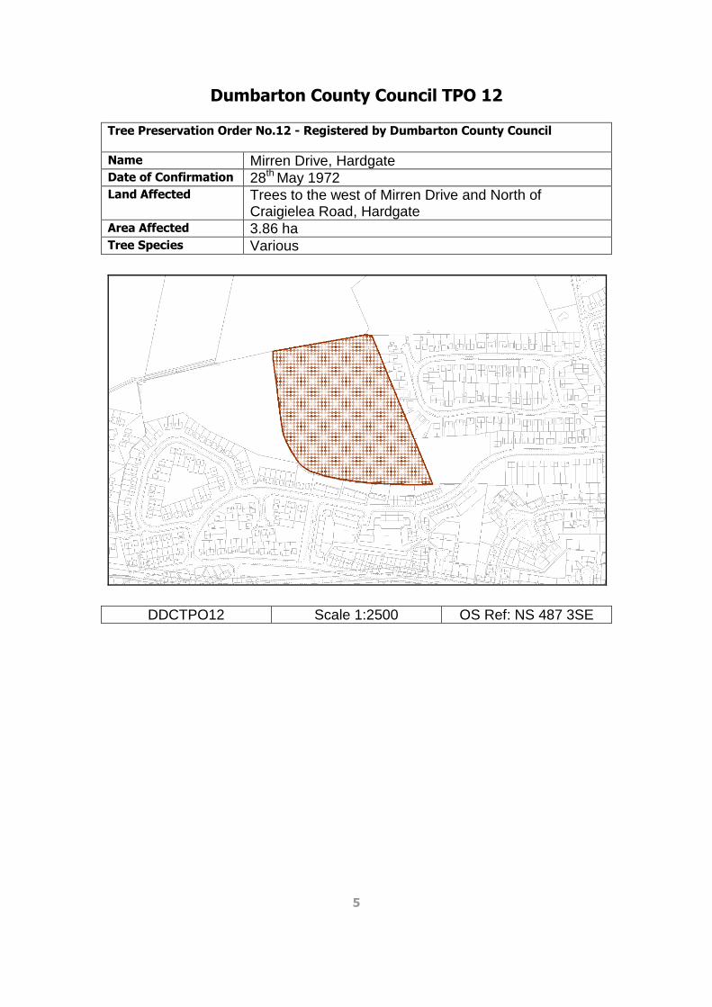
Dumbarton County Council TPO 12 Tree Preservation Order No.12 - Registered by Dumbarton County Council
Name Mirren Drive, Hardgate Date of Confirmation 28th May 1972 Land Affected Trees to the west of Mirren Drive and North of
Craigielea Road, Hardgate Area Affected 3.86 ha Tree Species Various
DDCTPO12 Scale 1:2500 OS Ref: NS 487 3SE
6
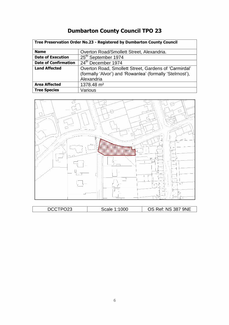
Dumbarton County Council TPO 23 Tree Preservation Order No.23 - Registered by Dumbarton County Council
Name Overton Road/Smollett Street, Alexandria. Date of Execution 25th September 1974 Date of Confirmation 24th December 1974 Land Affected Overton Road, Smollett Street, Gardens of ‘Carmirdal’
(formally ‘Alvor’) and ‘Rowanlea’ (formally ‘Stelrnost’), Alexandria
Area Affected 1378.48 m² Tree Species Various
DCCTPO23 Scale 1:1000 OS Ref: NS 387 9NE

7
Clydebank Burgh Council TPO 1 Tree Preservation Order No.1 - Registered by Clydebank Burgh Council
Name Glenhead Road, Clydebank Date of Confirmation 17th October 1972. Land Affected Land to East of 9 Glenhead Road containing 4 no. trees Area Affected Tree Species A: Lime, B: Beech, C: Oak, D: Lime
CBCTPO1 Scale 1:1250 OS Ref: NS 497 2SW

8
Clydebank Burgh Council TPO 2 Tree Preservation Order No.2 - Registered by Clydebank Burgh Council
Name Clydebank Golf Course Date of Confirmation 11th February 1974 Land Affected Clydebank District Golf Course, south of the A810 Area Affected 76.19 ha Tree Species Various
CBCTPO2 Scale 1:5000 OS Ref: NS 507 2NE

9
Dumbarton Burgh Council TPO 1 Tree Preservation Order No.1 - Registered by Dumbarton Burgh Council
Name Stirling Road, Dumbarton Date of Execution 4th May 1965 Date of Confirmation 2nd July 1965 Land Affected 11 no. individual trees and 2 no. areas between
Mansewood Drive and Stirling Road, Dumbarton Area Affected 303.87 m² Tree Species Various
DBCTPO1 Scale 1:1000 OS Ref: NS 407 6SE

10
Dumbarton Burgh Council TPO 2 Tree Preservation Order No.2 - Registered by Dumbarton Burgh Council
Name Dunmore, Dumbarton Date of Confirmation 8th October 1975 Land Affected Gardens of Helenslee Court (formally Dunmore),
Helenslee Road, Kirktonhill, Dumbarton. Area Affected 1.05 ha Tree Species Various
DBCTPO2 Scale 1:1250 OS Ref: NS 387 5SE

11
Clydebank District Council TPO 1 Tree Preservation Order No.1 - Registered by Clydebank District Council
Name Braidfield School Date of Confirmation 4th February 1980 Land Affected West of Braidfield School playing fields; north of
Kilbowie cemetery Area Affected 6846.4 m² Tree Species Various
CDCTPO1 Scale 1:2000 OS Ref: NS 507 0NW

12
Clydebank District Council TPO 5 Tree Preservation Order No.5 - Registered by Clydebank District Council
Name Kilpatrick Braes Date of Confirmation 19th September 1975 Land Affected Kilpatrick Braes, lying north of Great Western Road and
west of Gavinburn Farm. Includes areas previously designated as Clydebank District Council TPO4.
Area Affected 49.09 ha Tree Species Various
CDCTPO5 Scale 1:7500 OS Ref: NS 467 3NW
13
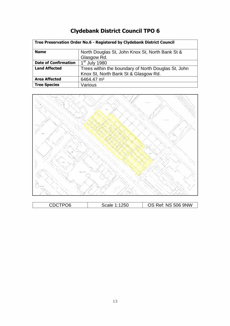
Clydebank District Council TPO 6 Tree Preservation Order No.6 - Registered by Clydebank District Council
Name North Douglas St, John Knox St, North Bank St & Glasgow Rd.
Date of Confirmation 1st July 1980 Land Affected Trees within the boundary of North Douglas St, John
Knox St, North Bank St & Glasgow Rd. Area Affected 6464.47 m² Tree Species Various
CDCTPO6 Scale 1:1250 OS Ref: NS 506 9NW

14
Clydebank District Council TPO 7 Tree Preservation Order No.7 - Registered by Clydebank District Council
Name Auchentoshan Date of Confirmation 4th August 1983 Land Affected Trees within the grounds of Auchentoshan School and
Auchentoshan Occupational Centre Area Affected 11.35 ha Tree Species Various
CDCTPO7 Scale 1:2000 OS Ref: NS 487 2NW

15
Clydebank District Council TPO 8 Tree Preservation Order No.8 - Registered by Clydebank District Council
Name Duntocher House Date of Confirmation 24th October 1983 Land Affected Trees to the north of Old Mill Road and west of Roman
Road, Duntocher Area Affected 1.22 ha Tree Species Various
CDCTPO8 Scale 1:1250 OS Ref: NS 497 2NW

16
Clydebank District Council TPO 9/10/14 Tree Preservation Order No.9/10/14 - Registered by Clydebank District Council
Name Dunholme House, Dalmuir Date of Confirmation 14th December 1984 / 9th August 1984 / 27th April 1989 Land Affected Trees east of Farm Road and Durban Avenue, Dalmuir;
south of Dumbarton Road Area Affected 1.14 ha Tree Species Various
CDCTPO9/10/14 Scale 1:2000 OS Ref: NS 477 1SE

17
Clydebank District Council TPO 11 Tree Preservation Order No.11 - Registered by Clydebank District Council
Name ‘Drums’, Old Kilpatrick Date of Confirmation 25th March 1988 Land Affected Trees surrounding ‘Drums’, Old Kilpatrick, north west of
Mount Pleasant Farm Area Affected 2.78 ha Tree Species Various
CDCTPO11 Scale 1:5000 OS Ref: NS 467 3NE
18
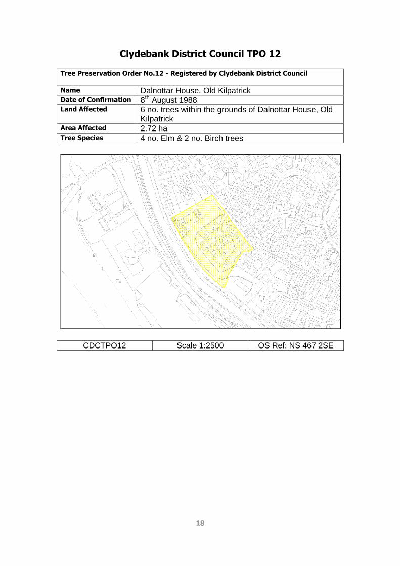
Clydebank District Council TPO 12 Tree Preservation Order No.12 - Registered by Clydebank District Council
Name Dalnottar House, Old Kilpatrick Date of Confirmation 8th August 1988 Land Affected 6 no. trees within the grounds of Dalnottar House, Old
Kilpatrick Area Affected 2.72 ha Tree Species 4 no. Elm & 2 no. Birch trees
CDCTPO12 Scale 1:2500 OS Ref: NS 467 2SE

19
Clydebank District Council TPO 13 Tree Preservation Order No.13 - Registered by Clydebank District Council
Name ‘Glenlee’, Risk St, Dalmuir Date of Confirmation 7th November 1988. Land Affected Trees within grounds of ‘Glenlee’, Risk Street Area Affected 1229.15 m² Tree Species Various
CDCTPO13 Scale 1:1000 OS Ref: NS 487 1NE

20
Clydebank District Council TPO 15 Tree Preservation Order No.15 - Registered by Clydebank District Council
Name Glasgow Road & Cochno Road, Hardgate Date of Confirmation 27th April 1989. Land Affected Trees at Glasgow Road and Cochno Road; Goldenhill
Public House Car Park Area Affected 1310.34 m² Tree Species Various
CDCTPO15 Scale 1:1000 OS Ref: NS 497 2NE
21
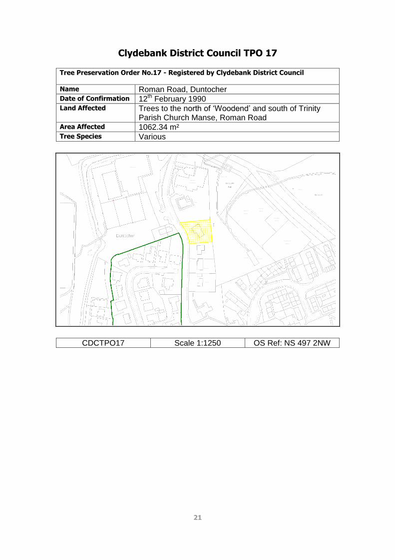
Clydebank District Council TPO 17 Tree Preservation Order No.17 - Registered by Clydebank District Council
Name Roman Road, Duntocher Date of Confirmation 12th February 1990 Land Affected Trees to the north of ‘Woodend’ and south of Trinity
Parish Church Manse, Roman Road Area Affected 1062.34 m² Tree Species Various
CDCTPO17 Scale 1:1250 OS Ref: NS 497 2NW

22
Clydebank District Council TPO 18 Tree Preservation Order No.18 - Registered by Clydebank District Council
Name Mountblow Date of Confirmation 26th March 1993 Land Affected Trees at 5 sites in Mountblow:
A. Mountblow House, Melbourne Avenue B. Junction of Melbourne Avenue & Salisbury Place C. Driveway of Montreal House D. Garden of No. 85 Kimberley Street E. Garden of No. 47 Kimberley Street, corner of
Hobart Crescent F. Area covering Myrtle Road, Lilac Avenue, Cedar
Avenue, Pine Road & Laurel Avenue (includes 2 no. trees previously designated as Clydebank District Council TPO16 - Cedar Avenue, Dalmuir).
Area Affected 5.28 ha Tree Species Various
CDCTPO18 Scale 1:5000 OS Ref: NS 477 2SE

23
Clydebank District Council TPO 19 Tree Preservation Order No.19 - Registered by Clydebank District Council
Name Dalmuir West Date of Confirmation 12th March 1993 Land Affected Trees along Dumbarton Road from Dalnottar Park
roundabout to Mountblow Road junction Area Affected 2.33 ha Tree Species Various
CDCTPO19 Scale 1:5000 OS Ref: NS 477 1NE

24
Clydebank District Council TPO 20 Tree Preservation Order No.20 - Registered by Clydebank District Council
Name ‘Dunclutha’, Parkhall Road Date of Confirmation 12th March 1993 Land Affected Trees within the grounds of ‘Dunclutha’, Parkhall Road Area Affected 2775.84 m² Tree Species Various
CDCTPO20 Scale 1:1250 OS Ref: NS 487 1NE

25
Clydebank District Council TPO 21 Tree Preservation Order No.21 - Registered by Clydebank District Council
Name Whitecrook Date of Confirmation 7th April 1993 Land Affected Trees along various roads in Whitecrook and the
grounds of Whitecrook Nursery: Abbott Crescent, Aberconway Street, Andrew Drive, Barns Street, Bell Street, Cochno Street, East Barns Street, Flemming Avenue, Johnston Avenue, McDonald Crescent, McGregor Street, Millbrae Crescent, Mill Road, Taylor Street & White Street
Area Affected 6.11 ha Tree Species Various
CDCTPO21 Scale 1:5000 OS Ref: NS 506 9NE

26
Clydebank District Council TPO 22 Tree Preservation Order No.22 - Registered by Clydebank District Council
Name 16 Burncrooks Court Date of Confirmation 14th July 1994 Land Affected 1 no. Sycamore tree within the boundary of 16
Burncrooks Court Area Affected 197.94 m² Tree Species Sycamore
CDCTPO22 Scale 1:500 OS Ref: NS 487 2NE

27
Clydebank District Council TPO 23 Tree Preservation Order No.23 - Registered by Clydebank District Council
Name Edinbarnet Home Date of Confirmation 28th June 1994 Land Affected Trees within the grounds of Edinbarnet Nursing Home Area Affected 4.15 ha Tree Species Various
CDCTPO23 Scale 1:2500 OS Ref: NS 507 4SE

28
Clydebank District Council TPO 24 Tree Preservation Order No.24 - Registered by Clydebank District Council
Name Cochno House Estate Date of Confirmation 28th June 1994 Land Affected Area of trees of various species located on the Cochno
House Estate, Old Kilpatrick Area Affected 109.25 ha Tree Species Various
CDCTPO24 Scale 1:10000 OS Ref: NS 497 4SE

29
Dumbarton District Council TPO 1
Tree Preservation Order No.1 - Registered by Dumbarton District Council
Name Milton Date of Execution 25th June 1975 Date of Confirmation 16th October 1975 Land Affected 7 Areas around Milton as well as 10 individual trees
around Milton Hill and Sturgan House Area Affected 18.85 ha Tree Species Various
DDCTPO1 Scale 1:7500 OS Ref: NS 427 4NE

30
Dumbarton District Council TPO 2 Tree Preservation Order No.2 - Registered by Dumbarton District Council
Name Gavinburn, Bowling Date of Execution 26th May 1976 Date of Confirmation 13th January 1978 Land Affected Gavinburn Farm, Bowling. Area stretching from A82 in
the south to Loch Humphrey in the north. Area Affected 15.12 ha Tree Species Various
DDCTPO2 Scale 1:15000 OS Ref: NS 477 5NE

31
Dumbarton District Council TPO 3 Tree Preservation Order No.3 - Registered by Dumbarton District Council
Name Riverside Church, Dumbarton Date of Execution 25th August 1976 Date of Confirmation 28th June 1977 Land Affected Grounds of Riverside Church, High Street & Castle
Street, Dumbarton Area Affected 3070.43 m² Tree Species Various
DDCTPO3 Scale 1:1250 OS Ref: NS 397 5NE

32
Dumbarton District Council TPO 6 Tree Preservation Order No.6 - Registered by Dumbarton District Council
Name Dillichip, Bonhill Date of Confirmation 27th June 1978 Land Affected Area east of the Warehouses on the Leven Meander,
Dillichip Loan, Bonhill. Area Affected 1.12 ha Tree Species Various
DDCTPO6 Scale 1:2000 OS Ref: NS 397 9SW

33
Dumbarton District Council TPO 13 Tree Preservation Order No.13 - Registered by Dumbarton District Council
Name Riverside Inn, Dalvait Road, Balloch Date of Execution 25th March 1986 Date of Confirmation 24th June 1986 Land Affected Grounds of the former Lennoxbank Hotel, Dalvait
Road, Balloch Area Affected 688.91 m² Tree Species Various
DDCTPO13 Scale 1:1250 OS Ref: NS 398 1SW

34
Dumbarton District Council TPO 14 Tree Preservation Order No.14 - Registered by Dumbarton District Council
Name Dalmoak Date of Execution 27th September 1983 Date of Confirmation 29th December 1983 Land Affected Trees along driveway to Dalmoak House, Renton
Road, Dumbarton Area Affected 1.68 ha Tree Species Various
DDCTPO14 Scale 1:2500 OS Ref: NS 387 6NW

35
Dumbarton District Council TPO 19 Tree Preservation Order No.19 - Registered by Dumbarton District Council
Name Keil School, Dumbarton Date of Execution 23rd February 1982 Date of Confirmation 29th December 1983 Land Affected Trees within the grounds of Keil School, Dumbarton Area Affected 11.30 ha Tree Species Various
DDCTPO19 Scale 1:5000 OS Ref NS387 5SE

36
Dumbarton District Council TPO 36 Tree Preservation Order No.36 - Registered by Dumbarton District Council
Name Dalquhurn, Renton Date of Confirmation 22nd October 1986 Land Affected Trees along western boundary of Dalquhurn Trading
Estate, Renton Area Affected 7304.05 m² Tree Species Various
DDCTPO36 Scale 1:2000 OS Ref: NS 387 7NE

37
Dumbarton District Council TPO 37 Tree Preservation Order No.37 - Registered by Dumbarton District Council
Name Bellfield, Dumbarton Date of Confirmation 22nd July 1987 Land Affected Trees within the garden grounds of 37 & 37A Oxhill
Road, 19-25 (odd nos. only) and 20-54 (even nos. only) Helenslee Crescent, Dumbarton
Area Affected 8683.68 m² Tree Species Various
DDCTPO37 Scale 1:1250 OS Ref: NS 387 5SE

38
Dumbarton District Council TPO 38A Tree Preservation Order No.38A - Registered by Dumbarton District Council
Name Barnhill, Milton Date of Confirmation 3rd March 1988 Land Affected 4 areas encompassing 40 no. Scots Pine trees at
Barnhill, Milton Brae, Milton: A: Scots Pine nos. 1-7 B: Scots Pine nos. 9-30 C: Scots Pine nos. 31-34 D: Scots Pine nos. 35-40 Supersedes Dumbarton District Council TPO No. 38
Area Affected 4663.69 m² Tree Species Scots Pine
DDCTPO38A Scale 1:2500 OS Ref: NS 427 5SW

39
Dumbarton District Council TPO 43 Tree Preservation Order No.43 - Registered by Dumbarton District Council
Name Milton Brae, Milton Date of Execution 31st August 1990 Date of Confirmation 29th November 1990 Land Affected Trees at Milton Brae & Milton Hill, Milton Area Affected 7734.87 m² Tree Species Various
DDCTPO43 Scale 1:1250 OS Ref: NS 427 4SE

40
Dumbarton District Council TPO 49 Tree Preservation Order No.49 - Registered by Dumbarton District Council
Name Vale of Leven Industrial Estate, Bonhill Date of Execution 11th May 1995 Date of Confirmation 13th July 1995 Land Affected Single Pollarded Sessile Oak situated south–west of
Strathleven House, Vale of Leven Industrial Estate, Bonhill
Area Affected Tree Species Sessile Oak
DDCTPO49 Scale 1:1250 OS Ref: NS 397 7NE

41
Dumbarton District Council TPO 54 Tree Preservation Order No.54 - Registered by Dumbarton District Council
Name Convent of Notre Dame, Dumbarton Date of Execution 25th November 1993 Date of Confirmation 19th April 1994 Land Affected Avenue of trees on approach road to the Convent of
Notre Dame, Cardross Road, Dumbarton Area Affected 1230.4 m² Tree Species Various
DDCTPO54 Scale 1:1250 OS Ref: NS 387 5NW
42
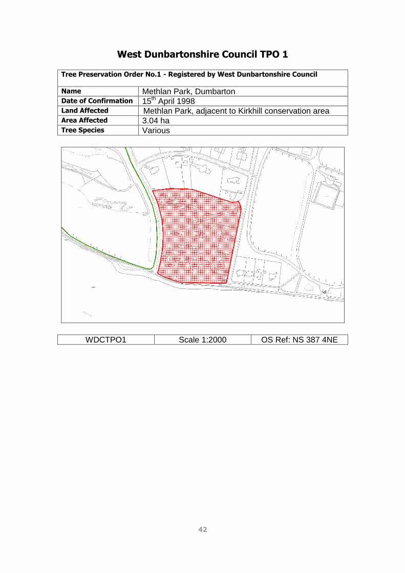
West Dunbartonshire Council TPO 1 Tree Preservation Order No.1 - Registered by West Dunbartonshire Council
Name Methlan Park, Dumbarton Date of Confirmation 15th April 1998 Land Affected Methlan Park, adjacent to Kirkhill conservation area Area Affected 3.04 ha Tree Species Various
WDCTPO1 Scale 1:2000 OS Ref: NS 387 4NE

43
West Dunbartonshire Council TPO 2 Tree Preservation Order No.2 - Registered by West Dunbartonshire Council
Name Dumbuck Bowling Club, Dumbarton Date of Confirmation 21st January 1998 Land Affected Oak trees to the south and west of Dumbuck Bowling
Club, Dumbarton Area Affected 2863.13 m² Tree Species Oak
WDCTPO2 Scale 1:1250 OS Ref: NS 417 4NW

44
West Dunbartonshire Council TPO 3 Tree Preservation Order No.3 - Registered by West Dunbartonshire Council
Name ‘Craigard’, Upper Bridge Street, Alexandria Date of Confirmation 22nd April 1998 Land Affected Mature trees on the northern and eastern boundaries of
Craigard, Upper Bridge Street, Alexandria Area Affected 2481.2 m² Tree Species Oak
WDCTPO3 Scale 1:1250 OS Ref: NS 387 9NE

45
West Dunbartonshire Council TPO 4 Tree Preservation Order No.4 - Registered by West Dunbartonshire Council
Name Levenbank Terrace Date of Confirmation 12th June 2002 Land Affected Seven individual trees along North Main Street to the
west of Levenbank Terrace, Jamestown Tree Species 4 no. Common Lime, 3 no. Sycamore
WDCTPO4 Scale 1:1500 OS Ref: NS 398 1SE

46
West Dunbartonshire Council TPO 5 Tree Preservation Order No.5 - Registered by West Dunbartonshire Council
Name Vale of Leven Hospital Date of Confirmation 12th June 2002 Land Affected Grounds within the Vale of Leven Hospital, Alexandria.
A number of mature trees Area Affected 3.52 ha Tree Species Larch, Spruce, Oak, Beech, Ash, Scots Pine, Lime,
Sycamore and Horse Chestnut
WDCTPO5 Scale 1:2500 OS Ref: NS 388 0NE

47
West Dunbartonshire Council TPO 6 Tree Preservation Order No.6 - Registered by West Dunbartonshire Council
Name Round Riding Road, Dumbarton Date of Execution 19th June 2002 Date of Confirmation 27th June 2002 Land Affected Trees at the north end of the grounds of Rose Cottage,
59 Round Riding Road, Dumbarton Area Affected 185.03 m² Tree Species Sycamore and Birch
WDCTPO6 Scale 1:500 OS Ref: NS 398 1SE

48
West Dunbartonshire Council TPO 7 Tree Preservation Order No.7 - Registered by West Dunbartonshire Council
Name Auchentoshan Woods, Clydebank Date of Execution 12th June 2002 Date of Confirmation 5th November 2002 Land Affected Substantial woodland area south of the A82 in
Clydebank, east of Auchentoshan Estate (separately covered by CDCTPO7)
Area Affected 5.71 ha² Tree Species Various native species
WDCTPO7 Scale 1:2500 OS Ref: NS 487 2NE

49
West Dunbartonshire Council TPO 8 Tree Preservation Order No.8 - Registered by West Dunbartonshire Council
Name Cables Drive, Dalmonach Date of Confirmation 29th August 2007 Land Affected Large sycamore on the boundary between 65 Main
Street Bonhill and 1 Oakfield Drive Bonhill, Alexandria Tree Species Sycamore
WDCTPO8 Scale 1:1000 OS Ref: NS 398 0SE

50
West Dunbartonshire Council TPO 9 Tree Preservation Order No.9 - Registered by West Dunbartonshire Council
Name Overtoun Avenue and Silverton Avenue, Dumbarton Date of Execution 24th January 2008 Date of Confirmation 9th May 2008 Land Affected 36 no. trees lining either side of Overtoun Avenue and
Silverton Avenue, positioned on the narrow grass verge between the footpath and the highway.
Tree Species Predominately mature prunus avium (Wild Cherry) and betula pendula (Silver Birch)
WDCTPO9 Scale 1:2500 OS Ref: NS 407 5SE

51
West Dunbartonshire Council TPO 10 Tree Preservation Order No.10 - Registered by West Dunbartonshire Council
Name Islay Kerr House and 12 Kirkton Road, Dumbarton Date of Confirmation 20th November 2003 Land Affected Grounds of Islay Kerr House and 12 Kirkton Road,
Dumbarton Area Affected 0.97 ha Tree Species Various
WDCTPO10 Scale 1:1250 NS 387 5SE

52
West Dunbartonshire Council TPO 11 Tree Preservation Order No.11 - Registered by West Dunbartonshire Council
Name Edinbarnet Wood Date of Execution 26th May 2010 Date of Confirmation 7th September 2010 Land Affected Edinbarnet Wood, Cochno Road, Clydebank Area Affected 6.48 ha Tree Species Various
WDCTPO11 Scale 1:5000 NS 507 4SE

53
West Dunbartonshire Council TPO 12 Tree Preservation Order No.12 - Registered by West Dunbartonshire Council
Name Rockbank Place, Hardgate Date of Execution 21st May 2010 Date of Confirmation 27th August 2010 Land Affected Land to the rear of Rockbank Place/Car showroom at
the Hardgate roundabout. Area Affected 0.25 ha Tree Species 14 no. Scots pine trees
WDCTPO12 Scale 1:1250 NS 507 2NW