trca - humber bay park - terrestrial biological inventory (march, 2014)
DESCRIPTION
In 2013 the Toronto Region Conservation Authority (TRCA) conducted a flora and fauna inventory of the Humber Bay Park, including both Humber Bay East and West, and the adjacent mainland lakeshore: Humber Bay Shores. In this report these three areas are considered as a single larger study area: Humber Bay Park, an area that has undergone extensive management in the past few years.The TRCA conducted field work within the study area to assess the results of the management activities regarding vegetation communities, flora and fauna species and to estimate the success of plantings and installed habitat features. The inventory provides background data for the City of Toronto’s park revitalization plans for the three sections of Humber Bay Park.TRANSCRIPT

Humber Bay Park
Terrestrial Biological Inventory and Assessment
March, 2014

Report prepared by: Paul Prior, Fauna Biologist
Gavin Miller, Flora Biologist
Alberta D’Souza, GIS Technologist
Reviewed by: Sue Hayes, Project Manager, Terrestrial Field
Inventories
Scott Jarvie, Manager, Watershed Monitoring and
Reporting Section
This report may be referenced as:
Toronto and Region Conservation Authority (TRCA). 2014.
Humber Bay Park Terrestrial Biological Inventory and Assessment.

H u m b e r B a y P a r k
March , 2014
1
Table of Contents
p a g e
1.0 Introduction .................................................................... .....................3
1.1 TRCA’s Terrestrial Natural Heritage Program ............................................................. 3
2.0 Study Area Description ...................................................................... 4
3.0 Inventory Methodology ...................................................................... 5
3.1 Landscape Analysis. ..................................................................................................... 5
3.2 Ranking and Scoring Communities and Species ....................................................... 6
3.3 Vegetation Community and Species .......................................................................... 7
4.0 Results and Discussion ...................................................................... 7
4.1 Regional Context ......................................................................................................... 8
4.2 Vegetation Community Findings for Humber Bay Park .............................................. 8
4.2.1 Vegetation Community Representation ........................................................................ 8
4.2.2 Vegetation Communities of Concern ............................................................................ 9
4.3 Flora Findings for Humber Bay Park ......................................................................... 11
4.3.1 Flora Species Representation ..................................................................................... 11
4.3.2 Flora Species of Concern ........................................................................................... 12
4.3.3 Plantings ...................................................................................................................... 13
4.3.4 Invasive Species .......................................................................................................... 15
4.4 Fauna Findings for Humber Bay Park ....................................................................... 16
4.4.1 Fauna Species Representation ................................................................................... 16
4.4.2 Fauna Species of Concern ......................................................................................... 17
5.0 Recommendations ............................................................................ 22
5.1 Site Highlights ........................................................................................................... 22
5.2 Site Recommendations ............................................................................................. 23
6.0 References ......................................................................................... 28

H u m b e r B a y P a r k
March , 2014
2
p a g e
L is t o f Tab les Table 1: Habitat patch quality, rank and species response ........................................................ 6 Table 2: Schedule of the TRCA biological surveys at Humber Bay Park ................................... 7 Table 3: Breakdown of fauna species of concern at Humber Bay Park ................................... 17
L is t o f F igures Figure 1: Humber Bay Butterfly Habitat: tallgrass prairie planting dating from 1998-2000 ....... 11 Figure 2: Balsam ragwort, established at the Humber Bay Butterfly Habitat ............................ 15 Figure 3: Grey catbird, well-represented at Humber Bay Park .................................................. 19
L is t o f Maps
Map 1: Humber Bay Park in the Context of Regional Natural Cover .......................................... 30
Map 2: Humber Bay Park (aerial view) ......................................................................................... 31
Map 3: TRCA Regional Natural System Habitat Patch Quality .................................................... 32
Map 4: TRCA Distribution of Fauna Regional Species of Concern ............................................. 33
Map 5: Habitat Patch Size Scores with Fauna Area Sensitivity ................................................... 34
Map 6: Scores for Matrix Influence and Flora Sensitivity to Development .................................. 35
Map 7: Scores for Matrix Influence and Fauna Sensitivity to Development ................................ 36
Map 8: Humber Bay Park Habitat Patch Quality .......................................................................... 37
Map 9: Vegetation Communities with their Associated Local Ranks .......................................... 38
Map 10: Location of Flora Species of Concern ........................................................................... 39
Map 11: Flora Habitat Dependence Scores ................................................................................. 40
Map 12: Location of Fauna Species of Concern ......................................................................... 41
List of Appendices Appendix 1: List of Vegetation Communities ............................................................................ 42
Appendix 2: List of Flora Species ............................................................................................. 44
Appendix 3: List of Fauna Species ........................................................................................... 54

H u m b e r B a y P a r k
March , 2014
3
1.0 Introduction
In 2013 the Toronto Region Conservation Authority (TRCA) conducted a flora and fauna
inventory of the Humber Bay Park, including both Humber Bay East and West, and the
adjacent mainland lakeshore: Humber Bay Shores. In this report these three areas are
considered as a single larger study area: Humber Bay Park, an area that has undergone
extensive management in the past few years. As shown in Maps 1 and 2, the study area is
located on the Lake Ontario shoreline at the mouth of Mimico Creek (please refer to section
2.0 for details).
The TRCA conducted field work within the study area to assess the results of the management
activities regarding vegetation communities, flora and fauna species and to estimate the
success of plantings and installed habitat features. The inventory provides background data
for the City of Toronto’s park revitalization plans for the three sections of Humber Bay Park.
The site features are to be understood within the larger regional context provided by the
Terrestrial Natural Heritage Program of the TRCA (see Section 1.1), keeping in mind the
question “How does Humber Bay Park fit within the regional and watershed natural system, and
how should its contribution to this system be protected and maximized?” The important
underlying message presented by this question is that the health of the natural system is
measured at the regional scale and specific sites must be considered together for their
benefits at all scales, from the site to the larger system.
1.1 TRCA’s Terrestrial Natural Heritage Program
Rapid urban expansion in the TRCA jurisdiction has led to continuous and incremental loss of
natural cover and species. In a landscape that probably supported 95% forest cover prior to
European settlement, current mapping shows that only 17% forest and wetland cover remains.
Agricultural and natural lands are increasingly being urbanized while species continue to
disappear from a landscape that is less able to support them. This represents a substantial
loss of ecological integrity and ecosystem function that will be exacerbated in the future
according to current urbanization trends. With the loss of natural cover, diminishing
proportions of various natural vegetation communities and reduced populations of native
species remain. Unforeseen stresses are then exerted on the remaining flora and fauna in the
natural heritage system. They become even rarer and may eventually be lost.
This trend lowers the ability of the land to support biodiversity and to maintain or enhance
human society (e.g. through increased pollution and decreased space for recreation). The
important issue is the cumulative loss of natural cover in the TRCA region that has
resulted from innumerable site-specific decisions.
In the late 1990s the TRCA initiated the Terrestrial Natural Heritage Program to address the
loss of terrestrial biodiversity within the jurisdiction’s nine watersheds. This work is based on

H u m b e r B a y P a r k
March , 2014
4
two landscape-level indicators: the quality distribution of natural cover and the quantity of
natural cover. These indicators summarize changes that occurred within the historical natural
system. The aim of the program is to create a conservation strategy that both protects
elements of the natural system (vegetation communities, flora and fauna species) before they
become rare and promotes greater ecological function of the natural system as a whole. This
preventive approach is needed because by the time a community or species has become
rare, irreversible damage has often already occurred. A healthy natural system capable of
supporting regional biodiversity in the long term is the goal of the Terrestrial Natural Heritage
Systems Strategy (TNHSS) by setting targets – both short and long-term (100 years) – for the
two landscape indicators in order to provide direction in planning at all scales (TRCA 2007a,
TRCA 2007b).
A target system that identifies a land base where natural cover should be restored is a key
component of the Strategy. Although the objectives of the Strategy are based on making
positive changes at all scales, the evaluation models were developed at the landscape scale
using a combination of digital land cover mapping and field-collected data. Field-collected
data also provides ground-level information in the application of the landscape models at the
site scale. The two indicators and the targets that have been set for them are explained in
Section 3.1. It is important to understand that habitat quality and distribution are
interdependent. For example, neither well-distributed poor-quality natural cover nor poorly-
distributed good-quality natural cover achieves the desired condition of sustainable
biodiversity and social benefits across the watershed.
2.0 Study Area Description
Humber Bay Park lies on the shore of Lake Ontario at the mouth of Mimico Creek (Map 1). The
site is within the Carolinian floristic region, which is composed of mainly deciduous forest.
Mid-twentieth century soil mapping shows the soils to be Chinguacousy clay loam next to the
immediate lakeshore and Berrien sandy loam to the north (Hoffman and Richards 1955).
However, the surficial geology and soils at this location have been almost entirely replaced by
anthropogenic fill deposited from the mid-twentieth century up to 2007 (in fact the site itself
was underwater before fill emplacement). The area used to be known as the Etobicoke Motel
Strip because for much of the 20th century, the waterfront was occupied by low-end motels.
Since 2000, these lands (now immediately to the north of the fill which comprises the park)
have been covered by new condominium development.
The peninsulas that comprise the East and West Parks along with the adjacent main shoreline
(Humber Bay Shores) are a result of the depositing of lakefill by the TRCA at the mouth of the
Mimico Creek (Map 2). The park was opened to the public in 1984 and since then there have
been several initiatives aimed at improving the habitat available on this artificially created
landform. The park provides additional recreational space and opportunities for the creation of
“natural” habitats. The Park is part of a semi-continuous corridor of natural cover and public

H u m b e r B a y P a r k
March , 2014
5
parkland along the Toronto waterfront, including the multi-use Waterfront Trail. The area has
high recreational use by hikers and dog-walkers. Yacht clubs cover much of the western
peninsula of Humber Bay Park.
3.0 Inventory Methodology
In 2013 the first full biological inventory of the Humber Bay Park study area was conducted.
The inventory covered vegetation communities and species (flora and fauna) according to the
TRCA methodology for field data collection (TRCA 2007d).
3.1 Landscape Analysis
The quality, distribution and quantity of natural cover in a region are important determinants of
the species distribution, vegetation community health and the provision of “ecosystem
services” (e.g. air and water quality, recreation, aesthetics) in that region.
Base Mapping
The first step in evaluating a natural system or an individual habitat patch is to interpret and
map land cover using aerial photographs. The basic unit for the evaluation at all scales is the
habitat patch in the region, which are then combined and evaluated as a system at any scale.
A habitat patch is a continuous piece of habitat, as determined from aerial photo interpretation.
The TRCA maps habitat according to four broad categories: forest, wetland, meadow, and
coastal (beach, dune, or bluff). At the regional level, the TRCA jurisdiction is made up of
thousands of habitat patches. This mapping of habitat patches in broad categories is
conducted through remote–sensing and is used in the evaluation of quality, distribution and
quantity of natural cover. It should not be confused with the more detailed mapping of
vegetation communities obtained through field surveys and that is used to ground-truth the
evaluation (see Section 3.3).
Quality Distribution of Natural Cover
The quality of each habitat patch is evaluated according to three criteria: size (the number of
ha occupied by the patch), shape (edge-to-area ratio), and matrix influence (measure of the
positive and negative impacts from surrounding land use) (TRCA 2007c). A total score for
each patch is obtained through a weighted average of the scores for the three criteria. This
total score is used as a measure of the ‘quality’ of a habitat patch and is translated into a local
rank (L-rank) ranging from L1 to L5 based on the range of possible total scores from three to
15 points. Of these L-ranks, L1 represents the highest quality habitat and L5 the poorest.
Species presence or absence correlates to habitat patch quality (size, shape and matrix
influence) (Kilgour, 2003). The quality target is based on attaining a quality of habitat patch
throughout the natural system that would support in the very long term a broad range of

H u m b e r B a y P a r k
March , 2014
6
biodiversity, more specifically a quality that would support the region’s fauna Species of
Conservation Concern (Table 1).
Table 1: Habitat patch quality, rank and species response
Size, Shape and Matrix
Influence Patch Rank
Fauna Species of Conservation
Concern
Excellent L1 Generally found
Good L2 Generally found
Fair L3 Generally found
Poor L4 Generally not found
Very Poor L5 Generally not found
In addition to the three criteria that make up the total habitat patch score, another important
measure to consider in assessing habitat patch quality is forest interior, i.e. the amount of
forest habitat that is greater than 100 meters from the edge of the forest patch, using 100
meter increments. A recognized distance for deep interior conditions occurs at 400 meters
from the patch edge. Such conditions are a habitat requirement for several sensitive fauna
species.
Quantity
The quantity target is the amount of natural cover which needs to exist in the landscape in
order to accommodate and achieve the quality distribution targets described above. The two
targets are therefore linked to each other: it will be impossible to achieve the required
distribution of natural heritage quality without the appropriate quantity of natural cover. The
proportion of the region that needs to be maintained as natural cover in order to achieve the
desired quality has been identified as 30%.
3.2 Ranking and Scoring Communities and Species
While the targets for the natural heritage system are derived from regional-scale information,
the ground-truthing surveys at the site level provide important information that can be used in
conjunction with the targets to plan decisions at the site level. A key component of the ground-
truthing surveys is the scoring and ranking of vegetation communities and flora and fauna
species to generate local “L” ranks (L1 to L5), which were first assigned in 1996-2000. These
are reviewed and updated regularly (TRCA 2010). They roughly correspond to the habitat
patch ranks. For example, a species ranked L4 may be expected in habitat patches with a
quality of L4 or better.
Vegetation community scores and ranks are based on two criteria: local occurrence and the
number of geophysical requirements or factors on which they depend. Flora species are
scored using four criteria: local occurrence, population trend, habitat dependence, and

H u m b e r B a y P a r k
March , 2014
7
sensitivity to impacts associated with development. Fauna species are scored based on seven
criteria: local occurrence, local population trend, continent-wide population trend, habitat
dependence, sensitivity to development, area-sensitivity, and patch isolation sensitivity. With
the use of this ranking system, communities or species of regional concern, ranked L1 to L3,
now replace the idea of rare communities or species. Rarity (local occurrence) is still
considered but is now one of many criteria that make up the L-ranks, making it possible to
recognize communities or species of regional concern before they have become rare.
In addition to the L1 to L3 ranked species, a large number of currently common or secure
species at the regional level are considered of concern in the urban context. These are the
species identified with an “L” rank of L4. Although L4 species are widespread and frequently
occur in relatively intact urban sites, they are vulnerable to long-term declines.
3.3 Vegetation Community and Species
Vegetation communities and flora and fauna species were surveyed concurrently. Botanical
field-work for the site was conducted in the summer of 2013 (Table 2). Vegetation community
designations were based on the Ecological Land Classification (ELC) and determined to the
level of vegetation type (Lee et al. 1998). Community boundaries were outlined onto printouts
of 2007 digital ortho-rectified photographs (ortho-photos) to a scale of 1:2000 and then
digitized in ArcView. Flora regional and urban species of concern (species ranked L1 to L4)
were mapped as point data with approximate number of individuals seen.
Fauna data were collected by the TRCA in May and June of 2013 (Table 2). These surveys
were concerned primarily with the mapping of breeding bird species of regional concern.
Songbirds are surveyed in late May to July in order to obtain breeding bird data and to
exclude migrants. The methodology for identifying confirmed and possible breeding birds
follows Cadman et al. (2007). Fauna species of regional and urban concern (species ranked
L1 to L4) were mapped as point data with each point representing a possible breeding pair.
Table 2: Schedule of the TRCA biological surveys at Humber Bay Park study area
Survey Item Survey Dates Survey Effort (hours)
Vegetation Communities
and Flora Species
7th , 12th, 20th and 25th June; 31st Jul; 17th
and 24th Sep 2013 40 hours
Breeding Songbirds 24th and 29th May and 20th June, 2013. 10 hours
4.0 Results and Discussion
Information pertaining to the Humber Bay Park study area was collected through both remote-
sensing and ground-truthing surveys. This information contains three levels of detail: habitat
patch, vegetation community, and species (flora and fauna). This section provides the
information collected and its analysis in the context of the TNHS Strategy.

H u m b e r B a y P a r k
March , 2014
8
4.1 Regional Context
Based on 2007/08 orthophotography, 25% of the land area in the TRCA jurisdiction consists of
natural cover but this figure includes meadow and old field. Although historically, the region
would have consisted of up to 95% forest cover, today (i.e. 2007/08) only about 17% is
covered by forest and wetland. Of the non-natural cover (i.e. the remaining 75%), 48% is urban
and 27% is rural / agricultural.
The regional level analysis of habitat patches shows that the present average patch quality
across the TRCA jurisdiction is “fair” (L3); forest and wetland cover is contained largely in the
northern half of the TRCA jurisdiction, especially on the Oak Ridges Moraine; and the quantity
is 16% of the surface area of the jurisdiction (Map 3). Thus the existing natural system stands
below the quantity target that has been set for the region (30%) and also has an unbalanced
distribution. The distribution of fauna species of concern is also largely restricted to the
northern part of the jurisdiction; fauna species of regional concern are generally absent from
the urban matrix (Map 4). The regional picture, being the result of a long history of land use
changes, confirms that all site-based decisions contribute to the condition of a region.
According to the ground-truthed vegetation surveys, the study area includes a total of 31.8 ha
of natural cover (Appendix 1). Of this natural cover, 2.3 ha are identified as meadow, 10.8 ha
as successional habitat, 4.4 ha as plantation, 2.7 ha as wetland, 3.5 as vegetated aquatic, and
8.1 ha as “dynamic” (artificial beach or prairie) habitat. The proximity of Lake Ontario
complicates attempts to provide accurate patch quality assessment, especially with such
small patches. This complication arises because Lake Ontario is assigned a positive matrix
influence score (since it is a natural feature) and this incidentally raises the overall patch
quality score of any neighbouring habitat patches. Map 5 shows that the habitat patches at the
Humber Bay Complex score “very poor” (L5) for patch size, but this score is tempered by the
artificially high “good” (L2) score that many of the habitat patches attain (Maps 6 and 7) due to
the proximity of Lake Ontario resulting in an over all “poor” patch quality score (Map 8) when
in fact a more appropriate score would be “very poor” (L5). However, it is anticipated that part
of the sheltered embayment will become wetland over time, and more vegetation may arise
spontaneously amid the armour stone and through planting. Any increase in natural cover
would improve the site and also increase positive matrix influence on nearby areas such as
Mimico Waterfront Linear Park (TRCA 2014).
4.2 Vegetation Community Findings for Humber Bay Park
4.2.1 Vegetation Community Representation
In 2013, 34 vegetation community types were described for Humber Bay Park (Appendix 1).
There are 7 “forest” communities (actually all young plantation); 10 successional communities;

H u m b e r B a y P a r k
March , 2014
9
7 dynamic communities, 2 meadow communities, 5 wetland communities, and 3 aquatic
communities. These communities are all anthropogenic in origin and disturbed in character;
the oldest would date from no earlier than the late 1970s.
Plantation communities provide 4.4 ha of natural cover, though because of their young age
(maximum about 30 years) and small fragmentary character, should be included functionally
with the successional communities, which account for another 10.8 ha. These communities
together thus make up about half the site. A blend of woody plants with fragmentary to partial
canopy closure is characteristic of these communities, and it is not always apparent how
much of the woody material is planted or naturally-regenerating. Prominent vegetation types
include Native Deciduous Savannah (CUS1-A1) and Restoration Deciduous Plantation (CUP1-
A). The oldest, most closed-canopy communities are Ash-Conifer Mixed Plantation (CUP2-G)
and Austrian Pine Coniferous Plantation (CUP3-b). The planted material found in these
communities is relatively young and vulnerable to competition from other more aggressive
exotic species currently establishing at the site. The lower and ground layers are generally
dominated by exotic species such as garlic mustard (Alliaria petiolata), hedge parsley (Torilis
japonica), and shrub honeysuckles (Lonicera spp). Small parts of the site still have few
enough trees to be classed as meadow (2.3 ha).
Dynamic communities at natural sites generally are the result of energetic processes (fire,
wave and wind erosion) which maintain the community in an open or semi-open condition. At
Humber Bay Park however, the processes are artificial (grading and filling), resulting in largely-
stabilized shoreline communities on armour stone rock or cobble, along with a couple of
prairie plantings and gravelly mud-flats sometimes visible along the estuary of Mimico Creek
(these treated as Open Riparian Sand / Gravel Bar).
Wetlands occupy 2.7 ha (9% of the site) and are evenly split between Willow Mineral Thicket
Swamp (SWT2-2) forming a fringe around many of the lagoon areas; and marshes, largely
Hybrid Cattail Mineral Shallow Marsh (MAS2-1b) and Common Reed Mineral Shallow Marsh
(MAS2-a).
4.2.2 Vegetation Communities of Concern
The vegetation communities that occur in the TRCA jurisdiction are scored and given a local
rank from L1 to L5 based on the two criteria mentioned in Section 3.2. Community boundaries
and ranks are shown on Map 9.
Humber Bay Park has 12 communities of conservation concern (rank L1-L4). They occupy 8.7
ha (28%) of the site. Because of the relatively new character of the site, the ranks may not
always perfectly reflect community sensitivity. For example, the Mineral Open Beach (BBO1)
(rank L3) and Mineral Treed Beach (BBT1-A) (rank L2) are considered “natural” because they
formed on cobble and are subject to wave action. However, they are protected by armour
stone areas and do not have much native vegetation at present. The high rank reflects their
potential to support coastal vegetation.

H u m b e r B a y P a r k
March , 2014
10
On the other hand, there are a couple of patches of Fresh-Moist Cottonwood Tall Treed
Woodland (CUW1-A4) (rank L3) which at this time do have a complex structure and support a
suite of native coastal plants.
In addition, three of the wetlands have developed into natural communities of conservation
concern: Willow Mineral Thicket Swamp (SWT2-2) (rank L4) forming densely along lagoon
shorelines; Bur-reed Mineral Shallow Marsh (MAS2-7) (rank L3), and Forb Mineral Shallow
Marsh (MAS2-9). The latter is a fairly sparse community on exposed mud, almost better
classed as a mudflat but still of conservation interest for its periodic growth of annual plants
and provision of bird habitat.
A small amount of the lagoon area has enough vegetation to be considered a Pondweed
Submerged Shallow Aquatic Community (SAS1-1) (rank L4). There is also a land-locked but
artificially-fed pond and channel system on the east peninsula of Humber Bay Park that is a
Water Milfoil Submerged Shallow Aquatic Community (SAS1-4) (rank L4). The aquatic
macrophyte growth here is dense; unfortunately most of it is the invasive Eurasian Water-
milfoil (Myriophyllum spicatum). This community is more contained and isolated from lake
influences than the lagoons.
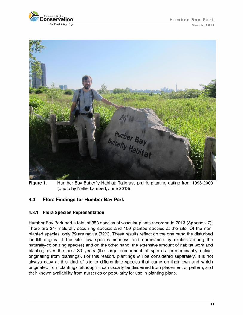
The community of the greatest conservation interest at Humber Bay Park is actually the prairie
planting associated with the Humber Bay Butterfly Habitat project, which dates from 1998-
2000 (Figure 1). This vegetation type is classified as Fresh-Moist Tallgrass Prairie Planting
(TPO2-A) and is ranked L5 because it is planted. However, the project was carefully prepared
and planned, using mostly locally-sourced and documented material, and includes many
species of conservation concern (see Section 4.3.3). Invasive species are moving into the
prairie but many of the natives are abundant.
H u m b e r B a y P a r k
March , 2014
11
Figure 1. Humber Bay Butterfly Habitat: Tallgrass prairie planting dating from 1998-2000
(photo by Nettie Lambert, June 2013)
4.3 Flora Findings for Humber Bay Park
4.3.1 Flora Species Representation
Humber Bay Park had a total of 353 species of vascular plants recorded in 2013 (Appendix 2).
There are 244 naturally-occurring species and 109 planted species at the site. Of the non-
planted species, only 79 are native (32%). These results reflect on the one hand the disturbed
landfill origins of the site (low species richness and dominance by exotics among the
naturally-colonizing species) and on the other hand, the extensive amount of habitat work and
planting over the past 30 years (the large component of species, predominantly native,
originating from plantings). For this reason, plantings will be considered separately. It is not
always easy at this kind of site to differentiate species that came on their own and which
originated from plantings, although it can usually be discerned from placement or pattern, and
their known availability from nurseries or popularity for use in planting plans.

H u m b e r B a y P a r k
March , 2014
12
4.3.2 Flora Species of Concern
Twenty species of regional (L1-L3) or urban concern (L4) were recorded at Humber Bay Park in 2013. Appendix 2 lists plant species by ranks and locations are shown on Map 10. The ranks are based on sensitivity to human disturbance associated with development; and habitat dependence, as well as on rarity (TRCA 2010). Rarity is defined as being found in six or fewer of the forty-four 10x10 km UTM grid squares that cover the TRCA jurisdiction. In most cases, the species are not currently rare but are at risk of long-term decline due to the other criteria. There are 5 vascular plant species of regional conservation concern: water star-grass (Heteranthera dubia), foxtail wood sedge and troublesome sedge (Carex alopecoidea and C. molesta), hard-stemmed bulrush (Schoenoplectus acutus), and wood sage (Teucrium
canadense) (with a rank of L3). Three of these are sedges and all are readily dispersed, often by water. An additional 15 species have a rank of L4. Only one species of concern recorded at Humber Bay Park is actually rare (water star-grass); the other two have a low number of records because they have only recently been tracked: heal-all (Prunella vulgaris ssp. lanceolata) and pink hedge bindweed (Calystegia sepium ssp. americana).
Eighteen of the 20 species of regional or urban concern are habitat specialists to some extent
(Map 11). Half of these, such as peach-leaved willow (Salix amygdaloides), boneset
(Eupatorium perfoliatum), and hard-stemmed bulrush are wetland species associated with the
shoreline and inlets. The variegated bulrush (Equisetum variegatum) actually tends to be even
more restricted, to calcareous wetlands (including coastal thicket swamps) and so reflects the
site’s proximity to Lake Ontario. There are also 3 aquatic species of concern: the water star-
grass, which tends to be specific to Lake Ontario sites; greater duckweed (Spirodela
polyrhiza), and a water-weed which was likely Canada waterweed (Elodea canadensis) but
was not accessible for absolute verification. Nuttall’s waterweed (E. nutallii) also can occur
along the lakeshore. There were 5 species of concern typical of successional (or terrestrial
shoreline) habitats, such as Emerson’s hawthorn (Crataegus submollis), pink hedge bindweed
and paper birch (Betula papyrifera) which had natural as well as planted occurrences. One
open-land species was typical of prairie habitats though slightly generalist: sky-blue aster
(Symphyotrichum oolentangiense).
Vulnerability to impacts caused by nearby development or human land use generally is
another factor affecting species of concern. In the case of Humber Bay Park, there are 17 L1
to L4 flora species that have a somewhat elevated score (Map 5). The main risk is from being
overrun by invasive exotics, since the flora are fairly disturbance-tolerant in other ways. This is
particularly true of the wetland species that are outcompeted by common reed (Phragmites
australis ssp. australis) and hybrid cattail (Typha x glauca). Foxtail wood sedge and
troublesome sedge grow well in disturbed landscapes but do not compete well in the long
term with woody invasive species such as buckthorn (Rhamnus cathartica) or herbaceous
invasives such as dog-strangling vine (Cynanchum rossicum) or reed canary grass (Phalaris
arundinacea). To some extent, the wetland species require fluctuating lake levels to maintain

H u m b e r B a y P a r k
March , 2014
13
suitable habitat. Wood sage grows well in areas that are occasionally below the high-water
mark, while hard-stemmed bulrush grows in more regularly-inundated areas.
Nutrient loading and sedimentation from storm water runoff, the outflow of Mimico Creek, and
Canada geese all contribute to increased growth of invasive species and reduced light
penetration in the water; both of which inhibit native wetland plants. Trampling at this highly-
used public park is intense, but most of the species present are not particularly sensitive.
4.3.3 Plantings
Numerous habitat creation and planting projects have taken place at Humber Bay Park since
the park was established. These range from clusters of trees and shrubs in landscape
plantings in the 1980s to expansions of the tree and shrub cover continuing to this day. The
most extensive work involved wetland habitat creation in the 1990s and the Humber Bay
Butterfly Habitat installation done around 1998-2000. Sixty-eight of the 109 (62%) planted
species seen in 2013 were native; this reflects the commitment of the recent landscape design
to using native species. Planted species ranked L1 to L4 are shown on Map 10.
Early landscape plantings were mostly of trees and shrubs, with less attention given to native
species. For example, the exotic (but not invasive) Austrian pine (Pinus nigra) is one of the
dominant species in the older plantings, chosen because of its adaptability to disturbed fill
soils and urban conditions. Some common native species such as red ash (Fraxinus
pennsylvanica) and staghorn sumac (Rhus typhina) are included; the ash were being treated
to prevent emerald ash borer in 2013. The more recent woody plantings, some as recent as
2013, had a slightly wider range of native species, but were still mostly the kind of common,
readily-available stock that is adaptable to the fill soils. The recent plantings include a number
of trees and shrubs that are not native to Toronto but are found in other parts of southern
Ontario, such as swamp white oak (Quercus bicolor) and Kentucky coffee-tree (Gymnocladus
dioicus). Tree and shrub plantings at Humber Bay have generally survived well, but with some
invasive species moving into the lower and ground layers.
Wetland plantings, largely in the 1990s, focused on the lagoons and shorelines of both
Humber Bay East and West. These plantings have had to contend with disruption by carp
(Cyprinus carpio) and Canada geese (Branta canadensis), as well as the omnipresent and
extremely aggressive common reed and hybrid cattail. To some extent, hybrid cattail was
actually planted since it provides habitat and was likely to have high success. Certain wetland
plants have established successfully and extensively, including greater bur-reed (Sparganium
eurycarpum), river bulrush (Bolboschoenus fluviatilis), soft-stemmed bulrush (Schoenoplectus
tabernaemontani), and water smartweed (Persicaria amphibia var. stipulacea). Common
arrowhead (Sagittaria latifolia) is locally abundant. These have generally either been able to
hold their own against the carp, geese, common reed and hybrid cattail, or adapt to slightly
deeper water levels. Other wetland plants are established, but only sporadically and in small
populations, such as blue flag (Iris versicolor and I. virginica), Baltic rush (Juncus arcticus ssp.
balticus), and swamp milkweed (Asclepias incarnata). And some, such as the bullhead lily

H u m b e r B a y P a r k
March , 2014
14
(Nuphar variegatum) transplanted from Heart Lake in 1993 (MTRCA 1994), could not be found
in 2013.
The most diverse and experimental planting at Humber Bay Park is the Humber Bay Butterfly
Habitat, which focused on prairie species with just a few shrubs and trees. This project
extends from the western part of Humber Bay Shores to the base of Humber Bay East. The
planting areas were first overlaid with a light, sandy topsoil to counteract the heavy underlying
fill, and species were chosen for their value to butterflies. In 2013, a large number of species
were still on site and thriving, including New Jersey tea (Ceanothus americanus), oxeye
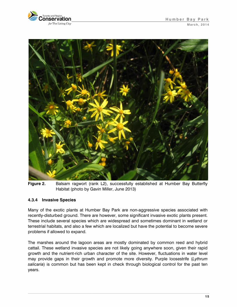
(Heliopsis helianthoides), foxglove beard-tongue (Penstemon digitalis), balsam ragwort
(Packera paupercula) (Figure 2), smooth aster (Symphyotrichum laeve), Indian grass
(Sorghastrum nutans), big bluestem (Andropogon gerardii), and short-fruited sedge (Carex
brevior). Moist prairie species included Canada bluejoint (Calamagrostis canadensis) prairie
cord-grass (Spartina pectinata), and spike blazing-star (Liatris spicata). As with the woody
species, some native to southern Ontario but not specifically Toronto were included, for
example Great Lakes St. John’s-wort (Hypericum kalmianum) and grey-headed coneflower
(Ratibida pinnata). Although many native plants are well-established, there is still a
considerable matrix of exotic herbs and cool-season grasses so the site is due to receive
some maintenance.
Given the intensely urban character of the park, strict adherence to locally-native species is
not as important as it would be in restoring a relict natural habitat such as Toronto Island.
H u m b e r B a y P a r k
March , 2014
15
Figure 2. Balsam ragwort (rank L2), successfully established at Humber Bay Butterfly
Habitat (photo by Gavin Miller, June 2013)
4.3.4 Invasive Species
Many of the exotic plants at Humber Bay Park are non-aggressive species associated with
recently-disturbed ground. There are however, some significant invasive exotic plants present.
These include several species which are widespread and sometimes dominant in wetland or
terrestrial habitats, and also a few which are localized but have the potential to become severe
problems if allowed to expand.
The marshes around the lagoon areas are mostly dominated by common reed and hybrid
cattail. These wetland invasive species are not likely going anywhere soon, given their rapid
growth and the nutrient-rich urban character of the site. However, fluctuations in water level
may provide gaps in their growth and promote more diversity. Purple loosestrife (Lythrum
salicaria) is common but has been kept in check through biological control for the past ten
years.

H u m b e r B a y P a r k
March , 2014
16
The landlocked pond system in on the east peninsula is dominated by the invasive aquatic
plant Eurasian water-milfoil, although this is a more controllable environment than the lagoons
directly open to the lake.
Dog-strangling vine (Cynanchum rossicum) is of moderate abundance in the terrestrial areas.
It is likely to become dominant as a matter of course, and poses a serious medium- and long-
term threat to the integrity of the Humber Bay Butterfly Habitat as it will certainly continue to
seed in.
Woody exotics such as Siberian elm (Ulmus pumila), European alder (Alnus glutinosa),
Russian-olive (Elaeagnus angustifolia), buckthorn (Rhamnus cathartica), Norway and Manitoba
maples (Acer platanoides and A. negundo) are likely to seed in and take over any terrestrial
plantings and successional areas. Where tree growth has resulted in some shade, for example
in the older plantings from the 1980s and 1990s, the understorey is largely shrub honeysuckle
and the ground layer occupied by hedge parsley and garlic mustard. All of these are prolific
seed-producers and the garlic mustard is known to have a long-lived seed bank.
One invasive plant that is still currently localized is oriental bittersweet (Celastrus orbiculatus),
growing along a fenceline on the western peninsula where it was planted.
Emerald ash borer (Agrilus planipennis) is now spreading through the Toronto area. Most
likely it will eventually kill almost all native ash trees (Fraxinus spp.) in the jurisdiction unless
they are treated with TreeAzin®, a formulation derived from the neem tree (Azadiracta indica)
that kills larvae that attempt to consume the cambium. Humber Bay Park has many ash,
especially red ash (F. pennsylvanica) in plantings. However, in 2013, many of the trees were
being treated.
4.4 Fauna Findings for Humber Bay Park
4.4.1 Fauna Species Representation
The TRCA fauna surveys at the site in 2013 documented a total of 37 bird species, 6
mammals, and 1 frog species for a total of 44 possible breeding fauna species. Note that in
2013 a small colony (20 nests) of cliff swallows (Petrochelidon pyrrhonota) was reported from
the bridge just beyond the northern limit of the study area; this species has been included in
the overall total. A handful of incidental records from the past decade add just two extra
species to the list: savannah sparrow (Passerculus sandwichensis) and white-tailed deer
(Odocoileus virginianus), were both observed in 2006. Therefore, given the 10 year limit on
inclusion of sightings into a current species list for any site, the Humber Bay Park species list
totals 46 species. Refer to Appendix 3 for a list of the breeding fauna species at the Humber
Bay Park study area and their corresponding L-ranks.

H u m b e r B a y P a r k
March , 2014
17
4.4.2 Fauna Species of Concern
Fauna species, like vegetation communities and flora species, are considered of regional
concern if they rank L1 to L3 based on their scores for the seven criteria mentioned in Section
3.2. It is important to also document the status of L4 species, i.e. those species that are of
concern within the urban portions of the region. As with flora, this is a proactive, preventive
approach, identifying where conservation efforts need to be made before a species becomes
rare. Map 11 shows locations of fauna from both categories.
Fauna surveys at the Humber Bay Park study area reported two L3 fauna species: hooded
merganser (Lophodytes cucculatus) and red-necked grebe (Podiceps grisegena). Both of
these sensitive nesting species were located in the enclosed lagoon on the east side of the
entrance to the East Park. The merganser was observed with two fledged young and may
have moved into the lagoon from potential nesting locations further up Mimico Creek (or the
nearby Humber River); the grebes on the other hand were observed attending a nest in the
lagoon.
There was a total of 14 L4 bird species reported in the past decade; in addition there were 5
mammal species and one frog species. Therefore (with the two L3 bird species) the overall
total for species of regional and urban concern (L1 – L4) at the study area is 22 species (Table
5). Note that one of these species, the barn swallow, is listed as Threatened at both the
Provincial and Federal levels, affording this species special protection. At the Humber Bay
Park study area, barn swallows were recorded nesting on buildings and bridges at three
locations throughout the area; the species also nests regularly at the neighbouring Mimico
Waterfront Linear Park, resulting in fairly large congregations of foraging swallows once the
young have fledged in mid to late summer (TRCA 2014).
Table 3: Breakdown of Species of Concern at Humber Bay Park study area
Fauna #
species
# L1–L3: Species of
Regional Concern
# L4: Species of
Urban Concern
Total # L1-L4: Species of
Regional or Urban
Concern
birds 38 2 14 16
herps 1 0 1 1
mammals 7 0 5 5
TOTALS 46 2 20 22
Local occurrence is one of seven scoring criteria for fauna species and is based on TRCA
data and information from the Natural Heritage Information Centre (NHIC) of the OMNR (NHIC
2008). Using local occurrence as a measure of regional rarity, any species that is reported as
a probable or confirmed breeder in fewer than 10 of the forty-four 10x10 km grid squares in
the TRCA jurisdiction is considered regionally rare (i.e. scores 3 to 5 points for this criterion)
(TRCA 2010). There were 3 regionally rare fauna species reported for the site: red-necked
grebe is a fairly recent arrival as a nesting species along this western section of the Toronto

H u m b e r B a y P a r k
March , 2014
18
waterfront, readily taking to artificial nest platforms when provided; gadwall (Anas strepera)
nests sporadically along the entire length of the lakeshore; and purple martin (Progne subis) is
reported as nesting in just 3 of the 44 regional grid squares, again associated with the
lakeshore. As is the case with flora, most regionally rare fauna species have other associated
factors that explain their vulnerability and need to be taken into account in conservation
strategies.
Sensitivity to development is another criterion used to determine the L-rank of fauna species.
A large number of impacts that result from local land use, both urban and agricultural, can
affect the local fauna. These impacts – considered separately from the issue of actual habitat
loss – can be divided into two distinct categories. The first category involves changes that
arise from local urbanization that directly affect the breeding habitat of the species in question.
These changes alter the composition and structure of the vegetation communities; for
example, the clearing and manicuring of the habitat (e.g. by removal of dead wood and
clearance of shrub understorey). The second category of impacts involves changes that
directly affect individuals of the species in question. Examples include increased predation
from an increase in the local population of predator species that thrive alongside human
developments (e.g. blue jays, Cyanocitta cristata; American crows, Corvus brachyrhynchos;
squirrels, Sciuridae; raccoons, Procyon lotor; and house cats, Felis catus); parasitism (from
facilitating the access of brown-headed cowbirds, Molothrus ater, a species which prefers
more open, edge-type habitat); competition (for nest-cavities with bird species such as house
sparrows, Passer domesticus; and European starlings, Sturnus vulgaris); flushing (causing
disturbance and abandonment of nest) and, sensitivity to pesticides.
Fauna species are considered to have a high sensitivity to development if they score three or
more points (out of a possible five) for this criterion. Twelve fauna species of regional or urban
concern, scoring as sensitive to development, were reported from the study area (Map 6).
Only one of these species, savannah sparrow, habitually nests on the ground and as such is
highly susceptible to ground-borne disturbance, e.g. off-leash dog-walking. The sole
savannah sparrow breeding record at the study area is from 2006, in the vicinity of the tip of
the West peninsula; an individual was observed in the same area in 2013, but too early in the
season to rule out the possibility of the individual being an actively migrating bird.
Interestingly, neither of these records is from one of the patches of natural cover identified as
meadow – savannah sparrows’ typical nesting habitat. It is highly likely that hiker and dog
disturbance in the highly fragmented meadow habitat throughout the study area is too intense
to allow such ground-nesting species to attempt nesting on a regular basis.
Of the remaining sensitive bird species at the study area, 2 are particularly well-represented
with 9 pairs of grey catbirds (Dumetella carolinensis) (Figure 3) and 11 pairs of willow
flycatchers (Empidonax traillii). These numbers are especially impressive when one considers
the actual amount of available habitat for these species at Humber Bay Park, and even more
so when compared to other lakeshore situations. Both species nest at medium heights in
sparse shrub cover (although grey catbird is more generalist, also nesting in forest edge
situations) where ground-borne disturbance is somewhat less of an issue.

H u m b e r B a y P a r k
March , 2014
19
It is important to understand that negative matrix influences are not solely associated with the
proximity of urban and suburban developments. Extensive public use of a natural habitat can
have substantial negative impact through the cumulative effects of hiking, dog-walking and
biking on the site. Such impacts are especially important for breeding fauna since repeated
disturbances have severe implications for nest attendance and the feeding of vulnerable
young; nest productivity in heavily used areas is reduced for all but the most resilient of
species (the latter including non-natives such as house sparrow and European starling). The
negative impacts are not quite as significant for migrant species particularly in situations
where individuals have the opportunity to move on to less disturbed areas. However, in the
urban landscape such opportunities are considerably restricted and in recent years the
importance of stop-over habitats in the life-cycles of migrant birds has become recognised as
a significant issue. It is as stop-over habitat that the vegetation communities at Humber Bay
Park become even more important for fauna, providing both foraging and shelter opportunities
for migrants passing through the urban landscape.
Figure 3. Grey catbird, (rank L4), was particularly well-represented at Humber Bay (Photo
by Paul Prior).
Area sensitivity is a scoring criterion that can be closely related to the issue of a species’
need for isolation. Fauna species are scored for area sensitivity based on their requirement for

H u m b e r B a y P a r k
March , 2014
20
a certain minimum size of preferred habitat. Species that require large tracts of habitat (>100
ha in total) score the maximum five points, while species that show no minimum habitat
requirement, or require <1 ha in total, score one point. Species scoring three points or more
(require 5+ ha in total) are deemed area sensitive species. There were a total of five area
sensitive species documented at the site, although the two L3 area sensitive species (hooded
merganser and red-necked grebe) should perhaps not really be considered since their local
foraging range would include the lower reaches of Mimico Creek or the Humber River, and the
near-shore waters of Lake Ontario, i.e. the terrestrial habitat patch size really has little impact
on these two species at this site.
The same could be said of two of the remaining three area-sensitive species. Mink (Mustella
vison) forages in a variety of riparian habitats and such habitats need to be relatively extensive
(at least 10 km in length) to provide enough opportunities for denning. The shoreline habitat
available at Humber Bay Park falls below the scoring threshold for this species but individuals
observed at the study area also have unrestricted access to considerably more shoreline
habitat both to the east and west of the site, and also inland along the lower Mimico Creek.
Similarly, although white-tailed deer require larger areas than are available at the study area,
the species readily moves across the urban landscape in search of appropriate foraging and
birthing situations.
The remaining species is great-crested flycatcher (Myiarchus crinitus), typically a forest-
associated cavity-nesting bird. Although this individual was reported well past the migrant-
threshold date used by the TRCA to indicate likelihood of breeding activity, it is probable that
this bird was actually a very late migrant. Such belated migrants sometimes summer at coastal
stop-over locations and the same is likely true of the red-eyed vireo (Vireo olivaceus) – another
forest-associated species - from the same area of the park on the same date.
Patch isolation sensitivity in fauna measures the overall response of fauna species to
fragmentation and isolation of habitat patches. One of the two main aspects of this scoring
criterion is the physical ability or the predisposition of a species to move about within the
landscape and is related to the connectivity of habitat within a landscape. The second main
aspect is the potential impact that roads have on fauna species that are known to be mobile.
Thus most bird species score fairly low for this criterion (although they prefer to forage and
move along connecting corridors) whereas many herpetofauna score very high (since their life
cycle requires them to move between different habitat types which may increase likelihood of
road-kill). One example of how this criterion affects species populations is the need for adult
birds to forage for food during the nestling and fledgling stage of the breeding season. By
maintaining and improving the connectivity of natural cover within the landscape (e.g. by
reforestation of intervening lands) we are able to positively influence the populations of such
species, improving their foraging and dispersal potential.
The issue of patch isolation sensitivity at the current site has little real impact on the breeding
fauna at Humber Bay Park; all four species which score high for this criterion are largely
aquatic and therefore have easy access to the near-shore waters of Lake Ontario and to the

H u m b e r B a y P a r k
March , 2014
21
lower reaches of both Mimico Creek and the Humber River. Certainly, for the three semi-
aquatic mammals, beaver (Castor canadensis), muskrat (Ondatra zibethicus) and mink, such
shoreline habitats allow for sufficient movement along the Lake Ontario shoreline, although all
three species are somewhat susceptible to road-kill. The fourth species is green frog
(Lithobates clamitans) which was reported from the ponds on Humber Bay Park East. There is
likely relatively easy interchange between populations at the Humber Bay site, Mimico Creek
and the lower Humber River, and therefore the urban landscape to the north of the park
probably has little impact on the lakeshore populations. There might perhaps be an issue
within the park where frogs have to cross heavily used paved surfaces, resulting in a level of
road-kill and mortality that restricts the growth of a healthy frog population. It is likely that other
non-avian species (specifically snakes) are also impacted by the extent and use of paved
surfaces within the park, but there were no snakes reported during the current fauna surveys,
and no incidental records in the past ten years.
Patch isolation at Humber Bay Park is potentially more significant regarding migrant
songbirds. If foraging and sheltering migrants are repeatedly disturbed then they will need to
re-locate to less-disturbed habitats – maintenance and replenishing of energy levels is
absolutely crucial for migrating individuals. If there is no viable connection between habitat
patches then considerable stress is placed on birds as they struggle to find opportunities to
move to other areas on their migration path. In this way, the establishment of a series of
natural refuges along the lakeshore and throughout the city’s ravine system becomes of
considerable importance.
Fauna species that score greater than three points under the habitat dependence criterion
are considered habitat specialists. These species exhibit a combination of very specific habitat
requirements that range from their microhabitat (e.g. decaying logs, aquatic vegetation) and
requirements for particular moisture conditions, vegetation structure or spatial landscape
structures, to preferences for certain community series and macro-habitat types. Red-necked
grebe and northern rough-winged swallow are the only fauna species breeding at Humber
Bay Park which are considered habitat specialists, both species requiring very specific nesting
opportunities. For the red-necked grebe, in the absence of any extensive floating aquatic
vegetation, artificial nest-rafts need to be provided. For the swallow, there is a prerequisite of
cavities, often over water, for nesting, either natural or man-made.
Migrating birds tend to be somewhat generalist in their habitat selection, even those species
that are otherwise extreme habitat specialists in their breeding locations. The most important
habitat considerations for migrant songbirds are the availability of food and shelter.
Richness is essentially the presence or absence of species at a site. Beyond mere presence of
single species is the idea that a natural system can be considered as a healthy functioning
system if there is an association of several species thriving within that system. Each habitat
type supports particular species associations. As the quality of the habitat patch improves so
will the representation of flora and fauna species within that habitat. In this way representation
biodiversity is an excellent measure of the health of a natural system. The presence of a very

H u m b e r B a y P a r k
March , 2014
22
low number of habitat dependent species indicates that the habitat in the study area is
functioning at a rather low level. To some extent, this is to be expected given the urban
landscape in which the site is embedded, and the artificial nature of the entire peninsula and
shoreline. However, for two of the L4 species, grey catbird and willow flycatcher, their
numbers indicate that there is at least potential for the area to support a thriving population of
these somewhat sensitive open-habitat and shrub-habitat dependent species.
5.0 Recommendations
The recommendations for the Humber Bay Park study area are given in relation to the regional
targets for natural heritage in the TRCA jurisdiction. Every site, no matter how small, makes its
own contribution to the natural system and will require its own individualized plan of action.
Following is a short summary of the site highlights, followed by specific recommendations.
5.1 Site Highlights
1. The site is part of the Lake Ontario shoreline corridor, enhancing the natural connection between the mouths of the Mimico Creek and the Humber River.
2. A total of 244 naturally-occurring and 109 planted flora species were observed, showing relatively low species richness augmented by intensive habitat restoration.
3. Five flora species of regional concern (L1-L3), including water star-grass and
troublesome sedge, and 15 species of urban zone concern (L4) were found as naturally-colonized populations.
4. Numerous plantings date from the 1980s to the present, including tree groves,
wetlands, and prairie; with fair to good success rates. Tree plantings have largely had good survival, but are being compromised by invasive species, especially in the shrub and ground layers.
5. The Humber Bay Butterfly Habitat planting, which includes a diversity of sensitive
tallgrass prairie species, has had successful establishment, although it is due for maintenance to remove invasive species. It is one of the more successful prairie plantings in the Toronto area, having lasted over 10 years.
6. Wetland plantings have been constrained by heavy competition from common reed
and hybrid cattail; as well as herbivory by carp and Canada geese; however, patches of robust species such as river bulrush and giant bur-reed have grown well. Two emergent forbs, common arrow-head and water smartweed, have established abundantly.

H u m b e r B a y P a r k
March , 2014
23
7. Plantings and restoration work have resulted in several communities of conservation concern on site.
8. There is a landlocked pond and channel feature, fed by a pumping station, on the
east peninsula (Humber Bay East). This feature has the potential to provide a different kind of wetland environment, more sheltered from disturbing influences, although it is currently dominated by Eurasian water-milfoil.
9. Invasive species infestations include common reed, Eurasian water-milfoil, dog-
strangling vine, hedge parsley, garlic mustard, Norway and Manitoba maples, and oriental bittersweet.
10. A total of 46 fauna species were documented as potentially breeding at Humber
Bay Park: overall this is low species richness typical of an urban site.
11. The site provides foraging opportunities for several aerial-foraging bird species such as purple martin and cliff swallow. This suite of species is subject to a well-documented but poorly-understood decline across North America.
12. At least three pairs of barn swallow, a Threatened Species at Risk, nest on man-
made structures within the study area.
13. The sheltered lagoon at the base of the peninsula provides opportunities for
nesting waterfowl, specifically hooded merganser and the regionally rare red-necked grebe. Overwinter the peninsula affords excellent shelter to many duck species, and therefore has become a regular viewing location for local birdwatchers.
14. The site’s location on the lakeshore automatically confers a degree of importance
as migratory bird stopover habitat – any vegetation cover on site, native or otherwise – will be utilised by migrant songbirds particularly on mornings when unfavourable weather conditions have forced them to make landfall.
5.2 Site Recommendations
In order to establish and maintain a healthy level of biodiversity at the Humber Bay Park study
area, the overall integrity of the natural heritage system that includes the site must be
enhanced and protected. Therefore, habitat patch size and shape needs to be optimized so as
to provide large enough habitat patches to support sensitive flora and fauna sustainably. In
addition, connectivity between natural habitats within and beyond the study area must be
improved.
Furthermore, at this urban site, habitat quality and integrity must be protected from the
negative matrix influences described in the body of the report. This includes managing public
use, allowing healthy dynamic natural processes to proceed, and controlling invasive species.

H u m b e r B a y P a r k
March , 2014
24
The following recommendations address the above natural heritage concerns, with perhaps
an emphasis upon matrix issues and habitat quality given that opportunities for increasing
patch size are limited within the study area. Thus, we recommend overall that 1) existing
habitats and features be enhanced and protected; 2) that public use be managed; 3) that
invasive species be controlled; and 4) that habitat connectivity be re-established and
enhanced along the lake shore.
1) Enhance and Protect Existing Features
The more that natural cover is retained at the study area and vicinity, the better it can
support a healthy level of biodiversity. Even though there is no potential for large
continuous habitat patches at Humber Bay Park, any increase in natural cover through
strategic plantings and restoration will improve the patch size and shape and
facilitate in reducing negative matrix influences. The landscaping and restoration
planting is so far mostly successful but is facing pressure from invasive species and heavy
use. To ensure its continued success, further plantings and maintenance will be needed.
These should be tailored to the site conditions, which are urban and mostly sheltered from
direct coastal influences by the lake-fill peninsulas and shoreline armouring.
a) A general increase in natural cover (especially wetland and thicket) should be a
continuing goal for this site.
b) The Humber Bay Butterfly Habitat planting should be the highest priority. In this case,
the focus should be less on further planting and more on maintenance. The planting
zone should be thoroughly assessed for invasive species and these removed. These
would include reed canary grass (Phalaris arundinacea) which in this context threatens
tallgrass prairie species, as well as dog-strangling vine and any woody invasive plants.
Prescribed burns as are done at High Park would also help to maintain the prairie
ecosystem, and the site is well-separated by wide paths and roads, which would
reduce potential hazards from this treatment. With maintenance, it is hoped that the
existing flora will regenerate to maintain the prairie’s integrity with minimal need for
further planting. Although there is some separation from large patches of invasive
species elsewhere on the site, the prairie will require indefinite monitoring and
maintenance, though not necessarily at an intensive level.
c) The sheltered pond and channel system on the eastern peninsula should also be
considered as a wetland restoration site. Given its contained character, it may be
possible to control invasive plants as well as carp and geese to enable a more
successful pond and wetland system. Emergent and floating-leaved plants such as the
bullhead lily planted in the 1990s that failed in the lake-connected lagoon systems may
succeed here.

H u m b e r B a y P a r k
March , 2014
25
d) Other plantings should focus on generalist, urban-tolerant species, with maintenance
to prevent exotic invasion.
e) Continue monitoring the success of plantings and other restoration work every two
years, and provide ongoing recommendations based on findings (adaptive
management).
f) Nesting by red-necked grebes in the sheltered bays and lagoons around the peninsula
should be encouraged by providing further artificial nesting structures. Hooded
merganser and other duck species will benefit from the provision of well-placed and
well-maintained nest-boxes. The local presence of two particularly aggressive
introduced swan species may have some impact on potential nesting success of native
waterfowl, and their impact should be closely monitored.
g) Opportunities to provide artificial nest structures for barn swallow, purple martin and
chimney swift should be explored. These three species, plus red-necked grebe,
present ideal opportunities for local stewardship.
h) Turtle-basking opportunities both off-shore and within the lagoons should be provided,
encouraging common map turtles (Graptemys geographica) – a species listed as
Special Concern both provincially and nationally. Common map turtle is native to the
region and known to occur in the mouth of the Humber.
i) Consider turtle-nesting opportunities within the site. Attention should be paid to the
viability given the high degree of foot traffic within the park, and also to the possible
exposure to a high population of urban-subsidized nest-predators (raccoons Procyon
lotor, striped skunks Mephitis mephitis, and Virginia possums Didelphis virginiana). The
potential for creating a nesting-beach on one of the small near-shore islands off the
mainland shoreline should be investigated.
2) Manage Public Use
Although Maps 5 and 6 indicate an L4 score for matrix influence it should be noted that in
calculating such patch scores any lakeshore habitat patch assumes a positive influence
from the adjacent Lake Ontario, when in fact the influence might be better judged as
neutral. Human traffic (hikers, bikers, dog-walkers) increases considerably throughout the
summer and early fall. Controlling disturbance associated with urbanization and public
land use is a high priority.
a) A stewardship program should engage local residents and park visitors in natural
heritage restoration activities including removal of invasive species, planting, and
maintenance.

H u m b e r B a y P a r k
March , 2014
26
b) Trails should be directed to prevent trampling of sensitive restoration features.
Interpretive signage describing such features as the recent red-necked grebe nesting,
or seasonal features such as the population of overwintering ducks, could foster
stewardship among the many local users of the area.
c) Dog-walking should be more carefully managed in this waterfront park. The western
peninsula already has a leash-free zone for dogs. The leash laws should be enforced
elsewhere in the park, especially near waterfowl breeding and wintering sites, and at
the Humber Bay Butterfly Habitat. In addition, some of these sensitive sites should be
considered for total exclusion of dogs as occurs at Tommy Thompson Park. On the
other hand, there may be an opportunity for installing another leash-free area if it is
well-separated from any sensitive habitat feature.
d) Adjacent properties that come up for redevelopment or upgrades should include
retrofits of at-source hydrological improvements (permeable pavement, bio-retention
swales, and infiltration measures). Local property owners should also be approached
with regards to installing nesting structures for the aerial foraging bird species
associated with the area.
e) Include further plantings that provide both foraging and shelter opportunities for
migrant songbirds, e.g. berry-bearing shrubs and trees, dense thickets.
3) Control Invasive Species
The intense urbanization of the area has resulted in the domination of vegetation
communities by exotic plants; the vegetation communities bear almost no resemblance to
pre-development conditions with the possible exception of tallgrass prairie remnants.
However, efforts need to be directed to those species for which effective control is likely
attainable, as well as to particular locations that host existing sensitive features in need of
protection. It is essential that well-planned and realistic measures be undertaken to
control invasive species.
a) As noted in Recommendation 1 (b) the Humber Bay Butterfly Habitat should be
targeted for invasive control because of the sensitive tallgrass prairie established there.
b) The population of oriental bittersweet along the fenceline of the west peninsula is still
small enough that it could be eradicated. This should also be a high priority.
c) Woody invasives that produce prolific seed (e.g. Manitoba and Norway maple; shrub
honeysuckle, Siberian elm, buckthorn, and European alder) should be removed from
the vicinity of restoration areas. It may be possible to clear the understory of older
plantings and replace it with native species.

H u m b e r B a y P a r k
March , 2014
27
d) Generalized populations of garlic mustard, hedge parsley, and dog-strangling vine are
probably not suitable targets for removal unless associated with particular restoration
projects such as the Butterfly Habitat.
e) Biological control may be possible for Eurasian water-milfoil in the pond system
(Newman and Biesboer 2000), which may make a restoration project there more
feasible; and in the near future, dog-strangling vine (Hazlehurst et al. 2012).
f) Adjacent properties that come up for redevelopment or upgrades should include
removal of exotic species and planting of native species in their landscaping plans.
g) Non-native red-eared sliders (Trachemys scripta) are known to occur at the
neighbouring Mimico Waterfront Linear Park and it is extremely likely that the same
species is therefore present within the Humber Bay Park study area. Attempts should
be made to remove the red-eared sliders from the area. Consideration should also be
given to the idea of implementing a swan-egg oiling program although the latter may
encounter considerable opposition from members of the public.
h) Treatment of ash trees with TreeAzin® to protect them from emerald ash borer should
continue.
4) Enhance Habitat Connectivity Along the Lake Shore
The east and west components of the Humber Bay Parks are mainly associated with the
mouth of the Mimico Creek; the narrow strip of the current study area, extending to the
east toward the mouth of the Humber River, is largely unvegetated, or heavily manicured,
and as such provides little real connection between the two rivers. Connectivity along this
shoreline is potentially very important for migrating and dispersing fauna, allowing fauna to
move between the two watersheds without having to attempt crossing the densely
urbanised landscape that dominates the land just 50 metres away from the shoreline. The
re-establishment of connectivity along this section of lake shore is vital to the
enhancement of the jurisdiction’s lake shore natural system.
a) Improve natural habitat plantings along the mainland shoreline section of the study
area. Manicured areas should be extensively planted with shrubs and trees to enhance
the corridor potential of this area.
b) Encourage native plantings and provision of habitat cover among waterfront
landowners through the stewardship program. Such actions will enhance the foraging
and shelter opportunities for migrant songbirds.

H u m b e r B a y P a r k
March , 2014
28
6.0 References Cadman M.D., Sutherland D.A., Beck G.G., Lepage D., and Couturier A.R. (eds). 2007. Atlas
of the Breeding Birds of Ontario, 2001 – 2005. Bird Studies Canada, Environment Canada, Ontario Field Ornithologists, Ontario Ministry of Natural Resources, and Ontario Nature, Toronto, xxii + 706 pp.
CBCN [Canadian Botanical Conservation Network], 2011. Information on Invasive Shrub
and Vine Species. Available on-line at: http://archive.rbg.ca/cbcn/en/projects/invasives/i_shrub2.html [Accessed 23rd November, 2011].
Environment Canada. 2010. Species at Risk Public Registry. Available on-line at:
http://www.sararegistry.gc.ca [Accessed 17th March, 2010]. Hazlehurst A.F., Weed A., Tewksbury L., and Casagrande R.A. 2012. Host Specificity of
Hypena opulenta: A Potential Biological Control Agent of Vincetoxicum in North America. Environmental Entomology, 41(4):841-848. 2012.
Hoffman D.W. and Richards, N.R. 1955. Soil survey of York County. Report number 19 of the
Ontario soil survey, experimental farms service, Canadian Department of Agriculture
and the Ontario Agricultural College. Available on-line at:
http://sis.agr.gc.ca/cansis/publications/on/on19/intro.html [Accessed 19 November
2009].
Kilgour B. 2003. Landscape and patch character as a determinant of occurrence of eighty
selected bird species in the Toronto area. A report prepared for the TRCA. Jacques-
Whitford Ltd.,2003
Lee H., Bakowsky W.D., Riley J., Bowles J., Puddister M., Uhlig P. and McMurray S. 1998.
Ecological land classification for southern Ontario: first approximation and its
application. Peterborough, Ontario: Ontario Ministry of Natural Resources,
Southcentral Science Section, Science Development and Transfer Branch.
MTRCA 1994. Toronto Waterfront Habitat Rehabilitation Pilot Projects: Technical Report.
Toronto Region Conservation Authority.
Newman, R.M. and Biesboer, D.D. 2000. A decline of Eurasian watermilfoil associated with
the milfoil weevil, Euhrychiopis lecontei. J. Aquatic Plant Management 38: 105-111.

H u m b e r B a y P a r k
March , 2014
29
NHIC [Ontario Natural Heritage Information Centre], 2008. Natural Heritage Information
website. Available on-line at: http://nhic.mnr.gov.on.ca/nhic_.cfm [Accessed 8 January
2010].
TRCA 2007a. Setting Terrestrial Natural Heritage System Targets. Toronto Region
Conservation Authority.
TRCA 2007b. The Terrestrial Natural Heritage System Strategy. Toronto Region
Conservation Authority.
TRCA 2007c. Terrestrial Natural Heritage Program Data Collection Methodology. Toronto
Region Conservation Authority.
TRCA 2007d. Evaluating and Designing Terrestrial Natural Heritage Systems. Toronto
Region Conservation Authority.
TRCA 2010. Vegetation Community and Species Ranking and Scoring Method. Toronto
Region Conservation Authority.
TRCA 2014. Mimico Waterfront Linear Park: terrestrial biological inventory and
assessment. Toronto Region Conservation Authority.


Appendix 1: Humber Bay Vegetation Communities (2013)
Tot. Local
area Local Geophy. Total Rank# ha Occur. Requir. Score (2012-08) Shores East West
ForestCUP1-4 Poplar Deciduous Plantation 0.1 3.0 0.0 3.0 L5 √
CUP1-A Restoration Deciduous Plantation 2.8 2.0 0.0 2.0 L5 √ √ √
*CUP1-c *Black Locust Deciduous Plantation 2.0 0.0 2.0 L+ √
CUP1-f Exotic Elm Deciduous Plantation 0.1 4.0 0.0 4.0 L+ √
CUP2-G Ash - Conifer Mixed Plantation 0.6 3.5 0.0 3.5 L5 √ √CUP3-b Austrian Pine Coniferous Plantation 0.8 3.5 0.0 3.5 L+ √ √*CUP3-H *Mixed Conifer Coniferous Plantation 1.5 0.0 1.5 L5 √
SuccessionalCUT1-1 Sumac Deciduous Thicket 0.5 2.0 0.0 2.0 L5 √ √
CUT1-4 Grey Dogwood Deciduous Thicket 0.2 4.0 0.0 4.0 L4 √ √
CUT1-A1 Native Deciduous Sapling Regeneration Thicket 0.6 2.0 0.0 2.0 L5 √ √CUT1-c Exotic Deciduous Thicket 1.2 2.0 0.0 2.0 L+ √ √
CUT1-E Red Osier Dogwood Deciduous Thicket 0.8 3.0 0.0 3.0 L4 √ √
CUT1-G Willow Deciduous Thicket 0.6 4.0 0.0 4.0 L4 √ √ √
CUS1-A1 Native Deciduous Successional Savannah 4.1 1.5 0.0 1.5 L5 √
CUW1-A3 Native Deciduous Successional Woodland 0.8 1.0 0.0 1.0 L5 √CUW1-A4 Fresh-Moist Cottonwood Tall Treed Woodland 0.9 4.0 2.0 6.0 L3 √ √CUW1-b Exotic Successional Woodland 1.1 1.5 0.0 1.5 L+ √ √
WetlandSWT2-2 Willow Mineral Thicket Swamp 1.4 2.0 2.0 4.0 L4 √ √
MAS2-1b Hybrid Cattail Mineral Shallow Marsh 0.6 2.0 0.0 2.0 L+ √ √
MAS2-7 Bur-reed Mineral Shallow Marsh 0.2 3.5 2.0 5.5 L3 √MAS2-9 Forb Mineral Shallow Marsh 0.1 2.5 1.0 3.5 L4 √MAS2-a Common Reed Mineral Shallow Marsh 0.4 3.0 0.0 3.0 L+ √
AquaticSAS1-1 Pondweed Submerged Shallow Aquatic 1.4 2.0 2.0 4.0 L4 √
SAS1-4 Water Milfoil Submerged Shallow Aquatic 2.1 3.0 1.0 4.0 L4 √*OAO1-T *Turbid Open Aquatic (disturbed unvegetated) 2.0 0.0 2.0 L+ √
ELC Code
ScoresVegetation Type
(* indicates present as inclusion and/or complex only)
Occurs at
Humber Bay Sections
Page 42

Appendix 1: Humber Bay Vegetation Communities (2013)
Tot. Local
area Local Geophy. Total Rank# ha Occur. Requir. Score (2012-08) Shores East West
ELC Code
ScoresVegetation Type
(* indicates present as inclusion and/or complex only)
Occurs at
Humber Bay Sections
Dynamic (Beach, Bluff, Barren, Prairie, Savannah)BBO1 Mineral Open Beach 0.5 3.5 2.0 5.5 L3 √ √
BBO1-A Open Riparian Sand / Gravel Bar 0.1 4.0 2.0 6.0 L5 √
BBO2-A Rubble Open Shoreline 3.1 3.5 0.0 3.5 L5 √ √ √BBT1-A Mineral Treed Beach 0.5 4.5 2.0 6.5 L2 √
BBT2-A Rubble Treed Shoreline 3.0 5.0 0.0 5.0 L5 √ √TPO2-A Fresh-Moist Tallgrass Prairie Planting 1.0 4.0 1.0 5.0 L5 √ √
MeadowCUM1-A Native Forb Meadow 2.2 1.5 0.0 1.5 L5 √ √CUM1-c Exotic Forb Meadow 0.1 1.5 0.0 1.5 L+ √
Page 43

Appendix 2: Humber Bay Flora Species (2013) Local Popn. Hab. Sens. Total Rank
Occur. Trend Dep. Dev. Score TRCA
Scientific Name Common Name 1-5 1-5 0-5 0-5 2-20 (08/2012) Shores East West
Heteranthera dubia water star-grass 5 3 5 5 18 L2 xCarex alopecoidea foxtail wood sedge 2 3 5 4 14 L3 x
Carex molesta troublesome sedge 3 3 4 4 14 L3 xSchoenoplectus acutus var. acutus hard-stemmed bulrush 3 3 5 4 15 L3 x
Teucrium canadense ssp. canadense wood-sage 3 3 4 4 14 L3 x x
Betula papyrifera paper birch 1 4 2 4 11 L4 xpr x
Calystegia sepium ssp. americana pink hedge bindweed 5 2 3 2 12 L4 x x x
Carex hystericina porcupine sedge 2 3 2 5 12 L4 xCicuta bulbifera bulblet-bearing water-hemlock 2 3 4 3 12 L4 x
Crataegus submollis Emerson's hawthorn 2 3 4 3 12 L4 x
Elodea cf. canadensis common water-weed 2 3 5 3 13 L4 x cf.
Equisetum variegatum ssp. variegatum variegated scouring-rush 2 2 5 4 13 L4 x
Eupatorium perfoliatum boneset 1 3 4 3 11 L4 x x x
Prunella vulgaris ssp. lanceolata heal-all (native) 4 2 3 2 11 L4 x
Rorippa palustris ssp. palustris Fernald's marsh cress 3 2 4 2 11 L4 xSagittaria latifolia common arrowhead 2 2 5 4 13 L4 x
Salix amygdaloides peach-leaved willow 1 2 5 3 11 L4 x x x
Schoenoplectus pungens var. pungens three-square 3 2 5 3 13 L4 x xpr
Spirodela polyrhiza greater duckweed 1 4 5 3 13 L4 x
Symphyotrichum oolentangiense sky-blue aster 3 1 4 3 11 L4 x
Achillea millefolium ssp. lanulosa woolly yarrow 3 2 0 1 6 L5 x
Ambrosia artemisiifolia common ragweed 2 1 3 0 6 L5 x xAnemone canadensis Canada anemone 2 2 2 2 8 L5 x x xpr
Apocynum cannabinum var. cannabinum hemp dogbane 3 2 2 2 9 L5 x
Asclepias syriaca common milkweed 2 2 0 2 6 L5 x x x
Bidens frondosa common beggar's-ticks 2 1 4 0 7 L5 x x
Carex bebbii Bebb's sedge 2 2 3 3 10 L5 x
Carex cristatella crested sedge 2 2 4 1 9 L5 xCarex granularis meadow sedge 3 2 1 3 9 L5 x x
Carex vulpinoidea fox sedge 2 2 4 1 9 L5 x x
Cornus foemina ssp. racemosa grey dogwood 3 2 3 2 10 L5 xpr x xpr
Cornus stolonifera red osier dogwood 2 2 0 3 7 L5 x x x
Eleocharis erythropoda creeping spike-rush 2 2 4 1 9 L5 x x
Equisetum arvense field horsetail 2 2 1 1 6 L5 x x x
Equisetum hyemale ssp. affine scouring-rush 2 2 2 2 8 L5 xErigeron annuus daisy fleabane 2 2 0 1 5 L5 x
Erigeron canadensis horse-weed 3 1 2 0 6 L5 x
Euthamia graminifolia grass-leaved goldenrod 2 1 4 1 8 L5 x
Humber Bay Sections
Occurs at
Page 44

Appendix 2: Humber Bay Flora Species (2013) Local Popn. Hab. Sens. Total Rank
Occur. Trend Dep. Dev. Score TRCA
Scientific Name Common Name 1-5 1-5 0-5 0-5 2-20 (08/2012) Shores East West
Humber Bay Sections
Occurs at
Fraxinus americana white ash 2 2 0 3 7 L5 x xFraxinus pennsylvanica red ash 1 2 0 3 6 L5 x x x
Galium palustre marsh bedstraw 2 2 3 3 10 L5 x xHelianthus tuberosus Jerusalem artichoke 3 1 2 0 6 L5 x
Impatiens capensis orange touch-me-not 2 2 0 2 6 L5 x x x
Juglans nigra black walnut 2 1 2 1 6 L5 x x
Juncus dudleyi Dudley's rush 2 2 3 1 8 L5 x
Juniperus virginiana red cedar 2 2 4 2 10 L5 xp x xpLemna cf. minor common duckweed 2 2 4 2 10 L5 x cf. x cf.
Oenothera biennis common evening-primrose 2 1 1 1 5 L5 x x
Oxalis stricta common yellow wood-sorrel 5 1 1 1 8 L5 x
Parthenocissus inserta thicket creeper 2 2 0 1 5 L5 x x
Persicaria lapathifolia pale smartweed 3 1 4 0 8 L5 x
Plantago rugelii red-stemmed plantain 3 2 0 1 6 L5 x
Poa palustris fowl meadow-grass 2 2 3 2 9 L5 x xPopulus balsamifera balsam poplar 2 2 3 2 9 L5 x x
Populus deltoides cottonwood 2 1 4 1 8 L5 x x x
Potentilla anserina ssp. anserina silverweed 3 2 3 2 10 L5 x x x
Prunus serotina black cherry 2 2 0 2 6 L5 x x
Prunus virginiana var. virginiana choke cherry 2 2 0 1 5 L5 x x x
Rhus typhina staghorn sumach 2 1 2 2 7 L5 xpr x x
Rubus odoratus purple-flowering raspberry 2 2 2 2 8 L5 x xpSalix eriocephala narrow heart-leaved willow 2 1 3 1 7 L5 x x
Salix interior sandbar willow 2 1 5 2 10 L5 x x x
Sambucus canadensis common elderberry 2 3 2 2 9 L5 x x
Scirpus atrovirens black-fruited bulrush 2 2 4 2 10 L5 x
Scutellaria galericulata common skullcap 3 2 3 2 10 L5 x
Solidago altissima tall goldenrod 2 2 0 0 4 L5 x x xSolidago canadensis var. canadensis Canada goldenrod 2 2 0 1 5 L5 x
Solidago gigantea late goldenrod 3 1 1 1 6 L5 x
Symphyotrichum cordifolium heart-leaved aster 2 1 0 2 5 L5 x
Symphyotrichum ericoides var. ericoides heath aster 2 1 2 1 6 L5 x x x
Symphyotrichum lanceolatum var. lanceolatum panicled aster 2 2 3 1 8 L5 x x x
Symphyotrichum lateriflorum var. lateriflorum calico aster 2 2 3 2 9 L5 x
Symphyotrichum novae-angliae New England aster 2 2 2 1 7 L5 x x xUlmus americana white elm 2 4 0 2 8 L5 x x
Urtica dioica ssp. gracilis American stinging nettle 2 3 2 2 9 L5 x
Verbena hastata blue vervain 2 2 4 2 10 L5 x
Page 45

Appendix 2: Humber Bay Flora Species (2013) Local Popn. Hab. Sens. Total Rank
Occur. Trend Dep. Dev. Score TRCA
Scientific Name Common Name 1-5 1-5 0-5 0-5 2-20 (08/2012) Shores East West
Humber Bay Sections
Occurs at
Vitis riparia riverbank grape 2 1 0 0 3 L5 x x xXanthium strumarium clotbur 3 1 4 0 8 L5 x
Fragaria virginiana ssp. virginiana common wild strawberry 4 5 0 9 L5? xAcer platanoides Norway maple 4 4 L+ x x x
Achillea millefolium ssp. millefolium European yarrow 4 4 L+ x
Ailanthus altissima tree-of-heaven 5 5 L+ x x
Alcea rosea hollyhock 5 5 L+ x
Alliaria petiolata garlic mustard 4 4 L+ x x xAlnus glutinosa European alder 5 5 L+ x x
Alnus glutinosa x incana ssp. rugosa hybrid European - speckled alder 5 5 L+ x
Alopecurus pratensis meadow foxtail 4 4 L+ x x
Arctium lappa great burdock 4 4 L+ x x
Arctium minus common burdock 5 5 L+ x x x
Arenaria serpyllifolia thyme-leaved sandwort 4 4 L+ x x
Artemisia vulgaris common mugwort 5 5 L+ xBarbarea vulgaris winter cress 4 4 L+ x x
Bromus inermis smooth brome grass 4 4 L+ x x x
Bromus japonicus Japanese chess 5 5 L+ x
Bromus tectorum downy chess 5 5 L+ x x x
Campanula rapunculoides creeping bellflower 4 4 L+ x x x
Capsella bursa-pastoris shepherd's purse 3 3 L+ x x
Carduus acanthoides plumeless thistle 5 5 L+ xCarduus nutans ssp. nutans nodding thistle 4 4 L+ x x
Carex spicata spiked sedge 5 5 L+ x
Celastrus orbiculatus oriental bittersweet 3 3 L+ x x x
Centaurea jacea brown knapweed 5 5 L+ x x x
Centaurea stoebe ssp. micranthos spotted knapweed 5 5 L+ x
Centaurium pulchellum branching centaury 5 5 L+ xCerastium fontanum mouse-ear chickweed 3 3 L+ x x
Cerastium tomentosum snow-on-the-mountain 5 5 L+ x
Chenopodium album lamb's quarters 5 5 L+ x x
Chenopodium glaucum oak-leaved goosefoot 4 4 L+ x
Cichorium intybus chicory 5 5 L+ x x x
Cirsium arvense creeping thistle 4 4 L+ x x x
Cirsium vulgare bull thistle 4 4 L+ x xConvolvulus arvensis field bindweed 3 3 L+ x x x
Cucumis melo melon 5 5 L+ x
Cynanchum rossicum dog-strangling vine 4 4 L+ x x
Page 46

Appendix 2: Humber Bay Flora Species (2013) Local Popn. Hab. Sens. Total Rank
Occur. Trend Dep. Dev. Score TRCA
Scientific Name Common Name 1-5 1-5 0-5 0-5 2-20 (08/2012) Shores East West
Humber Bay Sections
Occurs at
Cynoglossum officinale hound's tongue 5 5 L+ xCyperus fuscus brown umbrella-sedge 5 5 L+ x
Dactylis glomerata orchard grass 4 4 L+ x x xDaucus carota Queen Anne's lace 4 4 L+ x x x
Digitaria ischaemum smooth crab grass 5 5 L+ x
Dipsacus fullonum teasel 5 5 L+ x
Echinochloa crus-galli barnyard grass 5 5 L+ x x
Echium vulgare viper's bugloss 3 3 L+ x x xElaeagnus angustifolia Russian olive 4 4 L+ x x x
Elaeagnus umbellata autumn olive 5 5 L+ x x
Elymus repens quack grass 5 5 L+ x x x
Epilobium hirsutum European willow-herb 5 5 L+ x x
Epipactis helleborine helleborine 5 5 L+ x
Euonymus europaeus European spindle-tree 4 4 L+ xp x x
Fallopia japonica var. japonica Japanese knotweed 4 4 L+ x xFestuca rubra ssp. rubra red fescue 5 5 L+ x x x
Fraxinus excelsior European ash 4 4 L+ x
Geum urbanum urban avens 4 4 L+ x x x
Glechoma hederacea creeping Charlie 4 4 L+ x
Helianthus annuus common sunflower 5 5 L+ x
Hemerocallis fulva orange day-lily 5 5 L+ x x
Hesperis matronalis dame's rocket 4 4 L+ x xHordeum jubatum ssp. jubatum squirrel-tail barley 4 4 L+ x x
Hypericum perforatum common St. John's-wort 4 4 L+ x x x
Iris pseudacorus yellow flag 5 5 L+ x x x
Juncus compressus round-fruited rush 4 4 L+ x x
Lactuca serriola prickly lettuce 3 3 L+ x x
Lathyrus latifolius everlasting pea 5 5 L+ xLeonurus cardiaca ssp. cardiaca motherwort 4 4 L+ x x
Lepidium campestre field pepper-grass 5 5 L+ x x x
Leucanthemum vulgare ox-eye daisy 2 2 L+ x x
Linaria vulgaris butter-and-eggs 5 5 L+ x x
Lolium perenne perennial rye 4 4 L+ x x
Lonicera morrowii Morrow's honeysuckle 5 5 L+ x x x
Lonicera x bella shrub honeysuckle 4 4 L+ x x xLonicera xylosteum European fly honeysuckle 4 4 L+ x x x
Lotus corniculatus bird's foot trefoil 4 4 L+ x x x
Lycopus europaeus European water-horehound 5 5 L+ x x x
Page 47

Appendix 2: Humber Bay Flora Species (2013) Local Popn. Hab. Sens. Total Rank
Occur. Trend Dep. Dev. Score TRCA
Scientific Name Common Name 1-5 1-5 0-5 0-5 2-20 (08/2012) Shores East West
Humber Bay Sections
Occurs at
Lythrum salicaria purple loosestrife 4 4 L+ x x xMalus pumila apple 4 4 L+ x x x
Malus sp. ornamental crabapple L+ xMatricaria discoidea pineappleweed 4 4 L+ x x
Medicago lupulina black medick 5 5 L+ x x x
Medicago sativa ssp. sativa alfalfa 5 5 L+ x
Melilotus albus white sweet clover 4 4 L+ x x x
Melilotus officinalis yellow sweet clover 5 5 L+ x xMentha spicata spear mint 4 4 L+ x
Mentha x gentilis red mint 5 5 L+ x x
Morus alba white mulberry 5 5 L+ x x
Myosotis scorpioides true forget-me-not 4 4 L+ x x
Myosotis sylvatica woodland forget-me-not 3 3 L+ x x x
Myriophyllum spicatum Eurasian water-milfoil 5 5 L+ x x x
Nepeta cataria catnip 5 5 L+ x xPanicum dichotomiflorum fall panic grass 5 5 L+ x
Pastinaca sativa wild parsnip 5 5 L+ x
Persicaria maculosa lady's thumb 5 5 L+ x
Phleum pratense Timothy grass 4 4 L+ x x x
Phragmites australis ssp. australis common reed 4 4 L+ x x x
Pilosella caespitosa yellow hawkweed 5 5 L+ x
Plantago lanceolata English plantain 5 5 L+ x x xPlantago major common plantain 2 2 L+ x x x
Poa compressa flat-stemmed blue grass 4 4 L+ x x
Poa pratensis ssp. pratensis Kentucky blue grass 4 4 L+ x x x
Polygonum achoreum striate knotweed 5 5 L+ x
Polygonum aviculare prostrate knotweed 5 5 L+ x x x
Populus alba white poplar 5 5 L+ xPotamogeton crispus curly pondweed 5 5 L+ x
Potentilla argentea silvery cinquefoil 5 5 L+ x x
Potentilla inclinata lintermediate cinquefoil 5 5 L+ x x
Potentilla recta sulphur cinquefoil 5 5 L+ x x x
Prunella vulgaris ssp. vulgaris heal-all (European) 5 5 L+ x
Prunus avium mazzard cherry 4 4 L+ x x
Prunus tomentosa Manchu cherry 5 5 L+ xPuccinellia distans alkali grass 4 4 L+ x
Pyrus communis pear 3 3 L+ x
Ranunculus acris tall buttercup 4 4 L+ x
Page 48

Appendix 2: Humber Bay Flora Species (2013) Local Popn. Hab. Sens. Total Rank
Occur. Trend Dep. Dev. Score TRCA
Scientific Name Common Name 1-5 1-5 0-5 0-5 2-20 (08/2012) Shores East West
Humber Bay Sections
Occurs at
Rhamnus cathartica common buckthorn 4 4 L+ x x xRobinia pseudoacacia black locust 3 3 L+ x x
Rosa canina dog rose 4 4 L+ x x xRosa multiflora multiflora rose 4 4 L+ x
Rumex crispus curly dock 5 5 L+ x x x
Rumex maritimus golden dock 5 5 L+ x
Salix alba white willow 5 5 L+ x x x
Salix matsudana corkscrew willow 5 5 L+ x xSalix purpurea purple-osier willow 4 4 L+ x x
Salix viminalis basket willow 5 5 L+ x
Salix x fragilis crack willow 3 3 L+ x x x
Salix x sepulcralis weeping willow 5 5 L+ x xpr
Schedonorus pratensis meadow fescue 4 4 L+ x x x
Scrophularia nodosa European figwort 5 5 L+ x
Securigera varia crown vetch 5 5 L+ x xSedum acre mossy stonecrop 4 4 L+ x
Silene latifolia evening lychnis 4 4 L+ x
Silene vulgaris bladder campion 3 3 L+ x
Sisymbrium altissimum tumble mustard 5 5 L+ x
Solanum dulcamara bittersweet nightshade 4 4 L+ x x x
Sonchus arvensis ssp. arvensis glandular perennial sow-thistle 5 5 L+ x x
Sorbaria sorbifolia false spiraea 4 4 L+ xSorbus aucuparia European mountain-ash 5 5 L+ x x
Stachys cf. palustris marsh hedge-nettle 3 3 4 3 13 L+ x cf. x cf.
Stellaria graminea grass-leaved chickweed 5 5 L+ x
Syringa vulgaris common lilac 4 4 L+ x xpr
Tanacetum vulgare tansy 5 5 L+ x x
Taraxacum officinale dandelion 4 4 L+ x x xThlaspi arvense penny-cress 5 5 L+ x
Tilia cordata little-leaf linden 5 5 L+ xp x
Torilis japonica hedge-parsley 5 5 L+ x x x
Tragopogon dubius lemon-yellow goat's beard 3 3 L+ x x
Tragopogon pratensis meadow goat's beard 3 3 L+ x x x
Trifolium hybridum alsike clover 3 3 L+ x x
Trifolium pratense red clover 5 5 L+ x x xTrifolium repens white clover 5 5 L+ x x x
Tripleurospermum inodorum scentless chamomile 5 5 L+ x x
Tussilago farfara coltsfoot 4 4 L+ x
Page 49

Appendix 2: Humber Bay Flora Species (2013) Local Popn. Hab. Sens. Total Rank
Occur. Trend Dep. Dev. Score TRCA
Scientific Name Common Name 1-5 1-5 0-5 0-5 2-20 (08/2012) Shores East West
Humber Bay Sections
Occurs at
Typha angustifolia narrow-leaved cattail 3 3 L+ x xTypha x glauca hybrid cattail 3 3 L+ x x
Ulmus glabra Scotch elm 5 5 L+ x x xUlmus pumila Siberian elm 4 4 L+ x x x
Verbascum thapsus common mullein 4 4 L+ x
Veronica arvensis corn speedwell 4 4 L+ x x
Veronica chamaedrys germander speedwell 5 5 L+ x
Veronica serpyllifolia ssp. serpyllifolia thyme-leaved speedwell 5 5 L+ xViburnum lantana wayfaring tree 3 3 L+ x x
Viburnum opulus ssp. opulus European highbush cranberry 4 4 L+ x x x
Vicia cracca cow vetch 4 4 L+ x x x
Acer negundo Manitoba maple 4 0 0 2 6 L+? x x x
Agrostis stolonifera creeping bent grass 5 5 L+? x x
Atriplex prostrata spreading orache 5 5 L+? x
Lepidium densiflorum common pepper-grass 4 4 L+? xPhalaris arundinacea reed canary grass 3 3 L+? x x x
Aronia melanocarpa black choke-berry 3 5 5 4 17 pL2 xp
Pinus resinosa red pine 2 5 5 5 17 pL2 xp
Schizachyrium scoparium little bluestem 4 4 5 5 18 pL2 xp
Anaphalis margaritacea pearly everlasting 3 4 4 3 14 pL3 xp
Hamamelis virginiana witch-hazel 2 4 4 4 14 pL3 xp
Physocarpus opulifolius ninebark 3 2 5 4 14 pL3 xp xpPicea glauca white spruce 1 5 4 4 14 pL3 xp xp
Salix lucida shining willow 2 4 5 3 14 pL3 xp
Acer rubrum red maple 2 4 1 5 12 pL4 xp
Acer saccharum ssp. nigrum black maple 2 3 4 2 11 pL4 xp
Amelanchier arborea downy serviceberry 3 2 4 3 12 pL4 xp xp
Pinus strobus white pine 1 4 3 4 12 pL4 xp xp xpQuercus macrocarpa bur oak 2 4 3 3 12 pL4 xp xp xp
Quercus rubra red oak 1 4 2 4 11 pL4 xp
Salix bebbiana Bebb's willow 2 3 3 4 12 pL4 xp
Salix discolor pussy willow 2 3 4 3 12 pL4 xp
Thuja occidentalis white cedar 1 4 1 5 11 pL4 xp xp
Typha latifolia broad-leaved cattail 1 4 4 4 13 pL4 xp
Acer saccharum ssp. saccharum sugar maple 2 3 0 2 7 pL5 xpOstrya virginiana ironwood 2 3 2 2 9 pL5 xp
Asclepias tuberosa butterfly milkweed 5 2 5 5 17 pLX xp
Acer tataricum ssp. ginnala Amur maple 4 0 0 2 6 pL+ xp
Page 50

Appendix 2: Humber Bay Flora Species (2013) Local Popn. Hab. Sens. Total Rank
Occur. Trend Dep. Dev. Score TRCA
Scientific Name Common Name 1-5 1-5 0-5 0-5 2-20 (08/2012) Shores East West
Humber Bay Sections
Occurs at
Celtis occidentalis hackberry 5 5 pL+ xpCoreopsis lanceolata lance-leaved coreopsis 5 5 pL+ xp
Gleditsia triacanthos honey locust 5 5 pL+ xp xpGymnocladus dioicus Kentucky coffee-tree 5 5 pL+ xp
Hibiscus moscheutos swamp rose-mallow 5 4 5 4 18 pL+? xp
Hypericum kalmianum Great Lakes St. John's-wort pL+ xp
Morella pensylvanica bayberry 5 5 pL+ xp xp
Picea abies Norway spruce 5 5 pL+ xp xpPicea pungens Colorado spruce 5 5 pL+ xp
Pinus nigra Austrian pine 5 5 pL+ xp xp
Potentilla fruticosa shrubby cinquefoil pL+ xp
Quercus bicolor swamp white oak pL+ xp
Quercus palustris pin oak pL+ xp xp
Salix caprea goat willow 5 5 pL+ xp xp
Salix cinerea grey willow 5 5 pL+ xpSalix pentandra laurel willow 5 5 pL+ xp xp
Syringa cf. x prestoniae Preston lilac 5 5 pL+ xp cf.
Taxus x media hybrid yew pL+ xp
Tulipa x hybrida garden tulip 5 5 pL+ xp
Ulmus minor ssp. minor smooth-leaved elm pL+ xp
Viburnum recognitum southern arrow-wood 5 5 pL+ xp
Ceanothus americanus New Jersey tea 5 5 4 5 19 prL1 xprHeliopsis helianthoides ox-eye 5 5 4 4 18 prL2 xpr
Liatris spicata spike blazing-star 5 3 5 5 18 prL2 xpr
Packera paupercula balsam ragwort 5 3 4 5 17 prL2 xpr
Rosa carolina pasture rose 5 5 4 3 17 prL2 xpr xpr
Sorghastrum nutans Indian grass 4 4 5 4 17 prL2 xpr xpr
Acorus americanus sweet flag 3 3 5 4 15 prL3 xprAndropogon gerardii big bluestem 3 3 4 4 14 prL3 xpr xpr
Bolboschoenus fluviatilis river bulrush 3 2 5 4 14 prL3 xpr
Carex brevior short-fruited sedge 3 3 4 4 14 prL3 xpr
Cornus amomum ssp. obliqua silky dogwood 3 3 5 3 14 prL3 xpr xpr
Helianthus divaricatus woodland sunflower 4 3 4 4 15 prL3 xpr xp
Hypericum ascyron great St. John's-wort 3 4 5 2 14 prL3 xpr
Iris versicolor blue flag 2 5 4 5 16 prL3 xprIris virginica var. shrevei southern blue flag 5 2 4 3 14 prL3 xpr xp
Panicum virgatum switch grass 3 2 5 5 15 prL3 xpr xpr
Penstemon digitalis foxglove beard-tongue 3 3 4 4 14 prL3 xpr
Page 51

Appendix 2: Humber Bay Flora Species (2013) Local Popn. Hab. Sens. Total Rank
Occur. Trend Dep. Dev. Score TRCA
Scientific Name Common Name 1-5 1-5 0-5 0-5 2-20 (08/2012) Shores East West
Humber Bay Sections
Occurs at
Persicaria amphibia var. stipulacea water smartweed 5 2 4 4 15 prL3 xpr xprPycnanthemum virginianum Virginia mountain-mint 5 2 5 3 15 prL3 xpr
Scirpus pendulus drooping bulrush 3 4 5 4 16 prL3 xprSparganium eurycarpum great bur-reed 2 4 5 4 15 prL3 xpr xpr
Spartina pectinata prairie cord grass 4 3 5 3 15 prL3 xpr
Symphyotrichum laeve var. laeve smooth aster 4 4 4 2 14 prL3 xpr
Verbena stricta hoary vervain 3 5 4 4 16 prL3 xpr
Acer saccharinum silver maple 1 2 5 3 11 prL4 xp xpr xprApocynum androsaemifolium spreading dogbane 2 3 2 4 11 prL4 xpr xpr
Asclepias incarnata ssp. incarnata swamp milkweed 2 3 4 4 13 prL4 xpr
Calamagrostis canadensis Canada blue joint 2 3 4 4 13 prL4 xpr
Carex lacustris lake-bank sedge 2 3 3 4 12 prL4 xpr
Desmodium canadense showy tick-trefoil 3 2 3 3 11 prL4 xpr
Diervilla lonicera bush honeysuckle 2 3 2 4 11 prL4 xpr xp
Elymus canadensis Canada wild rye 3 2 5 3 13 prL4 xprJuncus arcticus ssp. balticus Baltic rush 3 2 5 2 12 prL4 xpr
Juncus effusus soft rush 1 4 4 3 12 prL4 xpr
Prunus pensylvanica pin cherry 2 4 3 3 12 prL4 xpr
Rosa blanda smooth wild rose 2 3 3 4 12 prL4 xpr
Rudbeckia hirta black-eyed Susan 1 4 4 3 12 prL4 xpr xpr
Salix petiolaris slender willow 2 3 5 3 13 prL4 xpr
Schoenoplectus tabernaemontani soft-stemmed bulrush 1 2 5 3 11 prL4 xprSpiraea alba wild spiraea 2 4 4 3 13 prL4 xp xpr
Monarda fistulosa wild bergamot 2 3 2 3 10 prL5 xpr xpr
Populus tremuloides trembling aspen 2 3 1 3 9 prL5 xpr xpr xpr
Silphium perfoliatum cup-plant 4 1 3 2 10 prL5 xpr xpr
Tilia americana basswood 2 3 2 3 10 prL5 xpr xp
Viburnum lentago nannyberry 2 3 1 2 8 prL5 xpr xpr xpHelianthus giganteus tall sunflower 5 2 4 3 14 prLX xpr
Solidago rigida ssp. rigida stiff goldenrod 5 5 5 4 19 prLX xpr
Bouteloua curtipendula side-oats grama prL+ xpr
Caragana arborescens Siberian pea-shrub 5 5 prL+ xpr
Coreopsis tripteris tall tickseed prL+ xpr
Cotoneaster acutifolius Peking cotoneaster 5 5 prL+ xpr
Cotoneaster dammeri bearberry cotoneaster prL+ xprElaeagnus commutata silver-berry 5 5 prL+ xpr
Geum triflorum prairie smoke prL+ xpr
Hippophae rhamnoides sea-buckthorn 5 5 prL+ xpr
Page 52

Appendix 2: Humber Bay Flora Species (2013) Local Popn. Hab. Sens. Total Rank
Occur. Trend Dep. Dev. Score TRCA
Scientific Name Common Name 1-5 1-5 0-5 0-5 2-20 (08/2012) Shores East West
Humber Bay Sections
Occurs at
Persicaria orientalis prince's feather 5 5 prL+ xprPopulus x canadensis Carolina poplar 4 4 prL+ xpr
Ratibida columnifera prairie coneflower 5 5 prL+ xprRatibida pinnata grey-headed coneflower 5 5 prL+ xpr xpr
Rhus aromatica fragrant sumach 5 5 prL+ xpr xpr xp
Rhus glabra smooth sumach 5 5 prL+ xpr
Rosa rugosa wrinkled rose 5 5 prL+ xpr
Silphium integrifolium rosinweed prL+ xprVernonia gigantea tall ironweed prL+ xpr
Physalis longifolia var. subglabrata smooth ground-cherry 5 5 3 4 17 prL+? xpr
Rosa virginiana Virginia rose 5 5 prL+? xpr xpr xpr
Page 53

Appendix 3: Fauna List for Humber Bay Complex, 2004 - 2013.
Common Name Code Scientific Name East West Shore LO PTn PTt AS PIS HD StD + TS Rank
Survey Species: species for which the TRCA protocol effectively surveys.
Birdshooded merganser HOME Lophodytes cucullatus 1 2 2 2 4 2 2 2 0 16 L3
red-necked grebe RNGR Podiceps grisegena 1 5 2 1 3 1 3 4 0 19 L3
barn swallow BARS Hirundo rustica 1 2 0 2 3 1 1 2 1 0 10 L4
belted kingfisher BEKI Ceryle alcyon 1 0 3 2 2 1 2 2 0 12 L4
cliff swallow CLSW Petrochelidon pyrrhonota off-site 1 2 2 1 1 2 1 0 10 L4
eastern kingbird EAKI Tyrannus tyrannus 2 2 0 4 2 2 1 1 3 0 13 L4
gadwall GADW Anas strepera 1 1 4 1 2 1 2 1 3 0 14 L4
great-crested flycatcher GCFL Myiarchus crinitus 1 0 2 2 3 1 2 2 0 12 L4
grey catbird GRCA Dumetella carolinensis 8 1 0 2 2 1 1 1 3 0 10 L4
northern flicker NOFL Colaptes auratus 1 1 0 3 2 1 1 2 3 0 12 L4
northern rough-winged swallow NRWS Stelgidoptery x serripennis 1 1 1 0 1 2 1 1 3 2 0 10 L4
purple martin PUMA Progne subis 1 4 2 3 1 1 2 1 0 14 L4
red-eyed vireo REVI Vireo olivaceus 1 0 2 2 2 1 1 3 0 11 L4
savannah sparrow SAVS Passerculus sandwichensis 1 (2006) 0 3 2 1 1 1 4 0 12 L4
tree swallow TRES Tachycineta bicolor 1 1 0 2 2 1 1 2 2 0 10 L4
willow flycatcher WIFL Empidonax traillii 9 1 1 0 4 2 1 1 1 3 0 12 L4
American goldfinch AMGO Carduelis tristis x x x 0 2 2 1 1 0 1 0 7 L5
American robin AMRO Turdus migratorius x x x 0 1 2 1 1 0 1 0 6 L5
Baltimore oriole BAOR Icterus galbula x x 0 2 2 1 1 0 1 0 7 L5
black-capped chickadee BCCH Parus atricapillus x 0 1 2 1 1 0 1 0 6 L5
brown-headed cowbird BHCO Molothrus ater x x x 0 2 2 1 1 0 1 0 7 L5
Canada goose CANG Branta canadensis x x x 0 1 1 1 2 1 0 0 6 L5
cedar waxwing CEDW Bombycilla cedrorum x x 0 1 2 1 1 0 1 0 6 L5
common grackle COGR Quiscalus quiscula x x x 0 3 2 1 1 0 1 0 8 L5
downy woodpecker DOWO Picoides pubescens x 0 3 2 1 1 1 1 0 9 L5
killdeer KILL Charadrius vociferus x 0 2 2 1 2 0 2 0 9 L5
mallard MALL Anas platyrhynchos x x x 0 2 2 1 2 0 1 0 8 L5
mourning dove MODO Zenaida macroura x x x 0 2 2 1 1 0 0 0 6 L5
northern cardinal NOCA Cardinalis cardinalis x x x 0 2 2 1 1 1 2 0 9 L5
northern mockingbird NOMO Mimus polyglottos x 0 2 0 1 1 1 1 0 6 L5
red-winged blackbird RWBL Agelaius phoeniceus x x x 0 2 2 1 1 0 2 0 8 L5
song sparrow SOSP Melospiza melodia x x x 0 2 2 1 2 0 2 0 9 L5
warbling vireo WAVI Vireo gilvus x x 0 1 2 1 1 1 2 0 8 L5
54

Appendix 3: Fauna List for Humber Bay Complex, 2004 - 2013.
Common Name Code Scientific Name East West Shore LO PTn PTt AS PIS HD StD + TS Rank
yellow warbler YWAR Setophaga petechia x x x 0 1 2 1 1 1 3 0 9 L5
European starling EUST Sturnus vulgaris x x L+
house finch HOFI Carpodacus mexicanus x x L+
house sparrow HOSP Passer domesticus x x x L+
mute swan MUSW Cygnus olor x x x L+
Herpetofaunagreen frog GRFR Lithobates clamitans 1 0 2 2 1 3 1 4 0 13 L4
Incidental Species: species that are reported on as incidental to the TRCA protocol.
Mammals
beaver BEAV Castor canadensis 1 1 2 1 2 3 1 3 0 13 L4
meadow vole MEVO Microtus pennsylvanicus 1 2 2 2 1 2 1 2 0 12 L4
mink MINK Mustela vison 1 (2007) 1 1 2 2 3 3 0 3 0 14 L4
muskrat MUSK Ondatra zibethicus 1 0 2 2 1 3 1 3 0 12 L4
white-tailed deer WTDE Odocoileus virginianus 1 (2006) 0 2 1 3 2 2 1 0 11 L4
grey squirrel GRSQ Sciurus carolinensis x x 0 2 2 1 3 0 0 0 8 L5
raccoon RACC Procyon lotor x 0 2 2 1 3 1 0 0 9 L5
LEGENDLO = local occurrence PIS = Patch Isolation Sensitivity LX = extirpatedPTn = population trend, continent-wide STD = sensitivity to development L+= non-native/introducedPTt = population trend, TRCA + = additional pointsHD = habitat dependence TS = total scoreAS = area sensitivity L-rank = TRCA Rank, October, 2008
55