transportation operations and management center … · transportation operations and management...
TRANSCRIPT
Kansas Statewide Transportation Operations & Management Center Study KDOT Project No. 106 K-9062-01, Task 7
Transportation Operations and Management Center
Concept of Operations
September 2005
Prepared by: KDOT Bureau of Transportation Planning
PB Farradyne and Olsson Associates
TOMC Concept of Operations September 2005
i
TABLE OF CONTENTS 1 INTRODUCTION.....................................................................................................................................1
1.1 DOCUMENT ORGANIZATION .............................................................................................................2 1.2 PURPOSE OF THE TOMC CONCEPT OF OPERATIONS ........................................................................3 1.3 AUDIENCE FOR THE TOMC CONCEPT OF OPERATIONS .....................................................................3 1.4 TOMC VISION.................................................................................................................................4 1.5 TOMC GOALS AND OBJECTIVES .....................................................................................................4 1.6 TOMC FUNCTIONS..........................................................................................................................5 1.7 TOMC SCOPE BOUNDARIES............................................................................................................5
2 REFERENCED DOCUMENTS, OPERATION CENTERS AND OTHER SYSTEMS ............................6
2.1 DOCUMENTS INFLUENCING TOMC CONCEPT OF OPERATIONS ..........................................................6 2.2 STATEWIDE FIBER NETWORK...........................................................................................................6 2.3 CONCEPTS OF OPERATIONS FOR RELATED OPERATIONS CENTERS AND OTHER SYSTEMS .................7 2.4 TOMC DEVELOPMENT MEETINGS..................................................................................................10
3 USER-ORIENTED OPERATIONAL DESCRIPTION ...........................................................................13
3.1 TOMC USERS...............................................................................................................................13 3.2 TOMC USER FUNCTIONAL REQUIREMENTS....................................................................................16 3.3 ORDER OF USER OPERATIONS.......................................................................................................19
4 OPERATIONAL NEEDS.......................................................................................................................23
5 TOMC OVERVIEW ...............................................................................................................................25
5.1 TOMC PHYSICAL ARCHITECTURE..................................................................................................25 5.2 TOMC NEEDS AND FUNCTIONS .....................................................................................................26
6 OPERATIONAL SCENARIOS .............................................................................................................27
7 THE OPERATIONAL AND SUPPORT ENVIRONMENTS ..................................................................44
7.1 FACILITIES ....................................................................................................................................44 7.2 HARDWARE...................................................................................................................................44 7.3 SOFTWARE ...................................................................................................................................46 7.4 PERSONNEL ..................................................................................................................................47 7.5 COMMUNICATION NEEDS ...............................................................................................................53
8 CONCLUSION ......................................................................................................................................57
TOMC Concept of Operations September 2005
ii
LIST OF TABLES AND FIGURES: FIGURE 3-1: CURRENT ORDER OF OPERATIONS WHEN AN INCIDENT OCCURS .........................20 FIGURE 3-2: FUTURE ORDER OF OPERATIONS WHEN AN INCIDENT OCCURS ............................21 FIGURE 3-3: ORDER OF OPERATIONS WHEN A LARGE NATURAL OR MANMADE DISASTER
OCCURS.............................................................................................................................22 FIGURE 5-1: TOMC PHYSICAL ARCHITECTURE..................................................................................25 TABLE 5-1: TOMC FUNCTIONALITY AS RELATED TO ORGANIZATIONAL NEEDS.......................26 TABLE 7-1: TOMC DAILY STAFF ACTIVITIES.....................................................................................48 TABLE 7-2: TOMC WEEKLY STAFF ACTIVITIES ................................................................................48 TABLE 7-3: TOMC AS-NEEDED STAFF ACTIVITIES ..........................................................................49 TABLE 7-4: ESTIMATED TOMC FTE REQUIREMENTS ......................................................................51 FIGURE 7-1: CONSTRUCTED FIBER OPTIC ROUTES IN KANSAS (KDOT OWNED)........................55 TABLE 7-5: C2C COMMUNICATION OPTIONS....................................................................................56
TOMC Concept of Operations September 2005
1
1 Introduction The Kansas Statewide Transportation Operations & Management Center (TOMC) Concept of Operations is intended to be a high-level overview of the intended functionality of a TOMC and to describe the interaction of various users and stakeholders with the TOMC. The Concept of Operations is the result of an extensive process of stakeholder education and involvement in determining the various functions that a Statewide TOMC should have in Kansas and how that functionality can best be achieved. This document will define at a high level what the TOMC is being designed to do, who the major users are, how information flows between those users and to stakeholders, the TOMC capabilities, and how operations will possibly take place through the use of a Statewide TOMC. As part of the stakeholder involvement process, four alternative TOMC concepts of operation were presented to stakeholders during a series of workshops held in the summer of 2004. They included the following:
Centralized Statewide TOMC – One centrally located physical facility, possibly co-located with law enforcement or emergency management and staffed by KDOT personnel. This TOMC would have control of operations statewide.
Distributed TOMC – Each District would have a small TOMC located either at the District
office or nearby where operations management could be conducted within the District boundaries.
Virtual TOMC – This concept involves the use of a desktop networked application that
will provide all of the capabilities of a typical operations center console, but accessible from any PC connected to the state network with appropriate software and permissions.
Hybrid Combination – This concept is a mix of features from the above concepts.
After the completion of the stakeholder involvement process and the resulting discussions with the Project Steering Committee in November 2004, the consensus concept was based on the Virtual TOMC application. Project stakeholders expressed an interest in all of the concepts presented to them, but primarily the TOMC needed to maintain local control of ITS applications and cooperation with emergency services while still allowing for a statewide, high-level perspective on operations in Kansas and control of ITS devices. The Project Steering Committee felt that the Virtual TOMC application afforded the most flexibility to meet the stated needs of the majority of the stakeholders. At the same time, the Virtual TOMC is looked on as an option that conforms to the funding restrictions of the State of Kansas. The state may choose to go to a stand alone or distributed center at some point in the future. As the preferred concept included functionality and features from all of the envisioned concepts, the concept was dubbed the Hybrid/Virtual TOMC Concept. As it is used in this document, TOMC shall refer to the chosen Hybrid/Virtual TOMC Concept, unless otherwise noted. The TOMC concept is envisioned to be implemented as a PC-based software application that will allow for the independent control of multiple ITS devices and have reporting capabilities based on gathered data. Users will have access to the application through any networked computer with the appropriate software capability or through a central server with the software
TOMC Concept of Operations September 2005
2
application. Users will be restricted to only those with authorized access to the application and that have received proper training on the use of the application. The communications backbone will potentially be comprised of the existing state network, high-bandwidth connectivity using the available fiber optic network owned by the state, leased lines where appropriate, and radio/wireless communications. This TOMC application will allow for multiple levels of control and administration. If a local user wishes to view cameras or control message boards that are within their Area or Sub-Area, they can from a networked PC in their office. District personnel can do the same from the District headquarters and gain a better perspective on operations within their boundaries and how an event may affect an adjacent District. At the state level, such as at KDOT headquarters, KHP Central Dispatch, or the State Emergency Management Office, officials can track events or operations from a high level view and relay appropriate information to emergency responders, affected Districts, other emergency management offices, other states, and the media. If necessary, and within hierarchical control strategies, KDOT forces at the headquarters or district level can control cameras and place messages on DMS as needed in order to present a clear, consistent message to the public. This is important in order to gain the public’s trust of any ITS application. The purpose of this document is to detail the intended functionality of a TOMC for the State of Kansas, how various users will interact with the TOMC application, and the anticipated effect on transportation operations in Kansas.
1.1 Document Organization The Kansas Statewide TOMC Concept of Operations document is divided up into several sections that describe and explain the reasoning behind the TOMC concept. The sections in this document are arranged as follows:
Section 1 – Introduction The introduction section provides an executive summary of the concept of operations, the vision, goals, and objectives of the study.
Section 2 – Referenced Documents, Operations Centers, and Other Systems Section 2 identifies key related documents to the study and other systems and operation center models that have been referenced during the study.
Section 3 – User Oriented Operational Description Section 3 describes the users of the system and what operational functions they perform along with how they interact with other users. Section 4 – Operational Needs Section 4 details agency and region specific goals and objectives that will drive the requirements for the TOMC. It describes what is necessary for KDOT to complement and improve the existing transportation operations and maintenance through a TOMC.
TOMC Concept of Operations September 2005
3
Section 5 – TOMC Overview Section 5 provides a high-level description of the interrelationships of key TOMC components. Section 6 – Operational Scenarios Section 6 details how the TOMC would impact user activities under various conditions, ranging from normal to stress and failure conditions. Section 7 – The Operational and Support Environments Section 7 describes the environment or context in which the TOMC will operate. This section includes information about the TOMC’s environment including facilities, equipment, software, personnel, and communication needs. Section 8 – Conclusion Section 8 wraps up the Concept of Operations and notes activities in the future that may necessitate updating this document.
1.2 Purpose of the TOMC Concept of Operations The purpose of the Concept of Operations is to provide an operational, high-level description of how a Statewide TOMC concept could impact transportation operations in Kansas. The concept identifies the functionality of a TOMC, the major users and stakeholders in a TOMC, how a TOMC can impact them, how information will be communicated between them, what the roles of other users are, and how a TOMC impacts those other users. The very generic purpose of the Concept of Operations is to communicate an idea to multiple stakeholders in the most basic terms so that all have a clear common understanding of what they are trying to achieve. The Concept of Operations defines the business needs of the TOMC. From the Concept of Operations, functional requirements of the TOMC will be developed. The purpose of the functional requirements is to clearly define what the TOMC will do and what capabilities it must have in order to meet the business needs of the users. The Concept of Operations does not define all of the system capabilities, hardware requirements, information flows, or communication requirements. That is part of the detailed design and takes place later in the System Engineering process. After system implementation, the Concept of Operations can be referred back to as a way of verifying that the system design met the desired functionality expressed by users and stakeholders at the beginning of the System Engineering process.
1.3 Audience for the TOMC Concept of Operations The audience for this document includes the following stakeholders:
Kansas Department of Transportation Kansas Highway Patrol
TOMC Concept of Operations September 2005
4
Kansas National Guard Adjutant General’s Office Kansas Emergency Management Local Emergency Management Offices Federal Highway and Motor Carrier Safety Administrations Kansas Motor Carrier Association Kansas Turnpike Authority Kansas City Scout Other States Major Metropolitan Areas in Kansas Local Public Safety Agencies Local Public Works Agencies
1.4 TOMC Vision
Statewide ITS Vision: The overall vision for ITS in Kansas is that ITS will be an open, integrated and cost effective system that is safe and efficient to assist movement of people and goods across Kansas through the use of advanced technologies and management strategies.
Kansas Statewide TOMC Vision: With minimal impact on State of Kansas human resources and organizational structure, improve statewide operations capabilities to support interagency communication and cooperation for incident and emergency response and to support the State’s mission to provide a statewide transportation system to meet the needs of Kansas.
1.5 TOMC Goals and Objectives The purpose of a Statewide TOMC is to create an environment within Kansas that will allow for immediate and real-time transportation system operation from both the local level and a statewide level. This environment will allow for faster response to emergencies and weather related incidents and provide better quality and timelier traveler information to the users of the transportation network in Kansas. More specifically, the Statewide TOMC will meet the following needs:
Need 1 – Improve Incoming Communication With KDOT Need 2 – Improve Traveler Information Collection Need 3 – Improve Traveler Information Distribution Need 4 – Improve the Effectiveness of KDOT Operations
TOMC Concept of Operations September 2005
5
1.6 TOMC Functions Stakeholders identified fifteen unique functions that should be supported or managed through the TOMC. The functions support the overall KDOT vision for ITS in general and for a TOMC. The functions also support the TOMC goals. These functions are:
Function 1 – Operate ITS Field Devices Function 2 – Backup Urban TOCs Function 3 – Respond to Other Agencies Function 4 – Use External Information Service Providers Function 5 – Archive Transportation Data Function 6 – Track Permitted (OS/OW, HazMat) Trucking Function 7 – Share Information with Other States Function 8 – Manage Evacuation and Major Route Detour Traffic Function 9 – Collect Road Condition Information Function 10 – Coordinate between KDOT Districts Function 11 – Notify KDOT Personnel Function 12 – Provide Flood Warning Function 13 – Manage KDOT Emergency Assets Function 14 – Provide Travel Times Function 15 – Provide KDOT Resource Arrival Timeframes
1.7 TOMC Scope Boundaries The boundaries of the TOMC are defined by the users and stakeholders who are involved in or affected by its operation. Some of these users will be an integral part of the TOMC operation while others will be external interfaces to the TOMC, which is both a receiver and transmitter of data and information with these external stakeholders. The internal boundaries of the TOMC include the following agencies:
Kansas Department of Transportation (KDOT) Kansas Highway Patrol (KHP) Kansas Emergency Management Agency (KEM) (including the Kansas National
Guard) The external boundaries include:
Broadcast and Print Media Non-Commercial Transportation System Users Kansas Motor Carrier Administration Commercial Freight Haulers Adjacent States Federal Highway Administration (FHWA) Federal Motor Carrier Safety Administration (FMCSA) Kansas Cities and Counties Local 911 Centers Fire and Police Departments, Emergency Services Traveler Information Services
TOMC Concept of Operations September 2005
6
2 Referenced Documents, Operation Centers and Other Systems The development of the Concept of Operations was influenced by previous reports, existing systems, stakeholder input, Steering Committee direction, and the experience of the project study team. This section summarizes each of these resources.
2.1 Documents Influencing TOMC Concept of Operations
Key documents influencing the TOMC Concept of Operations include:
KDOT Statewide ITS Plan, March 2000 A statewide Traffic Operations Center is described as a “near term,” “high priority” project in the KDOT Statewide ITS Plan. This center is envisioned to have various roles:
Coordination of information sharing between Kansas and neighboring states. Coordination between various state and local public safety, transportation,
and emergency management agencies in Kansas Coordination between urban TOCs and statewide conditions. Provision of traveler information. Supporting KDOT maintenance and construction operations.
Wichita Early Deployment Study and Wichita Regional ITS Architecture, 1998
The Wichita Early Deployment Study recommended a combined traffic/emergency operations center (T/EOC) that would house all traffic management and emergency management functions and personnel. It was also recommended that the T/EOC be located with the new 911/countywide emergency operations center, which is being planned by Sedgwick County. Finally, the study recommended that the site should be in close proximity to the fiber optic network that will be installed in Wichita. The major activity recommended for the short term is the implementation of a freeway management system in the Wichita area, along I-135 through Wichita. This future center was mentioned as a possible location for a centralized Statewide TOMC during the TOMC stakeholder workshops in 2004.
2.2 Statewide Fiber Network
KDOT is in the process of “lighting” a statewide fiber optic network. This network extends fiber and conduit from Kansas City to the Colorado State line along state routes from Kansas City to Topeka and along Interstate 70 from Topeka to the Colorado state line. In addition, fiber runs south from Salina on Interstate 135 to Wichita and from Wichita to the Oklahoma border along non-interstate routes (See Figure 7-1). The fiber optic cable will support a tremendous amount of ITS and other state applications. A remaining element of the network is the “last-mile” connections to KDOT and KHP district offices. The last-mile connections are not complete, but may include being done through agreements with local
TOMC Concept of Operations September 2005
7
agencies to share existing fiber, through broadband point-to-point (P2P) wireless technology, and via leased communications.
2.3 Concepts of Operations for Related Operations Centers and Other Systems
During the Stakeholder meetings and interviews, a number of centers and center-systems were identified that have a potential impact on the Concept of Operations for the KDOT Statewide TOMC.
KHP Salina Central Dispatch Center
The Kansas Highway Patrol operates a statewide central call taking and dispatching center in Salina. This center operates 24x7x365. KHP receives calls from two sources:
The county Public Safety Answering Point (PSAP) forwards calls related to state highway incidents and crashes.
Travelers use cellular *KHP or the listed KHP telephone number to report incidents and crashes and to request road condition information.
KHP dispatches the full range of emergency medical, towing and other incident response. KHP contacts KDOT’s District, Area, or Sub-Area office when KDOT personnel, equipment, or materials are needed to support incident management and/or clearance.
Kansas Emergency Operations Center
The Kansas Army National Guard (KANG) and the Kansas Department of Emergency Management (KEM) operate the Kansas Statewide Emergency Operations Center (EOC). It is located in Topeka. This center is on-standby most of the time but has capability to operate 24x7 in the event of a statewide or regional emergency. Depending on the nature and geographical extent of the emergency, the EOC is staffed by KANG and KEM personnel supplemented as needed by other State and Federal agencies. The EOC directs and coordinates activities of county EOCs and other agencies as needed to initiate and complete the emergency response. The EOC depends heavily on KDOT personnel and equipment resources when transportation facilities are impacted by an emergency or needed to respond to an emergency.
KEM Alternative Emergency Operations Center KDOT has been invited to participate in the development of the Kansas Alternate Emergency Operations Center (AEOC) in Salina, KS at the Kansas National Guard facility located adjacent to the airport. This is a back-up facility to KEM’s Emergency Operations Center in Topeka and will be used in the event of a statewide emergency when the Topeka center is inoperable. KDOT is seen as an essential partner due to their management of the transportation system, heavy equipment resource, and manpower resource. In addition, KDOT either owns, maintains, or controls communication assets such as fiber optic cable and the 800 MHz system with its associated tower network. KDOT would not necessarily be a major player in the
TOMC Concept of Operations September 2005
8
center, but act as more of a resource to other agencies in the event of a statewide emergency. The facility should be listed as a partnering resource that is available or may require staffing by KDOT during a statewide emergency. KDOT personnel should have the ability to occupy the AEOC in an emergency, control and monitor ITS assets from the facility, and share information with other agencies in the AEOC.
Web EOC Web EOC is Internet-based software for managing assets from multiple sources (agencies) during an emergency. It includes modules for emergency contacts, personnel resources and equipment resources. It also has capability to monitor equipment locations by means of a geographic information system (GIS) interface. It is currently being used by KEM and the Mid-America Regional Council (MARC) as a tool to assist with coordination response to wide-spread emergencies.
County 911 Centers Each county has a 911 center, usually associated with the County Sheriff’s office. These PSAPs receive land and mobile 911 calls. These centers dispatch enforcement, public safety and emergency personnel and equipment from various agencies. The county 911 centers transfer calls involving incidents on state highways to the KHP Salina Statewide Dispatch Center. Occasionally, the 911 center will contact the local KDOT District, Area, or Sub-Area office to provide support for road closures and other types of incident response.
County Emergency Operations Centers
Each county in Kansas has an emergency operations center. These centers range from minimally equipped, stand-by facilities to centers that operate on a daily basis with capability to operate 24x7 in case of an emergency. Each county has a full or part-time emergency manager who is responsible for coordinating emergency response in the county. Some of these managers are responsible for more than one county. Many county EOCs have space for KDOT personnel to be on site during an emergency.
KTA Operations Center
The Kansas Turnpike Authority (KTA) operations center is located in Wichita. This is a multifunction center staffed 24x7x365. The KTA center receives calls from KHP central dispatch (transferring 911 calls) and from the public who can call *KTA with their cell phones. The KTA center dispatches KHP troopers assigned to KTA and KTA’s fully staffed and equipped maintenance department. KTA also dispatches emergency and towing services as necessary. KTA contacts KDOT primarily when incidents occur at connections between KTA and KDOT facilities. KTA also populates KDOT’s road condition reporting system (RCRS) with up to date road and road surface conditions.
AAA Dispatch Center The American Automobile Association of Kansas operates a 24x7x365 center in Topeka. This center receives calls from AAA members and dispatches AAA-owned and contract towing services for all of Kansas except for the Kansas City metro area and an area near St. Joseph, Missouri. This center utilizes the traveler information
TOMC Concept of Operations September 2005
9
that KDOT publishes on the web to inform their members of road conditions and construction information.
KMCA Information Exchange Center The Kansas Motor Carrier Association (KCMA) in association with the American Trucking Association (ATA) and their membership has developed an extensive and robust system for distributing information to trucking companies. At this time the KMCA offices are only open during normal business hours but they have capability to access the system remotely. The KMCA is able to distribute road-related information via e-mail and broadcast fax to 349 trucking companies that operate commercial vehicles in Kansas.
Highway Watch® Highway Watch co-sponsored by the American Trucking Association and the Transportation Security Administration in the Department of Homeland Security. It is a national safety and security program that uses the skills, experiences and road smarts of America’s transportation professionals to help protect the transportation infrastructure and respond to AMBER Alerts. KMCA has trained truck drivers and others will be trained to be observers. KDOT construction and maintenance workers will receive Highway Watch® training in early 2005. Highway Watch® participants report potential security and safety threats to the Highway Information Sharing and Analysis Center (Highway ISAC). Highway ISAC relays the information to the appropriate federal, state and local response agencies. Participants are provided unique ID cards and numbers that are used when they report problems. The Highway Watch® can alert participants as needed. These alerts may include national security updates, AMBER alerts and “be on the look out” (BOLO) requests. For immediate life-threatening situations, participants are asked to call 911.
Scout Operations Center
The KC Scout Operations Center is located in Lee’s Summit, Missouri but is co-owned and funded by KDOT and the Missouri Department of Transportation (MoDOT). The Scout center manages 75 miles of the freeway system in the Kansas City region. Scout operators are able to view traffic monitoring cameras and traffic sensor data to assess traffic conditions. Operators are able to activate dynamic message signs to warn travelers about traffic delays, lane closures, and road closures. Travel information is also made available to the public via the Internet at: www.kcscout.net. The Scout operators maintain contact with the KHP central dispatch in Salina for incidents on the Kansas side as well as local PSAPs depending on the location of the incident.
Wichita Traffic Operations Center (future) In the near future, KDOT will be developing a traffic management system and operations center for the Wichita metropolitan area. This center will be a combined traffic/emergency operations center (T/EOC) that would house all traffic management and emergency management functions and personnel. The new T/EOC will be located in the Sedgwick County 911 facility and allow for co-location of transportation personnel and dispatchers of emergency services.

TOMC Concept of Operations September 2005
10
KDOT Construction/Detour Reporting System (CDRS) The CDRS is an Internet-based road condition data collection system. KDOT District, Area and Sub-Area personnel and KTA use CDRS to provide information on road surface conditions; road and lane closures; and detours. Data from CDRS is fed to the KanRoad computer server. The KanRoad computer server transfers information to the KDOT Internet website and 511.
KDOT Internet Traveler Information (www.kanroad.org)
The public can access traveler information from KDOT’s KanRoad Internet portal. In addition to providing road conditions from CDRS, KanRoad provides weather and other traveler information in addition to links to other traveler information websites.
KDOT Telephone Traveler Information (511)
KDOT’s 511 system allows travelers to access route specific road condition information by dialing “511” with either their landline or mobile phone. 511 provides information that has been entered into CDRS.
KGATE KDOT has built an internal Geographic Information System (GIS) based web portal to connect numerous KDOT geo-referenced databases or other data. The web-site provides access to KDOT data throughout the agency that could not previously be shared efficiently. The site provides capabilities to dynamically display data such as accidents reports, land use, the video log application, fiscal information, digital images and aerial images. KGATE is an internal web site with geo-referenced data connections to a MS Access database, Oracle database, image files, and scanned documents in a document management system. The data is linked by latitude/longitude, KDOT Location Referencing System (LRS) plus county or state logmile begin and end points, and centroid. Future plans include adding or displaying data by boundaries such as county or Section-Township-Range. KDOT GIS Unit programmers will expand the web-site in-house. The KGATE goal is to share all KDOT data across the enterprise with a GIS interface.
2.4 TOMC Development Meetings
TOMC planning has involved a Project Steering Committee, a Project Team and stakeholder meetings with over 180 people. Following is a listing of meetings that provided input into this report. Minutes from these meetings are available from the KDOT ITS Unit.
Project Steering Committee
The KDOT ITS Unit Statewide TOMC Project Manager chairs the Project Steering Committee. The committee has representatives from KDOT’s headquarters and district offices as well as KHP, FHWA, KTA, Adjutant General’s Office, and KMCA. The Project Steering Committee met on the following dates:
July 1, 2004 November 5, 2004
TOMC Concept of Operations September 2005
11
January 24, 2005 May 24, 2005 August 1, 2005
Project Team
The Project Team consists of the KDOT ITS Unit and the consultant team of PB Farradyne and Olsson Associates. The team met approximately every two weeks beginning April 2004 through August 2005.
KDOT District Stakeholder Workshops
Stakeholder workshops were held in each KDOT District Office and at KTA’s office in Wichita. Over 145 people attended these workshops from the District and Headquarters and from KHP, County Sheriff and Emergency Management Departments, Metropolitan Planning Organizations, and the FHWA. The workshops were held on the dates shown below.
District 1: July 19, 2004 District 2: July 15, 2004 District 3: July 14, 2004 District 4: July 21, 2004 District 5: July 20, 2004 District 6: July 13, 2004 Kansas Turnpike Authority: July 19, 2004
Supplemental Stakeholder Interviews
Thirteen supplemental stakeholder meetings were held. These meetings included people from various stakeholders within KDOT who could not attend the workshops or with whom further discussion was deemed necessary by the Project Team. The meetings also included federal, state and private organizations that were identified as being stakeholders in the eventual statewide TOMC implementation. In total, 35 people were included in the supplemental interviews. Following is the listing of these meetings.
AAA Kansas: September 1, 2004 Butler County Emergency Management: October 11, 2004 City of Wichita: October 4, 2004 FHWA/FMSCA: August 27, 2004 Kansas Association of Broadcasters: August 27, 2004 Kansas Department of Emergency Management and Kansas Army National
Guard Management: September 2, 2004 KDOT Bureau of Construction and Maintenance: September 30, 2004 KDOT and KHP Management, Norton and Hays: October 11, 2004 KDOT Division of Operations: October 11, 2004 KDOT Bureau of Computer Services: September 1, 2004 KDOT Bureau of Transportation Information (Advanced Traveler Information
Systems Coordinator Office): September 30, 2004 KHP Management: September 17, 2004 Kansas Motor Carriers Association: September 30, 2004 Kansas State University, Salina Campus: October 8, 2004
TOMC Concept of Operations September 2005
12
Scanning Tour A scanning tour of the State of Louisiana transportation and emergency operations facilities in Baton Rouge, LA took place February 21 & 22, 2005. The goal of the scanning tour was to expose key KDOT decision-makers and other members of the Steering Committee to statewide transportation operation centers in other states, particularly in states that have at least some “virtual” components to statewide operations. The 15 attendees visited the Louisiana State Patrol’s Emergency Operations Center, the Louisiana Office of Emergency Management’s Statewide Emergency Operations Center, the City of Baton Rouge/Louisiana Department of Transportation and Development Advanced Traffic Management/Emergency Operations Center, an ITS equipment field site, and a remote site where Louisiana’s traffic management software could be accessed. A complete report is available from the KDOT ITS Unit.
Concept of Operations Review and Validation Meetings The draft Concept of Operations report was presented at a second round of stakeholder meetings to get further input and validation. Once those meetings were completed and, based on Steering Committee direction, the Concept of Operations was revised as appropriate. The dates of those meetings were:
District 1/Headquarters in Topeka, April 27, 2005 (In-Person Meeting) District 2 via Videoconference with Salina, April 27, 2005 District 3 via Videoconference with Norton, April 25, 2005 District 4 via Videoconference with Chanute, May 4, 2005 District 5 via Videoconference with Hutchinson, April 25, 2005 District 6 via Videoconference with Garden City, April 26, 2005

TOMC Concept of Operations September 2005
13
3 User-Oriented Operational Description Most of the information for this section has been derived from the Stakeholder meetings and interviews and direction provided by the Project Steering Committee. This section is also influenced by the previous reports and existing systems described in Section 2. This section describes the TOMC from a user vantage point. It identifies how organization and TOMC-specific goals and objectives are accomplished, including strategies, tactics, policies, and constraints. This portion of the Concept of Operations is intended to outline the landscape of the TOMC, and provide a clear working image for each party on how they should expect to integrate themselves within the TOMC.
3.1 TOMC Users
The Statewide Transportation Operations and Management Center’s stated purpose is to assist in the timely response to incidents, weather events, and emergencies by the appropriate personnel and to provide traveler information to the users of the transportation system in real time so that they can make informed decisions regarding travel plans. The primary users of the TOMC will be Kansas Department of Transportation personnel along with emergency services including the Kansas Highway Patrol and the Kansas Emergency Management Agency, both at the state level and the local level of emergency management. Users within each of those groups include the following:
Kansas Department of Transportation:
Senior Level Management – KDOT managers can utilize the TOMC to coordinate activities of personnel in the event of an emergency, severe weather, large incidents, or other unusual conditions. The TOMC, when utilized in the context of a conference room, can act as a gathering point for management personnel involved in decision making so they can observe conditions and events in real time and coordinate with District personnel. From the statewide level, coordination of traveler information from District to District can be performed.
Headquarters Staff – ITS Unit, Transportation Information, Transportation
Planning, Traffic Engineering, Construction and Maintenance staff can use the functions of the TOMC to view and coordinate KDOT activities in response to severe weather, large incidents, or other unusual conditions.
District Level Management – District staff can use the functions of the TOMC
to view CCTV images of road conditions, incidents, and events and place corresponding traveler information on DMS located in the district. The TOMC will also allow them to collect data such as RWIS and vehicle count information for use in relaying and/or forecasting road conditions and travel
TOMC Concept of Operations September 2005
14
times. The information will allow for the District to provide a measured response to an event on the roadway.
Area and Sub-Area Personnel – The TOMC application will allow
maintenance supervisors and equipment operators to view real-time road conditions while with tracking equipment location and fleet usage to quickly determine where resources are needed, communicate with other areas and districts about conditions and resource sharing, and input additional value-added information to KanRoad.
Kansas Highway Patrol:
Senior Management – Senior KHP management can utilize the TOMC to
coordinate major incident and event activities across the state. Policies may be developed which would allow the use of the TOMC for enforcement activities across the state, including pursuits, drug interdictions, tracking of dangerous or illegal cargo, and for security related purposes. Similar to KDOT management, when the TOMC is utilized in a conference room/war room environment, it can act as the focal point for situation monitoring and decision-making.
Dispatchers – Dispatch personnel can utilize the TOMC application to view
CCTV cameras situated at critical locations throughout the state and in the metro areas to monitor incidents or events that require the dispatching of KHP resources. Dispatch personnel will be able to view other road conditions and restrictions as they are updated by KDOT. The ability to direct the proper response to the proper location is critical.
Troopers – The TOMC, through the dispatch services of the KHP, can act as
advance warning of unusual conditions at the scene of an accident or more specifically direct troopers where to go to provide the most effective response. The TOMC may also have the ability to track oversize and overweight (OS/OW) loads that may be proceeding towards physically restricted areas, which will require trooper interdiction. Finally, the TOMC will assist Troopers waiting for a KDOT support vehicle to know when that vehicle will be arriving at the site of the incident.
Motorist Assist – The TOMC can direct Motorist Assist to accident scenes,
disabled vehicles, or provide information that will allow for better traffic management by Motorist Assist upstream of an accident.
Kansas Emergency Management (including the Kansas National Guard):
Senior Management – Senior KEM management can utilize the TOMC to
coordinate emergency response activities across the state including status reporting as well as cost estimation and accumulation to support Federal reimbursements.
TOMC Concept of Operations September 2005
15
State and Local Emergency Managers – Through integration of data between Web EOC and TOMC, emergency managers will be able to track KDOT field assets to coordinate resource allocations for optimal emergency response.
Adjutant General’s Office (Kansas National Guard) – In times of emergency
or crisis, the Adjutant General’s office can utilize the TOMC application in much the same way as KDOT, KHP and KEM management in order to get the big picture on major events taking place in Kansas and to coordinate resources responding to those events.
There are also external users of the TOMC that will derive a benefit. Some of those users and their roles are as follows:
Users of the Transportation System (Non-Commercial) The TOMC will post messages to DMS located along major interstates and
highways that will alert travelers of conditions ahead, alternate routes, travel times, or hotel availability in the event of a road closure. At the same time, travelers will be able to access both web-based and telephone-based traveler information systems, including kiosks, that are populated by data received indirectly through a KDOT application, possibly at the same terminal as the TOMC application. Images from CCTV cameras will be made available over the web or through the media so that the traveler can confirm what traffic or road conditions exist.
Commercial Vehicle Drivers Commercial vehicle drivers, including interstate bus drivers, will benefit from
the TOMC with notification of road conditions, incidents, or closures far enough in advance so that alternate routes can be taken that can handle commercial vehicle traffic or the driver can go out-of-service if they are nearing their hour limit. If a commercial vehicle is oversize/overweight or hazardous in nature, they can be notified of restrictions due to an event or construction taking place either through the use of DMS, calls to the trucking company dispatch service, or through tracking of the load using AVL. Traveler information may also be gathered by commercial vehicle drivers through the Highway Watch program as mentioned above. This information would go to a PSAP, but eventually relayed to the appropriate person with responsibility for the TOMC application if the event required action to be taken.
Kansas Bureau of Investigation (KBI) Amber Alerts will be distributed through the traveler information systems
available through the TOMC.
Cities and Counties in Kansas Where ITS infrastructure is located, local cities and county public works
departments can access CCTV cameras, RWIS information, road conditions, and road closure information in order to make more informed operational decisions. If there is a major route closure, then the local agency may expect increased traffic on arterial routes and may adjust signal timing to accommodate or assist with traffic control. When coordination between the state and a city or county is needed for emergencies, the TOMC application
TOMC Concept of Operations September 2005
16
can act as an information resource for state and local officials. If the local agency has ITS infrastructure, it should be able to be accessed by the TOMC application as a method of resource sharing.
Adjacent States The TOMC will notify states adjacent to Kansas of major incidents, road
closures, and severe or unusual road conditions. This will allow those states to post messages on DMS regarding conditions in Kansas and post the information to other traveler information resources. The same will be expected in return from those states so that Kansas can post the information on DMS and traveler information systems.
Commercial Broadcast Media When information is needed by the media regarding road conditions or major
route closures, the TOMC can act as a resource by providing accurate, real-time information to be relayed to the public. Any public information officer with access to the TOMC application should be able to provide the latest information.
3.2 TOMC User Functional Requirements
Several user activities or functions have been identified for the TOMC or in regards to how other agencies interact with KDOT. Examples of how TOMC users would interact with these functions are described below.
Function 1: Operate ITS Field Devices KDOT TOMC users will view and operate ITS field devices such as CCTV, DMS, RWIS and HAR. Users will be able to use these devices plus vehicle detection to monitor road conditions and to provide traveler incident or event warnings at locations so motorists can take alternate routes or change their travel plans. TOMC users will be able to view ITS devices deployed in adjacent districts and possible adjacent states. It may be possible for other users, such as KHP and KEM, to share control of ITS field devices.
Function 2: Backup Urban TOCs
Designated KDOT TOMC users will be able to provide back-up operations support for Kansas City Scout and future operations centers in Wichita and elsewhere. For example, they will be able to view and control Scout ITS field devices and other systems to replicate what Scout operators can do from the Scout TOC in Lee’s Summit.
Function 3: Respond to Other Agencies
Act as an information resource to agencies outside of KDOT that are trying to reach agency personnel or are requesting resources to assist with incidents or emergencies. The TOMC will act as a one-stop shop for KDOT resources and assistance. Non-KDOT responders can call the TOMC on-call person directly or could potentially use a point and click method on a GIS-based map to locate the proper KDOT person for the response desired. The KDOT person may then receive
TOMC Concept of Operations September 2005
17
automated requests for assistance via pagers and/or e-mail to their desktop computers or PDAs and acknowledge receipt. The message they receive will include the location of the problem and the type of response needed. The KDOT user can select “reply” to notify the dispatcher that the message has been received and KDOT response has started, or the KDOT user can call the operator/dispatcher for further information or clarification. The KDOT TOMC user who responds will also be able to use the TOMC to contact field personnel needed to accomplish the response desired. The TOMC will notify other responders that KDOT has responded and who is supervising those activities.
Function 4: Use External Information Service Providers (ISP)
Some TOMC functions will automate how and what traveler information is provided to external ISPs such as the media and the KMCA. ISPs distribute information to customers, clients or members. The TOMC user will be able to manually select specific information to send to specific or groups of ISPs. The TOMC will generate e-mail, faxes or other communication with the selected ISP.
Function 5: Archive Transportation Data The TOMC will automatically store some types of ITS data including historical use of ITS field devices such as DMS. The internal TOMC user will be able to access this information through geographic and/or device menus and manipulate the data for analysis or report preparation. External users will be able to access certain types of information.
Function 6: Track Permitted (OS/OW, Hazmat) Trucking External TOMC users will be able to view real-time road conditions and restrictions before starting and during a OS/OW, super load or HAZMAT shipment. They will be able to select the automatic TOMC notification function that will alert them if their planned route experiences any incident or event that would restrict their progress. In the future, Federal law and/or local preference may allow for KDOT and/or KHP users to monitor progress of selected extraordinary trucking movements across the state. This could be used to put emergency resources on “standby” or to monitor the route for possible problems in advance of the truck’s progress.
Function 7: Share Information with Other States
To begin, this will be an extension of the current information sharing that is done between states through district personnel. Eventually this will be largely an automated function. One example is a consortium of states called the “High Plains Coalition” that will further define how inter-state sharing of data will occur between Kansas and other states in the group. The TOMC user will be able to access other state information or send notifications to neighboring states as needed to help manage incidents and emergencies. This could include sharing traveler information and video with adjacent states to track storms and road conditions and other events that may affect motorists traveling to Kansas.
Function 8: Manage Evacuation and Major Route Detour Traffic
Internal TOMC users will use TOMC to coordinate with emergency services in the event of a HazMat spill, tornado damage, severe winter storm, major incident, or any
TOMC Concept of Operations September 2005
18
event requiring mass evacuation or route detours. KDOT users will monitor traffic conditions, activate message boards, initiate reverse flow lanes, and direct KDOT personnel and resources to where assistance is needed.
Function 9: Collect Road Condition Information
Users of the TOMC will be able to monitor the transportation network for incidents that may adversely affect travel through the state. This can include crashes as well as road construction or maintenance activities that cause undue delay or close roadways altogether. TOMC users will provide timely and uniform KanRoad data input. They will track weather events as they move across the state and affect operations. The TOMC users include KDOT field personnel who use portable data devices such as personal digital assistants (PDA) to enter traveler information directly from the source so that 511 and KanRoad provide travelers with the most up-to-date information.
Function 10: Coordinate between KDOT Districts KDOT users will activate the TOMC as needed to provide District-to-District coordination for major events. This could include sharing resources across boundaries where needed.
Function 11: Notify KDOT Personnel
The TOMC may automatically or manually be used by KDOT field personnel to notify KDOT headquarters and/or district personnel of traffic incidents that require their attention and the type of response needed. The TOMC will use pager/PDA e-mail to notify personnel not at an office workstation. Field TOMC users will notify KDOT Risk Management personnel in headquarters about incidents that need their response or may need their response in the future.
Function 12: Provide Flood Warning
As the National Weather Service or other agencies with flood gages generate flood warnings, the TOMC user will locate KDOT highways that may be impacted. The TOMC users will then disseminate flood warnings as needed. This system will be integrated into KanRoad for distribution on the KDOT website and 511. Also, DMS and HAR will be used where ever available.
Function 13: Manage KDOT Emergency Assets AVL will be mainly used by KDOT for day-to-day operation. During emergencies, internal TOMC users will track KDOT resource availability. The TOMC users will interact with WebEOC users to coordinate and communicate vehicle & equipment location and availability throughout the state. This will enhance coordination with emergency services to provide equipment, personnel, and other resources as requested.
Function 14: Provide Travel Times
ITS field devices such as non-intrusive traffic detectors will automatically generate travel times. Field personnel will estimate other travel times based on observations. Where field personnel are estimating travel times, they will use the PDA TOMC interface to enter travel time estimates and delays. Travel times estimates are desired for work zones, urban congestion areas, or for major incidents.
TOMC Concept of Operations September 2005
19
Function 15: Provide KDOT Resource Arrival Timeframes
Using the AVL system and the TOMC portable interface (PDA or MDC), a KHP Trooper who is managing an incident will be able to monitor KDOT’s responding vehicles. The TOMC will provide the Trooper with a map location of the KDOT vehicle and an estimated time of arrival to his location based on vehicle speed and current location.
3.3 Order of User Operations
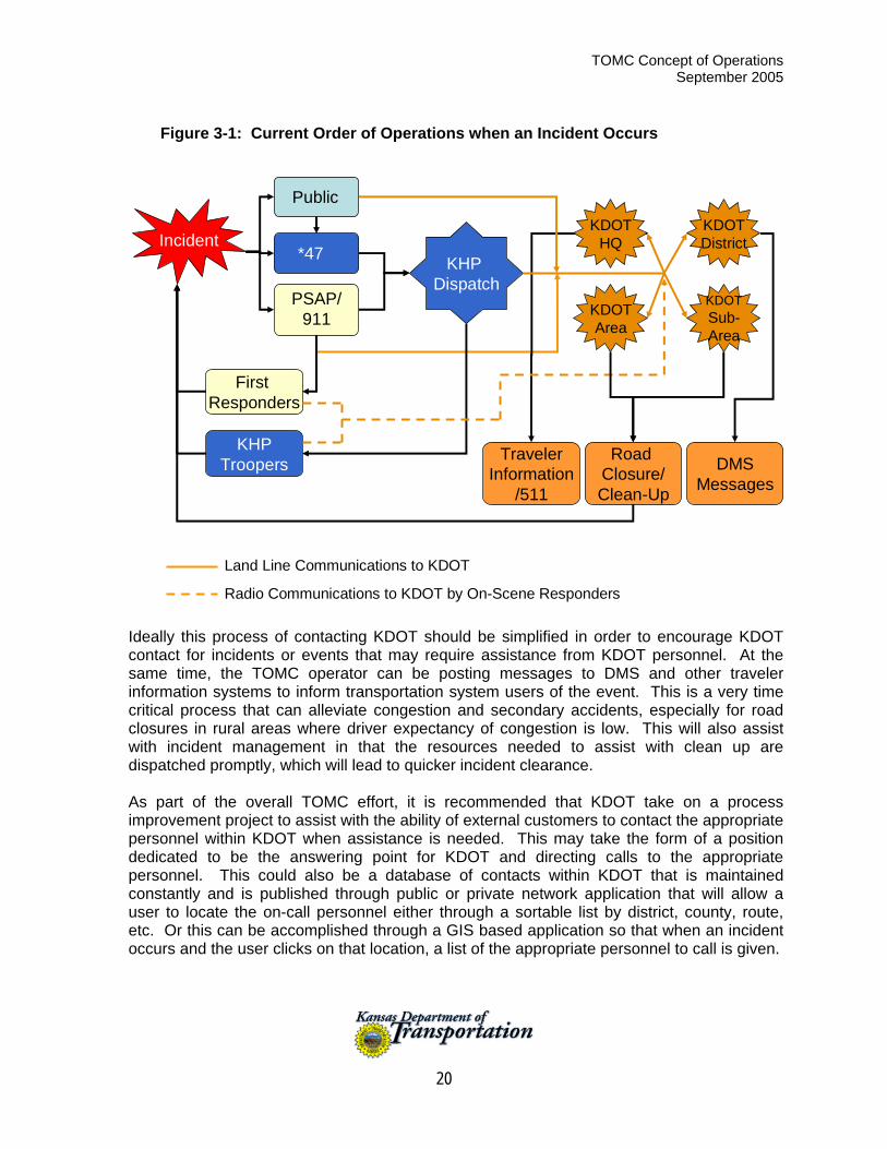
Throughout the stakeholder involvement process conducted by the Project Team during this study, a theme arose related to the various ways that KDOT gets involved when an incident occurs on Kansas highways. The result of the various discussions was that KDOT is contacted by multiple agencies and multiple personnel within those agencies who in turn are contacting multiple personnel within KDOT in order to obtain the proper resources to assist with incident management. The result is that sometimes the wrong person is called, the correct person is called too late, the wrong resources are provided due to miscommunications, or multiple calls are being made for the same resources adding to the confusion. The project team has documented that process in figure 3-1. For the most part, operations run smoothly in Kansas and the existing processes are producing acceptable results, but they are inefficient and have pitfalls, especially when the typical KDOT contacts cannot be located or someone is not familiar with resources available, personnel expertise, who to call, or what resources are needed.
TOMC Concept of Operations September 2005
20
Figure 3-1: Current Order of Operations when an Incident Occurs
KHP Dispatch
Public
Incident*47
PSAP/ 911
First Responders
KHPTroopers DMS
Messages
Road Closure/Clean-Up
TravelerInformation
/511
KDOTHQ
KDOTSub-Area
KDOTDistrict
KDOTArea
Land Line Communications to KDOT
Radio Communications to KDOT by On-Scene Responders Ideally this process of contacting KDOT should be simplified in order to encourage KDOT contact for incidents or events that may require assistance from KDOT personnel. At the same time, the TOMC operator can be posting messages to DMS and other traveler information systems to inform transportation system users of the event. This is a very time critical process that can alleviate congestion and secondary accidents, especially for road closures in rural areas where driver expectancy of congestion is low. This will also assist with incident management in that the resources needed to assist with clean up are dispatched promptly, which will lead to quicker incident clearance. As part of the overall TOMC effort, it is recommended that KDOT take on a process improvement project to assist with the ability of external customers to contact the appropriate personnel within KDOT when assistance is needed. This may take the form of a position dedicated to be the answering point for KDOT and directing calls to the appropriate personnel. This could also be a database of contacts within KDOT that is maintained constantly and is published through public or private network application that will allow a user to locate the on-call personnel either through a sortable list by district, county, route, etc. Or this can be accomplished through a GIS based application so that when an incident occurs and the user clicks on that location, a list of the appropriate personnel to call is given.
TOMC Concept of Operations September 2005
21
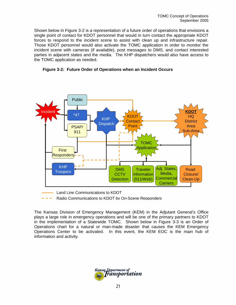
Shown below in Figure 3-2 is a representation of a future order of operations that envisions a single point of contact for KDOT personnel that would in turn contact the appropriate KDOT forces to respond to the incident scene to assist with clean up and infrastructure repair. Those KDOT personnel would also activate the TOMC application in order to monitor the incident scene with cameras (if available), post messages to DMS, and contact interested parties in adjacent states and the media. The KHP dispatchers would also have access to the TOMC application as needed.
Figure 3-2: Future Order of Operations when an Incident Occurs
KHP Dispatch
KDOTHQ
DistrictArea
Sub-Area
Public
Incident*47
PSAP/ 911
First Responders
KHPTroopers Road
Closure/Clean-Up
TravelerInformation(511/Web)
DMSCCTV
Detection
Land Line Communications to KDOTRadio Communications to KDOT by On-Scene Responders
KDOTContact
Point
TOMCApplication
Adj. States,Media,
CommercialCarriers
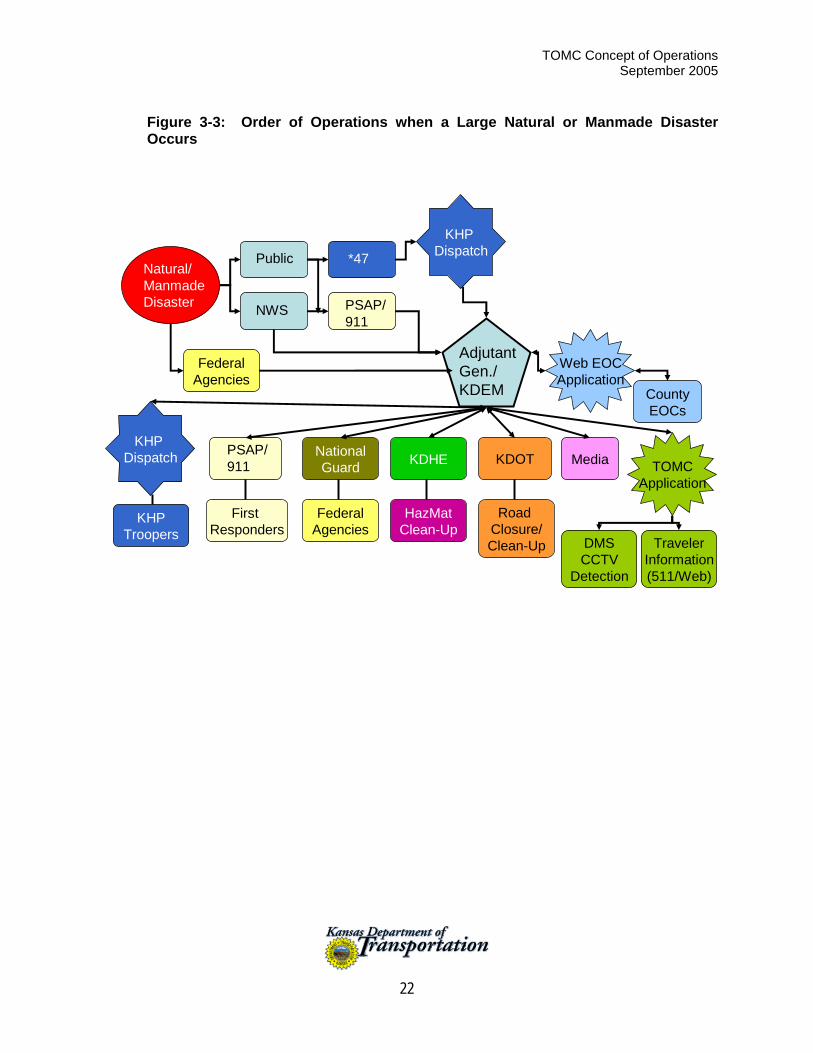
The Kansas Division of Emergency Management (KEM) in the Adjutant General’s Office plays a large role in emergency operations and will be one of the primary partners to KDOT in the implementation of a Statewide TOMC. Shown below in Figure 3-3 is an Order of Operations chart for a natural or man-made disaster that causes the KEM Emergency Operations Center to be activated. In this event, the KEM EOC is the main hub of information and activity.
TOMC Concept of Operations September 2005
22
Figure 3-3: Order of Operations when a Large Natural or Manmade Disaster Occurs
KHP DispatchPublic *47
First Responders
KHPTroopers
Road Closure/Clean-Up Traveler
Information(511/Web)
DMSCCTV
Detection
TOMCApplication
Adjutant Gen./ KDEM
Natural/ Manmade Disaster
KHP Dispatch National
Guard KDHE
HazMatClean-Up
FederalAgencies
NWS PSAP/911
PSAP/911
CountyEOCs
Web EOCApplication
KDOT
FederalAgencies
Media
TOMC Concept of Operations September 2005
23
4 Operational Needs This section of the Concept of Operations describes transportation operations and management needs that were identified through the various stakeholder meetings. Each need is written as a need statement but could also be read as a goal. These statements generate the functions or services and requirements for the TOMC. This section answers the question of what is necessary for KDOT to complement and improve transportation operations and maintenance through a TOMC. Following is a series of needs statements. Section 5 provides information on the functions that are suggested to meet these needs. Section 6 provides operational scenarios for each function to show how they are visualized from the user’s perspective.
Need 1: Improve Inbound Communication with KDOT
Make it easier for outside agencies to contact the right person in KDOT on the first try every time. A variety of agencies need to obtain KDOT services. Occasionally KDOT is needed after normal working hours and weekends/holidays. Agencies expressing this need include:
KHP Salina Central Dispatch KEM County Sheriffs and Emergency Managers
Need 2: Improve Traveler Information Collection
Improve traveler access to consistent and timely road information. Collect information as close to the source of the problem as possible using mobile data entry systems. Existing and new information topics include:
Weather-related road conditions, warnings, closures Work zones, restrictions, detours Incidents, restrictions, detours, delays Evacuation routing Urban travel times Flood warning Conditions in adjacent states Short-term and/or unscheduled restrictions impacting over dimension and HAZMAT
shipments
Need 3: Improve Traveler Information Distribution
Effectively use KDOT and external information distribution resources. Internal and external information sharing resources include:
Internet – KanRoad, KC Scout Telephone – 511 ITS Field Devices – DMS, HAR Other public agencies such as KHP, KEM, local EOCs and adjacent states Private organizations such as KMCA and local media
TOMC Concept of Operations September 2005
24
Need 4: Improve the Effectiveness of KDOT Operations
Provide tools and communications for effective day-to-day, incident, and emergency transportation operations. Operational needs include:
Communication with and control of ITS field devices (DMS, CCTV, HAR, ESS,
Vehicle Detection) Coordination between districts Communication and sharing information with outside agencies and adjacent states,
especially emergency services such as KHP and KEM. Management of vehicle assets through vehicle tracking systems Collection, integration, and sharing historical data Provision of backup operations for emergency closure of KC Scout and other urban
TOC
TOMC Concept of Operations September 2005
25
5 TOMC Overview This section provides a high-level description of the interrelationships of key TOMC components. All of the information contained in this section is described in sections of the document, but this section is designed to focus on the interrelationships among the elements.
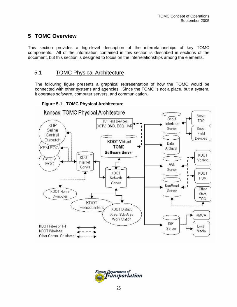
5.1 TOMC Physical Architecture
The following figure presents a graphical representation of how the TOMC would be connected with other systems and agencies. Since the TOMC is not a place, but a system, it operates software, computer servers, and communication.
Figure 5-1: TOMC Physical Architecture

TOMC Concept of Operations September 2005
26
5.2 TOMC Needs and Functions
The following table provides a summary of the TOMC Needs and Functions. Several TOMC Functions address each Need.
Table 5-1: TOMC Functionality as Related to Organizational Needs
Needs
FUNCTIONS
Improve Inbound
Communication with KDOT
Improve Traveler
Information Collection
Improve Traveler
Information Distribution
Improve KDOT
Operations
1. Operate ITS Field Devices X X X 2. Backup Urban TOCs X X X X 3. Respond to Other Agencies X X 4. Use External Information Service
Providers X
5. Archive Transportation Data X 6. Track Extraordinary Trucking X X X 7. Share Information with Other States X X X X 8. Manage Evacuation Traffic X X 9. Collect Road Condition Information X X X 10. Coordinate between KDOT Districts X X 11. Notify KDOT Personnel X X 12. Provide Flood Warning X X 13. Manage KDOT Emergency Assets X 14. Provide Travel Times X X 15. Provide KDOT Estimated Time of
Arrival (ETA) X X
TOMC Concept of Operations September 2005
27
6 Operational Scenarios This section of the Concept of Operations is written from the users’ position, and details how the TOMC would impact user activities under differing conditions, ranging from normal to stress and failure conditions. The operational scenario should tell different stories from perspectives of different user classes over a variety of circumstances. This is a very useful tool in conveying to the reader the event-related usage of the TOMC. It will be through scenarios that the TOMC developer may be able to glean the most information about how to piece the TOMC together – stakeholders and users should be able to easily relate to the TOMC through the ‘story-telling’ means that operational scenarios utilize. There are four basic elements to considering operational scenario development:
Include User’s Perspective Variety of User Classes Stress/Failure Scenarios Multiple Circumstances
During workshops and interviews, the TOMC Stakeholders identified 15 possible functions of the TOMC. Scenarios that relate normal or stress/failure conditions are provided for each function. Some scenarios reflect existing practices/capabilities and others represent future or ideal practices/capabilities.
Function 1: Operate ITS Field Devices
Background Today KDOT districts primarily use portable DMS and HAR to support work zones in the summer and winter maintenance travel advisories in the winter. To date, CCTV is only used by KC Scout in the Kansas City region and through one RWIS station in District 6. The District or Area staff with authority to activate and place messages on these devices uses a computer to “call” the device. The devices usually have a cellular modem. The operator uses the software and the cellular telephone connection to activate the device and select the message to display or broadcast. Scenario 1: Control of DMS and HAR Introduction Each winter some Districts deploy portable DMS and HAR to sites where they will remain until spring. These sites are selected based on the need to tell travelers about hazardous conditions or road closures due to inclement weather. Other Districts have permanent DMS installed.
Scenario 1A: Existing Normal Winter Operations Early Tuesday, a winter storm has developed in eastern Colorado and is heading toward western Kansas. The Area Superintendent in District 3 is monitoring weather forecasts and is in contact with the Colorado DOT to monitor storm progress and road closures.
TOMC Concept of Operations September 2005
28
The Area Superintendent has verified that the Sub-Areas are ready to roll when the storm hits Kansas. At about 10:00 a.m., the storm hits the western counties of Kansas and the Sub-Areas report they are rolling. About 15 minutes later Colorado DOT reports they are forced to close I-70 about 50 miles west of Kansas and requests KDOT to warn travelers. Based on the intensity and progress of the storm, the Area Superintendent decides to close I-70 at Colby. The Area Superintendent activates the DMS located just east of the exits at Colby and Hays, announcing I-70 is closed and that travelers should stop and seek shelter where services are available. The Area Superintendent accesses the DMS software on his desktop computer and activates a total of three signs, one at a time. The software dials the cellular modem on each sign and activates the messages selected by the Superintendent. He also notifies the KHP central dispatch in Salina and local media and enters the appropriate information into the KDOT CDRS. CDRS automatically updates telephone (511) and web-based (www.kanroad.org) traveler information systems. Finally he calls his counterpart in District 2 to activate the sign located just east of Salina. At about 2:00 p.m., Colorado reports that I-70 is reopened for traffic. The Area Superintendent confirms with the Sub-Area Supervisors that Kansas’s roads are in fair to good condition and the storm appears to be abating. The Area Superintendent reviews weather forecasts and decides to reopen I-70 as soon as possible. He accesses the DMS software package on his computer and turns off each DMS. He also notifies KHP Central Dispatch in Salina and local media that I-70 is again open to traffic. He modifies the CDRS entry to the current conditions and calls the Salina District to shut down the sign east of Salina. Scenario 1B: Multiple Winter-Related Events – Holiday Weekend – The Nightmare Scenario (This scenario is written based on current KDOT and KHP organizational structure and operational procedures) After checking the long-range weather forecast, the District Maintenance Engineer approves the Sub-Area Maintenance Supervisor’s request for a long weekend over the New Year’s holiday. This supervisor’s sub-area includes Reno County. The forecasts showed cold and wind but no precipitation was expected. The supervisor left for his family home in Beatrice, Nebraska immediately after his shift ended at 4:00 p.m. on the day before New Year’s Eve. At about 11:00 p.m. on New Year’s Eve, an unusual ice storm began developing east of Hutchinson on US 50. At about midnight, black ice begins to form and an 18-wheeler jackknifes and overturns just outside Sylvia. Three or four cars pile up around the truck and several injuries, including some life-threatening injuries, result from the crash. One motorist involved in the crash calls 911. The Reno County 911 PSAP receives the call at 12:10 a.m. and immediately calls KHP Salina Central Dispatch. The PSAP also calls for ambulance and paramedic services from Hutchinson. The icy conditions continue to worsen and additional 911 calls are received across Reno and Stafford Counties from drivers who have lost control of their cars and need assistance. KHP Salina Central Dispatch immediately dispatches the local Trooper to the scene of the first multi-vehicle
TOMC Concept of Operations September 2005
29
crash. At about 12:20 a.m. the KHP dispatcher makes the first call to KDOT. The Dispatcher uses the call list provided just a few weeks ago. She calls the Sub-Area Superintendent but gets no answer. Meanwhile, the Trooper, who is first on the scene, reports to the Dispatcher that the situation is extremely critical and requests the Dispatcher ask KDOT to close US 50 between Dodge City and Hutchinson. The Trooper also requests the Dispatcher to request assistance from the Reno, Stafford and Edwards County Sheriff’s Departments. The Dispatcher begins calling the Sheriffs for assistance and by the time she attempts to call KDOT again, another 15 minutes have passed. At about 1:00 a.m. the Salina Central Dispatcher calls the second and third names on KDOT’s contact list for the area of the storm impact. She is not able to get a response. At about the same time, the Reno County Sheriff calls the Dispatcher for the KHP Medical Evacuation Helicopter to get a critical victim to the Emergency Trauma Hospital in Wichita. At 1:30, the Dispatcher is able to contact a KDOT Sub-Area Supervisor for Edwards County. He had been asleep and was not aware of the weather or crashes. He began calling maintenance workers to role to their truck stations to load up with salt and sand. He was able to access the portable message sign that had been set near Dodge City but it was facing the wrong direction, so he called one of the workers to turn it around. He was never able to reach someone in Hutchinson to turn on the sign that was located there. The Supervisor realized he was going to have to take charge and began contacting truck drivers in neighboring sub-areas for assistance. He also contacted local media and took time to enter an event into CDRS. He did not know the full extent of the ice storm until about 4:00 a.m. when the truck drivers began to report. The first KDOT truck began to spread salt and sand by 3:00 a.m. The entire route was treated by 5:00 a.m., but not before a total of 14 single and multi-vehicle crashes had occurred with one fatality and seven injuries. KDOT was able to barricade US 50 at Hutchinson and Dodge City at about 6:00 a.m. At about 6:30 a.m. US 281 was closed between Pratt and Great Bend due to icy conditions. KHP requested the road remain closed until 11:00 a.m. on New Years Day to give crash response crews time to clear the victims and wrecked vehicles and for the accident investigation team to complete their field data collection. Scenario 1C: Nightmare Scenario with TOMC The initial events of the scenario unfold as described in Scenario 1B. In this scenario, when the KHP Salina Central Dispatch operator receives the call from the Reno County PSAP, she immediately accesses the KDOT Virtual TOMC interface screen on her workstation. She clicks on the road segment where the incident is reported and selects the type of incident from the drop down menu. In this case she selects icy road, crashes have occurred, road treatment requested and road closure requested. When she presses enter, a cascade of actions occurs simultaneously. Because the Sub-Area Supervisor notified the TOMC system that he was unavailable, the system automatically redirected the call to the next in line in the sub-area and to the adjacent sub-areas. A total of eight KDOT pagers buzzed and beeped at 12:15 a.m. Within 15 minutes, three of the KDOT staff receiving the pages accessed the Virtual TOMC from their home
TOMC Concept of Operations September 2005
30
computers to get an assessment of the problem. The Sub-Area Supervisor for Stafford County indicated he would respond as did the Sub-Area Supervisor from Edwards County. The Supervisor from Stafford County called KHP Salina Central Dispatch to get an update. The Dispatcher connected the supervisor to the Trooper on site. Based on their discussion, the Supervisor selected the “Update CDRS” tab on the TOMC interface. CDRS automatically generated an event report that updated both 511 and the KanRoad website. The Supervisor also selected the “Notify Local Media” tab. He drew a quick circle with his mouse around the problem area and the TOMC immediately notified all the media for the impact area. It was also decided to close US 50. The supervisors began calling their truck drivers and by 1:30 the first trucks began arriving on the scene. The road was treated by 3:00 a.m. Portable DMS were positioned and activated by 2:00 a.m. Due to this accelerated response, most of the crashes reported in Scenario 1B did not happen and US 281 did not need to be closed at all because the roadway was treated in a timely manner.
Function 2: Backup Urban TOCs Background: Scout is proving to be a valuable asset in support of incident verification, response and clearance, and traveler information. If, however, Scout was to become disabled and operators could not utilize its resources, there is no backup communication to the field devices in Kansas or to the communication and video servers in the Scout equipment room. Scenario 2: Statewide TOMC Backs Up Scout TOC
Scenario 2A: Statewide TOMC Takes Over for Scout in an Emergency In early spring a bomb threat was phoned into the Scout TOC. The threat was immediately forwarded to the police who, based on recent elevation of homeland security status to High, advised immediate evacuation of the building. TOC operators complied. The bomb squad arrived about 30 minutes later and began to sweep the building. In the meantime, a severe thunderstorm developed causing minor flooding and several accidents on I-435 and I-35 south and west of Kansas City.
The last thing the Scout lead operator did before leaving the building was advise the KDOT Statewide TOMC contact that Scout was being evacuated and the TOMC should take over monitoring ITS field devices. The Scout operator also advised KHP Salina Dispatch that the TOMC would be handling Scout systems until further notice. Thanks to a recent fiber connection between Scout and TOMC, the TOMC had access to all of Scout’s equipment room servers. TOMC had recently installed duplicate Scout software and was able to initiate communication with and control of all Scout field devices in Kansas. The TOMC manager entered the room to assist with the additional duties. The TOMC operators brought the Kansas freeway cameras up on their video wall. All systems were reporting functional just as the Merriam regional 911 center began receiving calls from crash victims. Merriam operators forwarded calls to KHP and KHP called the TOMC to get verification about crashes and traffic status and to activate DMS at critical locations. Incident response went smoothly.
TOMC Concept of Operations September 2005
31
After about two hours, the bomb squad gave the Scout building the “all clear” and Scout operators returned. The lead operator called KHP and TOMC to let them know they were back on line. The TOMC operators updated Scout operators on the status of the active incidents and Scout took over operation. TOMC shut down the Scout interface and returned to normal operations.
Scenario 2B: Statewide Virtual TOMC Takes Over for Scout in an Emergency This is the same event scenario as Scenario 2A, except that in this case the TOMC is “virtual.”
As the Scout operator left the building due to the bomb scare, he called the KDOT Kansas City Metro Engineer’s office. The office immediately accessed the Scout Intranet site designed for just this purpose. A recent fiber connection between Scout and the Metro Engineer’s office allowed the Area Engineer to see streaming video from each camera. A recent conversion to IP addressable DMS and cameras allowed him to view each camera, control PTZ and put messages on the DMS through an Internet interface. KHP Salina Central Dispatch established an open phone line to the KDOT Metro Office and they proceeded to manage the incidents. KHP viewed camera images that were available through their TOMC interface.
This same scenario could be played out at any KDOT office that was connected to the network and had the internet interface software installed. It would be essential that the person providing backup support to Scout be familiar with the freeway system in the Kansas City area and be trained on camera use and proper DMS messages.
Function 3: Respond to Other Agencies Background: KDOT field staff is highly respected by all the stakeholders participating in the study. KDOT district personnel were commended for their commitment to resolving transportation problems during adverse conditions. At the same time, non-KDOT stakeholders cited numerous examples where attempts to contact KDOT Area and Sub-Area offices had not gone smoothly. Many of the problems occurred outside KDOT normal working hours. Scenarios 1A, 1B, and 1C include difficulties in contacting KDOT. Most KHP difficulties in contacting KDOT were reported to be related to Salina Central Dispatch trying to reach KDOT Area/Sub-Area contacts after hours and weekends. Another reported problem is Salina Central Dispatch contacting the wrong sub-area based on the physical location of the problem. Several speculated that contacting the wrong sub-area was due in part to poor description locations from callers and/or lack of dispatcher familiarity with the local road network. Keeping dispatchers trained on the local road network has been a problem due to dispatcher vacancies and turnover. Local difficulties contacting KDOT were primarily on weekends or evening/holidays. KDOT Areas and Sub-Areas work hard to keep call lists accurate and up to date, but sometimes having to call two or three people on the list before reaching someone in KDOT can cause a problem. At least one stakeholder suggested some communication problems were due to the inexperience of some deputy sheriff staff, particularly in less populated counties.

TOMC Concept of Operations September 2005
32
Scenario 3: HAZMAT Crash over Fourth of July Weekend This scenario is based on an actual event that was reported at the Garden City stakeholder meeting. On the Fourth of July, a truck carrying anhydrous ammonia crashed in a rural area near Garden City and a HAZMAT leak occurred. The County Sheriff was dispatched to the scene and decided traffic should be diverted due to health hazards posed by the HAZMAT leak. He called KDOT’s local Sub-Area office to see if the road could be closed. He was not able reach anyone due to the holiday. Meanwhile the Sheriff in a neighboring county was monitoring the problem, noted KDOT could not be contacted, and called his local Sub-Area office. He was able to reach the Sub-Area Supervisor. The Sub-Area Supervisor worked hard to get information on the problem and where the closure was needed. Based on the information given, he was able to close the road. A short time later, it was determined that he had closed the wrong road. The discussions after the event determined that a combination of events caused the communication breakdowns. There was a need for the on-site person to talk directly to KDOT. It is possible that the TOMC system described in Scenario 1C could have improved communication with KDOT and facilitated a more rapid road closure at the desired location. Function 4: Use External Information Service Providers Background Discussions with KMCA and Kansas Association of Broadcasters (KAB) suggested private organizations are increasingly utilizing Internet and E-Mail systems to share information. E-Mail push systems to news media stations and organizations such as KMCA and AAA Kansas may increase the amount of information that reaches travelers. Highway Watch is a good example of a program that involves truckers and others using and maintaining Kansas highways. The Highway Watch alert program could also be used to alert truckers of major problems, rapidly. Scenario 4: TOMC Activates E-Mail Push System During Major Weather Event Eastbound traffic on I-70 on Memorial Day afternoon was at record levels as vacationers and truckers were heading to Kansas City and points east after the long and particularly nice holiday weekend. About 5:00 p.m. a severe thunderstorm broke out just east of Salina. Within minutes the local 911 center received a call from a motorist about a multi-vehicle crash in the eastbound lane of I-70 east of Salina. Several other calls began to poor into the center and KHP Salina Dispatch was notified of the crash and that I-70 eastbound was closed. The Salina KHP dispatcher used the new KDOT contact interface in their CAD that immediately identified who to contact and sent pager and e-mail messages. As soon as a KDOT Supervisor received the pager alert, he went into his home computer, got on the Internet, and accessed the KDOT TOMC virtual interface. He also called Salina, identified himself and got an update on the incident. After getting a precise location of the crash, he clicked on the advanced traffic management system (ATMS) icon on the TOMC interface. This opened a map that included locations of permanent and portable DMS that could be used to warn traffic. The software also provided a map showing the pre-determined alternate route if I-70 is closed at that point. The ATMS provided an alert, based on the
TOMC Concept of Operations September 2005
33
freeway traffic monitoring station just west of Salina, that traffic volumes were very high with a large percentage of trucks in the traffic stream. The supervisor knew traffic was backing up rapidly in both directions and that the chances for a second crash were very high. He activated the DMS in both directions for 100 miles in either direction. He notified the County Sheriffs along the detour routes to be prepared. He activated an alert system that sent e-mail messages to local media and KMCA. The local media began to provide radio messages. KMCA’s system automatically forwarded the message to their membership. The KDOT supervisor also notified the Kansas Emergency Operations Center. The EOC was monitoring a movement of classified materials and immediately contacted the convoy to take a predetermined alternative route. The supervisor contacted his maintenance workers to close I-70. This notification went out by phone, e-mail and pager. Three responded within five minutes using their wireless personal digital assistants (PDA) that had received both the e-mail and page. The three workers met about 15 minutes later at the truck station. They loaded the barricades and rolled to the designated closure location. The KHP Trooper who had been blocking the road with his car and directing traffic to the off-ramp was glad to see them and they got the barricades in place and installed a portable DMS just prior to the interchange. It took about 45 minutes from the first 911 call until KDOT closed I-70. The one lead worker sent an e-mail to the supervisor from his PDA indicating the road closure and alternate route was in place. In a debriefing after the incident, KDOT and KHP discussed the overall incident response. It was determined that the quick activation of the DMS and other traveler alert systems greatly deceased the backup on I-70 and that traffic on the primary detour route was not as heavy as expected. Traffic diverted to other routes or just stopped to eat or at rest areas until the incident was clear. The KDOT Public Involvement Liaison conducted a survey of restaurants and truck stops as far west as Colby. All of them reported a significant increase of customers within 15 to 30 minutes of the start of the event. When asked what they attributed the change in travel, the owners said their customers were talking about 511, DMS and alerts they heard on the radio. A few even mentioned they heard about I-70 being closed with their Satellite radio traffic channel on the newly activated “Heartland Traffic Channel”. Function 5: Archive Transportation Data Background KDOT’s Bureau of Transportation Planning is developing a GIS interface to all KDOT information that is on-line. The vision is for ITS data, including volume, speed, occupancy, and classifications of vehicles along with weather data, AVL data, and maintenance management systems data (with the probable exception of full motion historical video images) would be archived to use for planning, design, and operations. Access to accurate archived vehicle data is, for example, a necessary foundation for predicting current travel times during both normal and adverse conditions. Scenario 5: Archived Data Clears KDOT Transportation Workers KDOT had been archiving snowplow route information from the first days of implementing automatic vehicle location on their snowplows. This information tracks snowplow routes, direction of travel, salt and sand application and other parameters. The data is used each year to plan snow removal for a variety of weather conditions to optimize KDOT’s productivity and minimize the amount of chemicals released into the environment.
TOMC Concept of Operations September 2005
34
Early on a January morning, the Chautauqua County 911 Center receives a call from a traveler who said they had run off the road into a ravine just north of Sedan on K-99. The 911 operator logged the call at 9:12 a.m. The 911 operator dispatched a tow truck and an ambulance. About two weeks later, KDOT’s Office of Chief Counsel received a notice of a tort claim in the amount of $500,000. The claim says a motorist was driven off K-99 at 9:05 a.m. because the driver was avoiding a KDOT truck that was driving on the wrong side of the road. The claim did not identify the truck or license plate number of the KDOT truck. The KDOT Office of Chief Counsel immediately contacted each sub-area supervisor in the vicinity of the incident. One sub-area reported that maintenance logs indicated that several trucks were cleaning snow from guardrail in Elk and Chautauqua Counties. He provided the names and truck numbers of each maintenance worker. Two drivers remembered working on K-99 that day, but they were not sure of the time. Neither recalled driving on the wrong side of the road or encountering a car that had run off the road. The Office of Chief Counsel then downloaded records from the on-line ITS archival system for the AVL-GPS information on all trucks in the sub-area. The GPS traces of the KDOT trucks showed two trucks had worked on K-99 but not until early afternoon that same day. All trucks in the sub-area were accounted for on the GPS trace. The tort case was withdrawn. Function 6: Track Extraordinary Trucking Background This was probably the only TOMC function that was in any way controversial. Emergency managers, work zone managers, and event planners all expressed the desire to know when HAZMAT, OS/OW and super loads were on the road and where they were headed. While the KDOT permitting process works quite well for normal operations and long-term work zones, opinions were expressed that short term work zones or unplanned events can cause problems. On the other hand, the KMCA, speaking on behalf of commercial trucking, expressed the opinion that most truckers did not want government to track their vehicles as they move across the county, except in the case of an emergency. KMCA also expressed the doubt that government would want to track all HAZMAT vehicles since the number of trucks carrying potentially hazardous materials would be overwhelming. For example, a load of household cleaning products could be classified as HAZMAT if the cargo spilled and individual bottles began to leak into the environment. Scenario 6: TOMC and KanRoad Creates Daily Alerts and Hourly Updates to HAZMAT and OS/OW Haulers. KDOT recently instituted a policy that haulers receiving annual permits for OS/OW and HAZMAT loads would need to have the capability to receive and respond to real-time messages from KDOT about road closures or restrictions. On Friday morning last summer, the Sub-Area Supervisor received a report that a column supporting the US 281 bridge over a local road had been hit by a vehicle and a small crack had formed, possibly reducing the structural capacity of the bridge. He called the bridge office in Topeka. They advised him to post the bridge at a reduced load until an inspection
TOMC Concept of Operations September 2005
35
could be performed. The bridge inspection crew would not be able to inspect the bridge until the following day. This route is often used to haul OS/OW loads. Upon getting the advice from Topeka, the supervisor put a notice in the commercial trucking pages of KanRoad. This notice caused an immediate e-mail to all OS/OW shippers that were approved to use US 281. The e-mail contained the clause that all permits for US 281 were cancelled unless the hauler acknowledged the e-mail with the statement that they would avoid US 281 between US 50 and US 56. Within two hours, the permit department received an acknowledgement from all but one OS/OW hauler. The permit department contacted the hauler that their permit was invalid until further notice. It was later determined that the bridge was not severely damaged. The KanRoad alert was cancelled, immediately notifying the OS/OW haulers. Function 7: Share Information with Other States Background KDOT is a member of the High Plains Coalition (HPC). This group of states is developing plans to share information to improve traveler information and agency response to weather and other incidents. This same information can be shared with adjacent states that are not part of the HPC. Scenario 7: HPC TOMC Interface Improves Regional Traveler Information In 2007, Kansas along with Missouri, Colorado, Iowa, Nebraska and Wyoming created the High Plains traveler information program (HIPTIP). This program resulted from creating an automatic feed from the TOMC server and the KanRoad server to the HIPTIP. The feeds from the TOMC allowed HIPTIP operators in other states to view KDOT DMS messages and CCTV images and well as road and environmental sensor data. The other states provided similar connections to HIPTIP. One institutional issue that slowed the implementation of HIPTIP for almost a year was the need to develop an agreement on common thresholds for the road condition definitions in the data dictionary. In March of 2008, a winter storm began in Western Colorado. Data that the CDOT TMC operators entered into the road condition system was automatically integrated into HIPTIP. Kansas KanRoad collected information from HIPTIP and began to include messages in 511 and the KanRoad website. The Area Superintendents in western Kansas kept an eye on the HIPTIP information and used it to decide when to activate the snowplows. The Area Superintendents also placed messages on DMS as CDOT began to close sections of highways closer to Kansas. HIPTIP was also monitored by statewide TMCs as far east as Illinois. Illinois, Iowa and Missouri TMCs alerted interstate trucking to be aware of road closures in Kansas, Nebraska and Colorado and to take alternative routes. Function 8: Manage Evacuation Traffic Background Up to date and accurate information on road congestion, incidents, restrictions and closures is necessary to provide effective evacuation routing services.
TOMC Concept of Operations September 2005
36
Scenario 8: Derailment of HAZMAT Tankers Causes Evacuation of Most of Johnson County A BNSF train derailed as it was moving through Olathe near Interstate 35. The 911 Center in Merriam received the call at about 6:30 p.m. After dispatching local police and fire, the Merriam operator received reports of a large rupture in a tank car suspected of carrying chlorine gas. The operator immediately called the KEM EOC, local and state HAZMAT response teams, and the KHP. The first members of the HAZMAT team arrived at about 6:45 p.m. and it was determined that chlorine gas was leaking. Based on the wind direction and speed, the HAZMAT team requested evacuation of portions of Olathe and Overland Park and diverted traffic away from the evacuation area. The KDOT liaison within the KEM EOC immediately activated the KDOT TOMC Interface and issued an emergency notification to all District Supervisors in KDOT Districts 1 and 4. The TOMC already showed all road closures and restrictions due to work zones. Within 15 minutes, nearly all KDOT supervisors had responded. The KEM-EOC KDOT liaison advised KDOT District forces to take up checkpoints along evacuation routes to the west and south of Johnson County and to report conditions every 10 minutes. At the same time, KEM-EOC activated the Emergency Broadcast system and began to tell people to evacuate their homes and business. Depending on what part of the impact area they lived in, they were assigned an evacuation route. People on the west side of the impact area were advised to head toward Lawrence and Topeka, people in the south west part were advised to head toward Ottawa and Emporia. People on the east side were instruction to head toward Iola and Fort Scott. KTA was advised to waive all tolling operations to allow the evacuation to proceed smoothly. KDOT forces, in groups of two, were distributed to key junctions along the detour routes. One person was assigned the task of providing updates to the TOMC through his mobile data computer TOMC Interface. The other person monitored radio and CB. If a breakdown occurred in the vicinity, he moved in that direction to help clear the disabled vehicle as soon as possible. At about 8:00 p.m. it was reported by KDOT field units that US 169 was completely stopped at the junction with K-68. Using the EMS, KEM-EOC advised people evacuating along that route to divert east to US 69 or west to I-35. At about 9:30 p.m., police and sheriff deputies reported to KEM that the evacuation was about 100% complete and they were taking up positions and patrols to prevent vandalism and looting. At about 10:00 p.m., KDOT field units began to report that road conditions had returned to about normal levels and that they were standing by for further instructions. At about 11:00 p.m., the HAZMAT team reported that all leaks had been stopped and air quality had returned to safe levels. KEM-EOC notified the emergency responders and KDOT that the announcement to return would be going out on the EBS and they should take up their positions for the return trips. The return traffic was heavy but not as heavy as the evacuation. Many people decided to stay overnight with relatives or in a motel. KDOT’s last update to the mobile interface to the TOMC was at 12:30 a.m., that all roads were functioning well. At that time about ¾ of KDOT field forces returned home, with the remaining to provide quick response in the case of an incident.
TOMC Concept of Operations September 2005
37
Function 9: Collect Road Condition Information Background Several stakeholders suggested that entry of data into KanRoad is not always consistent. There is a reported feeling that some maintenance workers believe supervisors use KanRoad to rate snow removal performance. Where this feeling persists, workers may be tempted to report better than actual conditions to make sure they are not perceived as performing below average. Another group of maintenance workers tend to over generalize road conditions, usually on the conservative side of actual conditions. This group would be tempted to report the worst observed condition as the condition for all the roads in the sub-area, even though many of the roads or road segments were in substantially better condition. Other examples of KanRoad data problems included timeliness of data entry especially for unscheduled maintenance lane closures, short-term weather conditions, and traffic incidents such as crashes that block a lane or close a roadway. Some stakeholders also mentioned clearing of events as a problem. KDOT’s ATIS unit does routine quality control checks of KanRoad data but one person can not perform this task continuously. Several stakeholders also expressed concern that their number one priority was keeping KDOT personnel and equipment engaged in field activities. Any record-keeping or other responsibilities that reduce the amount of time KDOT is providing customer service should be avoided. Scenario 9: Automated data collection system improves traveler information and allows maintenance truck driver to focus on keeping the truck on the road. In 2008, KDOT installed several new technologies on maintenance trucks in two sub areas as a pilot. These systems included:
Vehicle tracking Plow-up, plow-down tracking Spreader on-off Spreader volume measurement Pavement temperature sensor Pavement surface moisture sensor Wheel friction sensor Visibility measurement sensor Two-way data communication
These systems were intended to reduce operator-reporting requirements, to automate road condition information, and to keep the trucks on the road for a greater percentage of time during each shift. A major snow event began to expand into the pilot districts in early January. Based on the forecasts, it was determined that at least a 10-hour shift would be necessary to manage the
TOMC Concept of Operations September 2005
38
snow and keep major roads open to traffic. The sub-areas began pre-treatment about two hours before the snow and continued plowing and distribution of chemicals throughout the storm. Except for reloading and mandatory breaks, the trucks were on the road 100% of their availability. As plowing was commencing, the on-board sensors began to collect and report data to the TOMC servers. Based on a combination of factors, road conditions were reported as “poor” even after the trucks had completed a route. The reason for the poor ratings was based on limited visibility due to blowing snow and the readings from the friction sensors. The poor ratings were transferred to KanRoad, 511 and the website. Media and traveler information systems were reporting poor road conditions and only emergency travel recommended. Towards the end of the snow event, road conditions as reported by the vehicle sensors began to improve from poor to fair or good driving conditions and travel advisories were lifted. After the event was over, the sub-area supervisors noted that records showed two trucks seemed to place substantially more chemicals than the amounts that were determined as applicable based on the snow forecast and measured conditions. The trucks were checked and one was determined to have a faulty spreader and the other was determined to have a faulty spreader sensor. Truck drivers commented that there seemed to be fewer cars on the road and fewer cars in the ditch compared to other snow events of this type. This meant that they were able to keep moving with fewer interruptions to their routes. Based on the feedback line on the 511 system and on the website, many travelers decided to delay their trips based on road conditions reported by the automatic system. Function 10: Coordinate between KDOT Districts Background Today, KDOT Sub-Area Supervisors must depend largely on phones and KDOT voice radios to coordinate activities across multiple Districts, Areas, and Sub-Areas. In the future, vehicle tracking integrated with advanced weather tracking will provide instant access to event response and regional weather efforts. Scenario 10: TOMC Provides for balanced response to major regional snowstorm. The National Weather Service activated a winter storm warning that included all the counties in the eastern half of Kansas. The snow was expected to be heavy accompanied by strong winds. KDOT used its weather forecast system to get additional information on the expected path and width of storm. All Areas in Districts 4 and 5 were alerted. As the storm developed, it was as severe as expected and snow was falling at about two inches per hour on a north-south band between Hutchinson and Arkansas City, moving to the east at about 20 miles per hour. The storm continued at that intensity for about two hours then began to abate on the edges but continued in the middle of the band for another couple of hours.
TOMC Concept of Operations September 2005
39
Area Superintendents and District Maintenance Engineers used the TOMC vehicle tracking system to monitor snow removal progress. As roads began to be cleared on the edges of the storm in District 5, those drivers were directed to assist with efforts near the center of the storm in the western portion of District 4. In the end, all roads were cleared to “spots snowpacked/ice” condition – except a few spots covered with blowing snow – within two hours of the end of the snow event. Decisions on road conditions were made as on-board sensors began to report road conditions based on visibility, friction, and snowplow progress. Function 11: Notify KDOT Personnel Background Traffic crashes often involve KDOT-owned roadside facilities such as signs, light poles, guardrail, or other safety devices. Kansas law requires drivers causing damage to KDOT facilities to pay for the repair. Also, if a stop sign or other traffic control device or warning sign is damaged, another crash could occur. Scenario 11: KDOT TOMC Integration with KHP Digital Accident Investigation System In October a grain truck hauling wheat to an elevator in Salina swerved to miss a car running a stop sign. In the process the truck veered to the right, overturned and knocked over the stop sign on the south approach to K-18 near Lincoln. Most of the grain spilled, and while not immediately noticed, blocked the drainage culvert under the county road. KHP Salina Central Dispatch received the 911 call forwarded from the Lincoln County 911 PSAP. Salina immediately dispatched a trooper to the scene. The Trooper used his recently installed accident investigation portable computer to gather the details of the accident. The system included a bar code scanner with which the trooper scanned the bar code on the stop sign that was laying about 50 yards from the crash site. He also described the crash site including the location of the spilled grain. About 30-minutes later, the trooper pressed “send” on the accident report system and the KHP data channel immediately transmitted the report to Salina. Since the report included a KDOT stop sign, relevant fields of the crash report were immediately and automatically shared with KDOT’ s TOMC. The TOMC sent the information on the stop sign to the appropriate sign crew and to KDOT Loss Management Office. The sign crew received the alert on the foreman’s portable TOMC interface unit and immediately sent two workers to replace the sign. Since the sign was knocked down, KDOT’ costs to replace the sign were automatically recorded and forwarded to Loss Management. The sign was replaced within 45 minutes of KHP filing the report. While on-site rain had started and the sign crew observed the grain blocking the culvert and water beginning to overtop the roadway. The Crew notified the foreman and began to shovel the grain to allow water to go through the culvert. It took about two hours for the crew to clear enough grain to get the water to flow normally. Total time spent replacing the sign and clearing the grain were collected on KDOT’s electronic time accounting system and reported to Loss Management. Loss Management had all the costs needed for the grain hauler’s insurance company within two weeks of the crash and submitted the bill with documentation.
TOMC Concept of Operations September 2005
40
Function 12: Provide Flood Warning Background Some automated flood warning systems exist in the KC metro area. This system includes water level gages and flood prediction algorithms. When a flood is possible, the emergency broadcast system is activated in the same way it is activated for severe weather alerts. The emergency broadcast system uses the commercial radio and television broadcasts to distribute emergency notifications. However, many travelers have their radios off or are listing to tapes, CDs, or satellite radio. Scenario 12: KDOT TOMC Activates Traveler Information Systems to Provide Flood Warning On July 14 at 10:00 p.m., the weather forecast was predicting heavy rain and possible flash flooding in southeast Kansas for the next morning. The weather forecast interface with the TOMC automatically created an alert that was sent to all Area and Sub-Area Supervisors in the warning area. The supervisors were familiar with the routes that experienced flooding and deployed portable DMS at junctions on either side of the potential flood area. When the rain started at about 4:00 a.m., KDOT assigned flood watchers to critical streams and had units waiting on standby to deploy barricades if a route needed to be closed. At about 5:00 a.m., the flood watchers reported rapidly rising water in two streams. Using the TOMC mobile interface, the Sub-Area supervisors activated the DMS altering travelers to the possibility of flooding. At 6:30 a.m., the flood watchers noted that water was on the shoulders at one location and still rising. KDOT immediately changed the DMS for that route to read “Road Closed” “Flooding” and installed barricades. KanRoad was also updated as was 511. The County EOC’s were monitoring the KDOT TOMC user interface and noted which state roads were being closed. Sheriffs’ deputies were dispatched to observe local roads and provide closures as needed. The rain stopped at about 8:00 a.m. Flooding abated at about 9:30 a.m. Roads were reopened and DMS messages were changed to alert travelers of the possibility of debris on the roadway and of workers removing debris. By noon KDOT’s field units report that all roads are in normal condition and that all DMS are off and all barricades removed. KanRoad and 511 are updated simultaneously. Function 13: Manage KDOT Emergency Assets Background The Kansas Department of Emergency Management (KEM) is responsible for coordinating multi-agency response to major emergencies and disasters. A key element of that response is knowing agency personnel and equipment availability and locations in order to effectively manage assignment of these assets as needed. During an emergency KEM has a statewide perspective and can make emergency asset management decisions based on the overall need compared to the needs at a specific locality. Web EOC has the capability to track vehicles if GPS location is communicated from the vehicle to the KEM EOC in Topeka. Scenario 13: KDOT AVL improves KEM efforts to respond to tornadoes and flooding in south central Kansas On a Saturday in May, the national weather service issues a serve thunderstorm and tornado warning for north central Oklahoma and south central Kansas. Upon receiving the

TOMC Concept of Operations September 2005
41
warning, KEM’s EOC was put on active status and an operator assigned to monitor the situation. KEM alerted the EOC’s in the warning area to be on standby as well. At about 1:00 p.m., reports of the first tornados reached the KEM EOC and the County EOCs. The KEM EOC operator sent a request to KDOT’s TOMC and other state agencies for assistance in responding to the disaster. KDOT’s TOMC immediately generated pager, e-mail and phone messages to Sub-Area Supervisors. Within 15 minutes of the TOMC messages, nearly all the supervisors confirmed receipt of the message with the KDOT liaison at the KEM EOC. The Supervisors began calling maintenance workers to head to the truck stations, turn on their vehicles AVL system and wait for further instructions. Within an hour nearly 250 maintenance workers had reached their truck stations and activated their AVL units. The KEM EOC operator was already accessing the TOMC vehicle location interface. By 3:00 p.m., 8 tornadoes had been reported, five towns had been hit hard and flooding was being reported. KEM EOC reviewed the location of the damage and requested KDOT have their closest KDOT supervisors to roll their trucks to various sites. Trucks began arriving on the scene within 30 minutes of the call to move. KDOT drivers began to push debris off the road to facilitate access of emergency vehicles. KDOT began to put warning signs and closing flooded roadway sections and reported the closures to KEM-EOC. KEM-EOC used the information to route emergency vehicles to the damaged towns and rural residences. As KDOT resources moved closer to the center of the impact area, the drivers began to report increased debris and difficulty clearing the roads. Upon hearing the reports, the KDOT liaison in the EOC alerted additional KDOT Sub-Area Supervisors in surrounding counties. As responses came, the EOC directed them to the hardest hit areas to assist with road clearing and debris cleanup. As crews in lighter hit areas began to report, KDOT EOC staff directed them as needed keeping close watch on impact zones and truck locations to provide support wherever there was a need. In previous storms of this type, KDOT personnel would have done what ever they could see that needed to be done. However, this approach often resulted in too many resources at one site and not enough somewhere else. By coordinating the TOMC vehicle tracking system with KEM’s Web EOC, KDOT resources could be used very effectively. Function 14: Provide Travel Times Background The Kansas Motor Carriers Association and other stakeholders expressed the need for travel time information, especially when travel times were highly variable such as in work zones, through incident sites, and congested areas in the Kansas City urban area. State DOTs provide freeway travel times in some urban areas such as in Atlanta and San Antonio. DOTs most often use system detectors to calculate travel times. Private information service providers often provide freeway travel times based on observation. The automobile industry is also installing “black box” recording devices and AVL on most passenger cars. Some have suggested that these recorders and dedicated short-range communication between the vehicles and the roadside could be used to measure travel times. The vehicle could transmit average speed for the past mile or two. The road agency or the information service provider could convert this information to travel time reports and estimates.
TOMC Concept of Operations September 2005
42
Scenario 14: KDOT Provides Travel Times in Work Zones KDOT implemented a 12-mile work zone on I-70 between Abilene and Salina. Traffic was detoured one lane in each direction on the westbound lanes. Within days, complaints were received about the slow traffic and long travel times through the work zone. KDOT worked with the contractor to install speed detectors and CCTV cameras at one-mile increments throughout the project. The detectors communicated wirelessly to the KDOT project office. The project office was connected wirelessly to portable DMS at each end of the project. The TOMC application was updated to show the new portable DMS and displayed travel times. As traffic slowed below the posted work zone speed limit, the work zone system computed the average travel time through the work zone. The system activated the DMS with travel time messages. The system also posted messages to KanRoad. KanRoad automatically updated 511 and the web site. The system worked fairly well and complaints stopped. At about 4:00 p.m. on Friday of the last week of college classes before break, record high traffic volumes caused I-70 to slow to a crawl with travel times of up to one and one-half hours reported by the system. Based on these long travel times, the TOMC operator activated additional DMS as far west as Colby and as far east as the KC metro area. Scout activated a DMS on I-70 east of the I-470 interchange. The extreme travel times continued until about 8:30 p.m. at which time the delays were about normal for that time of day. A week later, KDOT asked KMCA if they could do a quick survey of their members to determine how the trucking industry responded to KDOT’s efforts to warn travelers of the delay. KMCA agreed and sent e-mail to its membership. Within a few days KMCA began forwarding responses to the KDOT TOMC. By far the most frequent response from those that had seen the signs or gotten the information some other way were grateful. Many truckers decided to stop for dinner or sleep to avoid the delay. Function 15: Provide KDOT Estimated Time of Arrival (ETA) Background KDOT is planning to add vehicle tracking and mobile data computers to maintenance and KHP vehicles once the 800 MHz digital trunked radio system is operational. The 800 MHz will include a data channel for communication between the statewide TOMC and vehicles. At the regional stakeholder meetings held in 2004, participants discussed incidents where KHP had asked KDOT for some sand or salt. The Trooper in the field had to wait “a long time” before KDOT arrived. The waiting time seemed longer because the Trooper did not know for sure when KDOT was arriving or the KDOT ETA. Stakeholders believed a system that allowed the Trooper to “see” the progress of the KDOT vehicle on his mobile data computer would alleviate the anxiety of not knowing the ETA. Scenario 15: AVL/MDC System Improves KDOT/KHP Communication In February a minor crash occurred on US 75 about one mile north of Holton. KHP Salina Central Dispatch received the call from the Jackson County 911 center at about 8:30 a.m. Salina dispatched Trooper Smith who arrived on the scene at about 8:40 a.m. Trooper Smith found everyone was okay but called for a tow truck. Trooper Smith also noted an icy patch on the road that may have contributed to the crash and asked Salina to call KDOT to send salt and sand to melt the ice.
TOMC Concept of Operations September 2005
43
KDOT received the call at about 8:55 a.m. The KDOT Sub-Area Supervisor noted on his vehicle tracking system that the three closest trucks were all out of spreading material. Another truck was about 20 miles away but had recently refilled with sand/salt mixture. The supervisor decided to have one of the empty trucks refill and respond to KHP and so advised the driver. The supervisor then activated the “KHP” tab on the vehicle tracking system. That tab immediately transmitted the location of the vehicle to KHP’s mobile data system. The supervisor notified Salina who in turn notified Trooper Smith. Trooper Smith activated the KDOT tab on his map and was able to see the progress of the KDOT truck that was responding to his incident. He watched as the truck went to the truck station, filled with sand, and got back on the road. At about 9:15 a.m., KHP Dispatch notified the Trooper that another crash had occurred on US 73 near Huron and asked his status with the current crash. The Trooper reported the tow truck had arrived but KDOT’s truck was about five miles away according to his mobile data computer. Based on that information, Salina determined that the Trooper should respond to the crash as soon as KDOT was on the scene and spreading sand. Salina activated the KHP-KDOT channel on the vehicle radios. Trooper Smith called the KDOT truck driver who responded that he was just “coming out of Holton.” Trooper Smith looked for approaching traffic and saw the truck. Trooper Smith left for the second crash site and described the icy patch to the KDOT driver as he proceeded north. KDOT began spreading sand at about 10:05 a.m.
TOMC Concept of Operations September 2005
44
7 The Operational and Support Environments This section describes the environment or “world” in which the TOMC will operate. This section includes information about the TOMC’s environment in terms of the following categories:
Facilities Hardware Software Personnel Communication Needs
The information in this section is based on stakeholder feedback, past experience of the Project Team, and Project Steering Committee input. This section summarizes the information contained in the Statewide TOMC Implementation Plan. For additional detail, please refer to that document.
7.1 Facilities One of the reasons that the Virtual TOMC concept was selected was to minimize space impacts and eliminate the need for a dedicated facility or building to house the TOMC. It is envisioned that the TOMC application will be installed on work station computers that will utilize existing office spaces and desks. These work stations will be located in each District, likely at the District headquarters building. The designated operator can utilize their existing office to house the work station or a dedicated desk/office can be used. It will be up to each District to determine what configuration works best. At KDOT headquarters, the work station can be located in a designated office, most likely the responsibility of the Division of Operations. In addition, KDOT may desire to load the application on a portable workstation that could be used in a conference room for demonstration purposes or for events requiring a group of decision makers to gather. Partner agencies such as the Kansas Highway Patrol may wish to locate their workstation at the Salina dispatch center in the dispatch room for easy access. The Kansas Division of Emergency Management may wish to locate their workstation in their main conference room for gathering officials in the event of a statewide emergency. The computer servers will require space in a KDOT equipment room and will probably be installed in existing server racks without need for additional space. If additional space is required, KDOT should plan on two racks to provide space for the TOMC software server, a communications server, and a video server along with the associated cabling. In addition, if CCTV communications are to be district based, room for a video server should be planned in each district office.
7.2 Hardware
7.2.1 Typical TOMC Hardware Requirements The primary new hardware required for the TOMC will be central servers designed to support the TOMC software application. The number of servers required will be based on the software requirements for the TOMC, but a typical system might require as many as three servers to support all of the subsystems needed to provide statewide
TOMC Concept of Operations September 2005
45
operations. Secondary servers to support communication, archiving, and sharing of information with partner agencies and organizations will also be needed. A typical system would require the following minimum server specifications: One (1) Database Server • Dell Power Edge 2850 • Intel® Xeon™ processor at 3.2GHz/1MB Cache, 800MHz FSB • 2GB DDR2 400MHz (4X512MB), Single Ranked DIMMs • 3 36GB Drives attached to embedded PERC4ei, RAID 5 • Dual On-Board NICs • Windows 2003 Server, Standard Edition with Client Licenses • 24X IDE CD-RW/DVD ROM Drive for PowerEdge Servers • Embedded RAID (ROMB) - PERC4ei (Embedded Integrated) • Riser with PCI-X Support and Embedded Raid (ROMB) Support • Controller Card SCSI, 39160 Internal/External, U3, Low Voltage Differential • 3Yr BRONZE Support, Next Business Day Onsite • Keyboard / Mouse • Dell E173FP Digital Flat Panel Panel Monitor,17 inch(17in Viewable) • Rack Chassis w/Versarail, RoundHole-Universal • Rapid Rails, Square Hole (Replacement for versa)
Two (2) Network / Communications / Video Servers • Dell Power Edge 2850 • Intel® Xeon™ processor at 3.2GHz/1MB Cache, 800MHz FSB • 2GB DDR2 400MHz (4X512MB), Single Ranked DIMMs • 3 36GB Drives attached to embedded PERC4ei, RAID 5 • Dual On-Board NICs • Windows 2003 Server, Standard Edition with 5 Client Licenses • 24X IDE CD-RW/DVD ROM Drive for PowerEdge Servers • Embedded RAID (ROMB) - PERC4ei (Embedded Integrated) • Riser with PCI-X Support and Embedded Raid (ROMB) Support • 3Yr BRONZE Support, Next Business Day Onsite • Rack Chassis w/Versarail, RoundHole-Universal • Rapid Rails, Square Hole (Replacement for versa)
It is KDOT’s desire to have the TOMC servers and software reside in a central location, likely KDOT Computer Services in Topeka. For the TOMC software application, space for one server rack will be required in the central location. Communications equipment required will be based on ITS infrastructure in the field as will a video server with specifications based on the simultaneous video usage needed at the District offices. Space for these equipment racks, minimum 1, and the associated cabling, will be needed in headquarters and in the District office if field communications are routed through the District offices. In order to run a typical COTS application, a PC with the following minimum recommended specifications is required: Operator Interface (Workstations) • Dell Precision Workstation 370 Minitower
TOMC Concept of Operations September 2005
46
• Intel® Pentium® 4 Processor 3.00GHz, 1MB/800 • Microsoft® Windows® XP Professional, SP2 with Media • 512MB, 533MHz, DDR2 SDRAM Memory, ECC (2 DIMMS) • C1 All SATA drives, Non-RAID, 1 or 2 drive total configuration • 80GB SATA, 7200 RPM Hard Drive with 8MB DataBurst Cache™ • 48X/32X CD-RW/DVD Combo w/ CyberLink PowerDVD • 64MB PCIe x16 nVidia Quadro NVS 280, Dual DVI/VGA Capable • Sound Blaster Audigy™ 2 (D), w/Dolby Digital 5.1 & IEEE1394a • Serial Port Adapter • Keyboard • Mouse • Dell Two Piece Stereo System • Dell 19 inch UltraSharp™ Flat Panel, adjustable stand, VGA/DVI These workstations are on the high-performance end and one should be supplied to each District (6), KDOT HQ (1), and partner agencies (2) as the main interface with the TOMC application for a total of 9 initially. Most modern workstations will be satisfactory to run a COTS application.
7.3 Software
7.3.1 TOMC Software Requirements The TOMC is intended to be a software application that runs on a common server and is accessible through KDOT’s existing networks for KDOT users statewide and to KDOT agency and private partners. Users will be provided user names and passwords. Level of access will depend on permissions assigned within the software for each user. KDOT users will have the highest level of access while partner agencies and organizations will have more restricted access. The software must address the 15 TOMC functional requirements as well as certain basic requirements. These basic requirements include:
• Support center to center (C2C) and center to field (C2F) communication • Scalable, upgradeable, and modular design • Compliant with NTCIP • Able to communicate with devices from different vendors • Able to handle different signal formats (NTSC, PAL etc) • Share real time information over WAN / LAN • Support multi-user multi-priority level access • Backup operations at other centers • Allow user access from remote terminals
7.3.2 TOMC Software Model There are several ways to implement TOMC software: purchase a statewide license for “commercial off-the-shelf” or COTS software; acquire “freeware” and utilize a programmer to customize it for KDOT’s use; utilize a programmer to develop new software; or, modify existing KDOT software such as KanRoad. The key to selection of software will be functionality relative to the 15 TOMC functions, costs and timeframe for implementation. It will also be necessary to determine how long-term support for the
TOMC Concept of Operations September 2005
47
software will be provided. Will KDOT be able to support the software in-house or will vendor support be required?
7.4 Personnel Staffing hours for the Kansas Statewide TOMC will be highly variable. Factors that influence staffing hours include: Complexity or simplicity of TOMC user interface related to the TOMC functionality. Types and quantities of integrated ITS field devices available to TOMC users. Intensity of active events, incidents and/or emergencies. Need for KDOT or other partner participation in a particular event. KDOT policies on frequency and timeliness for updates to messages on DMS and
HAR and for providing messages and updates to external partners. Centralization (Statewide or District) or decentralization (Area, Sub-Area,
Maintenance Worker) of TOMC monitoring, control, and input responsibilities. Frequency, scope, and duration of system and communication tests and diagnostics. Reliable or frequently maintained or repaired communication, ITS field devices, and
networks. Availability of staff and budget to monitor TOMC functions. Availability of key staff after hours or on-call staff to monitor TOMC functions. Ability for TOMC users to access the TOMC interface from home or other convenient
locations. The amount of training and the number of people to be trained are influenced by the same factors. KanRoad, for example, is updated by over 300 people throughout KDOT. Not all the staffing hours required or recommended for TOMC should be considered new hours. In some cases, TOMC hours replace, and hopefully streamline, effort already expended by the Districts during events and incidents.
7.4.1 Estimated TOMC Daily Hours It is estimated that the TOMC will require one to two hours per day during normal operations at the District level and about the same at the headquarters level in Computer Services for routine checks and system/server maintenance. Table 7-1 identifies many of the activities that could be done on a daily basis during normal operations. Although these activities will not require a full-time equivalent position either in KDOT Headquarters or the KDOT District, individuals will need to be assigned duties related to TOMC activity.
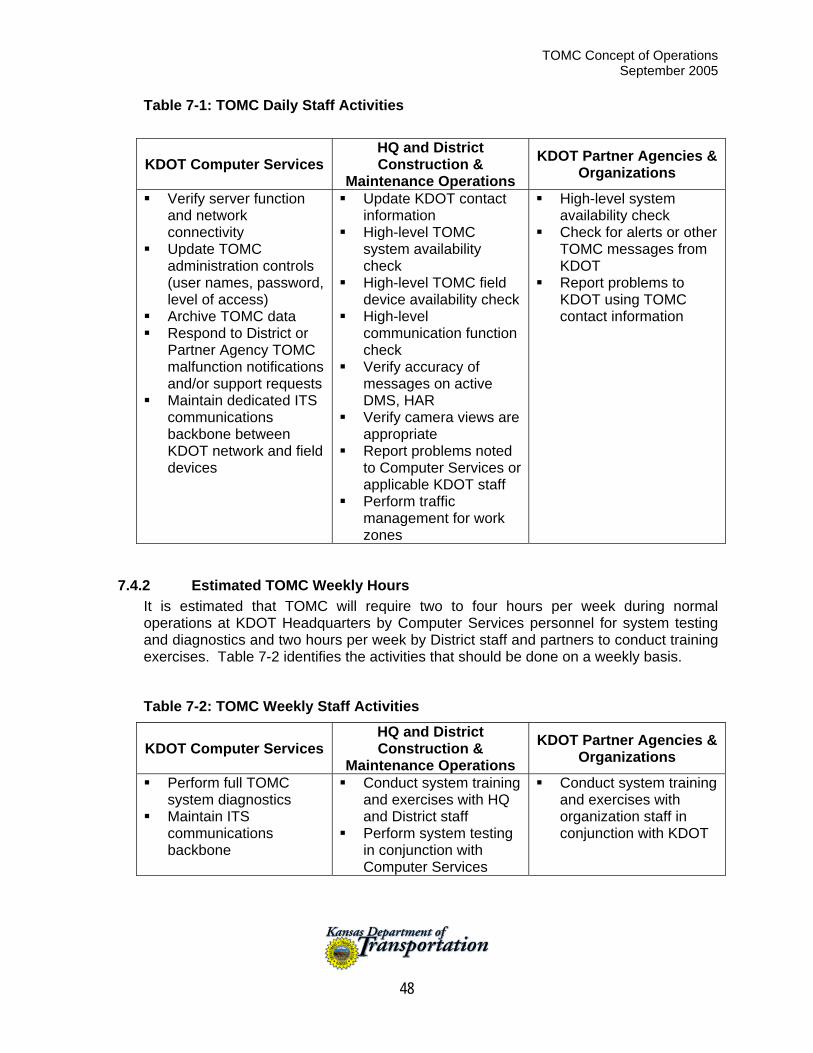
TOMC Concept of Operations September 2005
48
Table 7-1: TOMC Daily Staff Activities
KDOT Computer Services HQ and District Construction &
Maintenance Operations KDOT Partner Agencies &
Organizations
Verify server function and network connectivity
Update TOMC administration controls (user names, password, level of access)
Archive TOMC data Respond to District or
Partner Agency TOMC malfunction notifications and/or support requests
Maintain dedicated ITS communications backbone between KDOT network and field devices
Update KDOT contact information
High-level TOMC system availability check
High-level TOMC field device availability check
High-level communication function check
Verify accuracy of messages on active DMS, HAR
Verify camera views are appropriate
Report problems noted to Computer Services or applicable KDOT staff
Perform traffic management for work zones
High-level system availability check
Check for alerts or other TOMC messages from KDOT
Report problems to KDOT using TOMC contact information
7.4.2 Estimated TOMC Weekly Hours It is estimated that TOMC will require two to four hours per week during normal operations at KDOT Headquarters by Computer Services personnel for system testing and diagnostics and two hours per week by District staff and partners to conduct training exercises. Table 7-2 identifies the activities that should be done on a weekly basis.
Table 7-2: TOMC Weekly Staff Activities
KDOT Computer Services HQ and District Construction &
Maintenance Operations KDOT Partner Agencies &
Organizations
Perform full TOMC system diagnostics
Maintain ITS communications backbone
Conduct system training and exercises with HQ and District staff
Perform system testing in conjunction with Computer Services
Conduct system training and exercises with organization staff in conjunction with KDOT
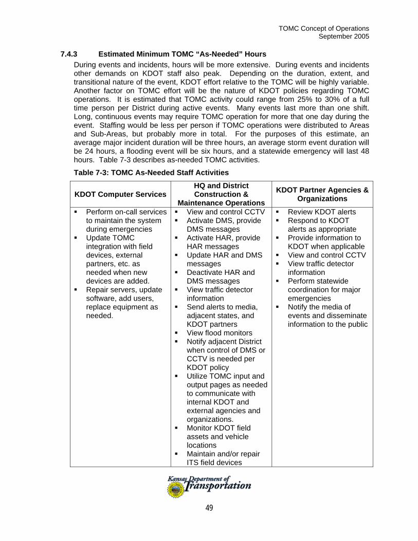
TOMC Concept of Operations September 2005
49
7.4.3 Estimated Minimum TOMC “As-Needed” Hours During events and incidents, hours will be more extensive. During events and incidents other demands on KDOT staff also peak. Depending on the duration, extent, and transitional nature of the event, KDOT effort relative to the TOMC will be highly variable. Another factor on TOMC effort will be the nature of KDOT policies regarding TOMC operations. It is estimated that TOMC activity could range from 25% to 30% of a full time person per District during active events. Many events last more than one shift. Long, continuous events may require TOMC operation for more that one day during the event. Staffing would be less per person if TOMC operations were distributed to Areas and Sub-Areas, but probably more in total. For the purposes of this estimate, an average major incident duration will be three hours, an average storm event duration will be 24 hours, a flooding event will be six hours, and a statewide emergency will last 48 hours. Table 7-3 describes as-needed TOMC activities.
Table 7-3: TOMC As-Needed Staff Activities
KDOT Computer Services HQ and District Construction &
Maintenance Operations KDOT Partner Agencies &
Organizations
Perform on-call services to maintain the system during emergencies
Update TOMC integration with field devices, external partners, etc. as needed when new devices are added.
Repair servers, update software, add users, replace equipment as needed.
View and control CCTV Activate DMS, provide
DMS messages Activate HAR, provide
HAR messages Update HAR and DMS
messages Deactivate HAR and
DMS messages View traffic detector
information Send alerts to media,
adjacent states, and KDOT partners
View flood monitors Notify adjacent District
when control of DMS or CCTV is needed per KDOT policy
Utilize TOMC input and output pages as needed to communicate with internal KDOT and external agencies and organizations.
Monitor KDOT field assets and vehicle locations
Maintain and/or repair ITS field devices
Review KDOT alerts Respond to KDOT
alerts as appropriate Provide information to
KDOT when applicable View and control CCTV View traffic detector
information Perform statewide
coordination for major emergencies
Notify the media of events and disseminate information to the public
TOMC Concept of Operations September 2005
50
7.4.4 Estimated Full-Time Equivalent (FTE) Requirements Based on the estimation of duties and hours per day, per week and per special event required for personnel in each KDOT District, KDOT Computer Services, KDOT Headquarters Operations Division, and partner agencies such as the KHP and KDEM, a total FTE requirement has been calculated for each work group. As shown in Table 7-4, the total FTEs required for each work group per year all fall short of the need for at least one FTE. Partial FTEs are all that is estimated to be required to operate the TOMC in any of the work groups. The importance of this number is that there is likely not enough TOMC duties to keep any one person occupied full-time. TOMC duties will fall upon existing personnel and in addition to other assigned duties. As has been stated by members of the Project Steering Committee and Project Stakeholders, there are very few available FTEs to dedicate to TOMC functions on a full-time basis and that those duties will need to be assigned to existing personnel who already have defined duties. Even though the FTE requirements shown in Table 7-4 are fractional, they are still a significant amount of one person’s total duties, especially in Computer Services and each District. Therefore, when the TOMC duties are assigned, they should be assigned to personnel that have the work load capacity to handle the duties effectively.
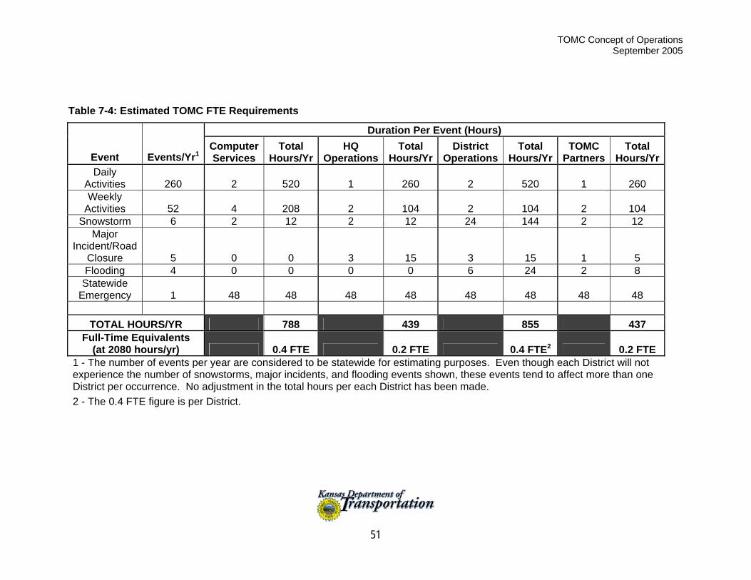
TOMC Concept of Operations September 2005
51
Table 7-4: Estimated TOMC FTE Requirements
Duration Per Event (Hours)
Event Events/Yr1 Computer Services
Total Hours/Yr
HQ Operations
Total Hours/Yr
District Operations
Total Hours/Yr
TOMC Partners
Total Hours/Yr
Daily Activities 260 2 520 1 260 2 520 1 260 Weekly
Activities 52 4 208 2 104 2 104 2 104 Snowstorm 6 2 12 2 12 24 144 2 12
Major Incident/Road
Closure 5 0 0 3 15 3 15 1 5 Flooding 4 0 0 0 0 6 24 2 8
Statewide Emergency 1 48 48 48 48 48 48 48 48
TOTAL HOURS/YR 788 439 855 437
Full-Time Equivalents (at 2080 hours/yr) 0.4 FTE 0.2 FTE 0.4 FTE2 0.2 FTE
1 - The number of events per year are considered to be statewide for estimating purposes. Even though each District will not experience the number of snowstorms, major incidents, and flooding events shown, these events tend to affect more than one District per occurrence. No adjustment in the total hours per each District has been made. 2 - The 0.4 FTE figure is per District.
TOMC Concept of Operations September 2005
52
7.4.5 Typical TOMC Staff Positions The following position descriptions are general in nature but describe what skill sets are necessary for typical positions to be staffed in a TOMC. The FTE requirements noted above do not necessarily refer to just one person, but rather may be a collective of people, each with a particular skill set described below. For the Computer Services FTE, that may include a System Administrator, Communications Technician, and Software/Computer Support. The Headquarters FTE will include skills closely related to that of an Operations Supervisor and System Operator. The District FTE will closely match the System Operator and Operations Center Technician. Partner Agency FTEs will be similar to Operations Supervisor and System Operator. Operations Supervisor / Shift Supervisor: This position is frequently filled by a person who came up through the ranks and achieved competence through a blend of job-related training and personal experience. The supervisor must have a well-developed judgmental skill that allows him/her to distinguish between situations that can be handled within the resources of the operations center and those that require the participation of one or more partner agencies. This person is responsible for the management of previously developed operating plans, including the magnitude of the response to implement based on the type of incident. Another skill highly prized in a supervisor is the ability to teach others how to be excellent system operators. The operations supervisor manages the daily operations of the TOMC operations staff and performs a number of reporting and administrative duties. The shift supervisor is in charge of the staff operations for their shift. Systems Administrator: This position is filled by a person will all of the skills described for the software/computer support position plus this position requires a thorough knowledge of the local area network (LAN) or other network structure that is operating within the TOMC. The system administrator is responsible for the maintenance and upgrading of the TOMC network. The system administrator will maintain the systems security by providing the needed system access to various staff or contractors via passwords. Often the system administrator will manage the software/computer support personnel. System Operator: This is the hands-on position. The system operator must be computer literate and capable of performing many computer-related skills, such as keying in text data and using a mouse. Most ITS systems are actually composites of several different subsystems, so the system operator must be familiar with the operating commands of several different systems. A typical combination could include Highway Advisory Radio (HAR), dynamic message signs (DMS), and ramp metering, as well as a CCTV surveillance system. Each of these subsystems may have a different operator interface, and the system operators must be fully trained on all of the systems. Software/Computer Support: While it is possible for an operating agency to maintain the real-time system software, this is generally not the case. A contractor generally maintains the real-time system software. There is a need, however, for software and hardware support in the operating agency. This level of computer skill would require proficiency in the data base management programming languages, including Oracle® or
TOMC Concept of Operations September 2005
53
Sybase®. In addition, the programmer must be proficient in GIS and CADD software packages (e.g., ARC/INFO®, ArcView®, AutoCAD®, MapInfo®, and Microstation®) and firmware for traffic signal controllers (e.g., National Electrical Manufacturers Association, 170,270, and 2070) on Mac®, Sun®, and HP® platforms, as well as the software specifically installed in the TOMC to manage traffic operations. The primary task of the software/computer support personnel is to maintain the software necessary to track maintenance operations and support the operations function. Communications Technician: This position requires an electronics technician who is trained in the operations of a variety of wireline, wireless technologies, and radio communications (AM and FM) systems supporting video, data, and voice transmissions. An evaluation of the capital cost of the equipment in any ITS system will show that the category with the highest investment is communications. It only makes sense to protect this investment by providing a high level of maintenance. This category is not only the largest but also the one that changes most frequently. As communications hardware evolves, it becomes almost a steady state situation where one subsystem or another is always being upgraded and/or replaced. Operations Center Technician: This is an electronics technician who may be junior to the communications specialists but nevertheless has been trained in the maintenance of digital electronic equipment, particularly microprocessors. This person can identify hardware failure and make repair/replace decisions. The position requires considerable troubleshooting skills as well as the ability to perform all types of testing.
7.5 Communication Needs The development of communication requirements for future ITS infrastructure in Kansas will be the speculative at best due to the lack of knowledge of future deployments, future communications technologies, cost variability (either up or down), use of state-owned infrastructure versus leased communication lines, and potential cost sharing between multiple agencies. The following presents a representation of the communications infrastructure existing in Kansas and future communication options.
7.5.1 TOMC Communication Requirements KDOT is currently using T-1 lines to provide network communication between District Offices. As ITS field devices, particularly traffic cameras, are deployed, the demand for Center-to-Center (C2C) communication will increase beyond the current capacity of the T-1 lines. Network communication to IP addressable devices in the field can be accomplished with most ITS equipment that are only exchanging data such as DMS and detection devices. The use of cameras and transporting of video is going to be the key factor in determining communication requirements. KDOT owns fiber optic cables and conduit across the state as shown in Figure 7-1. These cables can currently, or with additional last mile connections, be used to provide communication between KDOT Headquarters, Districts 1, District 2, and the Kansas City and Wichita urban areas. The fiber can also be used to connect with partner agencies such as KHP and KDEM in the Topeka and Salina areas as well as any ITS elements
TOMC Concept of Operations September 2005
54
that are located along roadways with adjacent fiber optic cabling. Fiber is not currently available to connect to District offices in Norton, Garden City, Hutchinson or Chanute.
7.5.2 Communication Options Center-to-Center Communication Table 7-5 shows several options are available for increasing bandwidth for C2C communications. These options include leasing additional T-1 lines, installing additional fiber, or digital microwave wireless communications. Leasing costs for T-1 lines can be very expensive over the long run. Installation of fiber provides the largest potential bandwidth but also the highest initial costs. Microwave communications may be a cost effective alternative. However, depending on the frequency band utilized, weather could cause disruptions to microwave transmissions. A thorough frequency analysis will be required to ensure frequency availability and line of sight availability for placement of towers.
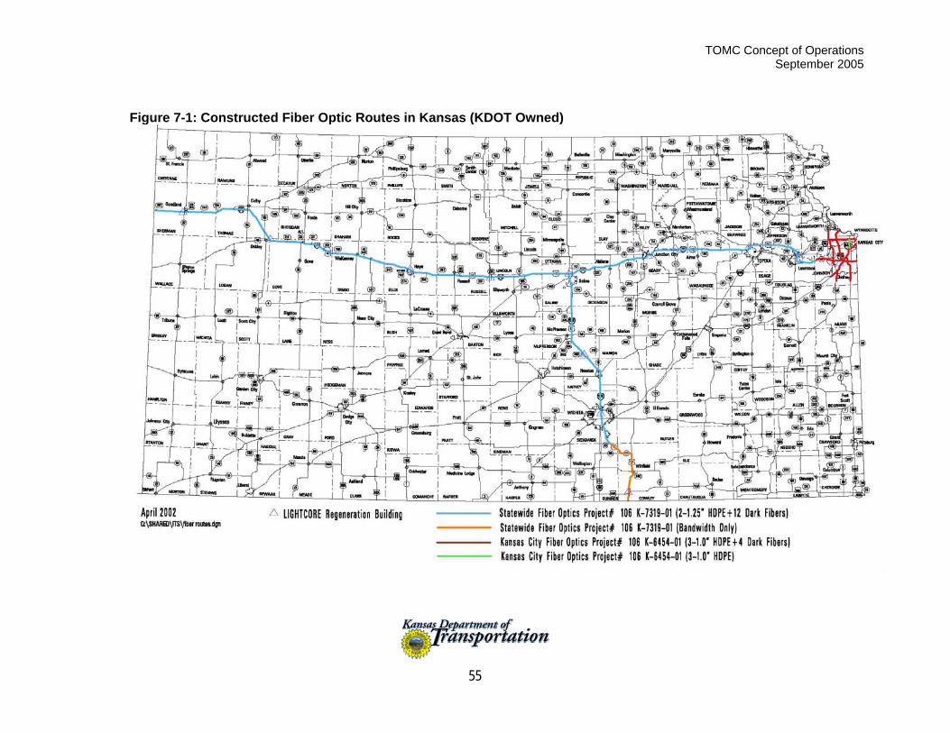
TOMC Concept of Operations September 2005
55
Figure 7-1: Constructed Fiber Optic Routes in Kansas (KDOT Owned)
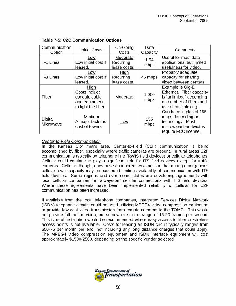
TOMC Concept of Operations September 2005
56
Table 7-5: C2C Communication Options
Communication Option Initial Costs On-Going
Costs Data
Capacity Comments
T-1 Lines Low
Low initial cost if leased.
Moderate Recurring lease costs.
1.54 mbps
Useful for most data applications, but limited usefulness for video.
T-3 Lines Low
Low initial cost if leased.
High Recurring lease costs.
45 mbpsProbably adequate capacity for sharing video between centers.
Fiber
High Costs include conduit, cable and equipment to light the fiber.
Moderate 1,000 mbps
Example is Gig-E Ethernet. Fiber capacity is “unlimited” depending on number of fibers and use of multiplexing.
Digital Microwave
Medium A major factor is cost of towers.
Low 155 mbps
Can be multiples of 155 mbps depending on technology. Most microwave bandwidths require FCC license.
Center-to-Field Communication In the Kansas City metro area, Center-to-Field (C2F) communication is being accomplished by fiber, especially where traffic cameras are present. In rural areas C2F communication is typically by telephone line (RWIS field devices) or cellular telephones. Cellular could continue to play a significant role for ITS field devices except for traffic cameras. Cellular, though, does have an inherent weakness in that during emergencies cellular tower capacity may be exceeded limiting availability of communication with ITS field devices. Some regions and even some states are developing agreements with local cellular companies for “always-on” cellular connections with ITS field devices. Where these agreements have been implemented reliability of cellular for C2F communication has been increased. If available from the local telephone companies, Integrated Services Digital Network (ISDN) telephone circuits could be used utilizing MPEG4 video compression equipment to provide low cost video transmission from remote cameras to the TOMC. This would not provide full motion video, but somewhere in the range of 15-20 frames per second. This type of installation would be recommended where easy access to fiber or wireless access points is not available. Costs for leasing an ISDN circuit typically ranges from $50-75 per month per end, not including any long distance charges that could apply. The MPEG4 video compression equipment and ISDN interface equipment will cost approximately $1500-2500, depending on the specific vendor selected.
TOMC Concept of Operations September 2005
57
8 Conclusion This Concept of Operations is a major component of the Systems Engineering process and is a requirement for any major ITS project to move forward in Kansas. It is intended to act as a guide for the future developers of the Statewide Transportation Operations & Management Center concept. It should be used as a reference and baseline document as the project progresses to ensure that the original functionality sought by project stakeholders is obtained and that project enhancements (scope expansion) are managed in a thoughtful manner. Based on the Concept of Operations, KDOT is developing an Implementation Plan for the Statewide Transportation Operations & Management center project. This plan will eventually lead into a detailed design for the project and allow for KDOT to contract for services to make the Statewide TOMC a reality. KDOT is currently considering the implementation of a pilot project to verify the need, functionality, projected costs, and operational advantages of a TOMC concept in Kansas. Should that pilot project take place, and new operational concepts, new functional requirements, and/or modified functional requirements emerge, then KDOT should modify this concept of operations document. This will preferably be done through a change control process so that new requirements and modifications can be properly tracked. Finally, it should be noted that the development of this Concept of Operations was done with the assistance of hundreds of project stakeholders and several partner agencies to KDOT. As the Statewide TOMC project progresses, these stakeholders and partner agencies should be kept informed of the project’s progress and asked to provide additional input periodically to ensure that their original requirements are being met by the project.