transforming water districts operations using cloud gis … · appurtenances, serving about 34,000...
TRANSCRIPT
TRANSFORMING WATER DISTRICTS’ OPERATIONS USING CLOUD GIS &
HYDRAULIC MODELING
Presented by: Venkatesh Narasimhaiah
Regional Manager, Nobel Systems, Inc.

Abstract: Transforming Water District’s Operations using Cloud GIS and Hydraulic Modeling Mabalacat City Water District (MCWD) operates and maintains a water distribution system comprising of over 310 kilometers of underground pipes and associated appurtenances, serving about 34,000 customers. To maximize benefits of GIS, MCWD decided to adopt Web-GIS and get away from the traditional desktop GIS, which was limited to one department. With its GIS on the Cloud now, all departments of MCWD has unlimited access to GIS, which has not only resulted in reducing time and effort needed to manage MCWD’s operations, but also reduced operational costs considerably. Identifying problem locations and infrastructure is lot easier for engineering staff, while processing new service connection requests is quick and paperless for commercial department folks. Response time to manage leaks has become quicker, with Customer Service staff, liaising with the Operations folks electronically. What more, MCWD runs its hydraulic model on the cloud, to identify and fix supply related issues.

MCWD: Profile ABOUT MCWD -
- MCWD is one of the pioneer Water Districts’ in Philippines; - Formed in 1978 (CCC No. 61); - MCWD currently serves about 33,745 Active Concessionaires:
- 32,427 Residential Connections; - 156 Connections in the Government Sector; - 1,159 Commercial Connections; - 2 Bulk Connections;
- MCWD serves 24 Barangays; - Operates the system on a 24x7 basis; - Source of Water is from 26 active deep well pump stations;
Data as of March 2013

MCWD GIS Implementation - Road Map - 2009: GIS INCEPTION - THRU‘ A GRANT RECEIVED FROM USTDA - Primary Objective: Work on a Pilot Area and do Feasibility Studies for NRW Reduction; - Project used GIS, SCADA & Hydraulic Modeling; Results were quite significant;
- FULL-ON GIS - MCWD decided GIS Implementation for remaining areas in Phases, due to budget limitations; Phase I - 2009; Phase II - 2010; Phase III - 2011; - Digitalized Mainline, Valve, Hydrant, Pump Station, Reservoir, Service Meter Data, etc.; - Developed Customer Service Connections Database
- POST GIS - FOCUS WAS ON MITIGATING PRESSURE & FLOW ISSUES - In 2012, MCWD called for Hydraulic Modeling Services; - Developed a Hydraulic Model for the MCWD’s Distribution Network; - Identified ‘Bottlenecks’ in System; Currently working on Modeler’s recommendation;
- FUTURE ACTIONS PLANS FOR BETTER MONITORING - Develop a Master Plan; - SCADA Development & Integration with GIS, Fleet Vehicle Management System, etc.;

Challenges & GIS Benefits at MCWD - Challenges at MCWD (Prior to GIS Implementation) -
• As any Water District, MCWD many challenges to confront – Aging Infrastructure ; Regulatory Compliances; Desire to Maximize Staff Productivity
• Paper-based systems were not quite up to the task – Difficulty in getting aggregate Info.; Difficulty to Produce Reports; Limited Access to Information
• No Integration & Communication between Systems, Data and Departments – Systems and tools to meet the different business needs, need to be acquired and integrated – Anywhere and anytime access is crucial for operations
Benefits Derived by GIS Implementation -
• Centralized Data Sharing - Enabled data sharing across Depts., enabling Streamlined Work Management and Efficient Manpower Usage
• Enhanced Service Delivery- Response Time to attend to complaints was reduced, & Connection/Disconnection now managed well
• Efficient Use of Equipment - Fixing Issues and Maintenance has become easier, since asset locations are known/familiar
• Reporting & Analysis - Thru’ Integration with Billing System & Hydraulic Modeling

MCWD GIS: Pictorially -
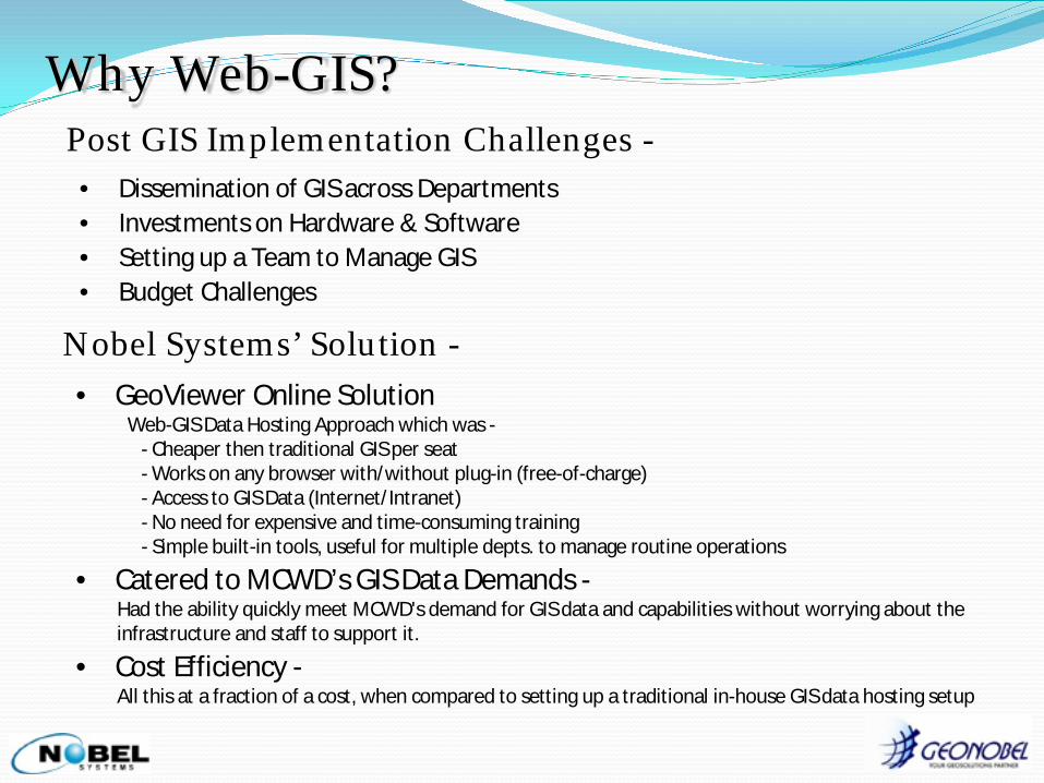
Why Web-GIS? Post GIS Implementation Challenges -
• Dissemination of GIS across Departments • Investments on Hardware & Software • Setting up a Team to Manage GIS • Budget Challenges
Nobel Systems’ Solution -
• GeoViewer Online Solution Web-GIS Data Hosting Approach which was -
- Cheaper then traditional GIS per seat - Works on any browser with/without plug-in (free-of-charge) - Access to GIS Data (Internet/Intranet) - No need for expensive and time-consuming training - Simple built-in tools, useful for multiple depts. to manage routine operations
• Catered to MCWD’s GIS Data Demands - Had the ability quickly meet MCWD's demand for GIS data and capabilities without worrying about the infrastructure and staff to support it.
• Cost Efficiency - All this at a fraction of a cost, when compared to setting up a traditional in-house GIS data hosting setup

GeoViewer Online: • GeoViewer Online is a web-based GIS which allows user to view Geospatial Data
(GIS layers, aerial/satellite imagery, document, reports, and any other digital document in raster or vector format).
• Built on Microsoft ASP.NET & Adobe Flex, works ArcGIS Server technology which is ESRI’s latest and most powerful technology in the GIS industry.
• GIS Data resides on SQL Server.
GeoViewer is a simple and easy to use interface, designed for Non-GIS Professionals, requiring minimum effort to learn!!
Functionalities / Tools -
- Integrate with multiple map servers - Links to scanned images/pictures/reports/etc - Valve Isolation - Generate Mailing Labels - Create maps for field crew - Links to external data - And much more...

GeoViewer Online - Functions BETTER UNDERSTANDING OF ASSET LOCATION
Where are all 100mm PVC Pipes??
Search In the GIS - Information available at a
Click of a button….
Need to know location of a Fire Hydrant in 50m proximity!
Where is Valve Number 005?
Where is the location of Customer Account Number 102-0354?

GeoViewer Online - Functions ABILITY TO VIEW DETAILED INFORMATION
Select a Water Mainline & see its details
Identify In the GIS - Detailed Information can be seen just with a mouse click
Click on the PDF icon - To view Original Drawings/Maps
Ability to view ‘Disconnected Meters’
differently
View Valves to be ‘Turned Off’ & Affected Customers - During
Maintenance

GeoViewer Online - Functions ABILITY TO VIEW DETAILED INFORMATION
Printing Maps is just 1-Click
Print Maps & View Reports in GIS
Pump Station Details can be viewed
Ability to view ‘Reports & Pictures’
of Critical Assets
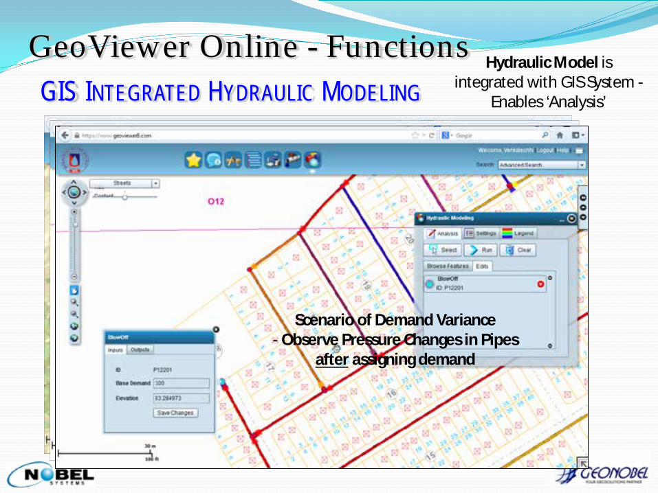
GeoViewer Online - Functions GIS INTEGRATED HYDRAULIC MODELING
MCWD’s Pressure & Flow Under Normal Conditions
Hydraulic Model is integrated with GIS System -
Enables ‘Analysis’
Scenario of Demand Variance - Observe Pressure in Pipes before assigning demand
Scenario of Demand Variance - Observe Pressure Changes in Pipes
after assigning demand

GeoViewer Online - Applications NO FIELD INSPECTION FOR PROCESSING NEW CONNECTIONS
Before GIS Scenario - New Customer
Application Processing
• Field Inspection
• Feasibility Checks
• Taking Measurements
• Time Consuming
… Laborious & Time Consuming Process!!
Customer Service Officer
After GIS -
• Access GIS Data
• Zoom to Location
• Does Feasibility Checks
• Measures Distance
• Faster Estimate Preparation
Satisfied Customer!!

BETTER MANAGEMENT OF LEAKS - MINIMIZING NRW WD receives a call
reporting ‘Leak’
Collects Reported Information
Access GIS - Does ‘Search’ by
Location
Customer Service Officer
Generates a Map of ‘Leak’ Location
Creates a Leak Report attach Map and Email
Maintenance Dept.
Maintenance Dept. repair leak and report
back
Report saved for linking with GIS and for future references
Quick Action Taken… Water Losses Minimized…
Additional Savings for the WD!!
GeoViewer Online - Applications

Questions / Discussion:

Thank You!
Visit us at Booth# 1207 Philippines Office: GeoNobel, Inc., 612, City & Land Mega Plaza, ADB Ave., Ortigas Center, Pasig City, 1605, Metro Manila, Philippines Landline: +63 2 7035288 Tel & Fax +63 2 4707429
U S Office:
Nobel Systems Inc., 436 E. Vanderbilt Way,
San Bernardino, CA 92408, USA
Landline: +1 (909) 8905611 Fax: +1 (909) 890 5612
Web: www.nobel-systems.com